Article

An Ecological Service System Based Study on Suburban Rural Landscape Multifunction

1
School of Landscape Architecture, Nanjing Forestry University, Nanjing 210037, China
2
The Collaborative Innovation Center of South China Sea Studies, Nanjing University, Nanjing 210093, China
3
School of Geographic & Oceanographic Sciences, Nanjing University, Nanjing 210037, China
4
School of Architecture, Soochow University, Suzhou 215006, China
*
Author to whom correspondence should be addressed.
Land 2021, 10(3), 232; https://doi.org/10.3390/land10030232
Submission received: 3 February 2021 / Revised: 22 February 2021 / Accepted: 22 February 2021 / Published: 25 February 2021
(This article belongs to the Special Issue Land Use Optimisation)

Abstract

:
Suburban rural landscape multifunction has received increasing attention from scholars due to its high demand and impact on main urban areas. However, few studies have been focused on suburban rural landscape multifunction because of data constraints. The present study quantified the four landscape services based on ecological service system, i.e., regulating function (RF), provision function (PF), culture function (CF), and support function (SF), determined the interaction through the Spearman correlation coefficient, and ultimately identified the landscape multifunction hotspots and dominant functions through overlay analysis. The result indicated that suburban rural communities have exhibited the characteristics of regional multifunction, and the landscape multifunction hotspots accounted for 64.2%; it should be particularly noted that, among single-function, dual-function, and multifunction hotspots, both support function, and culture function was dominant, while only one case was found in which the regulating function was dominant. Furthermore, all landscape functions other than SF-CF exhibited certain correlations. The study suggests that planning and management should be performed in future in combination with landscape multifunction to ensure the sustainable development of suburban rural communities.

Graphical Abstract

1. Introduction

As a basic unit component of the rural regional complex, rural landscape performs important functions in society/culture and landscape/nature protections; it reflects the cultural connotation and spiritual essence of different regions. However, rural landscape is not evenly distributed because it depends on the socioeconomic and biophysical changes of landscape, and the interaction of space and time among components of the landscape [1,2,3]. Considering the diversity of human needs and activities and the finiteness of natural ecosystems, the functions and ways of utilization of rural landscape as a surface complex become more diversified with the enhancement of human activities. With the rapid growth of urbanization and rural tourism in China, the spread of diversity of human goals brought about continual enhancement of landscape multifunction under the finiteness of natural ecosystems; the rapid growth of urbanization promoted the suburbs of metropolises to face more stringent requirements for multifunction [4]. Therefore, for the sustainability management of suburban rural landscape and the improvement in human wellbeing [5], it is necessary to explore the correlation between ecological processes and landscape functions.
Landscape function refers to the interaction between landscape structure and ecological process or landscape structure unit [6], and is incarnated by the structure of landscape and the processes and functions of ecosystems embedded in landscape structure; essentially, the concept of landscape function comes from the theory of ecosystem function; it is principally used to describe the capability of landscape to provide products and services closely associated with human wellbeing [7]. In view of the homology of ecosystem service and landscape function, the diversity of ecosystem services is also regarded as the material basis of landscape multifunction [8]. Despite the similarity in definition, they do not share the same subjects and scales of study; the landscape function attaches greater importance to the importance of spatial pattern, spatial configuration, and spatial heterogeneity of landscape [9,10]; landscape is a spatial composite system of interaction between humans and the environment, while ecosystems are often regarded as natural and seminatural systems. Hence, landscape service function can better describe the ecosystem and landscape spatial structure and functions under the influence of human activities. Additionally, landscape and ecosystem are hierarchically related to each other; the latter is an essential component of the former’s decision makers, while landscape function and ecosystem service are homologous; therefore, the integration of both represents a new orientation of development [11]. Multilandscape service function collaboration constitutes the landscape multifunction; scholars at home and abroad tried to define it, but they have not reached a consensus. Most researchers attempt to study landscape function and tradeoffs for large areas, but landscape function varies depending on the type of area and exhibits obvious territoriality; internationally, there are some doubts about this. Accordingly, in collaborative analysis-based landscape function recognition, it is essential to focus on the background of different types of research areas, such as urban centers and fringes, and to identify different human needs for landscape space within areas, thereby identifying the most prominent landscape function for the main function objective of a specific area, and achieving the overall and coordinated development of landscape function in different areas. If rural communities are extensively dominated by natural land cover, we can naturally regard ecosystem service as landscape function; otherwise, it is necessary to bring other factors under landscape function. Therefore, an effective approach is presented based on ecological service system and landscape multifunction to clarify the multifunction of rural landscape, especially for suburban rural communities.
Landscape multifunction assessment is not only considered a powerful tool for tradeoffs among landscape functions [12,13], but also regarded as an effective way to achieve the sustainable development of landscape. Over the past few decades, researchers’ traditional attention to spatial dimensions has made the assessment and identification of landscape multifunction based on spatial mapping a trend, scholars have carried out much research thereon [14,15,16]; performing quantification in a spatially specific manner and analyzing the tradeoffs between them could bring about more effective and reasonable natural capitals [17]. Attempts have been made to combine information about explicit provision of ecosystem services with the information about locations of such functions [18]. With the numerical spatial differentiation of landscape function in mind, the GIS spatial overlay analysis-based quantitative identification of multifunctional landscape hot spots with multiple high landscape function values has become a basic research paradigm for multifunctional landscape space recognition. Nature-based tourism is very important for the social–ecological sustainable development of rural suburbs, but the difficulty in acquiring rural data causes people to study the functions of suburban rural landscape mostly in qualitative or semiquantitative research, where expert experience and qualitative weights play an important role; in particular, cultural services are often the most difficult to understand and quantify [19]. Furthermore, previous common observational data were mostly land use types and land cover based on an ecological service system, but the data available are insufficient to quantify these landscape functions [20]. Hence, various spatial attributes (principally biophysical and socioeconomic) are considered as indicators for quantitation of landscape functions. Added to this, the development of big data provides opportunities for research on rural landscape functions; researchers use Point of Interest (POI) data to quantitatively analyze the functions of cities, thereby offering new ideas for landscape function recognition.
The inevitable urbanization has a much greater impact on the rural communities around the metropolis than on the remote rural communities; this results in the evolution of landscape function [21]. Under the strong economic drive during urban expansion, intricate special types of rural landscape came into being in suburban rural communities of Nanjing, one of the most economically developed international metropolises in China. Suburban rural landscape involves multifunctional land use, complex history and present situation, and industry and planning appeals; this implies that it is necessary to change from seeking independent sustainable rural models into focusing on thinking about the coexistence of regional elements, and the relationships among components, from the perspective of the “function” or “service” of the eco-to-urban system. Moreover, the realization of individual sustainable development in suburban rural communities need to be considered over a larger area.
Taking Jiangning District, Nanjing, as an example, the present study chose four key landscape functions, i.e., regulating function, provision function, culture function, and support function, to determine the landscape multifunction based on ecological service system and multifunctional landscape. Their interactions were determined, and the landscape multifunction hotspots and dominant functions were analyzed. We focused on the following issues: (i) the spatial distribution of four quantitative landscape functions; (ii) comparing and analyzing the tradeoffs and synergy among landscape versatilities; (iii) identifying the spatial distribution of landscape multifunction hotspots in suburban rural communities; and (iii) analyzing the dominant functions in landscape multifunction hotspot areas. The fundamental purpose was to explore and study the multifunction of rural landscapes in the suburbs of cities during the rapid urbanization in China, thereby providing guidance for landscape planning and management in synergistic development of rural ecosystem and society.

2. Materials and Methods

2.1. Study Area

The reason why Jiangning District of Nanjing was chosen as the study area is that the landscape functions are diverse and have consistent legislation and socioeconomic contexts; comparison of the entire landscapes is allowed, and the system to be evaluated is clearly defined. The terrain of study area is saddle-shaped (high at both ends, and low in the middle). The area accommodates 400 hills, all of which are below 400 m above sea level, where the normal landforms include low mountains, hills, downlands, plains, and basins (known as the combination of “six hills, one river, and three plains”). Abundant elevation differences lead to gradients in many biophysical conditions (e.g., hydrology and soil); the diversity of biophysical conditions constitutes the basis for diversification of land use and land cover.
Nanjing is not only the capital of Jiangsu Province, but also one of the most developed international cities in China. After a rapid urbanization process, the urbanization rate reached 83.2 percent in 2019 and the population reached over 8 million. There are 11 districts in Nanjing. Jiangning District is located in the southeast of Nanjing, which surrounded its main urban area from the east, west, and south. It is only 15 km away from the city center landmark named Xin Jiekou, and the whole district consists of 10 subdistrict-level administrative units. (Figure 1). The study area covers an area of 157,300 hectares, of which 70.1% is agricultural land (cultivated land, garden land, forest land, and other agricultural land), while 23.2% is for construction land. With 1.3473 million permanent residents, the study area comprises 190 rural communities, including 1500 natural villages; there are 73 cultural heritage protection areas at or above the municipal level within the study area. These villages with cultural heritage have stimulated the development of tourism in the area (33.06 million tourist-times received in 2017), and Jiangning District is the only typical case selected for the rural revitalization strategy of Jiangsu Province.

2.2. Study Data

2.2.1. Basic Statistics of Jiangning District

The basic data used for the study are rural community data obtained through the Jiangsu Provincial System (Figure 2a). Through GIS coordinate transformation, 190 entries of distribution data of Jiangning District, Nanjing were eventually obtained.
To explore the distribution of landscape resources in Jiangning District, the following data were gathered. First, 604 entries of POI data of recreation and entertainment were obtained through Baidu, and the data on distribution of bus stations and rail transit in the District were acquired; second, the spatial distribution of preservation of cultural relics was identified based on the data set of cultural relics protection organizations in Jiangsu Province (2019); third, the road network vector data of Jiangning District, Nanjing was achieved through the “Open Street Map” platform.

2.2.2. Land Use Classification Data of Jiangning District

To analyze the land use conditions in rural communities around Jiangning District, Nanjing, the present study employed the remotely sensed image data acquired by Sentinel 2 Satellite for the District on 22 May 2019, with an accuracy of 10 m × 10 m by European Space Agency (ESA) (https://www.esa.int/, accessed on 2 February 2021) and “image cloudiness 0–10, product grade 1C” chosen. During the image interpretation, 140 training samples were taken from the study area based on Google Earth for supervision classification and visual interpretation; then, the maximum likelihood algorithm was used to assign homogeneous pixel groups to the types of land use identified. The land use classification and the classification system was established for remotely sensed image interpretation based on current land use and the land use change conditions as per the Chinese standard for classification of land use (2019); the land was classified into cultivated land (irrigable land, dry land, and vegetable land), forest land (trees, shrubbery), grassland (natural grassland and artificial grassland), waters (wetlands, rivers, reservoir fishery, and lakes), building land (residential, industrial; commercial and transportation land in the study), and unused land (bare and idle land). The vector boundary of Jiangning District, Nanjing, was extracted from the national 1:1 million basic data, and ENVI 5.5 software (Environment for Visualizing Images) was used as a remotely sensed image data processing platform for the preprocessing, fusion, mosaic, trimming supervision classification, and accuracy check of remotely sensed images. The kappa coefficient and overall accuracy were calculated from confusion matrices to assess the classification accuracy. According to the classification result, the kappa coefficient was 0.93, and the overall accuracy was 96.06%. In the end, the land use classification of Jiangning District was identified through the editing operation with ArcGIS Pro software (Figure 2b).

2.3. Analysis Method

The study was conducted in four steps. First, four key landscape functions (regulating function, provision function, culture function, and support function) were identified from the perspective of ecological environment and human society, and the space was explicitly quantified through the ArcGIS Pro software. Second, the correlation among different pairs of landscape functions was studied through overlay analysis based on Spearman rank correlation. Third, hot spots with multiple landscape functions were analyzed. Fourth, the dominant functions in landscape multifunction hotspots were analyzed (Figure 3).

2.3.1. Landscape Multifunction Classification Criteria

There are significant differences in landscape functions, and they all have different attributes; therefore, different methods and data sources are needed to identify landscape functions. The classification system used in the UN Millennium Ecosystem Assessment (MA) has been generally recognized, because it elaborates the relationship between the natural ecosystem and wellbeing of human society. However, such a classification system emphasizes the functions of natural systems; furthermore, the classification system [22] established by de Groot (2006) stresses the services and functions of landscape to society. It comprises regulation function, habitat function, production function, information function, and support function. The support function summarizes human activities contrary to the original ecosystem. Therefore, based on the two categories noted above, with regional characteristics in mind, the present study classified the landscape functions into provision function, regulating function, culture function, and support function. The spatially quantified data of the four landscape functions based on the index system established, as per findings of previous researchers [23,24,25], represent the rendered landscape services; this enabled landscape function analysis.
Suburban rural landscape provides humans with food, timber, water source, and other products, which is referred to as provision function; it reflects the resources produced by the natural ecosystem. The ecological greenery of suburban rural communities plays its role in regulating climate and improving the environment of urban and rural communities; it corresponds to the regulating function. It results from the capacity of ecosystems and landscape to influence a variety of biological processes [26]; regulation functions maintain a “healthy” ecosystem at different scale levels [22]. Since landscape serves as “natural resource provider” in the provision and regulating functions, the land use classification is adopted as the index basis. The study determined the percentages of various ecosystem service values generated by different types of land use based on the ecosystem-service value-equivalent table for different types of land use in China, corrected by Xie Gaodi (2008). Based on expertise, the results were taken as the basis for classifying landscape resources in rural communities in Jiangning District, Nanjing (Table 1). The tourism resources and geographical advantages of suburban rural communities meet human mental needs, such as leisure and recreation, which is classified as culture function. Culture function assessment was subjective before, because they were affected by behavioral habits of individuals [23]; this caused cultural function assessment to be more challenging than assessment of the other functions. Every effort was made to eliminate subjective factors in function assessment with the culture function proposed by deGroot. Besides, only a few of the culture functions studied considered the connection with health; natural and designed green spaces not only help reduce stress [27], but may also enhance walking and physical activity patterns; therefore, the functions of grassland, cultivated land, forest land, wetland, and water were taken into consideration. Support functions mainly supply the other three types of functions, so as to maintain the stable and healthy development of the ecosystem, and thus support functions can be ignored in the ecosystem service value of land use type [28]. In addition to meeting our basic needs, landscape function needs to address other requirements that are associated with internal resources (land use) and other uses (residence, construction activities, etc.). Most human activities (e.g., farming, housing, transportation) require space and suitable substrate (land) or medium (water, air) to support related infrastructure; the use of support function normally involves the permanent transformation of the original ecosystem [22]. Therefore, the support function addresses the artificial environments such as transport function and construction function. The transport function determines the accessibility of space, which measures the extent to which the land use transport system employs (one or more) specific means of transport (combination) to enable individuals to reach their destinations [29]. Entertainment and tourism in culture function largely depend on the accessibility of space, but this concept is rarely used in ecological service systems [30]. To evaluate the landscape function of suburban rural communities, the quantifiability and availability of data should be considered; on that basis, we selected 10 indicators for the four landscape functions; see Table 2 for the quantification of the specific indicators.

2.3.2. Landscape Function Assessment

Prior to landscape function assessment, it is necessary to construct a Thiessen polygon buffer centered on rural communities to identify the space radiation area of each rural community (Figure 2b). Thiessen polygon (also known as Voronoi) is a result of spatial plane division. According to the characteristics of Thiessen polygon construction, the resource points that fall within the radiation zone are closest to rural community; it can better reflect the actual conditions attributed to its ability to estimate the level of unmeasured points based on point source data; it can also form a nonpoint source distribution to achieve the point-to-surface transition, thereby incarnating the features of spatial distribution continuity [30].
The landscape functional index system of rural communities in Jiangning District, Nanjing, was established in four dimensions (culture function, regulating function, provision function, and support function of landscape) to determine the landscape function status in the four dimensions, respectively, and ultimately reach the integrated landscape multifunction evaluation result.
The technical process follows:
First, seven impact factors (cultivated land, forest land, grassland, wetland, water, construction land, and unused land) were chosen based on the land use classification map; then, the value percentages of various landscape functions of different land use types were worked out based on the function ratio of each factor; the levels of provision function and regulating function were determined through overlay after normalization. Second, the culture function-to-aesthetics ratio, leisure and entertainment POI data, and cultural heritage protection data specific to the land types in Jiangning District, Nanjing, were chosen as quantitative indicators. These results were normalized and superimposed to achieve the classification of culture functions available for each buffer. Finally, two support function factors (the area of construction land and the traffic accessibility) were selected to analyze and assess support function through integrated overlay.
To eliminate the difference between landscape function units, we standardized the value of the landscape function within the range 0–1; this effectively averts the inconsistencies in comparative analysis resulting from different function units. In consideration of the inconsistent dimensions and units of various indicators, each evaluation indicator was normalized by the extreme processing method, and the extreme values were identified based on the maximum and minimum values of each indicator. The computing formula follows:
X i j = X i j X min X m a x X min
where X i j represents the jth indicator value of the ith rural community; X i j denotes the standard value of the jth indicator of the ith rural community; X min and X m a x are minimum and maximum values of the jth indicator, respectively.

2.3.3. Interactions among Landscape Functions

It is impossible to quantitatively describe the complex interactions among landscape functions, but space overlay analysis is an effective way to identify hot spots, among which the values of a series of landscape functions are at a higher level. More in-depth understanding of tradeoff and synergy among landscape functions offers a scientific basis for integrated management of multifunctional landscapes so as to better promote human and ecosystem wellbeing. The interaction among different landscape functions is classified into three categories [7]:
Synergy category—when the improvement of one function leads to the increase of another, there is a synergy between both; if the coefficient is positive, potential synergy may occur.
Tradeoff—where one function is improved at the expense of another, there is a tradeoff between both [31,32]. If the Spearman rank correlation coefficient is negative, there may be conflicts between landscape function pairs, which imply the tradeoff between two landscape functions.
Neutral effect—where the increase in one function does not cause the increase or decrease in another, the interaction between both is interpreted as neutral. When the coefficient is zero or the correlation between landscape functions is insignificant, landscape functions may be compatible with each other.
To test and quantify the relationship between each pair of landscape indicators, Spearman rank correlation was performed with SPSS25.0.

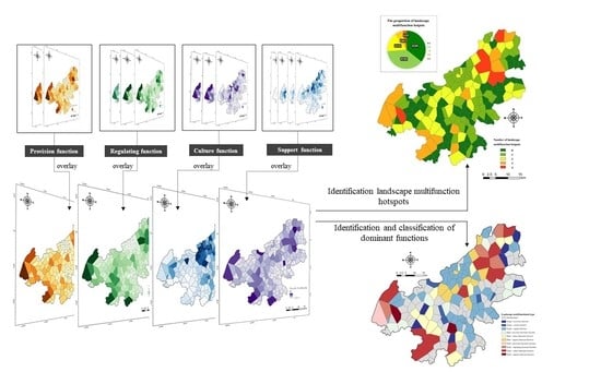
2.3.4. Landscape Multifunction Identification

Landscape functions can be overlapped together on the space. That is, the pixels in space may illustrate various landscape functions. Such areas can be defined as supply areas of multifunctional landscape. The space overlay method is used to identify the multifunctional landscape supply areas; for each landscape function, the mean value is taken as the criterion; if the value of the area is higher than the average, the area is defined as 1. This shows that the area can offer powerful landscape functions. If the value of the area is below average, it is defined as 0, which indicates that the area cannot provide powerful landscape functions. With criteria in mind, if the coverage value of an area is 0, it will be defined as a nonfunctional landscape. If its overlay value is 1, it is a single-function landscape; if its overlay value is greater than 1, it is a multifunctional landscape.

2.3.5. Identification of Dominant Function of the Landscape Multifunction

The specific combination of landscape functions and dominant functions are a critical feature of area landscape; it determines the different types of development. For instance, overall analysis is performed by combining multifunctional landscape management and local development plans to avoid independent and unrelated entities [33,34]. ArcGIS Pro was used for statistics of the four functional indicators (normalized values) within the Thiessen polygon of each rural community; based on the landscape multifunction hotspots 0–4, the landscape function with the largest value was chosen as the dominant function, and this classified the landscape functions, naming them by the combination of landscape functions.

3. Analytical Result

3.1. Landscape Function Identification in Suburban Rural Communities

According to the results of the four landscape functions (Figure 4), the function of the study area varies greatly; its spatial heterogeneity is very obvious, and every landscape function has remarkable spatial clustering. Furthermore, there are some areas that maintain high levels of all three landscape functions. Specifically, high-value areas of provision function and regulating function are concentrated around the Changliu Basin, in Qinglong Mountain, and in Fangshan Mountain. High-value areas are normally rich in water resources and lush vegetation. High-value areas of the culture function radiate to the surroundings with Fangshan Mountain and Qinglong Mountain as the center, while the high-value areas of support function are concentrated between two mountains; beyond all question, this is due to their proximity to the main urban area of Nanjing (Qinghuai District, Yu Huatai District, and Xuanwu District). The rapid expansion of urbanization results in improvements in transportation and building infrastructure. In addition, the development of the central area of Jiangning District is restricted by two mountains, which are mainly the mountainous terrain in the northeast and southwest; thus, it is a high concentration area of support function.

3.2. Relationships among Landscape Functions

Spearman correlation rank test was performed on the four landscape functions in Jiangning District using the SPSS25.0 software. As illustrated in the table (Table 3), two of the six pairs of landscape values (i.e., SF–RF and PF–PF) exhibit negative correlation; the other three pairs of landscape values (i.e., PF–RF, CF–PF, and CF–RF) exhibit obvious positive correlation. There is only one pair of values (i.e., SF–CF) exhibiting no correlation.
PF and RF have the highest correlation among all landscape indicators. A positive coefficient implies that provision and regulating functions in landscape are synergistic, because forests and waters play a leading role in these two functions; hence, both may share the same tendency in space.
SF is negatively correlated with RF and CF, which indicates that PF conflicts with these two landscape functions to some extent. It is caused by disturbances in artificially constructed areas that can significantly change land cover types; for instance, destruction of soil structure may affect soil nutrients, thereby accelerating the reduction of cultivated land, grassland, etc.
The correlation between SF and CF is not significant, which indicate that they are compatible with each other in the study area. In densely populated areas with well-developed transportation, the vegetation coverage is normally low and the cultural heritage attractions are generally not too dense; therefore, it is impossible for SF and CF to remain at a high level simultaneously.

3.3. Landscape Multifunction Evaluation

The spatial distribution map of landscape multifunction can be attained by overlaying various landscape functions. The results are shown in Figure 5. Approximately 64.2% of the rural communities in the study area could provide at least one landscape function. Furthermore, 37.9% could offer only one kind of landscape function hotspot. Approximately 37.9% of the residence communities in the study area offered two functions. The areas defined as multifunctional landscape hotspots that can keep three or four landscape functions at a high level accounted only for 9.9% of the total number of rural communities. This shows that most of the area can provide landscape services for humans, while rural communities offering high-quality multiple landscape service functions were only concentrated in a few areas. Landscape multifunction hotspots are principally located in the Tangshan and Fangshan Subdistricts in Jiangning District, especially the rural communities near Qinglong Mountain and Fang Mountain; there were also some landscape multifunction hotspots around the Yangtze River.

3.4. Classification of Landscape Multifunction

According to statistics, rural communities could be classified into 10 categories according to the mix of their landscape functions (Figure 6). In the event of individual dominant functions, the support function accounts for 83.3% (60), the dominant provision function accounting for 9.7% (7), and the dominant culture function accounting for 6.9% (5). Single-support dominant functions were principally distributed in the middle of the study area, and the remaining single-dominant functions were scattered; dual functions fall into three categories (dual-provision dominant function, dual-culture dominant function, and dual-support dominant function). Dual-culture and dual-support dominant functions accounted for similar proportions, i.e., 32.3% (10) and 41.9% (13), respectively; dual-provision function accounted only for 2.6% (8). The 20 multifunctional rural communities could be classified into four categories, i.e., multi-provision dominant function, multi-culture dominant function, multi-regulating dominant function, and multi-support dominant function. Dominant culture function was in a great measure, accounting for 60% (12), while the regulating-dominant function accounted only for 5% (1). Areas with multi-landscape function were principally concentrated around the Yangtze River Basin and in Qinglong Mountain and Fangshan Mountain.

4. Discussion

4.1. Superiorities of Multifunction Identification of Suburban Rural Landscape Based on Multi-indicator Areas and Buffers

Evaluating the suburban rural landscape multifunction to quantify the importance of landscape configuration to human wellbeing and identify the key driving functions may be a reasonable and feasible approach to the paradigm of rural landscape sustainability [35]. This study proposed a comprehensive landscape service function framework for studying the suburban rural landscape multifunction; special emphasis is placed on quantifying and mapping multiple landscape functions, evaluating the interaction relationship, and classifying suburban rural communities. This analytical framework was established from the perspective of natural ecology (vegetation, water, etc.) and society (culture, transportation, etc.). The methods for estimating overall quantitative landscape function are widely accepted models and methods that can explicitly draw spatial functions [36]. Few studies have been focused on landscape multifunction mapping due to the confinement by spatial data availability and spatial–temporal scale. The development of spatial data in recent years stimulated researchers to identify and evaluate landscape functions based on land utilization/cover data on a global scale. On the regional scale, however, the land utilization/cover data failed to fully reflect the distribution of landscape service functions, so it is essential to comprehensively consider social, cultural, and other factors as quantitative indicators; this supports decision making on utilization and management of regional landscape services. The data used in this study are readily available, including remote sensing data, POI data, and social statistics.
For the study, the rural Thiessen polygon buffer was taken as the spatial unit of overlay analysis, in contrast to quantitative evaluation and hotspot recognition (i.e., grid); its purpose is to effectively integrate landscape functions with community administrative units for overall planning of socioeconomic development and environmental protection. For suburban rural communities, it is important to develop specific function plans based on geographical locations and spatial adjacency of multiple landscape functions so as to improve landscape multifunction [37]. Accordingly, the method based on rural community unit buffer is the key to understanding how the multifunctional landscapes interact with the land in social processes.

4.2. Discussion on Landscape Multifunction Hotspots and Dominant Landscape Function Areas in Suburban Rural Communities

The result of our quantitative study on the 190 rural communities clearly shows that spatial difference of landscape multifunction came into being in suburban rural communities; for example, apparent formation of regional multifunction characteristics was observed in areas of Qinglong Mountain and Fangshan Mountain. In detail, the two areas have rich cultural heritage and natural resources, and also contained numerous rural communities with large populations and complete support facilities. A number of studies have shown that urbanization and industrialization are dominant factors affecting the multifunction development of suburban areas; what are the functions that the current suburban rural communities can provide for humans? This is a question that needs to be discussed. Nanjing’s Opinions on Promoting the Implementation of the Rural Revitalization Strategy for year 2020 mentioned “industrially thriving and ecologically livable”; for suburban rural communities, it is essential to take into comprehensive consideration the urbanization and the characteristics of rural communities, so as to highlight the dominant function of developing different rural communities.
Moreover, since spatial conditions of land use in suburban rural communities are extremely different from those in other rural communities, the functions and values provided to the urban public (such as landscape features) need more social recognition [38]. As shown in Figure 6, suburban rural communities are principally dominated by support and culture landscape functions, where the role of the regulating function is next to nothing. It is worth noting in the present study that, first, areas with high value of support function have fewer landscape multifunction hotspots. Multiple functions provided by suburban rural communities often conflict with each other; to make it more concrete, the forests, wetlands, waters, etc. that dominate regulating function and provision function are greatly affected by human activities, and the support function often plays a negative role in both functions; additionally, the culture function relies on forest land, wetland, etc., which leads to the loss of related functions. Added to this, a trend such as this has been observed in many parts of the world [39]. Second, there was only one rural community dominated by the regulating function. Ecological regulation function is not only the foundation of rural development around cities, but is also a barrier of regional ecological security [40,41]. Finding a balance between ecology and development has been a huge challenge; inefficient industrial land should be reduced in future planning to reduce pollution sources. In addition, the effective green space of villages is expanded through the rational expansion of field infrastructures and the enhancement of forest land and native plant communities. Third, suburban rural communities are endowed with high-value culture function; cultural landscapes with location advantages have always been valuable to people. Regional cultural environment is a principal driving factor affecting the subject value, behavior habits, and social relations of rural communities; it is also a profound factor affecting the difference between traditional and modern rural attributes and the rural semistability; effective protection of regional culture has promoted various functions of rural development foundation and absorption of external capitals [42].

4.3. Limitations

This study has some drawbacks. First, suburban rural communities are a dynamic ongoing process, and the impact of urbanization on rural communities continues. The data studied in this paper are static, especially the data of land use cover. Long-sequence data should be further adopted to improve the extraction accuracy of remote sensing data. Studies have reported that the accuracy of the time variable is 8% higher (from ~85% to ~93%) than that of the traditional method (spectrum + Normalized Difference Vegetation Index (NDVI)), and a longer time series is helpful to discover the overall law and direction [43]. Second, the tradeoff relationship among landscape functions is complex and variable [44]; existing studies have shown that the tradeoff relationship among landscape versatilities varies with spatial–temporal scale [45]. The relationships among landscape functions of suburban rural communities (district, subdistrict, and village) on different spatial scales, and the method for regional balancing of planning and management have to be explored by us in the future. Comparative analysis could be performed on several spatial scales in future studies, thereby assisting in optimizing the spatial layout planning of suburban rural communities. Finally, the identification of dominant functions in landscape multifunctional areas helps determine the development direction of rural communities; however, the clarification of barrier function affecting the rural communities of this area could facilitate the adjustment of rural landscape utilization behaviors and policies in a more targeted manner [46]. Therefore, it will be necessary to further analyze the barrier function for suburban rural communities in the future.

5. Conclusions

Suburban rural communities are significantly different from other rural communities in terms of spatial conditions. Accordingly, the landscape multifunction of suburban rural communities needs to be studied emphatically. In the present study, attempts were made to choose four landscape functions (regulating function, provision function, culture function, and support function) based on the ecological service system and landscape function, and to identify the spatial distribution of landscape multifunction and the dominant functions of various rural communities through space overlay. The landscape multifunction analysis of 190 rural communities in Jiangning District, Nanjing, clearly demonstrated that Jiangning District has developed its regional landscape multifunction characteristics; the result indicated that each landscape service has spatial heterogeneity and unique distribution. Landscape multifunction hotspots account for 64.2% of the study area; it is worth noting that both support function and culture function is dominant in single-function, dual-function, and multifunction hotspots. Furthermore, all landscape functions other than SF–CF exhibited certain correlations. Hence, it is essential to stress the importance of the tradeoff between landscape functions of suburban rural communities in future planning, and to carry out planning management based on the diversity of landscape functions of rural communities, so as to ensure the sustainable development of suburban rural communities.

Author Contributions

Conceptualization, J.Z.; Methodology, J.Z.; writing—original draft preparation, J.Z.; data curation, L.N.; software, L.N.; visualization, B.L.; writing—review and editing, T.Z.; supervision, H.W.; funding acquisition, H.W. All authors have read and agreed to the published version of the manuscript.

Funding

This research was funded by the National Key R&D Program of China (No. 2019YFD1100404).

Institutional Review Board Statement

Not applicable.

Informed Consent Statement

Not applicable.

Data Availability Statement

The data presented in this study are available on request from the author. The data are not publicly available due to [privacy]. Images employed for the study will be available online for readers.

Conflicts of Interest

The authors declare no conflict of interest.

References

  1. Ruitenbeek, H.J. Functions of nature: Evaluation of nature in environmental planning, management and decision making. Ecol. Econ. 1995, 14, 211–213. [Google Scholar] [CrossRef]
  2. Wiggering, H.; Dalchow, C.; Glemnitz, M.; Helming, K.; Muller, K.; Schultz, A.; Stachow, U.; Zander, P. Indicators for multifunctional land use- linking socio-economic requirements with landscape potentials. Ecol. Indic. 2006, 6, 238–249. [Google Scholar] [CrossRef]
  3. Syrbe, R.-U.; Bastian, O.; Roder, M.; James, P. A framework for monitoring landscape functions: The Saxon Academy Landscape Monitoring Approach (SALMA), exemplified by soil investigations in the Kleine Spree floodplain (Saxony, Germany). Landsc. Urban Plan 2007, 79, 190–199. [Google Scholar] [CrossRef]
  4. Henke, R.; Vanni, F. Peri-urban agriculture: An analysis of farm typologies in Italy. New medit: Mediterranean. J. Econ. Agric. Environ. 2017, 16, 11–18. [Google Scholar]
  5. Fu, B.; Wang, S.; Su, C.; Forsius, M. Linking ecosystem processes and ecosystem services. Curr. Opin. Environ. Sustain. 2013, 5, 4–10. [Google Scholar] [CrossRef]
  6. Wu, J.G. Landscape Ecology: Patterns, Processes, Scales, and Hierarchies; Higher Education Press: Beijing, China, 2007. (In Chinese) [Google Scholar]
  7. Willemen, L.; Hein, L.; van Mensvoort, M.E.F.; Verburg, P.H. Space for people, plants, and livestock? Quantifying interactions among multiple landscape functions in a Dutch rural region. Ecol. Indic. 2010, 10, 62–73. [Google Scholar] [CrossRef]
  8. Lyu, Y.H.; Ma, Z.M.; Fu, B.J.; Gao, G.Y. Ecosystem service diversity and landscape multi-function—From scientific concept to comprehensive evaluation. Acta Ecol. Sin. 2013, 33, 153–159. (In Chinese) [Google Scholar]
  9. Naveh, Z. Ten major premises for a holistic conception of multifunctional landscapes. Landsc. Urban Plan. 2001, 57, 269–284. [Google Scholar] [CrossRef]
  10. Bastian, O.B. Functions, Leitbilder, and Red Lists—Expression of an Integrative Landscape Concept; Brandt, J., Vejre, H., Eds.; WITPress: Ashurst, AZ, USA; Southampton, UK; Dresden, Germany, 2004; Volume 1, pp. 75–94. [Google Scholar]
  11. Wu, J. Key concepts and research topics in landscape ecology revisited: 30 years after the allerton park workshop. Landsc. Ecol. 2013, 28, 1–11. [Google Scholar] [CrossRef]
  12. Kienast, F.; Bolliger, J.; Potschin, M.; Groot, R.S.D.; Verburg, P.H.; Heller, I.; Wascher, D.; Haines-Young, R. Assessing landscape functions with broad-scale environmental data: Insights gained from a prototype development for europe. Environ. Manag. 2009, 44, 1099–1120. [Google Scholar] [CrossRef] [Green Version]
  13. Potschin, M.; Haines-Young, R. ‘Rio +10′, sustainability science and landscape ecology. Landsc. Urban Plan 2006, 75, 162–174. [Google Scholar] [CrossRef]
  14. Petz, K.; Alkemade, R.; Bakkenes, M.; Schulp, C.J.E.; Leemans, R. Mapping and modelling trade-offs and synergies between grazing intensity and ecosystem services in rangelands using global-scale datasets and models. Glob. Environ. Chang. 2014, 29, 223–234. [Google Scholar] [CrossRef]
  15. Gulickx, M.M.C.; Verburg, P.H.; Stoorvogel, J.J.; Kok, K.; Veldkamp, A. Mapping landscape services: A case study in a multifunctional rural landscape in the Netherlands. Ecol. Indic. 2013, 24, 273–283. [Google Scholar] [CrossRef]
  16. Peng, J.; Chen, X.; Liu, Y.; Lü, H.L.; Hu, X. Spatial identification of multifunctional landscapes and associated influencing factors in the Beijing-Tianjin-Hebei region, china. Appl. Geogr. 2016, 74, 170–181. [Google Scholar] [CrossRef]
  17. Hauck, J.; Görg, C.; Varjopuro, R.; Ratamäki, O.; Maes, J.; Wittmer, H.; Jax, K. “maps have an air of authority”: Potential benefits and challenges of ecosystem service maps at different levels of decision making. Ecosyst. Serv. 2013, 4, 25–32. [Google Scholar] [CrossRef]
  18. Burkhard, B.; Kroll, F.; Nedkov, S.; Müller, F. Mapping ecosystem service supply, demand and budgets. Ecol. Indic. 2012, 21, 17–29. [Google Scholar] [CrossRef]
  19. Mónica Hernández-Morcillo, M.; Plieninger, T.; Bieling, C. An empirical review of cultural ecosystem service indicators. Ecol. Indic. 2013, 29, 434–444. [Google Scholar] [CrossRef]
  20. Verburg, P.H.; van de Steeg, J.; Veldkamp, A.; Willemen, L. From land cover change to land function dynamics: A major challenge to improve land characterization. J. Environ. Manag. 2009, 90, 1327–1335. [Google Scholar] [CrossRef]
  21. Long, H.; Liu, Y.; Li, X.; Chen, Y. Building new countryside in China: A geographical perspective. Land Use Policy 2010, 27, 457–470. [Google Scholar] [CrossRef]
  22. De Groot, R. Function-analysis and valuation as a tool to assess land use conflicts in planning for sustainable, multi-functional landscapes. Landsc. Urban Plan. 2006, 75, 175–186. [Google Scholar] [CrossRef]
  23. Groot, R.S.D.; Alkemade, R.; Braat, L.; Hein, L.; Willemen, L. Challenges in integrating the concept of ecosystem services and values in landscape planning, management and decision making. Ecol. Complex. 2010, 7, 260–272. [Google Scholar] [CrossRef]
  24. Mea, M.E.A. Ecosystems and human well-being: Desertification synthesis. Ecosystems 2005, 5, 1–100. [Google Scholar]
  25. Thompson, C.W.; Roe, J.; Aspinall, P.; Mitchell, R.; Clow, A.; Miller, D. More green space is linked to less stress in deprived communities: Evidence from salivary cortisol patterns. Landsc. Urban Plan. 2012, 105, 221–229. [Google Scholar] [CrossRef] [Green Version]
  26. Mander, Ü.; Wiggering, H.; Helming, K. Multifunctional Land Use; Springer: Berlin/Heidelberg, Germany, 2007; pp. 28–29. [Google Scholar]
  27. Geurs, K.T.; Ritsema van Eck, J.R. Accessibility Measures: Review and Applications. Evaluation of Accessibility Impacts of Land-Use Transport Scenarios, and Related Social and Economic Impact; Universiteit Utrecht-URU: Utrecht, The Netherlands, 2001. [Google Scholar]
  28. Ge, Y.; Li, F. Research on the Promotion Strategy of the Human Resources in the Rural Areas from the Perspective of Ethnicity Theory: Based on the Investigation and Analysis of the Migrant Workers’ Living Condition in Zhangjiakou. Chin. Gard. 2020, 36, 25–30. [Google Scholar]
  29. Brabyn, L.; Sutton, S. A population based assessment of the geographical accessibility of outdoor recreation opportunities in New Zealand. Appl. Geogr. 2013, 41, 124–131. [Google Scholar] [CrossRef]
  30. Yang, F.; Tan, J.; Zhao, Q.; Du, Z.; He, K.; Ma, Y.; Duan, F.; Chen, G. Characteristics of pm2.5 speciation in representative megacities and across china. Atmos. Chem. Phys. 2011, 11, 1025–1051. [Google Scholar] [CrossRef] [Green Version]
  31. Elmqvist, T.; Krishnaswamy, J.; Hylander, K. Ecosystem services: Managing trade-offs between provisioning and regulating services. In Valuation of Regulating Services of Ecosystems: Methodology and Applications; Routledge: London, UK, 2010; pp. 24–39. [Google Scholar]
  32. Rodriguez, J.P.; Beard, D.; Bennett, E.; Cumming, G.; Cork, S.; Agard, J.; Dobson, A.; Peterson, G. Trade-offs across space, time, and ecosystem services. Ecol. Soc. 2005, 11, 709–723. [Google Scholar] [CrossRef] [Green Version]
  33. Turner, K.G.; Odgaard, M.V.; Bøcher, P.K.; Dalgaard, T.; Svenning, J.C. Bundling ecosystem services in Denmark: Trade-offs and synergies in a cultural landscape. Landsc. Urban Plan 2014, 125, 89–104. [Google Scholar] [CrossRef]
  34. Raudsepp-Hearne, C.; Peterson, G.D.; Bennett, E. Ecosystem service bundles for analyzing tradeoffs in diverse landscapes. Proc. Natl. Acad. Sci. USA 2010, 107, 5242–5247. [Google Scholar] [CrossRef] [PubMed] [Green Version]
  35. O’Farrell, P.J.; Anderson, P.M.L. Sustainable multifunctional landscapes: A review to implementation. Curr. Opin. Environ. Sustain. 2010, 2, 59–65. [Google Scholar] [CrossRef]
  36. Peng, J.; Hu, X.; Qiu, S.; Hu, Y.; Meersmans, J.; Liu, Y. Multifunctional landscapes identification and associated development zoning in mountainous area. Sci. Total Environ. 2019, 660, 765–775. [Google Scholar] [CrossRef] [Green Version]
  37. Nassauer, J.I.; Opdam, P. Design in science: Extending the landscape ecology paradigm. Landsc. Ecol. 2008, 23, 633–644. [Google Scholar] [CrossRef]
  38. Zasada, I. Multifunctional peri-urban agriculture—a review of societal demands and the provision of goods and services by farming. Land Use Policy 2011, 28, 639–648. [Google Scholar] [CrossRef]
  39. Geist, H.J.; Lambin, E.F. Proximate causes and underlying driving forces of tropical deforestation. Bioscience 2002, 52, 143–150. [Google Scholar] [CrossRef]
  40. Gu, X.; Liu, J.; Dai, B. Suitability assessment of reducing industrial land in shanghai metropolitan region. J. Nat. Resour. 2018, 33, 1317–1325. [Google Scholar]
  41. Gu, X.; Xie, B.; Zhang, Z.; Guo, H.D. Rural multifunction in shanghai suburbs: Evaluation and spatial characteristics based on villages. Habitat Int. 2019, 92, 102041. [Google Scholar] [CrossRef]
  42. Qu, Y.; Jiang, G.; Zhao, Q.; Ma, W.; Zhang, R.; Yang, Y. Geographic identification, spatial differentiation, and formation mechanism of multifunction of rural settlements: A case study of 804 typical villages in shandong province, china. J. Clean. Prod. 2017, 166, 1202–1215. [Google Scholar] [CrossRef]
  43. Yu, Z.; Xu, E.; Zhang, H.; Shang, E. Spatio-temporal coordination and conflict of production-living-ecology land functions in the beijing-tianjin-hebei region, china. Land 2020, 9, 170. [Google Scholar] [CrossRef]
  44. Feng, Q.; Zhao, W.W.; Fu, B.J.; Ding, J.Y.; Wang, S. Ecosystem service trade-offs and their influencing factors: A case study in the Loess Plateau of China. Sci. Total Environ. 2017, 607, 1250–1263. [Google Scholar] [CrossRef] [PubMed]
  45. Qiao, X.N.; Gu, Y.Y.; Zou, C.Y.; Xu, D.L.; Wang, L.; Ye, X.; Yang, Y.; Huang, X.F. Temporal variation and spatial scale dependency of the trade-offs and synergies among multiple ecosystem services in the Taihu Lake Basin of China. Sci. Total Environ. 2019, 651, 218–229. [Google Scholar] [CrossRef]
  46. Ren, G.P.; Liu, L.M.; Sun, J.; Yuan, C.C.; Zhuo, D. GRA and Topsis models-based multifunctional positioning of suburban rural landscapes. Geogr. Res. 2018, 37, 263–280. [Google Scholar]
Figure 1. Geographic location and function zoning of the study area.
Land 10 00232 g001
Figure 2. Basic data of the study area. (a) Landscape resources distribution plan. (b) Land use classification map and Thiessen polygon buffer of rural communities.
Land 10 00232 g002
Figure 3. Analytical framework.
Land 10 00232 g003
Figure 4. Spatial distribution characteristics of landscape functions in Jiangning District, Nanjing.
Land 10 00232 g004
Figure 5. Spatial distribution of landscape multifunction hotspots in Jiangning District, Nanjing.
Land 10 00232 g005
Figure 6. Identification and classification of dominant functions in rural communities. (a) Spatial distribution of dominant functions of each landscape multifunction type; (b) the proportion of each function in different landscape multifunctional type.
Land 10 00232 g006
Table 1. Percentages of ecosystem service functions generated by different land use types.
Level-I TypeLevel-II TypeForest LandGrasslandCultivated LandWetlandWatersConstruction LandUnused Land
Provision functionFood production2.13%0.00%32.84%0.00%1.34%00
Raw material production19.20%0.00%12.64%0.68%0.89%00
Regulating functionGas regulation27.83%18.23%23.65%6.85%1.29%00
Hydrological regulation26.35%18.47%25.29%38.20%47.58%00
Waste disposal11.08%16.04%0.00%40.93%37.64%00
Culture functionProvision of aesthetics13.40%47.26%5.58%13.33%11.25%100%0
Table 2. Landscape function and its computing method.
Level-I TypeLevel-II TypeDescriptionKey DataUnitComputing Method
Provision function
(PF)
Food productionConverting solar energy into edible plant and animal productsRemotely sensed image data by satellite
(https://www.esa.int/, accessed on 2 February 2021)
Yuan/hm2Area × Percentage of value (forest + cultivated land + water)
Raw material productionConverting solar energy into biological energy for building or other purposesYuan/hm2Area × Percentage of value (forest + cultivated land + wetland + water)
Regulating function
(RF)
Gas regulationThe ecosystem maintains the balance of atmospheric chemical components, absorbing SO2, fluorides, and nitrogen oxidesYuan/hm2Area × Percentage of value (forest + grassland + cultivated land + wetland + water)
Hydrological regulationThe freshwater filtration, retention, and storage by the ecosystem, as well as the supply of freshwaterYuan/hm2Area × Percentage of value (forest + grassland + cultivated land + wetland + water)
Waste disposalThe role of vegetation and organisms in the removal and decomposition of excess nutrients and compounds; dust trappedYuan/hm2Area × Percentage of value (forest + grassland + wetland + water)
Culture function
(CF)
Provision of aestheticsLandscapes (potentially) available for entertainment, and valuable in terms of culture and artsRemotely sensed image data by satelliteYuan/hm2Area × Percentage of value (forest + wetland + grassland + cultivated land + water)
Cultural heritageImmovable cultural relics of great historical, artistic, and scientific value.Data set of cultural heritage protection organizations in Jiangsu Province in 2019EachMaking statistics of the number in each rural community
Leisure and entertainmentTourist spots offering leisure and entertainmentBaidu POI data (art galleries, attractions, amusement parks, parks, attractions, etc.)EachMaking statistics of the number in each rural community
Support function
(SF)
Transport functionAccessibility mappingOpenstreet road data set; data set of rail transit and bus stations in NanjingKm/km2, eachRoad network density = The ratio of total length of all roads within the area to the total area
Spatialization statistics of rail transit and bus stations
Construction functionThe ability to provide humans with living and working spacesRemotely sensed image data by satellitekm2Statistics of the construction area within each rural community
Table 3. Spearman rank correlation coefficient of landscape function.
Provision Function (PF)Culture Function (CF) Support Function (SF)
Regulating function (RF) 0.8580.662−0.281
Provision function (PF)-0.589−0.35
Culture function (CF) --−0.031
Publisher’s Note: MDPI stays neutral with regard to jurisdictional claims in published maps and institutional affiliations.

