
Geological-Geomorphological and Paleontological Heritage in the Algarve (Portugal) Applied to Geotourism and Geoeducation

 ,
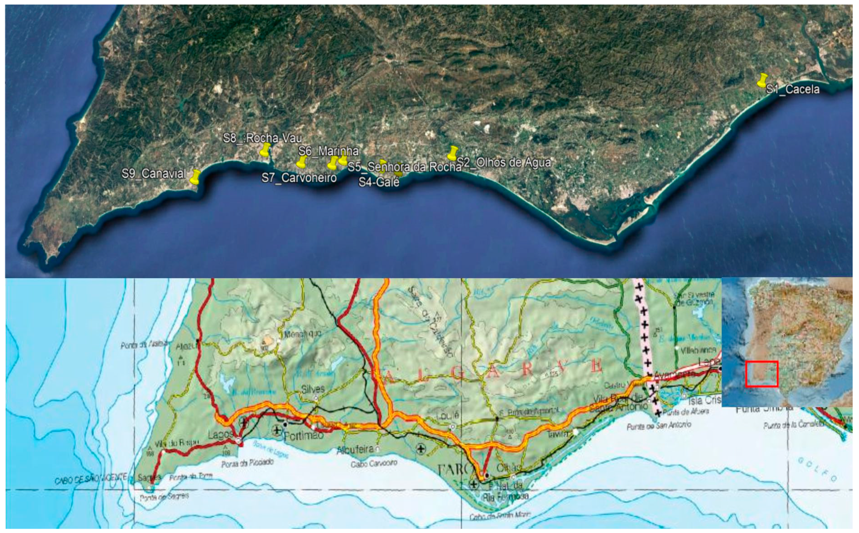
,  ,
, 
Abstract
:1. Introduction
2. Geological and Geomorphological Setting
2.1. Geological Setting
- (a)
- Lagos-Portimão Formation (Burdigalian to Serravallian). This Formation outcrops in the coastal cliffs between Lagos and Olhos de Água, consisting of yellowish to pinky, and is very fossiliferous (biocalcarenites with mollusks, bryozoans, echinoids, fishes, crocodiles and cetaceans). The unit presents several internal disconformities that are generally difficult to follow in the terrain and holds angular unconformity, disconformity or paraconformity contacts with the Carboniferous, Jurassic and Cretaceous rocks. Three types of facies were described [9]: (1) fossiliferous sandstone (FS) with bivalves, bryozoans, irregular echinoderms (Clypeaster), heterosteginids, gastropods, starfish and corals, representing the transgressive system tract or the early highstand system tract (shelf, depth 75–90 m); (2) coarse skeletal rudstone (SR) with lithified skeletal grains, balanids, coralline algae, pectinids and ostreids representing the transgressive system tract (mid-shelf, depth 50–75 m) and rhodolith rudstone (RR) with siliciclastic sand, spherical rhodoliths (5 cm), bivalves and bryozoan representing the photic zone protected from massive swell (inner shelf, 35–50 m).
- (b)
- Sandstones and fine sandstones unit (Lower Tortonian). This unit, also called “Laminated Sands”, overlays the Lagos-Portimão Formation by a regional disconformity. It represents a significant sedimentary shift from carbonate to siliciclastic lithologies. At the Rocha beach, the lowest layer is a conglomerate with phosphate clasts and glauconite.
- (c)
- Cacela Formation (Upper Tortonian to Messinian). Outcropping mainly in the eastern sector of the Algarve (Cacela); it consists of conglomerates and limestones with quartz pebbles at the base, passing upwards to carbonate or clayey sands, and it is sometimes enriched in glauconite and bears hundreds of species of mollusks. This unit lies in angular unconformity on the Triassic and in disconformity with the Lagos-Portimão Formation or with the sandstones and fine sandstones unit.
2.2. Geomorphological Setting
3. Materials and Methods
4. Results and Discussion
4.1. Geosites Description and Geoheritage Evaluation
4.2. Three-Dimensional Virtual Itinerary with Augmented Reality
5. Conclusions
Supplementary Materials
Author Contributions
Funding
Acknowledgments
Conflicts of Interest
References
- Oliveira, S.; Moura, D.; Boski, T.; Horta, J. Coastal paleokarst landforms: A morphometric approach via UAV for coastal management (Algarve, Portugal case study). Ocean. Coast. Manag. 2019, 167, 245–261. [Google Scholar] [CrossRef]
- Pais, J.; Cunha, P.P.; Pereira, D.; Legoinha, P.; Dias, R.; Moura, D.; Brum, A.; Kullberg, J.C.; González-Delgado, J.A. The Paleogene and Neogene of Western Iberia (Portugal): A Cenozoic Record in the European Atlantic Domain. Springer Briefs Earth Sci. 2012, 1, 1–138. [Google Scholar]
- Martínez-Graña, A.; González-Delgado, J.; Pallarés, S.; Goy, J.; Civis Llovera, J. 3D virtual itinerary for education using Google Earth as a tool for recovery of the geological heritage of Natural Areas: Application in the “Las Batuecas Valley” Nature Park (Salamanca, Spain). Sustainability 2014, 6, 8567–8591. [Google Scholar] [CrossRef] [Green Version]
- Brilha, J. Inventory and quantitative assessment of geosites and geodiversity sites: A review. Geoheritage 2016, 8, 119–134. [Google Scholar] [CrossRef] [Green Version]
- Martínez-Graña, A.M.; Goy, J.L.; Cimarra, C. 2D to 3D geologic map transformation using virtual globes, flight simulators, and their applications in the analysis of geodiversity in natural areas. Environ. Earth Sci. 2015, 73, 8023–8034. [Google Scholar] [CrossRef]
- Terrinha, P.; Rocha, R.; Rey, J.; Cachão, M.; Moura, D.; Roque, C.; Martins, L.; Valadares, V.; Cabral, J.; Azevedo, M.R.; et al. A Bacia do Algarve: Estratigrafia, Paleogeografia e tectónica. In Geologia de Portugal no Contexto da Ibéria; Dias, R., Araújo, A., Terrinha, P., Kullberg, J.C., Eds.; Sociedade Geológica de Portugal & Universidade de Évora: Évora, Portugal, 2006; pp. 247–316. [Google Scholar]
- Reynard, E.; Brilha, J. (Eds.) Geoheritage: Assessment, Protection, and Management; Elsevier: New York, NY, USA, 2017. [Google Scholar]
- Antunes, M.T.; Pais, J. The Neogene and Quaternary of Algarve. Ciências Da Terra 1992, 2, 57–72. [Google Scholar]
- Antunes, M.T.; Elderfield, H.; Legoinha, P.; Pais, J. The Neogene of Algarve. In González-Delgado, Sierro & Pais (Coord.): The Guadalquivir Basin and Algarve, Field Trip Guide 2; IV RCANS Congress: Salamanca, Spain, 1997. [Google Scholar]
- Pais, J.; Legoinha, P.; Elderfield, H.; Sousa, L.; Estevens, M. The Neogene of Algarve (Portugal). Ciências Da Terra (UNL) 2000, 14, 277–288. Available online: http://hdl.handle.net/10362/4720 (accessed on 11 December 2020).
- Porta, J. Distribución geográfica y cronoestratigráfica de Palliolum (Lissochlamys) excisum en España. Acta Geol. Hisp. 1979, 14, 370–374. [Google Scholar]
- Moura, D.; Albardeiro, L.; Veiga-Pires, C.; Boski, T.; Tigano, E. Morphological features and processes in the central Algarve rocky coast (South Portugal). Geomorphology 2006, 81, 345–360. [Google Scholar] [CrossRef] [Green Version]
- Zazo, C. El problema del limite Neógeno-Cuaternario del S y SE de España. Trab. Sobre Neógeno-Cuatern. 1979, 9, 65–72. [Google Scholar]
- Zazo, C.; Goy, J.L.; Hoyos, M.; Meco, J.; Usera, J.; García Vicente, J.; Galván, J.; Aguirre, E. El corte de Puerto Real y el problema del limite Plio-Pleistoceno en la Bahía de Cádiz. Trab. Sobre Neógeno-Cuatern. 1977, 6, 319–336. [Google Scholar]
- Moura, D.; Boski, T.; Dias, R. Sedimentacao detritica durante o Pliocenico e pleistocénico no Algarve Central. Comun. Inst. Geol. E Min. 1998, 84, A177–A180. [Google Scholar]
- Dias, R.P.; Cabral, J. Interpretation of recent structures in an area of cryptokarst evolution—Neotectonic versus subsidence genesis. Geodinámica Acta 2002, 15, 233–248. [Google Scholar] [CrossRef]
- Moura, D.; Gabriel, S.; Jacob, J. Coastal morphology along the Central Algarve rocky coast: Driver mechanisms. J. Coast. Res. 2011, SI61, 790–794. [Google Scholar]
- Nicod, J. Les Karsts sous couverture (sableuse, argileuse, et/ou détritique) en France, d’ après des trabaux récents. Cuad. De Sección. Hist. 1992, 20, 165–185. [Google Scholar]
- Cáceres, L.M.; Rodriguez Vidal, J.; Rodriguez Ramírez, A.; Cantano, M. Procesos karsticos en Ia formaci6n Calcarenita de Niebla (Huelva). Geogaceta 1997, 21, 43–46. [Google Scholar]
- Marsico, A.; Selleri, G. The solution pipes. In Puglia 2003-Final Conference Quaternary Coastal Morphology and Sea Level Changes; IGCP 437 Project; Mastronuzzi, G., Sanso, P., Eds.; Elsevier: Amsterdam, The Netherlands, 2003; pp. 113–115. [Google Scholar]
- Cabero, A.; Lario, J.; Zazo, C.; Goy, J.L.; Dabrio, C.J.; Borja, F.; Roquero, E.; Silva, P.G.; García-Blázquez, A.; Bardají, T.; et al. Geomorphologic setting and 1755? Tsunami deposits at Cape Trafalgar. In Palaeoseismicity and Active Tectonics during the Quaternary in the Gibraltar Strait (Betic Cordillera, South Spain); IGME: Madrid, Spain, 2009; pp. 74–84. [Google Scholar]
- De Waele, J.; Mucedda, M.; Montanaro, L. Morphology and origin of coastal karst landforms in Miocene and Quaternary carbonate rocks along the central-western coast of Sardinia (Italy). Geomorphology 2009, 106, 26–34. [Google Scholar] [CrossRef]
- De Paor, D.; Whitmeyer, S.J. Geological and geophysical modelling on virtual globes using KML, COLLADA and Javascript. Comput. Geosci. 2011, 37, 100–110. [Google Scholar] [CrossRef]
- De Miguel, D.; Brilha, J.; Alegret, L.; Arenillas, I.; José, A.A.; Gilabert, V.; Strani, F.; Valenciano, A.; Villas, E.; Azanza, B. Linking geological heritage and geoethics with a particular emphasis on palaeontological heritage: The new concept of ‘palaeontoethics’. Geoheritage 2021, 13, 69. [Google Scholar] [CrossRef]
- García Cortés, A.; Carcavilla, L.; Díaz-Martínez, E.; Vegas, J. Documento Metodológico para la Elaboración del Inventario Español de Lugares de Interés Geológico (IELIG); Instituto Geológico y Minero de España: Madrid, Spain, 2018; 61p. [Google Scholar]
- Martínez-Graña, A.; Goy, J.; Cimarra, C. Virtual tour of geological heritage: Valourising geodiversity using Google Earth and QR code. Comput. Geosci. 2013, 61, 83–93. [Google Scholar] [CrossRef]
- Kroeger, K.F.; Reuter, M.; Forst, M.H.; Breisig, S.; Hartmann, G.; Brachert, T.C. Eustasy and sea water Sr composition: Application to highresolution Sr-isotope stratigraphy of Miocene shallow-water carbonates. Sedimentology 2007, 54, 565–585. [Google Scholar] [CrossRef]
- Martínez-Graña, A.M.; Bajo, I.; González-Delgado, J.A.; Cárdenas-Carretero, J.; Abad, M.; Legoinha, P. Virtual geo-resources applied to the palaeontological heritage in Sevilla (Guadalquivir Neogene basin, Spain). Geoheritage 2018, 10, 473–482. [Google Scholar] [CrossRef]
- Martínez-Graña, A.; Goy, J.L.; González-Delgado, J.A.; Cruz, R.; Sanz, J.; Bustamante, I. 3D Virtual itinerary in the Geological Heritage from Natural Parks in Salamanca-Ávila-Cáceres, Spain. Sustainability 2019, 11, 144. [Google Scholar] [CrossRef] [Green Version]
- González-Delgado, J.A.; Andrés, I.; Sierro, F.J. Late Neogene Molluscan faunas from NE Atlantic (Portugal, Spain, Morocco). Geobios 1995, 28, 459–471. [Google Scholar] [CrossRef]
- Civis, J.; Pais, J.; González-Delgado, J.A.; Legoinha, P. Síntesis paleontológica del Tortoniense Superior de Cacela (Algarve, Portugal). Resumos das XVI Jornadas de la Sociedad Española de Paleontología/I Congresso Ibérico de Paleontologia; Universidade de Évora: Évora, Portugal, 2000; pp. 10–11. [Google Scholar]
- Santos, A. Tafonomia e Paleoicnologia do Neogénico Superior do Sector Cacela-Huelva (SE da Ibéria), University of the Algarve: Faro, Portugal, 2005; 207p, Unpublished Work.
- Santos, A.; Mayoral, E. Bioerosion versus colonization on Bivalvia: A case study from the Upper Miocene of Cacela (SE Portugal). Geobios 2008, 41, 43–59. [Google Scholar] [CrossRef]
- Martínez-Graña, A.M.; Legoinha, P.; González-Delgado, J.A.; Dabrio, C.J.; Pais, J.; Goy, J.L.; Zazo, C.; Civis, J.; Armenteros, I.; Alonso-Gavilán, G.; et al. Augmented Reality in a Hiking Tour of the Miocene Geoheritage of the Central Algarver Cliffs (Portugal). Geoheritage 2017, 9, 121–131. [Google Scholar] [CrossRef]
- Dabrio, C.J.; González-Delgado, J.A.; Armenteros, I.; Civis, J.; Pais, J.; Alonso-Gavilán, G.; Legoinha, P. Facies changes and paleogeographical implications in the Serravallian of the Lagos-Portimao Formation (Praia da Rocha, S Portugal). Geo-Temas 2008, 10, 131–134. [Google Scholar]
- Armenteros, I.; Dabrio, C.J.; Legoinha, P.; González-Delgado, J.A.; Martínez-Graña, A.; Alonso-Gavilán, G.; Civis, J.; Pais, J. Facies and sequence analysis of Miocene open-shelf warm-temperate carbonates in Portimão (Lagos-Portimão Formation, Portugal). Facies 2019, 65, 33. [Google Scholar] [CrossRef]
- Da Silva, C.M.; Cachao, M.; Rebelo, A.C.; Johnson, M.E.; Baarli, B.G.; Santos, A.; Mayoral, E. Paleoenvironment and taphonomy of lower Miocene bivalve and macroid assemblages: The Lagos Biocalcarenite (Lagos-Portimao Formation, southern Portugal). Facies 2019, 65, 6. [Google Scholar] [CrossRef]


| S1 | S2 | S3 | S4 | S5 | S6 | S7 | S8 | S9 | SC | D | T | |
|---|---|---|---|---|---|---|---|---|---|---|---|---|
| Representativeness | 4 | 4 | 2 | 2 | 1 | 4 | 1 | 4 | 4 | 30 | 5 | |
| Character type locality | 2 | 1 | 1 | 1 | 0 | 1 | 1 | 1 | 1 | 10 | 5 | |
| Degree of scientific knowledge about place | 4 | 2 | 4 | 4 | 1 | 1 | 1 | 4 | 4 | 15 | ||
| State of conservation | 1 | 4 | 4 | 4 | 4 | 4 | 4 | 4 | 4 | 10 | 5 | |
| Viewing conditions | 1 | 4 | 4 | 4 | 4 | 4 | 4 | 4 | 4 | 10 | 5 | |
| Rarity | 2 | 2 | 1 | 1 | 0 | 0 | 1 | 1 | 1 | 15 | 5 | |
| Geological diversity | 1 | 2 | 2 | 2 | 2 | 2 | 1 | 2 | 2 | 10 | 10 | |
| Learning objectives/educational use | 2 | 1 | 4 | 4 | 1 | 2 | 0 | 1 | 1 | 20 | ||
| Logistics infrastructure | 4 | 4 | 4 | 4 | 4 | 4 | 4 | 4 | 4 | 15 | 5 | |
| Population density | 2 | 2 | 2 | 2 | 2 | 2 | 2 | 2 | 2 | 5 | 5 | |
| Accessibility | 1 | 0 | 2 | 4 | 4 | 4 | 4 | 4 | 0 | 10 | 10 | |
| Intrinsic fragility | 1 | 1 | 2 | 1 | 2 | 4 | 2 | 2 | 2 | 5 | 15 | |
| Association with elements nature/culture heritage | 2 | 1 | 2 | 1 | 2 | 2 | 2 | 1 | 1 | 5 | 5 | |
| Beauty/spectacularity | 1 | 2 | 2 | 2 | 2 | 4 | 2 | 1 | 1 | 5 | 20 | |
| Informative content/use | 0 | 0 | 2 | 2 | 2 | 2 | 2 | 0 | 0 | 15 | ||
| Potential for activities tourism/recreation | 1 | 1 | 2 | 4 | 2 | 2 | 2 | 1 | 1 | 5 | ||
| Proximity to recreational areas | 2 | 4 | 4 | 4 | 4 | 4 | 4 | 4 | 4 | 5 | ||
| Socioeconomic environment | 0 | 0 | 0 | 0 | 0 | 0 | 0 | 0 | 0 | 10 | ||
| Total | 31 | 35 | 44 | 46 | 37 | 46 | 37 | 40 | 36 | 100 | 100 | 100 |
| S1 | S2 | S3 | S4 | S5 | S6 | S7 | S8 | S9 | |
|---|---|---|---|---|---|---|---|---|---|
| Scientific interest | 260 | 290 | 245 | 245 | 145 | 245 | 160 | 305 | 305 |
| Educational interest | 200 | 200 | 280 | 305 | 235 | 285 | 245 | 250 | 190 |
| Touristic/recreational interest | 105 | 115 | 210 | 220 | 230 | 300 | 230 | 185 | 130 |
| Total | 565 | 605 | 735 | 770 | 620 | 830 | 635 | 740 | 625 |
Publisher’s Note: MDPI stays neutral with regard to jurisdictional claims in published maps and institutional affiliations. |
© 2021 by the authors. Licensee MDPI, Basel, Switzerland. This article is an open access article distributed under the terms and conditions of the Creative Commons Attribution (CC BY) license (https://creativecommons.org/licenses/by/4.0/).
Share and Cite
Martínez-Graña, A.; Legoinha, P.; Goy, J.L.; González-Delgado, J.A.; Armenteros, I.; Dabrio, C.; Zazo, C. Geological-Geomorphological and Paleontological Heritage in the Algarve (Portugal) Applied to Geotourism and Geoeducation. Land 2021, 10, 918. https://doi.org/10.3390/land10090918
Martínez-Graña A, Legoinha P, Goy JL, González-Delgado JA, Armenteros I, Dabrio C, Zazo C. Geological-Geomorphological and Paleontological Heritage in the Algarve (Portugal) Applied to Geotourism and Geoeducation. Land. 2021; 10(9):918. https://doi.org/10.3390/land10090918
Chicago/Turabian StyleMartínez-Graña, Antonio, Paulo Legoinha, José Luis Goy, José Angel González-Delgado, Ildefonso Armenteros, Cristino Dabrio, and Caridad Zazo. 2021. "Geological-Geomorphological and Paleontological Heritage in the Algarve (Portugal) Applied to Geotourism and Geoeducation" Land 10, no. 9: 918. https://doi.org/10.3390/land10090918
APA StyleMartínez-Graña, A., Legoinha, P., Goy, J. L., González-Delgado, J. A., Armenteros, I., Dabrio, C., & Zazo, C. (2021). Geological-Geomorphological and Paleontological Heritage in the Algarve (Portugal) Applied to Geotourism and Geoeducation. Land, 10(9), 918. https://doi.org/10.3390/land10090918