A New Remote Sensing Index for Assessing Spatial Heterogeneity in Urban Ecoenvironmental-Quality-Associated Road Networks
Abstract
:1. Introduction
2. Materials and Methods
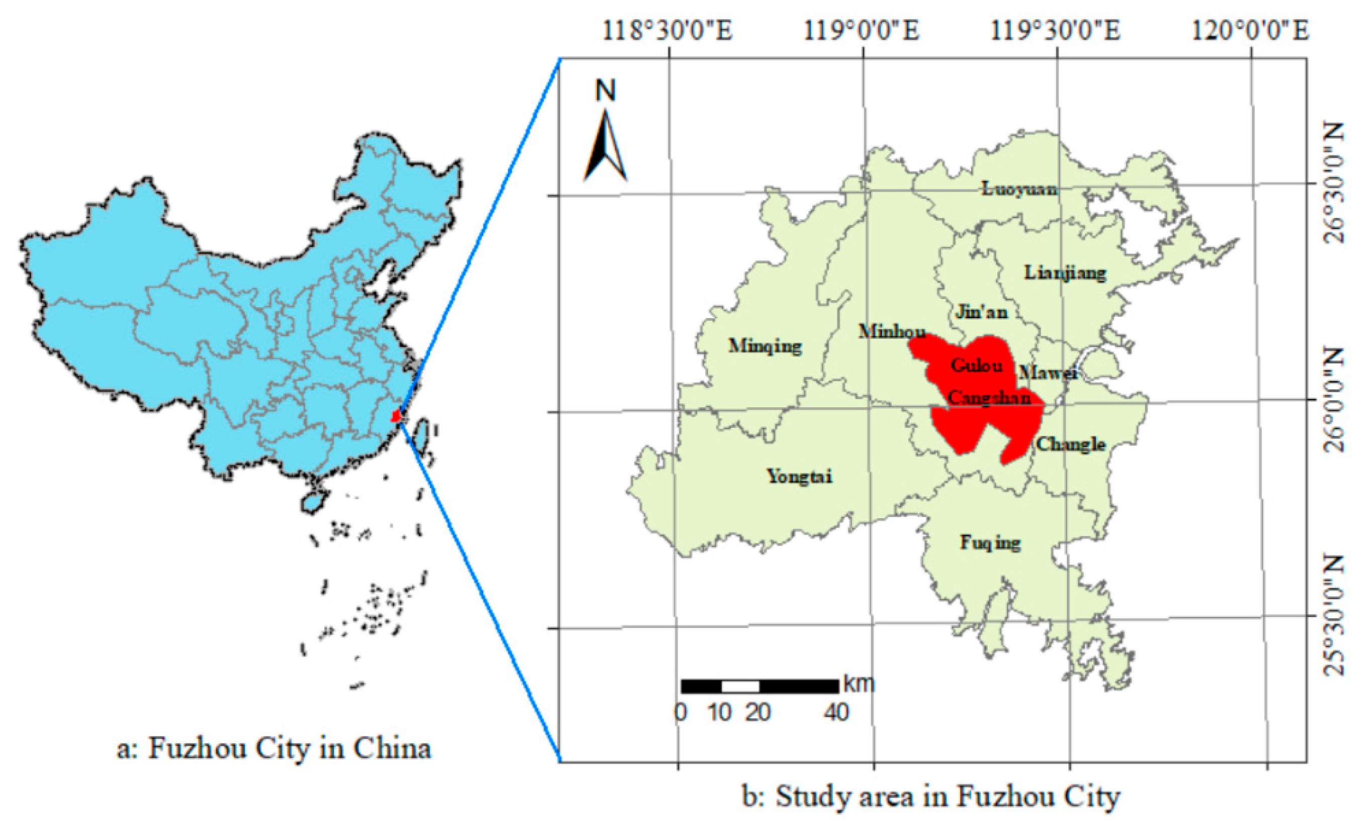
2.1. Study Area
2.2. Data Resources and Pre-Processing
2.3. Indicator Selection
2.4. Calculation of Remote-Sensing-Based Ecological Index
2.5. Estimation of Road Kernel Density
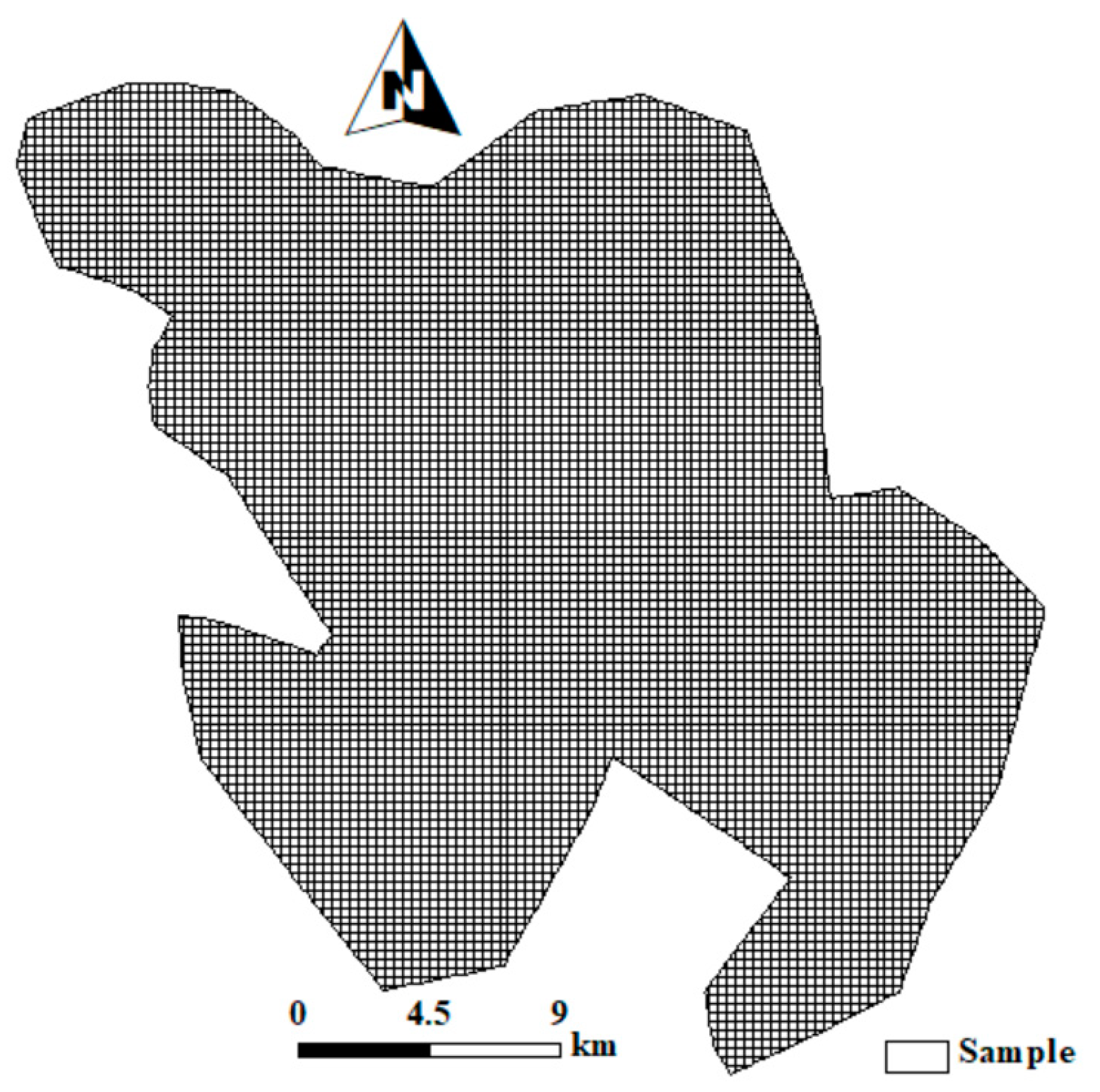
2.6. Sampling
2.7. Regression Models
3. Results
3.1. GWR and OLS Model Testing
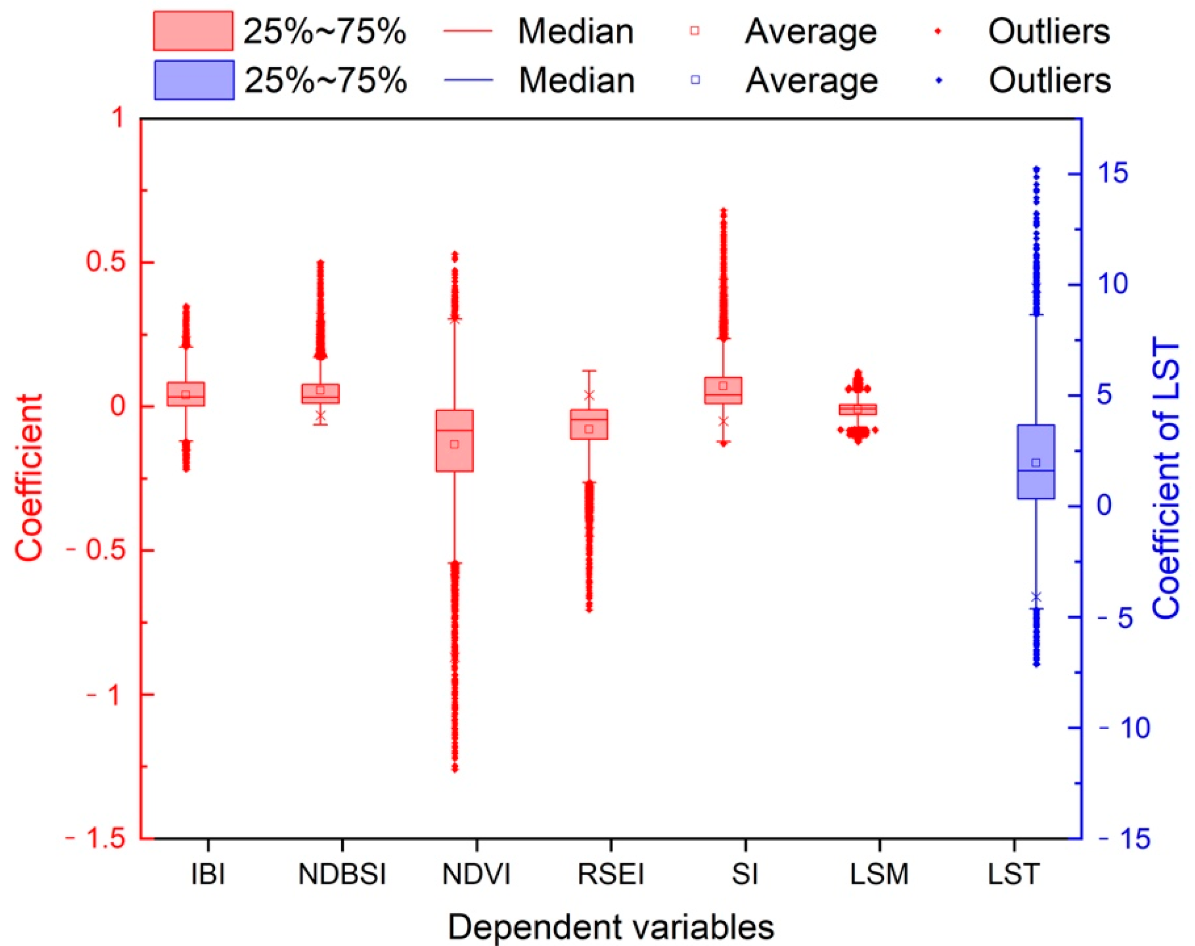
3.2. Summary of Coefficients of GWR Models
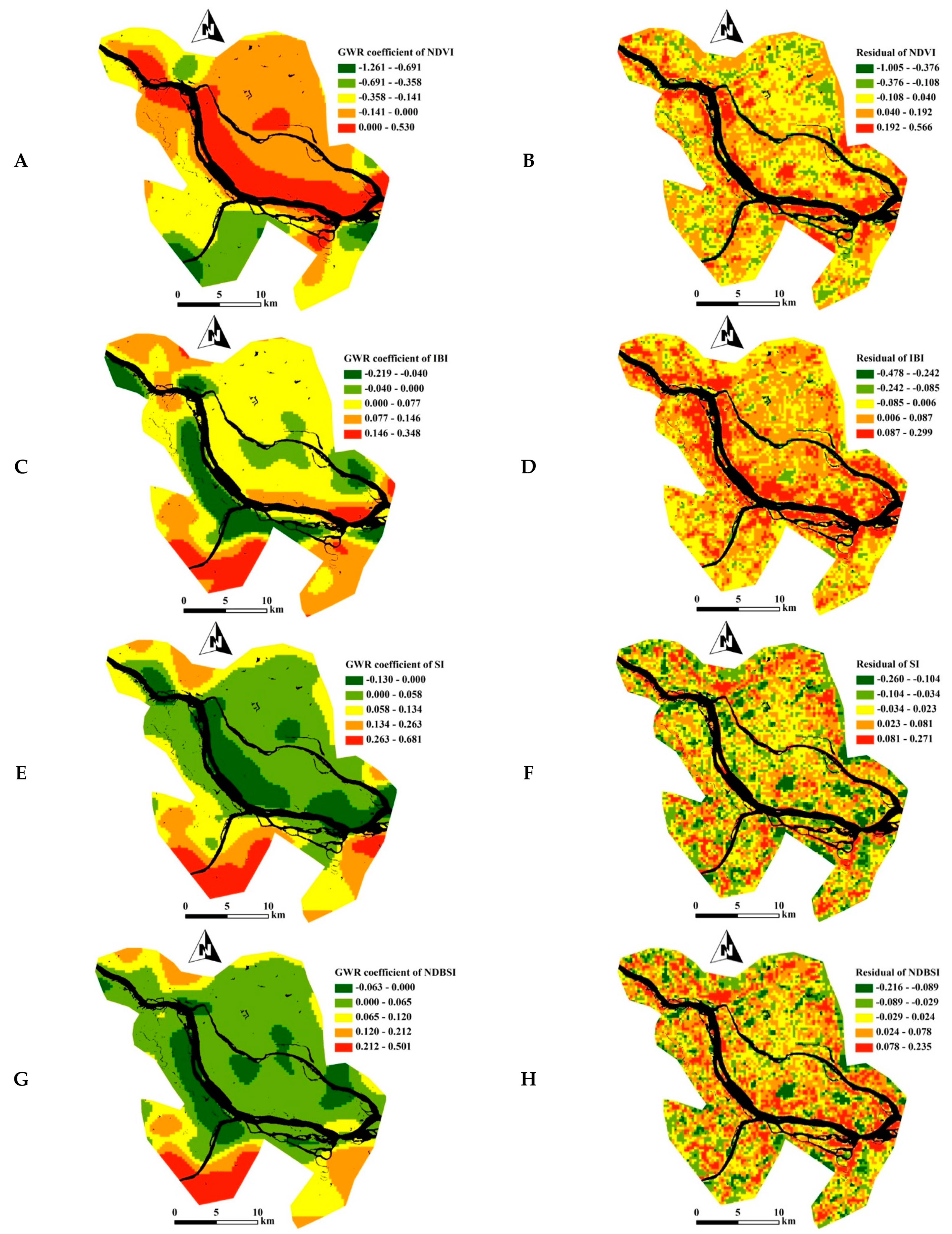
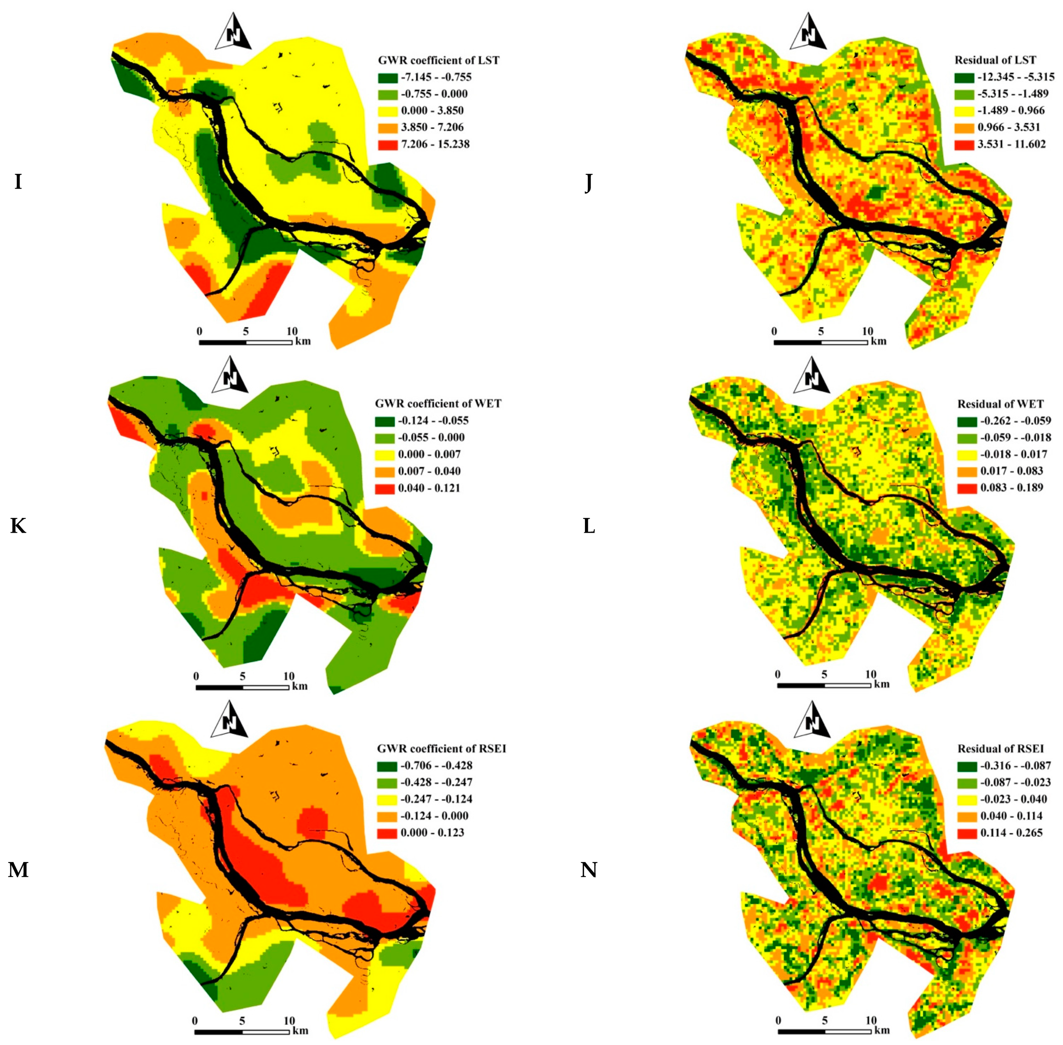
3.3. Spatial Variations in the Response of RSEI Indicators to KDR
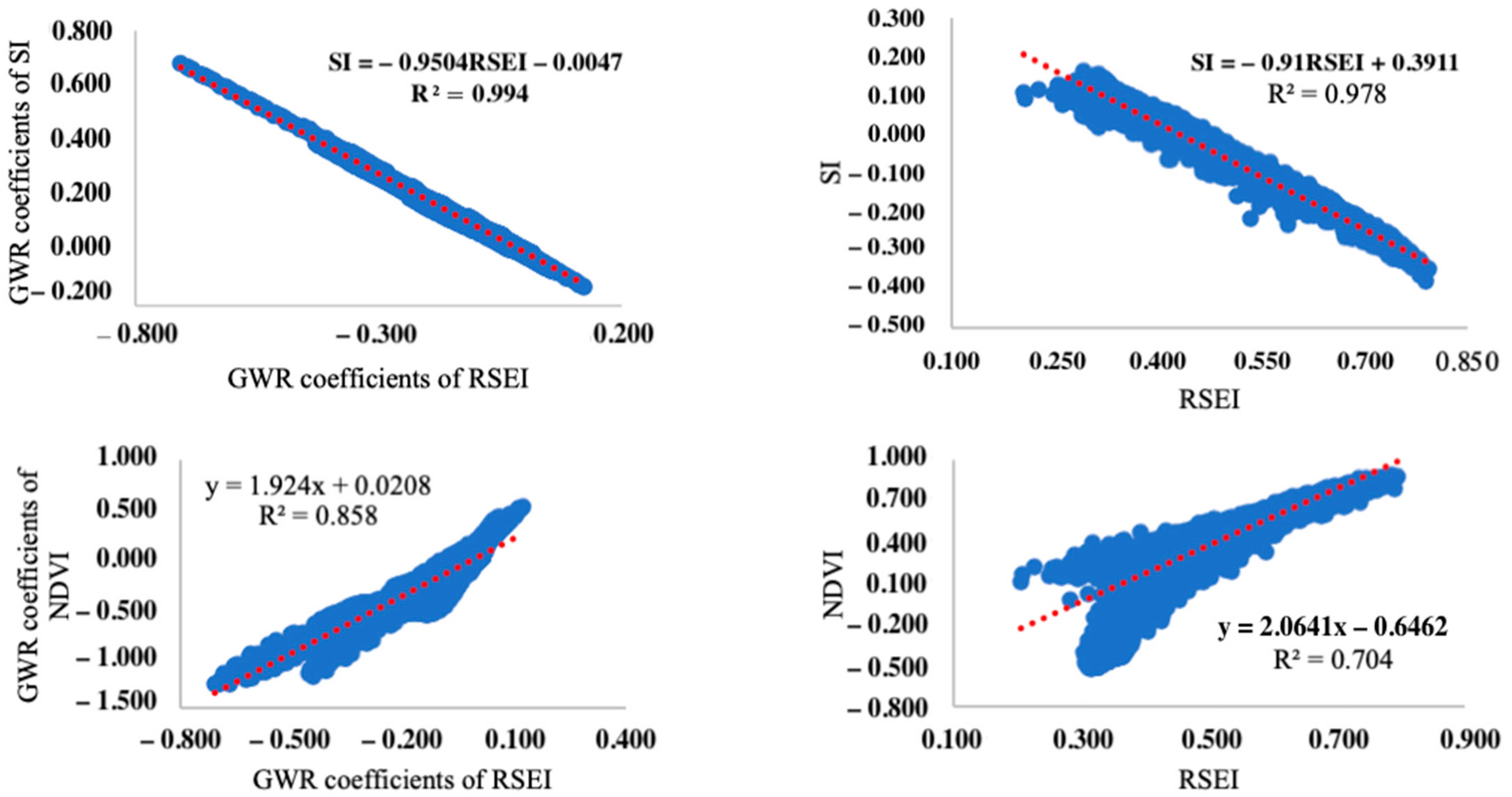
3.4. Correlation Analysis between Ecological Indicators
4. Discussion
5. Conclusions
Author Contributions
Funding
Institutional Review Board Statement
Informed Consent Statement
Data Availability Statement
Conflicts of Interest
References
- Forman, R.T.T.; Sperling, D.; Bissonette, J.A.; Clevenger, A.P.; Cutshall, C.D.; Dale, V.H.; Fahrig, L.; France, R.; Goldman, C.R.; Heanue, K.; et al. Road Ecology: Science and Solutions; Island Press: Washington, DC, USA, 2003. [Google Scholar]
- Reijnen, R.; Foppen, R.; Veenbaas, G.; Bussink, H. Disturbance by traffic of breedingbirds: Evaluation of the effect and considerations in planning and managing road corridors. Biodivers Conserv. 1997, 6, 567–581. [Google Scholar] [CrossRef]
- Li, T.; Shilling, F.; Thorne, J.; Li, F.; Schott, H.; Boynton, R.; Berry, A.M. Fragmentation of China’s landscape by roads and urban areas. Landsc. Ecol. 2010, 25, 839–853. [Google Scholar] [CrossRef] [Green Version]
- Rodney, V.D.R.; Smith, D.J.; Grilo, C. Handbook of Road Ecology; John Wiley & Sons: Hoboken, NJ, USA, 2015. [Google Scholar]
- Lin, Y.Y.; Hu, X.S.; Zheng, X.X.; Hou, X.Y.; Zhang, Z.X.; Qiu, R.Z.; Lin, J.G. Spatial variations in the relationships between road network and landscape ecological risks in the highest forest coverage region of China. Ecol. Indic. 2019, 96, 392–403. [Google Scholar] [CrossRef]
- Leonard, R.J.; Hochuli, D.F. Exhausting all avenues: Why impacts of air pollution should be part of road ecology. Front Ecol. Environ. 2017, 15, 443–449. [Google Scholar] [CrossRef]
- Hosseini, V.M.; Salmanmahiny, A.; Monavari, S.M.; Kheirkhah Zarkesh, M.M. Cumulative effects of developed road network on woodland—a landscape approach. Environ. Monit. Assess. 2014, 186, 7335–7347. [Google Scholar] [CrossRef] [PubMed]
- Zhang, L.L.; Long, R.Y.; Chen, H.; Geng, J.C. A review of China’s road traffic carbon emissions. J. Clean Prod. 2019, 207, 569–581. [Google Scholar] [CrossRef]
- Zhu, M.; Xu, J.G.; Jiang, N.; Li, J.L.; Fan, Y.M. Impacts of road corridors on urban landscape pattern: A gradient analysis with changing grain size in Shanghai, China. Landsc. Ecol. 2006, 21, 723–734. [Google Scholar] [CrossRef]
- Forman, R.T.T.; Collinge, S.K. Nature conserved in changing landscapes with and without spatial planning. Landsc. Urban Plan 1997, 37, 129–135. [Google Scholar] [CrossRef]
- Karlson, M.; Mörtberg, U.; Balfors, B. Road ecology in environmental impact assessment. Environ. Impact Asses. Rev. 2014, 48, 10–19. [Google Scholar] [CrossRef]
- Eker, M.; Coban, H.O. Impact of road network on the structure of a multifunctional forest landscape unit in southern Turkey. J. Environ. Biol. 2010, 31, 157–168. [Google Scholar] [PubMed]
- Saunders, S.C.; Mislivets, M.R.; Chen, J.Q.; Cleland, D.T. Effects of roads on landscape structure within nested ecological units of the Northern Great Lakes Region, USA. Biol. Conserv. 2002, 103, 209–225. [Google Scholar] [CrossRef]
- Reed, R.A.; Johnson-Barnard, J.; Baker, W.L. Contribution of roads to forest fragmentation in the Rocky Mountains. Conserv. Biol. 1996, 10, 1098–1106. [Google Scholar] [CrossRef]
- Karlson, M.; Mörtberg, U. A spatial ecological assessment of fragmentation and disturbance effects of the Swedish road network. Landsc. Urban Plan 2015, 134, 53–65. [Google Scholar] [CrossRef]
- Eigenbrod, F.; Hecnar, S.J.; Fahrig, L. Quantifying the road-effect zone: Threshold effects of a motorway on anuran populations in Ontario, Canada. Ecol. Soc. 2009, 14, e12839. [Google Scholar] [CrossRef] [Green Version]
- Wu, C.H.F.; Lin, Y.P.; Chiang, L.C.H.; Huang, T. Assessing highway’s impacts on landscape patterns and ecosystem services: A case study in Puli Township, Taiwan. Landsc. Urban Plan 2014, 128, 60–71. [Google Scholar] [CrossRef]
- Qi, J.D.; He, B.J.; Wang, M.; Zhu, J.; Fu, W.C. Do grey infrastructures always elevate urban temperature? no, utilizing grey infrastructures to mitigate urban heat island effects. Sustain. Soc. 2019, 46, 101392. [Google Scholar] [CrossRef]
- Honrado, J.P.; Vieira, C.; Soares, C.; Monteiro, M.B.; Marcos, B.; Pereira, H.M.; Partidario, M.R. Can we infer about ecosystem services from EIA and SEA practice? A framework for analysis and examples from Portugal. Environ. Impact Asses. 2013, 40, 14–24. [Google Scholar] [CrossRef]
- Karjalainen, T.P.; Marttunen, M.; Sarkki, S.; Rytkönen, A.M. Integrating ecosystem services into environmental impact assessment: An analytic–deliberative approach. Environ. Impact Asses. 2013, 40, 54–64. [Google Scholar] [CrossRef]
- Xu, H.Q.; Wang, M.Y.; Shi, T.T.; Guan, H.D.; Fang, C.Y.; Lin, Z.L. Prediction of ecological effects of potential population and impervious surface increases using a remote sensing based ecological index (RSEI). Ecol. Indic. 2018, 93, 730–740. [Google Scholar] [CrossRef]
- Xu, H.Q.; Wang, Y.F.; Guan, H.D.; Shi, T.T.; Hu, X.S. Detecting ecological changes with a remote sensing based ecological index (RSEI) produced time series and change vector analysis. Remote Sens. 2019, 11, 2345. [Google Scholar] [CrossRef] [Green Version]
- Hu, X.S.; Xu, H.Q. Spatial variability of urban climate in response to quantitative trait of land cover based on GWR model. Environ. Monit. Assess. 2019, 191, 194. [Google Scholar] [CrossRef]
- Cai, X.J.; Wu, Z.F.; Cheng, J. Using kernel density estimation to assess the spatial pattern of road density and its impact on landscape fragmentation. Int. J. Geogr. Inf. Sci. 2013, 27, 222–230. [Google Scholar] [CrossRef]
- United States Geological Survey. Available online: https://glovis.usgs.gov/ (accessed on 25 June 2016).
- Xu, H.Q. Modification of normalised difference water index (NDWI) to enhance open water features in remotely sensed imagery. Int. J. Remote Sens. 2006, 27, 3025–3033. [Google Scholar] [CrossRef]
- Hu, X.S.; Xu, H.Q. A new remote sensing index for assessing the spatial heterogeneity in urban ecological quality: A case from Fuzhou City, China. Ecol. Indic. 2018, 89, 11–21. [Google Scholar] [CrossRef]
- Hu, X.S.; Xu, H.Q. A new remote sensing index based on the pressure-state-response framework to assess regional ecological change. Environ. Sci. Pollut. R 2019, 26, 5381–5393. [Google Scholar] [CrossRef] [PubMed]
- Reza, M.I.H.; Abdullah, S.A. Regional Index of Ecological Integrity: A need for sustainable management of natural resources. Ecol. Indic. 2011, 11, 220–229. [Google Scholar] [CrossRef]
- Kennedy, R.E.; Andréfouët, S.; Cohen, W.B.; Gómez, C.; Griffiths, P.; Hais, M.; Healey, S.P.; Healey, E.H.; Hostert, P.; Lyons, M.B.; et al. Bringing an ecological view of change to Landsat-based remote sensing. Front. Ecol. Environ. 2014, 12, 339–346. [Google Scholar] [CrossRef]
- Malbéteau, Y.; Merlin, O.; Gascoin, S.; Gastellu, J.P.; Matter, C.; Olivera-Gierra, L.; Khabba, S.; Jarlan, L. Normalizing land surface temperature data for elevation and illumination effects in mountainous areas: A case study using aster data over a steep-sided valley in Morocco. Remote Sens. Environ. 2017, 189, 25–39. [Google Scholar] [CrossRef] [Green Version]
- Dubinin, V.; Svoray, T.; Dorman, M.; Perevolotsky, A. Detecting biodiversity refugia using remotely sensed data. Landsc. Ecol. 2018, 33, 1815–1830. [Google Scholar] [CrossRef]
- Mishra, N.B.; Crews, K.A.; Neeti, N.; Meyer, T.; Young, K.R. MODIS derived vegetation greenness trends in African Savanna: Deconstructing and localizing the role of changing moisture availability, fire regime and anthropogenic impact. Remote Sens. Environ. 2015, 169, 192–204. [Google Scholar] [CrossRef]
- White, D.C.; Lewis, M.M.; Green, G.; Gotch, T.B. A generalizable NDVI-based wetland delineation indicator for remote monitoring of groundwater flows in the Australian Great Artesian Basin. Ecol. Indic. 2016, 60, 1309–1320. [Google Scholar] [CrossRef] [Green Version]
- Healey, S.P.; Cohen, W.B.; Yang, Z.Q.; Krankina, O.N. Comparison of Tasseled Cap-based Landsat data structures for use in forest disturbance detection. Remote Sens. Environ. 2005, 97, 301–310. [Google Scholar] [CrossRef]
- Mildrexler, D.J.; Zhao, M.S.; Running, S.W. Testing a MODIS Global Disturbance Index across North America. Remote Sens. Environ. 2009, 113, 2103–2117. [Google Scholar] [CrossRef]
- Rhee, J.Y.; Im, J.; Carbone, G.J. Monitoring agricultural drought for arid and humid regions using multi-sensor remote sensing data. Remote Sens. Environ. 2010, 114, 2875–2887. [Google Scholar] [CrossRef]
- Xu, H.Q. A new index for delineating built-up land features in satellite imagery. Int. J. Remote Sens. 2008, 29, 4269–4276. [Google Scholar] [CrossRef]
- Zhao, Z.Q.; He, B.J.; Li, L.G.; Wang, H.B.; Darko, A. Profile and concentric zonal analysis of relationships between land use/land cover and land surface temperature: Case study of Shenyang, China. Energy Build. 2017, 155, 282–295. [Google Scholar] [CrossRef]
- Hu, X.S.; Zhang, L.Y.; Ye, L.M.; Lin, Y.H.; Qiu, R.Z. Locating spatial variation in the association between road network and forest biomass carbon accumulation. Ecol. Indic. 2017, 73, 214–223. [Google Scholar] [CrossRef]
- Silverman, B.W. Density Estimation for Statistics and Data Analysis; Chapman and Hall: New York, NY, USA, 1986. [Google Scholar]
- Lin, Y.Y.; Hu, X.S.; Lin, M.S.; Qiu, R.Z.; Li, B.Y. Spatial Paradigms in Road Networks and Their Delimitation of Urban Boundaries Based on KDE. ISPRS Int. J. Geo-Inf. 2020, 9, 204. [Google Scholar] [CrossRef] [Green Version]
- Cohen, W.B.; Maiersperger, T.K.; Gower, S.T.; Turner, D.P. An improved strategy for regression of biophysical variables and Landsat ETM+ data. Remote Sens. Environ. 2003, 84, 561–571. [Google Scholar] [CrossRef] [Green Version]
- Foody, G.M. Geographical weighting as a further refinement to regression modelling: An example focused on the NDVI–rainfall relationship. Remote Sens. Environ. 2003, 88, 283–293. [Google Scholar] [CrossRef]
- Jing, Y.Q.; Zhang, F.; He, Y.F.; Kung, H.; Johnson, V.C.; Muhadaisi, A. Assessment of spatial and temporal variation of ecological environment quality in Ebinur Lake Wetland National Nature Reserve, Xinjiang, China. Ecol. Indic. 2020, 110, 105874. [Google Scholar] [CrossRef]
- Fotheringham, A.S.; Charlton, M.E.; Brunsdon, C. Geographically weighted regression: A natural evolution of the expansion method for spatial data analysis. Environ. Plan. A 1998, 30, 1905–1927. [Google Scholar] [CrossRef]
- Kupfer, J.A.; Farris, C.A. Incorporating spatial non-stationarity of regression coefficients into predictive vegetation models. Landsc. Ecol. 2007, 22, 837–852. [Google Scholar] [CrossRef]
- You, W.; Zang, Z.L.; Zhang, L.F.; Li, Z.J.; Chen, D.; Zhang, G. Estimating ground-level PM10 concentration in northwestern China using geographically weighted regression based on satellite AOD combined with CALIPSO and MODIS fire count. Remote Sens. Environ. 2015, 168, 276–285. [Google Scholar] [CrossRef]
- Buyantuyev, A.; Wu, J.G. Urban heat islands and landscape heterogeneity: Linking spatiotemporal variations in surface temperatures to land-cover and socioeconomic patterns. Landsc. Ecol. 2010, 25, 17–33. [Google Scholar] [CrossRef]
- Hawbaker, T.J.; Radeloff, V.C.; Clayton, M.K.; Hammer, R.B.; Gonzalez-Abraham, C.E. Road development, housing growth, and landscape fragmentation in northern Wisconsin: 1937–1999. Ecol. Appl. 2006, 16, 1222–1237. [Google Scholar] [CrossRef] [Green Version]
- McGarigal, K.; Romme, W.H.; Crist, M.; Roworth, E. Cumulative effects of roads and logging on landscape structure in the San Juan Mountains, Colorado (USA). Landsc. Ecol. 2001, 16, 327–349. [Google Scholar] [CrossRef]
- Tian, L.; Chen, J.Q.; Yu, S.X. Coupled dynamics of urban landscape pattern and socioeconomic drivers in Shenzhen, China. Landsc. Ecol. 2014, 29, 715–727. [Google Scholar] [CrossRef]
- Forman, R.T.T.; Alexander, L.E. Roads and their major ecological effects. Annu. Rev. Ecol. Syst. 1998, 29, 207–231. [Google Scholar] [CrossRef] [Green Version]
- Yu, W.H.; Ai, T.H.; Shao, S.W. The analysis and delimitation of Central Business District using network kernel density estimation. J. Transp. Geogr. 2015, 45, 32–47. [Google Scholar] [CrossRef]
- Liu, S.L.; Dong, Y.H.; Deng, L.; Liu, Q.; Zhao, H.D.; Dong, S.K. Forest fragmentation and landscape connectivity change associated with road network extension and city expansion: A case study in the Lancang River Valley. Ecol. Indic. 2014, 36, 160–168. [Google Scholar] [CrossRef]
- McGarigal, K.S.; Cushman, S.A.; Neel, M.C.; Ene, E. FRAGSTATS v4: Spatial Pattern Analysis Program for Categorical and Continuous Maps; University of Massachusetts: Amherst, MA, USA, 2012. [Google Scholar]
- Xu, H.Q. A remote sensing urban ecological index and its application. Acta Ecol. Sin. 2012, 33, 7853–7862. [Google Scholar]
- Fotheringham, A.S.; Brunsdon, C.; Charlton, M. Geographically Weighted Regression: The Analysis of Spatially Varying Relationships; Wiley: Chichester, UK, 2002. [Google Scholar]
- Zhao, D.X.; Wang, J.; Zhao, X.Y.; Triantafilis, J. Clay content mapping and uncertainty estimation using weighted model averaging. Catena 2022, 209, 105791. [Google Scholar] [CrossRef]
| Selected Indicator | Abbreviation | Description |
|---|---|---|
| Remote-sensing-based ecological index | RSEI | A synthetic index that can assess a region’s ecoenvironmental quality, which evaluates anthropogenic pressures, environmental states, and climate responses [21]. |
| Normalized difference vegetation index | NDVI | As an indicator of the environmental state, it describes the status quo of the environment and the quality and quantity of vegetated areas [5,21,28]. |
| Index-based built-up index | IBI | An aggregated index that can rapidly extract built-up features in satellite imagery. IBI is positively correlated with LST and negatively correlated with the NDVI and the MNDWI [38]. |
| Soil index | SI | Indicates patches of bare land or sparsely vegetated ground that occur in deforested or abandoned locations across the study area [28]. |
| Normalized differential build-up and bare soil index | NDBI | Represents the pressure intensity on the environment originating from human activities [28]. |
| Land surface temperature | LST | Indicates local climatic (i.e., temperature and humidity) changes in response to environmental changes. [18,21,28,39] |
| Land surface moisture | LSM |
| Dependent Variables | Independent Variable | GWR | OLS | ||||||
|---|---|---|---|---|---|---|---|---|---|
| Adjusted R-Squared | AICc | Residual Squares | p-Value | Moran’s I | Adjusted R-Squared | AICc | p-Value | ||
| NDVI | KDR | 0.492 | −1593.980 | 364.288 | 0.001 | 0.264 | 0.042 | 3301.775 | 0.05 |
| IBI | 0.316 | −11,106.919 | 107.524 | 0.001 | 0.246 | 0.069 | −8745.447 | 0.05 | |
| SI | 0.555 | −17,968.641 | 44.592 | 0.001 | 0.218 | 0.113 | −12,639.017 | 0.05 | |
| NDBSI | 0.433 | −18,944.724 | 39.344 | 0.001 | 0.199 | 0.160 | −15,917.960 | 0.05 | |
| LST | 0.483 | 41,251.776 | 88,770.466 | 0.001 | 0.309 | 0.168 | 44,910.860 | 0.05 | |
| LSM | 0.314 | −23,242.687 | 22.670 | 0.001 | 0.250 | 0.013 | −20,447.086 | 0.05 | |
| RSEI | 0.564 | −16,837.017 | 51.558 | 0.001 | 0.213 | 0.138 | −11,557.232 | 0.05 | |
| Indicators | IBI | LST | NDBSI | NDVI | SI | LSM | RSEI | Color Chart | R2 |
|---|---|---|---|---|---|---|---|---|---|
| IBI | 1 | 0.957 ** | 0.776 ** | −0.060 ** | 0.397 ** | −0.918 ** | −0.428 ** | 0.85~0.99 | |
| LST | 0.912 ** | 1 | 0.786 ** | −0.123 ** | 0.444 ** | −0.901 ** | −0.482 ** | 0.70~0.84 | |
| NDBSI | 0.800 ** | 0.807 ** | 1 | −0.674 ** | 0.887 ** | −0.535 ** | −0.900 ** | 0.50~0.69 | |
| NDVI | 0.414 ** | 0.264 ** | −0.208 ** | 1 | −0.937 ** | −0.232 ** | 0.926 ** | −0.49~0.49 | |
| SI | 0.084 ** | 0.205 ** | 0.665 ** | −0.860 ** | 1 | −0.107 ** | −0.997 ** | −0.69~−0.50 | |
| LSM | −0.935 ** | −0.865 ** | −0.673 ** | −0.523 ** | 0.047 ** | 1 | 0.148 ** | −0.84~−0.70 | |
| RSEI | −0.136 ** | −0.275 ** | −0.697 ** | 0.840 ** | −0.989 ** | 0.011 | 1 | −0.99~−0.85 |
Publisher’s Note: MDPI stays neutral with regard to jurisdictional claims in published maps and institutional affiliations. |
© 2021 by the authors. Licensee MDPI, Basel, Switzerland. This article is an open access article distributed under the terms and conditions of the Creative Commons Attribution (CC BY) license (https://creativecommons.org/licenses/by/4.0/).
Share and Cite
Zheng, X.; Zou, Z.; Xu, C.; Lin, S.; Wu, Z.; Qiu, R.; Hu, X.; Li, J. A New Remote Sensing Index for Assessing Spatial Heterogeneity in Urban Ecoenvironmental-Quality-Associated Road Networks. Land 2022, 11, 46. https://doi.org/10.3390/land11010046
Zheng X, Zou Z, Xu C, Lin S, Wu Z, Qiu R, Hu X, Li J. A New Remote Sensing Index for Assessing Spatial Heterogeneity in Urban Ecoenvironmental-Quality-Associated Road Networks. Land. 2022; 11(1):46. https://doi.org/10.3390/land11010046
Chicago/Turabian StyleZheng, Xincheng, Zeyao Zou, Chongmin Xu, Sen Lin, Zhilong Wu, Rongzu Qiu, Xisheng Hu, and Jian Li. 2022. "A New Remote Sensing Index for Assessing Spatial Heterogeneity in Urban Ecoenvironmental-Quality-Associated Road Networks" Land 11, no. 1: 46. https://doi.org/10.3390/land11010046
APA StyleZheng, X., Zou, Z., Xu, C., Lin, S., Wu, Z., Qiu, R., Hu, X., & Li, J. (2022). A New Remote Sensing Index for Assessing Spatial Heterogeneity in Urban Ecoenvironmental-Quality-Associated Road Networks. Land, 11(1), 46. https://doi.org/10.3390/land11010046


