Article

Classification and Application of Digital Technologies in Landscape Heritage Protection

School of Landscape Architecture, Zhejiang A & F University, Hangzhou 311300, China
*
Author to whom correspondence should be addressed.
Land 2022, 11(10), 1699; https://doi.org/10.3390/land11101699
Submission received: 24 August 2022 / Revised: 27 September 2022 / Accepted: 29 September 2022 / Published: 30 September 2022

Abstract

:
The application of digital technology in the field of landscape architecture heritage protection is becoming more and more mature and complex. How to select and apply technology for the corresponding landscape architecture heritage objects has become a common problem in the direction of landscape architecture heritage protection. Taking the literature on “landscape architecture heritage protection” published in CNKI and the Web of Science Database in the last 10 years (2012–2021) as the research object, we clarify the objects of landscape architecture heritage protection and their digital technology and summarize three types of digital technologies in the field of landscape architecture heritage protection: collection and acquisition technology, storage and management technology, and dissemination and sharing technology. Secondly, the main application objects and digital methods of each technology are described by classification. Thirdly, the main application methods in the field of landscape architecture heritage protection are summarized, e.g., repair recovery and risk monitoring. Accordingly, the digital development process of landscape architecture heritage protection in recent years is discussed, and there are three main stages, data precision, information systematization, and smart management. Future studies should pay more attention to the co-building and sharing of heritage information and to the common protection of heritage entities and cultural emotions. Discussion on the classification and application of digital technology based on landscape architecture heritage protection will help to present a clear context for the research and practice of digital technology in the field of landscape architecture heritage protection and contribute to implementing the protection and management of landscape architecture heritage more pertinently and efficiently.

1. Introduction

With the continuous intersection of digital technology and landscape architecture in theory and practice in recent years, its application scope has gradually extended to multiple research directions, such as spatial information collection [1], parametric design [2,3], landscape analysis and assessment [4,5], landscape simulation, and visualization [6,7]. As a result, digital technology is becoming a hot topic in the field of landscape architecture [8,9].
Landscape architecture heritage protection is an important research direction of landscape architecture. The Demonstration Report on Adding Landscape Architecture as the First Level Discipline pointed out the content of landscape architecture heritage protection: “Heritage protection mainly studies world natural heritage, cultural heritage, mixed heritage, heritage cultural landscape, scenic spots, traditional gardens, native landscape protection, etc. [10]”. In 1992, the World Heritage Committee held the 16th World Heritage Congress and adopted the concept of “cultural landscape”: this refers to landscapes designed and created intentionally by man, organically evolved landscapes, and associative cultural landscapes [11]. Scenic spots and traditional gardens belong to the cultural landscape heritage forms in China’s landscape architecture system [12]. Meanwhile, the protection and renewal of historical centers such as historical blocks, towns, and cities are also related to the continuation and development of the culture of old cities [13]. The Recommendation on the Historic Urban Landscape by UNESCO states that cultural landscapes entered the domain of urban historical heritage protection for the first time on 10 November 2011, and have become a new way to lead the historical heritage protection of cities [14]. Based on the above views and Lin Guangsi’s discussion in The Field and Evolution of Landscape Architecture Heritage Protection [15], it can be concluded that the main types of landscape architecture heritage protection include cultural landscapes, natural heritage, and historical urban landscapes ①.
The question of how to use digital technology to protect the heritage of landscape architecture has been widely investigated by scholars. Fadli thinks that the data capture and management of heritage structures can be effectively elaborated through digitized means [16]. Marra believes that the protection of artistic and cultural heritage is a major challenge due to its peculiarities and its exposure to significant natural hazards, and digital technologies offer many solutions [17]. Cheng et al. concluded that “digital humanity”, which is suitable for landscape heritage conservation, has gradually become a hotspot for scholars’ attention [9]. Lin Guangsi believes that “the protection of landscape architecture heritage plays an extremely important role in the protection of immovable heritage [15]”. Chen et al. determined that “innovative use of digital technology to protect and manage heritage landscape is the research hotspot in contemporary landscape architecture and heritage circles [18]” and began to use digital technology to carry out research on the spatial pattern recognition of heritage landscapes [18,19]. At the same time, a large number of digital technologies related to heritage protection have emerged in the field of landscape architecture, such as three-dimensional technology [20], artificial intelligence [21,22], BIM [3], virtual reality [23], and so on. However, there is a lack of systematic classification and sorting of corresponding technologies compared with other cultural heritage protection areas [24] ②.
In this paper, we categorize and summarize digital technologies by analyzing relevant literature in the field of landscape architecture heritage protection published in the past 10 years (2012–2021). Subsequently, the application and development trend of digital technology in the field of landscape architecture is explored. Hopefully, different types of landscape architecture heritage can be protected more effectively, and this research will provide a reference for the application of digital technology in the field of landscape architecture heritage protection.

2. Methodology

This study used literature review and bibliometrics methods to identify and sort the research and practical results regarding digital landscape architecture heritage protection published in the China National Knowledge Infrastructure (CNKI) and Web of Science (WoS) from 2012 to 2021.
There are three main research steps included in this study:
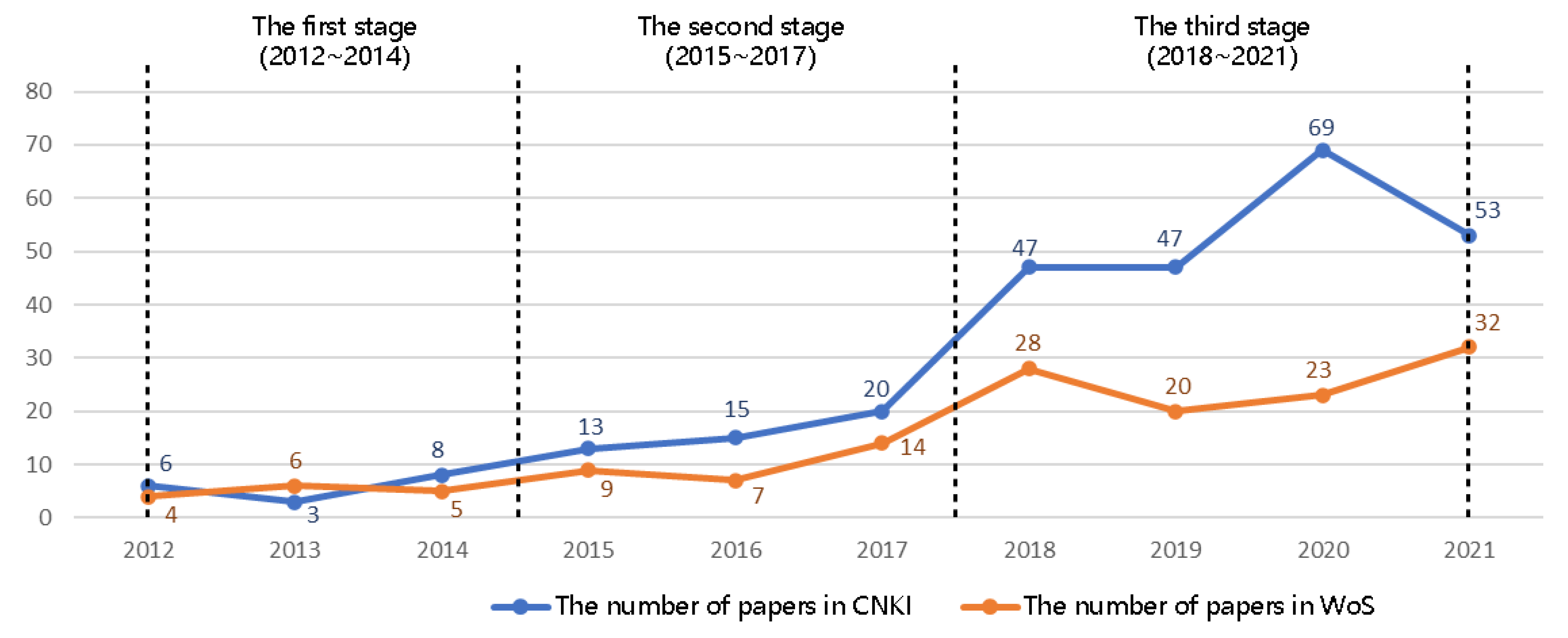
  • Literature search. The WoS database and CNKI database were searched with the keywords “digital landscape heritage” and “Digital Heritage protection”.
  • Literature processing and screening. By screening the search results of the database and eliminating papers that were not consistent with the research theme of this paper, we obtained 429 papers in total. Among them, 281 papers were obtained from the CNKI database, and 148 papers were obtained from the WoS database.
  • Data analysis. Firstly, the software Citespace was used to conduct a quantitative analysis of keywords co-occurrence and keyword clustering of the literature, and then we drew the related knowledge graph. Secondly, the popular digital technologies in the field of landscape architecture heritage protection were classified using Excel, and the digital methods and applications for different heritage protection objects were summarized. Thirdly, according to the time sequence analysis of keyword co-occurrence clustering and the timeline diagram of keywords, we analyzed the hot topics and digital technologies of landscape architecture heritage protection over the last 10 years. Eventually, through the analysis of the keywords emergence of digital heritage protection, combined with the relevant social backgrounds and policy theories, the application trend and development mechanism of digital technology of landscape architecture heritage protection for different heritage protection objects were analyzed and summarized.

3. Results

Over the past 10 years, the number of papers published on the research of digital landscape architecture heritage protection has continued to rise and has attracted the attention of the profession of landscape architecture. The number of publications in the two databases showed three stages of development characteristics: In the first stage (2012–2014), the number of publications was very small, with only three to eight publications (0.70–1.86% of the total number of studies). In the second stage (2015–2017), the number of publications in the two databases increased slowly from 9 to 20 (2.10–4.66%), and the number of publications in the CNKI database was larger than that in the WoS database. In the third stage (2018–2021), the number of articles published increased significantly compared with the first two stages and reached the highest in 2020 in the CNKI database, reaching 69 (16.08%), which was three times the number of articles published during the WoS database in the same year (Figure 1).
It can be seen from the keyword co-occurrence diagram (Figure 2) that after removing the keywords of landscape architecture and digital protection, the research content over the last 10 years can be divided into two categories:
(1) The object of landscape architecture heritage protection, such as ancient architecture, cultural heritage, traditional villages, historical blocks, sites, etc., can be categorized into cultural landscapes (ancient architecture, cultural heritage, traditional villages, and sites), natural heritage, and historical city landscapes (historical block);
(2) The technology of landscape architecture heritage protection can be divided into categories such as 3D laser scanning, BIM, virtual reality, 3D reconstruction, point cloud, drone, photogrammetry, oblique photography, etc.
The LLR clustering algorithm was used to conduct keyword clustering statistics, and seven clustering labels were obtained, including historical blocks, BIM, three-dimensional (3D) laser scanning, ancient village protection, virtual reality, cultural heritage, and architectural heritage (Figure 3). Among them, the clustering of the digital technology of landscape architecture heritage protection included three types, BIM technology, 3D laser scanning, and virtual reality.
By arranging the other digital technologies related to the above three types of digital technology regarding landscape architecture heritage protection (Table 1), it can be seen that the three technologies have their own emphasis directions: 3D laser scanning technology focuses on the mapping and feature extraction of heritage information, which when combined with digital mapping technology such as unmanned aerial vehicle (UAV) oblique photography, collects and obtains heritage information left by the current situation, text, image, and other sources. BIM technology focuses on the parameterized management of heritage information, and it usually combines digital information platforms, forward and reverse modeling, and other technologies to process the acquired heritage information and store it parameterized in the corresponding system for management. Virtual reality technology focuses on immersive roaming and scene interaction of heritage information, which combines 3D, VR images, augmented reality, and other technologies to disseminate and share heritage information to researchers and the public in related fields.
In summary, the three technical directions represented by these three technologies can be summarized as collection and acquisition technology of heritage data represented by 3D laser scanning, storage and management technology represented by BIM, and dissemination and sharing technology represented by virtual reality.
Consequently, after classifying all the above studies, we found that 245 studies related to the collection and acquisition technology of heritage data, 134 studies related to the classified storage and management technology of heritage data, and 131 studies pertained the dissemination and sharing technology of heritage information. According to the clustering of digital technology keywords in Citespace and the application cases of digital technology in the paper, we can determine the focus of each digital technology. Eventually, all the digital technologies involved in the literature were sorted according to the above three categories of digital technology in landscape architecture heritage protection, and the results are shown in Figure 4.

3.1. Collection and Acquisition Technology of Heritage Data

Based on the above data acquisition technology, currently, the most popular digital technologies contain 3D laser scanning technology, remote sensing (optical, acoustic, etc.), digital photogrammetry based on unmanned aerial vehicles (such as UAV oblique photography), satellite images, etc., which can be used in the acquisition and quantitative analysis of the information of the remaining elements of ancient gardens, historical blocks, and other landscape architecture heritage.
Given the different volumes and characteristics of the acquired heritage objects, different technical means were adopted accordingly. Therefore, this section will describe the element classification of different landscape architecture remains (Table 2).

3.1.1. Topography

Traditional surveying and mapping methods require a lot of time in the face of complex topography, and there is a big difference between the data and the real geographical environment. Using topographic and lithologic maps and satellite images, GIS databases can be created to analyze the geomorphic features of mountain areas and realize digital maps [25]. Considering that a single high-resolution terrain (HRT) technology is limited by complex terrain, terrestrial laser scanning (TLS), and aerial/terrestrial structure from motion (SfM) ④, data are fused to obtain a digital terrain model that accurately reflect the true surface roughness of the platform system [26]. More complex landforms, such as the cone-shaped karst landscapes in Libo, Guizhou province, are recorded through multi-source data such as optical remote sensing images and digital elevation models based on the DeepLab V3+ network deep learning (DL) method [27]. Meanwhile, digital technology can also study the distribution and interaction of different rural settlements [28], as well as the interaction between buildings and agricultural and forestry land [29]. Lidar and remote sensing image data are also applicable to the Arctic landscape with few traces of human activity [30]. Modern detailed digital elevation models combined with old images are used to obtain 3D glacier boundaries from a single image to show the spatial and temporal changes of the glacier region [31].

3.1.2. Rockery

Regarding rockeries and stones, an important part of ancient Chinese gardens, it is usually difficult to accurately measure their exterior contours for clear expression of the modeling complex; however, 3D scanning technology has comprehensive advantages in this aspect. In recent years, many scholars have built digital three-dimensional models based on the spatial information of rockeries, such as rockeries in the Huanxiu Villa Garden [32], rockeries in the Couple’s Garden [33], and big rockeries in the Yuyuan Garden [19], and have carried out quantitative identification and analysis of their spatial characteristics.

3.1.3. Architecture

For the architecture in gardens, digital technology can provide data support for feature analysis and research in terms of materials, periods, types, and other aspects of the architecture.
Considering some unique building materials, scanning electron microscopy [34] can be used to study the characterization of building materials, weathering mechanisms, etc., and to classify building elements based on images [35]. For example, in view of the unique wall texture of the Jiarong Tibetan stone building in Xisuo Village, researchers conducted field investigations and sampling combined with digital processing technology, such as computational models and the ultrasonic pulse velocity method, to carry out quantitative analysis, summarizing the variation rule of wall texture [36].
Digital technology can summarize the features of buildings with obvious period features and extract precise digital models for research. Taking buildings in the Qing Dynasty, for instance, researchers proposed a component-driven building program modeling method, including technical details of the component library, data-driven point cloud component/model extraction, and multi-level description of component assembly [37], to carry out more precise digital modeling.
In terms of some special types of buildings and garden architecture pieces with special forms, digital technology can be used to identify and classify them, and digital modeling can be carried out by combining a variety of collection data to improve the accuracy of the model. For high-rise buildings with narrow interiors, such as ancient towers, UAV oblique photogrammetry combined with a 3D laser scanning machine is used to combine the two sets of data for digital modeling [38]. For the various types of decorative openwork window patterns in traditional gardens, an artificial volume neural network is used to obtain data, and the objects can be intelligentially classified [21].
For rock paintings, murals, and stone carvings, which are easily damaged by nature and man, remote sensing measurement technology has become the main tool for collection and recognition because of the advantages of no contact and small amounts of damage. For instance, considering rock paintings and murals with complex images and rich colors, the combination of hyperspectral remote sensing, photogrammetry, and other traditional topographic techniques can be an effective tool to identify their graphics, coloring substances, and protection states [39,40]. In terms of mausoleum stone carvings that are large, complex, and difficult to move, a digital protection scheme can be constructed using a 3D reconstruction system combined with 3D panoramic space measurement technology [41].

3.1.4. Other Types

Other remaining elements of landscape architecture heritage can be comprehensively studied by comparison through digital technology, from macro to micro, from the whole area to local space.
From the macro point of view, all the remaining elements of a certain region are compared and analyzed, and their characteristics are summarized. For example, for cultural heritage elements connected by the Silk Road, based on the Earth’s big data, obtained through data cleaning, spatial analysis, and risk assessment, the characteristics of spatial and temporal distribution, material types, characteristics of civilizations and religions, capital investment capacity, and risks can be described [42].
Furthermore, from a microscopic point of view, digital photogrammetry can be used to obtain accurate measurement data of the remaining elements in the site, such as historical roads [43] and ancient city walls [44], and build the initial high-resolution digital model. The remaining elements in books, images [45], administrative place names [46], and other materials are standardized through digital transformation and processing to form a thematic digital repository. Additionally, considering some undiscovered civilization sites, machine learning methods based on airborne laser scanning can also be used to help us detect and search [47] to establish the geological, geomorphological, and geological time background framework, which lays a foundation for the analysis of human settlements in ancient societies [48].

3.2. Storage and Management Technology of Heritage Data

In the face of the large and dense heritage data acquired above, the question remains as to how to effectively use digital means to record and store data without occupying a large number of resources so as to achieve scientific protection and management. These questions have been given new answers with the advent of the digital age (Table 3).

3.2.1. Storage

After acquiring heritage data, researchers need to design corresponding storage platforms and systems for important heritage information and retain important meta-files to ensure that these data can be reused in the future. To be more precise, BIM, big data, and other digital technologies are used to store heritage information in the cloud for permanent preservation, for instance, for the Qatar Historical Building Information Model (Q-HBIM) platform [16] and the image information network virtual cloud of temple murals in the Tibetan, Qiang, and Yi Cultural Industry Corridor [49].
In order to keep the heritage data in the database for a long time, we should not only pay attention to the design of its storage system but also combine various technologies for subsequent repair and maintenance to reduce the storage space and resource consumption on the premise of ensuring no loss of data. For example, combined with an integrated information system and historical digital twin ⑤ (HDT) technology, a laser scanner can be used to maintain and preserve heritage [17]. The iterative method of the stepwise completion of missing fragments [50], sparse modeling, ⑥ and optimization tools [51] are used to repair the data loss during scanning. The rapid reconstruction method of the dense point cloud model using a sparse autoencoder ⑦ and compressed sensing ⑧ can reduce the resources occupied by data [52].

3.2.2. Management

Researchers use a number of digital technology systems to protect and manage heritage according to the different features of the protected object. For example, HBIM for a detailed description of heritage elements, SDI for environmental factors, and repository for supplementary information are three technical systems used to quickly assess damage and vulnerability and determine conservation priorities [53]. The 4D BIM of digital restoration and the 7D BIM of registered maintenance status are combined, and the data of the two BIM are transmitted to each other for maintenance management [23]. Moreover, a digital management system based on artificial intelligence is established to carry out preventive maintenance of historical heritage [7].
At the same time, how to visualize management platforms has also become the focus of researchers. The following are cases in point: the Geo-Memories system for visualization of landscape history, environment, and geographic spatial changes, which was developed in Italy [54]; the Nanjing Ming City Wall three-dimensional visualization management system platform [55], the Shanghai historical building information management platform [56], etc.

3.3. Dissemination and Sharing Technology of Heritage Information

With the increasing integration of digital technology and heritage protection, heritage data and results have been gradually shared with researchers and the public in other fields through network communication platforms in recent years, which contribute to promoting and strengthening the dissemination and sharing of heritage information.
That is to say, digital reconstruction is used to simulate sites, urban landscapes, and other landscape environments, which establish unique interaction channels for landscape resources and provide a new way for the public to experience heritage. For instance, realistic virtual technology can simulate not only natural terrain by topography generation and editing to create an immersive environment for the public [19] but also 3D virtual reconstruction of historical urban landscapes [57]. Furthermore, social media big data can be used to analyze the characteristics of urban landscapes [58] to determine landscape value, and different projects developed by the augmented reality technology layer (layer such as mapping, digital terrain model, etc.) in real-time geographic resources [59] can be used to evaluate the performance of cultural landscapes to create lifelike, interactive experiences to open up these sites to the world [60]. Moreover, holographic technology has also become an important way for the public to experience heritage [61], and the application of various game engines also provide channels for data experience [62], which provides a new way for tourism development of heritage sites and opens up new operation modes.

4. Discussion

From the above three categories of technology, it can be seen that the digital technology applied in landscape architecture heritage protection is flourishing and developing, and it presents a trend of diversification. Furthermore, various technical studies are closely related, so the same research problem usually requires a variety of technologies to solve the issues together. As a result, based on the above analysis of digital technology, this paper summarizes the application of digital technology in the conservation of landscape architecture heritage as follows and discusses its research trend.

4.1. Application of Digital Technology in Landscape Architecture Heritage Protection

It can be seen from the literature that in the past 10 years, the application of digital technology in the field of landscape architecture heritage protection has mainly focused on two aspects: the repair recovery of landscape architecture heritage and the risk monitoring of the heritage environment (Table 4).

4.1.1. Repair Recovery

The restoration of landscape architecture heritage mainly involves collection and acquisition technologies such as 3D scanning technology and UAV oblique photography technology, storage and management technologies such as BIM, and dissemination and sharing technologies such as virtual reality and artificial intelligence. In view of the existing landscape architecture heritage, many of them are damaged to varying degrees due to improper protection. For this reason, digital technology can obtain the existing data of the heritage and then restore it with text and image data to show the original historical appearance of the landscape architecture heritage. Applications used in recent years in the repair or recovery of landscape architecture heritage are as follows:
In terms of landscapes that have been destroyed or hidden by human beings, assessment and discussion can be carried out to reconstruct ancient landscapes by combining various data, including historical maps, written archives, digital terrain models, and image sources [63]. Furthermore, in view of the restoration of historic buildings that were damaged, we can analyze the information of the site with the help of 3D scanning, augmented reality technology, artificial intelligence study methods, etc., to restore the historical forms of the damaged buildings. Taking several cases of research in recent years, for the former residences of celebrities and historical blocks, using 3D laser scanning and BIM, digital restoration and protection can be realized through the Internet of Things platform, such as Duan Qirui’s former residence [64], Guo Moruo’s former residence [65], etc. For national architectures built using wood, vulnerable to natural wind and rain erosion and man-made destruction, we can combine augmented reality and 3D models and input the data to unity to develop the data, creating a true AR environment, such as the digital protection of architecture of Dong Nationality [66]. Equally, based on the deep learning convolution neural network (CNN) heritage protection framework of virtual reality, the blurred images of the old times can be repaired in order to restore the original historical appearance and achieve the purpose of restoration, such as the restoration of Li Nationality boat houses in Hainan Province in China [22].
Additionally, considering mausoleum and archaeological sites with large damage, data modeling can be carried out based on the current topographic environment, and the damaged data can be restored and reconstructed by simulating environmental change analysis. For example, the digital ground model construction experiment was conducted to simulate the geographical landscape of the Mausoleum of the First Emperor of the Qin dynasty [67]. The UAV oblique photogrammetry project was based on the structure from motion (SfM) and multi-view stereo (MVS) algorithm and modeled the surface topography of damaged archaeological sites, obtaining dense point clouds, orthophoto images, and digital surface models (DSM), and removing the topographic data covering the changed area from the dense point clouds before implementing virtual reconstruction [68].
In addition to the disappeared garden environment, the change of the environment can be simulated by digital technology to speculate its original appearance. For example, some dry ancient river channels can be reconstructed based on X- and L-band spaceborne synthetic aperture radar (SAR) ⑨ data [38]. Moreover, for the restoration of old garden sites in Chinese landscape paintings, 3D landscape scenes of traditional Chinese paintings can be rapidly modeled based on comprehensive terrain modeling and water flow rendering algorithms; thereby, the original appearance can be restored [28].
Furthermore, concerning the damaged garden elements in the landscape garden site, 3D point cloud technology can also be used for special restoration. For example, point cloud data and 3D models were used to establish digital archives of Jiangjunya rock paintings [69] and 3D models of the Terracotta Warriors [70], which provided an important reference basis for landscape research and realized digital landscape architecture heritage protection.

4.1.2. Risk Monitoring

Risk monitoring mainly involves collection and acquisition technologies such as infrared thermal imaging and 3D laser scanning, as well as storage and management technologies such as GIS and BIM. By means of digital technology and quantitative simulation and assessment of the environment, the scientific interpretation of environmental elements and natural processes can be realized. Meanwhile, the potential risks caused by geological disasters or extreme weather changes can be monitored and analyzed.
Considering geological disasters such as landslides and collapses, digital technology can not only carry out a risk assessment but also detect the causes of damage through structural analysis and determine statistics for the damaged areas. For example, the interferometric synthetic aperture radar (InSAR) method [5] and multi-temporal ⑩ and high-resolution digital elevation model (DEM) [71] can provide detailed detection and analysis of geomorphological changes to assess landslide risk via structural analysis, architectural archaeology analysis, and thermal analysis based on BIM numerical models [72]. The factors leading to slope instability can be rapidly detected using close-range nondestructive techniques such as infrared thermography (IRT) and unmanned aerial vehicle (UAV)-based digital photogrammetry [73]. Remote sensing, GIS, LiDAR, and other digital technologies are used to conduct three-dimensional finite element stability analysis, rock mass quality assessment [74], and calculate the damage degree of underground sites [75].
In view of the risks caused by extreme weather, digital technology can be used to study their production rules, and an analysis system was established to record them. For instance, sea level rise erosion and storm surges in coastal areas are a serious threat to the region’s historic buildings. Orthogonal projection imaging, UAV imaging [76], and terrestrial laser scanning (TLS) and topographic survey drawing coastline changes can be used to build a digital shoreline analysis System (DSAS) [77,78] to predict the impact of extreme weather on coastal heritage coastlines, with 3D recording aiding to monitor endangered coastal cultural heritage sites.

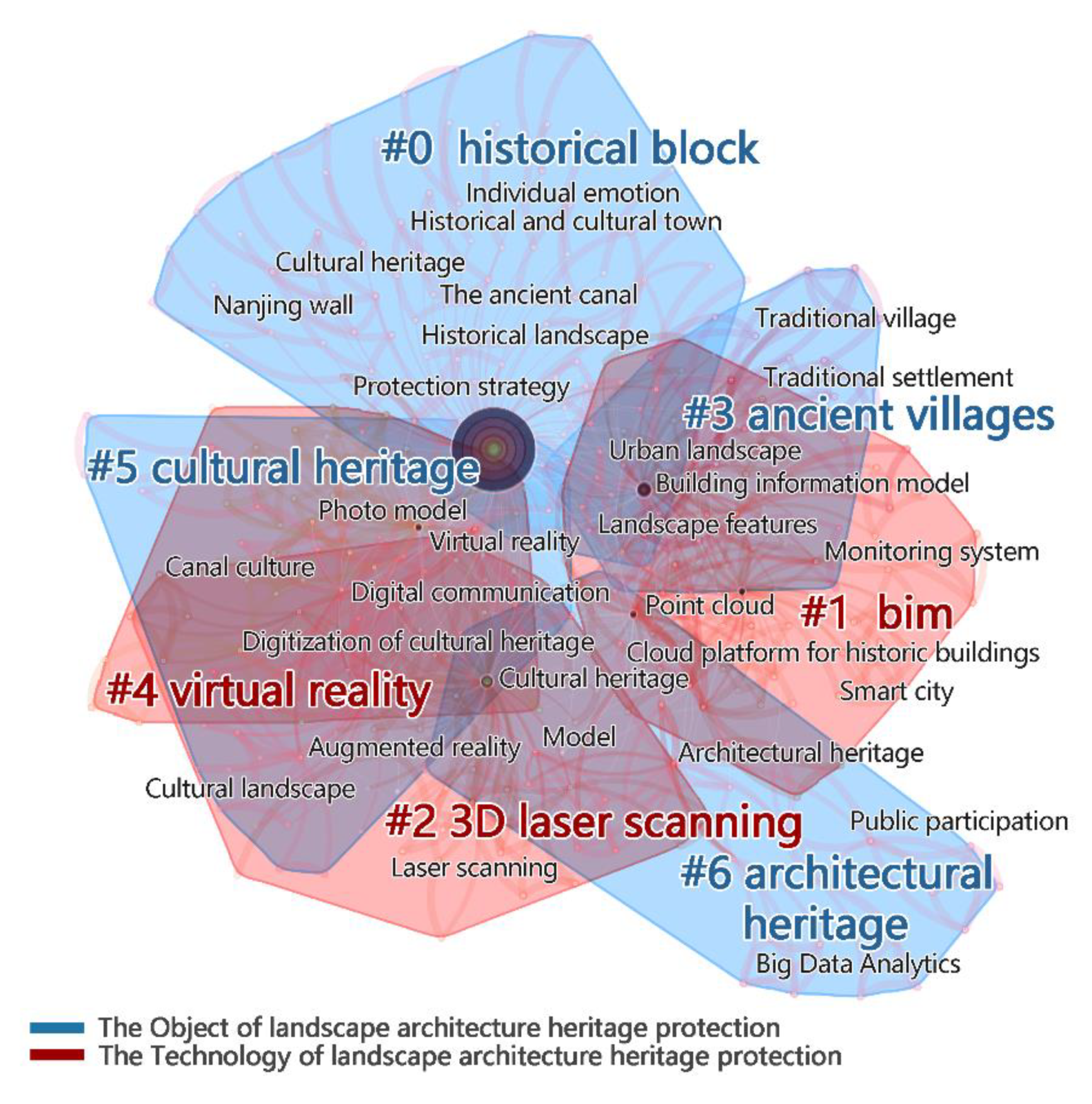
4.2. Research Hotspots and Trends of Digital Technology in Landscape Architecture Heritage Protection

Through clustering and time sequence analysis, it was found that the research hotspots of landscape architecture heritage protection over the past 10 years mainly focus on four types of heritage protection objects: historical blocks, ancient architecture protection, cultural heritage, and architectural heritage, and three types of digital technologies: 3D laser scanning, BIM, and virtual reality (Figure 5).
Through the analysis of the background of the application of digital technology in this paper, we can see that the development of digital technology has a great relationship with national policy and the specialized theory of the same period. With the development of time and the change in policy and theory, digital technology is also changing. Through literature analysis, we summarized the papers that involved related policies and theories of landscape architecture heritage protection published during the last 10 years, including all countries in the world. We analyzed the statistical emergence of digital technology and keywords in the field of landscape architecture heritage and classified them according to their policy background, professional theories, and application objectives (Figure 6).
It can be seen that a single technology was applied to a single object at the beginning. In other words, from 2012 to 2014, 3D laser scanning technology was mostly used for single objects, such as traditional buildings (ancient temples, cemeteries, ancestral halls, etc.). However, nowadays, it has gradually evolved into the comprehensive application and collaborative development of multiple digital technologies for multiple types of objects. For example, (the following keywords are highlighted in Figure 5), virtual reality technology (virtual display, virtual recovery, virtual building, etc.) is combined with images (photogrammetry, point cloud denoising, etc.) and information technology (parametric design, information integration, etc.) for complex research objects, such as a famous historical and cultural cities, urban historical landscapes, or villages from 2015. It is worth mentioning that in 2020, the “Co-building and sharing” of heritage information began to become a hotspot of digital technology in the field of landscape architecture heritage protection. Moreover, it started to integrate site culture and personal feelings into the category of heritage.
In other words, in the era of big data, in addition to confidential data such as planning results, the basic data, historical photos, and repair process of historical heritage can also be processed and opened to the public. At the same time, the public can also use information platforms to supplement and improve historical data, and the heritage culture and the public can realize two-way feedback [79]. Furthermore, the threshold of digital technology drops as professional equipment is gradually civilianized. UVA and 3D scanners are gradually becoming known and used by the public. With the help of professional equipment, crowdsourcing will be integrated into heritage protection [80,81] to realize data co-construction and, thus realize the construction of smart cities.
Consequently, the development process and evolution mechanism of digital technology for landscape architecture heritage protection over the past 10 years can be divided into three stages:
(a)
The stage of data precision. During the period of 2012–2014, owing to policy support, such as “Sponge City” and the “National Park” theory, etc., many ancient buildings, tombs, and some natural features in digital measurement appeared, which compared with the previous traditional measurement method, was more scientific and accurate. Furthermore, they combined GIS, GPS, and other information systems to create a database, which made the legacy data more accurate. In order to match the political intentions of “Updated and Sustainable Cultural Heritage Management”, Trier described a new method for the automatic detection of pit structures in airborne laser scanning data collected with at least five emitted pulses per square meter [82]; Gruetzner used an octocopter equipped with a high-resolution range finder camera to gather information on the topographical setting and morphometry of the rampart [44].
(b)
The stage of information systematization. From 2015 to 2017, under the guidance of “Double Urban Repairs” (“Ecological Restoration and City Betterment”), “Rural revitalization”, etc., heritage protection of traditional settlements and ancient villages became the focus of digital heritage research. The concept of “Resilience Landscape” enabled scholars to analyze the risks caused by geological disasters and extreme weather, allowing them to conduct virtual displays through data simulation to carry out preventive protection of heritage and form a relatively complete digital protection system of “collection, restoration and prevention”. Towards the development of The Copernicus Program in support of cultural heritage preservation and management, there is increasing exploitation of Interferometric Synthetic Aperture Radar (InSAR) methods to assess geohazards affecting cultural heritage [5]. As a result, Gupta conceptualized a framework for incorporating spatial and non-spatial knowledge of archaeological sites into a National Archaeological Database [83].
(c)
The stage of smart management. From 2018 to 2021, “Smart City” promoted the wisdom development of landscape architecture. Liang proposed that social media are one of the most important platforms to promote the public participation process of urban heritage conservation in the context of rapid urbanization [84]. Inclusion is a key value in the implementation of the “New Urban Agenda” and the achievement of sustainable development goals; Ginzarly proposed a methodology for the analysis of viewpoints location-view scenes-tags data for photos posted on Flickr to provide insights into all facets of the perceived landscape character that identifies people-centered heritage at the city level [58]. Digital protection is not just about the protection of heritage entities, it also pays attention to cultural protection, which through the way of virtual reality, artificial intelligence reproduces collective memory and personal emotion. As a result, the quality of information management and the traditional way of heritage protection were improved. The meaning of cultural heritage has been extended to the concept of “Cultural Landscape”. Demetrescu presented a new perspective for the documentation and representation of cultural landscape that includes not only the structures of the city but also the areas that have not been excavated yet, including the surrounding natural environment [60].
Therefore, while digital technology is showing a rapid development trend, the actual development problems that need to be solved and the focus of attention are also changing. Looking into the development of digital landscape architecture heritage protection in the future, from the perspective of macro heritage protection methods, the future of landscape architecture heritage protection no longer depends on government management and decision makers but is more inclined to combine the public’s co-building and sharing. From the perspective of micro-objects of protection, the protection of the physical environment of heritage itself in the past has evolved into the joint protection of heritage entities and cultural feelings.

5. Conclusions

According to more than 400 papers on digital technology in landscape architecture heritage protection published during the past 10 years, the main technical means can be divided into three aspects: collection and acquisition of heritage data, storage and management of heritage data, and dissemination and sharing of heritage information.
(a)
Collection and acquisition technology can be used to analyze the characteristics of the remaining elements of landscape architecture heritage, such as rockeries, architectural sketches, and buildings in precise digital models.
(b)
Designing the corresponding data system and platform through storage and management technology can repair and store the data in the database to manage the data according to different situations.
(c)
Dissemination and sharing technology can simulate the heritage environment, as well as disseminate and share heritage information to the public using new interaction and experience methods.
In addition, digital technology is mainly applied in the repair recovery and risk monitoring of landscape architecture heritage protection.
The digital development process and evolution mechanism of landscape architecture heritage protection are manifested in three stages: data precision, information systematization, and smart management. Looking into its future development, it can be seen that landscape architecture heritage protection will pay more attention to the use of digital technology to realize the sharing of information and the construction of a heritage protection platform; moreover, cultural emotionshould also be included in the category of heritage protection to realize the diversification of protection methods.

Notes

  • Historic Urban Landscape: “Historic Urban Landscape” is a suitable name for the natural and cultural and material and immaterial historical context and value in all cities. It is not solely suitable for “Historic town”, “Historic city”, and other special protection categories under the city.
  • Vincent. M.L scholars in the Heritage and Archaeology in the Digital Age: Acquisition, Curation, and Dissemination of Spatial Cultural To be specific, Heritage Data divide the digital technologies in the protection of cultural heritage into acquisition, curation, and dissemination, which are drawn from the ref. [24].
  • Photogrammetry: Cameras and other equipment obtain images of the object and describe the measured results in graphics, images, or models.
  • Structure from motion: A technique in which camera parameters are obtained by analyzing image sequences when 3D reconstruction is performed.
  • Digital twin: Using physical models and other data, complete mapping in virtual space reflects the corresponding physical equipment.
  • Sparse model: Removes redundant variables, retain explanatory variables related to response variables, simplify the model, and retain the most important information in the data set.
  • Sparse autoencoder: By calculating the error between the output and input of the autoencoder, the parameters of the autoencoder are constantly adjusted to train the model.
  • Compressed sensing: A technique for finding sparse solutions of underdetermined linear systems.
  • Synthetic aperture radar (SAR): A high-resolution imaging radar which can obtain high-resolution radar images similar to optical photography in meteorological conditions with very low visibility.
  • Multi-temporal: Reflects the characteristics of a group of remote sensing images in time series.

Author Contributions

R.Z. conceived and designed the whole structure of the paper and wrote the paper; C.Z. accomplished the data collation and wrote the paper. All authors have read and agreed to the published version of the manuscript.

Funding

This research was financially supported by the National Natural Science Foundation of China (No. 51908508) and the Natural Science Foundation of Zhejiang Province, China/Young Scholars Fund (No. LQ19E080024).

Data Availability Statement

Not applicable.

Conflicts of Interest

The authors declare no conflict of interest.

References

  1. Frodella, W.; Elashvili, M.; Spizzichino, D.; Gigli, G.; Nadaraia, A.; Kirkitadze, G.; Adikashvili, L.; Margottini, C.; Antidze, N.; Casagli, N. Applying close range non-destructive techniques for the detection of conservation problems in rock-carved cultural heritage sites. Remote Sens. 2021, 13, 1040. [Google Scholar] [CrossRef]
  2. Cai, L. Conceptual pedigree and process diagram of digital planning and design of landscape architecture. Landsc. Archit. 2013, 1, 48–57. [Google Scholar]
  3. Machete, R.; Silva, J.R.; Bento, R.; Falcao, A.P.; Goncalves, A.B.; de Carvalho, J.M.L.; Silva, D.V. Information transfer between two heritage BIMs for reconstruction support and facility management: The case study of the Chalet of the Countess of Edla, Sintra, Portugal. J. Cult. Herit. 2021, 49, 94–105. [Google Scholar] [CrossRef]
  4. Nicu, I.C. Is digital shoreline analysis system “fit” for gully erosion assessment? Catena 2021, 203, 105307. [Google Scholar] [CrossRef]
  5. Tapete, D.; Cigna, F. InSAR data for geohazard assessment in UNESCO World Heritage sites: State-of-the-art and perspectives in the Copernicus era. Int. J. Appl. Earth Obs. Geoinf. 2017, 63, 24–32. [Google Scholar] [CrossRef]
  6. Zhang, S.; Pang, B. Numerical simulation of landscape waterfall based on fluid dynamics theory. Water Supply Drain. 2014, 12, 120–123. [Google Scholar]
  7. Prieto, A.J. Fuzzy systems in the digital management of heritage timber buildings in South Chile. Build. Res. Inf. 2021, 49, 878–892. [Google Scholar] [CrossRef]
  8. Perko, D.; Hrvatin, M.; Ciglic, R. A Methodology for natural landscape typification of Slovenia. Acta Geogr. Slov. 2015, 55, 235–270. [Google Scholar] [CrossRef]
  9. Cheng, S.; Zhang, X.; Cheng, Y. Prospect of the application of digital landscape technology in the field of Chinese landscape architecture. Landsc. Archit. 2021, 28, 46–52. [Google Scholar]
  10. Academic Degrees Committee of the State Council. Demonstration Report on Adding Landscape Architecture as the First Level Discipline. Chin. Landsc. Archit. 2011, 27, 4–8. [Google Scholar]
  11. Han, F. World Heritage cultural landscape and its new international trends. Chin. Landsc. Archit. 2007, 11, 18–21. (In Chinese) [Google Scholar]
  12. Wu, D. On the protection of cultural landscape heritage and landscape culture. Chin. Landsc. Archit. 2011, 27, 1–3. [Google Scholar]
  13. Cao, X. Landscape architecture should play an important role in heritage protection. Landsc. Archit. 2012, 1, 154. [Google Scholar]
  14. Han, F. Cultural landscape in exploration. Chin. Landsc. Archit. 2012, 28, 5. [Google Scholar]
  15. Lin, G.; Xiao, L. Field and Evolution of Landscape architecture heritage protection. In Proceedings of the 2012 International Federation of Landscape Architects (IFLA) Asia-Pacific Regional Conference and 2012 Annual Conference of Chinese Society of Landscape Architecture, Shanghai, China, 22 October 2012; Volume I, pp. 90–94. [Google Scholar]
  16. Fadli, F.; AlSaeed, M. Digitizing vanishing architectural heritage; The design and development of Qatar historic buildings information modeling [Q-HBIM] platform. Sustainability 2019, 11, 2501. [Google Scholar] [CrossRef]
  17. Marra, A.; Gerbino, S.; Greco, A.; Fabbrocino, G. Combining Integrated Informative System and Historical Digital Twin for Maintenance and Preservation of Artistic Assets. Sensors 2021, 21, 5956. [Google Scholar] [CrossRef] [PubMed]
  18. Yang, C.; Han, F.; Liu, C. Research on spatial information recording and visualization of rural landscape heritage based on point cloud technology. Landsc. Archit. 2018, 25, 37–42. [Google Scholar]
  19. Yang, C.; Han, F. Digital heritage landscape: Research on Spatial Characteristics of large Rockery in Shanghai Yuyuan Garden based on 3D point cloud technology. Chin. Landsc. Archit. 2018, 34, 20–24. [Google Scholar]
  20. Zhang, B. Research on mountain management method of traditional Chinese garden promoted by three-dimensional digital technology. Anc. Landsc. Technol. 2010, 2, 36–38. [Google Scholar]
  21. Zhang, R.; Zhao, Y.; Kong, J.; Cheng, C.; Liu, X.; Zhang, C. Intelligent Recognitionand lts Sustainable Application forDecorative Openwork Windows of Traditional PrivateGardens in Suzhou China. Sustainability 2021, 13, 8439. [Google Scholar] [CrossRef]
  22. Deng, X.; Kim, I.T.; Shen, C. Research on Convolutional Neural Network-Based Virtual Reality Platform Framework for the Intangible Cultural Heritage Conservation of China Hainan Li Nationality: Boat-Shaped House as an Example. Math. Probl. Eng. 2021, 2021, 5538434. [Google Scholar] [CrossRef]
  23. Zhong, H.; Wang, L.; Zhang, H. The application of virtual reality technology in the digital preservation of cultural heritage. Comput. Sci. Inf. Syst. 2021, 18, 535–551. [Google Scholar] [CrossRef]
  24. Vincent, M.L.; Bendicho, V.M.L.M.; Ioannides, M.; Ioannides, M.; Levy, T.E. Heritage and Archaeology in the Digital Age: Acquisition, Curation, and Dissemination of Spatial Cultural Heritage Data; Springer International Publishing: Cham, Switzerland, 2017. [Google Scholar]
  25. Elassal, M. Geomorphological Heritage Attractions Proposed for Geotourism in Asir Mountains, Saudi Arabia. Geoheritage 2020, 12, 78. [Google Scholar] [CrossRef]
  26. Cucchiaro, S.; Fallu, D.J.; Zhang, H.; Walsh, K.; Van Oost, K.; Brown, A.G.; Tarolli, P. Multiplatform-SfM and TLS data fusion for monitoring agricultural terraces in complex topographic and landcover conditions. Remote Sens. 2020, 12, 1946. [Google Scholar] [CrossRef]
  27. Fu, H.; Fu, B.; Shi, P. An Improved Segmentation Method for Automatic Mapping of Cone Karst from Remote Sensing Data Based on DeepLab V3+ Model. Remote Sens. 2021, 13, 441. [Google Scholar] [CrossRef]
  28. Prus, B.; Wilkosz-Mamcarczyk, M.; Salata, T. Landmarks as Cultural Heritage Assets Affecting the Distribution of Settlements in Rural Areas—An Analysis Based on LIDAR DTM, Digital Photographs, and Historical Maps. Remote Sens. 2020, 12, 1778. [Google Scholar] [CrossRef]
  29. Cillis, G.; Statuto, D.; Picuno, P. Integrating remote-sensed and historical geodata to assess interactions between rural buildings and agroforestry land. J. Environ. Eng. Landsc. Manag. 2021, 29, 229–243. [Google Scholar] [CrossRef]
  30. Thuestad, A.E.; Risbøl, O.; Kleppe, J.I.; Barlindhaug, S.; Myrvoll, E.R. Archaeological Surveying of Subarctic and Arctic Landscapes: Comparing the Performance of Airborne Laser Scanning and Remote Sensing Image Data. Sustainability 2021, 13, 1917. [Google Scholar] [CrossRef]
  31. Cekada, M.T.; Radovan, D.; Lipus, B.; Mongus, D. Very Small Glaciers as Geoheritage: Combining a Spatio-Temporal Visualisation of Their Development and Related Effects of Climate Change. Geoheritage 2020, 12, 85. [Google Scholar] [CrossRef]
  32. Huilin, L. Research on 3D Digital Information of Suzhou Huanxiu Villa Garden; Nanjing Forestry University: Nanjing, China, 2018. [Google Scholar]
  33. Yu, M.Z.; Lin, X. Research on surveying and mapping methods of ponds and hills in classical gardens based on 3D laser scanning and close-range photogrammetry. Landsc. Archit. 2017, 2, 117–122. [Google Scholar]
  34. Moropoulou, A.; Zendri, E.; Ortiz, P.; Delegou, E.T.; Ntoutsi, I.; Balliana, E.; Becerra, J.; Ortiz, R. Scanning microscopy techniques as an assessment tool of materials and interventions for the protection of built cultural heritage. Scanning 2019, 2019, 5376214. [Google Scholar] [CrossRef] [PubMed]
  35. Oses, N.; Dornaika, F.; Moujahid, A. Image-based delineation and classification of built heritage masonry. Remote Sens. 2014, 6, 1863–1889. [Google Scholar] [CrossRef] [Green Version]
  36. Hou, X.; Cheng, B.; Yang, J. A quantitative study on the exterior wall texture of stone-built dwellings in traditional villages in China: A case study of the xisuo village in the Jiarong Tibetan area. J. Build. Eng. 2021, 42, 102357. [Google Scholar] [CrossRef]
  37. Liu, J. Component-driven pocedural modeling for ancient Chinese architecture of the Qing Dynasty. Int. J. Archit. Herit. 2018, 12, 280–307. [Google Scholar] [CrossRef]
  38. Zhu, X.; Chen, F.; Guo, H. Reconstruction of the Water Cultivation Paleoenvironment Dating Back to the Han and Tang Dynasties Surrounding the Yangguan Frontier Pass Using X-and L-Band SAR Data. Remote Sens. 2018, 10, 1536. [Google Scholar] [CrossRef]
  39. Bayarri, V.; Castillo, E.; Ripoll, S.; Sebastian, M.A. Improved application of hyperspectral analysis to rock art panels from El Castillo cave (Spain). Appl. Sci. 2021, 11, 1292. [Google Scholar] [CrossRef]
  40. Wang, N.; Wang, W.; Hu, W. Thangka Mural Line Drawing Based on Cross Dense Residual Architecture and Hard Pixel Balancing. IEEE Access 2021, 9, 48841–48850. [Google Scholar] [CrossRef]
  41. Ge, H.; Deng, S. Research on three-dimensional digital protection of Mausoleum stone carvings in Southern Dynasty. Urban Surv. 2014, 6, 14–16, 27. [Google Scholar]
  42. Yao, Y.; Wang, X.; Lu, L.; Liu, C.; Wu, Q.; Ren, H.; Yang, S.; Sun, R.; Luo, L.; Wu, K. Proportionated Distributions in Spatiotemporal Structure of the World Cultural Heritage Sites: Analysis and Countermeasures. Sustainability 2021, 13, 2148. [Google Scholar] [CrossRef]
  43. Martínez, S.; Ortiz, J.; Gil, M.L. Geometric documentation of historical pavements using automated digital photogrammetry and high-density reconstruction algorithms. J. Archaeol. Sci. 2015, 53, 1–11. [Google Scholar] [CrossRef]
  44. Grützner, C.; Bemmann, J.; Berking, J.; Frechen, M.; Klinger, R.; Klitzsch, N.; Linzen, S.; Mackens, S.; Oczipka, M.; Piezonka, H.; et al. Improving archaeological site analysis: A rampart in the middle Orkhon Valley investigated with combined geoscience techniques. J. Geophys. Eng. 2012, 9, S70–S80. [Google Scholar] [CrossRef]
  45. Karpinski, C. Natural heritage, documentation and research. Transinformação 2018, 24, 314–323. [Google Scholar]
  46. Wang, Y.; Wang, Y.; Fang, L.; Zhang, S.; Zhang, T.; Li, D.; Ge, D. Spatial-temporal characteristics and causes of changes to the county-level administrative toponyms cultural landscape in the eastern plains of China. PLoS ONE 2019, 14, e0217381. [Google Scholar] [CrossRef] [PubMed]
  47. Stott, D.; Kristiansen, S.M.; Sindbæk, S.M. Searching for Viking Age fortresses with automatic landscape classification and feature detection. Remote Sens. 2019, 11, 1881. [Google Scholar] [CrossRef] [Green Version]
  48. Gómez, J.C.; Magnin, L.A. Cartography of Geomorphological Units of the Bosques Petrificados de Jaramillo National Park (Santa Cruz, Argentina) for its Geo-Archaeological Implementation. Investig. Geográficas 2019, 98, 4. [Google Scholar] [CrossRef]
  49. Huang, C.; Zheng, F. Research on digital protection of temple murals in Tibetan, qiang and yi cultural industry corridor. J. Huaibei Vocat. Tech. Coll. 2021, 20, 61–66. [Google Scholar]
  50. Ozimek, A.; Ozimek, P.; Skabek, K.; Labedz, P. Digital Modelling and Accuracy Verification of a Complex Architectural Object Based on Photogrammetric Reconstruction. Buildings 2021, 11, 206. [Google Scholar] [CrossRef]
  51. Lalos, A.S.; Vlachos, E.; Arvanitis, G.; Moustakas, K.; Berberidis, K. Signal processing on static and dynamic 3d meshes: Sparse representations and applications. IEEE Access 2019, 7, 15779–15803. [Google Scholar] [CrossRef]
  52. Chen, X.; Zhou, M.; Zou, L.; Fan, L.; Hu, J.; Geng, G.; Zhang, H. A fast reconstruction method of the dense point-cloud model for cultural heritage artifacts based on compressed sensing and sparse auto-encoder. Opt. Quantum Electron. 2019, 51, 322. [Google Scholar] [CrossRef]
  53. Banuelos, J.K.; Miranda, A.R.; Valle-Melon, J.M.; Zornoza-Indart, A.; Castellano-Roman, M.; Angulo-Fornos, R.; Pinto-Puerto, F.; Ibanez, P.A.; Ferreira-Lopes, P. The Role of Information Management for the Sustainable Conservation of Cultural Heritage. Sustainability 2021, 13, 4325. [Google Scholar] [CrossRef]
  54. Abrate, M.; Bacciu, C.; Hast, A.; Marchetti, A.; Minutoli, S.; Tesconi, M. GeoMemories—A platform for visualizing historical, environmental and geospatial changes in the Italian landscape. ISPRS Int. J. Geo-Inf. 2013, 2, 432–455. [Google Scholar] [CrossRef]
  55. Jin, L. Application and prospect of the protection and digitalization of nanjing city wall cultural heritage. Nat. Cult. Herit. Res. 2019, 4, 39–43. [Google Scholar]
  56. He, S.; Zheng, H.; Tang, Z. Research on the construction of urban historical and cultural heritage management information system based on GIS. J. Guangdong Univ. Technol. 2018, 35, 38–44. [Google Scholar]
  57. Borodkin, L. 3D-Modeling and Virtual Reality Technologies in the Projects of Historical Urban Landscapes Reconstruction. ISTORIYA 2020, 11, 89. [Google Scholar] [CrossRef]
  58. Ginzarly, M.; Roders, A.P.; Teller, J. Mapping historic urban landscape values through social media. J. Cult. Herit. 2019, 36, 1–11. [Google Scholar] [CrossRef]
  59. Martinez-Grana, A.; Gonzalez-Delgado, J.A.; Ramos, C.; Gonzalo, J.C. Augmented Reality and Valorizing the Mesozoic Geological Heritage (Burgos, Spain). Sustainability 2018, 10, 4616. [Google Scholar] [CrossRef]
  60. Demetrescu, E.; d’Annibale, E.; Ferdani, D.; Fanini, B. Digital replica of cultural landscapes: An experimental reality-based workflow to create realistic, interactive open world experiences. J. Cult. Herit. 2020, 41, 125–141. [Google Scholar] [CrossRef]
  61. Jang, S.G. Holographic Technology Application: Features of Cultural Tourism and How to Localize It. Korean J. Local Gov. Adm. Stud. 2020, 34, 125–143. [Google Scholar]
  62. Buyuksalih, G.; Kan, T.; Ozkan, G.E.; Meric, M.; Isin, L.; Kersten, T.P. Preserving the knowledge of the past through virtual visits: From 3D laser scanning to virtual reality visualisation at the Istanbul Çatalca Incegiz caves. PFG–J. Photogramm. Remote Sens. Geoinf. Sci. 2020, 88, 133–146. [Google Scholar] [CrossRef]
  63. Clivaz, M.; Reynard, E. How to integrate invisible geomorphosites in an inventory: A case study in the Rhone River valley (Switzerland). Geoheritage 2018, 10, 527–541. [Google Scholar] [CrossRef]
  64. Yuan, N.; Guo, F.; Zhang, J. Research on the Digital Protection of Historic Buildings Based on the Whole Life Cycle: A Case Study of Duan Qirui’s Old Residence. Chongqing Archit. 2018, 17, 10–14. [Google Scholar]
  65. Lin, C. Integration of Tradition and Technology—Research on Digital Protection, Reconstruction and Reuse of Historic Buildings. New Archit. 2009, 3, 109–114. [Google Scholar]
  66. Zhang, J. Research on AR technology in digital protection of Dong buildings. Digit. World 2020, 6, 52. [Google Scholar]
  67. Guo, Y.; Wu, T.; Wang, X. Research on LIM Model Assisted “Planning”—An experiment on Digital Ground Model Construction of Qin Shihuang Mausoleum. Landsc. Archit. 2017, 11, 29–34. [Google Scholar]
  68. Carvajal-Ramírez, F.; Navarro-Ortega, A.D.; Agüera-Vega, F.; Martinez-Carricondo, P.; Mancini, F. Virtual reconstruction of damaged archaeological sites based on Unmanned Aerial Vehicle Photogrammetry and 3D modelling. Study case of a southeastern Iberia production area in the Bronze Age. Measurement 2019, 136, 225–236. [Google Scholar] [CrossRef]
  69. Liu, S. Application of 3D Laser Scanning Technology in the Protection of Ancient Petroglyph; Liaoning Technical University: Fuxin, China, 2011. [Google Scholar]
  70. Zhou, Y. Research on 3D Reconstruction and Restoration Technology of Terracotta Warriors and Horses; Northwest University: Xi’an, China, 2017. [Google Scholar]
  71. Gatter, R.; Cavalli, M.; Crema, S.; Martinez-Carricondo, P.; Mancini, F. Modelling the dynamics of a large rock landslide in the Dolomites (eastern Italian Alps) using multi-temporal DEMs. PeerJ 2018, 6, e5903. [Google Scholar] [CrossRef]
  72. Zouaoui, M.A.; Djebri, B.; Capsoni, A. From Point Cloud to HBIM to FEA, the Case of a Vernacular Architecture: Aggregate of the Kasbah of Algiers. J. Comput. Cult. Herit. (JOCCH) 2020, 14, 1–21. [Google Scholar] [CrossRef]
  73. Frodella, W.; Elashvili, M.; Spizzichino, D.; Gigli, G.; Adikashvili, L.; Vacheishvili, N.; Kirkitadze, G.; Nadaraia, A.; Margottini, C.; Casagli, N. Combining infrared thermography and uav digital photogrammetry for the protection and conservation of rupestrian cultural heritage sites in Georgia: A methodological application. Remote Sens. 2020, 12, 892. [Google Scholar] [CrossRef]
  74. Hemeda, S. Geo-environmental monitoring and 3D finite elements stability analysis for site investigation of underground monuments. Horemheb tomb (KV57), Luxor, Egypt. Herit. Sci. 2021, 9, 17. [Google Scholar] [CrossRef]
  75. Sobotkova, A.; Weissova, B. Soviet topographic maps and burial mounds of the Yambol province: Digital workflow for mortuary landscape verification. Archaeol. Prospect. 2020, 27, 253–262. [Google Scholar] [CrossRef]
  76. Anzidei, M.; Doumaz, F.; Vecchio, A.; Serpelloni, E.; Pizzimenti, L.; Civico, R.; Greco, M.; Martino, G.; Enei, F. Sea level rise scenario for 2100 AD in the Heritage Site of Pyrgi (Santa Severa). J. Mar. Sci. Eng. 2020, 8, 64. [Google Scholar] [CrossRef]
  77. Nicu, I.C.; Rubensdotter, L.; Stalsberg, K.; Nau, E. Coastal Erosion of Arctic Cultural Heritage in Danger: A Case Study from Svalbard, Norway. Water 2021, 13, 784. [Google Scholar] [CrossRef]
  78. Nicu, I.C.; Stalsberg, K.; Rubensdotter, L.; Martens, V.V.; Flyen, A.C. Coastal erosion affecting cultural heritage in Svalbard. A case study in Hiorthhamn (Adventfjorden)—An abandoned mining settlement. Sustainability 2020, 12, 2306. [Google Scholar] [CrossRef]
  79. Lin, Y. Public participation in heritage protection in the digital era: Based on the observation of fuyuan road in Fuzhou. Chin. Landsc. Archit. 2020, 36, 100–104. [Google Scholar]
  80. Hannewijk, B.; Vinella, F.L.; Khan, V.J.; Lykourentzou, I.; Papangelis, K.; Masthoff, J. Capturing the city’s heritage on-the-go: Design requirements for mobile crowdsourced cultural heritage. Sustainability 2020, 12, 2429. [Google Scholar] [CrossRef]
  81. Annad, O.; Bendaoud, A.; Goria, S. Web information monitoring and crowdsourcing for promoting and enhancing the Algerian geoheritage. Arab. J. Geosci. 2017, 10, 276. [Google Scholar] [CrossRef]
  82. Trier, O.D.; Pilo, L.H. Automatic detection of pit structures in airborne laser scanning data. Archaeol. Prospect. 2012, 19, 103–121. [Google Scholar] [CrossRef]
  83. Gupta, E.; Das, S.; Balan, K.S.C.; Kumar, V.; Rajani, M.B. The need for a National Archaeological database. Curr. Sci. 2017, 113, 1961–1973. [Google Scholar] [CrossRef]
  84. Liang, X.; Lu, Y.; Martin, J. A review of the role of social media for the cultural heritage sustainability. Sustainability 2021, 13, 1055. [Google Scholar] [CrossRef]
Figure 1. Annual changes of literature related to the digital landscape architecture heritage protection.
Land 11 01699 g001
Figure 2. Co-occurrence of keywords of digital landscape architecture heritage protection.
Land 11 01699 g002
Figure 3. Keyword clustering diagram of digital landscape architecture heritage protection.
Land 11 01699 g003
Figure 4. Classification map of digital technology in landscape architecture heritage protection.
Land 11 01699 g004
Figure 5. Landscape architecture heritage protection digital technology keywords cluster sequence diagram.
Land 11 01699 g005
Figure 6. Development trend and evolution mechanism of digital technology for landscape architecture heritage protection over the last 10 years.
Land 11 01699 g006
Table 1. The frequency of digital technology clustering information of landscape architecture heritage protection.
ClusteringKeywordsFrequency
Three-dimensional laser scanning3D model32
Digital protection technology25
Three-dimensional digitization23
Ancient buildings18
Point cloud17
UAV oblique photography17
The point cloud data12
Fine measurement6
Feature extraction3
Protection of surveying and mapping2
Pool and mountain outline2
BIMDigital protection system22
Informatization17
Building protection14
Cloud platform for historic buildings13
Recovery12
Digital information platform12
Parameterized component9
Information expression7
Point cloud denoising processing6
Accuracy of the check6
Simulation analysis4
Forward and reverse modeling2
Virtual realityDigitization of cultural heritage12
Three-dimensional technology8
VR images6
Digital Museum6
Virtual interactive scene design5
Augmented reality4
Construction roaming2
Immersive roaming1
Table 2. Classifications of collection and acquisition technology.
The Application ObjectThe Main ContentDigital Technology
TopographyLarge terrainTopographic lithologic maps, satellite images
Height changes terrainGround laser scanning, motion recovery structure data, digital elevation model
Complex landformOptical remote sensing, deep learning, digital elevation model
The polar landscapeLidar, remote sensing images, digital elevation models
RockeryRockery, rock sketchThree-dimensional laser scanning
ArchitectureTexture of building materialScanning electron microscopy, ultrasonic pulses, computational modeling
Architectural featuresPoint cloud components
Special formUAV oblique photography, three-dimensional laser scanning, artificial intelligence
Murals, stone carvingsRemote sensing measurement, photogrammetry, three-dimensional reconstruction
Other typesLarge area ruinsBig data
Historical roads, ancient city wallsDigital photogrammetry, high-resolution digital models
Book images, place namesDigital conversion
Unknown siteAirborne laser scanning, machine learning
Table 3. Classification of storage and management technologies.
Storage/ManagementThe Main ContentDigital Technology
Storage of heritage dataStorage and maintenanceBIM, big data, digital twins
Repair dataSparse model
Thin provisioning storage spaceDense point cloud reconstruction model
Management of heritage dataHeritage information assessmentHBIM, SDI, repository
Maintenance managementBIM, visualization platform
Preventive maintenanceArtificial intelligence
Table 4. Application of digital technology in landscape architecture heritage protection.
Application DirectionThe Main ContentDigital Technology
Repair recoveryTerrainDigital terrain model
ArchitectureThree-dimensional laser scanning, BIM, Internet of Things platform, augmented reality, virtual reality, artificial intelligence
Archaeological sitesUAV oblique photography, point cloud, orthophoto, digital surface model
The botanical garden environmentSynthetic aperture radar, terrain synthesis modeling, rendering algorithm
Landscape elementsDigital archives, three-dimensional point cloud technology
Risk monitoringAssess riskInterferometric synthetic aperture radar, multi-temporal high-resolution digital elevation model
Detect damage factorsBIM, infrared thermal imaging, UAV oblique photography
Statistical damage degreeRemote sensing, GIS, LiDAR
Set up analysis systemOrthophoto, UAV oblique photography, ground laser scanning
Publisher’s Note: MDPI stays neutral with regard to jurisdictional claims in published maps and institutional affiliations.

