Article

Reconstruction of Rural Settlement Patterns in China: The Role of Land Consolidation

1
College of Public Administration, Nanjing Agricultural University, Nanjing 210095, China
2
College of Public Administration and Policy, Shandong University of Finance and Economics, Jinan 250014, China
*
Author to whom correspondence should be addressed.
Land 2022, 11(10), 1823; https://doi.org/10.3390/land11101823
Submission received: 7 September 2022 / Revised: 9 October 2022 / Accepted: 13 October 2022 / Published: 18 October 2022
(This article belongs to the Special Issue Future Evolution of the Land Use Structure of Rural Settlements)

Abstract

:
Taking the supplement of the quantity and quality of cultivated land in rural settlements as the departure point, this paper discusses the spatial and temporal integration reconstruction method of rural settlements. The disorderly expansion of residential areas in Pinggu District, Beijing, China has led to the erosion of high-quality cultivated land in the region and the advantages of mountain resources have not been fully utilized in this area. Therefore, Pinggu District was selected as the research area. Using the spatial analysis function in GIS, this paper uses the comprehensive correction method of the per capita construction land standard and the neighborhood substitution method to analyze the quantitative potential of rural settlements to supplement cultivated land and the qualitative grade of cultivated land after arrangement. A combination of exclusion matrices are employed to identify the spatial and temporal arrangements of rural settlements. The research shows that the effective cultivated land area of rural settlements in Pinggu District is 514.24 ha, and the coefficient of increasing cultivated land is 9.25%. Rural residential areas in the district are divided into priority sorting area, key sorting area, moderate sorting area, and restricted sorting area; they account for 18.13%, 21.10%, 20.85%, and 39.93% of the total area, respectively. According to the regional characteristics and dominant factor of the different consolidation areas, corresponding consolidation goals, models, and engineering measures are proposed to enrich the theory and approach to village planning and to provide a reference for practitioners engaged in regional rural land consolidation. The innovation of this study is putting forward the consolidation objectives, models and engineering measures based on the regional characteristics and leading factors of different land consolidation areas. This study has reference significance for the formulation and implementation of regional rural settlements consolidation planning and the policy of increasing and decreasing urban and rural construction land.

1. Introduction

At present, China is engaged in an important period of building a new pattern of urban–rural economic and social integration [1,2,3]. Facing the strategic goals of industrialization [4], urbanization, and new rural construction, in view of the imbalance of urban and rural land use structures [5,6], a large number of rural land waste [7,8], and destruction of cultivated land resources [9] and so on, the country puts forward the rural settlements consolidation [10] and the link between increase and decrease of urban and rural construction land [11,12] strategies, which do not simply reduce expenditures but also free up resources for other projects.
Rural settlements are the carriers of farmers’ lives and production, and an important part of rural land utilization [13]. Rural settlements consolidation is an important aspect of comprehensive land improvement and a significant product in the process of economic development [14]. Related research on the spatial reconstruction of rural settlements at the county level in China has some limitations, such as a weak theoretical foundation and poor integration [15]. Meanwhile, rural settlements consolidation requires not only government support, but also the full consideration of farmers’ wishes, their economic conditions, their willingness to withdraw with compensation, and their willingness to move [16]. The government withdraws and merges large-scale villages in a manner of paid exit of residential land, neglecting needs specific to rural development in some villages [17]. Realizing the orderly reconstruction and functional improvement of rural settlements has become a strategic issue for the sustainable use of rural land [18]. At present, Chinese and international scholars have carried out relevant research on the integration potential of rural settlements [19], reconstruction type [20,21], evolution direction [22], resilience assessment and planning [23], collaborative optimization [24], transformation distribution [25,26], sustainable land use and transformation, and transformation and rural development path research [27,28,29]. It can alleviate the contradiction between supply and demand of cultivated land and achieve “smart growth” of rural development through the “smart contraction” of residential space [30]. According to the entropy value method [31], the two-dimensional modified index system [32], and the [33] “san sheng” classification measurement method, the settlement consolidation capacity is measured and optimized. Because the relocation policy for poverty alleviation benefits the spatial reconstruction and layout optimization of residential areas [34], some scholars have proposed an exchange mechanism for rural residential areas to move from small settlements to large settlements [35]; meanwhile, other scholars have proposed the concept of local urbanization [36]. However, in the process of consolidation, the rural social security system [37], cultivated land area [38], stakeholder relations, and human–land relations [39] are all significant factors affecting remediation. One of the principal objectives of spatial optimization and the reconstruction of rural settlements is to solve the problems of decentralization and the “hollowing out” of rural settlements [40]. Studies of the integration potential mainly focus on the method of finishing and supplementing the amount of cultivated land at the township or county scale. There are limited reports on the consolidation potential at the plot scale [41,42,43], the quality evaluation of cultivated land after consolidation [44], and the timing arrangement and spatial layout of arrangement [45,46].
Based on existing practices, the consolidation of rural settlements [10] not only guarantees land demand in the process of urbanization and industrialization, but also supplements the cultivated land and realizes the balance of cultivated land occupation and compensation [47], which offers a new way to solve the contradiction between human and land. However, from the perspective of the comprehensive balance and management requirements of the quality and quantity of cultivated land protection [48,49], there are still some problems and deviations: (1) there is a lack of a scientific method system for estimating the potential of rural settlements; (2) excessive pursuit of urbanization [50] leads to the occupation of large-scale, high-quality cultivated land resources [51], but the quality and production capacity of supplementary cultivated land are low; and (3) when studying diverse rural settlements, measures were not adapted to local conditions or for orderly coordination, and practitioners blindly engaged in residential construction and settlements mergers and acquisitions, resulting in the abandonment of cultivated land in mountainous areas and prominent ecological and environmental problems. These problems will inevitably hinder the coordinated development of urban and rural areas [52]. The keys to solving these problems are to comprehensively consider various factors that affect the consolidation of rural settlements and their degree of restriction [53], coordinate the amount of cultivated land for rural settlements and the quality of cultivated land after consolidation [44], rationally arrange the layout of land use [45,54], and form an organic whole with a reasonable hierarchical structure, scientific classification of types, and orderly coordination of time and space [46].
In view of this, this study examines the Pinggu District of Beijing and takes rural residential land plots as the evaluation unit. The paper discusses the index system and method for calculating the potential of rural residential land consolidation and supplementary cultivated land quantity to evaluate cultivated land quality grades after consolidation. Taking comprehensive productivity of post-cultivated land as the leading factor, we research the spatial reconstruction of rural settlements to enrich the theory and method [55,56] of land consolidation. This paper also provides a scientific basis for regional comprehensive land consolidation and urban–rural construction land increases and decreases associated with planning and other practical activities.

2. Research Framework

The arrangement of rural settlements is an important way to balance the occupation and compensation of cultivated land and to coordinate the development of urban and rural areas. This requires that the arrangement of rural settlement not only considers increasing the area of effective cultivated land, but also ensures that the quality of cultivated land [44]. does not decrease after arrangement. Therefore, from the perspective of land arrangement, this paper takes the quantity and quality of cultivated land as variables to explore the pattern of reconstruction of rural settlements (Figure 1).
First, we take the rural settlements in the study area as the research unit, and we analyze the scale of the current rural settlements and the theoretical potential of consolidation based on standard method of construction land method; by using the factor restriction method, we judge rural settlements that are suitable for becoming cultivated land and calculate supplementary effective cultivated land area from the aspects of natural suitability, ecological security, planning orientation, economic feasibility and social acceptability. Then, using the theory and method of agricultural land grading, we evaluate rural settlements quality level of cultivated land after consolidation. Finally, using the mutually exclusive matrix classification method, combining with the measurement of the quantity of supplementary cultivated land and the evaluation of the quality of cultivated land after consolidation, we study the temporal and spatial pattern configuration of rural settlements.

3. Research Methods

3.1. Rural Settlement Arrangement Supplies the Calculation of Cultivated Land Quantity

Using the per capita construction land standard method to calculate and evaluate the theoretical potential of land to supplement cultivated land, we combine factors including natural suitability, ecological security, economic feasibility, social acceptability, and planning orientation to establish a comprehensive correction index (Table 1) and determine whether rural settlements are suitable for consolidation into cultivated land and calculate the amount of effective cultivated land in rural settlements (real potential). The specific steps are from Section 3.1.1 to Section 3.1.2.
Table 1. Evaluation index system for integrated correction of rural residential consolidation potential.
Natural suitabilityIndicator layerIndicator quantification standardWeight
0305080100
Elevation/m>1000500–1000200–500100–2000–1000.19
Gradient/°>2515–2510–155–100–50.22
Soil thickness/cm<3030–6060–100100–150>1500.20
Soil texture––Gravel soilGravelClayLoam0.17
Soil organic matter content––<1.0%2.0–1.0%4.0–2.0%≥4.0%0.10
Soil configuration––Level 6, level 7Level 4, level 5Level 2, level 3Level 10.12
Ecological safetyType of ecological landIndicator layerIndicator quantification standard
0305080100
Water security landRiver and lake butter zoneRiver and lake and its surroundings 50 m50–100 m100–150 m>150 m
River and lake butter zone from water source protection zoneWater source protection core areaFirst-class water source protection areaSecond-class water source protection areaQuasi-grade water source protection areaOther areas
Type of water supply areaGroundwater recharge high suitability areaGroundwater recharge middle suitability areaGroundwater recharge low suitability areaOther areas
Biodiversity guaranteed landAncient treesMountain forest and its surroundings 60 m60–100 m100–200 mOther areas
Great egretLake wetlands and surrounding areas 500 m500–1000 m1000–2000 mOther areas
Recreational spaceNatural landscapeCore area of nature reserve humanities protection core areaKey protection areaStrict control areaGeneral control areaOther areas
Cultural attractionsHumanities protection core areaKey protection areaStrict control areaGeneral control areaOther areas
Disaster avoidance and protection landGeological disasterHigh-prone areaHigh-prone areaMiddle-prone areaLow-prone areaNon-prone zone
Water and soil erosionVery sensitive areaHighly sensitive areaMiddle sensitive areaLow sensitive areaInsensitive area
Economic feasibilityFactor layers and weightsIndicator
layers and weights
Factor layers and weightsIndicator layers and weightsFactor layers and weightsIndicator layers and weights
Investment ability
(0.53)
GDP per capita0.45Finishing cost
(0.21)
Proportion of buildings in rural settlements0.38Economic benefit (0.26)Minimum gold standard for industrial land0.39
Local finance earnings0.32Town influence distance0.32Level of grain yield0.61
Rural per capita net income0.23Road influence distance0.3
Social acceptabilityFactor layers and weightsIndicator layers and weightsFactor layers and weightsIndicator layers and weights
Government acceptability (0.55)Per capita cultivated land0.18Farmers acceptability (0.45)Proportion of rural secondary and tertiary labor force0.39
Reclaimable cultivated land reserve resource area0.21Rural education ratio of junior high school or above0.18
Cultivated land consolidation potential0.26Proportion of young and middle-aged population in rural areas0.14
The rate of decrease in the amount of cultivated land0.35Proportion of land used for public service facilities in rural areas0.29
Planning orientationType of planIndicator layerType of planIndicator layerType of planIndicator layer
New town planningNew town concentrated construction area and main townshipIndustry planningIndustrial Park, logistics parkTraffic regulationPlanning highway corridors
Note: The soil configuration classification corresponds to Table 2. See that table’s notes for details.
Table 2. Mutual exclusion matrix classification method for pattern reconstruction of rural settlements.
Quality Grade of Cultivated Land after ConsolidationFirst ClassSecond ClassThird ClassFourth ClassFifth Class
Sort out and supplement potential amount of cultivated landHigh potentialKey arrangement areaKey arrangement areaPriority arrangement areaPriority arrangement areaPriority arrangement area
Medium potentialModerate arrangement areaModerate arrangement areaKey arrangement areaPriority arrangement areaPriority arrangement area
Low potentialModerate arrangement areaModerate arrangement areaKey arrangement areaKey arrangement areaKey arrangement area
No potentialRestricted arrangement areaRestricted arrangement areaRestricted arrangement areaRestricted arrangement areaRestricted arrangement area

3.1.1. Establishment of Comprehensive Correction Index System

Based on the concepts in the above theoretical framework and related reference [57], the comprehensive revised index system of rural residential consolidation is constructed from two aspects of land consolidation and rural revitalization (Table 1). The correction of natural suitability follows the principles of representativeness, dominance, stability and accessibility of land quality, combines the research results of experts and considers the actual situation of Beijing. It selects soil texture, terrain slope, soil layer thickness, soil organic matter, soil body structure, and altitude as its evaluation factors of natural suitability of cultivated land. The ecological security correction mainly reflects the ecological tolerance and security degree of rural settlements and is measured by the “ecological land” one-vote veto. We think about two aspects of the impacts of rural settlements on the stability of surrounding ecosystems and the impacts of ecological problems, such as geological disasters, on the cultivated land after consolidation to identify different types of regional ecological land. We select indicators from regional water, biodiversity, recreation, and disaster safety. The social acceptability correction considers that rural settlement consolidation is a typical economic behavior. The raising of funds, the costs of demolition and the satisfaction of return and benefit all directly determine whether the potential of rural settlement consolidation can be realized. So, we select indicators from the aspects of investment ability, collation cost and economic benefit. Social acceptability correction considers that the government generally hopes to withdraw more land for construction though the consolidation of rural settlements and regards rural settlements as an important source of new construction land. However, due to the policy constraint of total cultivated land balance and cultivated land occupation and compensation balance, the government also has to consider the possibility of increasing cultivated land through the consolidation of rural settlements. In addition, rural settlements are the main place for farmers to live and produce, and the wishes and acceptability of farmers also affect the consolidation of rural settlements. Therefore, we select the indicators from the perspective of the government and the farmers. Planning orientation correction considers the influence of Planning Policy factors such as Space use Control on the release of rural settlement consolidation potential. Under the influence of urban planning, industrial planning, traffic planning, water conservancy planning and so on, some rural settlements with great potential for consolidation are urbanized, or planned to enter industrial parks, or occupied by traffic and water conservancy facilities, and are directly converted to other construction land. The potential of rural settlement consolidation to increase cultivated land should be reduced, we select indicators from urban planning, industrial planning, traffic planning and water conservancy planning.

3.1.2. Calculation Model of Realistic Potential of Rural Residential Area Consolidation

According to the theory of the “barrel effect”, the “minimum factor restriction law” [58] and indicators in Table 1, a general model for calculating the real potential of rural settlement consolidation is established (Equations (1)–(3)). At the same time, different correction models (Equations (4)–(7)) are constructed by considering the difference of restrictions of different correction factors on rural residential land consolidation The equations are as follows: The realistic potential of rural settlement consolidation is the product of the theoretical potential and theoretical potential comprehensive correction coefficient of rural settlement consolidation. The comprehensive correction coefficient of theoretical potential is multiplied by natural suitability correction coefficient, ecological security correction coefficient, economic feasibility correction coefficient, social acceptability correction coefficient and planning orientation correction coefficient. The theoretical potential of rural settlement consolidation is the product of the current area of rural settlements and the standard of per capita rural settlement. When the realistic potential value of rural settlement consolidation is more than 0, it shows that these plots are suitable for cultivated land. Finally, according to the natural quality of graded plot, these plots are divided into five grades. The higher the grade, the worse the quality.
P ( R ) = P ( T ) × F ( f ( i ) )
where P(R) represents the practical potential of rural settlement consolidation (i.e., rural settlement consolidation increases the effective cultivated land area); P(T) represents the theoretical potential of rural settlement consolidation; and F(f(i)) signifies the comprehensive correction coefficient of theoretical potential. P(T) is calculated using Equation (2), and F(f(i)) is calculated by Equation (3).
P ( T ) = M c s M p c s × Q t
where P(T) captures the theoretical potential of rural settlement consolidation; Mcs represents current status of rural settlements, Mpcs represents per capita standard ofrural settlements, with the appropriate per capita land use standard selected by subregion [59]. Qt represents the current rural population of natural villages. Since this study takes rural residential plots as the evaluation unit, the future rural population of other plots is difficult to predict, and the rural population of each natural village has changed little in recent years. One exception is the urbanization of the future rural population within the scope of the planned new town and the main town. Therefore, the current rural population of each natural village is adopted for the areas outside the scope of the planned new town and the main town.
F ( f ( i ) ) = f ( N s ) × f ( E s ) × f ( E f ) × f ( S a ) × f ( P g )
where F(f(i)) stands for the comprehensive correction coefficient of theoretical potential; F(Ns) represents the correction coefficient of natural suitability; F(Es) is the correction coefficient of ecological security; F(Ef) is the correction coefficient of economic feasibility; F(Sa) represents the correction coefficient of social acceptability; and F(Pg) is the planning guidance correction coefficient. When F(f(i)) is equal to zero (i.e., one or more single correction factors are zero), the rural residential land is not suitable for reclamation into cultivated land after consolidation due to one or more restrictive factors. When F(f(i)) is greater than zero, the land in rural residential areas is suitable for reclamation as cultivated land after consolidation—that is, the effective land for the quality evaluation of cultivated land after consolidation in rural residential areas. The specific calculation methods and steps of each correction coefficient are as follows:
 1.
Natural Suitability Correction Coefficient
According to the current situation and the data, the empirical method is used to determine the quantitative score and weight of the indicators. In view of the great difficulty in evaluating the natural suitability of rural residential plots, the natural suitability of cultivated land in the whole region is evaluated, and the natural suitability evaluation results are superimposed with the rural residential plots to obtain the natural suitability correction coefficient of rural residential areas.
According to Shelford’s restrictive law [60], the plots in the area where the quantitative score of the evaluation index is zero (i.e., the area where the elevation is greater than 1000 m, or the slope is higher than 25°, or the soil layer thickness is less than 30 cm) are directly determined as unsuitable for consolidation into cultivated land. The restrictive multi-factor evaluation model (Equation (4)) is available to calculate the natural suitability correction coefficient of each evaluation plot:
f ( N s ) = { 0 X i = 0 ; ( i = 1 n X i × w i ) / 100   X i 0 .
where f(Ns) represents the natural suitability correction coefficient for evaluating the consolidation potential of the plot; Wi is the weight of the index i; N is the number of evaluation indicators; and Xi is the quantitative score of index i.
 2.
Ecological Security Correction Coefficient
All ecological factors are considered to have the same importance in the construction of the ecological security pattern of rural settlement consolidation and are given the same weight. Similarly, in the process of natural suitability evaluation, when the evaluation plot is in an ecologically unsafe area, the quantitative score of the evaluation factor is zero, and the power index model is used to calculate the ecological security correction coefficient of each evaluation unit:
f ( E s ) = { 0 X j = 0 ; j = 1 m X j m / 100 X j 0 .
where f(Es) is the correction coefficient of ecological security for the evaluation of land consolidation potential; M is the number of evaluation factors; and Xj is the quantitative score of the index j.
 3.
Economic Feasibility Correction Coefficient
To obtain the relevant index data for each administrative region, the conceptual data for the administrative region are normalized by the range standardization (Equation (6)). The spatial block continuous data (urban and road impact distance) are quantified by the exponential attenuation model [60], and the economic feasibility correction coefficient of the rural settlement consolidation potential is calculated by the weighted summation model (Equation (7)):
X k = { ( I max I k ) / ( I max I min ) ( I k I min ) / ( I max I min )
where XK is the quantitative score of evaluation index K; IK is the actual score of evaluation index K; Imax is the maximum actual score of evaluation index K; and Imin is the minimum actual score of evaluation index K.
f ( E f ) = t = 1 p = t w t ·   ( k = 1 q = k X k × w k )
where f(Ef) represents the correction coefficient of economic feasibility of rural settlement consolidation potential; Xk is the quantitative score value of indicator K; wk is the weight of indicator K; wt is the weight of factor layer T; P represents the number of factor layers; and Q stands for the number of indicators of each factor layer.
 4.
Correction Coefficient of Social Acceptability
With reference to the method of economic feasibility evaluation (Equations (6) and (7)), we calculate the correction coefficient of the social acceptability of the rural settlement consolidation potential.
 5.
Planning-Oriented Correction Coefficient
The concept assignment method is adopted to determine the planning guidance correction coefficient of the rural settlement consolidation potential—that is, when the current rural settlement land falls within the space control range (urban planning area, industrial planning park, or planned traffic corridor passes through), f (Pg) equals zero; meanwhile, f (Pg) is equal to one for the rural settlement land outside the space control range.

3.2. Evaluation of Cultivated Land Quality after Rural Settlement Consolidation

Based on the above judgment, cultivated land quality after consolidation is evaluated for the land parcel (P (R) > 0) suitable for reclamation as cultivated land after rural settlement consolidation. Natural quality classification (CL)is a fundamental achievement but an important intermediate achievement of agricultural land classification. It is a correction of the natural quality of crop light and temperature production potential of the classified land as the evaluation unit, including all the information of the classification factors. It is an essential support for the analysis of cultivated land quality, the direction of land consolidation, and the division of consolidation type areas [61]. Therefore, according to the plot scale of this study, the cultivated land natural quality evaluation index system and calculation method (Equation (8)) in the agricultural land classification are selected to evaluate the cultivated land quality after rural settlement consolidation:
C L = k = 1 m w k · f k 100
where CL is the natural quality score of the graded plot; k is the number of evaluation factors; m is the number of evaluation indicators; wk is the weight of the index k; and fK is the score of the evaluation index affecting the quality of cultivated land. CL is a score between zero and one; the higher the score, the better the natural conditions of the rural settlements and the better the quality of cultivated land after consolidation. In the study, the plots participating in the cultivated land quality evaluation after rural residential settlement consolidation in the study area are divided into Grades I, II, III, IV, and V, which correspond to the following categories: less than 0.6, 0.6–0.7, 0.7–0.8, 0.8–0.9, and above 0.9. The higher the grade, the worse the quality.
It is worth noting that the natural suitability correction index in the calculation of the amount of supplementary cultivated land for rural settlement consolidation is similar to this index system. The former is taking the current attributes (before consolidation) of the terrain and soil-related factors as the index value, which can be obtained through the superposition of the current map. The latter is taking the plot attributes after rural settlements consolidation as the index value, which needs to be obtained by means of discrimination and substitution. According to the close relationship between the spatial distribution of rural settlements and cultivated land [57] and the similarity principle between the natural background characteristics of rural settlements and the site conditions of adjacent cultivated land, we analyze and compare the correspondence between land consolidation engineering and the evaluation index of natural quality of cultivated land, and divide evaluation indicators into difficult to transform and easy to transform. The former directly extract attribute information from the database and determine its index score compared with the index system. The latter uses the neighborhood substitution method to estimate the index score after consolidation. In other words, we judge the level that can be reached after the consolidation of rural settlements according to the natural conditions of the participation of graded plots in the neighborhood range of rural settlements. if there are irrigation conditions in the adjacent cultivated land, it is assumed that the cultivated land after the rural settlements consolidation can also be irrigated (see references [57] for the specific evaluation index system and evaluation steps).

3.3. Reconstruction of Rural Residential Area Pattern Based on the Quantity and Quality of Supplementary Cultivated Land

According to the above theories and methods, we carry out the frequency histogram statistics based on the amount of effective cultivated land supplemented by rural settlement consolidation after calculation. Regarding the frequency mutation point as the main basis of classification, it is divided into four grades: high potential, medium potential, low potential and no potential. Then, by using ARCGIS spatial analysis function, the realistic potential grade map of cultivated land quantity in rural residential area consolidation and the cultivated land quality grade map after consolidation are superimposed, and according to the leading idea of improving the comprehensive productivity of cultivated land after consolidation, the mutually exclusive matrix of temporal and spatial allocation of rural residential area consolidation is established (Table 2). Finally, according to the restrictive factors of rural settlement consolidation in different periods and spatial pattern, this paper puts forward the safeguard measures for the comprehensive renovation of rural settlements

4. Overview of Research Area and Data Processing

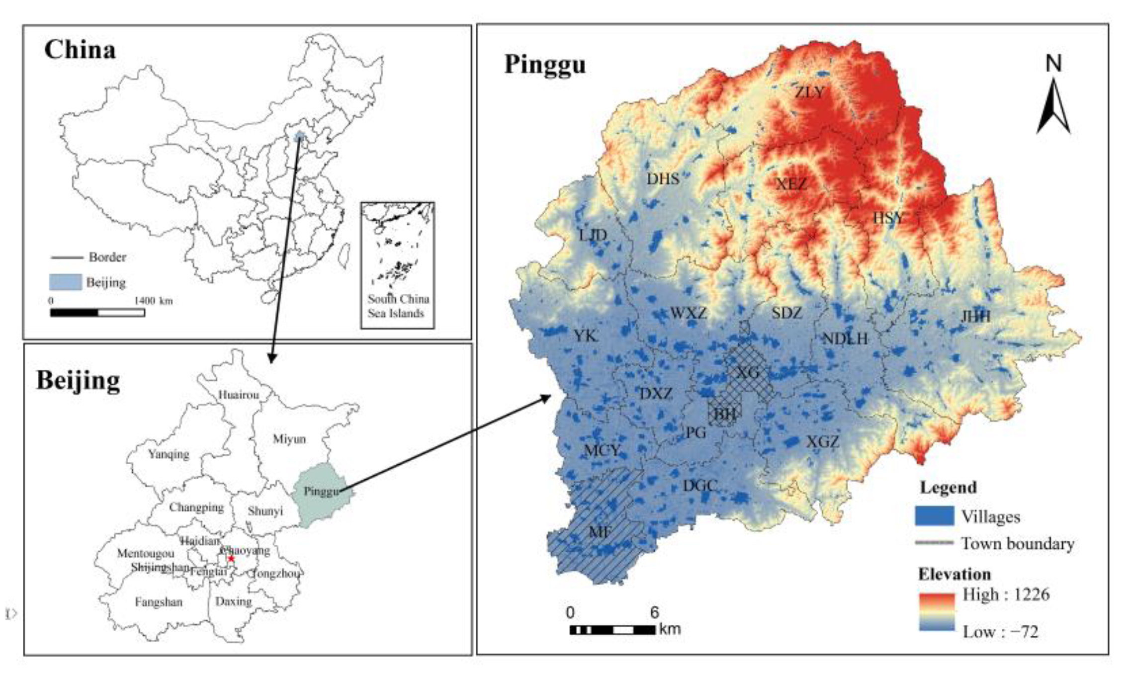
4.1. Overview of the Study Area

Pinggu District is located in the eastern area of Beijing, the distance to the central of Beijing is 70 km. It is one of the outer suburbs of Beijing. The total area of the jurisdiction is 950 km2, and there are 273 administrative villages. The terrain is high in the north and low in the south, with the highest elevation being 1224 m. According to the different geomorphic characteristics of the area, the whole region can be divided into plain, semi-mountainous, and mountainous areas, and the area of each account for about one-third of the total area of the jurisdiction. The mountainous area has beautiful scenery, forestry and tourism are relatively developed; the semi-mountainous area is the base of fruit production. The plains are the economic and cultural center of the region and the foremost producer of grain and vegetables. In the past 10 years, urban and rural construction land in the entire region has increased by nearly 2000 ha, of which about 80% is self-occupied cultivated land. Meanwhile, the per capita rural residential land area in the whole region is about 260 m2, which is far higher than the upper limit specified by national and Beijing’s standards. There is great potential for rural residential land consolidation.

4.2. Data Acquisition and Processing

Data for this study were available from several sources. The land use status map of Pinggu District in 2020 provided data on land extracted for urban construction, rural residential areas, and transportation facilities. The district’s soil map was utilized to obtain surface soil texture, soil configuration and other data. The Digital Elevation Model map (DEM), a solid ground model that represents ground elevation in the form of a set of ordered numerical arrays, can provide elevation and slope data. The results of agricultural land classification are obtained in Pinggu District in 2020, and the data on irrigation assurance rate, drainage conditions, and salinization degree of the classified plots. Pinggu District new town planning (2005–2020) resources provided data such as new town construction planning, industrial layout planning, regional road network planning, water source protection zoning, geological disaster distribution, and human and natural landscape distribution. The statistical yearbook of Pinggu District in 2020 supplied relevant economic and social data of various townships. Using the ArcGIS9.3 working platform, the relevant information is vectorized, the spatial projection coordinate system of each thematic map is unified, the rural residential plot and thematic map are registered and superimposed, and the basic attribute database of rural residential plots in the study area is formed.

5. Results

5.1. Quantity of Supplementary Cultivated Land for Rural Settlement

The theoretical potential of rural residential land consolidation in the whole region is 1978.53 ha, and the theoretical potential range of land consolidation in rural residential areas is 0~51.66 ha, which is a significant difference. After comprehensively considering natural suitability, ecological security, economic feasibility, social acceptability, planning guidance, and other restrictive factors of rural settlement consolidation and their amendments (Table 3, Figure 2 and Figure 3), the increased effective cultivated land area of rural settlement consolidation in the whole region is 514.24 ha, and the cultivated land coefficient increased by consolidation is 9.25%. The range of effective cultivated land area increased by land consolidation in rural settlements is 0~16.00 ha, with an average of 1.87 ha. The range of cultivated land coefficient increased after land consolidation by 0~44.23%, which is a significant difference; the comprehensive correction coefficient is 0.2599, and the potential loss affected by this is 1464.29 ha. From the high-potential level to the low-potential level, the actual potential, average value, total value, and increased cultivated land coefficient of a single plot all show a decreasing trend. On the one hand, this is significantly affected by the comprehensive correction coefficient, and on the other hand, it is also related to the theoretical potential of each level, which also leads to a decreasing trend of potential loss. The rural residential plot without potential involves the absolute restriction of natural suitability, ecological security, and planning guidance factors and their effects on the amount of supplementary cultivated land for rural residential settlement consolidation, resulting in the loss of 185.93 ha of theoretical potential. In terms of spatial distribution, the high-potential plots are mainly distributed in the central and southern flat areas. In addition to this flat terrain, the medium-potential plots are distributed in the low mountain and hilly areas in the east and west; low-potential blocks are mainly distributed in the northern mountainous area.

5.2. Quality of Cultivated Land after Rural Settlement Consolidation

Due to the absolutely restrictive influence of factors including natural suitability, ecological security, and planning guidance for amount of cultivated land supplemented by rural settlement consolidation, some rural residential plots should not be consolidated into cultivated land (the residential plots with no potential), with an area of 2193.65 ha and accounting for 39.96% of the rural residential area in the whole region. The corresponding land area of rural settlements with realistic potential is 3300.28 ha, which composes 60.04% of the total area of rural settlements in the region; this represents the effective plot for the evaluation of cultivated land quality after the rural settlements consolidation.
Based on the calculation of the scores of the various evaluation indexes after the consolidation of the evaluation plots, the natural quality score and corresponding quality grades of the rural residential plots are obtained (Figure 4 and Table 4). The results indicate that the natural quality score of cultivated land after consolidation of rural settlements in Pinggu District was between 0.3910 and 0.9745, with an average value of 0.7337. Among them, the first-class land area is 247.58 ha, accounting for 7.50% of the graded plot of the whole district, and the second-class land area is 384.47 ha, accounting for 11.65% of the graded plot of the district. These two rural settlements are concentrated in Mafang Town, Machangying Town, Daxingzhuang Town, and Hepinggu Town in the plain region. This is the area with the highest distribution of high-quality farmland in the entire district. Soil fertility is high, farmland infrastructure is good, and the cultivated land quality after consolidation is high. The area of third-class land is 1218.75 ha, accounting for 36.93% of the graded plot of the whole district. It is the main cultivated land after rural settlements consolidation, and is mainly distributed in Donggao Village Town, Yukou Town, Shandongzhuang Town, Wangxinzhuang Town, and Nandulehe Town. The terrain in this area is relatively flat, the irrigation and drainage conditions are slightly affected, the soil organic matter content and the terrain gradient have little impact, and the quality of the cultivated land after the consolidation is moderate. The fourth-class land area is 575.84 ha, accounting for 17.45% of the graded plot of the whole district, and the fifth-class land area is 873.64 ha (26.45%). These two rural settlements are mainly distributed in the low mountains and hilly areas of Xiagezhuang Town, Nandulehe Town, and Jinhaihu Town, and are also slightly distributed in Liujiadian Town, Dahuashan Town, and Luoying Town in the northern mountains. The terrain slope in this area is relatively large, and the agricultural land is mostly dry. The soil layer is poor, the soil texture is relatively coarse, and the quality of cultivated land after consolidation is low.

5.3. Reconstruction of Rural Settlement Pattern by Comprehensively Supplementing the Quantity and Quality of Cultivated Land

According to the short-term, medium-term, and long-term arrangements of the land renovation plan, we determined the spatial and temporal allocation of rural settlement consolidation in Pinggu District (Figure 5).

5.3.1. Priority Arrangement Area (Short Term)

The effective area of supplementary cultivated land and the quality of cultivated land after arranging the rural settlements in this area are both high, with a total area of 996.16 ha, concentrated in Machangying Town, Daxingzhuang Town, Mafang Town, and Donggao Village in the south-central region. The single plot area of rural settlements is large, with great theoretical potential and high correction coefficients. The area of supplementary effective cultivated land after arrangement is 207.42 ha, including 179.19 ha of high-potential land and 28.23 ha of medium-potential land. The cultivated land conditions after consolidation are also relatively good, with no restriction factors and high-quality grades, of which the fifth-class land accounts for 22.57%, the fourth-class land accounts for 34.89%, and the third-class land accounts for 42.54%. Therefore, in the process of planning and implementation, it can be used as a priority area in the near future.

5.3.2. Key Arrangement Area (Medium Term)

The consolidation of rural residential areas in this region is influenced by certain factors. The effective area of the supplementary arable land and the quality of the cultivated land after consolidation either high or low, with a total area of 1159.09 ha that is mainly distributed in Yukou Town, Wangxinzhuang Town, Shandongzhuang Town, and Jinhaihu Town. The total scale of rural residential areas is large, and the economic and social condition is slightly affected. The area of the supplementary arable land is 221.45 ha, including 143.93 ha of high-potential land. The middle-potential level is 63.74 ha, and the low-potential level is 13.77 ha. After the consolidation, most of the cultivated land is flat and the water source is basically guaranteed, mainly in the third class, accounting for 68.58%; this can be used as the key consolidation area in the middle of the planning region.

5.3.3. Moderate Arrangement Area (Long Term)

The consolidation of rural residential areas in this region is significantly restricted. The effective area of supplementary cultivated land and the quality of cultivated land after consolidation are low, with a total area of 1145.04 ha, mainly distributed in Xiagezhuang Town, Nandulehe Town, Liujiadian Town, the western parts of Jinhaihu Town, southern Wangxinzhuang Town, and southern Dahuashan Town. The rural residential areas are relatively small and scattered. Different regions are greatly affected by the correction factors, and the correction degree is huge, resulting in an area of 85.39 ha of arable land that can be supplemented. The cultivated land after consolidation is first-class land and second-class land, accounting for 64.28% and 35.72%, respectively. Although the potential is low, it has certain practical possibilities on the whole and can be used as the medium-long term regulation area in the planning and implementation.

5.3.4. Restricted Arrangement Area

This is the absolute restricted area for rural residential settlement arrangement by natural suitability, ecological security, and planning guidance. According to the dominance of various factors, the area can be divided into four categories: natural restriction, ecological restriction, planning restriction, and comprehensive restriction. The area of natural restriction is 378.22 ha, which is mainly distributed in the northern mountains. Restricted by the terrain gradient, the current rural settlements are small in scale and scattered in distribution, the agricultural population transfer is small, the soil is thin, and the soil nutrients are poor. The ecological restriction area is 384.15 ha, which is mainly distributed in the water source protection areas along the banks of the Weihe River and Ruhe River and around Haizi reservoir. The comprehensive restricted area is 333.45 ha, which is mainly a combination of natural and ecological restrictions, and it is distributed in geologically prone areas, sections where water and soil loss are prevalent, and core natural protection areas with significant ecological vulnerability. The planned restricted area is 1097.83 ha, which is mainly distributed in the new planned town of centralized construction area, Mafang Industrial and Logistics Park, the main towns and townships, and some main roads, and it is greatly affected by the planning guidance. In terms of the quantity and quality of the cultivated land to be consolidated and supplemented, this area should not be consolidated into cultivated land.

6. Discussion

6.1. The Temporal and Spatial Layout of Pinggu Distract

For the above temporal and spatial layout of Pinggu District:
First, the priority arrangement area relies on the guide and radiation of Pinggu new town, Mafang Industrial Park, and logistics park. The village’s collective economy is developed, and farmers are mainly engaged in the secondary and tertiary industries. The concept of villages is updated quickly, and expectations for building houses are concentrated. The rural residential areas are easy to arrange. In terms of the natural conditions, the quality of the soil nutrients in this area is medium to high, with a guaranteed water source, good irrigation and drainage conditions, and basically no restrictive factors. In addition, the farmers have high investments in arable land and strict management, so the land is suitable for cultivation. The rural settlements in this area should be mainly arranged in the mode of overall relocation and offsite transformation. After the consolidation, the cultivated land will develop large-scale and high-efficiency agriculture, maintain or continue to improve soil fertility, pay attention to the combination of use and nutrition, and constantly improve the quality of cultivated land.
Second, Jinhaihu Town and Yukou Town in the key arrangement area are the key small towns in Beijing, while Shandongzhuang Town and Wangxinzhuang Town are important parts of the new town. Relying on abundant industrial and tourism resources, the regional economy is developing rapidly, and the urbanization level is constantly improving. In the next 10 years, a large portion of the rural population will be transferred, and a large area of rural construction land will be saved, which is conducive to the promotion of rural residential settlement consolidation. In terms of natural conditions, there are a small number of mountain plots with sandy soil, low nutrients, poor irrigation facilities, and scattered plots. However, a little consolidation can be very beneficial. The consolidation of rural residential areas should focus on the retention and development of central villages and the internal transformation of grassroots villages. After the consolidation, the cultivated land should be fertilized, and irrigation and water conservancy projects should be constructed to continuously improve the efficiency of farming management.
Third, in addition to being affected by natural suitability conditions, each area in moderate consolidation area is slightly affected by other factors. Among them, Dahuashan Town and Liujiadian Town are far from the urban area or the town center, and the rural development lacks corresponding power support. The villagers are relatively closed-minded and are more resistant to the relocation of the villages. Many are restricted by economic and social factors, so it is difficult to promote the village renovation in the short term. Jinhaihu Town, on the other hand, has low social acceptability, and farmers’ high dependence on agricultural land is the main factor affecting the realization of consolidation potential. Southern Wangxinzhuang Town, Northern Xiagezhuang Town, andCentral Nandulehe Town are important underground water supply areas in Beijing. Ecological security is the main limiting factor for the consolidation of these rural settlements. In future rural settlement consolidation, the comprehensive construction of central villages and the merging of natural villages should be pursued. After consolidation, the cultivated land should be properly merged into the surrounding land; the terraced field construction should be strengthened and the supporting facilities for dry farming should be improved to increase the utilization rate of natural precipitation.
Finally, in the first three types of settlements in the restricted consolidation area, due to the harsh natural and ecological conditions, the local government and farmers tend to be accepting of the consolidation of rural settlements. However, the low-income potential of arable land, underdeveloped economy, weak investment capacity, and other factors hinder the consolidation of rural settlements. Therefore, this type of rural settlement should be properly sorted out from the perspective of natural suitability and ecological security. Ecological migration and village demolition and consolidation should be used as the main consolidation mode, and a strategy of one-time or phased relocation should be pursued. The local government should also increase regional financial investment. Some suitable plots should strengthen the supporting measures of terracing construction and dry farming, improve the utilization rate of natural precipitation, carry out the construction of shelter forests and water and soil conservation projects on the consolidated plots located in the core area of ecological land and the auxiliary area of ecological land, and properly develop the forest and fruit industry after reclamation. For the rural settlements with planning restrictions, the quality of cultivated land after consolidation is generally high. However, due to the guidance of planning policies and the requirements of urban development, such rural settlements will gradually be vacated for urban construction, and the main consolidation modes are to transform agriculture into housing and live in building in a centralized way. To a certain extent, this means that the land on which farmers live has been lost, and the source of livelihood of farmers has become the core issue. Therefore, effective compensation methods should be adopted in the process of such rural settlement consolidation, supplemented by social security measures or preferential policies to encourage farmers to start businesses or to provide employment opportunities. While changing the nature of land property rights, the employment structure of rural residents should be adapted to ensure incomes are protected.

6.2. Distinction and Connection of the Transformation of Regional Rural Settlements and the Transformation of Individual Villages

The transformation of regional rural settlements is mainly the mode of evacuating villages and living together [37], and the transformation of individual villages is mainly concentrated residence and to build rural areas into communities [19,36]. The purpose of both is to integrate idle land resources, reclaim rural settlements into cultivated land or for centralized construction, optimize the rural environment, alleviate the contradiction of land use, achieve the balance of cultivated land occupation and compensation and help the rural revitalization.
Compared with the transformation of individual villages, the transformation scope of regional rural settlements is larger and wider. It brings together scattered villages, this can generate scale effects and increase the area of restoration of cultivated and reclaimed land. Meanwhile, the transformation of regional rural settlements can make rational use of natural resources and geographical advantages according to local conditions, so as to obtain higher benefits.

6.3. Analysis and Insufficient

At present, the research on the reconstruction of rural settlement mainly focuses on the types of reconstruction, the characteristics of evolution, the evaluation and planning of consolidation potential, and the research on the potential of consolidation mainly focuses on the methods of sorting out and complementing the amount of cultivated land in villages and towns or counties. There are few reports on the potential of integration under the scale of plots, the quality evaluation of cultivated land after integration and the time arrangement and spatial layout of integration. Land consolidation can improve the ecological environment and promote economic development. This paper analyzes and rates the realistic potential of rural settlement consolidation from the scale of plots, classifies the plots suitable for conversion of cropland, and puts forward the corresponding consolidation model. However, the reconstruction of rural settlement pattern involves many factors, such as the wishes of farmers, social policy and so on. In the future research, we should also consider all aspects of factors.

7. Conclusions and Prospect

Ensuring the balance between the occupation and compensation of cultivated land and improving the comprehensive productivity of arable land are the important objectives of rural settlement consolidation, as well as the direction of China’s comprehensive rural land renovation. The quality and quantity of supplementary arable land should be coordinated. In view of the current situation—the quantitative evaluation of the comprehensive potential of rural settlement consolidation and research on the spatial-temporal integration allocation are insufficient—this paper examines the Pinggu District of Beijing and offers a calculation method and index system of the amount of land consolidation and supplementary arable land based on the comprehensive correction of natural suitability, ecological security, planning guidance, economic feasibility, and social acceptability. On this basis, the quality of cultivated land after consolidation in rural residential areas is quantitatively evaluated by applying the theory of agricultural land classification and the method of neighborhood substitution. Furthermore, the amount of supplementary cultivated land and the quality of cultivated land after consolidation are integrated, and the mutual exclusion matrix is used to construct the space-time integrated allocation method of rural settlement consolidation. According to the results, rural settlement land in Pinggu District is divided into priority consolidation, key consolidation, moderate consolidation, and limited consolidation areas. The corresponding consolidation mode and suggestions are proposed based on the discussion of the regional conditions, land use characteristics, and the constraints of each consolidation area.
The consolidation of rural settlements is a complex system engineering, and the influencing factors are also complex and diverse. In the areas with different levels of natural environment, social and economic development, the influence degree of each factor is also different. At present, there are still some difficulties in the research on the spatial reconstruction of rural settlements at the county level in China, such as weak theoretical basis, poor integration and so on. Therefore, in the process of rural settlement consolidation in the future, we should follow the principles of regional differences, functional dominance and problem constraints, and choose the choice and arrangement mode according to local conditions. The calculation method and index system of the amount of cultivated land to be consolidated and supplemented in plot scale put forward in this paper can be used for reference in the formulation and implementation of regional rural settlement consolidation planning and urban–rural construction land increase and decrease policy. The results of the study can provide scientific basis for the determination of cultivated land goal, the space-time arrangement of project area and the choice of key engineering measures and have positive significance for improving the level of comprehensive renovation planning of rural land, promoting the overall development of urban-rural areas and realizing the national food security strategy.

Author Contributions

Conceptualization, Y.Q. and J.C.; methodology, G.G.; software, Y.L. and G.G.; validation, X.D., Y.L. and L.Z.; formal analysis, X.D. and Y.L.; investigation, J.C.; resources, Y.Q.; data curation, L.Z. and G.G.; writing—original draft preparation, Y.L. and X.D.; writing—review and editing, L.Z. and Y.Q.; visualization, G.G. and L.Z.; supervision, J.C. and Y.Q.; funding acquisition, X.D. and J.C. All authors have read and agreed to the published version of the manuscript.

Funding

This research was funded by the funding of the National Natural Science; Foundation of China (Grant No. 42077434), and the Youth Innovation Technology Project of Higher School in Shandong Province (Grant No. 2019RWG016).

Institutional Review Board Statement

Not applicable.

Informed Consent Statement

Not applicable.

Data Availability Statement

Not applicable.

Conflicts of Interest

The authors declare no conflict of interest.

References

  1. Andrea, C.; Anjali, A.; Brown, D.L.; Luc, C.S.; Evans, D.K.; Annie, H.; Theresa, M.M.; Mark, P.; Sara, V.; Weiss, D.J. Economic and social development along the urban–rural continuum: New opportunities to inform policy. World Dev. 2022, 157, 105941. [Google Scholar]
  2. Riccardo, D.C.; Emanuele, S.; Michael, B. Urbanization and economic complexity. Sci. Rep. 2021, 11. [Google Scholar]
  3. Toure, S.I.; Stow, D.A.; Keith, C.; John, W. Patterns of land cover and land use change within the two major metropolitan areas of Ghana. Geocarto Int. 2020, 35, 209–223. [Google Scholar] [CrossRef]
  4. Melkamu, T.W.; Sisay, B.B. What lessons Ethiopia could draw from China’s township and village enterprises led rural industrialization? A thematic synthesis. Res. Glob. 2022, 5. [Google Scholar]
  5. Niu, X.; Liao, F.; Liu, Z.; Wu, G. Spatial–Temporal Characteristics and Driving Mechanisms of Land–Use Transition from the Perspective of Urban–Rural Transformation Development: A Case Study of the Yangtze River Delta. Land 2022, 11, 631. [Google Scholar] [CrossRef]
  6. Li, L.-H. Balancing Rural and Urban Development: Applying Coordinated Urban–Rural Development (CURD) Strategy to Achieve Sustainable Urbanisation in China. Sustainability 2017, 9, 1948. [Google Scholar] [CrossRef] [Green Version]
  7. Zhang, X.R.; Wang, J.; Song, W.; Wang, F.F.; Gao, X.; Liu, L.; Dong, K.; Yang, D.Z. Decoupling Analysis between Rural Population Change and Rural Construction Land Changes in China. Land 2022, 11, 231. [Google Scholar] [CrossRef]
  8. Maxim, G.; Morten, H. Development of agricultural land markets in countries in Eastern Europe and Central Asia. Land Use Policy 2022, 120, 106257. [Google Scholar]
  9. Miao, Y.; Liu, J.; Wang, R.Y. Occupation of Cultivated Land for Urban–Rural Expansion in China: Evidence from National Land Survey 1996–2006. Land 2021, 10, 1378. [Google Scholar] [CrossRef]
  10. Yang, F.; Chi, G.Q.; Wang, G.; Tang, S.R.; Li, Y.T.; Ju, C. Untangle the Complex Stakeholder Relationships in Rural Settlement Consolidation in China: A Social Network Approach. Land 2020, 9, 210. [Google Scholar] [CrossRef]
  11. Gorbenkova, E.; Shcherbina, E. Historical-Genetic Features in Rural Settlement System: A Case Study from Mogilev District (Mogilev Oblast, Belarus). Land 2020, 9, 165. [Google Scholar] [CrossRef]
  12. Yang, J.; Wu, Y.X.; Xia, C. Evaluation on the Suitability of Projects Linked to the Increase/Decrease in Urban and Rural Construction Land. Appl. Mech. Mater. 2013, 2301, 295–298. [Google Scholar] [CrossRef]
  13. Shang, R.; Qu, Y.B.; Jiang, H.L. Spatial and temporal characteristics and formation mechanism of rural settlement transformation from the perspective of human land relations. Resour. Sci. 2020, 42, 672–684. [Google Scholar]
  14. Liu, P.J. Research on Rural Settlement Consolidation in China. Hebei Agric. Sci. 2021, 25, 12–15. [Google Scholar]
  15. Lv, T.T.; Feng, Y.B. Research progress on spatial reconstruction of rural settlements at the county level. China Agric. Resour. Reg. 2021, 42, 79–86. [Google Scholar]
  16. Chen, Q.L.; Xu, L.; Wang, M.; He, P.R.; Wang, C.X. Village scale residential settlement consolidation potential classification—Empirical Research Based on the relationship between people and land and the revision of the subject’s will. Urban Rural. Plan. Des. 2021, 18, 64–68. [Google Scholar]
  17. Cai, F.M.; Lu, D.W.; Ye, Q.R. Discussion on the constraints for the realization of Rural Settlement Consolidation Potential. Rural. Econ. Sci. Technol. 2021, 32, 39–40. [Google Scholar]
  18. Kong, X.S.; Zhu, Z.Q.; Liu, D.F. Multi scale characteristics and spatial correlation analysis of rural settlement evolution in Jiangsu Province. J. Agric. Eng. 2020, 36, 247–256. [Google Scholar]
  19. Li, K.M.; Geng, H.Z.; Yue, L.Y.; Li, K.S.; Huang, L. Spatial Differentiation Characteristics and Driving Mechanism of Rural Settlements Transformation in the Metropolis: A Case Study of Pudong District, Shanghai. Front. Environ. Sci. 2021, 9. [Google Scholar] [CrossRef]
  20. Yue, Q.B.; He, J.H.; Liu, D.F. Identifying Restructuring Types of Rural Settlement Using Social Network Analysis: A Case Study of Ezhou City in Hubei Province of China. Chin. Geogr. Sci. 2021, 31, 1011–1028. [Google Scholar] [CrossRef]
  21. Kong, X.S.; Liu, D.F.; Tian, Y.S.; Liu, Y.L. Multi-objective spatial reconstruction of rural settlements considering intervillage social connections. J. Rural Stud. 2019, 84, 254–264. [Google Scholar] [CrossRef]
  22. Li, H.; Liu, M.D.; Hu, X.L. Spatial change characteristics and type division of rural human settlements from the perspective of smart contraction: Taking Changshu City, Jiangsu Province as an example. Geogr. Res. 2020, 39, 939–955. [Google Scholar]
  23. Zhou, J.Z.; Hou, Q.H. Resilience assessment and planning of suburban rural settlements based on complex network. Sustain. Prod. Consum. 2021, 28, 1645–1662. [Google Scholar] [CrossRef]
  24. He, Q.S.; Tan, S.K.; Zhou, M. Studies from Huazhong University of Science and Technology in the Area of Urban Systems Described (Collaborative Optimization of Rural Residential Land Consolidation and Urban Construction Land Expansion: A Case Study of Huangpi in Wuhan, China). Ecol. Environ. Conserv. 2019.
  25. Shahi, D.K.; Ahmad, E.; Anabstani, A.A.; Kumar, K.; Gupta, S.K.; Padmanaban, P.; Azizpour, F.; Shamsi, R.; Michael, C.; Dumitrescu, M.; et al. Distribution of rural settlements in the high himalayan region: A case study of har ki dun. Int. Multidiscip. Res. J. 2021, 11. [Google Scholar] [CrossRef]
  26. Li, W.; Zhu, X.C.; Yang, J.W.; Tian, Z.Y.; Bai, X.Y.; Sun, L.; Tang, X.Y. Consolidation Potential of Rural Residential Areas Based on the Village Classification. J. Agric. Chem. Environ. 2021, 10, 289–304. [Google Scholar] [CrossRef]
  27. Wei, C.; Lin, Q.; Yu, L.; Zhang, H.; Ye, S.; Zhang, D. Research on Sustainable Land Use Based on Production-Living-Ecological Function: A Case Study of Hubei Province, China. Sustainability 2021, 13, 996. [Google Scholar] [CrossRef]
  28. He, T.Q.; Qiao, W.F.; Jia, K.Y.; Chai, Y.B.; Sun, P.; Wang, Y.H.; Feng, T. Selecting Rural Development Paths Based on Village Multifunction: A Case of Jingjiang City, China. Complexity 2020, 5, 1–15. [Google Scholar] [CrossRef]
  29. Qu, Y.B.; Jiang, G.H.; Ma, W.Q.; Li, Z.T. How does the rural settlement transition contribute to shaping sustainable rural development? Evidence from Shandong, China. J. Rural. Stud. 2021, 82, 279–293. [Google Scholar]
  30. Li, L.; Li, X.J.; Hai, B.B.; Wang, X.F.; Xu, J.W. Evolution of rural settlement in an inland nonmetropolitan region of China at a time of rapid urbanisation: The case of Gongyi. J. Rural Stud. 2020, 79, 45–56. [Google Scholar] [CrossRef]
  31. Qu, Y.B.; Liu, M.; Zhu, W.Y. Multifunctional spatial pattern and coordination optimization model of rural residential areas. J. Nat. Resour. 2021, 36, 659–673. [Google Scholar]
  32. Liu, B.; Chen, C.; Tang, L.; Chen, Z.S.; Cao, C. Estimation Method of the Consolidation Potential of Rural Residential Land considering Farmers’ Willingness. Discret. Dyn. Nat. Soc. 2021, 2021, 1–13. [Google Scholar] [CrossRef]
  33. Hu, R.Z.; Wang, Y.P. Research on the Settlement Consolidation Potential of hollow villages based on the realizable angle: Taking Nanyang Village as an example. Hubei Agric. Sci. 2020, 59, 86–90. [Google Scholar]
  34. Lv, T.T. Research on Spatial Reconstruction of Rural Settlements in the County under the Background of Relocation for Poverty Alleviation—Taking Libo County, Guizhou Province as an Example; Guizhou University of Finance and Economics: Guiyang, China, 2020. [Google Scholar]
  35. Li, J.; Lo, K.; Zhang, P.Y.; Guo, M. Reclaiming small to fill large: A novel approach to rural residential land consolidation in China. Land Use Policy 2021, 109, 105706. [Google Scholar] [CrossRef]
  36. Rao, J. Comprehensive land consolidation as a development policy for rural vitalisation: Rural in Situ Urbanisation through semi socio-economic restructuring in Huai Town. J. Rural Stud. 2022, 93, 386–397. [Google Scholar] [CrossRef]
  37. Yuan, J. Review of the research on "removing villages and living together" from the perspective of urban and rural China. Soc. Sci. Forum 2020, 1, 79–95. [Google Scholar]
  38. Yang, H.P.; Yang, C.X.; Xin, G.X. Multifunctional evaluation and optimization strategies of rural residential areas in Southwest Hilly Areas—Taking Rongchang District of Chongqing as an example, China. Agric. Resour. Reg. 2020, 41, 153–161. [Google Scholar]
  39. Zhu, S.Y.; Kong, X.S.; Jiang, P. Identification of the human-land relationship involved in the urbanization of rural settlements in Wuhan city circle, China. J. Rural Stud. 2020, 77, 75–83. [Google Scholar] [CrossRef]
  40. Tu, S.S.; Long, H.L. Theoretical analysis of rural settlement spatial reconstruction. Geosciences 2020, 40, 509–517. [Google Scholar]
  41. Bizoza, A.R. Investigating the effectiveness of land use consolidation– a component of the crop intensification programme in Rwanda. J. Rural Stud. 2021, 87, 213–225. [Google Scholar] [CrossRef]
  42. Pašakarnis, G.; Maliene, V.; Dixon-Gough, R.; Malys, N. Decision support framework to rank and prioritise the potential land areas for comprehensive land consolidation. Land Use Policy 2021, 100, 104908. [Google Scholar] [CrossRef]
  43. Hau, L.S.; Liu, K.M.; Chzi, H.J.; Hu, C.L.; Huang, X.J.; Hshiung, T.G. A new hybrid modified MADM model for the potential evaluation of a comprehensive land consolidation project (LCP) toward achieving sustainable development. J. Environ. Plan. Manag. 2020, 63, 1585–1615. [Google Scholar]
  44. Zhou, J.; Cao, X.S. What is the policy improvement of China’s land consolidation? Evidence from completed land consolidation projects in Shaanxi Province. Land Use Policy 2020, 99, 104847. [Google Scholar]
  45. Song, W.; Li, H. Spatial pattern evolution of rural settlements from 1961 to 2030 in Tongzhou District, China. Land Use Policy 2020, 99, 105044. [Google Scholar] [CrossRef]
  46. Wu, Y.; Li, M.; Liu, L.; Zhang, Y.; Liu, L.; Wang, L. Spatial-temporal allocation of regional land consolidation project based on landscape pattern and system dynamics. Clust. Comput. 2017, 20, 3147–3160. [Google Scholar] [CrossRef]
  47. Chen, W.; Ye, X.; Li, J.; Fan, X.; Liu, Q.; Dong, W. Analyzing requisition–compensation balance of farmland policy in China through telecoupling: A case study in the middle reaches of Yangtze River Urban Agglomerations. Land Use Policy 2019, 83, 134–146. [Google Scholar] [CrossRef]
  48. Kuang, B.; Han, J.; Lu, X.; Zhang, X.; Fan, X. Quantitative evaluation of China’s cultivated land protection policies based on the PMC-Index model. Land Use Policy 2020, 99, 105062. [Google Scholar] [CrossRef]
  49. Zhou, Y.; Li, X.; Liu, Y. Cultivated land protection and rational use in China. Land Use Policy 2021, 106, 105454. [Google Scholar] [CrossRef]
  50. Marrero, M.; Puerto, M.; Rivero-Camacho, C.; Freire-Guerrero, A.; Solís-Guzmán, J. Assessing the economic impact and ecological footprint of construction and demolition waste during the urbanization of rural land. Resour. Conserv. Recycl. 2017, 111, 160–174. [Google Scholar] [CrossRef]
  51. Li, D.; Yang, Y.; Du, G.; Huang, S. Understanding the contradiction between rural poverty and rich cultivated land resources: A case study of Heilongjiang Province in Northeast China. Land Use Policy 2021, 108, 105673. [Google Scholar] [CrossRef]
  52. Zheng, Y.; Tan, J.; Huang, Y.; Wang, Z. The Governance Path of Urban–Rural Integration in Changing Urban–Rural Relationships in the Metropolitan Area: A Case Study of Wuhan, China. Land 2022, 11, 1334. [Google Scholar] [CrossRef]
  53. Shi, L.; Wang, Y. Evolution characteristics and driving factors of negative decoupled rural residential land and resident population in the Yellow River Basin. Land Use Policy 2021, 109, 105685. [Google Scholar] [CrossRef]
  54. Cho, S.-H.; David, H. Newman Spatial analysis of rural land development. For. Policy Econ. 2005, 7, 732–744. [Google Scholar] [CrossRef]
  55. Shcherbina, E.V.; Gorbenkova, E.V. Cluster Approach in Rural Settlement Development. IOP Conf. Ser. Mater. Sci. Eng. 2020, 753, 032086. [Google Scholar] [CrossRef]
  56. Shcherbina, E.; Gorbenkova, E. Factors Influencing the Rural Settlement Development. IFAC PapersOnLine 2019, 52, 231–235. [Google Scholar] [CrossRef]
  57. Qu, Y.B.; Zhang, F.R.; Guo, L.N. Evaluation and application of cultivated land quality after rural residential area consolidation. J. Agric. Eng. 2012, 28, 226–233. [Google Scholar]
  58. Song, W.; Chen, B.M.; Chen, X.W. Theory and demonstration of calculation model of rural residential land consolidation potential. J. Agric. Eng. 2008, 24, 1–5. [Google Scholar]
  59. Qu, Y.B.; Zhang, F.R.; Jiang, G.H. Study on zoning of rural residential land consolidation potential and “linkage”. Resour. Sci. 2011, 33, 2574–2582. [Google Scholar]
  60. Qu, Y.B.; Zhang, F.R. Suitability evaluation and zoning regulation of rural residential land based on ecological niche. J. Agric. Eng. 2010, 26, 290–296. [Google Scholar]
  61. Guo, L.N. Estimation and Application of Agricultural Land Grain Production Capacity Based on Classification; China Agricultural University: Beijing, China, 2009. [Google Scholar]
Figure 1. The research framework.
Land 11 01823 g001
Figure 2. Geographical location of Pinggu District.
Land 11 01823 g002
Figure 3. Distribution of realistic potential of rural residential land consolidation potential.
Land 11 01823 g003
Figure 4. Distribution of cultivated land grade after rural residential land consolidation.
Land 11 01823 g004
Figure 5. Spatial-temporal allocation of rural residential land consolidation in Pinggu.
Land 11 01823 g005
Table 3. Classification of realistic potential of rural residential land consolidation in Pinggu District.
Real Potential LevelActual Potential of A Single Plot/haAverage Plot Realistic Potential/haTotal Real Potential/haIncrease the Arable Land Coefficient/%Number of Farm SettlementsPotential Loss/haPotential Comprehensive Correction Factor
High potential(3.00, 16.00]5.38323.1015.5161622.710.34
Medium potential(1.00, 3.00]1.87149.308.3178443.670.25
Low potential(0, 1.00]0.4941.844.0184211.980.16
No potential000050185.930
Total[0, 16.00]1.87514.249.252731464.290.26
Table 4. Statistical data of cultivated land grade after rural residential land consolidation in Pinggu District.
Grading LevelScore IntervalMeanStandard DeviationArea/haRatio/%
First-class0.9024–0.97450.93790.0221247.587.50
Second-class0.8018–0.89560.86960.0304384.4711.65
Third-class0.7051–0.79870.72950.02521218.7536.93
Fourth-class0.6002–0.69820.63600.0234575.8417.45
Fifth-class0.3910–0.59910.49630.0216873.6426.47
Total0.3910–0.97450.73370.02433300.28100.00
Publisher’s Note: MDPI stays neutral with regard to jurisdictional claims in published maps and institutional affiliations.

