Article

Assessing Karst Landscape Degradation: A Case Study in Southern Italy

1
National Research Council, Institute of Research for the Geo-Hydrological Protection, Via G. Amendola, 122 I, 70125 Bari, Italy
2
Freelance Geologist, Ruvo di Puglia, 70037 Bari, Italy
3
Department of Earth and Environmental Sciences, University Aldo Moro, Via Orabona, 4, 70125 Bari, Italy
*
Author to whom correspondence should be addressed.
Land 2022, 11(10), 1842; https://doi.org/10.3390/land11101842
Submission received: 29 September 2022 / Revised: 14 October 2022 / Accepted: 16 October 2022 / Published: 19 October 2022
(This article belongs to the Section Land – Observation and Monitoring)

Abstract

:
Karst regions are peculiar due to their environmental and ecological features and hold a rich abundance of natural resources; nonetheless, they represent one of the most endangered areas in the world as a result of human activity. Further, urbanization and modernization of agricultural practices over the years determined an acceleration in the degradation of the karst environment. For a long period in the Apulia region, humans used to live in a sustainable equilibrium with the karst landscape; however, during the 1980s and 1990s, an intense conversion of land cover interested the area, determining a high disturbance of the karst landforms and landscape degradation. In this article, we propose an insight into a case study placed in the Alta Murgia area (Apulia, Italy) to analyze the evolution of the karst landscape over a period of 50 years (1954–2006) by means of geomorphological analysis and multi-temporal photo interpretation. Landcover mapping is carried out to catch landscape modification, and further, obliteration of the karst features through time is also detected. Changes are quantified, and related statistics are derived. Furthermore, to better characterize the area, the main morphometric parameters are also computed for doline. Finally, extensive fieldwork is carried out to verify the current state of the mapped elements and to check the most peculiar observed cases of land cover and karst landform transformations. Results show the intensive transformation experienced by the study site in the period 1973–2006, determined by the substantial land cover transition from pasture and permanent crops to cultivated areas. Further, the main karst features, such as doline and shallow valleys with flat bottoms, also locally known as lame, are partially or totally obliterated by agricultural practices.

1. Introduction

Karst landforms are among the most peculiar in terms of geological, geomorphological, hydrological, and ecological features [1,2]. Due to their characteristics, karst landscapes are unique, rich in natural resources such as high-quality water, and host remarkable species [3,4,5]. At the same time, the hydrological and hydrogeological characteristics of karst terrains [6,7], and the possibility, especially in lowland karst, to modify or cancel the original landforms [8,9] are at the origin of the fragility of karst environments, and of their high vulnerability to a variety of natural processes and anthropogenic actions as well [10,11,12,13].
Karst regions can be considered among the most fragile and vulnerable in the world, with man representing the most significant driving force towards possible degradation of the natural landscape [14,15,16]. In the last few decades in different parts of the world, the heavy human imprint has largely affected many karst environments, with the deriving effects documented in a number of studies on karst degradation.
Urbanization and the use of new machinery in agriculture may lead to a strong acceleration in the degradation of karst environments; in this regard, anthropogenic destruction or reshaping of karst landforms, such as dolines, has been observed worldwide [8,17,18,19]. People have used dolines for agricultural land purposes, transforming them to gain new surfaces suitable for cultivation, or in some cases, they have been completely filled [20,21,22,23,24,25,26]. In some countries, these severe transformations have led to intense erosion, even on low lands, with a strong tendency toward desertification [27,28].
In the Apulia Region (southern Italy), karst processes have extreme importance in shaping the landscape, given that this territory is widely characterized by outcrops of carbonate rocks [29,30]. Important changes related to human actions were observed in the period between 1970 and 2000 in the Murge, one of the main karst sub-regions in the central Apulia region, Italy [24]. Widespread agricultural conversion of uncultivated and wooded areas and over-exploitation of water led to considerable and irreversible effects in the Apulian karst, with consequent alteration of the delicate hydrological balance, both in terms of geological and hydraulic hazards and in relation to the management of water resources [31,32]. In this area, for centuries farmers practiced the removal of stones from the fields to make the land suitable for cultivation; this was typically carried out by hand, with the resulting material being used to build dry-stone walls and other storage houses typical of this part of Italy, but also found in other Mediterranean karst areas [9,33,34]. This activity was well integrated into the natural landscape since dry-stone walls [35] became a classical element of anthropogenic karst landforms in the area. In other words, man reached a high level of sustainability while living in karst areas in the past. Only marginal modifications were thus induced in the epikarst [36,37,38], which still had its fundamental role in recharging the karst aquifers, transferring to them the meteoric water. In addition, dry-stone walls also had other functions [39], such as preventing soil erosion since they were used to create small terraces, retarding the runoff contributing to reducing the possibility of flash floods, which frequently occur in karst, causing serious damage [40,41,42,43,44,45], and favoring the conservation of water in the areas closer to the dry-stone walls, thus creating typical ecosystems in their surroundings. This use of local rocks for building rural architecture to create a sustainable landscape well integrated into the natural one is typical of many cultures and civilizations that lived in karst settings [33,35,46] and at the origin of some of the most remarkable structures built for transport and the distribution of water [47,48,49,50,51].
During the 1970s, most of the Murge was used as pasture or uncultivated land, retaining the original vocation of this land, characterized by an outcrop of bare rock with very thin soil cover. At the end of this period and in the following decade, up to the beginning of the 1990s, a public program of financial support by the European Community promoted the conversion of land cover in order to increase the production of forage for animal breeding. As a consequence, stone removal began operation with heavy machinery, which worked at much greater depth than before when stone clearing was performed manually. These actions had immediate effects on the entire karst system of the area [21,43,52]. An intensive transformation was registered in that period, determining a significant land cover conversion from pasture land to arable land, mainly dedicated to wheat cultivation. To all of this, we must add the environmental problems related to quarrying [53], bringing the destruction of many surficial and subterranean karst landforms, with the possibility of contaminants introduction into groundwater systems. At the end of the 1980s, Alta Murgia became a National Park, with the goal of preserving its geological, geomorphological, and ecological features. To this aim, the Park recently proposed its candidature as a UNESCO Geopark [54,55].
In this context, we propose the analysis of an area of Alta Murgia aimed at describing landscape transformations through time in terms of land cover conversion and karst feature transformation and/or loss. With this goal, we aim to use the multi-temporal stereoscopic interpretation of aerial photographs. This is a fundamental tool for remote sensing analyses dedicated to evaluating the evolution of specific landforms through time and is especially useful for the determination of concave/convex landforms with expressed third-dimension. Furthermore, it is widely used to assess land use changes [56] or the positive and negative effects of human actions to mitigate risk from geological hazards. For instance, it has been extensively used in the field of slope movements, with many examples of multi-temporal analysis for different types of landslides [57,58], for the assessment of the validity of stabilization works [59,60], and for delineating the flood boundaries during extreme hydrological events, also in relation to the anthropogenic changes that occurred in the years over the studied areas [61,62]. Further, aerial photos have also been used to assess the susceptibility to debris flows and hyperconcentrated flows in alluvial fans interested in urban development [63,64].
In particular, we propose multi-temporal analysis, covering a time span from 1954 to 2006, based on digital photo interpretation, in order to understand which transformations occurred and which landforms have been modified or obliterated by the anthropogenic action. The use of remote sensing techniques (i.e., multi-temporal photo interpretation and digital stereographic mapping) allows for the identification of geomorphological features and landcover mapping, especially in cases where features are not easily detectable from field surveys or with traditional mapping. Furthermore, it is possible to carry out a comparison of images and outline the changes that determine landscape evolution/degradation through time. Eventually, geomorphological analysis that highlights the main karst features of the area and their morphometric parameters is also carried out.
In karst regions, the multi-temporal use of aerial photographs has been generally used to analyze sinkhole distribution and development [22,65,66] and in combination with DEM or Lidar data to identify and extract sinkhole-like features or to evaluate their connection with geological and tectonic structures [67,68,69,70].

2. Materials and Methods

2.1. Study Area

The study area covers approximately 50 km2, entirely within the limits of the “Alta Murgia National Park” (Figure 1) and is fully representative of the most typical geological and geomorphological asset of the local karst landscape.
Alta Murgia lies on a 3 km thick Cretaceous succession of the Apulian Foreland and reached its current antiform structure following the post-orogenic uplift that took place starting from the lower Pleistocene [71,72,73]. In this area, a Plio-Pleistocene succession (Calcarenite di Gravina Formation) is recognized, linked to a subsidence phase that led to the deposition of shallow-water calcarenites, passing upwards to the Argille Subappennine Formation, transgressively resting upon the fractured and karstified Cretaceous limestone bedrock [73,74]. This succession belongs to the Bradanic Trough cycle. Since the Middle Pleistocene, the Murgia area has been uplifted with consequent deposition of terraced marine deposits due to regional uplift and glacio-eustatic sea level changes [75,76,77].
Figure 1. Location of the study area (red square) and simplified geological setting of the Murge (modified after [73]).
Land 11 01842 g001
Morphologically, Alta Murgia is a plateau ranging in altitude between 450 and 700 m a.s.l.; its geological structure corresponds to an asymmetric NW–SE trending horst and graben system, bordered by normal and transtensive faults inherited from late Cretaceous tectonics [29,73,78,79].
Karst processes in the area are favored by lithological, geological, and structural characteristics and by tectonic history. According to ref. [29], Murgia karst landforms are characterized by peculiar features compared to other karst areas in Southern Italy (see Figure 2). These are essentially the large diameters and the limited depth of most of the landforms, together with the polygonal geometries and the coalescence of adjacent dolines, which can be locally described as a honeycomb complex. This peculiar karst landscape has been interpreted as “low relief cockpit karst”, whose origin is attributable to the late Tertiary period, with quite different climate conditions with respect to the present [29,30]. Collapsed sinkholes, according to refs. [80,81,82], locally take the name of “puli” [83] and represent the most prominent landform in terms of size and depth. They are associated with erosion and the collapses of karst caves, accelerated by the intrusion of brackish waters for those located closer to the ancient coastlines during the transgressive phases of the lower Pleistocene [74,84,85,86].
Shallow valleys with flat bottoms related to the presence of water at the ground surface, locally called “lame” [83], are the main element of the local surface hydrographic pattern. Due to their low relief, they are particularly prone to be easily reshaped by agricultural practices or by stone clearing, which usually leads to strong changes in the original karst landforms [30].

2.2. Data and Methods

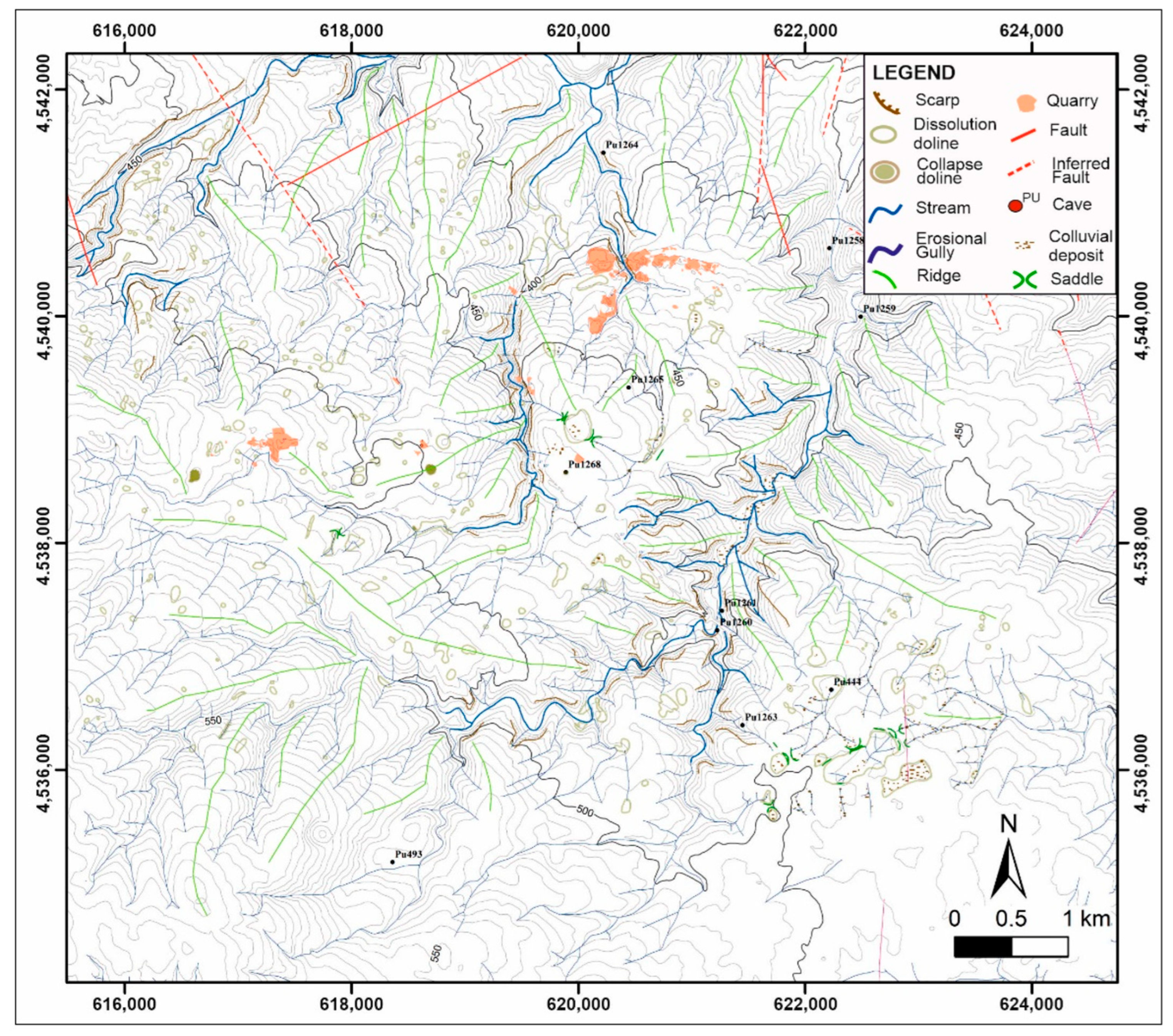
Karst features were mapped through aerial photo interpretation by exploiting the stereographic digital viewer of the ERDAS Imagine software (ERDAS Imagine software, 2016, version 16.0). Stereo-pairs were elaborated using aerial photos acquired from the Italian Military Geographical Institute (IGMI). The mapping procedure was carried out in a GIS environment using ESRI ArcMap (version 10.5.1) and Qgis (version 3.16) software, and the mapped elements were then classified and analyzed, following a procedure already successfully tested for other sectors in the Apulian karst [70,87]. The geomorphological karst map was produced by recognition of the main geomorphological elements in the karst environment, such as morphological scarps, dissolution and collapse doline, streams, erosional gullies, ridges, cave entrances, colluvial deposits, and morphological saddles. Structural elements such as faults and inferred faults were also reported, as extracted from aerial photos and field surveys. Further, mining and quarry areas were highlighted due to the importance of this activity in the Murge, as in the rest of Apulia [53,88].
Multi-temporal land cover mapping was operated by the analysis of aerial photos from different time periods. A time interval of 52 years (1954–2006) was covered, divided into two different spans: 1954–1973 and 1973–2006, and three vectorial maps were obtained. Panchromatic aerial photos taken in 1954 and 1973 were acquired from IGMI and scanned with a resolution of 800 dpi. For the year 2006, we used the orthophotos available from the Apulia Region archive (Available online: http://www.sit.puglia.it/ (accessed on 17 May 2022)). For 1954, we analyzed 4 aerial photos shot from an altitude of 6000 m with a scale of 1:35,000, whilst for 1973 we analyzed 4 aerial photos shot from an altitude of 4500 m with a scale of 1:28,000. For 2006 we used 9 digital color orthophotos with a 0.5 m resolution. Orthorectification and co-registration were operated to reduce uncertainties [66,89,90]. Orthorectification was realized using 12 Ground Control Points (GCPs), 20 Tie points, and 3 GCPs for each photograph, based on the 5 m DTM.
After aerial photo preparation, the land cover was mapped in a GIS environment using a scale of 1:5000, with a Minimum Mappin Unit (MMU) of 24 × 24 m [91]. Afterward, changes detection and quantification were operated by computing parametric indexes.
Seven land cover classes were distinguished: settlements, cultivated area, forest land, pasture, shrubland, wetland, and bare land.
Multi-temporal land cover changes were identified by means of the transition matrices 1954–1973 and 1973–2006. Those allowed us to detect the dynamical variation (or persistence) of each class by displaying the aerial extension in a table that shows the time T0 on the x-axis and T1 on the y-axis [56,92,93]. Statistics were elaborated with the support of the Qgis software plugin MOLUSCE.
Extensive fieldwork was eventually carried out to validate the observed changes for both karst elements and land cover classes.
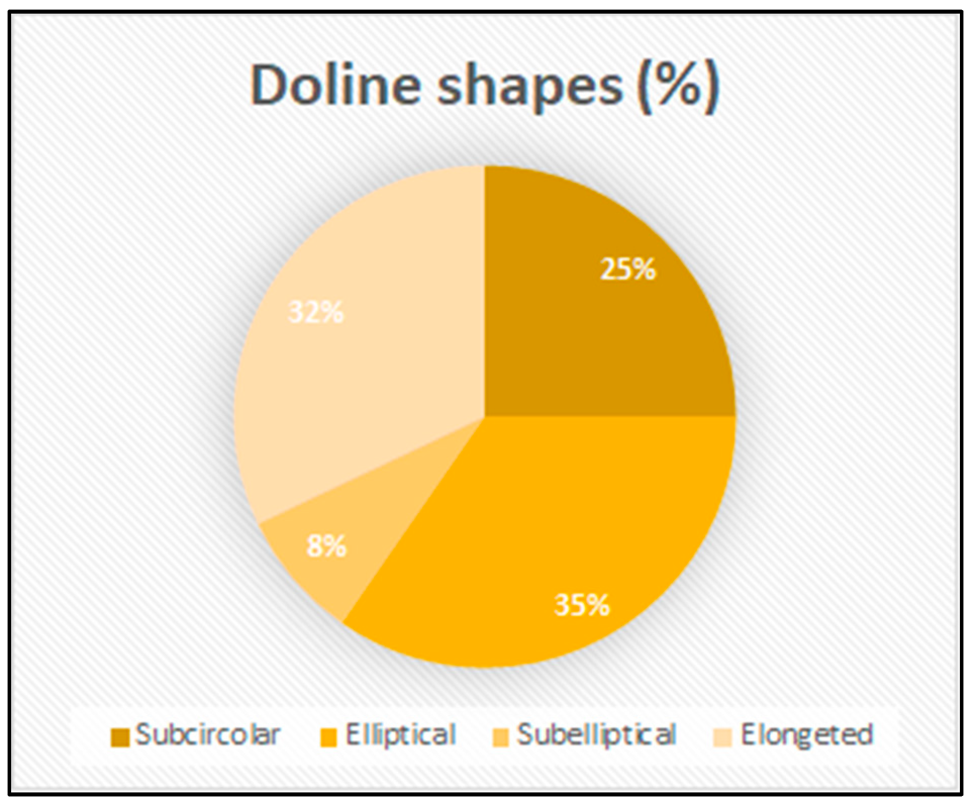
Furthermore, the main morphometric parameters for doline, such as area, perimeter, Circularity Index (CI), and Elongation Ratio (ER) [94,95], were calculated from a 1954 aerial photo. In detail, the area and perimeter were obtained using the GIS geometry tool, while the CI was calculated using the formula proposed in ref. [96], which attributed a value equal to 1 to perfect circular shapes, while elongated shapes were assigned lower values, following an approach already implemented in previous studies on karst settings [70,97,98,99]. ER was calculated as the ratio between the longest and the shortest axes. The latter were identified by drawing a rectangle, namely the minimum bounding box [100,101,102], bordering the feature. ER defines the feature shapes distinguished on the basis of ER values in circular (ER < 1.05), sub-circular (1.05 < ER ≤ 1.21), elliptical (1.21 < ER ≤ 1.65), sub-elliptical (1.65 < ER ≤ 1.8), and elongated (ER > 1.8) shapes [70].

3. Results and Discussion

3.1. Morphological Characteristics of the Karst Landforms

The aerial photo interpretation carried out by means of digital stereoscopy led to the identification of the most relevant geomorphological elements in the area. The Murgia landscape is characterized by a significant number of different types of dolines/sinkholes, belonging mostly to the categories of collapse and solution types [103,104]. Collapse dolines are the sharpest in terms of effects on the landscape: their vertical walls and high depth make them the prominent karst landforms in Murgia, with the Altamura Pulo and the Gravina Pulicchio as the most significant (reaching a depth of 90 and 110 m, and diameter of 700 and 530 m) [84,86,105,106]. Other karst landforms, such as poljes [107,108,109], are less represented in this sector of Murgia; nevertheless, one of the most remarkable poljes of Apulia is located in the Low Murgia area [87,110] and hosts the deepest cave in the region, reaching the water table at −264 m from the ground surface, and a total explored depth of −324 m [111,112].
The geomorphological map shown in Figure 3 reports the study area in the presence of a relevant number of dolines and endorheic basins, depicting a peculiar landscape which has been described by several authors [29,30] as produced in climatic conditions quite different from the present ones, similarly to the cockpit karst landscape, today typical of tropical regions [113,114,115]. The area is incised by numerous short temporary streams, which represent the relict of old water drainage lines and are locally called lame. Often marked by the presence of terra rossa deposits [116] and with a slight connection with the adjoining flanks, they eventually find their base level at the bottom of a depression or doline. Colluvial deposits, identified at the bottom of topographic depressions such as endorheic basins and dolines, are at the origin of the formation of temporary lakes due to stagnancy of water after heavy rainstorms, as frequently recorded in many areas of the Apulian karst [117]. In the Murgia karst, several caves are present (Table 1), with variable depth and development [118] (location of caves from the regional inventory, available online: http://www.catasto.fspuglia.it/ (accessed on 17 May 2022)).
Overall, the above are the main testimonies of past karst processes, but some of them have also been partly lost due to anthropogenic changes. Grave Ferratella (PU 444 in the regional inventory of caves) was once the deepest in Apulia, reaching a total depth of 320 m from the ground surface; explorations were still ongoing when access was halted by farmers by dropping rocks and soil within the main shaft after clearing the stone of the field [119].
Several limestone quarries are also present in the investigated sector; this is due to the fact that much of the local rock has long since been extracted and used as ornamental stone and building rock [120,121,122].
Morphometric parameters (Table 2) indicate the main characteristics of dolines; they can also be used to understand the main mechanisms at the origin of their formation and their related hydrologic role as well [123,124]. The average area is 5213 m, while the perimeter ranges from 1783 m to 35 m. Proximity values measure the distance (in m) between a doline and the neighboring ones. The measured average distance is 113.81 m, with a minimum distance of 6 m.
The ER indicates a maximum value of 8.53 (elongated shape) and a minimum of 1.02 (circular shape), while the mean is 1.72 (sub-elliptical shape), and the median is 1.47 (elliptical shape).
The graph in Figure 4 reports the percentage of the shapes calculated with the ER formula. It is possible to observe that sub-elliptical shapes are less represented, and the circular form is not represented at all, while among subcircular, elliptical, and elongated shapes, no class is largely predominant.

3.2. Landcover and Karst Features Transformations

Multi-temporal analysis from aerial photo interpretation highlighted that the main changes in terms of land cover, as well as the transformation in karst landforms due to anthropogenic actions, occurred in two time intervals: 1954–1973 and 1973–2006. In general, it was observed that the most significant transformations were registered in the last time interval, 1973 to 2006, and the period 1954–1973 can be overlooked (Table S1 available as Supplementary Material to this article).
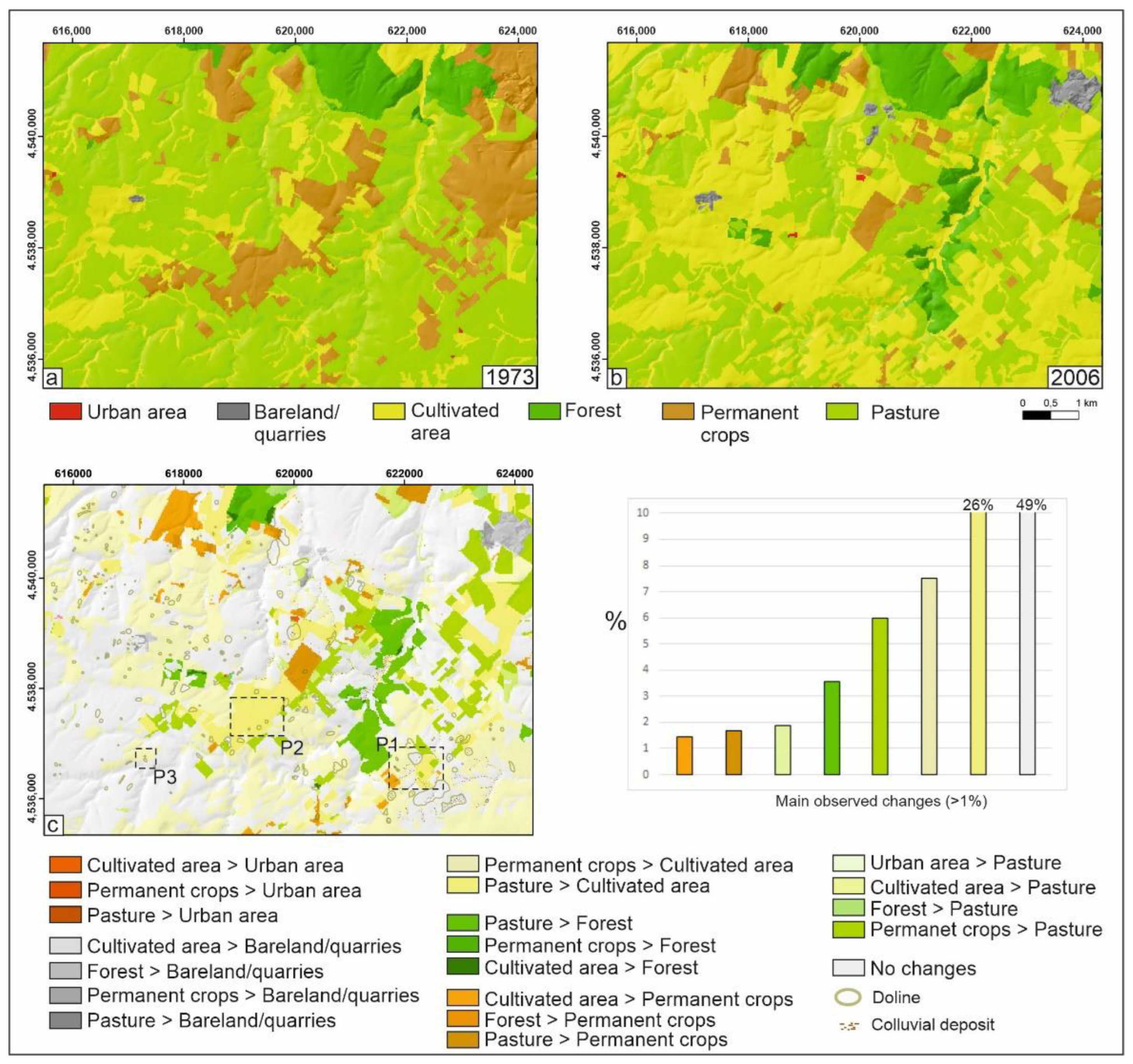
From 1973 to 2006, there was a limited increase in urban areas and in land exploited for excavation (quarries) (Table 3). There was also a modest increase in dense vegetation (roughly 213 ha), classified as forest, corresponding to almost 4% of the area. In 1973 the predominant land cover classes were pasture and permanent crops, while in 2006, we see an extensive presence of cultivated areas. This is ascribable to the most prominent change observed, namely the increase in cultivated areas (some 30%), meaning almost 1715 ha of new land was converted towards cultivation. Overall, cultivated areas in 1973 had an extension that was a quarter of the extension of the pasture lands, but in 2006 this difference was completely erased, and they came to have comparable extension with the cultivated areas that exceeded the pasture lands by 725 ha. These changes occurred at the expense of permanent crops and pasture, which reduced their extension by 11% and 24%, respectively.
The above numbers testify to the great changes that occurred, most of which were caused by stone clearing and crushing during the 1990s.
A transition matrix was also computed to characterize each specific transformation from one class to another (Table 4). The most relevant transitions were those related to permanent crops and pasture that were converted to cultivated areas, together with the permanent crops cultivated towards pasture. There was also an increase in forested area (mainly dense vegetation) at the expense of pasture lands. To a lesser extent, a conversion of cultivated areas to pasture and permanent crops was also observed. Transitions involving urban areas appear to be of secondary importance and can be related to some rural constructions (visible in 1973) that, from the observation of the 2006 images, resulted in being abandoned and/or demolished.
Information derived from the transition matrix 1973–2006 is proposed graphically in Figure 5. Looking at changes as a percentage (chart of Figure 5), almost half of the analyzed area retained the original landscape, meaning that it did not experience any change. The extraction area (quarry) was localized in the northeastern part of the study area (Figure 5b,c). The new dense vegetation occurred on the flanks of a lama with NE-SW orientation. The new pasture lands were diffuse and scattered with a certain degree of fragmentation. The conversion of pasture and permanent crops towards cultivated areas was widespread in the entire area (Figure 5c). A large part of the newly cultivated area appeared where doline, lame, and colluvial deposits were also recognized.
Land cover changes also occurred in correspondence with the presence of karst landforms. Furthermore, the interpolation of landcover changes with these elements (Table 5 and Table 6) shows that transformations occurred despite the presence of karst geomorphological elements; as a consequence, these were partially or totally modified, and their distinctive features were often obliterated in the transformation [125]. More than 23 ha of land, characterized by colluvial deposits (Table 5) and 40 ha of doline (Table 6), were converted to cultivated areas from permanent crops and pasture. Other changes with lesser extension, such as the conversion of cultivated areas to other land cover classes or permanent crops to other land cover classes, also involved colluvial deposits and dolines.
In this investigation, extensive fieldwork was utilized in association with aerial photo interpretation. The aim of the fieldwork was to verify in the field the most peculiar cases of land cover changes and karst landform obliteration. In fact, after thorough visual examination of the aerial photos from multiple years to verify the transformation or the erasure of the doline, lame, and colluvial deposit’s geomorphological characteristics, a number of sites were also checked in the field to verify the present land cover and the present state of preservation of the karst landforms. The three most explicative cases where land cover transformation determined partial or total obliteration of the karst elements were reported and described.
Figure 6 reports the case of Grave Ferratella, one of the most important caves in Apulia [119], that reached a depth of 320 m below the ground according to explorations in the 1960s [30]. From the multi-temporal aerial photo interpretation, it is possible to infer that in 1973 (a), the cave was still visible, and access to the karst system with the surrounding doline, lame, and colluvial deposits was preserved as a result of their morphological properties. Furthermore, the land cover in the area was mainly represented by crops. In 2006 (b), the cave entrance was lost, the water drainage lines, such as the lame, were not visible anymore, and the colluvial deposits were removed. The entire karst system was altered, and the land cover appears to have been converted to cultivated land. This was confirmed by the photograph recently taken in the field (c), where even though it is possible to appreciate a slight depression, it is not possible to recognize the doline boundaries, and the cave entrance has completely disappeared.
Another example is provided in Figure 7, where the land cover conversion from permanent crops (a) to cultivated (b) determines the smoothing of the karst morphological elements: namely, doline and lame are no longer visible, and, as a consequence, the drainage system is obliterated. From the photograph shown in Figure 7c it is possible to also notice that the lame flat bottom is used for cultivation.
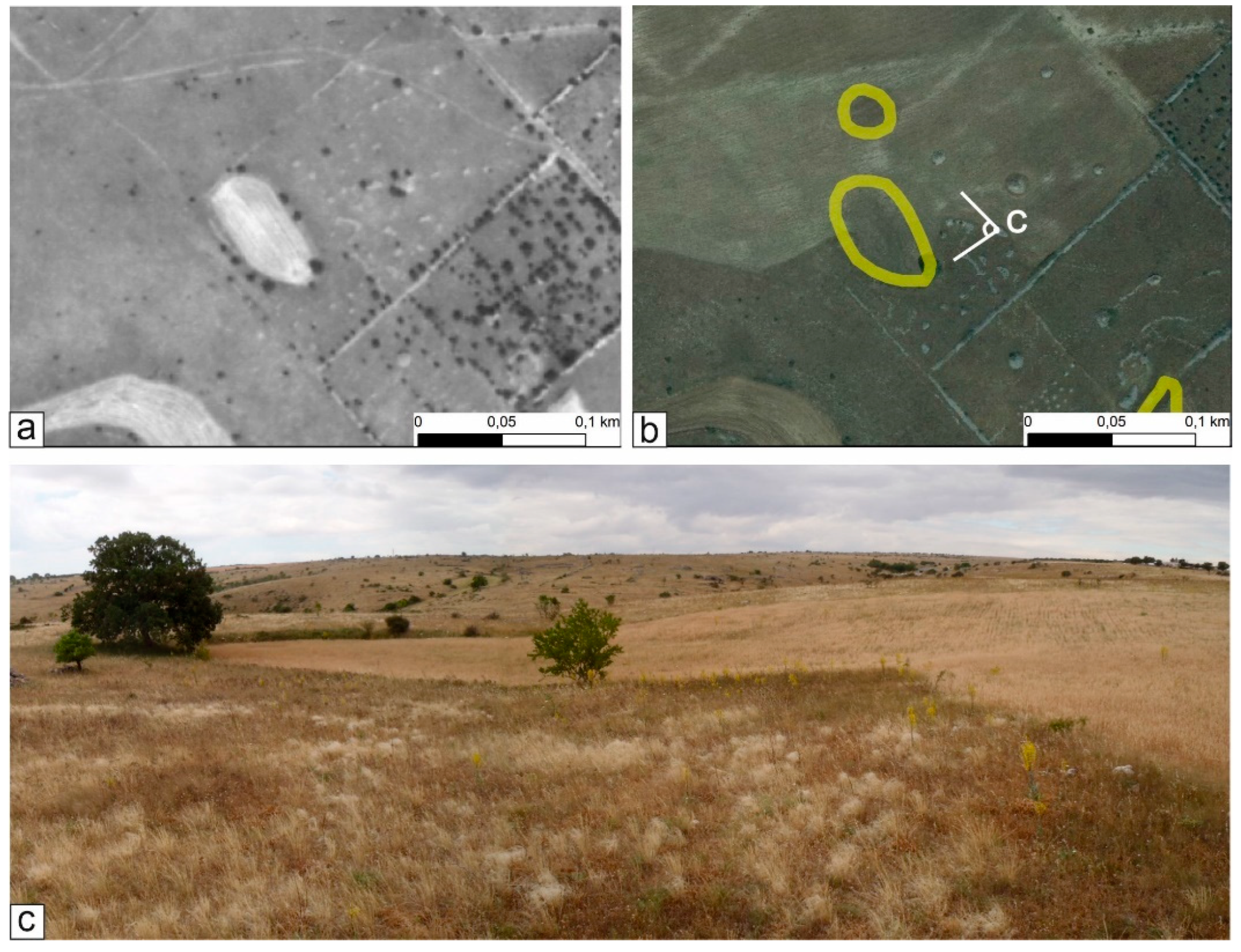
The last example (Figure 8) shows that in 1973 cultivation activity was limited to the inner area of the doline, while in 2006, the area was completely exploited for cultivation. In the photo taken during the field activity, it is possible to appreciate how part of the doline borders were erased by agricultural practice, especially towards the north.

4. Conclusions

The importance of using remote sensing techniques and multi-temporal analysis to evaluate karst geomorphological features and their evolution must be stressed. This tool allows us to identify elements that are not easily recognizable in the field, especially in lowland karst and settings showing heavy anthropogenic pressure. Assessment of the changes that occurred is dependent upon the availability of multi-temporal aerial photographs at a suitable resolution. This is the main problem in ascertaining land transformation at high scales and for small karst landforms such as dolines or cave entrances of limited size. Nevertheless, even when the aerial coverage does not cover the considered time span with continuity, some general information can be drawn from the analysis, as described in the case of the Murgia territory.
The conversion of land cover to cultivated areas determines the destruction of the original karst, with particular emphasis on the epikarst. This conversion is mainly attributed to the practice of stone clearing and crushing.
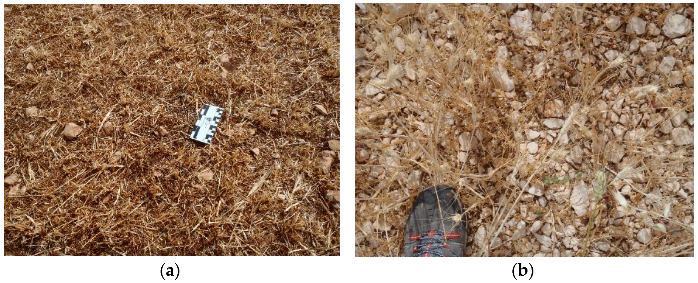
This was also observed during the field surveys, where shattered and comminated carbonate rocks were documented over lands originally characterized by bare karst and the outcropping of the carbonate rock mass (Figure 9). New parcels of pasture scattered with high fragmentation can be recognized as lands abandoned among two or more cultivated areas.
Grave Ferratella is the main example of the loss of karst landforms in Murgia, but unfortunately, it was not the only case reported. As repeatedly documented in other sectors of the Apulian karst, there are many situations where caves have been canceled or partly destroyed by human actions, notwithstanding the existing laws regarding the protection and safeguarding of karst and resources therein contained. The morphometric parameters from our analyses indicate that many endorheic basins and dolines were severely affected by the changes in land use, with a high number of canceled karst features. Even where such landforms are still present, they have been partly modified by human actions, and their boundaries significantly changed. These actions are frequently at the origin of episodes of erosion, up to the development of floods and/or debris flows, even on low-gradient slopes on the occasion of rainstorms. Thus, land use changes, in addition to producing the destruction of karst landscapes, also act in predisposing terrains to loss of soil and solid transport during rainfall events.
In times of change, both climate and anthropogenic, determining and quantifying the transformations affecting the natural landscape are the first steps to designing new policies which aim to achieve sustainable land use planning. The outcome of the present work is an explicative example to stress the need to protect the environments strongly endangered by human action and, in particular, to protect karst resources known to be peculiar for their environmental and ecological characteristics.

Supplementary Materials

The following supporting information can be downloaded at: https://www.mdpi.com/article/10.3390/land11101842/s1. Table S1: Land cover changes in hectares (ha) and as a percentage (%) from 1954 to 1973.

Author Contributions

L.P. conceived, designed the study, contributed to the compilation of figures and tables, and processed the land cover map and part of the geomorphological map; V.Z. conducted the morphometrical and distributive spatial analyses, wrote the main text, and contributed to the compilation of figures and tables; M.P. (Mariangela Pepe) realized the initial geomorphological map and analyzed it; I.S.L. wrote part of the text and contributed to data elaboration and analysis; M.P. (Mario Parise) designed and conceptualized the study and wrote the text; L.P., V.Z., and M.P. carried out the fieldwork activity. All authors contributed to the discussion, revision, and editing. All authors have read and agreed to the published version of the manuscript.

Funding

This research received no external funding.

Data Availability Statement

Not applicable.

Conflicts of Interest

The authors declare no conflict of interest.

References

  1. LeGrand, H.E. Hydrological and Ecological Problems of Karst Regions: Hydrological actions on limestone regions cause distinctive ecological problems. Science 1973, 179, 859–864. [Google Scholar] [CrossRef] [PubMed]
  2. Palmer, A.N. Cave Geology; Cave Books: Tainan, Taiwan, 2007. [Google Scholar]
  3. Bátori, Z.; Csiky, J.; Farkas, T.; Vojtkó, A.E.; Erdős, L.; Kovács, D.; Wirth, T.; Körmöczi, L.; Vojtkó, A. The conservation value of karst dolines for vascular plants in woodland habitats of Hungary: Refugia and climate change. Int. J. Speleol. 2014, 43, 15–26. [Google Scholar] [CrossRef]
  4. Chen, Z.; Auler, A.S.; Bakalowicz, M.; Drew, D.; Griger, F.; Hartmann, J.; Jiang, G.; Moosdorf, N.; Richts, A.; Stevanović, Z.; et al. The World Karst Aquifer Mapping project: Concept, mapping procedure and map of Europe. Hydrogeol. J. 2017, 25, 771–785. [Google Scholar] [CrossRef] [Green Version]
  5. Bátori, Z.; Vojtkó, A.; Keppel, G.; Tölgyesi, C.; Čarni, A.; Zorn, M.; Farkas, T.; Erdős, L.; Kiss, P.J.; Módra, G.; et al. Anthropogenic disturbances alter the conservation value of karst dolines. Biodivers. Conserv. 2020, 29, 503–525. [Google Scholar] [CrossRef] [Green Version]
  6. White, W.B. Karst hydrology: Recent developments and open questions. Engng. Geol. 2002, 65, 85–105. [Google Scholar] [CrossRef]
  7. Palmer, A.N. Understanding the hydrology of karst. Geol. Croat. 2010, 63, 143–148. [Google Scholar] [CrossRef]
  8. Gams, I. Adaptation of the karst land for the agrarian use in the Mediterranean. Problems of research and conservation (a survey). Endins 1987, 13, 65–70. [Google Scholar]
  9. Parise, M. Management of water resources in karst environments, and negative effects of land use changes in the Murge area (Apulia). Karst Dev. 2012, 2, 16–20. [Google Scholar]
  10. Gutiérrez, F. Hazards associated with karst. In Geomorphological Hazards and Disaster Prevention; Alcántara, I., Goudie, A., Eds.; Cambridge University Press: Cambridge, UK, 2010; pp. 161–175. [Google Scholar] [CrossRef]
  11. Brinkmann, R.; Parise, M. Karst Environments: Problems, Management, Human Impacts, and Sustainability. An introduction to the Special Issue. J. Cave Karst Stud. 2012, 74, 135–136. [Google Scholar] [CrossRef]
  12. Chen, F.; Bai, X.; Liu, F.; Luo, G.; Tian, Y.; Qin, L.; Li, Y.; Xu, Y.; Wang, J.; Wu, L.; et al. Analysis Long-Term and Spatial Changes of Forest Cover in Typical Karst Areas of China. Land 2022, 11, 1349. [Google Scholar] [CrossRef]
  13. Wu, L.; Wang, S.; Bai, X.; Chen, F.; Li, C.; Ran, C.; Zhang, S. Identifying the Multi-Scale Influences of Climate Factors on Runoff Changes in a Typical Karst Watershed Using Wavelet Analysis. Land 2022, 11, 1284. [Google Scholar] [CrossRef]
  14. Qi, X.; Zhang, C.; Wang, K. Comparing Remote Sensing Methods for Monitoring Karst Rocky Desertification at Sub-pixel Scales in a Highly Heterogeneous Karst Region. Sci. Rep. 2019, 9, 13368. [Google Scholar] [CrossRef] [PubMed] [Green Version]
  15. Parise, M. Natural and anthropogenic hazards in karst areas: Recognition, Analysis and mitigation. In Geological Society of London; Gunn, J., Ed.; Special Publications: London, UK, 2007; Volume 279. [Google Scholar]
  16. Kogovšek, J.; Petrič, M. Increase of vulnerability of karst aquifers due to leakage from landfills. Environ. Earth Sci. 2013, 70, 901–912. [Google Scholar] [CrossRef]
  17. Yair, A. Hillslope hydrology, water harvesting and areal distribution of some ancient agricultural systems in the northern Negev Desert. J. Arid Environ. 1983, 6, 283–301. [Google Scholar] [CrossRef]
  18. Rejec Branceli, I. Influence of modern farming on karstic landscapes. Acta Carsol. 1998, 27, 201–213. [Google Scholar]
  19. Manzano, G.; Navar, J. Processes of desertification by goats overgrazing in the Tamaulipan thornscrub (matorral) in northeastern Mexico. J. Arid Environ. 2000, 44, 1–17. [Google Scholar] [CrossRef]
  20. Kovačič, G.; Ravbar, N. Analysis of human induced changes in a karst landscape-the filling of dolines in the Kras plateau, Slovenia. Sci. Total Environ. 2013, 447, 143–151. [Google Scholar] [CrossRef]
  21. Parise, M.; Pascali, V. Surface and subsurface environmental degradation in the karst of Apulia (southern Italy). Environ. Geol. 2003, 44, 247–256. [Google Scholar] [CrossRef]
  22. Breg, M. Degradation of dolines on Logasko polje (Slovenia). Acta Carsol. 2007, 36, 223–231. [Google Scholar] [CrossRef]
  23. Zhou, W.; Beck, B.F. Management and mitigation of sinkholes on karst lands: An overview of practical applications. Environ. Geol. 2008, 55, 837–851. [Google Scholar] [CrossRef]
  24. De Waele, J. Evaluating disturbance on mediterranean karst areas: The example of Sardinia (Italy). Environ. Geol. 2009, 58, 239–255. [Google Scholar] [CrossRef]
  25. Kaligarič, M.; Ivanjšič, D. Vanishing landscape of the “classic” karst: Changed landscape identity and projections for the future. Landsc. Urban Plan. 2014, 132, 148–158. [Google Scholar] [CrossRef]
  26. Breg Valjavec, M.; Ribeiro, D.; Čarni, A. Vegetation as the bioindicator of human-induced degradation in karst landscape: Case study of waste-filled dolines. Acta Carsol. 2017, 46, 95–110. [Google Scholar] [CrossRef] [Green Version]
  27. Sharma, K.D. The hydrologic indicators of desertification. J. Arid Environ. 1998, 39, 121–132. [Google Scholar] [CrossRef]
  28. Frumkin, A. Interaction between karst, water and agriculture over the climatic gradient of Israel. Int. J. Speleol. 1999, 28, 99–110. [Google Scholar] [CrossRef]
  29. Sauro, U. A polygonal karst in the Alte Murge (Puglia, Southern Italy). Z. Geomorph. N.F. 1991, 35, 207–223. [Google Scholar] [CrossRef]
  30. Parise, M. Surface and subsurface karst geomorphology in the Murge (Apulia, southern Italy). Acta Carsol. 2011, 40, 79–93. [Google Scholar] [CrossRef]
  31. Di Santo, A.R.; Palumbo, N.; Campana, C. Fattori e prospettive per il territorio dell’Autorità di Bacino della Puglia. In Sviluppo e Conservazione Dei Servizi Degli Ecosistemi Contro Siccità e Desertificazione; Sciortino, M., Luise, A., Centritto, M., Eds.; Atti Workshop Scientifico: Roma, Italy, 2012; pp. 166–173. ISBN 978-88-8286-280-0. [Google Scholar]
  32. Cotecchia, V. Le acque sotterranee e l’intrusione marina in Puglia: Dalla ricerca all’emergenza nella salvaguardia della risorsa. Mem. Descr. Carta Geol. D’italia 2014, 92, 1228. [Google Scholar]
  33. Nicod, J. Pays et Paysages du Calcaire; Coll. SUP, P.S.F.: Paris, France, 1972. [Google Scholar]
  34. Laureano, P. Giardini di Pietra; Bollati Boringhieri: Turin, Italy, 1993. [Google Scholar]
  35. Laureano, P. Water Atlas. Traditional Knowledge to Combat Desertification; Bollati Boringhieri: Turin, Italy, 2001. [Google Scholar]
  36. Williams, P.W. The role of subcutaneous zone in karst hydrology. J. Hydrol. 1983, 61, 45–67. [Google Scholar] [CrossRef]
  37. Tallini, M.; Gasbarri, D.; Ranalli, D.; Scozzafava, M. Investigating epikarst using low frequency GPR: Example from the Gran Sasso range Central Italy. Bull. Eng. Geol. Environ. 2006, 65, 435–443. [Google Scholar] [CrossRef]
  38. Williams, P.W. The role of the epikarst in karst and cave hydrogeology: A review. Int. J. Speleol. 2008, 37, 1–10. [Google Scholar] [CrossRef] [Green Version]
  39. Cantelli, C. Misconosciute funzioni dei muretti a secco. Um. Della Pietra 1994, 9, 21–27. [Google Scholar]
  40. Kovačič, G.; Ravbar, N. Extreme hydrological events in karst areas of Slovenia, the case of the Unica River basin. Geodin. Acta 2010, 23, 89–100. [Google Scholar] [CrossRef] [Green Version]
  41. Parise, M. Flood history in the karst environment of Castellana-Grotte (Apulia, southern Italy). Nat. Hazards Earth Syst. Sci. 2003, 3, 593–604. [Google Scholar] [CrossRef]
  42. Bonacci, O.; Ljubenkov, I.; Roje-Bonacci, T. Karst flash floods: An example from the Dinaric karst, Croatia. Nat. Hazards Earth Syst. Sci. 2006, 6, 195–203. [Google Scholar] [CrossRef] [Green Version]
  43. Canora, F.; Fidelibus, M.D.; Sciortino, A.; Spilotro, G. Variation of infiltration rate through karstic surfaces due to land use changes: A case study in Murgia (SE-Italy). Eng. Geol. 2008, 99, 210–227. [Google Scholar] [CrossRef]
  44. Gill, L.W.; Naughton, O.; Johnston, P.M. Modeling a network of turloughs in lowland karst. Water Resour. Res. 2013, 49, 3487–3503. [Google Scholar] [CrossRef]
  45. Martinotti, M.E.; Pisano, L.; Marchesini, I.; Rossi, M.; Peruccacci, S.; Brunetti, M.T.; Melillo, M.; Amoruso, G.; Loiacono, P.; Vennari, C.; et al. Landslides, floods and sinkholes in a karst environment: The 1–6 September 2014 Gargano event, southern Italy. Nat. Hazards Earth Syst. Sci. 2017, 17, 467–480. [Google Scholar] [CrossRef] [Green Version]
  46. Parise, M.; Sammarco, M. The historical use of water resources in karst. Environ. Earth Sci. 2015, 74, 143–152. [Google Scholar] [CrossRef]
  47. English, P.W. The origin and spread of qanats in the Old World. Proc. Am. Philos. Soc. 1968, 112, 170–181. [Google Scholar]
  48. Beaumont, P. Qanat systems in Iran. Hydrol. Sci. J. 1971, 16, 39–50. [Google Scholar] [CrossRef]
  49. Ahmed, A.T. Water Quality for Irrigation and Drinking Water Use of Aflaj in Oman. Water Sci. Technol. 2015, 15, 421–428. [Google Scholar] [CrossRef]
  50. Yazdi, S.; Asghar, A.; Khaneiki, M.L. Qanat Knowledge: Construction and Maintenance; Springer: Dordrecht, The Netherlands, 2017. [Google Scholar]
  51. Valipour, M.; Abdelkader, T.A.; Antoniou, G.P.; Sala, R.; Parise, M.; Salgot, M.; Sanaan Bensi, N.; Angelakis, A.N. Sustainability of underground hydro-technologies: From ancient to modern times and toward the future. Sustainability 2020, 12, 8983. [Google Scholar] [CrossRef]
  52. Canora, F.; Fidelibus, M.D.; Spilotro, G. Hydrogeological implications of man-made agricultural transformations of the karstic soil textures of Alta Murgia (Puglia, Southern Italy). Geophys. Res. Abstr. 2005, 7, 10573. [Google Scholar]
  53. Parise, M. The impacts of quarrying in the Apulian karst. In Advances in Research in Karst Media; Carrasco, F., La Moreaux, J.W., Duran Valsero, J.J., Andreo, B., Eds.; Springer: Berlin/Heidelberg, Germany, 2010; pp. 441–447. [Google Scholar]
  54. Parise, M.; Caldara, M.; Festa, V.; Francescangeli, R.; Iurilli, V.; Mastronuzzi, G.A.; Nicoletti, D.; Sabato, L.; Spalluto, L.; Tarantini, F.; et al. Establishing a Geopark in Alta Murgia (Italy). In Proceedings for Conservation of Fragile Karst Resources; Kambesis, P., Singer, A., Bledsoe, L.A., Eds.; August: Atlanta, GA, USA, 2020; Volume 18–20, p. 19. [Google Scholar]
  55. Tropeano, M.; Caldara, M.; Festa, V.; Fiore, A.; Francescangeli, R.; Iurilli, V.; Mastronuzzi, G.A.; Nicoletti, D.; Parise, M.; Sabato, L.; et al. We have a dream: Murge, the lost continent in southern Italy as a Geopark! In Proceedings of the 2020 Oxford Geoheritage Virtual Conference, 25–29 May 2020; 2020, pp. 59–60. [Google Scholar]
  56. Pisano, L.; Zumpano, V.; Malek, Ž.; Rosskopf, C.M.; Parise, M. Variations in the susceptibility to landslides, as a consequence of land cover changes: A look to the past, and another towards the future. Sci. Total Environ. 2017, 601, 1147–1159. [Google Scholar] [CrossRef] [PubMed]
  57. Soeters, R.; van Westen, C.J. Slope instability recognition, analysis, and zonation. In Landslides: Investigation and Mitigation: Special Report 247 (TRANSPORTATION RESEARCH BOARD); Turner, A.K., Schuster, R.L., Eds.; The National Academy Press: Washington, DC, USA, 1996; pp. 129–177. [Google Scholar]
  58. Spalluto, L.; Fiore, A.; Miccoli, M.N.; Parise, M. Activity maps of multi-source mudslides from the Daunia Apennines (Apulia, southern Italy). Nat. Hazards 2021, 106, 277–301. [Google Scholar] [CrossRef]
  59. Calcaterra, D.; Parise, M. Landslide types and their relationships with weathering in a Calabrian basin, southern Italy. Bull. Eng. Geol. Environ. 2005, 64, 193–207. [Google Scholar] [CrossRef]
  60. Calcaterra, D.; Parise, M. Weathering as a predisposing factor to slope movements: An introduction. In Weathering as a Predisposing Factor to Slope Movements; Engineering Geology Special Publication no. 23; Calcaterra, D., Parise, M., Eds.; Geological Society of London: London, UK, 2010; Volume 23, pp. 1–4. [Google Scholar]
  61. Kundu, S.; Aggarwal, S.P.; Kingma, N.C.; Mondal, A.; Khare, D. Flood monitoring using microwave remote sensing in a part of Nuna river basin, Odisha, India. Nat. Hazards 2015, 76, 123–138. [Google Scholar] [CrossRef]
  62. Arvind, C.S.; Vanjare, A.; Omkar, S.N.; Senthilnath, J.; Mani, V.; Diwakar, P.G. Flood assessment using multi-temporal Modis satellite images. Procedia Comput. Sci. 2016, 89, 575–586. [Google Scholar] [CrossRef] [Green Version]
  63. Garfì, G.; Bruno, D.; Calcaterra, D.; Parise, M. Fan morphodynamics and slope instability in the Mucone River basin (Sila Massif, southern Italy): Significance of weathering and role of land use changes. Catena 2007, 69, 181–196. [Google Scholar] [CrossRef]
  64. Scorpio, V.; Andreoli, A.; Zaramella, M.; Moritsch, S.; Theule, J.; Dell’Agnese, A.; Muhar, S.; Borga, M.; Bertoldi, W.; Comiti, F. Restoring a glacier-fed river: Past and present morphodynamics of a degraded channel in the Italian Alps. Earth Surf. Process. Landf. 2020, 45, 2804–2823. [Google Scholar] [CrossRef]
  65. Festa, V.; Fiore, A.; Parise, M.; Siniscalchi, A. Sinkhole evolution in the Apulian karst of southern Italy: A case study, with some considerations on sinkhole hazards. J. Cave Karst Stud. 2012, 74, 137–147. [Google Scholar] [CrossRef]
  66. Doctor, D.H.; Young, J.A. An evaluation of Automated Gis Tools for Delineating Karst Sinkholes and Closed Depressions From1-Meter Lidar-Derived Digital Elevation Data. In NCKRI Symposium 2, Proceedings of the 13th Multidisciplinary Conference on Sinkholes & the Engineering and Environmental Impacts of Karst, Calsbad, New Mexico, 6–10 May 2013; National Cave and Karst Research Institute: Carlsbad, NM, USA, 2013; pp. 449–458. [Google Scholar]
  67. Florea, L. Using state-wide GIS data to identify the coincidence between sinkholes and geologic structure. J. Cave Karst Stud. 2005, 67, 120–124. [Google Scholar]
  68. Li, S.; MacMillan, R.A.; Lobb, D.A.; McConkey, B.G.; Moulin, A.; Fraser, W.R. Lidar DEM error analyses and topographic depression identification in a hummocky landscape in the prairie region of Canada. Geomorphology 2011, 129, 263–275. [Google Scholar] [CrossRef]
  69. Zhu, J.; Taylor, T.P.; Currens, J.C.; Crawford, M.M. Improved karst sinkhole mapping in Kentucky using LiDAR techniques: A pilot study in Floyds fork watershed. J. Cave Karst Stud. 2014, 76, 207–216. [Google Scholar] [CrossRef]
  70. Zumpano, V.; Pisano, L.; Parise, M. An integrated framework to identify and analyze karst sinkholes. Geomorphology 2019, 332, 213–225. [Google Scholar] [CrossRef]
  71. Pieri, P. Principali caratteri geologici e morfologici delle Murge. Boll. Gr. Spel. Martina Franca, Murgia Sotter. 1980, 2, 13–19. [Google Scholar]
  72. Doglioni, C.; Mongelli, F.; Pieri, P. The Puglia uplift (SE Italy): An anomaly in the foreland of the Apenninic sub- duction due to buckling of a thick continental lithosphere. Tectonics 1994, 13, 1309–1321. [Google Scholar] [CrossRef]
  73. Teofilo, G.; Gioia, D.; Spalluto, L. Integrated geomorphological and geospatial analysis for mapping fluvial landforms in Murge basse karst of Apulia (Southern Italy). Geosci. 2019, 9, 418. [Google Scholar] [CrossRef] [Green Version]
  74. Pepe, M.; Parise, M. Structural control on development of karst landscape in the Salento Peninsula (Apulia, SE Italy). Acta Carsol. 2014, 43, 101–114. [Google Scholar] [CrossRef]
  75. Ciaranfi, N.; Pieri, P.; Ricchetti, G. Note alla Carta Geologica delle Murge e del Salento, scala 1:250,000. Mem. Soc. Geol. It. 1988, 41, 449–460. [Google Scholar]
  76. Tropeano, M.; Sabato, L.; Pieri, P.; Doglioni, C. Geodynamic and stratigraphic history of the Bradanic Trough (south Apennines Foredeep–Italy). In Proceedings of the 15th International Sedimentological Congress, Alicante, Spain, 12–17 April 1998; pp. 772–773. [Google Scholar]
  77. Tropeano, M.; Sabato, L. Response of Plio-Pleistocene mixed bioclastic-lithoclastic temperate-water carbonate systems to forced regressions: The Calcarenite di Gravina Formation, Puglia, SE Italy. In Sedimentary Responses to Forced Regressions; Hunt, D., Gawthorpe, R.L., Eds.; Geological Society: London, UK, 2000; spec. publ.; pp. 217–243. [Google Scholar]
  78. Pieri, P.; Festa, V.; Moretti, M.; Tropeano, M. Quaternary tectonic activity of the Murge area (Apulian foreland-Southern Italy). Ann. Geofis. 1997, 40, 1395–1404. [Google Scholar] [CrossRef]
  79. Festa, V. Cretaceous structural features of the Murge area (Apulian Foreland, Southern Italy). Ecol. Geol. Helv. 2003, 96, 11–22. [Google Scholar]
  80. Waltham, T.; Bell, F.; Culshaw, M. Sinkholes and Subsidence. Karst and Cavernous Rocks in Engineering and Construction; Springer: Berlin/Heidelberg, Germany, 2005. [Google Scholar]
  81. Gutiérrez, F.; Parise, M.; De Waele, J.; Jourde, H. A review on natural and human-induced geohazards and impacts in karst. Earth-Sci. Rev. 2014, 138, 61–88. [Google Scholar] [CrossRef]
  82. Parise, M. Sinkholes, Subsidence and Related Mass Movements. In Treatise on Geomorphology, Vol. 5; Shroder, J.J.F., Ed.; Elsevier: Amsterdam, The Netherlands; Academic Press: Cambridge, MA, USA, 2022; pp. 200–220. ISBN 9780128182345. [Google Scholar] [CrossRef]
  83. Parise, M.; Federico, A.; Delle Rose, M.; Sammarco, M. Karst Terminology in Apulia (Southern Italy). Acta Carsol. 2003, 32, 65–82. [Google Scholar] [CrossRef]
  84. Castiglioni, B.; Sauro, U. Large collapse dolines in Puglia (southern Italy): The cases of “Dolina Pozzatina” in the Gargano Plateau and of “Puli” in the Murge. Acta Carsol. 2000, 29, 83–93. [Google Scholar] [CrossRef]
  85. Pepe, M.; Parise, M. La zona dei puli di Ruvo: Idro-geomorfologia carsica e assetto strutturale. In XVI Incontro di Speleologia Regionale; Castellana Grotte: Bari, Italy, 2011; pp. 1–14. [Google Scholar]
  86. Simone, O.; Fiore, A. Five Large Collapse Dolines in Apulia (Southern Italy)—The Dolina Pozzatina and the Murgian Puli. Geoheritage 2014, 6, 291–303. [Google Scholar] [CrossRef]
  87. Pisano, L.; Zumpano, V.; Liso, I.S.; Parise, M. Geomorphological and structural characterization of the ‘Canale di Pirro’ polje, Apulia (Southern Italy). J. Maps 2020, 16, 479–487. [Google Scholar] [CrossRef]
  88. Parise, M. Modern resource use and its impact in karst areas–mining and quarrying. Z. Fur Geomorphol. 2016, 60, 199–216. [Google Scholar] [CrossRef]
  89. Rocchini, D.; Di Rita, A. Relief effects on aerial photos geometric correction. Appl. Geogr. 2005, 25, 159–168. [Google Scholar] [CrossRef]
  90. Bauer, C. Analysis of dolines using multiple methods applied to airborne laser scanning data. Geomorphology 2015, 250, 78–88. [Google Scholar] [CrossRef]
  91. Bracchetti, L.; Carotenuto, L.; Catorci, A. Land-cover changes in a remote area of central Apennines (Italy) and management directions. Landsc. Urban Plan. 2012, 104, 157–170. [Google Scholar] [CrossRef]
  92. Rocchini, D.; Perry, G.L.W.; Salerno, M.; Maccherini, S.; Chiarucci, A. Landscape change and the dynamics of open formations in a natural reserve. Landsc. Urban Plan. 2006, 77, 167–177. [Google Scholar] [CrossRef]
  93. Pelorosso, R.; Della Chiesa, S.; Tappeiner, U.; Leone, A.; Rocchini, D. Stability analysis for defining management strategies in abandoned mountain landscapes of the Mediterranean basin. Landsc. Urban Plan. 2011, 103, 335–346. [Google Scholar] [CrossRef]
  94. Denizman, C. Morphometric and spatial distribution parameters of karstic depressions, lower Suwannee river basin, Florida. J. Cave Karst Stud. 2003, 65, 29–35. [Google Scholar]
  95. Wall, J.; Bohnenstiehl, D.W.R.; Wegmann, K.W.; Levine, N.S. Morphometric comparisons between automated and manual karst depression inventories in Apalachicola National Forest, Florida, and Mammoth Cave National Park, Kentucky, USA. Nat. Hazards 2017, 85, 729–749. [Google Scholar] [CrossRef]
  96. De Carvalho Junior, O.A.; Guimarães, R.F.; Montgomery, D.R.; Gillespie, A.R.; Gomes, R.A.T.; Martins, É.D.S.; Silva, N.C. Karst depression detection using ASTER, ALOS/PRISM and SRTM-derived digital elevationmodels in the Bambuí group, Brazil. Remote Sens. 2013, 6, 330–351. [Google Scholar] [CrossRef] [Green Version]
  97. Kemmerly, P.R. Modeling doline populations with logistic growth functions. Earth Surf. Process. Landf. 2006, 32, 587–601. [Google Scholar] [CrossRef]
  98. Basso, A.; Bruno, E.; Parise, M.; Pepe, M. Morphometric analysis of sinkholes in a karst coastal area of southern Apulia (Italy). Environ. Earth Sci. 2013, 70, 2545–2559. [Google Scholar] [CrossRef]
  99. Gao, Y.; Alexander, E.C.; Barnes, R. Karst database implementation in Minnesota: Analysis of sinkhole distribution. Environ. Geol. 2005, 47, 1083–1098. [Google Scholar] [CrossRef]
  100. Chaudhuri, D.; Samal, A. A simple method for fitting of bounding rectangle to closed regions. Pattern Recogn. 2007, 40, 1981–1989. [Google Scholar] [CrossRef]
  101. Kobal, M.; Bertoncelj, I.; Pirotti, F.; Dakskobler, I.; Kutnar, L. Using lidar data to analyse sinkhole characteristics relevant for understory vegetation under forest cover-Case study of a high karst area in the Dinaric mountains. PLoS ONE 2015, 10, e0122070. [Google Scholar] [CrossRef] [PubMed] [Green Version]
  102. Wu, Q.; Deng, C.; Chen, Z. Automated delineation of karst sinkholes from LIDAR-derived digital elevation models. Geomorphology 2016, 266, 1–10. [Google Scholar] [CrossRef]
  103. Gams, I. Doline morphogenetical processes from global and local viewpoints. Acta Carsol. 2000, 29, 123–138. [Google Scholar]
  104. Beck, B. Soil piping and sinkhole failures. In Encyclopedia of Caves, 2nd ed.; Culver, D.C., White, W.B., Eds.; Elsevier Academic Press: Cambridge, MA, USA, 2005; pp. 521–526. [Google Scholar]
  105. Colamonico, C. Il Pulo di Altamura. Mondo Sotter. 1917, 12, 65–76. [Google Scholar]
  106. Delle Rose, M.; Federico, A.; Parise, M. Sinkhole genesis and evolution in Apulia, and their interrelations with the anthropogenic environment. Nat. Hazards Earth Syst. Sci. 2004, 4, 747–755. [Google Scholar] [CrossRef] [Green Version]
  107. Gams, I. The polje: The problem of definition. Z. Geomorphol. 1978, 22, 170–181. [Google Scholar]
  108. Šustersic, F.; Šustersic, S. Formation of the CerkniŠeica and the flooding of CerkniŠko polje. Acta Carsol. 2003, 32, 121–136. [Google Scholar]
  109. Bonacci, O. Poljes. In Encyclopedia of Caves and Karst Science; Gunn, J., Ed.; Fitzroy Dearborn: Chicago, LL, USA, 2004; pp. 599–600. [Google Scholar]
  110. Parise, M. Geomorphology of the Canale di Pirro karst polje (Apulia, southern Italy). Z. Für Geomorphol. N.F. 2006, 147, 143–158. [Google Scholar]
  111. Liso, I.S.; Chieco, M.; Fiore, A.; Pisano, L.; Parise, M. Underground geosites and caving speleotourism: Some considerations, from a case study in Southern Italy. Geoheritage 2020, 12, 13. [Google Scholar] [CrossRef]
  112. Parise, M.; Benedetto, L.; Chieco, M.; Fiore, A.; Lacarbonara, M.; Liso, I.S.; Masciopinto, C.; Pisano, L.; Riccio, A.; Vurro, M. First outcomes of a project dedicated to monitoring groundwater resources in Apulia, southern Italy. In Eurokarst 2018. Advances in the Hydrogeology of Karst and Carbonate Reservoirs; Bertrand, C., Denimal, S., Steinmann, M., Renard, P., Eds.; Springer: Berlin/Heidelberg, Germany, 2020; Advances in Karst Science; pp. 243–249. ISBN 978-3-030-14014-4. [Google Scholar]
  113. Molerio León, L.; Parise, M. Managing environmental problems in Cuban karstic aquifers. Environ. Geol. 2009, 58, 275–283. [Google Scholar] [CrossRef]
  114. Huang, W.; Deng, C.J.; Day, M. Differentiating tower karst (fenglin) and cockpitkarst (fengcong) using DEM contour, slope, and centroid. Environ. Earth Sci. 2014, 72, 407–416. [Google Scholar]
  115. Lei, M.; Gao, Y.; Jiang, X.; Guan, Z. Mechanism analysis of sinkhole formation at Maohe village, Liuzhou city, Guangxi province, China. Environ. Earth Sci. 2016, 75, 1–11. [Google Scholar] [CrossRef]
  116. Durn, G. Terra rossa in the Mediterranean region: Parent materials, composition and origin. Geol. Croat. 2003, 56, 83–100. [Google Scholar] [CrossRef]
  117. Lopez, N.; Spizzico, V.; Parise, M. Geomorphological, pedological, and hydrological characteristics of karst lakes at Conversano (Apulia, southern Italy) as a basis for environmental protection. Environ. Geol. 2009, 58, 327–337. [Google Scholar] [CrossRef]
  118. Larocca, F.; Bernocco, S. Grotte e voragini nel territorio comunale di Ruvo di Puglia (Ba). Itiner. Speleol. 1988, 3, 33–40. [Google Scholar]
  119. Iurilli, V.; Ruina, G. Indagini geologiche e geofisiche sulla Grave “Ferratella” in agro di Ruvo di Puglia (Bari). Itiner. Speleol. 1999, 8, 23–30. [Google Scholar]
  120. Bellaccio, G.; Pagliarulo, R.; Talucci, G.; Zezza, F. Le caratteristiche fisico-meccaniche e termiche del “Marmo” di Puglia. Rass. Tec. Puglies–Contin. 1982, 4, 3–9. [Google Scholar]
  121. Cotecchia, V.; Radina, B.; Zezza, F. Marmi di Puglia; Istituto Geografico De Agostini: Novara, Italy, 1982. [Google Scholar]
  122. Laviano, R. I materiali lapidei pugliesi: Loro utilizzo e alterazione nei Beni Culturali. In Memorie di Scienze Fisiche e Naturali; Accademia Nazionale delle Scienze: Rome, Italy, 2006; Volume 30, pp. 205–248. [Google Scholar]
  123. Shaban, A.; Darwich, T. The role of sinkholes in groundwater recharge in the high mountains of Lebanon. J. Environ. Hydrol. 2011, 19, 1–11. [Google Scholar]
  124. Hofierka, J.; Gallay, M.; Bandura, P.; Šašak, J. Identification of karst sinkholes in a forested karst landscape using airborne laser scanning data and water flow analysis. Geomorphology 2018, 308, 265–277. [Google Scholar] [CrossRef]
  125. Vennari, C.; Salvati, P.; Bianchi, C.; Casarano, D.; Parise, M.; Basso, A.; Marchesini, I. ARcReoDatHa: Apulian regional GeoDatabase for geo-hydrological hazards. J. Environ. Manag. 2022, 322, 116051. [Google Scholar] [CrossRef]
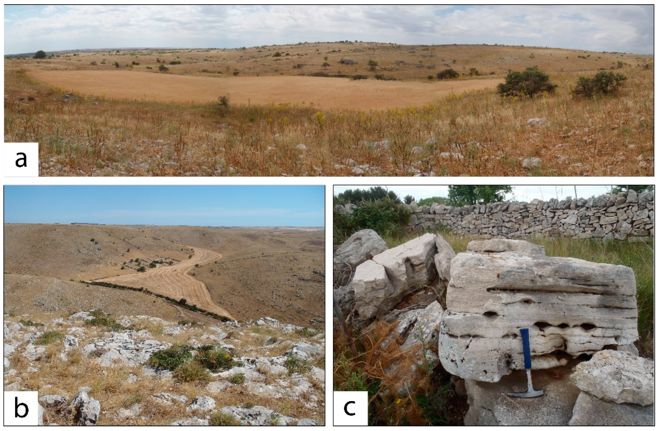
Figure 2. Typical karst landforms of the study area: (a) wide depression, surrounded by low hills in carbonate rocks; (b) a typical lama, with its bottom cultivated; (c) karst conduits and channels in outcrops of Cretaceous limestones.
Land 11 01842 g002
Figure 3. Geomorphological map of the main karst landforms in the study area.
Land 11 01842 g003
Figure 4. Percentage of doline shape, classified on the basis of the Elongation Ratio values as circular (ER < 1.05), sub-circular (1.05 < ER ≤ 1.21), elliptical (1.21 < ER ≤ 1.65), sub-elliptical (1.65 < ER ≤ 1.8), and elongated (ER > 1.8).
Land 11 01842 g004
Figure 5. Overview of the land cover in 1973 (a) and 2006 (b), and land cover changes (c) observed in the period 1973–2006. The histogram shows the percentage of land cover transitions greater than 1% and the percentage of the stable area. P1 to P3 sites in Figure 5c refer to the sites shown in Figure 6, Figure 7 and Figure 8, respectively.
Land 11 01842 g005
Figure 6. Multi-temporal observation at the site of the cave “Grave Ferratella”: (a) 1973 aerial photo; (b) 2006 orthophoto (letter c indicates view of sight of the photograph below); and (c) photograph taken in summer 2021. Location shown in Figure 5c (site P1).
Land 11 01842 g006
Figure 7. Multi-temporal observation of site P2 (location shown in Figure 5c): (a) 1973 aerial photo; (b) 2006 orthophoto (letter c indicates view of sight of the photograph below); and (c) photograph taken in summer 2021.
Land 11 01842 g007
Figure 8. Multi-temporal observation of site P3 (location shown in Figure 5c): (a) 1973 aerial photo; (b) 2006 orthophoto (letter c indicates view of sight of the photograph below); and (c) photograph taken in summer 2021.
Land 11 01842 g008
Figure 9. Shattered carbonate rocks mixed with soil as a result of stone-clearing activity, as observed during the field survey, examples from two different observation points (a,b).
Land 11 01842 g009
Table 1. Caves in the study area shown in Figure 1 (data from the regional inventory, available online: http://www.catasto.fspuglia.it/ (accessed on 17 May 2022)).
Cadastral
Number
Name Length (m) Depth (m) Entrance Elevation
(m a.s.l.)
Landscape Location
PU 444Grave Ferratella90−320483doline bottom
PU 493 *Grotta della Masseria Lago Cupo--530lama flank
PU 1258Grotta della Ferrata36−18380lama flank
PU 1259Grotta del Brigante11−2385lama flank
PU 1260Grotta delle Volpi9.5−16449lama flank
PU 1261Capovento in loc. Petronella13.5−13423lama flank
PU 1262Grava della Cavallerizza36−43445doline bottom
PU 1263Buca in loc. Jazzo Rosso1.5−5485lama flank
PU 1264Capovento di Pancia d’Aceto5.5−14380lama flank
PU 1265Capovento in loc. Cavallerizza12−25453plateau surface
PU 1268Voragine di Notarvincenzo35−84480plateau surface
* PU 493 does not exist anymore since it has been filled with stone materials.
Table 2. Morphometric parameters of dolines. ER: Elongation Ratio; CI: Circularity index.
Area (m2)PerimeterWidth (m)Length (m)ProximityERCI
MAX149,900.331783.16301.57705.531554.788.530.99
MIN84.5935.477.9113.586.951.020.24
Mean5213.95231.8151.4387.53113.811.720.82
Median1790.37166.0637.9763.1573.891.470.88
Table 3. Land cover changes in the time span from 1973 to 2006, shown in hectares (ha) and as a percentage (%).
Land Cover Class1973 (ha)2006 (ha)Δ (ha)1973%2006%Δ %
Urban area1.323.632.300.020.060.04
Bareland/quarries2.7167.5164.800.051.191.15
Cultivated area870.052585.261715.2115.3945.7330.34
Forest317.55531.01213.475.629.393.78
Permanent crops982.02339.15−642.8717.376.00−11.37
Pasture3480.022127.11−1352.9161.5537.62−23.93
Table 4. Transition matrix for the period 1973–2006, with transitions expressed in hectares (ha). Stable areas are shown in bold.
1973 (ha)2006 (ha)
Urban
Area
Bareland/
Quarries
Cultivated
Area
ForestPermanent
Crops
Pasture
Urban area0.460.000.230.000.980.58
Bareland/quarries0.002.590.120.000.000.00
Cultivated area1.617.95662.0511.0080.93106.50
Forest0.005.410.29297.220.0013.71
Permanent crops0.9835.65423.7122.29161.40338.00
Pasture0.5815.901498.87200.5195.901668.27
Table 5. Land cover changes in hectares (ha) and as a percentage (%) from 1973 to 2006 observed in correspondence of colluvial deposits.
Colluvial Deposits
Land Cover Changes
Area (ha)%
Cultivated area-Cultivated area30.4149.07
Cultivated area -> Forest0.120.19
Cultivated area-> Permanent crops1.091.77
Cultivated area -> Pasture1.732.79
Permanent crops -> Cultivated area4.957.99
Permanent crops—Permanent crops1.732.79
Permanent crops -> Pasture0.811.30
Pasture -> Cultivated area18.6030.02
Pasture -> Pasture2.534.09
Table 6. Land cover changes in hectares (ha) and as a percentage (%) from 1973 to 2006 observed in correspondence of dolines.
Doline
Land Cover Changes
Area (ha)%
Cultivated Area—Cultivated Area36.6930.71
Cultivated area -> Forest2.532.12
Cultivated area-> Permanent crops2.071.74
Cultivated area -> Pasture1.901.59
Forest-Forest0.400.34
Permanent crops -> Cultivated area12.8410.75
Permanent crops -> Forest0.810.68
Permanent Crops—Permanent Crops4.323.62
Permanent crops -> Pasture2.251.88
Pasture -> Cultivated area27.8823.34
Pasture -> Forest0.290.24
Pasture -> Cultivated area0.170.14
Pasture -> Pasture27.3022.85
Publisher’s Note: MDPI stays neutral with regard to jurisdictional claims in published maps and institutional affiliations.