Abstract
This study analysed the history of anthropogenically created alpine pastures from the 15th century to the present, as landscape resources for the chamois reintroduction in the second half of the 20th century in the Western Carpathians mountain arc (Slovakia), using the example of the Ďumbier Tatras (the second highest mountain range of the arc). Analysis and reconstructions were carried out on the basis of detailed archival and field research, which showed that grazing herds in the mountain peaks from the Middle Ages to the 20th century created anthropogenically suitable and sufficiently extensive grassy habitats for the chamois reintroduction and the survival of its population. The native chamois population became extinct in the Ďumbier Tatras at the end of the last ice age (about 10,000 years ago). However, anthropogenic deforestation has once again created suitable conditions for its distribution. In the 20th century, a new factor emerged, namely nature conservation and the proclamation of a national park, which meant the end of grazing in the alpine environment and the onset of succession. In the second half of the 20th century, modern tourism became another negative factor for the relocated Alpine chamois population, from the High Tatras back to its quasi-original environment. Tourism development was related to the construction of extensive infrastructure and superstructure in the chamois habitats in the Chopok and Ďumbier massifs. At present, therefore, the preservation of these ‘anthropogenic’ habitats requires active conservation and landscape management.
1. Introduction
The natural development of the vegetation in the highest mountain regions of the Western Carpathians caused the disappearance of suitable ecological conditions and the loss of habitats native to the Alpine chamois in the era following the ice age. At the turn of the era, when natural deciduous and mixed forests spread over this European geographical area, alpine meadows were no longer common; they had begun to fragmentize and eventually disappeared. In the peak regions of the Ďumbier Tatras, alpine meadow areas have spread only minimally.
The Ďumbier Tatras, the second-highest mountain range in the Western Carpathians, is located in Central Europe, more precisely in the middle of Slovakia (Figure 1a,b). They have a distinctly elongated shape in the west-east direction; their length is approximately 50 km, they are 15 to 30 km wide and cover around 669 km2. The highest peak is Ďumbier (2043 m above sea level) and the relative height of the main ridge ranges from 700 to 1350 m. The internal ruggedness of the range landscape is 600 to 800 m while its ruggedness at the edges is 300 to 500 m. In general, the slope gradient is 20–30°. However, this can be even higher in ridge areas.
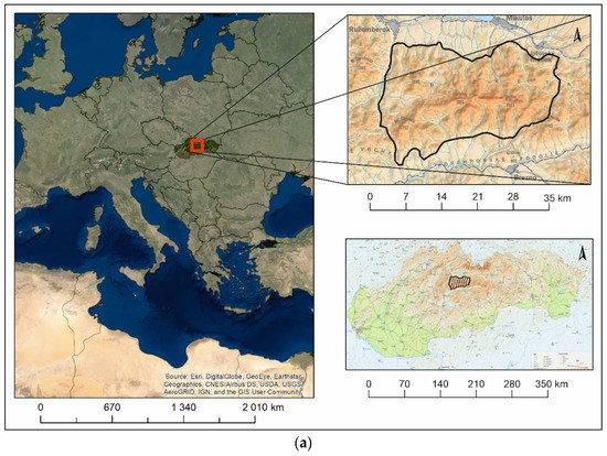
Figure 1.
(a) Location and delimitation of the studied area of the Ďumbier Tatras mountain ranges within Slovakia and Europe (source: Esri; National atlas of Slovak Republic, 2002). (b) Main Ďumbier Tatras mountain range—central part of studied area (west part A, east part B). source: ZB Gis.
The original mountain forests kept their compactness until the Middle Ages. In connection with the formation of new settlements, and the boom in mining and forestry in the 13th century, people began to drastically interfere with high mountain forests. In the 14th, but especially the 15th centuries, intensive mountain pastoralism became an important factor leading to deforestation, the spread of high mountain grasslands, and the shift of the upper forest boundary from its natural altitude (approx. 1800 m a. s. l.) to around 1400 m and often even lower. In the 16th century, mountain deforestation was so extensive that in the Ďumbier Tatras (but also in other Western Carpathians mountains), anthropogenically created mountain non-forest plant communities were formed and used as pastures.
Based on historical and geographical analyses and field research, this study aimed to reconstruct the transformation of the mountain landscape under the influence of anthropogenic activities (driving forces) as a potential habitat for the Alpine chamois. The goal was to point out that the Alpine chamois reintroduced in the Ďumbier Tatras populate an anthropogenically created landscape despite them living in a national park. Our ambition was to analyse their spread (extinction and reintroduction) in the Ďumbie Tatras (the current Low Tatras National Park) in connection with the anthropogenic transformation of the vegetation of its natural habitat. The aim of the second part of the study was a synthesis-based indication that, in principle, the anthropogenically created and conditioned alpine landscape still has several negative drivers (especially tourism) that threaten the current anthropogenic habitats of the Alpine chamois in the Ďumbier Tatras.
The chamois (genus Rupicapra), as an interesting part of the alpine environment, was often the subject of several successful introductions, motivated by its hunting use as a desirable trophy animal, but also by conservation translocations [1,2]. Conservation translocations of wild species are the deliberate movement of organisms from one site to another where the primary objective is a conservation benefit—rescuing and re-establishing extirpated populations [3,4]. The chamois indigenous distribution contains mountain ranges in southwestern Asia, southeastern Europe, the Carpathians, Chartreuse massif and the Alps. For the above reasons, its translocations took place in many areas of Europe [1,5,6,7], but also in South America [8], and New Zealand [9].
The current distribution of Rupicapra spp. has been shaped by the natural fragmentation of suitable habitats and the resulting constraints on gene flow between different populations [10].
There are currently four separate populations (evolutionary significant units) of chamois in Slovakia. The distribution range of the native Tatra chamois (Rupicapra rupicapra tatrica, Blahout 1972), the flagship species of nature conservation, consist of alpine areas in the Západné, Vysoké and Belianske Tatry Mts. (northern Slovakia). This subspecies was reintroduced in the Nízke Tatry Mts. between 1969 and 1976 [11,12,13,14,15]. Two other chamois populations in Slovakia (in Slovak Paradise and Vel’ká Fatra) were created by the introduction of individuals of alpine origin (Rupicapra rupicapra rupicapra) from the Czech Republic [16,17]. This study dealt with the analysis of these anthropogenically created habitats based on the research of medieval and early modern documentary archival materials. This article evaluates the stabilization of the anthropogenic habitats suitable for the Alpine chamois throughout modern times. Thus its quasi-original environment, which disappeared centuries ago, was formed again. The final part of this study dealt with the basic historical events of the Alpine chamois reintroduction in the second half of the 20th century into these anthropogenically created Ďumbier Tatras mountain habitats.
2. Theoretical Background
The chamois are often subject to research [18]. As a rule, this research is aimed at analysing their state of health [19,20], abundance, spatial distribution, movement [21], eating habits [22], the threat represented by predators and humans [23], and the habitat of this animal itself [24,25]. Equally important is the question of reintroducing this animal into those areas where it once naturally occurred but became extinct, or placing it in new territories. Scientific research has, for example, addressed the issue of the reintroduction of chamois to other countries [1], in relation to the pressure represented by other reintroduced animals [26] and the issue of minimizing risks related to the capture of chamois for its reintroduction [27]. Moreover, the question of the causes of the chamois extinction in a certain territory [28], the anthropogenic pressure on the reintroduced chamois [29], and the genetic impact of chamois management [6] have also been addressed.
Historical and Geographical View of Natural and Anthropogenic Distribution (Introduction) of Chamois in Europe and the Western Carpathians
Chamois (genus Rupicapra, subfamily Caprinae, family Bovidae) are mountain goats living predominantly in the flat and fragmented open habitats of rocks with steep slopes, on alpine meadows, or in the mixed and coniferous forests of the middle to high mountain ranges of Southern or Central Europe and the Middle East (Turkey, the Caucasus) [30]. In addition to several European locations, they have also been artificially introduced to New Zealand and Argentina [28,31]. Chamois have perfectly adapted to life in the high mountains anatomically, physiologically and behaviourally.
The ancestors of the tribe Rupicaprini probably evolved in the Miocene in Asia and underwent two different radiations (the tribe appears to be polyphyletic). In the late Miocene and early or middle Pliocene they spread to Europe and North America. The genus Rupicapra developed during the Middle and Late Pleistocene in Western Eurasia and penetrated the western areas along the local mountain massifs (the Carpathians, the Alps) [32]. Paleontologically documented chamois findings date back 115,000 years to the last interglacial period (Eemian or Riss-Würm) when the chamois lived alongside Neanderthal man. The taxonomy of the genus is subject to continuous review. Literature from the turn of the 20th and 21st centuries recognizes two species of this genus: the Mediterranean chamois Rupicapra pyrenaica (Bonaparte, 1845) from southwest Europe and the Alpine chamois R. rupicapra (Linnaeus 1768) from Central and Eastern Europe [33]. They differ craniometrically, genetically, morphologically and behaviourally. Both species already existed on the Old Continent at the beginning of the Würm glaciation (their speciation occurred before it). R. pyrenaica, which shows more traditional features, was geographically divided into the Iberian and Central and South Apennine groups in the early Würm, whereas R. rupicapra occupied the area from the Caucasus to the Alpine arc. In Eastern Europe, the chamois adapted to the cold climate and then migrated westward due to the onset of a dry climate. This species has not spread to the warmer southernmost regions of Europe, which are considered to be a refugium for R. pyrenaica. Following a thorough taxonomic review, chamois populations were divided into two species—Rupicapra pyrenaica and R. rupicapra. The Mediterranean chamois (R. pyrenaica) include populations from Southwestern Europe, comprising three discontinuous subspecies: the Pyrenean Chamois R. p. pyrenaica (Bonaparte, 1845), the Abruzzo Chamois R. p. ornata (Neumann, 1899) and the Cantabrian Chamois R. p. Parva (Cabrera, 1911). The Alpine chamois (Rupicapra rupicapra, Linnaeus, 1758), which can be found in the mountainous regions of Central and Northeastern Europe and Asia Minor, has seven subspecies: Turkish Rupicapra rupicapra asiatica (Lydekker, 1908), Balkan R. r. balcanica (Bolkay, 1925), Romanian R. r. carpatica (Couturier, 1937), Carthusian R. r. cartusiana (Couturier, 1937), Caucasian R. r. caucasiaca (Lydekker, 1910), Alpine R. r. rupicapra (Linnaeus, 1758) and Tatra R. r. Tatrica (Blahout, 1971).
The territory of the Alpine chamois is currently greatly influenced by the introduction of the species to several locations in Europe and other parts of the world. The size of the territory and the distribution of the chamois in the last two centuries have been significantly influenced by inclement weather from the time the calves are born up to their first weeks of life. It is further influenced by hunting, habitat destruction, urbanization, epidemics and introduction, or reintroduction (Figure 2).
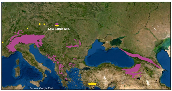
Figure 2.
Natural distribution (violet colour) and introduction of chamois in the mountains of Central Europe (yellow colour). (Based on: https://upload.wikimedia.org/wikipedia/commons/7/7f/Rupicapra_rupicapra.png (accessed on 24 August 2022)).
The subject of this study was the endemic and critically endangered Tatra chamois (Rupicapra rupicapra tatrica, [34]), which is one of the seven subspecies of the Alpine chamois (Rupicapra rupicapra). Described as an independent subspecies in 1971 by Ing. Milic Blahout, CSc., the Tatra chamois only live in the Slovak and Polish Tatras where they have been present since the ice age. Their autochthony has also been proven by Late Glacial skull fragment findings (Dryas). These were discovered in the Muráň region, the Belianske Tatras, at an altitude of 1570 m around 10,610 ± 100 years ago and in the Miętusia Cave, Poland, at an altitude of 1273 m around 16,000 years ago.
Geographically speaking, the Tatra chamois is the northernmost naturally occurring chamois population in Europe. In Slovakia, there are currently two small isolated populations living in the alpine environments of the Western and Eastern (High and Belianske) Tatras (Tatra National Park) and the Low Tatras (Low Tatras National Park).
3. Materials and Methods
During the implementation of the research objectives and the design of this study, we chose a methodological procedure consisting of several interdisciplinary methods that were divided into consecutive, logically related, or simultaneously implemented steps [35]. The emphasis was put on historical, geographical, and field research of the anthropogenically created mountain landscape. In general, we proceeded as follows (Figure 3): identification of the problem, definition of the research objective, selection of research methods, creation of a research plan, collection and analysis of data, evaluation of data, and synthesis of conclusions [36,37,38].
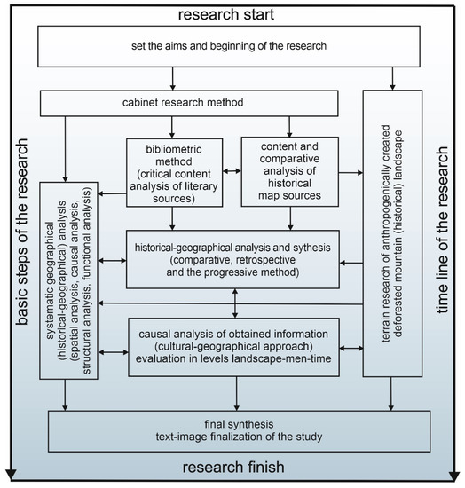
Figure 3.
Schematic representation of theoretical and methodological research and work procedures (source: authors’ research).
A fundamental step in researching the topic and processing the original scientific work was developing the historical and geographical armchair research methods. These were directly related to each other when divided into logical or simultaneously implemented sub-stages [39,40]. The starting point was the heuristics of the information database, and a critical content analysis of literary (in part also archival) sources that led to the creation of a search for information on the topic under study using the bibliometric method [41,42,43]. Following a critical content analysis of textual literary and archival sources, at the same time, we conducted a critical content and comparative analysis of historical maps [44,45,46], mapping of potential natural vegetation [47], military mapping 1–80s of the 18th century, and military mapping 2–60s of the 19th century (available online: https://maps.arcanum.com/en/browse/composite/ (accessed on 24 July 2022)). In addition, the analysis of digital CORINE Land Cover materials from the 1990s to 2018 (available online: http://copernicus.sazp.sk/#mapovy-prehliadac (accessed on 25 July 2022)) was aimed at identifying (naturally and anthropogenically) deforested peaks of the Ďumbier Tatras.
An important step in the study and analysis of anthropogenic alpine landscapes as a potential habitat for the Alpine chamois was the field research, which was based on a critical content and comparative analysis of literary (archival) and map sources. This was performed in parallel with historical and geographical analyses of the area under study. The analyses of the anthropographically created ‘turn of the century to the present day’ alpine landscape were based on the works of several authors [48,49,50,51,52].
Historical and geographical analyses and syntheses were used for the reconstructions of the development of changes in the main anthropogenic driving forces that shaped the alpine landscape of the Ďumbier Tatras from the turn of the millennium to the present day and led to the creation of suitable habitats for the reintroduction of the Alpine chamois. We used a set of historical and geographical research methods: the method of horizontal cross-sections, the comparative method, the retrospective method, and the progressive method [49,50,53,54].
Having reconstructed the development of deforested parts of the alpine landscape and identified the main anthropogenic driving forces (anthropogenic activities) that led to the formation of balds, we used the method of causal analysis [55,56]. This method is based on a cultural-geographical approach to landscape that has been used to study the causality of the historical landscape elements and phenomena researched in the context of the ‘landscape, man and time’ relationship [57].
After completion of the field research and historical and geographical syntheses, we subjected the obtained extensive database of historical and geographical information about the anthropogenically formed alpine landscape as a potential habitat for the Alpine chamois to a systemic geographical (historical plus geographical) analysis [58]. The given spatial [59], causal [55,56], structural, and functional geographical analysis [58] was further used to characterize individual objects and systems in the anthropogenically created alpine landscape and identify individual relationships and ties within and among landscape objects.
The last stage of the work consisted of final geographical syntheses, which resulted in the creation of the discussion and conclusions, and in the finalization of the study as per the submitted final textual, pictorial, and formal requirements [37,58,60].
4. Results
4.1. Original Tatra Chamois Population in the Ďumbier Tatras
The last glaciation reached its maximum in Europe around 18,000 years ago. During this period, the glacier leaned against the northern edges of the Western Carpathians, as evidenced by the remains of its frontal moraines. During this period, the chamois inhabited a larger area of Slovakia than it does today. Its population lived not only in the highest parts of the Western Carpathians but also in lower-lying areas whose ecological environment was very close to today’s alpine meadows. During this period, a substantial part of the territory was made up of tundra and frozen wasteland, which was also inhabited by the chamois population, amongst other species. Their natural living space began to shrink relatively quickly with the gradual warming of the Central European space and with the primaeval forests expanding to the high mountain territories. According to findings of skulls or fragments of other skeletal remains (mainly from caves), the area of the chamois in the Western Carpathians was horizontally and vertically much larger than it is today. In the late Pleistocene and Holocene, the chamois lived not only in the Western, High and Belianske Tatras, Greater and Lesser Fatra Mts., but also in other orographic Slovakian complexes. While today’s Tatra chamois are bound mainly to the mountainous environment of alpine meadows and rocky geo-relief above the upper edge of the forest, their ancestors also naturally descended to lower altitudes and inhabited forest stands just like today’s Alpine chamois subspecies do. This is, for example, suggested by a finding from the Vikartovský chrbát Mts. dating back to 11 BP, 620 ± 390 BP. In the Low Tatras, cranial and skeletal fragments of the chamois were found in the Demänovská Ice Cave, Bear Cave and the Pustá Cave. These findings prove the colonization by the chamois in the Boreal Period (7700–6000 BC) which, in terms of human civilization development, can be identified with the prehistoric period in the second half of the Middle Stone Age. The Boreal Period was characterized by gradual warming and the average annual temperature was 10 °C, which is 2 °C higher than at present. Precipitation was much lower than in recent years and the climate was predominantly continental. The summers were warm and dry and the winters were cold with low precipitation rates. The whole area was covered with coniferous primeval forests composed of fir, spruce and pine trees. The alpine meadows then stabilized in higher parts of the Western Carpathians, their distribution corresponded to the findings of the chamois skeletal remains described above. (Figure 4 and Figure 5).
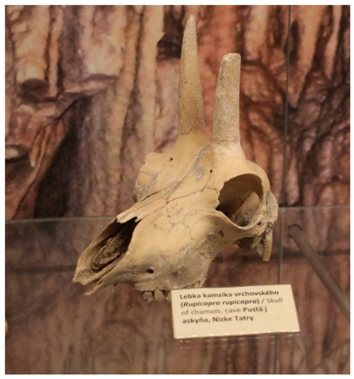
Figure 4.
Alpine chamois skull found in the Pustá Cave in the Ďumbier Tatras, deposited in the exposition of the Slovak Museum of Nature Protection and Speleology in L. Mikuláš (photo: P. Urban).
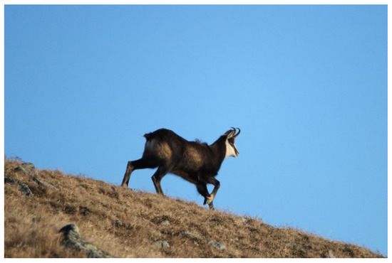
Figure 5.
Alpine chamois in its typical habitat in the Krúpova hol’a Mts. (photo: P. Urban).
During the Atlantic Climatic Optimum, the current flora and fauna of Central Europe were formed. From the perspective of historical periodization, the period of the Iron Age took place in the Subatlantic (from 800 years BC to recent years). In this period, the average annual temperature dropped to around 9 °C and the total annual precipitation stabilized at the current value of around 800 mm. Thus, the climate gradually took on today’s character. At that time, the vegetation comprised various species and covered the areas it would have comprised and covered at present if it were not for extensive human interventions. The upper limit of the forest reached its maximum height.
The chamois gradually migrated to the narrowest peaks of the Western Carpathians as a result of these natural climate changes. The natural upper limit of the forest shifted up to 300 m higher than it is currently. This greatly reduced the area of non-forested low-alpine enclaves, which decreased below the chamois existential minimum and led to their extinction.
From the perspective of research into original (natural) chamois alpine habitats in the Ďumbier Tatras, it is necessary to reconstruct the original mountain peak vegetation that grew here before intensive economic exploitation by man. The largest areas were covered by large primeval forests of beech (Fagus sylvatica), which rose to a height of 900 m a. s. l. or even higher. The mixed beech-fir primeval forests and the primeval forests dominated by the white fir (Abies alba) spread out to 1100 m a. s. l. The highest parts were covered with coniferous forests consisting mostly of white fir widely joined by spruce (Picea abies) in the upper forest limit. However, pure spruce forests were rare. Coniferous primeval forests reached the upper limit of the forest at an altitude of about 1800 m a. s. l. The highest parts of the Low Tatras ridge were covered by subalpine scrubland communities, and in the highest parts of the Ďumbier (2043 m a. s. l.), Chopok massifs represented the zone of alpine meadows.
At that time, the areas of naturally created meadows in the alpine zone, which were originally an important part of the chamois ecological habitat, were almost insufficient for the survival of the chamois population. The original colonisation of land by alpine meadows (non-forest formations) in the highest parts of the Ďumbier Tatras mountain range stabilized at its minimal coverage area at the turn of the era given. The natural alpine meadows occupied an area of only 941.66 ha in the highest parts of the Ďumbier and Chopok massifs, cliff reliefs included (Figure 6). This acreage had remained unchanged and thus unsuitable for the life of the chamois until the 15th century when extensive anthropogenic deforestation of the alpine territory began. This process, which lasted for several centuries, has been documented in written historical sources.
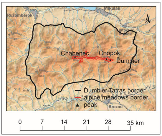
Figure 6.
The area of natural alpine meadows in the Ďumbier Tatras was only 941.66 ha. Source: National Atlas of Slovak Republic, 2002 (Map: Potential natural vegetation).
4.2. Documented Development of Ďumbier Tatras Alpine Vegetation
The previously unpublished conclusions presented in this section were based on archival research of documents stored in the Slovak Mining Archive in Banská Štiavnica, mainly in the Main Chamber-County Office fund. The documents and maps analysed in Section 4.2. have also been used in the research of historical mining and historical toponyms in the Low Tatras [61,62,63,64,65]. The content of these archival sources has also been used in the reconstruction of anthropogenic influences on the development of the landscape in the studied mountain range. This issue, as mentioned earlier, has not yet been treated and published in any relevant scientific article. The first written mention of the western part of the Ďumbier Low Tatras that discusses its mountain forest cover was available as early as 1263. It is listed in a deed from 5 April 1263 by King Belo IV., which not only grants L’upča (villam Lypche), Liptov (de lyptou), currently Partizánska L’upča, town privileges with several advantages, it also delimits the boundary of its region. The main landscape elements that form the boundary of the town area are precisely geographically defined and named. From the perspective of the studied topic, it is important to describe the southern border, which led to L’upčianska Valley, where it ascended to the peaks of the mountains (… sursum usque ad alpes …). Based on a precise geographical description of the border line, it is clear that the term “alpes” stated below denoted today’s Ďumbier Tatras. It is not clear from the context whether it was the name of a whole mountain range or just a term meaning mountains in general. Based on medieval clerical practices, we can assume that it meant mountains in general, as pointed out by the original meaning of the Celtic word alpes, which was understood to mean high mountains. In this sense, the term was also used in medieval Latin, and mountain ranges named this way were often rocky and partly deforested high mountains, ridges, peaks or hills. It is clear that until the 16th century, there were only natural bald mountains in the highest parts of mountain ranges. However, even the high mountain ranges with bald mountains described in the 17th century were already created by man. It was man-made bald mountains that became the main feature of the modern times Western Carpathians. Matej Bel also referred to the same meaning of this word when describing the mountain in his work Notitia in the first half of the 18th century. There, he speaks of a “mountain range” or “hill”, more precisely high man-made bald mountains, as alpes. The same designation was used by Samuel Mikovíni in his maps (Zvolen County, Turiec County, Liptov County). These names were then used in different language mutations until the 19th century.
The 1380 deed that for the first time directly proves the existence of natural alpine meadows in the Ďumbier Tatras has an irreplaceable historical value in connection with the natural afforestation of the Ďumbier Tatras mountain ridge top. On 14 August 1380, King Louis I of Hungary proclaimed an older mining settlement Brezno a free town and, at the same time, gave this town a large area of land. These privileges and delimitation of the border were reaffirmed by the same monarch on 31 August 1381. These deeds were not preserved but we know of them from their oldest known extracts dating back to 1494. The deed described a part of the northern boundaries of the newly formed town area that led to the ridge of the mountain (et per ipsum fluuium transit ad alpes) known as Hÿdeghawas.
It is the mentioned term Hÿdeghawas, identifiable with Ďumbier, that is most important in research on the natural deforestation on the top of the mountain. If we were to consider translating this “Hungarian word”, we would talk about a snowy (or cold) bald mountain. This explanation is quite probable because the peak of Ďumbier was originally one of the few in the Low Tatras that were naturally deforested and snow remained on their peaks until the summer months. It is noticeable that the white cover contrasting the surrounding green forests and scrub was surely a very distinctive or even mystical landmark for medieval man. At present, the entire mountain ridge of the Low Tatras is deforested and so those otherwise snow-capped peaks do not appear so remarkable in the landscape in late spring or early summer.
The first written mention, which already points to the existence of natural alpine meadows in the highest parts of the Ďumbier massif, is a mining permit in a 1570 mining book, according to which Ján Klain was permitted to open a new mine on the silver vein called St. Clement in a location known as Ďumbier Bald Mountain (Dumbirowa hola). Unter der Dumbirowa hola auf der abendt […] begent Hans Klain ein neue fundgrube aines silber gangs unnd nent die bey Sanct Clement (Figure 7).
Figure 7.
Ďumbier mountain ridge (2045 m a. s. l.), the highest peak of the Ďumbier Tatras (photo by: P. Urban).
From the 15th century, but especially in the 16th and 17th centuries, Vlach (shepherd) colonization began to contribute to the anthropogenic landscape development of the Ďumbier Tatras. Vlachs, who were gradually settling in the Horehronie region, became a serious and irreversible transformation factor for the landscape of the Ďumbier Tatras. The Vlachs grazed their flocks of sheep and goats in the forests, thus intensely damaging them. They began to create and enlarge pastures (balds) on the top of the mountain ridges extending from the main ridge of the Ďumbier Tatras, the main ridge included. Pasturing caused the upper parts of the original primeval forests to move down by around 200 m or more.
The first specific mention of shepherd presence in the Ďumbier Tatras dates back to 1466. The negative impact of shepherds on the mountain vegetation of the Ďumbier Tatras is subject to an important 1470 document by which the owner of L’upča Castle Ján Ernst granted Ladislav Valach (Ladislai Valachi) and his heirs the right to settle in the village Štiavnička (in possessione Schebnicza). Among other rights and privileges, the deed specifically emphasized that Ladislav Valach could feed and graze his herds in the mountains, forests and groves, as well as elsewhere in the village territory. As for the location of the Štiavnička medieval village (currently defunct settlement), it should be noted that it was situated in the central part of the Ďumbier Tatras, right at the southern foot of the Ďumbier massif.
From the 16th century, based on preserved historical documents, we can talk about the anthropogenically deforested ridge of the Ďumbier Tatras and artificially created balds. At the end of the 16th century, the area of deforestation was almost as extensive as we know it today, which has remained the same from the period after the end of cattle grazing on the top of the mountain range in the late 1980s.
From the first half of the 16th century, several partial names indicating the Ďumbier Tatras main ridge appeared in historical writings. These names were derived from the term hol’a (bald) or hole (balds), suggesting that there minimum trees covered the mountains. However, historical and geographical research has shown that this is no longer the general name of the mountain range (based on medieval Latin), but that the mentioned toponyms of the word hol’a (in different language forms) clearly refer to the anthropogenically created alpine pastures.
The anthropogenic bald mountains are also mentioned in a 1563 deed that redefined the borders of the Brezno town along the Ďumbier Tatras mountain ridge. An important finding arising from an analysis of the deed is that the writer already clearly distinguishes bald mountains/balds (Alpes) and mountain tops (montes).
Another important document containing several toponyms from the Ďumbier Tatras that pointed to the state of vegetation at the beginning of modern times is a record written by the Royal Commission in 1563 for Maximilian’s Forest Laws.
The most interesting point is the term used for the Ďumbier Tatras main ridge. For its designation, despite detailed knowledge, the writer did not use a specific (single) name but rather described it with several general Slovak-sounding terms, such as hole (in plural) or hol’a (in singular), which are mentioned in several places in the text. This term can be found in the description of the Lomnistá Valley (Holla) (Figure 8), Jasenianska Valley (Holla), Rástocká Valley (Holla), and Bukovská Valley (Holla) located in the easternmost part of the Ďumbier Tatras.
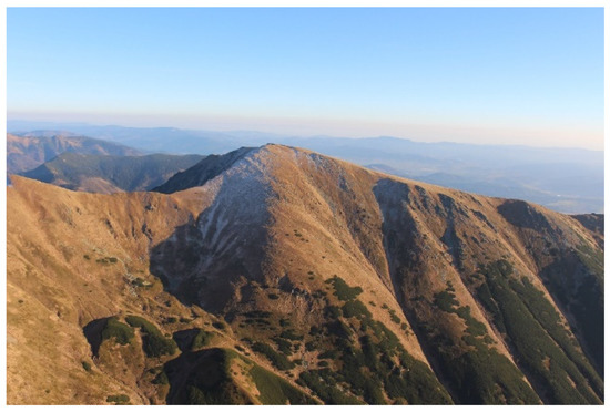
Figure 8.
Anthropogenically created habitats at the end of Lomnistá Valley, where the first High Tatras chamois were released in the early 1970s (photo by P. Urban).
Based on detailed records listing locations from east to west, we can assume that the Ďumbier Tatras were perceived by the local people separately as balds already created and intensively used by humans as grazing land. Individual bald mountains were divided by the valleys to which they naturally descended.
Several 16th-century documents related to the area of the Ďumbier Tatras and dealing with contemporary mining have been preserved. These sources present toponyms in connection with the location of mines, galleries, shafts or metallurgical facilities that clearly point to the extensive anthropogenic deforestation of the mountain tops. Only partial designations of the deforested ridge or its highest parts stating the term hole in different language forms are mentioned in the documents. For example, in 1551 the term Bukovská hol’a (Bukovitz Holla), and in 1552, the term a bald (hol’a) for the (Vel’ký) Gápel’ (Gapll Hole) were used. In Mining Court records in Vyšná Boca dating back to 1559, the bald mountains (Holla) over Kunštova Valley (Khunstgrunt) are mentioned.
At the end of the 17th century, the new name of the Ďumbier Tatras as a whole mountain range appears, resulting from their anthropogenic appearance. In 1681, the first detailed depiction of the Ďumbier Tatras is presented in a handwritten map called Most Recent Description of Upper Hungary (Hungariae superioris novissima descriptio). Here, the word form Hole was used for the first time to designate the Low Tatras. The Ďumbier Tatras is called Montes Holle, which can be translated as “Bald Mountain Range”.
In his work Notitias of Zvolen County, published in 1736, Matej Bel also called the Ďumbier Tatras, bald mountains (hole). Due to their location in the Zvolen County, Bel called them “Bald mountains (Hole) in the North (Alpes septentrionales)” or, more precisely, “Bald mountains (Hole) dominating the territory in the North (Alpes septentrioni Obiectae)”. The Zvolen County was well known to him, not just because he was born there, but also due to his engagements in Banská Bystrica and many trips he organised in this region. So as a very good connoisseur of the county, Bel points out that Slovaks use the name Hole for deforested and dry peaks and Hungarians used the name Havasok because of the snow staying on mountain tops. About the main deforested peak, he wrote: “Balds are not just inhospitable peaks. There are places on less steep hills that overflow with pastures which are predestined to be a place for the reproduction and feeding of grazing herds. As the grass that grows here at the end of spring when its turning into summer…”.
In the second half of the 19th century, grazing balds as the main feature of the mountain were no longer important for the naming of the whole mountain range. This was probably because the bald mountains have adapted to the landscape and become its main feature, and are more or less understood as its natural component. At the end of the 19th century, in addition to alpine pastoralism, a new phenomenon, tourism, became part of the Ďumbier Tatras landscape management.
Tourism, as it is understood today, began to develop in the Ďumbier Tatras quite late, i.e., in the late 19th and early 20th centuries. In the second half of the 19th century, tourists used to visit the Ďumbier Tatras only sporadically and usually stayed for longer.
No sooner than the end of the 19th century, the Hungarian Carpathian Association was established. Even though its activities were focused on tourism, climbing and skiing, its most important goal was to discover and make mountains accessible to the public. On the northern side, the Liptov Department based in Liptovský Mikuláš and founded in 1884, was in charge of the Low Tatras, and on the southern side, the Tatras were administered by the Zvolen Department based in Banská Bystrica and established in 1889. It took the Zvolen Department four years to build a serpentine trail from Trangoška to Ďumbier (1991–1899), which was subsequently repaired several times and marked in 1908. In 1902, members of the department built a brick house on the ridge just below Ďumbier. It was the first alpine house of this type in the Low Tatras. It was opened on 24 August 1902, but just to be completely run-down and abandoned shortly after during World War I.
After the establishment of Czechoslovakia in 1918, other associations began to form, and they intensified the development of tourism in the Ďumbier Tatras, which was also closely related to an increased interest in skiing. Skiing began to boom here in the early 20th century.
New caves discovered on the northern and southern sides of the mountain range in the 1930s became a new impulse for tourism development (Demänovské Caves in 1921, Bystrianska Cave in 1923, and the caves in Kozie chrbty Mts. below Ďumbier in 1925).
Another boom wave was triggered by transport development. In 1932, a regular bus connection was introduced from Podbrezová to Mýto pod Ďumbierom. In 1934, the road to Trangoška Cottage and, later, to the Srdiečko Hotel was finished. In 1936, the railway line Červená skala–Margecany was opened. It connected the central (Zvolen–Banská Bystrica–Brezno–Telgárt) and the eastern (Košice–Bohumín railway) part of Slovakia. In the 1940s, other mountain cabins were built, on the Chabenec massif in 1932 and under the Vel’ký bok pasture and on Trangoška in 1936. It was possible to cross the whole mountain range in five days.
After World War II, massive tourism development gradually affected the Ďumbier Tatras. This led not only to infrastructure development and the maintenance of the landscape, making it more attractive to tourists, but also to intensive nature protection. The area became part of the newly established Low Tatras National Park in 1978 (Figure 9 and Figure 10).
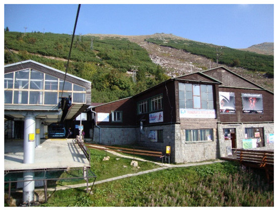
Figure 9.
Tourism superstructure on the southern slope of the Chopok massif (2023 m a. s. l.), dividing the chamois habitat into two parts (photo B. Gregorová).
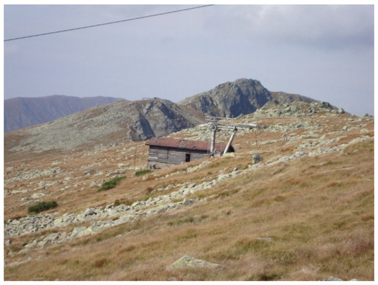
Figure 10.
Habitat in the top part of Chopok massif, divided by the linear tourism superstructure (photo B. Gregorová).
4.3. Current State of Forest Upper Limit and Expansion of Man-Made Mountain Meadows-Balds
All these historical anthropogenic activities led to the creation, or restoration, of grassy habitats of such quality and extent that at the beginning of the 20th century, conditions were created for the managed relocation of the chamois to the Ďumbier Tatras. The balds representing such grassy habitats have become the basic landscape resource for creating a chamois habitat.
The maximum expansion of the man-made grassy alpine stands in the Ďumbier Tatras can be seen on maps from the second stage military mapping (1880s) (available on the Internet https://mapire.eu/en/ (accessed on 24 July 2022)) as one of the sources of previous historical and geographical analysis. This expansion is confirmed by “modern” aerial photographs from the mid-20th century (archive of the Department of Geography and Geology, Matej Bel University, Banská Bystrica, Slovakia), which show that the stand covered an area of more than 6600 ha. This habitat area already provided a sufficient ecological environment for the life of an independent chamois population in the Ďumbier Tatras. Thanks to these suitable conditions, chamois introduction was already considered as early as the turn of the 19th and 20th centuries. During this period, the artificial upper limit of the forest in the Ďumbier Tatras oscillated between 1300 and 1520 m a. s. l. [66].
The period of grazing boom that took almost five centuries ended in the second half of the 20th century (1960–1970s) when there was a gradual decline in sheep and cattle grazing on alpine pastures. After 1989, there was literally no grazing left on the national park pastures. For this reason, the succession at the upper forest boundary caused the gradual shift of the anthropogenic upper forest boundary to the higher mountain altitudes [67]. In addition, to the end of grazing and the natural course of succession, climate change also began to influence the development of land cover and thus significantly contributed to the upper forest boundary shift to higher altitudes. In 2018, the area of deforested peaks—bald mountains that represent the chamois potential habitat—was 6665.61 ha (CORINE Land Cover, Copernicus, 2018) (Figure 11).
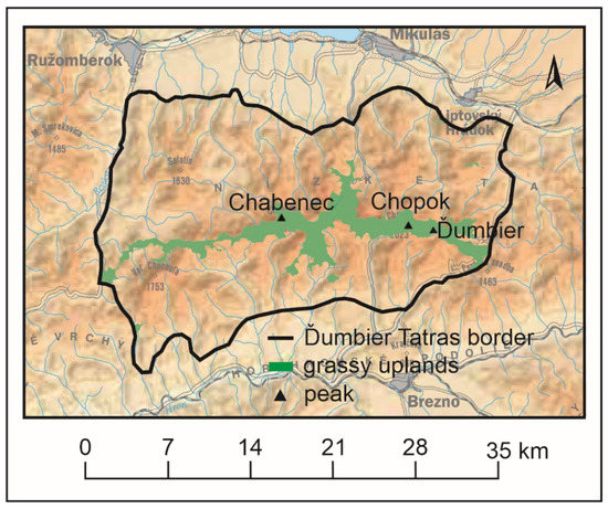
Figure 11.
The current area of anthropogenically formed balds in the Ďumbier Tatras mountain is 6665.61 ha, which showcases the potential habitat of the Alpine chamois. Source: CORINE Land Cover (Copernicus, 2018) and National Atlas of Slovak Republic, 2002.
The gradual overgrowing of current habitats will require new trends in the management and protection of the national park mountain landscape where modern tourism can be an important tool in this process (Figure 12).
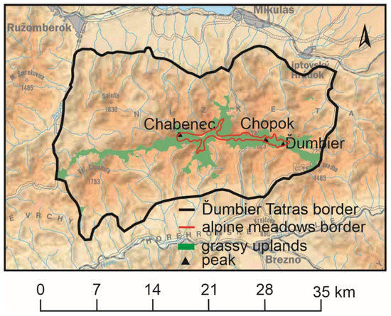
Figure 12.
Comparison of the expansion of natural alpine meadows at the turn of the century, when the chamois completely disappeared from the landscape of the Ďumbier Tatras, with the current area of balds created by anthropogenic activities. (Compiled based on: [47]; CORINE Land Cover (Copernicus, 2018).
Tourism can be of significant benefit to protected areas if, in terms of day-to-day management, the requirements for ensuring unique tourist experiences are aligned with nature conservation. In this sense, it is necessary to adopt management measures that will have an ecosystemic and adaptive character leading to the regulation of tourist traffic and the promotion of sustainable tourism in terms of new forms of tourism such as geotourism, nature tourism, ecotourism, adventure tourism, rural tourism, etc. [68].
5. Discussion
5.1. Chamois Habitat in the Ďumbier Tatras in Anthropogenically Created Alpine and Subalpine Environments
Once the anthropogenic chamois habitat was created and suitable conditions were stabilised in the high mountain part of the Ďumbier Tatras, the reintroduction of this species to the mountain range was considered. Probably the first known activities date back to 1900 when the owner of Štrbské Pleso, Jozef Szentivány, introduced four chamois to the Krčahovo Valley. However, the reintroduction was unsuccessful (all four chamois died), and so was the 1935 attempt to reintroduce the chamois to the Orlovo Valley in the part of the mountain range called Král’ova Hol’a. Further efforts were made after World War II in connection with the negative chamois population trend shown in the Western, High and Belianske Tatras where, in the meantime, the Tatra National Park was established (in 1948, effective as of 1 January 1949).
In connection with the decrease in the number of chamois and tourism development in this national park, there were concerns about possible contagious disease outbreaks (e.g., scabies or blindness) that could decimate the chamois population. The idea of establishing a population of substitutes for the original Tatra chamois in a suitable Slovak location became reality.
In 1968, after a rapid decrease in the number of chamois in the Tatra National Park, Ing. Blahout elaborated a proposal for chamois introduction to other Slovak mountains. Of the three proposed mountains (Low Tatras, Greater and Lesser Fatra), the central part of the Low Tatras was concluded to be the most appropriate. The analysis was based on the fact that, in order to implement these activities, a year’s worth of suitable and quality habitats for the species (taxon), in which it could maintain a viable population in the long term, had to be ensured. Moreover, he prepared the methodology for trapping the chamois in the Tatra National Park and proposed suitable locations for their release, which were at the southern side of the central part of the Low Tatras or the end of the Lomnistá Valley.
During the following eight years (1969–1976), 30 chamois (11 males, 16 females and three calves) were relocated from the Tatra National Park to the Low Tatras, with 20 chamois (66.7%) released in the first three years of reintroduction (1968–1970) and the remaining 10 chamois (33.3%) released between 1972 and 1976. Two chamois died and therefore did not contribute to the strengthening of the newly established population.
Between 1969 and 1980, the population showed a balanced upward trend without any significant fluctuations. In 1980, 121 chamois formed the population. In the following years, this number varied in the range of 100–120 chamois. During the 1986 to 1995 period, it stabilized on an estimated number of 120–140 chamois. From 1996, the population began to decrease and since the end of the 1990s, the number has stabilized at around 100 chamois (Figure 13). The number of chamois in the given population, just like in other chamois locations in the Tatras, is influenced by intraspecific and interspecific relationships, predators, parasites, diseases, food availability and quality, and climatic conditions at the time of the birth or immediately after it, as well as by increasing tourism and human leisure activities in the area. Effective population sizes are relatively small and may maintain genetic diversity and adaptability limited over the long-term.
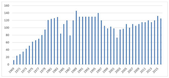
Figure 13.
Number of chamois in Low Tatras between 1969 and 2015.
Despite the successful reintroduction of the Tatra chamois to the Low Tatras, the introgression of the alpine genome into the gene pool of this population can theoretically lead to a loss of unique genetic composition [69].
5.2. Anthropogenic Mountain Landscape—As the Ex-Habitat of Alpine Chamois and Its Current State
The reintroduction was successful and a suitable environment was created (deforested peak region of the mountains reaching an area of more than 6000 ha) even though the chamois in the Ďumbier Tatras has had a relatively limited space of only 400–450 ha. The above area covers the central part of the mountain range above the upper edge of the forest. The Tatra chamois, unlike the Alpine chamois, only rarely descend to the supramontane vegetation level and permanently inhabits mostly the subnival, alpine and subalpine vegetation levels in the rugged relief of glaciers and balds. The specific geomorphological character of the core region of the chamois habitat in the Ďumbier Tatras in relation to its peripheral regions, which are approximately 200–300 m lower than the Chabenec–Štiavnica ridge parts, was already highlighted by Radúch and Karč [70]. (Figure 14 and Figure 15).
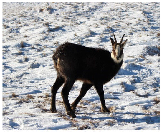
Figure 14.
Alpine chamois in its natural environment in the Ďumbier Tatras (photo P. Urban).
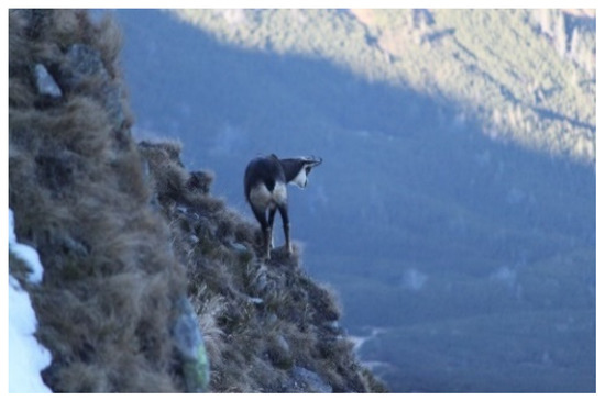
Figure 15.
Alpine chamois in its natural environment in the Ďumbier Tatras (photo P. Urban).
The size of the area has fluctuated over the years, with no significant differences. In the middle of the reintroduction, the chamois area was 9 km long and 5 km wide, with the centre located in the Skalka area (the site where the chamois were released). Shortly after the end of the reintroduction (1977–1980), the area of the Tatra chamois in the Ďumbier Tatras was almost identical to its current area. It took an area of 2626 ha, from the Ďurková saddle (1751 m) in the west to the end of the Štiavnica Valley near the mountain cabin under Ďumbier in the east, or from Žiarska hol’a (1840 m) in the south to Mošnica Valley (Bôrov north depression) in the north. Between 1982 and 1985, the size of the chamois area in the Ďumbier Tatras was planimetrically determined to be 2827 ha, of which the winter habitats occupied only 1301 ha [71].
At present, the chamois habitat forms part of the main ridge of the Ďumbier Tatras, approximately from Chabenec (1955 m) or Ďurková (1749.8 m) in the west to the massif of Štiavnica (2025.3 m) or Králičky (1807.4 m) in the east (which is almost 20 kilometres long), and to its lateral north forks (Pol’ana–Zákl’uky–Bôr or Ludárova hol’a) and southern forks (Kotliská–Skalka–Žiarska hol’a, or Kozie chrbty) with adjacent upper limits of the valleys (Lomnistá, Vajskovská, Krížska, Demänovská, Široká, Ludárova, Jánska), mainly in the subalpine and alpine vegetation levels.
5.3. Negative Impact of Tourism on the Distribution of the Alpine Chamois and Its Habitat
However, the centre of the chamois area is divided by passenger mountain transport facilities and the Jasná resort (north and south) ski slopes, which were established in the middle of the last century and have been significantly expanded since 2010.
The establishment of the Jasná resort was also preceded by other recreational activities that influenced the alpine landscape during the 20th century and negatively impacted the distribution of the Alpine chamois. These were mainly the marking of hiking trails and the construction of mountain cabins that promoted tourism development and intensified visits to the exposed parts of the ridge of the Ďumbier Tatras.
The first association that organized tourism in the Low Tatras was the Hungarian Carpathian Association. The association built two mountain cabins (the 1885 log cabin near Demänovská Cave, and the 1902 Karolova Chata stone cabin at Ďumbier). Moreover, they marked hiking trails (from the Demänovská Valley to Ďumbier, the trail to Poludnica, Železné and Lúčky, and the Demänovská Ice Cave), organized excursions, and provided guide services, together with information about terrain and accommodation options, to foreign visitors and members of the association from Germany and Hungary [72].
After the establishment of Czechoslovakia in 1918, other hiking associations began to be formed, which further intensified the number of hikers. The most important was the Club of Czechoslovak Tourists, which was founded in 1920.
The popularity of skiing is also closely related to intensified hiking activities. However, the conditions for skiing began to develop as late as the beginning of the 20th century, and even then, it was on a very small scale. In 1907, the first skiers (Oskar Jordán and companions) ascended the south side of Ďumbier, from where they continued to Krupova hol’a and Chopok. At that time, the Karolova Chata cabin was still located at Ďumbier. Before that, however, it was not possible to ascend the tops of the Low Tatras ridge in winter [73].
Since 1920, under the auspices of the Ministry of Interior of the Czechoslovak Republic, hiking trails were professionally marked by the Czechoslovak Tourist Club in individual mountain ranges. The goal was to increase the attendance of the ranges and “bring them closer” to the wider public. Since then, due to an increase in negative effects, the local landscape was deliberately transformed into recreational areas and the habitat of the Alpine chamois began to shrink. In addition, mountain holiday cabins began to be built in the area of the main ridge. The first of these was the General M. R. Štefánik Cabin under Ďumbier, the construction of which began in 1924 and, after many problems, was finally put into use in 1928 [72].
In the 1930s, other hiking cabins were built: in 1932 at the Chabenec massif, in 1936 under the Vel’ký Bok pasture and at the Trangoška peak, and then under the Král’ova hol’a peak and at the Smrečiny peak. Thus, it was finally possible to pass the entire mountain range in five days.
After World War II, the construction of recreational infrastructure intensified even more. At the foothill of Chopok, a recreational resort called Srdiečko was formed. The resort also became a starting point for ascents to Chopok. At the same time, a cable car to Chopok began to be built. Its existence laid the foundation for a large recreational area (now known as Jasná a.s.), which divided the initially unified habitat of the chamois into the western and eastern regions. The mountain cabin under the Ďumbier peak, later known as the SNP Heroes Cabin, was completed and extended. At the top of Chopok, a cabin called “Kamenná chata” was built, and at the divide station under Chopok, a mountain hotel was also ready to be put into use.
In 1954, a mountain chair lift to Chopok from the Liptov side was completed, and on the southern side, the first section leading to the divide station was put into operation. There, a mountain cabin called Kosodrevina was already in use. By 1955, several original recreational facilities on the ridge were repaired, cabins on Trangoška were opened, and in emergency cases, the cabins on Chabenec, Čertovica, and under Ďumbier could be used [74].
In 1961, the concept of tourism development in the Low Tatras region was designed. It took the form of a spatial plan of the district, which was to regulate the construction of recreational facilities in the entire area. Since the summer of 1970, the old ski slopes were being modernised and new ski slopes on Chopok, namely Kosodrevina–Srdiečko, Srdiečko–Krupová, Chopok–Krupová, Dereše–Kosodrevina, were being built. The uncontrolled increase in the attendance of the exposed sites negatively impacted the recreational value and the natural environment the territory used to have. The Urbion—State Institute of Urban and Spatial Planning was therefore asked to create a “spatial planning documentation of the Low Tatras territorial unit” in which other possibilities for its development would be outlined according to nature protection principles (the heart of this area, which had a primarily recreational function, was also a national park). The size of the area suitable for recreation was set to be 318,000 ha, of which 76,300 ha was to be used for recreational purposes. With an estimated attendance of 90,000 tourists per day by 2000 (44,000 outings and 46,000 domestic and foreign stays), it was proposed to further construct accommodation, catering and sports recreational capacities in the selected recreational areas. As Chopok was proving to be the busiest area of the whole territory, a special study called “Chopok—South Low Tatras Centre of Recreation and Tourism” was prepared to support its use. In the study, the main premises of the resort were considered to be Srdiečko, Trangoška and Krúpova dolina. On the other hand, Kosodrevina, Dereše, Chopok, and the “Heroes of the SNP” cabin, were perceived as distant areas interconnected with hiking trails and transport facilities [75].
In 1989, there was a radical transformation of political, economic and social conditions, which led to the privatization of infrastructure and superstructure, changing clientele, increased demands on the quality of services, the inability of many enterprises to adapt to current trends and their subsequent disappearance. This change resulted in uneven and unbalanced development of the Low Tatras; some areas of recreational value became even more burdened (Chopok, Ďumbier); others, on the other hand, lost their status (Krpáčovo).
At present (30 June 2022), there is one funicular, four gondola lifts and eight chair lifts, as well as 11 other ski lifts, which together can transport almost 30,000 visitors per hour. More than 50 km of the ski slopes and ski routes built from the main ridge to its foothills have a major impact on the original landscape and the chamois territory. In addition, the ridge of the mountain range, side crossroads and valleys included, has a network of hiking trails that equal the total length of more than 150 km (according to field research) (Figure 16).
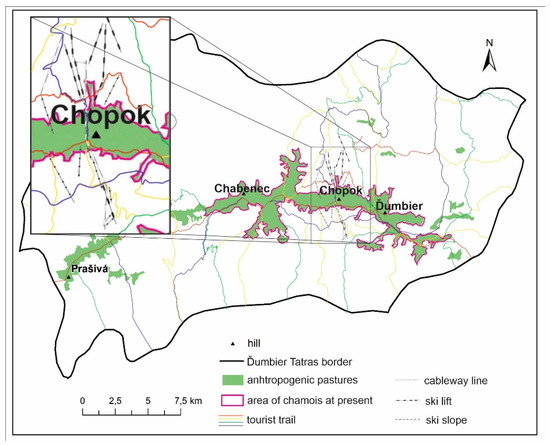
Figure 16.
Area of chamois colonization in the Ďumbier Tatras in relation to recreational infrastructure and superstructure (Source: authors’ research, National Atlas of Slovak Republic, 2002).
5.4. Comparison of Changes in the Habitat Areas of the Alpine Chamois in the Ďumbier Tatras
At the turn of the century, the Western Carpathians mountain climate settled, and the vegetation cover attracted various species and led to the distribution of the landscape that it might have today if it were not for human intervention. The area of alpine meadows of almost 1000 ha also stabilized. At the same time, the original chamois population of the Ďumbier Tatras became extinct. From the 15th century, Wallachian Colonization (intensive alpine grazing of sheep and goats) began to shape the landscape, which in a relatively short time (around a century) caused the deforestation of the upper part of the mountain range and the emergence of anthropogenic pastures on an area of more than 6600 ha. Since this period, suitable conditions for the life of the chamois in the Ďumbier Tatras have been identified.
The reintroduction of the Alpine chamois in the Ďumbier Tatras at the turn of the 1970s and 1980s was mostly focused on the highest part of the mountain range covering 2827 ha, as this was considered to be the most suitable habitat for the development of the population (Figure 17). In winter, this area is usually reduced to only 1301 ha [71].
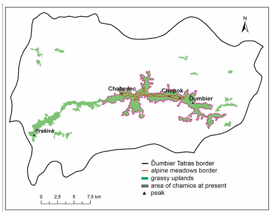
Figure 17.
Comparison of the original alpine meadows and anthropogenically formed uplands with the current area of distribution of the Alpine chamois (Source: authors’ research, National Atlas of Slovak Republic, 2002).
6. Conclusions
Based on the historical and geographical analysis of sources related to the anthropogenic transformations of the landscape of the Ďumbier Tatras from the very beginning of its use, we can conclude that the peak region of the mountain range had the features of not only a transformed but also a partly devastated (alpine) landscape as early as the second half of the 16th century [76]. Mining was spreading from below against the direction of mountain streams, and shepherds (Wallachians) were deforesting the mountain range at its peaks. It was mostly the activity of the Wallachians that led to a significant expansion of natural alpine meadows and the creation of anthropogenic alpine pasture balds. Balds were also formed in the places where scrubs and forests grew in the upper parts of the mountain range. The extensive erosion of the soil cover of the balds occurred due to excessive grazing [77,78]. Anthropogenically formed mountain landscapes and bald mountain ranges have dramatically transformed the original, natural character of the forested mountain range into a deforested landscape.
Paradoxically, the anthropogenically created balds, as the main relic of the medieval landscape, significantly contributed to the fact that in the upper part of the Ďumbier Tatras, suitable conditions were created for the reintroduction of the Alpine chamois, which was successfully achieved by conservationists in the second half of the 20th century. At present, the population is relatively stable, and due to its abundance, has an adequate habitat. In the last two decades, however, the biggest enemy of the chamois in the Ďumbier Tatras has been ever-expanding tourism [72].
The development of modern recreational infrastructure and the growing number of visitors in the exposed areas of the mountain range, which forms the central habitat of the chamois population in the peak regions, has negatively impacted its living space. The habitat, which was initially homogeneous, was later divided into the western and eastern regions as a result of the construction of recreational facilities in the Chopok area. In the future, the maintenance of a prosperous population of Alpine chamois in the Ďumbier Tatras will require well-targeted landscape protection within the Low Tatras National Park and the active management of the alpine landscape by conservationists, which will provide a good precondition for the sustainability of this population.
Author Contributions
Conceptualization, P.H., P.U., B.G. and V.Č.; general analysis, P.U.; historical analysis, P.H. and B.G.; investigation, P.H., P.U., B.G. and V.Č.; resources and data curation, P.H., P.U., B.G., V.Č. and D.T.; writing-original draft preparation, P.H., P.U., V.Č. and D.T.; writing—review and editing, B.G. and D.T.; visualization, P.H., B.G. and P.U.; supervision, B.G.; project administration, V.Č. and D.T.; funding acquisition, B.G. All authors have read and agreed to the published version of the manuscript.
Funding
This research was funded by Land-Use Changes of Slovak Cultural Landscape and Prediction of its Further Development, grant number APVV-18-0185 and KEGA Agency, grant number 045PU-4/2022.
Conflicts of Interest
The authors declare no conflict of interest.
References
- Martínková, N.; Zemanová, B.; Kranz, A.; Giménez, M.D.; Hájková, P. Chamois introductions to Central Europe and New Zealand. Folia Zool. 2012, 61, 239–245. [Google Scholar] [CrossRef]
- Apollonio, M.; Scandura, M.; Šprem, N. Reintroductions as a Management tool for European Ungulates. In Behaviour and Management of European Ungulates; Putman, R., Apollonio, M., Eds.; Whittles Publishing: Scotland, UK, 2014; pp. 46–77. [Google Scholar]
- IUCN; SSC. Guidelines for Reintroductions and Other Conservation Translocations; Version 1.0; IUCN Species Survival Commission: Gland, Switzerland, 2013; Volume viiii, 57p. [Google Scholar]
- Berger-Tal, O.; Blumstein, D.T.; Swaisgood, R.R. Conservation translocations: A review of commondifficulties and promising directions. Anim. Conserv. 2020, 23, 121–131. [Google Scholar] [CrossRef]
- Crestanello, B.; Pecchioli, E.; Vernesi, C.; Mona, S.; Martínková, N.; Janiga, M.; Hauffe, H.C.; Bertorelle, G. The genetic impact of translocations and habitat fragmentation in chamois (Rupicapra) spp. J. Hered. 2009, 100, 691–708. [Google Scholar] [CrossRef] [PubMed]
- Sprem, N.; Buzan, E. The Genetic Impact of Chamois Management in the Dinarides. J. Wildl. Manag. 2016, 80, 783–793. [Google Scholar] [CrossRef]
- Rezić, A.; Safner, T.; Iacolina, L.; Bužan, E.; Šprem, N. Traces of past reintroduction in genetic diversity: The case of the Balkan chamois (Mammalia, Artiodactyla). ZooKeys 2022, 1116, 57–70. [Google Scholar] [CrossRef]
- Corlatti, L.; Lorenzini, R.; Lovari, S. The conservation of the chamois Rupicapra spp. Mammal Rev. 2011, 41, 163–174. [Google Scholar] [CrossRef]
- Christie, A.H.C. A note on the chamois in New Zealand. Proceedings 1964, 11, 32–36. Available online: http://www.jstor.org/stable/24061467 (accessed on 1 September 2022).
- Buzan, V.E.; Bryja, J.; Zemanová, B.; Kryštufek, B. Population genetics of chamois in the contact zone between the Alps and the Dinaric Mountains: Uncovering the role of habitat fragmentation and past management. Conserv. Genet. 2013, 14, 401–412. [Google Scholar] [CrossRef]
- Bačkor, P. Bibliografia kamzíka vrchovského tatranského (Rupicpara rupicapra tatrica) v Nízkych Tatrách. Lynx Ns 2007, 38, 119–128. [Google Scholar]
- Bačkor, P.; Velič, E. Restitution Tatra chamois (Rupicapra rupicapra tatrica Blahout 1971) to the Nízke Tatry Mts (Central Slovakia). Nat. Conserv. 2008, 65, 17–25. [Google Scholar]
- Bačkor, P.; Urban, P. Kamzík vrchovský tatranský v Národnom parku Nízke Tatry. Folia Venatoria 2009, 38, 45–62. (In Slovak) [Google Scholar]
- Urban, P.; Malina, R. Reštitúcia kamzíka vrchovského tatranského (Rupicapra rupicapra tatrica) do Nízkych Tatier (stredné Slovensko). Quaest. Rerum Nat. 2017, 1, 51–134. [Google Scholar]
- Buchalová, Z.; Hurta, V.; Lešová, A. Vplyv turizmu na zmeny v etológii kamzíka vrchovského tatranského (Rupicapra rupicapra tatrica) v centrálnej časti Nízkych Tatier (Západné Karpaty). Ochr. Prírody 2021, 38, 73–80. [Google Scholar]
- Šprocha, J. Kamzíky vo Vel’kej Fatre, Slovenskom raji a v Nízkych Tatrách (Chamois distribution of the Vel’ká Fatra Mts., Slovenský raj Mts. and Nízke Tatry Mts.). Pol’ovníctvo Rybárstvo 1971, 23, 8–9. [Google Scholar]
- Šimo, J. Dvadsať rokov od introdukcie kamzíka alpského pôvodu v Gaderi (Introduction of Alpine chamois in the Gader twenty years ago). In Súčasný Stav a Perspektíva Introdukovaných Populácií Kamzíka Vrchovského na Slovensku. (Present Abundance and Perspective of Chamois in the Slovakia); Dom Techniky, ČSVTS: Banská Bystrica, Slovakia, 1981; pp. 98–105. (In Slovak) [Google Scholar]
- Corlatti, L.; Iacolina, L.; Safner, T.; Apollonio, M.; Buzan, E.; Ferretti, F.; Hammer, S.E.; Herrero, J.; Rossi, L.; Serrano, E.; et al. Past, present and future of chamois science. Wildl. Biol. 2022, e01025. [Google Scholar] [CrossRef]
- Arnal, M.; Fernandez-de-Luco, D.; Riba, L.; Maley, M.; Gilray, J.; Willoughby, K.; Vilcek, S.; Nettleton, P.F. A novel pestivirus associated with death in Pyrenean chamois (Rupicapra pyrenaica pyrenaica). J. Gen. Virol. 2004, 85, 3653–3657. [Google Scholar] [CrossRef] [PubMed]
- Corlatti, L.; Béthaz, S.; von Hardenberg, A.; Bassano, B.; Palme, R.; Lovari, S. Hormones, parasites and male mating tactics in Alpine chamois: Identifying the mechanisms of life history trade-offs. Anim. Behav. 2012, 84, 1061–1070. [Google Scholar] [CrossRef]
- Skonhoft, A.; Yoccoz, N.G.; Stenseth, N.C.; Gaillard, J.M.; Loison, A. Management of chamois (Rupicapra rupicapra) moving between a protected core area and a hunting area. Ecol. Appl. 2002, 12, 1199–1211. [Google Scholar] [CrossRef]
- Ferretti, F.; Costa, A.; Corazza, M.; Pietrocini, V.; Cesaretti, G.; Lovari, S. Males are faster foragers than females: Intersexual differences of foraging behaviour in the Apennine chamois. Behav. Ecol. Sociobiol. 2014, 68, 1335–1344. [Google Scholar] [CrossRef]
- Hamr, J. Disturbance Behaviour of Chamois in an Alpine Tourist Area of Austria. Mt. Res. Dev. 1988, 8, 65–73. [Google Scholar] [CrossRef]
- Brivio, F.; Bertolucci, C.; Tettamanti, F.; Filli, F.; Apollonio, M.; Grignolio, S. The weather dictates the rhythms: Alpine chamois activity is well adapted to ecological conditions. Behav. Ecol. Sociobiol. 2016, 70, 1291–1304. [Google Scholar] [CrossRef]
- Chirichella, R.; Ciuti, S.; Apollonio, M. Effects of livestock and non-native mouflon on use of high-elevation pastures by Alpine chamois. Mamm. Biol. 2013, 78, 344–350. [Google Scholar] [CrossRef]
- Lovari, S.; Ferretti, F.; Corazza, M.; Minder, I.; Troiani, N.; Ferrari, C.; Saddi, A. Unexpected consequences of reintroductions: Competition between reintroduced red deer and Apennine chamois. Anim. Conserv. 2014, 17, 354–370. [Google Scholar] [CrossRef]
- Yankov, Y.; Valchev, K.; Milushev, V.; Varlyakov, I. Raising the effectiveness and minimizing the risk in the capturing of chamois for resettlement. Trakia J. Sci. 2011, 9, 62–70. [Google Scholar]
- Fioravanti, T.; Splendiani, A.; Giovannotti, M.; Cerioni, P.N.; Righi, T.; Rossetti, A.; Morandi, F.; Barucchi, V.C. The chamois (Rupicapra cf. pyrenaica) in central Italy: What ancient DNA tells us. Hystrix 2019, 30, 186–190. [Google Scholar] [CrossRef]
- Formenti, N.; Viganó, R.; Fraquelli, C.; Trogu, T.; Bonfanti, M.; Lanfranchi, P.; Palme, R.; Ferrari, N. Increased hormonal stress response of Apennine chamois induced by interspecific interactions and anthropogenic disturbance. Eur. J. Wildl. Res. 2018, 64, 68. [Google Scholar] [CrossRef]
- Pedrotti, L.; Lovari, S. Rupicapra rupicapra. In The Atlas of European Mammals; Academic Press: London, UK, 1999; pp. 406–407. [Google Scholar]
- Shackleton, D.M. (Ed.) Wild Sheep and Goats and their Relatives: Status Survey and Conservation Action Plan for Caprinae; International Union for Conservation of Nature: Fontainebleau, France, 1997. [Google Scholar]
- Bjorn, K. Pleistocene Mammals of Europe; Weidenfeld & Nicholson: London, UK, 1968. [Google Scholar]
- Lovari, S. Systematics, phylogenetic relationships and dispersal of the chamois (Rupicapra spp.). Quat. Res. 1988, 30, 339–349. [Google Scholar]
- Blahout, M. Zur Taxonomie der Population von Rupicapra rupicapra (Linné, 1758) in der Hohen Tatra. Zool. Listy 1972, 21, 115–132. [Google Scholar]
- Hronček, P. Možnosti využitia interdisciplinárnych výskumných metód v histórii, pri výskume historickej krajiny a historických krajinných prvkov. Zborník Kysuc. Múzea 2014, 16, 21–64. [Google Scholar]
- Benčo, J. Metodológia Vedeckého Výskumu; IRIS: Bratislava, Slovakia, 2001; 194p. (In Slovak) [Google Scholar]
- Hendl, J.; Remr, J. Metody Výzkumu a Evaluace; Portál: Praha, Czech Republic, 2017; 372p. (In Czech) [Google Scholar]
- Ochrana, F. Metodologie, Metody a Metodika Vědeckého Výzkumu; Karolinum: Praha, Czech Republic, 2019; 148p. (In Czech) [Google Scholar]
- Gomez, B.; Jones, J.P. Research Methods in Geography: A Critical Introduction; Wiley-Blackwell: Chichester, England, 2010; 481p. [Google Scholar]
- Michaeli, E.; Ivanová, M. Geografická Tektológia—Metageografia; PU FHPV: Prešov, Slovakia, 2015; 252p. (In Slovak) [Google Scholar]
- Krištofičová, E. Prostriedky Hodnotenia Knižničných a Vedeckoinformačných Procesov; CVTI: Bratislava, Slovakia, 1997; 157p. (In Slovak) [Google Scholar]
- Carrizo-Sainero, G. Toward a Concept of Bibliometrics. J. Span. Res. Inf. Sci. 2000, 1, 59–86. [Google Scholar]
- Ondrišová, M. Bibliometria; Stimul: Bratislava, Slovakia, 2011; 134p. (In Slovak) [Google Scholar]
- Hronček, P.; Jakubík, J. Možnosti interpretácie vel’komierkových historických máp pri výskume miestnej krajiny. In Studie z Dějin Geodézie a Kartografie; Národní Technické Muzeum v Praze: Praha, Czech Republic, 2011; Volume 15, pp. 23–28. (In Czech) [Google Scholar]
- Boltižiar, M.; Olah, B. Potenciál historických máp a leteckých snímok pri štúdiu zmien krajiny. Geogr. Rev. 2008, 4, 64–82. [Google Scholar]
- Boltižiar, M.; Olah, B. Krajina a Jej Štruktúra (Mapovanie, Zmeny a Hodnotenie); UKF v Nitre, Fakulta Prírodných Vied: Nitra, Slovakia, 2009; 148p. (In Slovak) [Google Scholar]
- Maglocký, Š. Potenciálna prirodzená vegetácia 1:500 000. In Atlas krajiny SR; Ministerstvo Životného Prostredia SR: Bratislava, Slovakia, 2002; pp. 114–115. (In Slovak) [Google Scholar]
- Butlin, R.A.; Dodgshon, R.A. An Historical Geography of Europe; Oxford University Press: Oxford, UK, 1998; 373p. [Google Scholar]
- Semotanová, E. Historická Geografie Českých Zemí; Historický Ústav AV ČR: Praha, Czech Republic, 2002; 279p. (In Czech) [Google Scholar]
- Semotanová, E.; Chromý, P.; Kučera, Z. Historická Geografie. Tradice a Modernita; Historický Ústav ČAV Praha: Praha, Czech Republic, 2018; 256p. (In Czech) [Google Scholar]
- Chrastina, P. Historická geografia na Slovensku: Minulosť, súčasnosť a perspektívy. Hist. Geogr. 2004, 33, 420–432. [Google Scholar]
- Slámová, M. Význam Identifikácie Historických Krajinných Štruktúr v Krajinných Typoch Slovenska; Technická Univerzita: Zvolen, Slovakia, 2013; 134p. (In Slovak) [Google Scholar]
- Best, W.J.; Kahn, V.J. Research in Education. Historical Research, 8th ed.; Allyn and Bacon: Boston, MA, USA; London, UK; Toronto, ON, Canada; Sydney, Australia; Tokyo, Japan; Singapore, 1998; Chapter IV; pp. 77–112. [Google Scholar]
- Gerber, E.W. Methodology in Historical Research. Exerc. Sport Sci. Rev. 1974, 2, 335–356. [Google Scholar] [CrossRef] [PubMed]
- Efroymsone, R.A.; Klinea, K.L.; Angelsenb, A.; Verburgc, P.H.; Dalea, V.H.; Langeveldd, J.W.; McBridea, A. A causal analysis framework for land-use change and the potential role of bioenergy policy. Land Use Policy 2016, 59, 516–527. [Google Scholar] [CrossRef]
- Meyfroidt, P. Approaches and terminology for causal analysis in land systems science. J. Land Use Sci. 2016, 11, 501–522. [Google Scholar] [CrossRef]
- Blij, H.J.; Murphy, A.B. Human Geography, 6th ed.; John Willey & Sons: New York, NY, USA, 1999; 272p. [Google Scholar]
- Demek, J. Úvod do Štúdia Teoretickej Geografie; SPN: Bratislava, Slovakia, 1987; 241p. (In Slovak) [Google Scholar]
- Korec, P.; Rusnák, J. Prístupy k Humánnej Geografie Filozofia, Teória a Kontext; Prírodovedecká fakulta UK v Bratislave: Bratislava, Slovakia, 2018; 239p. (In Slovak) [Google Scholar]
- Pružinský, M.; Mihaláčová, B.; Jeleňová, I. Veda, výskum, vedecké metódy a ich aplikácia. Systémové Přístupy 2011, 11, 89–97. [Google Scholar]
- Zatkalík, F. Horná hranica lesa v skupine Prašivej v Nízkych Tatrách. Geogr. J. 1973, 255, 148–164. [Google Scholar]
- Hronček, P.; Budaj, M. Technika dobývania a počiatky ťažby zlata a striebra v doline Štiavničky v Nízkych Tatrách v historickom chotári Brezna. Hist. Časopis 2017, 65, 25–46. [Google Scholar] [CrossRef]
- Hronček, P.; Budaj, M. Breznianske baníctvo v doline Štiavničky v Nízkych Tatrách v 17. storočí. In Baníctvo na Slovensku a v Rumunsku v 15. až 18. Storočí/Mineritul in Slovacia si Romania in Secolele XV-XVIII; Mârza, E., Syrný, M., Eds.; Banská Bystrica: Múzeum Slovenského národného povstania: Banská Bystrica, Slovakia, 2018; pp. 108–117. (In Slovak) [Google Scholar]
- Hronček, P. Montánne podzemie južných svahov Ďumbierskych Tatier do konca 18. storočia. Stud. Hist. Nitriensia 2019, 23, 43–66. [Google Scholar] [CrossRef]
- Hronček, P. Historickogeografická analýza zaniknutého baníctva v doline Borovského potoka v Ďumbierskych Tatrách. Geogr. Rev. 2020, 16, 88–114. [Google Scholar]
- Mesko, M. Hospodárske dejiny Horehronia v zrkadle historickej toponýmie regiónu do konca 16. storočia. Acta Hist. Neosoliensia 2020, 23, 91–124. [Google Scholar] [CrossRef]
- Hronček, P.; Štrba, L.; Gregorová, B. Heritage of the medieval human activity in the present landscape of the national park Low Tatras (Slovakia). In Book Series: Public Recreation and Landscape Protection—With Sense Hand in Hand, 1st ed.; Fialová, J., Ed.; Mendel University: Brno, Czech Republic, 2019; pp. 172–176. [Google Scholar]
- Švajda, J.; Sabo, P. Manažment Chránených Území; UMB Banská Bystrica: Belianum, Slovakia, 2019; p. 128. (In Slovak) [Google Scholar]
- Zemanová, B.; Hájková, P.; Hájek, B.; Martínková, N.; Mikulíček, P.; Zima, J.; Bryja, J. Extremely low genetic variation in endangered Tatra chamois and evidence for hybridization with an introduced Alpine population. Conserv. Genet. 2015, 16, 729–741. [Google Scholar] [CrossRef]
- Radúch, J.; Karč, P. Súčasný stav a perspektívy kamzíčej populácie v Národnom parku Nízke Tatry. Zborník Prác Tatranskom Národnom Park. 1983, 24, 61–81. [Google Scholar]
- Urban, P. Vyhodnotenie Introdukcie Kamzíka Vrchovského do Nízkych Tatier. Master’s Thesis, Lesnícka Fakulta, Vysoká Škola Lesnícka a Drevárska, Prague, Czech Republic, 1985; 98p. (In Slovak). [Google Scholar]
- Gregorová, B. Historickogeografický príspevok k štúdiu vzniku a rozvoja cestovného ruchu južnej strany Ďumbierskych Nízkych Tatier. In Studia Historica Nitriensia; Univerzita Konštantína Filozofa v Nitre: Nitra, Slovakia, 2019; Volume 23, pp. 91–108. ISSN 1338-7219. (In Slovak). [Google Scholar] [CrossRef]
- Houdek, I. Nízke Tatry Včera a Dnes; Cestovný Ruch: Bratislava, Slovakia, 1953; Volume 3, 219p. (In Slovak) [Google Scholar]
- Gregorová, B. Historicko-geografická analýza cestovného ruchu v rekreačnej obci Mýto pod Ďumbierom. In Acta Geographica Universitatis Comenianae; Univerzita Komenského v Bratislave: Bratislava, Slovakia, 2018; Volume 62, pp. 175–189. (In Slovak) [Google Scholar]
- Gregorová, B. Využitie archívnych prameňov a geoinformačných technológií pri výskume dejín ochrany životného protredia na príklade Bystrej doliny v Nízkych Tatrách. In Acta Regionalia, 1st ed.; Kysucké múzeum v Čadci v spolupráci s Fakultou BERG TU v Košiciach: Čadca, Slovakia, 2018; pp. 75–83. (In Slovak) [Google Scholar]
- Madlen, J. Constitutio Maximiliana. Sborník LDM 1962, 2, 9–45. (In Slovak) [Google Scholar]
- Midriak, R. Antropogénne vplyvy na vegetáciu a pôdu vo vysokých pohoriach Západných Karpát (I. časť). Zborník Lesn. Drevárskeho Pol’ovníckeho Múzea Antole 1973, 7, 148–185. (In Slovak) [Google Scholar]
- Midriak, R. Antropogénne vplyvy na vegetáciu a pôdu vo vysokých pohoriach Západných Karpát (II. časť-Regionálna analýza). Zborník Lesn. Drevárskeho Pol’ovníckeho Múzea 1977, 9, 141–182. (In Slovak) [Google Scholar]


Publisher’s Note: MDPI stays neutral with regard to jurisdictional claims in published maps and institutional affiliations. |
© 2022 by the authors. Licensee MDPI, Basel, Switzerland. This article is an open access article distributed under the terms and conditions of the Creative Commons Attribution (CC BY) license (https://creativecommons.org/licenses/by/4.0/).