Article

The Rise and Fall of Land Use Mix: Review and Prospects

Law School, Ningbo University, Ningbo 315211, China
*
Author to whom correspondence should be addressed.
Land 2022, 11(12), 2198; https://doi.org/10.3390/land11122198
Submission received: 7 November 2022 / Revised: 26 November 2022 / Accepted: 1 December 2022 / Published: 4 December 2022
(This article belongs to the Special Issue Smart Land Use Planning: New Theories, New Tools and New Practice)

Abstract

:
Faced with problems such as unordered expansion, inefficient utilization, and the decay of old cities in the current urban development process, many scholars have considered introducing land use mix as a coping strategy. However, due to a lack of understanding of the evolution process and the theoretical connotation of land use mix, it fails to guide its role in practice. Therefore, this study summarizes the theoretical evolution of land use mix from four levels: ideological evolution, conceptual model, quantitative measurements, and influential factors and effects. It is found that after decades of evolution, although the land use mix theory initially formed a certain theoretical and methodological system, there are still some gaps or deficiencies that need to be filled or improved: (1) the theoretical framework lags behind the needs of practice; (2) in the process of evolution, the idea of modern land use mix has been given a deeper meaning; (3) the conceptual model still needs to be further improved; (4) the influencing mechanism is still unclear.

1. Introduction

The Industrial Revolution brought about a series of new urban problems, which also prompted people to seek a new urban order [1,2,3]. At the International Congress of Modern Architecture (CIAM) held in Athens in 1933, a new urban development strategy based on the core principle of functional “zoning” was put forward, namely, the “Charter of Athens” [4,5,6]. Under the guidance of the zoning approach, the living spaces in the peripheral areas of cities were turned into modern dormitories, while the central areas became dead urban areas [1]. In response to this situation, Jane Jacobs made far-reaching criticism and suggested “mixed-use living spaces” as a solution for urban development [7]. During this period, people began to reflect on and criticize the modern functional theory of urban development, discussing the combination of work, residence, entertainment, and recreation units for mixed use so as to create an economic, diverse, and different solution for cities [8,9]. With the advent of the information age, the urban functional structure in the industrial age is also facing major changes, and SOHO (Small Office, Home Office) has become a new way of working and living [10]. The COVID-19 pandemic gave a boost to this lifestyle. This new lifestyle has blurred the boundary between work and life, and with the blurring of this functional boundary, it has also spawned a demand for land use mix [10].
In recent years, land use mix (LUM) has become one of the key principles of contemporary planning strategy, along with “smart growth” and “New Urbanism” [11]. A large number of studies have shown that this type of urban development strategy has many advantages over urban expansion, including more effective land use, better accessibility, less car dependence, and greener environments [12]. From the current development stage, the development mode of land use mix can be divided into two categories: planning-oriented mixing and non-planning-oriented mixing. The former is formed by the government with the guidance of urban development planning policies and regulations, while the latter is naturally formed due to practical needs [13]. The latter is the main form of land use mix, and only a few cities have the situation of mixed-use development guided by the government through policies, which is also the case in China [13,14]. In general, research on land use mix in China is still at the preliminary stage, and the various institutions and regulations are not perfect. At the same time, the relevant theoretical research and discussions are divorced from practical needs, which brings many difficulties to sustainable urban development. Therefore, it is necessary to review the research progress of land use mix in order to provide beneficial guidance for the future development of urban land use mix.
Based on this, the purpose of this study is to figure out the development of urban land use mix strategies through a literature review. Considering the local characteristics of urban development, this study further reviews the land use mix strategy in China since the founding of the People’s Republic of China. Through a comparative analysis, the characteristics and shortcomings of China’s land use mix development would be clear. Specifically, this study will first review the evolution process of LUM strategies worldwide and in China. Secondly, the concept connotation of LUM is reconstructed, and a conceptual model is proposed. Furthermore, the quantitative measurement system, influence mechanism, and effect of LUM are summarized. Finally, this study will summarize the related research on LUM and put forward a series of prospects.

2. Methodology

According to the context and framework, this study combs ideological evolution, concept discrimination, quantitative measurements, influential mechanisms, and effects in order to understand the situation of related research on land use mix (See Figure 1). (1) From the perspective of ideological evolution, the guiding principle of urban development has experienced two major transitions, from “mixing” to “zoning” and then from “zoning” to “mixing”. (2) From the perspective of concept discrimination, the definition of LUM is still vague at present, which hinders the overall development of this field to some extent [15]. By combing and reconstructing the concept of LUM, it can provide a necessary foundation for subsequent research. (3) After clarifying the relevant concepts, this study will further comb the existing LUM quantitative systems so as to provide a solid theoretical basis for the improvement of the quantitative system. (4) In addition, there are not many related studies on the mechanism exploration of the LUM phenomenon, which needs to be further refined.

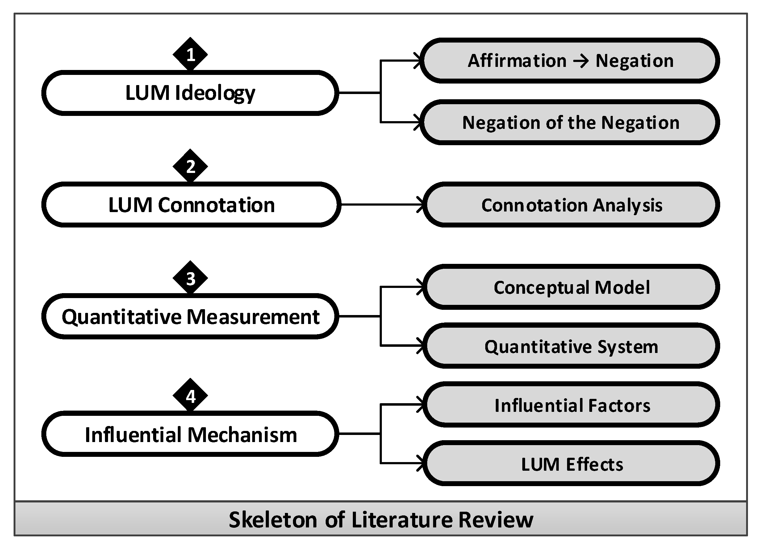
3. Literature Review

3.1. Ideological Evolution of LUM

In terms of the history of urban development and planning, the general aims have been to reflect on the problems caused by human beings in past urban development and to clarify the problems of “continuity” and “novelty” in future development [16]. Only by understanding the evolution process of things can we better understand the present and even predict the future. Therefore, it is necessary to sort out and summarize the evolution of the LUM idea as follows:

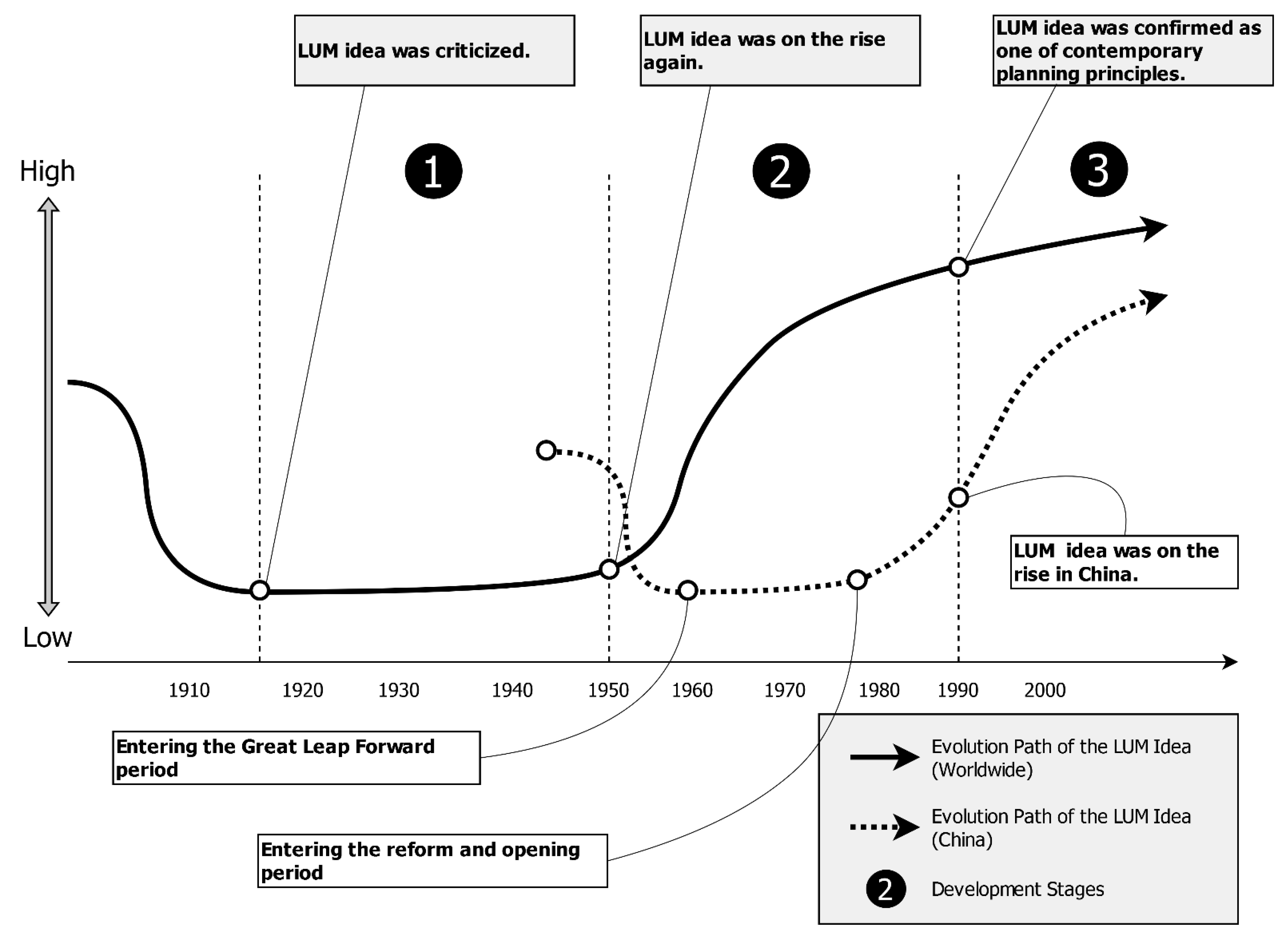
3.1.1. Historical Development of the LUM Idea

The LUM phenomenon runs through the development process of human civilization [17]. It was first used as the guiding principle of urban development in ancient Rome in 700 BC. Before that, urban development in western countries had mainly followed the guiding principle of functional “zoning” for thousands of years [9]. In ancient Rome, with the rapid increase in the urban population, the mixed-use mode of integrated production and residence appeared, which reached its heyday in the Middle Ages [14,18]. After the Industrial Revolution, with the rapid increase in the number of private cars, a large number of residents began to move from the city center to the suburbs in order to obtain a better life and living environment. In this process, the disadvantages brought by LUM gradually emerged. Therefore, urban researchers and decision-makers around the world began to criticize the LUM idea and to regard “functional zoning” as the dominant idea of urban development [9]. However, after decades of development, the idea of functional zoning also began to face various new problems and challenges in urban development. In this regard, many scholars and experts began to call for the return of the LUM idea [19]. In general, the ideological evolution process of modern LUM is an upward spiral process of “affirmation–negation–negation of the negation” [20].
  • From “Affirmation” to “Negation”
In the Middle Ages, the development of the LUM idea reached a peak in the early period, and there appeared a large number of “shop residences”, “family workshops”, and other mixing modes of production and residence [21]. In the 20th century, with the gradual maturity of industrialization, the traditional mixing mode of the workshop economy basically collapsed [22]. However, due to the lack of appropriate theoretical and practical guidance, the urban functions were increasingly chaotic, which led to the deterioration of the urban environment. In addition, the rapid increase in the number of private cars also prompted a large number of urban residents to move out of the city center and settle down in the suburbs [9]. In order to cope with these problems, scholars and experts turned to the modern functionalism approach, that is, the functional “zoning” idea [14]. The US Supreme Court’s landmark (1926) Euclid v. Ambler decision, at a time when zoning was a relatively new concept, was the first major case on zoning, and it greatly promoted zoning in cities and towns across the United States (including Canada and other countries). At the same time, together with another case of the Supreme Court (1928)—“Nectow v. City of Cambridge”, it laid an important foundation for subsequent zoning laws [23]. These two cases had a profound impact on the development of urban space, especially forming a huge restraining effect on the LUM [24].
In this context, at the International Association of Modern Architecture (CIAM) in 1933, Le Corbusier drafted and refined the Charter of Athens with the concept of functional zoning, which classified urban functions into four categories: residence, work, recreation, and transportation [6]. Based on this, cities would be divided into different regions for living, working, and recreation and a communication network would be established among these regions. This urban development mode, dominated by functional zoning, played a positive role in alleviating urban problems at that time and also played a certain role in improving the chaos caused by excessive urban land fragmentation [10,25].
In conclusion, the evolution from “affirmation” to “negation” at this stage was largely due to the problems of LUM, which had started to appear [9]. During this period, the Industrial Revolution brought about rapid economic and social development, which basically destroyed the traditional workshop economic mode. However, due to the lack of proper guidance in urban planning and development theories, most urban developments were in an unplanned and unordered state. In particular, the mixing of industry and residence led to a series of health, traffic, and housing problems [10]. At the same time, after World War II, with the great increase in private cars, a large number of residents began to move from the city center to the suburbs for better living conditions. In this context, with the Athens Charter of 1933 as the representative structure, scholars and experts began to put forward far-reaching “functional zoning” ideas.
2.
From “Negation” to “Negation of the Negation”
After World War II, the zoning-based urban development mode reached its peak. At the same time, a series of new problems was gradually exposed, such as the loss of vitality of urban diversity, the increase in traffic cost, the break in the traditional urban context, and so on. In this regard, many scholars and experts had a lot of criticism. The criticism of functional zoning came to a head with the 1961 publication of Jane Jacobs’s classic book, “The Death and Life of Great American Cities”. She believed that urban development should pay more attention to the needs of residents and explore the diversity of urban land use and an effective mixture of functional uses so as to promote the stimulation of urban vitality [7]. This book was an important basis for the modern revival of the LUM idea. At the same time, some famous scholars of the same period also joined in and criticized the disadvantages of functional zoning [26], with publications such as “Requiem for Zoning” [27], “The Zoning Game” [28], “The Zoning Dilemma” [29], and “Land Use without Zoning” [30].
Finally, the Charter of Machu Picchu was drafted at the International Association of Modern Architecture in December 1977. In the face of new challenges of urban development, some guiding principles of the Athens Charter were no longer appropriate, so it was necessary to improve them accordingly [31,32]. The LUM idea had also become popular in urban development worldwide. However, the modern LUM idea was to realize the harmonious coexistence of different land uses or functions under the framework of functional zoning. In contrast, the early LUM idea was a natural mixing state at the citywide scale. However, LUM, in the modern sense, was the integration and coordination of different land uses under the framework of functional zoning [17].
Since the 1960s, especially after the 1990s, the LUM idea has gradually developed into one of the important prerequisites for sustainable urban development [33]. At the same time, the principle of land use mix has gradually become an important part of many modern urban development strategies. For example, the concept of the “Compact City” was widely advocated by urban researchers and planners in European countries. In this concept, the LUM principle was one of its three core contents [34]. Subsequently, the Smart Growth Network proposed a mixture of residential and commercial land uses as one of the ten principles of smart growth [35]. The charter of the Congress of New Urbanism also pointed out that communities should be compact and mixed at the neighborhood level [36]. The US Centers for Disease Control and Prevention also listed LUM as an important strategy in healthy community environment proposals [37]. In addition, the American Planning Association (APA) also believes that mixed-use livable communities should be developed, which can promote efficient and sustainable land development and utilization and enhance the diversity and vitality of urban residents’ lives [38,39].
In conclusion, in the early urban development practice of this stage, the idea of functional zoning played a positive role in partially solving some contradictions in the city. At the same time, the chaotic state of industrial-age cities was improved or avoided. As industrial civilization reached its peak, new urban problems became increasingly prominent, such as the endless outward sprawl of cities and the breakdown of urban contexts. In this context, the Charter of Machu Picchu in 1977 put forward the idea of comprehensive functional mixing on the basis of criticizing the thought of functional zoning [19]. In the development of this stage, some scholars believe that it is a return from functional zoning to LUM [10]. However, according to the above literature review, this is not a simple “return” but an upward spiral from “negation” to “negation of the negation”. That is to say, the newly proposed modern LUM idea is a critical synthesis of the early LUM idea and the functional zoning idea rather than a simple succession or return. Therefore, modern LUM thought emphasizes the mixing of different uses or functions on the basis of functional zoning [10].

3.1.2. Historical Development of the LUM Idea in China

The evolution of the LUM idea was basically similar to the situation worldwide, but there was a certain time lag on the whole. The LUM idea in China first originated from the Xia, Shang, and Zhou dynasties, where the settlement spaces had the obvious features of a production–housing mix [14]. A large number of studies have also found that the ancient city of Chang’an (now Xi’an) was distributed into various urban spaces with different functions, which were mixed and integrated [40]. It can be seen that urban development at that time had already shown an obvious mixing state. In the Ming and Qing dynasties, this kind of regulation became more mature and prosperous. At that time, Xi’an not only had a large number of commercial functional spaces but also distributed many administrative, educational, cultural, residential, and other functional spaces, forming a mixed and diversified urban development space [41].
Although China has maintained the social form of mixed use, the “mixing” idea has not been paid much attention by decision-makers and urban planners. Since 1949, the evolution process of the LUM idea in China has basically had a similar spiral development process:
(1) Learning the “Soviet Model”: After the founding of New China in 1949, China began to comprehensively adopt the Soviet model and set up a planned economic system in an all-rounded way. The urban development in this stage generally emphasized industrialization. In this process, the mode of the “Danwei-based Community” was developed in China, which was inherited from the concept of the “Social Condenser” [42]. Urban spaces were divided into “Danwei” cells, in which various functions were mixed [43]. In essence, it was a mixed-use mode at the scale of local urban spaces, but a lack of planning among these cells led to a series of problems, such as the fragmentation of the overall urban layout [44].
(2) Introducing the functional “zoning” idea: In 1978, reform and open policies promoted our country’s economy, achieving rapid development; China declared that it had entered a new historical development period. Under this background, great changes took place in China’s urban planning strategy. Since the issuance of Central Document No. 13 in 1978, the urban planning strategy, which had been stalled for many years, has been revived. In order to adapt to the new development situation, the “zoning” strategy was introduced [45]. It was pointed out that the main task of the zoning strategy was to realize the balanced coordination of land resources.
(3) Raising the idea of land use mix: Since the 1990s, the LUM idea has attracted the attention of domestic experts and scholars in the field of urban development [46]. The LUM idea has become one of the important principles of urban planning and development [20]. In the 21st century, China’s urbanization development had begun to accelerate, which caused many problems that needed to be urgently solved. In this regard, some experts believed that the LUM could help reduce traffic pressure and improve the diversity and vitality of central urban areas [47,48].
From the perspective of evolution paths, the development of the LUM idea at home and abroad mainly has the following three characteristics (Figure 2): (1) Stage ① was mainly the “affirmation” of the LUM idea. With increasingly prominent negative impacts, experts and scholars had reflected and criticized the idea, that is, the “negation” of the LUM idea. Specifically, the LUM idea was rejected in the process of urban planning and management around the world. (2) Facing increasingly new problems in urban development, many scholars and experts began to reflect on the “zoning” principle and explore the revival of the LUM idea. In the process of the gradual revival of the LUM idea, the functional zoning idea would also be further developed. (3) From the perspective of China, the development and evolution of LUM were mainly concentrated in the ② and ③ stages. After the 1990s, the LUM idea was formally introduced into the planning field, which attracted the attention of many experts and scholars. After nearly 20 to 30 years of exploration and learning, the LUM idea in China began to be rapidly developed, and many provinces and cities in developed regions began to take it as one of the guiding principles in the process of planning preparations and revisions.

3.2. Conceptual Model of LUM

3.2.1. Refining the LUM Concept

The expressions used for land use mix are mainly “mixed-use development”, “mixed-use”, “mixed land use”, “land use mix”, “land use mixing” and “multifunctional land use”. Among them, “mixed-use development” (including “mixed-use”) is the most accepted term by scholars and experts and is also the basis of other related terms. According to Rowley’s definition, mixed-use development is a multi-facet concept that mainly discusses the pattern of spatial development. Specifically, it mainly includes the comprehensive expression of the texture, density, and mutual permeability of urban functional spaces [49]. According to the “Mixed-Use Development Handbook” published by the Urban Land Institute (ULI), mixed-use development is generally composed of three or more commercial uses that are intertwined with each other and have good traffic permeability [50,51]. The ULI’s definition emphasizes the integration of various land uses or functions to distinguish the concept of diversity-based LUM.
From the perspective of land use, some other scholars have also given definitions of land use mix. For example, Handy et al. thought that LUM is the relative proximity between different land uses in a certain area [52]. Ewing and Cervero believed that LUM should focus more on the diversity perspective of land uses [53]. Other scholars have claimed that LUM should be the interaction and integration between adjacent land uses or functions within a certain area [35,54].
As mentioned above, there has been some ambiguity in terms of the LUM concept. However, the consensus on the connotation expression of LUM can still be extracted. Firstly, the core objectives of LUM are as follows: (1) to promote the release of the vitality of the built environment in the city center; (2) to better serve the needs of citizens’ daily life, production, and leisure; (3) and to improve the efficiency and intensification of land use. As for the starting point and core connotation, experts and scholars in different fields tend to have different emphases. On the whole, it can be divided into two types: (1) Based on the perspective of spatial pattern and quantity proportion. To be specific, the basic starting point of LUM is to explore the spatial pattern or texture and seek the allocation proportion and distribution pattern among different land uses or functions. As emphasized by Jane Jacobs in her book, diversity is an important prerequisite for LUM [7]. In many cases, LUM measurement indicators are essentially diversity-based indicators, such as Shannon diversity and Simpson diversity. Thus, the key to LUM lies in the exploration of the spatial distribution and quantitative proportional relationship of various land uses (functions) [52,55,56]. It also needs specific analysis according to social and economic background conditions [57,58]. (2) Based on the perspective of interactivity and integrity. From the essential connotation of land use mix, it is not enough to simply consider the spatial distribution and quantity proportion of different land use types; it is often necessary to go further on this basis, for example, considering the compatibility between different land uses in the LUM context and thereby achieving the extension of the diversity-based LUM concept [33,59,60]. For the needs of the daily travel of residents, the permeability and connectivity between different land uses or functions within a region should be emphasized [17,51].

3.2.2. Conceptual Models of LUM

In order to further understand the concept of land use mix, it is necessary to form a conceptual model [17]. In this regard, Rowley first proposed a conceptual model, believing that LUM was a multi-faceted concept that was mainly composed of three elements: urban spatial texture, socioeconomic setting, and location [49]. Subsequently, Hopenbrouwer and Louw extended the components of this model, including dimension, scale, texture, and location [61]. This also provides an important theoretical basis for subsequent related research.
(1)
Dimension
Initially, Rowley’s model focused on LUM in a specific dimension, that is, the mixing situation between different land uses in the horizontal dimension [49]. Eric Hoppenbrouwer and Erik Louw extended this model to form a multi-dimensional model with shared premise dimensions, horizontal dimensions, vertical dimensions, and time dimensions [61]. The first scene is the mixed use of multiple land uses/functions in a specific location, where different land uses or functions occur within the same space unit. For example, the “family workshop” mode integrates production and living functions in the same space to achieve shared mixing [14]. The second scene is the dimension of focus in Rowley’s model, which mainly discusses the mixed-use between different land uses/functions on a two-dimensional plane. The third scene is the mixed-use situation in the vertical dimension, which usually refers to the mixed-use of multiple uses/functions on different floors in a multi-story building. A typical example is the urban commercial complex [62]. The last scene is the temporal dimension of land use mix, that is, a particular space unit is used sequentially by two or more uses or functions. For example, the theatre is used as a conference venue during the day and for screening films at night. Additionally, night market streets or squares in many cities may be used as public transport roads or parks during the day. In short, LUM can be divided into four types: one-dimensional LUM, two-dimensional LUM, three-dimensional LUM, and temporal LUM (Table 1).
From the above conceptual diagram, the first scene is the mixing of different uses or functions at one “point”, and the second and third scenes are the mixing of uses or functions at multiple “points” in the horizontal and vertical dimensions, respectively. As for the last scene, although it is also a mixing pattern of one “point”, the difference is that the uses or functions of different time dimensions, before and after the “point”, are mixed. From the above conceptual diagram, the first case is the mixture of different uses or functions at the same “point”, and the second and third cases are the mixture of uses or functions at multiple “points” in the horizontal and vertical dimensions, respectively. As for the last case, it is also a mixture of uses or functions at different times at the same “point”.
(2)
Scale
Scale is also a crucial aspect in the study of land use mix. As one of the earliest researchers in this field, Jane Jacobs advocated the discussion of land use mix at the neighborhood scale in her book “The Death and Life of Great American Cities”. She believed that the neighborhood is the basic unit for the daily autonomy and effective operation of the city [7]. In contrast, Coupland focused on the scale of single buildings and explored the mixing of different uses or functions inside the buildings as a complex [15]. Subsequently, Rowley defined four spatial scales in the LUM model: buildings, blocks, streets, and districts/neighborhoods [49]. In this model, the scale of city-/townwide was excluded because any city was necessarily mixed at the citywide scale. Hopenbrouwer and Louw made some improvements to Rowley’s model and defined the scale as four types: building, block, district, and city [61]. Some scholars have chosen the scale system in the LUM study according to the local characteristics of specific countries. For example, according to the characteristics of Indian cities, Bordoloi et al. divided the scale of LUM into three types: building, street, and ward [63]. Kong et al. used the community as their research scale to explore the specific path of land use mix in the southern suburbs of Changping, Beijing [64]. Compared with the administrative scale adopted by most studies, some scholars also chose local scales accepted by the public. For example, Grant analyzed the LUM situation of several Canadian cities from the perspectives of downtown and suburb scales [33]. At the same time, this kind of local scale was also involved in Alan’s model and Eric and Erik’s model, including: (1) city/town centers; (2) brownland sites; (3) suburban/edge-of-town locations; (4) greenfield locations [49,61].
As mentioned above, the time dimension is also one of the important dimensions in the discussion of land use mix, which mainly describes the situation where a certain spatial functional unit has multiple uses or functions at different time points [10]. From the perspective of time granularity, the frequency or time interval can be: 1 h, 24 h, one week, one month, one quarter, one year, etc. [61]. Temporal amplitude can be used to describe the duration of different uses or functions. Gehrke and Clifton et al. chose to refer to the concept of temporal availability [65]. The accessibility of a functional unit in a city is determined by its time availability [66,67]. In the temporal dimension, land use mix refers to a kind of activity-related temporal availability, that is, different uses or functions assign corresponding weights based on their respective opening hours, thus constituting the temporal land use mix situation [68].
(3)
Texture
The third key component in the LUM concept is the settlement texture. This point was covered in Rowley’s model, and he believed that LUM was essentially an important aspect of the internal texture of urban settlements [49]. It comes from three aspects: grain, density, and permeability. Among them, grain refers to the mixing pattern of different uses or functions. Roberts and Lloyd-Jones further defined grain as the size and division of city blocks [69]. The second feature is density, which is mainly reflected by the number of residents per unit area and is a key indicator of urban vitality [61]. Jacobs believed that only by ensuring 100–200 residents per unit can urban vitality be effectively guaranteed [7]. The last feature, permeability, originated from the road network pattern of the city and reflected the pedestrian movement of specific urban spaces. From this perspective, Eric Hopenbrouwer and Eric Louw also made some improvements to their model. On one hand, the first two feature elements of Alan’s model were kept: grain and density; on the other hand, a new feature of “interweaving” was put forward to reflect the distribution characteristics of different land uses/functions [70].
Based on the above, the spatial texture feature comparison of both Alan’s model and Eric and Erik’s model are shown in Table 2.

3.3. Quantitative Measurements of LUM

Although many scholars and experts have tried to quantify the situation of land use mix, no unified consensus has been formed so far, which also leads to the lack of effective guidance in urban planning and decision-making [71]. According to existing studies, the views on the LUM quantitative measurement can be divided into the following types: First, the diversity index is used to measure the LUM degree by referring to the relevant theories of landscape ecology [61,71,72]; second, the interweaving index is adopted to measure the degree of interaction among different land uses or functions from the perspective of complementarity [73]; third, the compatibility index should also be emphasized for the evaluation of LUM degree [74,75,76,77]. At the same time, Song et al. divided LUM measures into two levels: integral and divisional [35]. The former mainly reflects the balance of different land uses in the area as a whole, whereas the latter tends to reflect the evenness of land uses among districts/areas, as follows:

3.3.1. Integral Measures

According to the definition, the integral measure is related to the distribution of land uses or functions within the research scope. The first commonly used index is percentages and proportions, which indicates the percentage or proportion of a specific land use/function in a certain space. This index type can reflect the intensity of a specific land use type. Hoek defined the mixing degree through the proportional relationship between residential and non-residential building areas and carried out urban zoning based on it [78]. Some scholars have calculated the mixing degree through the proportion relationship between different land uses and functions [64,79]. Secondly, the entropy index is also one of the most common LUM measures. This index can be defined as the relative percentage of two or more land uses/functions within a certain space [80]. It reflects the balanced distribution among different land uses/functions [11]. From the existing related studies, the LUM measure generally uses the entropy index to discuss the mixed land use of built environments, thus providing important foundation preparation for further research and discussion [47,56,81,82,83,84,85]. In addition, there are two other integral LUM measures: the balance index and the Herfindahl–Hirschman index (HHI) [86,87].
Although these measures are calculated using different formulas, their connotations and results are very similar. For example, Eck and Koomen et al. found that there was almost no essential difference between the results calculated using the entropy index and the HHI index after standardization [88]. Overall, although the integral index is relatively easy to calculate, it has many inherent drawbacks. On one hand, it cannot reveal changes at the local scale because the spatial pattern of land use is “averaged” in the integral index; on the other hand, the integral index is sensitive to the size of the analysis unit [89].

3.3.2. Divisional Measures

In contrast, the divisional measure is sensitive to the change of land use patterns within the research scope, and we can observe the distribution pattern of land use from a local scale [76]. There are six commonly used divisional measures, as follows [35]: (1) Divisional measurements using buffers: this index is centered on the point of interest, which can determine the impact range of land use through the buffer zone and avoid a series of problems caused by the arbitrary administrative boundaries. (2) Atkinson index: this index corrects the imbalance measure by assigning weight to each kind of land use/function. (3) Clustering index: this index reflects the degree of clustering or mixing of specific land uses/functions. The distance parameter is included in the measurement process to consider the spatial relationship between divisions. (4) Dissimilarity index: this index mainly reflects the similarity degree between the result performance of the subdivision and the whole area in the distribution of different land uses or functions, that is, it can be used to measure the evenness of land use/function distribution among different divisions. (5) Exposure index: it reveals the interaction between two land uses/functions. (6) The Gini index can be used to measure the balance of land uses or functions between different divisions, which is similar to the dissimilarity index [90].
In essence, the above two categories of measures mainly focus on the two LUM characteristics, namely, the two basic characteristic parameters summarized by Song et al.: quantity and distance [35]. In addition, some other scholars choose the concept of “accessibility” to reflect the proximity of different land uses or functions. Abdullahi et al. and Shariff et al. claimed that the traditional diversity-based LUM measures have certain disadvantages and the proximity parameter can be introduced for further analysis [12,91]. In this regard, some scholars have added a proximity parameter into the quantitative measurement of land use mix [75,92,93,94].

3.4. Influential Factors and Effects of LUM

3.4.1. Influential Factors of LUM

Different patterns and intensities of land use are often determined by complex, influential factors [95], and the same is true for land use mix. Generally speaking, the influential factors can be divided into three categories: physical factors, socioeconomic factors, and policy factors.
(1)
Physical Factors
Physical factors affecting land use refer to the resource endowment of the land use unit and its physical environmental conditions [95], such as plot size, shape, terrain, geological conditions, location, traffic conditions, etc. By analyzing the residential LUM in the Tai‘an and Wanhua districts of Taipei, Jung-Tsong Hsu found that the frontage road widths, building forms, adjacency of the CBD, and street corners were important and influential factors of commercial and residential LUM [96]. Chih-Hung Hsu also obtained similar outcomes through regression analysis and canonical correlation analysis. Factors such as the street size and frontage road width could affect the LUM pattern and situation [97]. In addition, traffic conditions would also significantly affect the pattern and intensity of land use mix. Many studies have shown that accessibility is one of the most important factors affecting the formation of different land use patterns [98]. For land use mix, accessibility is also an important factor [99]. In this regard, some scholars have used regression methods to prove that the spatial accessibility characteristics of the overall road network structure have an important influence on the LUM pattern [13,97]. Cervero and Kang et al. and Jun discussed the impact of BRT (bus rapid transit) on land use change and land value, and the results showed that the distance from the nearest bus station and the distance from the nearest subway station were important influencing factors [100,101]. Yahsuan Wu also confirmed that the distance to the nearest subway station and the distance to the nearest bus station had a significant impact on LUM by using a geographically weighted regression model [102].
(2)
Socioeconomic Factors
The socioeconomic factor is one of the main perspectives for exploring land use and urban spatial structure. Generally, it includes demographic characteristics, industrial structure, income level, land price, regional culture, and other characteristic factors. Talen believed that socioeconomic factors would affect the LUM, so she chose income, race, age, household type, and housing tenure as the basic factors. The least square method (OLS) and maximum likelihood method (ML) were used to test the correlation between the five factors and mixed diversity [92]. The study also showed that, before the guidance of planning, LUM was a natural urban development state, which is slowly formed under the drive of the daily needs of residents. Taking Taiwan as an example, Liren Yang found that LUM was largely influenced by certain social and economic factors, including the economic structure of the traditional family, the surplus labor force of the family, the organizational structure of the family, and the balance between production and life needs [103]. Jung-Tsong Hsu also pointed out that the size of commercial areas is also one of the important factors affecting LUM in residential areas [96]. Yaolin Chang and Shuwei Huang further considered factors such as population, residential areas, and commercial areas to explore the impact on the temporal and spatial changes of LUM [13,104]. In the process of exploring the LUM influential mechanism, Wanjung Tsai further introduced the “CBD Ratio” index, which reflects the vitality of the regional economy through the development intensity of different business types.
(3)
Policy Factors
Many scholars believe that policies and regulations are also important factors affecting land use change [105]. For LUM, a strong policy foundation is also essential [106]; without effective policy guidance, many mixed-use projects would be difficult to implement [107]. However, at present, many countries (regions) have not clearly put forward their land use mix policies or regulations. For example, the land use regulations of Illinois and the zoning regulations of Cleveland in the United States do not include the enforcement regulations related to land use mix [108]. Moreover, single-use development is advocated in Dutch local zoning plans and Canadian general development plans, which have created considerable obstacles and restrictions for LUM [8,61]. Of course, many developed countries (regions) have made successful attempts. The concept of “White Sites” in Singapore was put forward and implemented by the Urban Redevelopment Authority (URA) in 1995. Based on this policy, developers can flexibly decide the nature of land use. It also allows the mixed use of various functional uses [109]. The statutory plan system in Hong Kong is another successful LUM example; it provides for one dominant use and permits other related uses to ensure land use compatibility and mixing [110]. In Taiwan, a land use zoning system is implemented to stipulate the control contents of different uses, such as land use types and intensity [13,97,99,111].
Based on the above analysis, it can be concluded that the influential factors of mixed land use include physical factors, socioeconomic factors, and policy factors (See Table 3). Among them, physical factors mainly include street area, frontage road width, location, accessibility, and other factors, which mainly emphasize the differences in resource endowments and physical environments within each street or district. The socioeconomic factors mainly reflect the differences in social and economic development backgrounds among streets, districts, or even cities, which are mainly composed of demographic characteristics, industrial structure, income, land price, commercial development level, and other related factors. As for policies and regulations, it reflects the influence of relevant policies and regulations of the government on land use, which is mainly composed of whether there are corresponding land use mix policies, compatibility guidance policies, and land use zoning policies.

3.4.2. Effects of LUM

As stated by Grant, land use mix is part of the urban sustainable development strategy, and its effects can be expected [33]. In its planning policy statement, the UK government pointed out that the promotion of the land use mix strategy can bring a series of effects, including reducing the travel demand of residents, increasing the utilization rate of public transport, improving the diversity of urban development, and promoting the vitality of the city [15,61,73]. In general, LUM may bring a series of positive effects, which can be summarized as socioeconomic effects and travel-related effects. Of course, every coin has two sides. If the planning and management are not properly done, the LUM may also cause certain negative effects.
(1)
Positive: socioeconomic effects
Land use mix means that it is necessary to integrate a variety of different uses/functions (including two-dimensional and three-dimensional) to improve the efficiency of land use in the context of relatively high-density development [111]. Intuitively, LUM will bring higher land values and increase output [96]. Of course, the impact of LUM on land prices and housing prices should be said to be the most direct reflection. In the study of the relationship between LUM and housing price, many scholars hold the view that LUM will cause a decline in housing prices. In this regard, Song and Knaap found that LUM can also improve housing prices as long as reasonable planning and design are adopted [11]. Yuhsin Tsai et al. took the TOD stations in Taipei City as an example to conduct an in-depth study on the relationship between LUM and housing price, and the results also showed that moderate LUM could increase the price of residential land [113]. In the process of exploring the influencing factors of residential land values, some scholars have found that the mixed diversity of land use has a significant positive impact on residential land values [114]. Sifan Zhao also found that LUM policies can improve the production of land resources in this region. Under the rational allocation of land uses/functions, the output can also be further increased [115,116]. Some other scholars have also confirmed that certain agglomeration and input–output benefits can be obtained through high-density and efficient land use/function organization [117,118]. In addition, for local governments, the primary reason to promote the LUM strategy is to increase the government’s tax revenue. For example, Horton Plaza in San Diego, Southern California, contributes USD 12 million in tax revenue to the government every year [13,96].
In addition, LUM will also contribute to the construction of a good social environment. When the government works for the public good, its goal is to create a good social environment, and the LUM strategy is one of the possible solutions [96]. In many urban development practices, local governments would adopt the LUM strategy in the process of urban renewal, introducing multiple uses or functions, such as housing, work, leisure, and entertainment, to revitalize decayed areas [119,120]. Some studies have also found that LUM will affect the suitability of residential environments [121,122,123,124]. Nabil and Eldayem et al. took the concept of social capital as a starting point and found that with the improvement of the LUM degree, the social capital in the region would also accumulate, thus creating the prerequisite for sustainable urban development [9]. Moreover, another issue closely related to LUM is home–work separation. Driven by the market mechanism, different land uses/functions will find the best location in a space through a reasonable combination layout, which forms a large number of home–work separation phenomena. In this regard, some scholars believe that LUM is one of the feasible solutions [125,126]. At the same time, according to the report of the British Department of Environment, the LUM strategy will promote the improvement of urban diversity and vitality, thus creating a relatively more comfortable and secure social environment [15,61].
(2)
Positive: travel-related effects
For a long time, the interactive relationship between transportation and land use has attracted the attention of many scholars. The idea of land use mix was put forward to a large extent to improve the convenience of the daily travel of residents [9]. Under the guidance of the traditional idea of functional zoning, residents have mostly relied on cars, which is not conducive to the development of walking and bicycle lanes and public transportation systems, and the form of land use tends to be simple. In contrast, guided by the LUM idea, it is conducive to the rational development of the city, and the urban transport system tends to be compounded (walking, cycling, public transport, driving, and other modes co-exist) [125]. LUM helps to shorten the distance between the starting point and the end point of travel, thus reducing the average travel time and dependence on cars and replacing them with walking, cycling, and public transport [9,127,128,129,130,131]. Robert Cervero et al. further confirmed that the use of public transport in mixed-use centers is 5–10% higher than that in single-use centers [81,87].
It is generally believed that the land use pattern will affect the urban transportation system [132,133]. For LUM, it mainly affects the travel behavior of urban residents. As a typical city with a high population density, Hong Kong adopted a combination of rail transit and LUM to realize development with minimal land resources and to ensure the high accessibility of the urban transportation system [134]. Pocheng Hsiao took Taipei City as an example to discuss the impact of LUM on residents’ travel frequency and mode of travel [135]. It was found that the traditional development mode of home–work separation increased the average travel frequency of residents to a certain extent as well as the load of the traffic system. There are scholars who take different views. Junfang Li et al. conducted an empirical study in Tokyo, Japan, and found that LUM had a weak impact on the passenger flow of rail transit stations [136]. In general, the effects of LUM on travel can be summarized as follows: (1) LUM can take care of about 1% of residents’ travel needs; (2) the LUM development mode is more intensive and suitable for high-density urban development scenarios; (3) LUM can promote the orderly allocation of various land uses/functions, take into account the daily travel needs of residents, and thus improve the attractiveness of cities [96].
(3)
Negative: chaos and conflict
Although the LUM can bring many positive effects, it is not a panacea. Disorderly and excessive LUM may lead to the mutual exclusion of different uses/functions, thus causing the deterioration of living environments and ultimately affecting the security, convenience, and comfort of cities [137]. To be specific, the negative effects of LUM are mainly reflected in two aspects: on one hand, the mixture of incompatible land uses/functions often causes certain “conflicts”. For example, it is well known that the placement of industrial uses in residential areas can have a significant negative effect. Therefore, in urban development planning, various control systems (such as land use zoning) should be adopted to isolate incompatible uses/functions to ensure the improvement of the social environment and vitality [97]. In this regard, Grant also pointed out that compatibility is one of the core contents of land use mix, and without such consideration, certain negative effects will emerge [17]. From the perspective of urban residents, it is mainly reflected as a “Not-In-My-Back-Yard (NIMBY)” effect. This effect is caused by the phenomenon of “incompatible” land uses or functions, which leads to the aversion of many residents to the LUM mode [33,138,139]. Therefore, it is essential to consider compatibility or externality characteristics in the study of land use mix [74,76,77]. On the other hand, blindly pursuing mixed diversity can easily go to the other extreme, that is, it can cause disorder and chaos in land uses or functions. As Kevin Lynch said, an excessive pursuit of diversity in the LUM strategy will only lead to a chaotic development state [140]. Therefore, in the development strategy of land use mix, comprehensive consideration should be made based on the background of social and economic development and the nature of land use rather than treating it as an “independent” policy [61].
In addition to the economic and social benefits mentioned above, environmental benefits are also an indispensable part of LUM. Only by achieving the balance and unity of the three can the comprehensive benefits be maximized. However, environmental benefits are often not intuitively reflected but are accompanied by the realization of economic and social benefits. On one hand, while improving land use efficiency, LUM will relatively reduce the occupation of ecological land, thus avoiding the loss of environmental benefits. On the other hand, LUM will reduce residents’ dependence on motor vehicles and reduce energy consumption and environmental pollution while reducing the demand for transportation.
Based on the above analysis, LUM has both positive and negative impacts on the urban environment. What we should do is enlarge the positive effects and effectively avoid the possible negative effects. Firstly, from the perspective of the social economy, LUM can improve the efficiency and intensity of land use so as to improve the value of land or property and increase tax revenues. At the same time, LUM can improve the vitality of the urban environment by integrating public service facilities. Secondly, from the perspective of transportation, LUM effectively reduces the travel needs of urban residents and their dependence on cars and replaces them with complex travel modes such as walking, cycling, and public transportation. Finally, from the perspective of negative effects, LUM may result in incompatibility between uses/functions as well as chaotic urban spatial patterns caused by the excessive pursuit of diversity. Taking these three perspectives into consideration, LUM can integrate different types of uses or functions and increase their diversity under the condition of compatibility so as to improve the comprehensive social, economic, and environmental benefits of urban space and achieve sustainable urban development (see Figure 3).

4. Discussion and Conclusions

To clarify the research status of land use mix, it is expected to provide beneficial guidance for sustainable urban development. This study has conducted a literature review from four aspects, including ideological evolution, conceptual models, quantitative measures, and influential factors and effects. On this basis, the following conclusions are summarized:

4.1. Theoretical Framework Lags Behind

With the rapid development of the social economy, a large number of land use mix phenomena have appeared in major cities. However, the existing academic research on this is mostly sporadic, with a lack of systematic discussion, which also causes ineffective guidance in the process of urban development. Therefore, it is necessary to construct a theoretical framework for land use mix. Of course, the construction of a theoretical framework is not accomplished overnight. On one hand, it requires a very clear understanding of the practical problems. On the other hand, it is necessary to refine the existing framework or basic theory. In other words, only through the scientific connection between theory and practice can we construct an effective theoretical framework and realize the scientific guidance of land use mix.

4.2. Mixing or Zoning?

Both scholars and planners have generally accepted or tacitly accepted the conclusion that “mixing” and “zoning” are sets of opposing concepts. However, we think that the two theories have advantages and disadvantages and are complementary to each other. From the perspective of ideological evolution, this process conforms to the law of “negation of negation”, in Hegel’s dialectics. In other words, it is an upward spiral process from “affirmation” to “negation” and then to “negation of negation”. Therefore, the modern land use mix idea is not a simple repetition of the early idea but a critical inheritance of the early “mixing” and “zoning” ideas, which combines the advantages of the two and makes up for their respective deficiencies. In fact, many successful samples of land use mix are also formed on the basis of urban functional zoning. Therefore, in the specific study of land use mix, it is necessary to conduct an in-depth exploration of land use mix and not to ignore the impact of functional zoning.

4.3. Reconstructing a Conceptual Model

Through the discussion and analysis above, it can be seen that the concept and objective of LUM are fuzzy, and no consensus has yet been reached. The ambiguity of the concept has brought many obstacles to further research. Research on the quantitative measurements and influencing mechanisms of land use mix should be carried out from this point of view. In view of this, it is very necessary to put forward a set of operational conceptual models as a guide. Specifically, on the basis of Alan’s model and Eric and Erik’s model, combined with the conceptual connotation of LUM, a set of possible new conceptual models is proposed. It is composed of dimension, scale, and texture, which are used to locate the research objective, determine the grain and extent, and reflect the characteristic texture. Specifically, in the process of quantitative research, it is necessary to take a position from the perspective of dimension and scale, according to the research objectives and background, and then reflect the characteristics of LUM through various spatial texture parameters. As for the spatial texture characteristic, in addition to the “quantity” and “distance” parameters proposed by Song, Merlin, and Rodriguez [35], it is necessary to add the “attribute” parameter to fully reflect the essential characteristics of land use mix [77].

4.4. Unclear Influencing Mechanism

According to our review of existing research, it is found that the quantitative research of LUM by scholars at present mainly focuses on the measurement aspect, which belongs to the descriptive method of geography. However, as David Harvey argued in his book “Explanation in Geography”, the study of geographical phenomena should consist of two processes, namely, description and interpretation [141], as well as the land use mix phenomenon. However, there are few studies on the causes and influencing factors of land use mix. Therefore, it is necessary to further explore the influencing mechanism behind the land use mix phenomenon on the basis of quantitative measurements so as to provide a better reference for planners and decision-makers.

Author Contributions

Conceptualization, Y.Z. and G.L.; Data curation, X.J.; Formal analysis, X.J. and X.W. (Xiaoying Wang 1); Funding acquisition, Y.Z.; Methodology, Y.Z. and G.L.; Resources, X.J., X.W. (Xiaoying Wang 1) and Y.C.; Validation, Z.X.; Writing—original draft, Y.Z.; Writing—review and editing, G.L., Z.X., Y.C. and X.W. (Xueqi Wang 2). All authors have read and agreed to the published version of the manuscript.

Funding

This research was funded by the Ningbo Social Science Research Base Project (Grant No. JD5-ZD40 and Grant No. JD5-ZD41).

Institutional Review Board Statement

Not applicable.

Informed Consent Statement

Not applicable.

Data Availability Statement

Not applicable.

Conflicts of Interest

The authors declare no conflict of interest.

References

  1. Bakır, N.Y. Replacing “mixed use” with “all mixed up” concepts; a critical review of Turkey metropolitan city centers. Land Use Policy 2020, 97, 104905. [Google Scholar] [CrossRef]
  2. Cui, X.; Huang, W.; Deng, W.; Jia, C. Spatial Patterns, Drivers and Heterogeneous Effects of PM2.5: Experience from China. Pol. J. Environ. Stud. 2022, 31, 5633–5647. [Google Scholar] [CrossRef]
  3. Cui, X.; Huang, S.; Liu, C.; Zhou, T.; Shan, L.; Zhang, F.; Chen, M.; Li, F.; de Vries, W.T. Applying SBM-GPA Model to Explore Urban Land Use Efficiency Considering Ecological Development in China. Land 2021, 10, 912. [Google Scholar] [CrossRef]
  4. Mumford, E. CIAM urbanism after the Athens charter. Plan. Perspect. 1992, 7, 391–417. [Google Scholar] [CrossRef]
  5. Gold, J.R. Creating the Charter of Athens: CIAM and the functional city, 1933–43. Town Plan. Rev. 1998, 69, 225–247. [Google Scholar] [CrossRef]
  6. Congrès International d’Architecture Modern (C.I.A.M.). The Athens Charter; Congrès International d’Architecture Modern (C.I.A.M.): Athens, Greece, 1933. [Google Scholar]
  7. Jacobs, J. The Death and Life of Great American Cities: The Failure of Town Planning; Penguin Books: London, UK, 1984. [Google Scholar]
  8. Stead, D.; Hoppenbrouwer, E. Promoting an urban renaissance in England and the Netherlands. Cities 2004, 21, 119–136. [Google Scholar] [CrossRef]
  9. Nabil, N.A.; Eldayem, G.E.A. Influence of mixed land-use on realizing the social capital. HBRC J. 2015, 11, 285–298. [Google Scholar] [CrossRef] [Green Version]
  10. Huang, Y. A Study of Urban Mixed-Use Development in Theory and Practice: The Case of Shanghai; Tongji University: Shanghai, China, 2008. [Google Scholar]
  11. Song, Y.; Knaap, G.-J. Measuring the effects of mixed land uses on housing values. Reg. Sci. Urban Econ. 2004, 34, 663–680. [Google Scholar] [CrossRef]
  12. Abdullahi, S.; Pradhan, B.; Mansor, S.; Shariff, A.R.M. GIS-based modeling for the spatial measurement and evaluation of mixed land use development for a compact city. GIScience Remote Sens. 2015, 52, 18–39. [Google Scholar] [CrossRef]
  13. Huang, S. The Analysis of Measurements and Factors of the Spatial Pattern of Mixed Land Use; National Cheng Kung University: Tainan, Taiwan, 2008. [Google Scholar]
  14. Zhu, X. Research on the Evolvement, Mechanism and Construction of Work-Live Community Based on Mixed-Use Development. Ph.D. Thesis, Zhejiang University, Hangzhou, China, 2011. [Google Scholar]
  15. Coupland, A. Reclaiming the City: Mixed Use Development; E & FN Spon: London, UK, 1997. [Google Scholar]
  16. Zhang, J. (Ed.) A Brief History of Western Urban Planning Thought; Southeast University Press Nanjing: Nanjing, China, 2005. [Google Scholar]
  17. Herndon, J.D. Mixed-Use Development in Theory and Practice: Learning from Atlanta’s Mixed Experiences; Georgia Institute of Technology: Atlanta, GA, USA, 2011. [Google Scholar]
  18. Witherspoon, R.; Abbett, J.P.; Gladstone, R.M. Mixed-Use Developments: New Ways of Land Use; Urban Land Institute: Washington, DC, USA, 1976. [Google Scholar]
  19. Congrès International d’Architecture Modern (C.I.A.M.). The Charter of Machu Picchu. J. Archit. Res. 1977, 7, 5–9. [Google Scholar]
  20. Zhou, L. On urban land use mix. City Plan. Rev. 1992, 61. [Google Scholar]
  21. Goetz, H.-W. Life In The Middle Ages: From the Seventh to the Thirteenth Century; Rowan, S., Ed.; University of Notre Dame Press: Notre Dame, IN, USA, 1994. [Google Scholar]
  22. Zhou, C. Urban Spatial Structure and Form; Science Press Beijing: Beijing, China, 2007. [Google Scholar]
  23. Mandelker, D.R. Planning and Control of Land Development: Cases and Materials; Social Science Electronic Publishing: Rochester, NY, USA, 1980. [Google Scholar]
  24. Grant, J. Encouraging Mixed Use in Practice. In Incentives, Regulations and Plans; Knaap, G.-J., Haccoû, H.A., Clifton, K.J., Frece, J.W., Eds.; Edward Elgar Publishing: Cheltenham, UK, 2007. [Google Scholar]
  25. Huang, Y. Opportunities and Challenges of Mixed-Use Development in Shanghai. Urban Probl. 2008, 3, 35–37. [Google Scholar] [CrossRef]
  26. Talen, E. Zoning for and against Sprawl: The Case for Form-Based Codes. J. Urban Des. 2013, 18, 175–200. [Google Scholar] [CrossRef]
  27. Reps, J.W. Requiem for zoning. Zoning Dig. 1964, 16, 57. [Google Scholar]
  28. Babcock, R.F. The Zoning Game: Municipal Practices and Policies; University of Wisconsin Press: Madison, WI, USA, 1966. [Google Scholar]
  29. Mandelker, D.R. The Zoning Dilemma: A Legal Strategy for Urban Change; Bobbs-Merrill: Indianapolis, IN, USA, 1971. [Google Scholar]
  30. Siegan, B.H. Land Use without Zoning; Lexington Books: Lexington, MA, USA, 1972. [Google Scholar]
  31. Zhao, Y. The Study of Planning System for Mixed Land Use—Taking Shanghai as an Example. Master’s Thesis, Shanghai Jiao Tong University, Shanghai, China, 2014. [Google Scholar]
  32. Xu, X.; Zhou, Y.; Ning, Y. Urban Geography, 2nd ed.; Higher Education Press: Beijing, China, 2009. [Google Scholar]
  33. Grant, J. Mixed Use in Theory and Practice: Canadian Experience with Implementing a Planning Principle. J. Am. Plan. Assoc. 2002, 68, 71–84. [Google Scholar] [CrossRef]
  34. Burton, E. Measuring urban compactness in UK towns and cities. Environ. Plan. B Plan. Des. 2002, 29, 219–250. [Google Scholar] [CrossRef]
  35. Song, Y.; Merlin, L.; Rodriguez, D. Comparing measures of urban land use mix. Comput. Environ. Urban Syst. 2013, 42, 1–13. [Google Scholar] [CrossRef]
  36. Congress for the New Urbanism (Ed.) Charter of the New Urbanism; McGraw-Hill Education: New York, NY, USA, 2013. [Google Scholar]
  37. Centers for Disease Control and Prevention. The CDC Guide to Strategies to Increase Physical Activity in the CommunityNational; U.S. Department of Health and Human Services: Atlanta, GA, USA, 2011.
  38. Sultana, S.; Powell, W. Planning the Good Community: New Urbanism in Theory and Practice (review). Southeast. Geogr. 2009, 49, 308–312. [Google Scholar] [CrossRef]
  39. American Planning Association. APA Policy Guide on Smart Growth; American Planning Association: Chicago, IL, USA, 2012. [Google Scholar]
  40. Wright, A. Chang’An. In Cities of Destiny; Toynbee, A., Ed.; Thames and Hudson Ltd.: London, UK, 1976. [Google Scholar]
  41. Huang, M. Preliminary Study on the Residential Forms and Their Open Characteristics in the Southeast Area of Xi’an Ming City. Master’s Thesis, Xi’an University of Architecture and Technology, Xi’an, China, 2018. [Google Scholar]
  42. Chai, Y.; Chen, L.; Zhang, C. Transformation of Danwei System: An Angle of View on City Changes in China. World Reg. Stud. 2007, 16, 60–69. [Google Scholar] [CrossRef]
  43. Huang, L. Mixed Land Use for Urban Development: Models and Strategies. Trop. Geogr. 2012, 32, 402–408. [Google Scholar] [CrossRef]
  44. Zhang, J.; Luo, Z. New China Urban and Rural Planning Thoughts; Southeast University Press: Nanjing, China, 2013. [Google Scholar]
  45. Zhang, T. Urban Planning in the 21st century: Looking at China with America as Reference. Planners 1998, 14, 24–27. [Google Scholar]
  46. Weng, L. Introduction of Urban Land Use Mix; Tongji University: Shanghai, China, 1990. [Google Scholar]
  47. Qian, L. The Research on the Relationship between Degree of Mixed Urban Land-use and Spatial Distribution of Trips: In Case Study of Main Districts in Nanjing. Urban Res. 2000, 3, 7–10. [Google Scholar]
  48. Bao, Q.; Jiang, Y. The mixed-use and development of CBD. Urban Probl. 2007, 9, 52–56. [Google Scholar] [CrossRef]
  49. Rowley, A. Mixed-use development: Ambiguous concept, simplistic analysis and wishful thinking? Plan. Pract. Res. 1996, 11, 85–98. [Google Scholar] [CrossRef]
  50. Urban Land Institute. Mixed-Use Development Handbook; Urban Land Institute: Washington, DC, USA, 1987. [Google Scholar]
  51. Schwanke, D.; Urban Land Institute. Mixed-Use Development Handbook; Urban Land Institute: Washington, DC, USA, 2003. [Google Scholar]
  52. Handy, S.L.; Boarnet, M.G.; Ewing, R.; Killingsworth, R.E. How the built environment affects physical activity: Views from urban planning. Am. J. Prev. Med. 2002, 23, 64–73. [Google Scholar] [CrossRef] [PubMed]
  53. Ewing, R.; Cervero, R. Travel and the Built Environment. J. Am. Plan. Assoc. 2010, 76, 265–294. [Google Scholar] [CrossRef]
  54. Saelens, B.E.; Sallis, J.F.; Frank, L.D. Environmental Correlates of Walking and Cycling: Findings From the Transportation, Urban Design, and Planning Literatures. Ann. Behav. Med. 2003, 25, 80–91. [Google Scholar] [CrossRef]
  55. Hong, M.; Jin, F. Ideology and the Implication of Land Use in a Compact City. China Land Sci. 2010, 24, 10–13. [Google Scholar] [CrossRef]
  56. Bao, Y. Measure of Mixed Urban Land Use: Case of Shenzhen City. Hubei Agric. Sci. 2016, 55, 5794–5797+5801. [Google Scholar] [CrossRef]
  57. Cervero, R. Land-Use Mixing and Suburban Mobility. Transp. Q. 1988, 42, 429–446. [Google Scholar]
  58. Angotti, T.; Hanhardt, E. Problems and Prospects for Healthy Mixed-use Communities in New York City. Plan. Pract. Res. 2001, 16, 145–154. [Google Scholar] [CrossRef]
  59. Mashhoodi, B.; Pont, M.Y.B. Studying land-use distribution and mixed-use patterns in relation to density, accessibility and urban form. In Proceedings of the ISUF 2011: 18th International Seminar on Urban Form: Urban Morphology and the Post-Carbon City, Montreal, QC, Canada, 26–29 August 2011. [Google Scholar]
  60. Zhuang, S.; Ren, L. Discussions on the Mixed-uses Development Strategy of Urban Land. J. Civ. Eng. Manag. 2011, 28, 33–37. [Google Scholar]
  61. Hopenbrouwer, E.; Louw, E. Mixed-use Development: Theory and Practice in Amsterdam’s Eastern Docklands. Eur. Plan. Stud. 2005, 13, 968–983. [Google Scholar] [CrossRef]
  62. Goodchild, B. Learning the Lessons of Housing Over Shops Initiatives. J. Urban Des. 1998, 3, 73–92. [Google Scholar] [CrossRef]
  63. Bordoloi, R.; Mote, A.; Sarkar, P.P.; Mallikarjuna, C. Quantification of Land Use diversity in the context of mixed land use. Procedia Soc. Behav. Sci. 2013, 104, 563–572. [Google Scholar] [CrossRef] [Green Version]
  64. Kong, H.; Sui, D.Z.; Tong, X.; Wang, X. Paths to mixed-use development: A case study of Southern Changping in Beijing, China. Cities 2015, 44, 94–103. [Google Scholar] [CrossRef]
  65. Gehrke, S.R.; Clifton, K.J. Toward a spatial-temporal measure of land-use mix. J. Transp. Land Use 2016, 9, 171–186. [Google Scholar] [CrossRef]
  66. McNally, M.G.; Kulkarni, A. Assessment of Influence of Land Use–Transportation System on Travel Behavior. Transp. Res. Rec. 1997, 1607, 105–115. [Google Scholar] [CrossRef]
  67. Kwan, M.-P. Beyond Space (As We Knew It): Toward Temporally Integrated Geographies of Segregation, Health, and Accessibility. Ann. Assoc. Am. Geogr. 2013, 103, 1078–1086. [Google Scholar] [CrossRef]
  68. Chen, Y.; Ravulaparthy, S.; Deutsch, K.; Dalal, P.; Yoon, S.Y.; Lei, T.; Goulias, K.G.; Pendyala, R.M.; Bhat, C.R.; Hu, H.-H. Development of Indicators of Opportunity-Based Accessibility. Transp. Res. Rec. 2011, 2255, 58–68. [Google Scholar] [CrossRef]
  69. Cervero, R.; Kockelman, K. Travel demand and the 3Ds: Density, diversity, and design. Transp. Res. Part D Transp. Environ. 1997, 2, 199–219. [Google Scholar] [CrossRef]
  70. Rodenburg, C.A.; Vreeker, R.; Nijkamp, P. Multifunctional Land Use: An Economic Perspective. In The Economics of Multifunctional Land Use; Nijkamp, P., Rodenburg, C., Vreeker, R., Eds.; Shaker Publishing B.V.: Maastricht, Germany, 2003. [Google Scholar]
  71. Handy, S. Regional transportation planning in the US: An examination of changes in technical aspects of the planning process in response to changing goals. Transp. Policy 2008, 15, 113–126. [Google Scholar] [CrossRef]
  72. Leslie, E.; Coffee, N.; Frank, L.; Owen, N.; Bauman, A.; Hugo, G. Walkability of local communities: Using geographic information systems to objectively assess relevant environmental attributes. Health Place 2007, 13, 111–122. [Google Scholar] [CrossRef] [PubMed]
  73. Priemus, H.; Nijkamp, P.; Dieleman, F. Meervoudig Ruimtegebruik: Stimulansen en Belemmeringen (Multiple Use of Space: Incentives and Barriers); Delft University Press: Delft, The Netherlands, 2000. [Google Scholar]
  74. Taleai, M.; Sharifi, A.; Sliuzas, R.; Mesgari, M. Evaluating the compatibility of multi-functional and intensive urban land uses. Int. J. Appl. Earth Obs. Geoinf. 2007, 09, 375–391. [Google Scholar] [CrossRef]
  75. Manaugh, K.; Kreider, T. What is mixed use? Presenting an interaction method for measuring land use mix. J. Transp. Land Use 2013, 6, 63–72. [Google Scholar] [CrossRef] [Green Version]
  76. Tian, L.; Liang, Y.; Zhang, B. Measuring residential and industrial land use mix in the peri-urban areas of China. Land Use Policy 2017, 69, 427–438. [Google Scholar] [CrossRef]
  77. Zhuo, Y.; Zheng, H.; Wu, C.; Xu, Z.; Li, G.; Yu, Z. Compatibility mix degree index: A novel measure to characterize urban land use mix pattern. Comput. Environ. Urban Syst. 2019, 75, 49–60. [Google Scholar] [CrossRef]
  78. Van Den Hoek, J.W. The MXI (Mixed-use Index) as Tool for Urban Planning and Analysis. In Corporations and Cities: Envisioning Corporate Real Estate in the Urban Future; Publikatieburo Bouwkunde: Delft, The Netherlands, 2008; pp. 1–15. [Google Scholar]
  79. Shi, B.; Yang, J. Scale, distribution, and pattern of mixed land use in central districts: A case study of Nanjing, China. Habitat Int. 2015, 46, 166–177. [Google Scholar] [CrossRef]
  80. Turner, M.G.; Gardner, R.H.; O’Neill, R.V. Landscape Ecology in Theory and Practice: Pattern and Process; Spinger: New York, NY, USA, 2001. [Google Scholar]
  81. Cervero, R. Mixed Land-Uses and Commuting: Evidence From the American Housing Survey. Transp. Res. Part A Policy Pract. 1996, 30, 361–377. [Google Scholar] [CrossRef]
  82. Frank, L.D.; Engelke, P. Multiple Impacts of the Built Environment on Public Health: Walkable Places and the Exposure to Air Pollution. Int. Reg. Sci. Rev. 2005, 28, 193–216. [Google Scholar] [CrossRef]
  83. Frank, L.D.; Greenwald, M.J.; Kavage, S.; Devlin, A. An Assessment of Urban Form and Pedestrian and Transit Improvements as an Integrated GHG Reduction Strategy; WSDOT Research Report WA-RD 765.1; Washington State Department of Transportation: Washington, DC, USA, 2011.
  84. Nasri, A.; Zhang, L. Impact of Metropolitan-Level Built Environment on Travel Behavior. Transp. Res. Rec. J. Transp. Res. Board 2012, 2323, 75–79. [Google Scholar] [CrossRef] [Green Version]
  85. Zhang, L.; Hong, J.; Nasri, A.; Shen, Q. How Built Environment Affects Travel Behavior: A Comparative Analysis of the Connections Between Land Use and Vehicle Miles Traveled in US cities. J. Transp. Land Use 2012, 5, 40–52. [Google Scholar] [CrossRef] [Green Version]
  86. Ordover, J.A.; Sykes, A.O.; Willig, R.D. Herfindahl Concentration, Rivalry, and Mergers. Harv. Law Rev. 1982, 95, 1857–1874. [Google Scholar] [CrossRef]
  87. Cervero, R.; Duncan, M. Walking, Bicycling, and Urban Landscapes: Evidence From the San Francisco Bay Area. Am. J. Public Health 2003, 93, 1478–1483. [Google Scholar] [CrossRef] [PubMed]
  88. Eck, J.R.v.; Koomen, E. Characterising urban concentration and land-use diversity in simulations of future land use. Ann. Reg. Sci. 2008, 42, 123–140. [Google Scholar] [CrossRef] [Green Version]
  89. Dark, S.J.; Bram, D. The Modifiable Areal Unit Problem (MAUP) in Physical Geography. Prog. Phys. Geogr. Earth Environ. 2007, 31, 471–479. [Google Scholar] [CrossRef] [Green Version]
  90. Brown, M.C. Using Gini-Style Indices to Evaluate the Spatial Patterns of Health Practitioners: Theoretical Considerations and an Application based on Alberta Data. Soc. Sci. Med. 1994, 38, 1243–1256. [Google Scholar] [CrossRef] [PubMed]
  91. Phua, M.H.; Minowa, M. A GIS-based multi-criteria decision making approach to forest conservation planning at a landscape scale: A case study in the Kinabalu Area, Sabah, Malaysia. Landsc. Urban Plan. 2005, 71, 207–222. [Google Scholar] [CrossRef]
  92. Talen, E. Land Use Zoning and Human Diversity: Exploring the Connection. J. Urban Plan. Dev. 2005, 131, 214–232. [Google Scholar] [CrossRef]
  93. Abdullahi, S.; Pradhan, B.; Jebur, M.N. GIS-based sustainable city compactness assessment using integration of MCDM, Bayes theorem and RADAR technology. Geocarto Int. 2014, 30, 365–387. [Google Scholar] [CrossRef]
  94. Zheng, H.; Wu, C.; Zheng, S.; Zhuo, Y.; Zhang, Q. The Spatial Consistency between Compact City and Mixed Land Use Development: A Case Study of Shanghai. China Land Sci. 2016, 30, 35–42. [Google Scholar] [CrossRef]
  95. Hoshino, S. Multilevel Modeling on Farmland Distribution in Japan. Land Use Policy 2001, 18, 75–90. [Google Scholar] [CrossRef]
  96. Hsu, J. Study on the Compatibility Analysis of Land Mixed-Use in Residential Area of Ta-An and Wan-Hua Districts of Taipei Metropolitan; National Chengchi University: Taipei, Taiwan, 2000. [Google Scholar]
  97. Hsu, C. Patterns and Influenced Factors of Urban Mixed Use Development: A Case Study of Tainan City; National Cheng Kung University: Tainan, Taiwan, 2006. [Google Scholar]
  98. Desyllas, J. The Relationship between Urban Street Configuration and Office Rent Patterns in Berlin. Ph.D. Thesis, University College London, London, UK, 1999. [Google Scholar]
  99. Tsai, W. The Analysis of Measurements and Influence Factors of Mixed Land Use. Master’s Thesis, National Cheng Kung University, Tainan, Taiwan, 2013. [Google Scholar]
  100. Jun, M.-J. Redistributive Effects of Bus Rapid Transit (BRT) on Development Patterns and Property Values in Seoul, Korea. Transp. Policy 2012, 19, 85–92. [Google Scholar] [CrossRef]
  101. Cervero, R.; Kang, C.D. Bus Rapid Transit Impacts on Land Uses and Land Values in Seoul, Korea. Transp. Policy 2011, 18, 102–116. [Google Scholar] [CrossRef] [Green Version]
  102. Wu, Y. A Study of Mixed Land Use around Mass Rapid Transit Station; National Cheng Kung University: Tainan, Taiwan, 2013. [Google Scholar]
  103. Yang, L.-R. Study on the Existence Value of Shop House in This Province. Master’s Thesis, National Cheng Kung University, Tainan, Taiwan, 1979. [Google Scholar]
  104. Chang, Y. A Study of Urban Land Use Change. Ph.D. Thesis, National Cheng Kung University, Tainan, Taiwan, 2005. [Google Scholar]
  105. Yi, H.; Liu, X.; Zhang, P. The Land Use Change and it’s Driving Forces in Yantai City. J. Shandong Agric. Univ. 2005, 36, 407–410. [Google Scholar]
  106. Wheeler, D.; Macfarlane, G.; Flint, A.; Ross, G.; Forsyth, L.; Fraser, D. Barriers to Delivering Mixed Use Development: Final Report; The Scottish Government: Edinburgh, UK, 2009.
  107. Xing, Y. Government Guided Behavior in Development with Mixed Utilization. Planners 2005, 21, 76–79. [Google Scholar]
  108. Talen, E.; Knaap, G. Legalizing Smart Growth: An Empirical Study of Land Use Regulation in Illinois. J. Plan. Educ. Res. 2003, 22, 345–359. [Google Scholar] [CrossRef]
  109. Sun, X. Concept Analysis of the “White Site” in Singapore. City Plan. Rev. 2003, 27, 51–56. [Google Scholar]
  110. Xuan, Y. To be a Fox or a Hedgehog?—Comparative Study on the Land Category Systems Between Hongkong and China Mainland. Planners 2008, 06, 53–56. [Google Scholar]
  111. Zhou, Y. Application of Fractal Theory on Urban Mixed Land Use—The Case Study of Tainan City. Master’s Thesis, National Taitung University, Taitung, Taiwan, 2008. [Google Scholar]
  112. Hsu, J.; Huang, C. The Study on the Evaluation Indexes of Compatible Land Mixed-Use in Residential Area—Example of Taipei City. J. Internet Technol. 2001, 16, 27–36. [Google Scholar]
  113. Tsai, Y.; Liu, H.; Wang, D. Impact of Mixed Use on Housing Prices: Disentangling Mixed Use, Density, and Accessibility. J. City Plan. 2011, 38, 119–146. [Google Scholar]
  114. Geoghegan, J.; Wainger, L.A.; Bockstael, N.E. Spatial landscape indices in a hedonic framework: An ecological economics analysis using GIS. Ecol. Econ. 1997, 23, 251–264. [Google Scholar] [CrossRef]
  115. Zhao, S. Rethinking the Meaning of Intensive Land Use: Based on Analyzing Intensive Land Use Patterns in Hongkong. China Land Sci. 2009, 23, 73–77. [Google Scholar]
  116. Zhao, S. Economic analysis of mixed intensive land use mode. Commer. Times 2011, 35, 104–105. [Google Scholar]
  117. Lau, S.S.Y.; Giridharan, R.; Ganesan, S. Multiple and intensive land use: Case studies in Hong Kong. Habitat Int. 2005, 29, 527–546. [Google Scholar] [CrossRef]
  118. Zheng, X. How does Hong Kong SAR Government “transform land resources into land capital”—Thinking about urban planning from the perspective of land management. Sichuan Archit. 2005, 25, 4–6. [Google Scholar]
  119. Chi, Y. The Study of Mixed Land Using Type of Statue and Resident Satisfaction of Residential Areas and Adjacent Commercial Area in Taipei. Master’s Thesis, Chinese Culture University, Taipei, Taiwan, 2011. [Google Scholar]
  120. Lin, M. The Influences of Residential and Commercial Mixed-Use on the Quality of Life: A Case Study of Feng Chia University Community. Master’s Thesis, Feng Chia University, Taichung, Taiwan, 2016. [Google Scholar]
  121. Chen, C. A Study on Integrated Model of Urban Activities, Transportation and Parking Demand in Mixed Land-Uses. Ph.D. Thesis, National Taiwan University, Taipei, Taiwan, 1994. [Google Scholar]
  122. Chuang, T. From the Viewpoint of the Protection of the Quality of the Living Environment, a Discussion on a Strategy in the Control of Mixed Use in a Residential Zone in Taipei City is Made—Taking Long Yun Sub-Ward & Cher Tseng Sub-Ward as Examples. Master’s Thesis, National Taiwan University of Science and Technology, Taipei, Taiwan, 2001. [Google Scholar]
  123. Cervero, R.; Duncan, M. Neighbourhood Composition and Residential Land Prices: Does Exclusion Raise or Lower Values? Urban Stud. 2004, 41, 299–315. [Google Scholar] [CrossRef]
  124. Lai, Y. Mismatch between Preferred and Actual Mixed-Use Neighborhood Types: Evidence from an Extremely Mixed-Use City—Taipei. Master’s Thesis, Feng Chia University, Taichung, Taiwan, 2006. [Google Scholar]
  125. Ding, C. Urban Spatial Planning: Theory, Method and Practice; Higher Education Press: Beijing, China, 2007. [Google Scholar]
  126. Ding, C. Growth of World Megacities: Trend, Challenge, Growth Policy and Effectiveness; Higher Education Press: Beijing, China, 2009. [Google Scholar]
  127. Handy, S.L. Urban form and pedestrian choices: Study of Austin neighborhoods. Transp. Res. Rec. 1996, 1552, 135–144. [Google Scholar] [CrossRef]
  128. Greenwald, M.; Boarnet, M. Built Environment as Determinant of Walking Behavior: Analyzing Nonwork Pedestrian Travel in Portland, Oregon. Transp. Res. Rec. J. Transp. Res. Board 2001, 1780, 33–41. [Google Scholar] [CrossRef] [Green Version]
  129. Zhang, Y. Pattern of Urban Space Oriented on Low-Carbon Travel. Ph.D. Thesis, Wuhan University, Wuhan, China, 2013. [Google Scholar]
  130. Zhao, X. Applied Research of TOD for China. Master’s Thesis, Southwest Jiaotong University, Chengdu, China, 2011. [Google Scholar]
  131. Wang, W. The Coupling Strategies of the Transportation and Land Use in Low Carbon City District. Master’s Thesis, Huazhong University of Science & Technology, Wuhan, China, 2010. [Google Scholar]
  132. Newman, P.W.G.; Kenworthy, J.R. The land use—Transport connection: An overview. Land Use Policy 1996, 13, 1–22. [Google Scholar] [CrossRef]
  133. Simmonds, D.; Coombe, D. Transport effects of urban land-use change. Traffic Eng. Control. 1997, 38, 660–665. [Google Scholar]
  134. Zheng, J.; Liu, H. Comprehensive Development of Rail Transport and Land Resources in Hong Kong. China Railw. Sci. 2002, 23, 1–5. [Google Scholar]
  135. Hsiao, P. The Influences of Land Mixed-Use on Travel Demand in Taipel City. Master’s Thesis, Taipei University, Taipei, Taiwan, 2003. [Google Scholar]
  136. Li, J.; Yao, M.; Ji, F.; Xiang, L. Quantitative Study on How Land Use Mix Impact Urban Rail Transit at Station-level. J. Tongji Univ. 2016, 44, 1415–1423. [Google Scholar] [CrossRef]
  137. Chen, L. Study on Suitable Scale of Land Use Mix in Taipei City; Taipei Metropolitan Planning Department: Taipei, Taiwan, 1989.
  138. Dear, M. Understanding and Overcoming the NIMBY Syndrome. J. Am. Plan. Assoc. 1992, 58, 288–300. [Google Scholar] [CrossRef]
  139. Clark-Madison, M. Urban on the Rocks. The Austin Chronicle 1999, pp. 1–10. Available online: https://www.austinchronicle.com/issues/1999-04-30/ (accessed on 2 November 2022).
  140. Lynch, K. Good City Form; The MIT Press: Cambridge, MA, USA, 1984. [Google Scholar]
  141. Harvey, D. Explanation in Geography; Edward Arnold and St Martin’s Press: London, UK; New York, NY, USA, 1969. [Google Scholar]
Figure 1. Skeleton of the literature review.
Land 11 02198 g001
Figure 2. Historical development of the LUM idea (adapted from: [9]).
Land 11 02198 g002
Figure 3. Effects of land use mix (adapted from: [15]).
Land 11 02198 g003
Table 1. Dimension framework of LUM.
LUM DimensionObjectSpatiotemporal DimensionAlan’s ModelEric and Erik’s ModelConceptual Diagram
Shared Premise DimensionA physical space unit or functional unit1-D Land 11 02198 i001
Horizontal DimensionMultiple physical space units or functional units (horizontal dimension)2-DLand 11 02198 i002
Vertical DimensionMultiple physical space units or functional units (vertical dimension)3-D Land 11 02198 i003
Temporal DimensionA physical space unit or functional unitT-D Land 11 02198 i004
Table 2. Comparison of spatial texture characteristics of LUM conceptual models.
Texture FeaturesAlan’s ModelEric and Erik’s ModelDescription
GrainReflecting the mixing pattern between different spatial functions
DensityReflecting the number/proportion of residents/uses/functions per unit area
Permeability-Reflecting the pedestrian-friendly configuration or traffic accessibility of urban space
Interweaving-Reflecting the distribution/interweaving of the functional elements of the city
Table 3. Influential factors of land use mix.
CategoryFactorsSources
Physicalstreet size/area[96,97,112]
frontage road width[13,96,97,104,111,112]
location[96,112]
accessibility[100,101]
Socioeconomicdemographic characteristics[13,96,97,104]
industrial structure[96]
income[92,96]
land price[96]
commercial development level[96,97]
Policyland use mix policies/regulations[13,96,97]
land use compatibility policies/regulations[76]
land use zoning policies/regulations[13,96,97]
Publisher’s Note: MDPI stays neutral with regard to jurisdictional claims in published maps and institutional affiliations.

