

Landscape Modifications Ascribed to El Niño Events in Late Pre-Hispanic Coastal Peru


Institute of Atmospheric Sciences and Climate, National Research Council of Italy, 73100 Lecce, Italy
Land 2022, 11(12), 2207; https://doi.org/10.3390/land11122207
Submission received: 27 October 2022
/
Revised: 29 November 2022
/
Accepted: 1 December 2022
/
Published: 5 December 2022
(This article belongs to the Special Issue Historical Landscape Evolution)
Abstract
:Coastal Peru, one of the driest deserts in the world, is a key region to investigate the connection between climate processes and Earth surface responses. However, the trends in space and time of the landscape effects of El Niño events throughout the last millennium are hard to outline. A deeper understanding of geological and archaeological data in pre-Hispanic time can help to shed light on some critical questions regarding the relationship between such a coupled atmosphere–ocean phenomenon and landscape modifications. The bibliographic sources required for this purpose are scattered throughout various disciplines, ranging from physical to human sciences, and thus comprehensive databases were used to identify and screen relevant studies. The performed examination of these documents allowed us to assess strengths and weaknesses of literature hypotheses and motivate additional studies on targeted research objectives.
1. Introduction
Due to the dynamic of the El Niño-Southern Oscillation (ENSO), the coastal desert of Peru is a key region to investigate the connections between climate processes and Earth surface responses [1,2,3]. El Niño precipitation events cause abrupt and rapid landscape modifications on the whole central Pacific coast of South America [4,5]. However, the trends in space and time of the landscape effects of El Niño events on the coastal Peru throughout the last millennia are hard to outline [6,7].
Coastal Peru has recently experienced dramatic landscape changes and asset destruction during precipitation events due to El Niño. Widespread landslides and extensive floods are the more relevant hydrogeomorphic signatures [8,9,10,11,12]. With reference to the late Holocene, geoarchaeological studies are crucial to explore El Niño proxies and paleoflood record [4,9,13]. As a matter of fact, several archaeological and geological studies have focused on the strong impact on settlements and irrigation systems of severe precipitation events named “Super” and “Mega” El Niños [14,15,16,17,18,19], sometimes believed to be the cause of the collapse of centuries-old cultures [20,21,22,23]. However, for some case studies, alternative interpretations involving gradual evolution of the landscape or questioning the occurrence itself of the catastrophic events have been provided in the literature [24,25,26].
A deeper understanding of the geological and archaeological data can help to shed light on some critical questions about the relationship between landscape modifications and El Niño events. This review aims to explore the period from the rise of “modern” periodicity of ENSO [13,27] and beginning of the Little Ice Age (roughly coincident with the arrival of the Spanish conquistadors) [28,29], herein called “late pre-Hispanic”. The bibliographic sources required for this purpose are scattered throughout the literature of various disciplines ranging from physical to human sciences. Thus, the identification and screening of pertinent documents (Section 3 and Section 4) have been performed by the citation databases of Web of Science (WoS) and Scopus, in accordance with the Preferred Reporting Items for Systematic Reviews and Meta-Analyses statement (PRISMA) [30,31]. Episodes of landscape change ascribed to severe precipitations in the late pre-Hispanic time are discussed, and their consistencies and inconsistencies are exposed (Section 5). Some examples of variation in landscape response due to extensive human intervention are also reported. The careful examination of geoarchaeological data allowed strengths and weaknesses of literature hypotheses on landscape effects of El Niño events to be assessed and motivates additional studies on targeted research objectives (Section 5 and Section 6).
2. Background Knowledge about the Topic
Due to the interdisciplinary nature of the subject matter, some basic concepts must be given before addressing the Materials and Methods (Section 3).
2.1. Physical Setting
The landscape of coastal Peru (Figure 1) is characterized by hill ridges—the western Andean offshoots named lomas—made up of pre-Tertiary carbonate, igneous, and metamorphic rocks, and flat areas crossed by rivers—the pampas—made up by Tertiary-Quaternary clastic rocks produced from the dismantling of the Andes during orogenesis. Both are devoid of soil and vegetation and partially covered by deposits produced by eolian processes (dunes, desert pavements, and reg soils). Typical landforms are the quebradas, which dry braided stream and ravine systems mainly located at the Andean footzone (over alluvial fans) or next to the coast.
Coastal Peru (330′–1830′ S, 8130′–7030′ W) is one of the driest regions in the world. Such a desert environment results from the SE Pacific anticyclone and the Humboldt Current coming from the Antarctic Sea, because they both prevent rain [32,33]. Annual precipitation values are rather uniform along the entire coast, averaging 10–25 mm per year. The desert along the Pacific is narrow, only about 120 km wide before the land rises into the Andes Highlands, where precipitation increases with elevation. Tens of perennial or seasonal rivers, coming down from the Andes, pass through the desert on the way to the ocean (Figure 1). They allow both biological life and human settlement within and in the surrounding riparian oases. Once every 7–15 years, an El Niño brings warm sea surface temperatures and torrential rainfall on the coastal region, breaking the hyperarid state. Within the last century, severe El Niño events occurred during the years 1925/1926, 1940/1941, 1957/1958, 1972/1973, 1982/1983, 1997/1998, and 2015/2016, the latter with an extraordinary prolongation in 2017 [7,10,34,35,36,37].
2.2. El Niño Event and Landscape Response
The term El Niño was initially applied to a weak warm ocean current that runs southward along the Ecuador and Peru coastline around Christmastime. It is the warm phase of the El Niño–Southern Oscillation (ENSO), an interannual fluctuation in sea surface temperature and air pressure across the equatorial Pacific Ocean [38,39,40,41]. The cold phase is called La Niña, and the neutral phase is the intermediate one. Such coupled atmosphere–ocean phenomena dominate the interannual variability of planetary climate system and cause strong drought and flood around the world [42,43]. ENSO has dramatically changed in occurrence and magnitude during the Holocene, increasing in frequency to reach its current features about 3.0 Ka ago [27,44,45], roughly corresponding with the beginning of the Early Horizon (ca. 800–200 BCE).
Coastal Peru is responsible for a direct correspondence among El Niño severity, flooding, and landscape modifications. During El Niño, the South Pacific anticyclone weakens while the northern boundary of the Humboldt current migrates southward. In such a condition, significant precipitation is able to reach the coastal desert, where it is reinforced due to the rain-shadow effect of the Andes [17]. However, the flood magnitude does not affect the different desert areas equally [34,35,37]. Latitude 12 S roughly divides north-central coastal Peru, which is hardest hit by El Niño events, from southern coastal Peru, which is usually less affected [46]. Nevertheless, large events, such as that in 1925/1926, can extend much farther south [47].
Severe precipitation and flooding may be also produced by other atmospheric patterns. The eastern desert margin is involved in monsoonal fluctuations, and thus thunderstorms can occasionally reach it and cause convective precipitation, especially over southern Peru [48,49]. Again, enhanced precipitation across the Andes highlands during the La Niña event may produce flooding on main valleys [50,51]. From the perspective of paleoflood analysis, such processes make it more challenging to detect the triggering cause of hydrogeomorphic events preserved in geoarchaeological sequences [4,9].
The strength of ENSO events is measured by conventional physical indices. Regional Sea Surface Temperature (SST) indices and the surface atmospheric pressure-based Southern Oscillation index (SOI) are the most widely used indexes to classify ENSO events. However, there is no agreement among scholars about which index best defines ENSO strength, timing, and duration, and fits severe precipitations satisfactorily [38,42,52,53,54]. To address the change in frequency and intensity of events ascribed to El Niño events that hit the central Pacific coast of South America in pre-instrumental time, various approaches have been used, including geoarchaeological studies [10,55]. After the event of 1982/1983, scholars have focused on the power and occurrence of extremely strong events. Events with a recurrence interval up to 400 years were labeled as Super El Niño, while the ones that happen once every 1000 years as Mega El Niño [19,56].
The frequency and spatial variability of El Niño events is very difficult to establish and predict. Historical climatic and hydrological records may reflect specific atmospheric conditions of each valley and parts of them. To give some examples, the Lower Chicama Valley (northern Peru, Figure 1) saw extensive flooding as a result of the 1997/1998 El Niño event and none during the 2015/2016 El Niño event but again flooding during its anomalous prolongation that occurred during 2017 [57]. Instead, the upper Moquegua Valley (southern Peru, Figure 1) experienced torrential rain and flood during the 1982/1983 El Niño event, but no significant surface process occurred 15 years later [7,22,47].
In arid regions, a landscape response to rainfall events is typical. In fact, severe precipitations “are more likely to cause landform change than are floods of similar magnitude elsewhere” [58]. In contrast, weathering and erosion rates are orders of magnitude lower than in less dry environments, and soil development processes differ markedly from those found on the vast majority of the Earth’s surface [5,59,60]. As a result, in coastal Peru, landscape modifications are slow compared to non-desert regions, except during major alluvial and eolian events [61,62,63]. With a multi-century recurrence interval for precipitation events, exceptional debris flows are reported in dry landscapes [64,65]. Under favorable conditions, layers deposited as a result of high magnitude flood events can be used as horizon markers in ancient landscape reconstruction. Slack-water deposits are significant examples of such useful beds [66]. In the last century, an event that produced a notable landscape impact in the valleys of northern Peru was El Niño of 1925/1926. For what concerns Moche Valley (see Figure 1 for location), the river spilled over vast tracts of alluvial plain, destroying bridges and irrigation systems and threatening the stability of the Huaca del Sol, the great archaeological monument of the Early Intermediate Period (ca. 100–800 CE) [14].
3. Materials and Methods
The screening of the documents relevant to this review was conducted according to the PRISMA statement [30,31], which assists reviewers and meta-analysts in transparently reporting why the review was conducted, what the authors accomplished, and what they discovered. To identify and select the documents, Scopus and WoS databases were processed [67,68,69]. To increase the chances to find useful documents, the topics “Ecuador” and “Chile” were added in the search modes. Moreover, the tag “*” was used in the search phrases to cover as many keyword combination as possible (Table 1). The databases were last consulted on 30 August 2022.
Despite their great advantages, Scopus and WoS platforms may have introduced biases that favor Natural Sciences, Engineering, and Biomedical Research at the expense of Social Sciences, Arts, and Humanities. In a similar manner, documents written in English predominate over those written in other languages [68]. In any case, to find further articles and other works pertinent to the review, a careful examination was made of the reference list of the documents whose full text was examined. For the full-text analysis, basic criteria to establish how consistently literature data support the occurrence of El Niño events had to be defined. Since the review deals with geological and archaeological data, epistemological features of the respective disciplines (see [70,71,72] for geology and [73,74,75] for archaeology), as well as of the cross-disciplinary geoarchaeology [76,77], have driven the choice of these criteria. The works cited above give particular attention to the conceptual meaning of the “data” in geology and archaeology and to the distinction between “data interpretation” and “data explanation” as a premise for the different perception of what counts as knowledge. Nevertheless, the peculiarity of the logical procedures inherent in the way of reasoning of geologists and archaeologists to interpret or explain the data is focused (see especially Frodeman [70] and Fogelin [74]). Accordingly, for the literature analysis, the following criteria were established and used: (a) geomorphological and stratigraphic features of the related deposits; (b) relationships between deposits and archaeological remains; (c) method of dating used to determine the age; (d) presence or absence of converging evidence; (e) consistency with data from other studies.
4. Screening Results
Among the documents extracted from the databases, only one duplicate was found, thus 458 works were identified in total (Table 2).
Then, careful abstract evaluation allowed the selection of 56 documents. A total of 402 documents were disregarded because they dealt with topics in other subject areas (i.e., medicine, public health, sustainability, ethnology, anthropology, oceanography, tectonic, geochemistry, psychic atmosphere, meteorology, glaciology, dendroclimatology, palynology, biology, zoology, botany, ecology, astronomy, history, economy, and sociology) or were irrelevant to the review’s objective in space and/or in time (i.e., study cases not on the central Pacific coast of South America or outside the considered time). Fourteen documents identified by examination of the bibliography of the selected works were added for the review analysis (Table 2); thus, a total of 70 documents were finally reviewed (Table 3 and Table 4).
Thirteen review articles are present among the documents whose full text was analyzed (Table 3 and Table 4). None of these focused on landscape modifications due to El Niño events along the whole coastal Peru. Moreover, no useful data for this review were found in twenty reviewed works, including three articles on Ecuador and Chile case studies (Table A1 in Appendix A). The major subject in archaeology studies centers on human response. The reviewed archaeological studies mainly aimed to understand the occupation history of sites or the function of issues related to monumental buildings, where the recovery of deposits ascribable to El Niño was apparently incidental. However, useful insights, for the purpose of this review, can be argued also from such literature. To expose and discuss the findings, data on landscape changes extracted from the reviewed documents were grouped and related according to main study areas (Section 5).
5. Main Study Areas for Landscape Changes
5.1. Los Mochicas del Norte Valleys
This area includes the valleys between Rio La Leche and Rio Jequetepeque and has an ethno-historical significance [131]. The earliest work identified by citation database queries is the one of Craig and Shimada [16] on the Batan Grande archaeological complex (see Figure 1 for location). Recent Quaternary stratigraphy, analysed along a modern hydraulic excavation, suggests to the authors that few deposits survive from the 1925/1926 El Niño event, except for slack-water beds roughly dated between 650 and 1000 CE by associated funerary pottery. Such deposits accumulate in areas of reduced velocity during flood flows and may be related to episodes of fluvial morphological adjustment and reshaping channel morphology [66]. Unluckily, the contained archaeological finds do not allow more precise dating, and thus the use of the above deposit as a horizon marker is prevented. Such a question may be addressed by absolute dating of several samples.
South of Batan Grande, along the Jequetepeque Valley (Figure 1), Dillehay et al. [94] documented several sediment release signatures of slack-water deposits containing Late Moche and Chimu ceramics and 14C dated between 415 and 1420 CE. These authors also documented different debris flow deposits as well as erosional truncation of floors at several archaeological sites, all likely associated with El Niño events. The multidisciplinary character of this study and the numerous radiocarbon dating of organic material extracted from alluvial deposits make the findings reliable. A long-term landscape shaping due to severe ENSO-related floods characterized the northern coastal desert before the arrival of the Spanish conquistadors. The human responses to the destructive effects of El Niño events are evaluated as “highly sophisticated” by the authors. Large rebuilding activities on damaged hydraulic structures, inferred by stratigraphic analysis at different archaeological sites, seem in fact to have allowed communities to avoid socio-economic repercussions of the hydrogeomorphic calamities. Similar results are obtained by Huckleberry et al. [113] for the inter-valley canal system named Racamuri (upper La Leche Valley, Figure 1), a millennial construction that reached its maximum extension between 900 and 1470 CE. Despite ENSO-driven floods and droughts, such a hydraulic structure would continue to work for centuries, likely even after the beginning of the colonial occupation. As a whole, for the northernmost valleys of coastal Peru, the selected literature data do not suggest drastic landscape changes or dramatic human responses to strong hydrogeomorphic episodes. Only the ca. 775 CE episode of abandonment of the Pampa Grande site (45 km southeast of Batan Grande) may be associated with a strong El Niño with good confidence [129]. It must be highlighted that this date is located within the time interval of the event postulated in Ref. [16]. Thus, a detailed geoarchaeological study on this case is suggested.
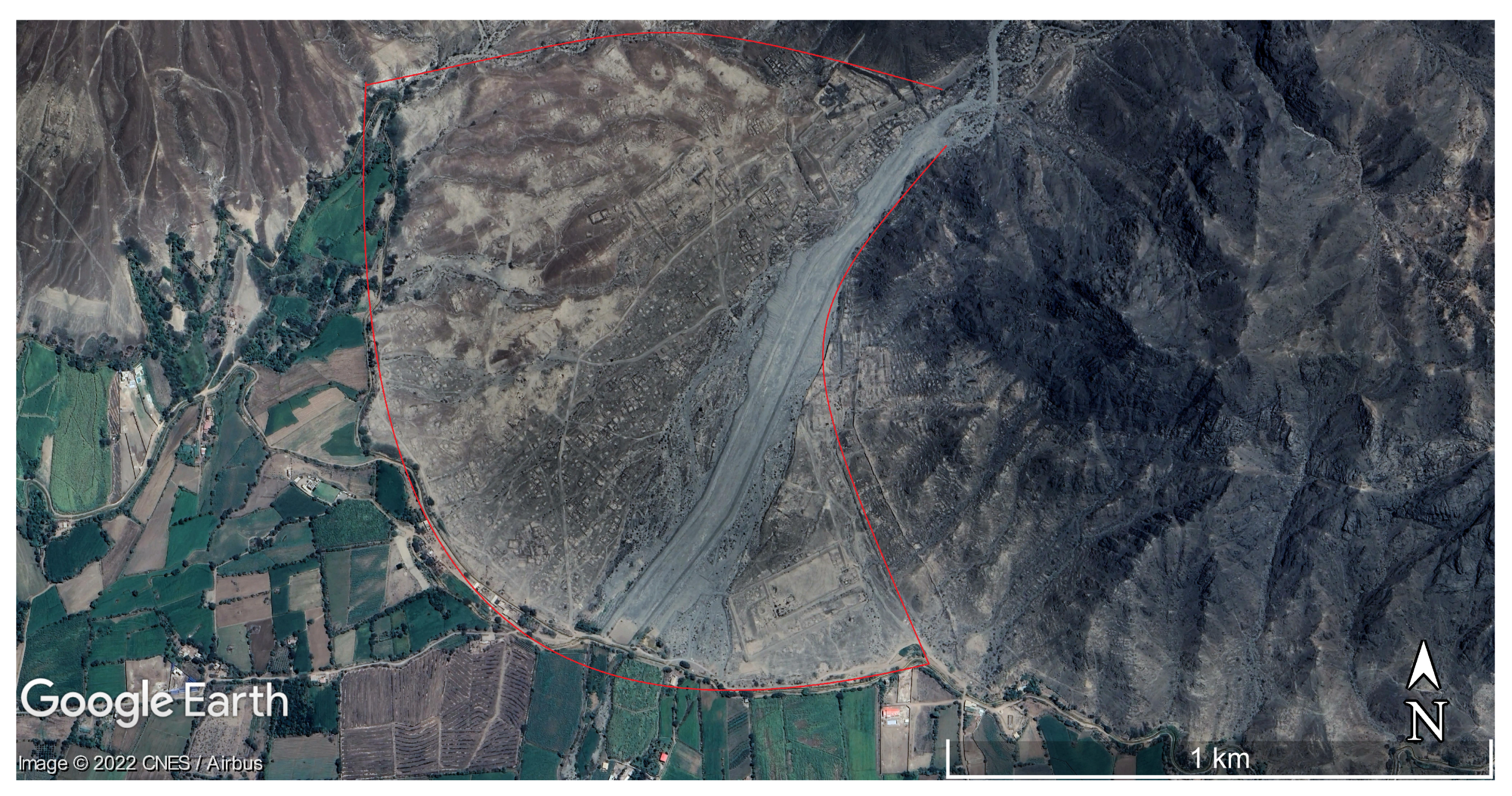
5.2. Huacas de Moche (Lower Moche Valley)
The settlement of Huacas de Moche is an early capital of the Moche state. It is located in the lower Moche Valley and includes the well-known buildings named Huaca del Sol and Huaca de la Luna (Figure 2). In their pioneering works, Nials et al. (a) [14] report “the discovery of an El Niño catastrophe of a magnitude far greater and more devastating than all other such natural disasters striking the coast since the conquistadors first arrived in 1532. Transpiring about 1100 A.D., this prehistoric Niño was of unprecedented magnitude, and the devastation it wrought taxes the imagination of geologists and archaeologists alike”. Since about 1000 CE, the Chimu culture had completely transformed the desert landscape, building a complicated system of reclamation channels over an area of tens of square kilometers. According to the authors (who have surveyed hundreds of kilometers of ancient waterways), all the channels experienced massive erosion and dropped from use before the beginning of the successive sub-cultural phase (a few tens of years later). This allowed an approximate dating of the hydrogeomorphic disaster, which was consequently called the Chimu Flood. Later, much of the reclaimed area would revert to desert in short time. However, the lack of absolute dating makes this reconstruction questionable.
The water level of the Chimu Flood would be still recognizable on the western side of the adobe brick pyramid Huaca del Sol (see Figure 7 on page 12 of Nials et al. (a) [14]), marked by a notch about 10–15 m above the present Rio Moche level. However, according to the geomorphological reconstruction of the authors, the major landscape change happened at the middle Moche Valley, 5–10 km upstream Huaca del Sol, with the lowering of the alluvial plain due to erosion estimated in ca. 5 m [15] (see Section 5.3). Moreover, the authors stated that “a very conservative estimate would be flood waters at least 2 to 4 times the size of the 1925[/1926] floods, the worst in the last 400 years” [15].
Several works selected from Scopus and WoS databases by the method described in Section 3 cite the works of the research group of Nials. Craig and Shimada [16] hint at a possible regional correlation with the slack-water deposit they found along the Rio La Leche Valley (see Section 5.1), thus laying the groundwork for the conceptualization of an 11th century El Niño event. Wells [17] suggests the possible coincidence of the Chimu Flood with the so-called Naymlap Flood, an ethno-historically recorded hydrological disaster associated with the name of a cultural hero [7,132]. Again, Wells and Noller [88] use the Chimu Flood to explicate the recurrence interval of the “Mega” El Niños in northern coastal Peru. Finally, Van Buren [91], Nesbitt [120], Huckleberry et al. [113], and Caramanica et al. [126] cite Nials et al. [14,15], simply to describe the destructive effects of the major El Niño events on the ancient irrigation systems and the consequences on the human communities. None of these studies deals with the reliability of the reconstruction provided by Nials et al. [14,15].
By archaeological excavations on Huaca de la Luna, Uceda and Canziani Amico [86] argued for the occurrence of moderate El Niño events before the Chimu Flood. They interpreted three layers of sediment with remnants of painted washed-off walls, found on successive floors of the temple, as evidence of intense precipitation and runoff processes, the most recent dated around 600 CE. This latter should have produced significant flow within the braided streams of the Moche Valley without, however, causing either changes in the landscape or the abandonment of the settlement as asserted by Moseley and Richardson [83]. Instead, according to these authors, between 500 and 600 CE, “flood water brought by El Niño struck the Moche capital, they leveled much of the city, stripping as much as 15 feet” (about 4.6 m) “off some areas. It is unclear if the magnitude of destruction reflects more than one El Niño events, perhaps exacerbated by an earthquake. The survivors rebuilt their city only to see it gradually inundated by sand dunes that swept inland after forming on the beach at the mouth of the Moche River”. It is apparent how the interpretation of geoarchaeological data coming from the same site can even lead to conflicting hypotheses [128]. Thus, the impact of the El Niño event around 600 CE on settlement and landscape at Huacas de Moche must be further investigated, especially with the aim of filling possible gaps in knowledge and addressing the above question.
The study by Prieto et al. [133] on a mass-sacrifice event discovered at a site of the lower Moche Valley, in addition to reporting a possible landscape process due to an El Niño event dated between 1400 and 1450 CE, is a remarkable example of the indissoluble connection between geological and archaeological data in the late pre-Hispanic coastal Peru. According to these authors, “stratigraphic evidences suggests that the sacrifice was made following a heavy rain/flood that deposited a layer of mud on top of the clean sand in which the children and camelids were buried”. The conspicuous number of 14C dated samples ensures a high reliability of the chronological attribution.
5.3. Caballo Muerto and Quebrada de los Chinos (Middle Moche Valley)
Caballo Muerto Archaeological Complex and Quebrada de los Chinos are located in the middle valley of Rio Moche (Figure 1). The first includes the building named Huaca Cortada, from which data on the effects of El Niño events on settlement and landscape have recently been collected by Nesbitt [120]. According to this author, the whole archaeological complex “is situated within an environment susceptible to El Niño flooding”. Due to its geomorphological setting, especially the alluvial fan located 10.5 km north-east of Huacas de Moche (Figure 3) may preserve significant geoarchaeological proxies.
Archaeological excavations at Huaca Cortada documented the occurrence of four El Niño events throughout the second half of the second millennium BCE. The identified El Niño proxies are laminated muddy layers deposited from runoff water. They contain thin laminas of white paint, which formed as the rain washed off the painted, plastered surfaces of the temple walls. These layers are sandwiched between pre- and post-event structures and were exposed to weathering for a short time, as inferred from their sedimentological features. By the 14C method, a date of 1600–1450 BCE is established for the earliest El Niño proxy of Huaca Cortada. The age of the subsequent events lies between 1100 and 900 BCE, as inferred from pottery finds. Finally, it must be noted that, as Caballo Muerto is surrounded by quebradas, changes in the shape of the braided streams for each event may be supposed, which would be significant modifications for a desert environment. Such a question should be addressed with geological studies. Nevertheless, according to Nesbitt [120], the communities of the Initial Period were able to rapidly reconstruct and enlarge buildings, and thus “the social, religious and economic mechanisms that allowed for the mobilisation of labour […] were not negatively impacted by El Niño”.
The geoarchaeological record of the middle Moche Valley preserves a frequent recurrence of El Niño also for the two millennia of the Common Era. Huckleberry and Billman [92] describe 13 ENSO-related flood and debris flow deposits beneath the present floodplain surface of Quebrada de los Chinos, which are younger than 2000 cal y BP. The findings of these authors seem to confirm the inference by Nials et al. [15] on apparent fluvial landscape changes due to severe precipitations (see Section 5.2), and reflect the late Holocene increases in El Niño activity [10,55]. With reference to methodological issues, the authors underline the need for a correct correlation between the geological characteristics of the deposits and the causative climatic events to make strong hypotheses [92].
5.4. Casma and Cerro Sechin (Lower Casma Valley)
With reference to radiocarbon dating, Wells [17,82] analysed in detail the alluvial terraces system, which characterizes the lower Rio Casma Valley (Figure 1). The system presents three floodplain surfaces whose ages of formation are between 3000 and 200 cal y BP (see Table 1 and Figure 4 of Reference [17], pp. 1135–1136), thus suggesting significant geomorphological changes during the late pre-Hispanic time driven by river sediment transport and tectonic uplift. These results are consistent with data on the beach ridge accretion of the Pampas Las Salinas [79,80], about 50 km northwest of the Rio Casma mouth. From a geological point of view, such a landscape dynamics is not surprising for valleys and coasts of the Peruvian desert. Late Pleistocene and Lower Holocene were, for example, earlier periods throughout which El Niños severely impacted coastal Peru, leaving signatures on ancient landscapes (see, e.g., References [19,85,93]).
Thirteen flood deposits younger than 3.2 ka are recorded along the stratigraphic section of Wells [17,82], six of which were deposited before the conquistadors first arrived in 1532. The upper two and the lower two of these latter are 14C dated by means of incorporated organic material. The author, however, does not recognize the ca. 1100 event (i.e., The Chimu Flood) defined by Nials et al. [14] in the Moche Valley (see Section 5.2). She focus mainly on the recurrence of the hydrogeomorphic events rather than their strength and suggests, for the considered time interval, the increase in frequency of flooding and the occurrence of an event “much larger than that which occurred during 1982–1983” at least once every 1000 years. This hypothesis can be explained as follows: (a) the Mega El Niño events [19,80] actually exist and cause flood disasters in coastal Peru and possibly extreme climatic anomalies worldwide; or (b) the rainfall associated with the El Niño event is distributed such that extraordinary floods occur near Casma once every 1000 years [17]. Clearly, this question is crucial for the topic treated in the review.
Complementary evidence on the paleoflood record of the Casma district can be provided by archaeological data from Cerro Sechin site (Figure 1). However, only one laminated mud deposit ascribed to runoff water has been archaeologically dated (see Samaniego et al. [78]) and may be correlated to a terraced alluvial deposit 14C dated at 1200 BCE by Wells [82]. Likely, new geoarchaeological research in this area would help in providing significant data on landscape change due to El Niño events.
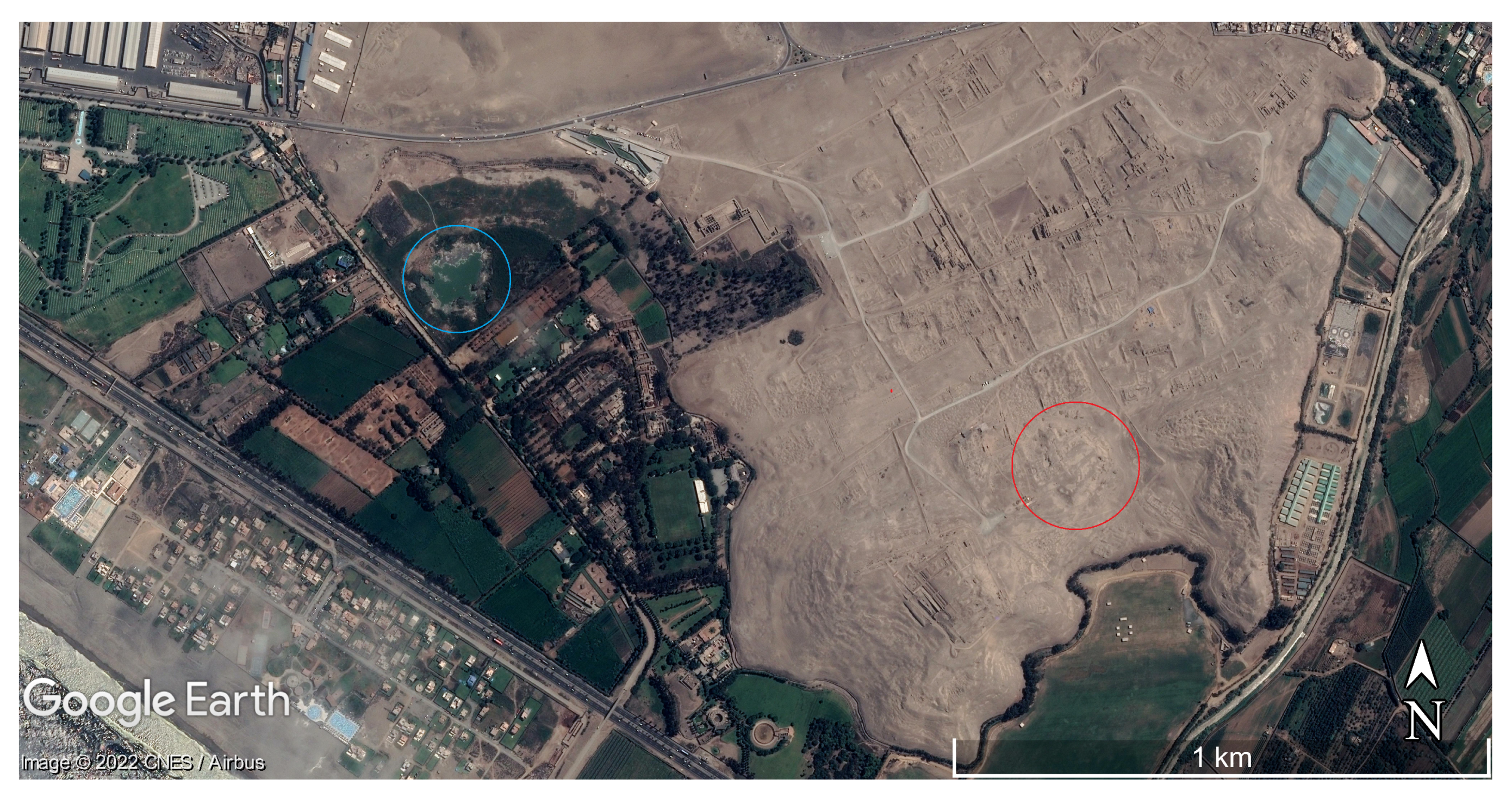
5.5. Old Temple of Pachacamac and Urpi Kocha Lagoon (Lower Lurin Valley)
According to Franco and Paredes, the Old Temple of Pachacamac (Figure 4) was abandoned around 600 CE due to heavy rains that washed away and damaged the adobe walls of the building while runoff water deposited around thick layers of mud [90]. These authors argue that an unusual climate event triggered temple modifications and led to the development of new social trends and the introduction of architectural elements from the Andes Highlands. Later, Franco stated “there is no doubt that the rains that caused this event correspond to a Mega Niño” [134], which is now referred to also as the 6th-century El Niño event. The sedimentological and palynological study by Winsborough et al. on the near Urpi Kocha Lagoon (located 0.4 km west of Pachacamac) confirms such a suggestion [23]. These last authors found, in cores extracted from the bottom of the pool, evidence of three major floods associated with El Niño events in late pre-Hispanic time, the middle event dated between 436 and 651 CE (see Table 5 of Winsborough et al. [23], p. 611).
The El Niño signature left at Pachacamac as recognized and interpreted by Franco and Paredes [90] is similar to the ones described by Samaniego et al. [78] and Wells [82] at Cerro Sechin (see Section 5.4) and by Nesbitt [120] at Caballo Muerto (see Section 5.3), respectively. It is apparent that, in late pre-Hispanic settlements, El Niño events may have left traces in the geoarchaeological record likely corresponding to landscape changes. Nevertheless, as carried out from further archaeological excavation, the adobe constructions of Pachacamac were seriously affected by repeated torrential rains up to the twentieth century, and especially by the 1925/1926 El Niño event [135]. The erosive processes caused by these rains have partially erased the traces of the most ancient events, making the reconstruction of the paleoflood record at the lower Lurin Valley more difficult.
The validity of the hypothesis that one, or even two, El Niño events affected the central coastal Peru around 600 CE is confirmed by the findings of Mauricio [136] at Huaca 20 site (Maranga archaeological complex, lower Rimac Valley, 30 km north-west of Pachacamac). Within such a site, now incorporated into the southern suburbs of Lima, the author describes two destructive floods separated by a phase of reconstruction during the Middle Horizon (14C dated between 550 and 690 CE). Despite the limited size of the site, several geoarchaeological sections showing the above sequence are reported as basic data.
Other areas in the lower Lurin Valley offer opportunities for future research on the relationships between landscape modifications and El Niño events in the Initial Period and Early Horizon. Archaeological studies at the sites of Mina Perdida (5 km north-east of Pachacamac) and Manchay Bajo (10 km north-east of Pachacamac) have revealed the existence of debris flow, flood, and slack-water deposits in the respective geoarchaeological record [137,138]. A number of 14C dating on organic remains extracted from the stratigraphic successions provide chronological references for the El Niño signatures.
5.6. Pampa de Palpa (Valleys of Rio Ica and Rio Grande)
The pampa southwest of Palpa (Figure 1) constitutes the northern margin of the Atacama desert, and was inhabited by several cultures during the pre-Hispanic times. It has been the object of different studies on the development of loess deposits, paleosoils, and alluvial terraces that provide insights about the long-term relationship between climate processes and desert landscape changes [4,101,106,118]. Moreover, this hyper-arid region includes relevant sites of interest for the present review and is next to the ceremonial center of Cahuachi (which will be discussed separately in Section 5.7).
Located at the lower valley of Rio Ica, the Samaca fluvial plain (Figure 1) is currently a riparian oasis that hosts numerous archaeological and paleobotanic remains. The latter are mainly constituted by partially fossilized trunks of the phreatophyte Prosopis, as established by Beresford-Jones et al. [103,104]. The geomorphological, archaeological, and paleoenvironmental evidence gathered by these authors allows them to state the occurrence of a major El Niño event “at some time toward the end of the Early Intermediate Period, which spread a deep fluvial layer across the upper Samaca Basin, caused the river to cut some 5 m down into its floodplain and had catastrophic effects upon [a] canal system” [103]. Such a result is consistent with the conclusions of other studies made in northern and central Peru [23,84,86]. However, it explicates part of the above landscape modification, as well as of the decline in the settlement. In fact, according to [103,104,109], human-induced gradual destruction of the Prosopis forest in pre-Hispanic time would have considerably increased the exposure to the flood hazard of landscape and settlement, making them more vulnerable to severe events. The deforestation process would culminate during the Middle Horizon, causing the final abandonment of the settlement [104].
Later, large urban settlements developed in the Late Intermediate Period (1000–1400 CE) within the pampa of Palpa, the most prominent example of what is the so-called Ciudad Perdida de Huayuri that, according to Hanzalova and Pavelka [117], was destroyed by an El Niño event. However, no indications or evidence of such an episode were found in other articles identified by citation database queries (Section 4, Table 3 and Table 4). It must be observed that Eitel and their colleagues [4,106] posit an abandonment of such a “lost city” as a consequence of the depletion of water reserve, likely related to a climate change. The above questionable information in Ref. [117] may be due to a gap in the knowledge in the literature.
5.7. Cahuachi Ceremonial Center (Middle Nazca Valley)
According to Grodzicki [21,139], the archaeological site of Cahuachi (Figure 5) was affected by three catastrophic floods caused by El Niño between 2100 and 1000 BP. These studies support the major landscape changes ascribed to El Niño events in late pre-Hispanic time for the whole coastal desert of Peru. The second event would have even caused the collapse of the Nasca Culture (around 600 CE), while the third completely buried the ceremonial center [20,21]. In support of their hypothesis, the author describes conglomerate deposits that would result from deposition of exceptionally large, fluid debris flows. Finally, the landscape of Cahuachi would have been re-shaped (and the monumental building unearthed) throughout the last millennium. A necessary assumption for this argument is that abandonment and burial of the ceremonial center preceded the construction of the Nazca Lines [20]. However, such geoglyphs, created on the desert pavement by removing colored pebbles and leaving the underlying reg soil exposed, are mainly dated from 400 BCE to 600 CE [140,141,142,143].
Dealing with the second catastrophic flood inferred by Grodzicki [139], Silverman [6] observes that around 600 CE “Cahuachi had ceased to function as the great early Nasca ceremonial center”. In their review on the occurrence of El Niño events, Machare and Ortlieb [56] consider the hydrogeomorphic events posited in References [20,21] no more than possible local climate change indicators. Nevertheless, the main question on the reliability of the Grodzicki’s hypothesis comes from the research group headed by Eitel and Machtle [4,101,106]. Starting from the observation of “the good state of preservation of geoglyphs, even where they cross valleys or erosion rills”, such authors “disagree with ideas that catastrophic El Niño events destroyed the Nasca Civilization” [4]. Again, as a result of extensive field surveys, they remark how the integrity “of the line exemplarily illustrates that the valley floor has never been flooded since the Nasca period. Only a small channel in the foreground provides evidence for weak episodic runoff events during the past two millennia” [106]. Finally, these authors also extend their conclusion to the contiguous pampa of Palpa (see Section 5.6).
To further test the consistency of the hypothesis of Grodzicki, stratigraphic and petrographic analyses of upper bedrock and surficial cover of the ceremonial center were carried out by Delle Rose et al. [26]. The results of this study show that the conglomerate deposits interpreted by Grodzicki as signatures of El Niño events, belonging instead to the Tertiary–Quaternary clastic succession that forms the regional substratum. Moreover, such coarse-size sediments are a source of pebbles and cobbles, which form the desert pavement. The inconsistency of Grodzicki’s hypothesis was likely due to knowledge gap in geological stratigraphy [26].
Recent archaeological excavations on Templo Sur have shed new light on hydrogeomorphic events that damaged the adobe brick buildings at Cahuachi during the development of the Nasca Culture. In fact, the inferences of Orefici [144] about two torrential rains that partially destroyed roof and walls of the temple next to the end of the fourth century CE, a time with no El Niño events reported in the reviewed literature, lead us to reconsider both the climatic pattern responsible for the events and the type of Earth surface response expected for the coastal desert. It must be noted that samples gathered at Cantalloc (20 km east of Cahuachi) by Pavelka et al. [122], considered by these authors remains of an ancient flood, are 14C dated between 47 and 480 CE.
5.8. Moquegua Valley and Quebrada Miraflores
Geoarchaeological studies throughout Moquegua Valley and surrounding areas [22,24,51,84] were mainly aimed to argue the relationships between El Niño events and human responses rather than possible landscape processes [91]. Nevertheless, data exposed in the reviewed works allow one to argue for abrupt geomorphological changes to the desert environment. As a matter of fact, already thirty years ago, Moseley et al. [84] stated that “serious landscape modification should indicate extreme ENSO conditions or ancient ‘Mega-Niño’ phenomena”.
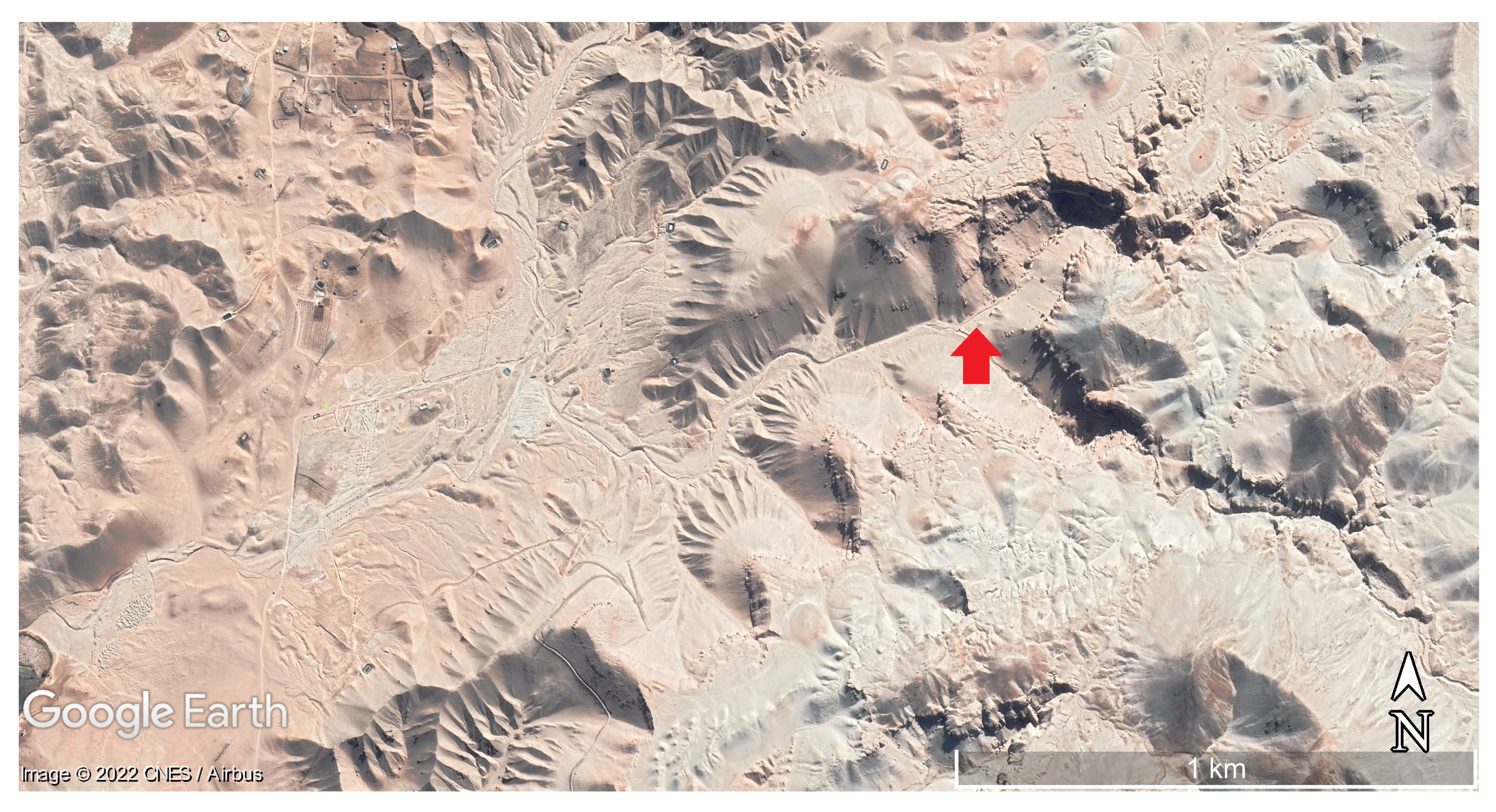
Three main depositional units confidently ascribed to El Niño events have been identified and dated by the authors. Two of them have a late pre-Hispanic age, while the third (named Chuza Unit) is dated at 1607–1608 CE [96]. The oldest 14C dated unit (730–690 CE) is formed by debris flow deposits (identified within the dry Rio Muerto sub-basin [24] (see Figure 6)), and flood deposits recognized elsewhere [51]. As it signaled fast and extensive regolith mobilization, this unit constitutes evidence of a singular hydrogeomorphic event. For what concerns the regolith production, in a highly seismic region such as coastal Peru, it is increased by the shattering of the landscape during the frequent earthquakes that produce pervasive ground cracking and microfracturing of hill-slope materials [84,96].
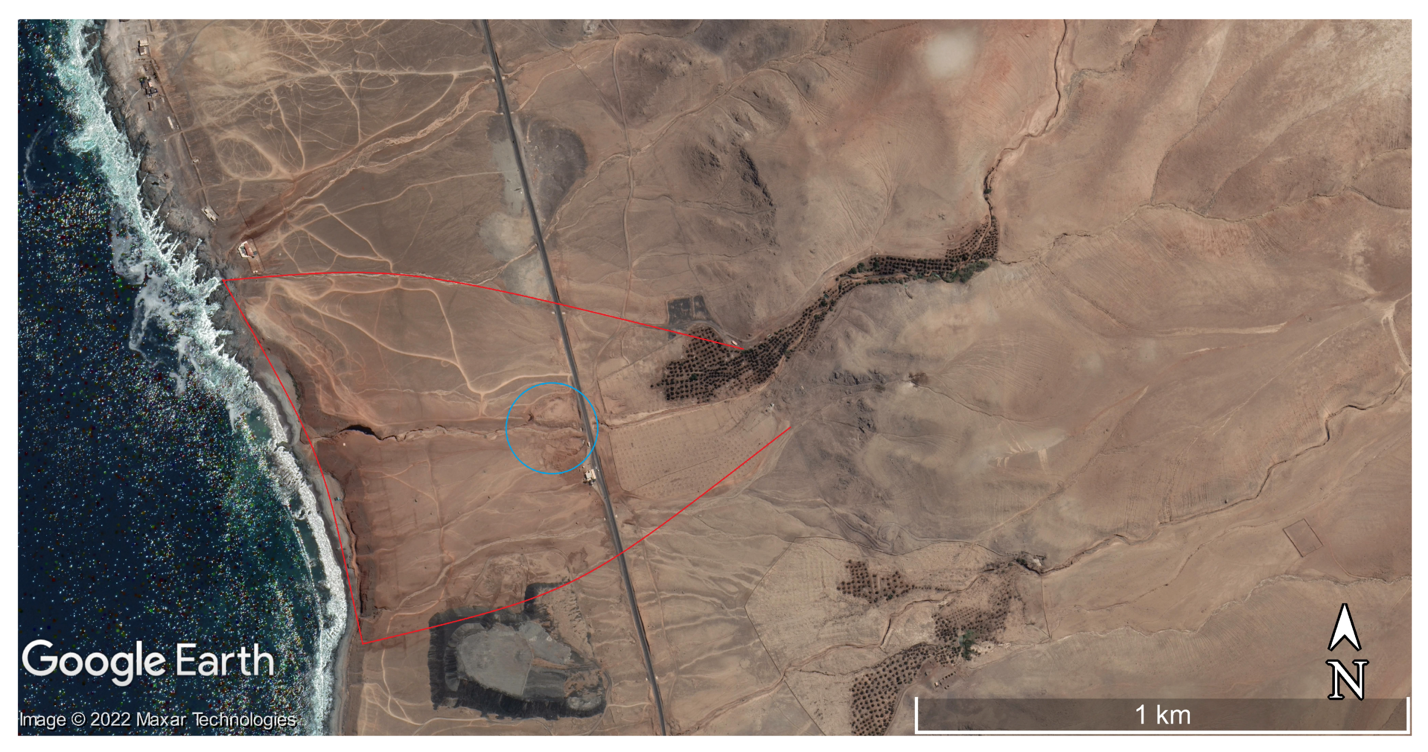
The second depositional unit of interest for this review is a horizon marker referred to as the Miraflores Flood event [84]. It is formed by debris flow deposits and flood deposits indirectly dated between 1350 and 1370 CE by ice core data of the Quelccaya Ice Cap [22,145,146]. Such an age is confirmed by radiocarbon dates of samples taken at Rio Muerto [51] (Figure 6). At Quebrada Miraflores (Figure 7), the thickness of the marker reaches 1.2 m, which is a higher order of magnitude compared with any other flood deposits preserved in the geological record, including the Chuza Unit.
Figure 7.
Quebrada Miraflores; 2021 satellite image (1725′49″–1726′36″ S, 7122′22″–7121′42″ W). The extent of the Miraflores Unit according to Satterlee et al. [22] is marked by a red line and the location of Chiribaya settlement by a blue circle (see text).
Figure 7.
Quebrada Miraflores; 2021 satellite image (1725′49″–1726′36″ S, 7122′22″–7121′42″ W). The extent of the Miraflores Unit according to Satterlee et al. [22] is marked by a red line and the location of Chiribaya settlement by a blue circle (see text).

In this last area, mobilized sediments spread laterally out of the braided streams and up the ravine walls before descending to the sea across the coastal plain. Large clasts and boulders with a diameter of up to 3 m were also moved across the coastal plain by the Miraflores Flood [22]. Such a hydrogeomorphic event would also be implicated in the collapse or decline of the Chiribaya culture [111,147]. The imprint on the Peruvian desert surface of this 14th-century El Niño event is confirmed by zooarchaeological research. Rubinatto et al. posit “that the abundance of anuran remains” they found in Rio Muerto area may be related to the Miraflores Flood, since “this event generated increased rainfall in the desert, creating conditions favorable for frogs and toads” [130]. However, for a critical examination of such a hypothesis, these authors exhort further paleoenvironmental and zooarchaeological studies. In any case, the potential of Miraflores Unit as a horizon marker should be fully exploited in landscape reconstruction.
5.9. Discussion Summary
Landscape processes confidently ascribed to El Niño events are chronologically summarized in Table 5. They are considered responsible for changes in late pre-Hispanic coastal Peru to varying degrees.
The above chronology may be tentatively compared with paleo El Niño proxies. By analyzing a high resolution marine sediment record about 60 km west of Lima, Rein et al. [148] argued maximum of El Niño activity during the third and second millennium BP, while El Niño events would have been persistently weak during the Medieval Climate Anomaly (MCA, ca. 900–1300 CE). Yan et al. [149], computing SOI (Section 2) from different precipitation proxy records in Pacific Ocean, found negative index during MCA, which indicates general El Niño-dominated conditions. However, such differences in climatic reconstructions may reflect the geographic complexities of the Pacific coastal regions [45]. As a matter of fact, SOI calculated for the Galapagos Islands (850 km off the coast of Ecuador) shows positive values during MCA in contrast with the ones of the western Pacific [149]. The oxygen isotopes ratio (18O) of ice core record from Quelccaya ice cap is depleted in 18O between 1100 and 1300 CE, thus highlighting a warming trend over the Andes [150]. Such a finding is consistent with low El Niño activity during MCA [148,151]. Consequently, the hydrogeomorphic events that can be attributed to El Niño with the lowest uncertainties should be those that precede or follow the MCA.
As a result of the WoS and Scopus data mining and the subsequent full-text analysis, the first evaluable hydrogeomorphic signature is located at Caballo Muerto and 14C-dated at about 3.5 ka BP [120]. However, it is in advance of the beginning of ENSO’s modern periodicity (Section 2). Three more recent deposits dated around 3.0 ka and ascribed to El Niño events were also reported by this author (Table 5). To date, the magnitude of landscape response to these events along the middle Moche Valley is not yet investigated, while the only identified surface process is mud deposition from runoff over archaeological structures (Section 5.3). Moreover, the lower Lurin Valley also preserves geoarchaeological proxies [137,138] that can help shed light on the landscape modifications that occurred around the transition from the second to the first millennia BCE.
Around 1200 BCE, Casma Valley was affected by torrential rains, and thus, related proxies are preserved in both alluvial terrace sequences [82] and archaeological records of Cerro Sechin [78]. The hypothesis that both signatures were produced by the same El Niño event should be verified by further research (Section 5.4). According to Wells [17], the alluvial terrace system of the Casma Valley contains 13 flood deposits ascribable to late Holocene El Niños. Four 14C-dated events occurred in pre-Hispanic time, but unfortunately, no date fits well with events identified in other basins or sites (Table 5). In contrast, one or more events transpiring about 600 CE have hit the valleys of Rio Moche (Huacas del Sol), Rio Lurin (Pachacamac), and Rio Ica (Samaca) (Section 5.2, Section 5.5 and Section 5.6). Such evidence has led some authors to speak of a 6th-century Mega El Niño (see, e.g., [21,23,134]).
Nevertheless, the recognition of one or more events to the transition from the first to the second millennium CE at some sites of north-central coastal Peru (Table 5) has strengthened the paradigm of the 11th-century Mega El Niño (see, e.g., [21,56,152]). The seminal reconstruction of the Chimu Flood by Nials et al. [14,15] has greatly influenced the literature, but it should be tested by further research, and the related deposits should be absolute-dated. Furthermore, the age of the ethno-historical Naymlap Flood remains unclear [84,132]. It ranges from around 1000 CE (see, e.g., [16,23]) to around 1350 CE (see, e.g., [17,153,154]). As a matter of fact, Naymlap Flood “may refer to different floods in different valleys at different times during the Late Intermediate Period” [7].
If on the one hand, El Niño events had catastrophic consequences associated with floodplain stripping, irrigation system damage, and settlement destruction, on the other hand, they also provided cultural opportunities, triggered technological innovation, strengthened community resilience against hydrogeomorphological events, and played important roles in replenishing and maintaining groundwater resources throughout the coastal desert [51,88,138]. Nevertheless, extensive human intervention (desert reclamation, Prosopis deforestation) has likely caused some variations in landscape response, also increasing exposure to extreme events of settlements and infrastructures (Section 5.2 and Section 5.6).
Authors have deeply investigated the landscape response and destructive effects of the Miraflores Flood, the last hydrogeomorphic event ascribed to a “Mega” El Niño in pre-Hispanic times [22,24,51,84,111,147] (Section 5.8). With the arrival of Spanish conquistadors, the production of historical documents begins, so the sources of knowledge on El Niño events are enriched with a fundamental element [34,56,81,155]. However, it is only with the systematic observations of the warm ocean current running along the central Pacific coast of South America (El Niño in its initial meaning, see Section 2) that all the necessary criteria to assess El Niño events are available.
A final consideration must be made on the limitation of the above finding due to the use of WoS and Scopus. Papers published in journals not indexed in these citation databases are obviously excluded. Moreover, as remarked upon in Section 3, documents written in English are favored over those written in other languages in data mining from WoS and Scopus [68]. Such problems may have partially affected this review. However, in the discussion on the main study areas (Section 5),documents written in Spanish and published in (not WoS- and/or Scopus-indexed) Peruvian journals and books ([131,134,135,136]) were also used, to the best of the author’s knowledge. Clearly, the result may be hereafter improved and updated. On the other hand, data mining from other databases, systematic reading of papers written in Spanish and published in Peruvian journals, and the use of web search engines such as Google Scholar could be goals of future investigations.
6. Conclusions
Landscape modifications ascribed to El Niño events in late pre-Hispanic coastal Peru were mined and summarized by processing comprehensive databases (Section 3). Then, a review of the selected documents was performed in accordance with dependable guidelines (Section 4). The examination of the reliability of data contained in the reviewed documents allowed us to identify some critical questions in the treated topic and suggest several research goals (Section 5). The El Niño proxies discussed provide incomplete and heterogeneous paleoflood records for coastal Peru. The current state of geoarchaeological knowledge is not enough to define the temporal and spatial trend of the landscape effects of El Niño events during the late pre-Hispanic time. However, it gives some essential milestones (Section 5.9, Table 5).
Several landscape processes ascribable to El Niño events have been recognized by authors (Table 5). The less impressive one, mud deposition from runoff, has, however, sometimes been identified in archaeological sites, thus allowing valuable chronological attributions (Section 5.3 and Section 5.5). Slack-water deposits found along the valleys of Rio La Leche and Rio Jequetepeque (Section 5.1), as well as other flood sediments recognized along the valleys of Rio Casma and Rio Samaca (Section 5.4 and Section 5.6), and at the sites Huacas de Moche and Batan Grande (Section 5.1 and Section 5.2), could have great potential in landscape reconstruction. The activation of debris flows has been recognized throughout Jequetepeque Valley (Section 5.1), Moche Valley (Section 5.3), Moquegua Valley, and the surrounding areas (Section 5.8). Within the catchment of Rio Muerto, regolith denudation and mobilization have shown a great size and extent (Section 5.8). The Miraflores Unit resulted in one of the major landscape changes for the whole coastal Peru, which was also involved in the end of the Chiribaya culture. It is apparently the better investigated proxy record confidently ascribed to an El Niño event (Section 5.8, Table 5).
Throughout the review, some possible research goals were highlighted that might be helpful in overcoming critical questions. They do not claim to be all-inclusive and are reported (not in the order of importance) in what follows: (a) to increase the number of the absolute dating of selected geoarchaeological records (see, e.g., the case of the deposits related to the Chimu Flood in the lower Moche Valley, Section 5.2); (b) to analyze stratigraphic successions that should preserve different proxies (see, e.g., the case of the alluvial fan within the Caballo Muerto Archaeological Complex, Section 5.3); (c) to investigate the landscape response of El Niño signatures discovered in archaeological sites (see the cases of Huaca Cortada and Cerro Sechin discussed in Section 5.3 and Section 5.4, respectively); (d) to test the consistency of literature hypothesis with methods of various disciplines (see, e.g., the paleoecological and zooarchaeological study performed in the Rio Muerto catchment, Section 5.8); (e) to extract data from other databases also including documents written in Spanish and published in Peruvian journals (Section 5.9).
Funding
This research received no external funding.
Acknowledgments
I wish to thank G. Orefici, (the Centro de Estudios Arqueológicos Precolombinos (Peru)), for hospitality and valuable advice during research campaigns of 2012 and 2019 in Cahuachi.
Conflicts of Interest
The author declares no conflict of interest.
Appendix A. Works Excluded from the Discussion by Full-Text Analysis
As explained in Section 4, 20 documents selected from database search were not discussed in Section 5 because they were not appropriate for the review’s purpose (Table A1).

Table A1.
Works whose full text was analyzed with no data useful for the objective of the review.
| Reference | Main Issue |
|---|---|
| [1] | Geomorphological effects of 1982/83 and 1997/98 El Niños |
| [61] | Morpho-pedological characterization of a Western Andean offshoot |
| [87] | Early-middle Holocene human-nature relationships |
| [95] | Late Quaternary evolution of a stretch of the Ecuador coast |
| [97] | Ancient peoples ability to mitigate El Niño effects |
| [98] | Debris flow burial episode of a Late Pleistocene site |
| [99] | Late pre-Hispanic desert reclamation and El Niño effects mitigation |
| [100] | Development of desert soil under ENSO conditions |
| [50] | Reliability of agricultural practices to face El Niño negative effects |
| [105] | Early-middle Holocene occupation history of a costal site |
| [107] | Introduction on methods and technologies in geoarchaeology |
| [108] | Geomorphological effects of El Niño on Western Andean Slope |
| [110] | Late Quaternary evolution of an Amazon Basin sector |
| [116] | Characterization of late Holocene coastal upwelling in Peru |
| [119,125] | El Niño influences on settlement pattern of a Western Andean offshoot |
| [121] | Paleobotanical analysis aimed to explore ancient desert reclamation |
| [123] | Reconstruction of the paleo-evolution of a coastal lagoon |
| [124] | Biological crusts effects on reg soil evolution |
| [127] | Late Quaternary environmental history of a Western Andean offshoot |
References
- Mettier, R.; Schlunegger, F.; Schneider, H.; Rieke-Zapp, D.; Schwab, M. Relationships between landscape morphology, climate and surface erosion in northern Peru at 5° S latitude. Int. J. Earth Sci. 2009, 98, 2009–2022. [Google Scholar] [CrossRef] [Green Version]
- Morera, S.B.; Condom, T.; Crave, A.; Steer, P.; Guyot, J.L. The impact of extreme El Niño events on modern sediment transport along the western Peruvian Andes (1968–2012). Sci. Rep. 2017, 7, 11947. [Google Scholar] [CrossRef] [Green Version]
- Rodriguez-Morata, C.; Ballesteros-Canovas, J.A.; Rohrer, M.; Espinoza, J.C.; Beniston, M.; Stoffel, M. Linking atmospheric circulation patterns with hydro-geomorphic disasters in Peru. Int. J. Climatol. 2018, 38, 3388–3404. [Google Scholar] [CrossRef]
- Eitel, B.; Hecht, S.; Mächtle, B.; Schukraft, G.; Kadereit, A.; Wagner, G.A.; Kromer, B.; Unkel, I.; Reindel, M. Geoarchaeological evidence from desert loess in the Nazca–Palpa region, Southern Peru: Palaeoenvironmental changes and their impact on Pre-Columbian cultures. Archaeometry 2005, 47, 137–158. [Google Scholar] [CrossRef]
- Jordan, T.E.; Kirk-Lawlor, N.E.; Blanco, N.P.; Rech, J.A.; Cosentino, N.J. Landscape modification in response to repeated onset of hyperarid paleoclimate states since 14 Ma, Atacama Desert, Chile. Geol. Soc. Amer. Bull. 2014, 126, 1016–1046. [Google Scholar] [CrossRef]
- Silverman, H.; Proulx, D.A. The Nasca; Blackwell Publishers: Malden, MA, USA, 2002. [Google Scholar]
- Huckleberry, G.; Caramanica, A.; Quilter, J. Dating the Ascope Canal System: Competition for Water during the Late Intermediate Period in the Chicama Valley, North Coast of Peru. J. Field Archaeol. 2018, 31, 17–30. [Google Scholar] [CrossRef] [Green Version]
- Ortlieb, L.; Vargas, G. Debris-flow deposits and El Niño impacts along the hyperarid southern Peru coast. In El Niño in Peru: Biology and Culture over 10,000 Years; Haas, J., Dillon, M.O., Eds.; Field Museum of Natural History: Chicago, IL, USA, 2003; pp. 24–51. [Google Scholar]
- Vargas, G.; Rutllant, J.; Ortlieb, L. ENSO tropical–extratropical climate teleconnections and mechanisms for Holocene debris flows along the hyperarid coast of western South America (17°–24° S). Earth Planet. Sci. Lett. 2006, 249, 467–483. [Google Scholar] [CrossRef]
- Rein, B. How do the 1982/83 and 1997/98 El Niños rank in a geological record from Peru? Quat. Int. 2007, 161, 56–66. [Google Scholar] [CrossRef]
- Aceituno, P.; Prieto, M.D.R.; Solari, M.E.; Martinez, A.; Poveda, G.; Falvey, M. The 1877–1878 El Niño episode: Associated impacts in South America. Clim. Chang. 2009, 92, 389–416. [Google Scholar] [CrossRef] [Green Version]
- Murga, J.C. Permanecer tras el desastre: La ciudad de Saña después de los Niños de 1578 y 1720. Archaeobios 2010, 4, 85–95. (In Spanish) [Google Scholar]
- Sandweiss, D.H.; Andrus, C.F.T.; Kelley, A.R.; Maasch, K.A.; Reitz, E.J.; Roscoe, P.B. Archaeological climate proxies and the complexities of reconstructing Holocene El Niño in coastal Peru. Proc. Natl. Acad. Sci. USA 2020, 117, 201912242. [Google Scholar] [CrossRef]
- Nials, F.L.; Deeds, E.E.; Moseley, M.E.; Pozorski, S.E.; Pozorski, T.G.; Feldman, R. El Niño: The catastrophic flooding of coastal Peru. Field Museum Nat. Inst. Bull. 1979, 50, 4–14. [Google Scholar]
- Nials, F.L.; Deeds, E.E.; Moseley, M.E.; Pozorski, S.E.; Pozorski, T.G.; Feldman, R. El Niño: The catastrophic flooding of coastal Peru. Part II. Field Museum Nat. Inst. Bull. 1979, 50, 4–10. [Google Scholar]
- Craig, A.K.; Shimada, I. El Niño flood deposits at Batan Grande, northern Peru. Geoarchaeology 1986, 1, 29–38. [Google Scholar] [CrossRef]
- Wells, L.E. Holocene history of the El Niño phenomenon as recorded in flood sediments of northern coastal Peru. Geology 1990, 18, 1134–1137. [Google Scholar] [CrossRef]
- Paredes, P.; Ramos, J. Evidencias arqueologicas del “Niño” en las excavaciones de Pachacamac. In Paleo ENSO Records; Ortlieb, L., Machare, J., Eds.; Orstom-Concytec: Lima, Peru, 1992; pp. 225–233. (In Spanish) [Google Scholar]
- Mörner, N.A. Present El Niño-ENSO events and past super-ENSO events. Bull. Inst. Fr. Études Andines 1993, 22, 3–12. [Google Scholar] [CrossRef]
- Grodzicki, J. Los geoglifos de Nazca segun algunos datos geologicos. In Paleo ENSO Records; Ortlieb, L., Machare, J., Eds.; Orstom-Concytec: Lima, Peru, 1992; pp. 119–130. (In Spanish) [Google Scholar]
- Grodzicki, J. Nasca: Los Sintomas Geológicos del Fenómeno El Niño y Sus Aspectos Arquelógicos; Warsaw University: Warsaw, Poland, 1994. (In Spanish) [Google Scholar]
- Satterlee, D.R.; Moseley, M.E.; Keefer, D.K.; Tapia, J.E.A. The Miraflores El Niño disaster: Convergent catastrophes and prehistoric agrarian change in southern Peru. Andean Past 2000, 6, 95–116. [Google Scholar]
- Winsborough, B.M.; Shimada, I.; Newsom, L.A.; Jones, J.G.; Segura, R.A. Paleoenvironmental catastrophies on the Peruvian coast revealed in lagoon sediment cores from Pachacamac. J. Archaeol. Sci. 2012, 39, 602–614. [Google Scholar] [CrossRef]
- Magilligan, F.J.; Goldstein, P.S. El Niño floods and culture change: A late Holocene flood history for the Rio Moquegua, southern Peru. Geology 2001, 29, 431–434. [Google Scholar] [CrossRef]
- Silverman, H. Ancient Nasca Settlement and Society; University of Iowa Press: Iowa City, IA, USA, 2002. [Google Scholar]
- Delle Rose, M.; Mattioli, M.; Capuano, N.; Renzulli, A. Stratigraphy, Petrography and Grain-Size Distribution of Sedimentary Lithologies at Cahuachi (South Peru): ENSO-Related Deposits or a Common Regional Succession? Geosciences 2019, 9, 80. [Google Scholar] [CrossRef] [Green Version]
- Moy, C.M.; Seltzer, G.O.; Rodbell, D.T.; Anderson, D.M. Variability of El Niño/Southern Oscillation activity at millennial timescales during the Holocene epoch. Nature 2002, 420, 162–164. [Google Scholar] [CrossRef]
- Licciardi, J.M.; Schaefer, J.M.; Taggart, J.R.; Lund, D.C. Holocene glacier fluctuations in the Peruvian Andes indicate northern climate linkages. Science 2009, 325, 1677–1679. [Google Scholar] [CrossRef] [Green Version]
- Meyer, I.; Wagner, S. The Little Ice Age in Southern South America: Proxy and Model Based Evidence. In Past Climate Variability in South America and Surrounding Regions. Developments in Paleoenvironmental Research; Vimeux, F., Sylvestre, F., Khodri, M., Eds.; Springer: Dordrecht, The Netherlands, 2009; Volume 14, pp. 395–412. [Google Scholar]
- Moher, D.; Liberati, A.; Tetzlaff, J.; Altman, D.G.; PRISMA Group. Preferred reporting items for systematic reviews and meta-analyses: The PRISMA statement. Biomed. J. 2009, 339, b2535. [Google Scholar]
- Page, M.J.; McKenzie, J.E.; Bossuyt, P.M.; Boutron, I.; Hoffmann, T.C.; Mulrow, C.D.; Shamseer, L.; Tetzlaff, J.M.; Akl, E.A.; Brennan, S.E.; et al. The PRISMA 2020 statement: An updated guideline for reporting systematic reviews. Biomed. J. 2021, 372, 71. [Google Scholar]
- Satyamurty, P.; Nobre, C.; Silva Dias, P.L. South America. In Meteorology of the Southern Hemisphere; Monograph Series No. 27; Karoly, D.J., Vincent, D., Eds.; American Meteorological Society: Boston, MA, USA, 1998; pp. 119–140. [Google Scholar]
- Rundel, P.; Villagra, P.E.; Dillon, M.; Roig-Juñent, S.; Debandi, G. Arid and Semi-Arid Ecosystems. In The Physical Geography of South America; Veblen, T.T., Young, K., Orme, A., Eds.; Oxford University Press: Oxford, UK, 2007; pp. 158–183. [Google Scholar]
- Quinn, W.H.; Neal, V.T.; Antunez De Mayolo, S.E. El Niño occurrences over the past four and a half centuries. J. Geophys. Res. 1987, 92, 14449–14461. [Google Scholar] [CrossRef]
- Sanabria, J.; Bourrel, L.; Dewitte, B.; Frappart, F.; Rau, P.; Solis, O.; Labat, D. Rainfall along the coast of Peru during strong El Niño events. Int. J. Climatol. 2017, 38, 1737–1747. [Google Scholar] [CrossRef]
- Rodriguez-Morata, C.; Diaz, H.F.; Ballesteros-Canovas, J.A.; Rohrer, M.; Stoffel, M. The anomalous 2017 coastal El Niño event in Peru. Clim. Dyn. 2019, 52, 5605–5622. [Google Scholar] [CrossRef]
- Son, R.; Wang, S.Y.S.; Tseng, W.L.; Barreto Schuler, C.W.; Becker, E.; Yoon, J.H. Climate diagnostics of the extreme floods in Peru during early 2017. Clim. Dyn. 2020, 54, 935–945. [Google Scholar] [CrossRef] [Green Version]
- Trenberth, K.E. The definition of El Niño. Bull. Am. Meteorol. Soc. 1997, 78, 2771–2777. [Google Scholar] [CrossRef]
- Trenberth, K.E.; Caron, J.M. The Southern Oscillation revisited: Sea level pressure, surface temperatures, and precipitations. J. Clim. 2000, 13, 4358–4365. [Google Scholar] [CrossRef]
- Jadhav, J.; Panickal, S.; Marathe, S.; Ashok, K. On the possible cause of distinct El Niño types in the recent decades. Sci. Rep. 2015, 5, 17009. [Google Scholar] [CrossRef] [Green Version]
- Hu, Z.Z.; Huang, B.; Zhu, J.; Kumar, A.; McPhaden, M.J. On the variety of coastal El Niño events. Clim. Dyn. 2019, 52, 7537–7552. [Google Scholar] [CrossRef]
- Wang, C.; Deser, C.; Yu, J.Y.; DiNezio, P.; Clement, A. El Niño and Southern Oscillation (ENSO): A review. In Coral Reefs of the Eastern Pacific; Glymm, P., Manzello, D., Enochs, I., Eds.; Springer: Berlin/Heidelberg, Germany, 2017; pp. 85–106. [Google Scholar]
- Lin, J.; Qian, T. A New Picture of the Global Impacts of El Nino-Southern Oscillation. Sci. Rep. 2019, 9, 17543. [Google Scholar] [CrossRef] [Green Version]
- Sandweiss, D.H.; Richardson, J.B.; Reitz, E.J.; Rollins, H.B.; Maasch, K.A. Geoarchaeological evidence from Peru for a 5000 year B.P. onset of El Nino. Science 1996, 273, 1531–1533. [Google Scholar] [CrossRef]
- Cobb, K.M.; Westphal, N.; Sayani, H.R.; Watson, J.T.; Di Lorenzo, E.; Cheng, H.; Edwards, R.L.; Charles, C.D. Highly variable El Niño-Southern Oscillation throughout the Holocene. Science 2013, 339, 67–70. [Google Scholar] [CrossRef] [Green Version]
- Waylen, P.R.; Caviedes, C.N. El Niño and annual floods in coastal Peru. In Catastrophic Flooding; Mayer, L., Nash, D., Eds.; Allen and Unwin: Boston, MA, USA, 1987; pp. 57–78. [Google Scholar]
- Tapley, T.D.; Waylen, P.R. Spatial variability of annual precipitation and ENSO events in western Peru. Hydrol. Sci. J. 1990, 35, 429–446. [Google Scholar] [CrossRef]
- Bird, B.; Abbott, M.B.; Vuille, M.; Rodbell, D.T.; Stansell, N.D.; Rosenmeier, M.F. A 2300-year-long annually resolved record of the South American summer monsoon from the Peruvian Andes. Proc. Natl. Acad. Sci. USA 2011, 108, 8583–8588. [Google Scholar] [CrossRef] [Green Version]
- Giraldez, L.; Silva, Y.; Zubieta, R.; Sulca, J. Change of the Rainfall Seasonality Over Central Peruvian Andes: Onset, End, Duration and Its Relationship With Large-Scale Atmospheric Circulation. Climate 2020, 8, 23. [Google Scholar] [CrossRef] [Green Version]
- Manners, R.B.; Magilligan, F.J.; Goldstein, P.S. Floodplain Development, El Niño, and Cultural Consequences in a Hyperarid Andean Environment. Ann. Am. Assoc. Geogr. 2007, 97, 229–249. [Google Scholar] [CrossRef]
- Magilligan, F.J.; Goldstein, P.S.; Fisher, G.B.; Bostick, B.C.; Manners, R.B. Late Quaternary hydroclimatology of a hyper-arid Andean watershed: Climate change, floods, and hydrologic responses to the El Niño-Southern Oscillation in the Atacama Desert. Geomorphology 2008, 101, 14–32. [Google Scholar] [CrossRef]
- Hanley, D.E.; Bourassa, M.A.; O’Brien, J.J.; Smith, S.R.; Spade, E.R. A Quantitative Evaluation of ENSO Indices. J. Clim. 2003, 16, 1249–1258. [Google Scholar] [CrossRef]
- Khalil, A.F.; Kwon, H.H.; Lall, U.; Miranda, M.J.; Skees, J. El Niño–Southern Oscillation–based index insurance for floods: Statistical risk analyses and application to Peru. Water Resour. Res. 2007, 43, W10416. [Google Scholar] [CrossRef]
- Wang, Z.; Wu, D.; Chen, X.; Qiao, R. ENSO indices and analyses. Adv. Atmos. Sci. 2013, 30, 1491–1506. [Google Scholar] [CrossRef]
- Sandweiss, D.H.; Maasch, K.A.; Burger, R.L.; Richardson, J.B.; Rollins, H.B.; Clement, A. Variation in Holocene El Niño frequencies: Climate records and cultural consequences in ancient Peru. Geology 2001, 29, 603–606. [Google Scholar] [CrossRef]
- Machare, J.; Ortlieb, L. Registros del fenomeno El Niño en el Perù. Bull. Inst. Fr. Études Andines 1993, 22, 35–52. (In Spanish) [Google Scholar] [CrossRef]
- Río Chicama Bloquea Panamericana Norte. (In Spanish). Available online: https://www.elperuano.pe/noticia/53379-rio-chicama-bloquea-panamericana-norte (accessed on 16 November 2022).
- Osterkamp, W.R.; Friedman, J.M. The disparity between extreme rainfall events and rare floods—With emphasis on the semi-arid American West. Hydrol. Process. 2000, 14, 2817–2829. [Google Scholar] [CrossRef]
- Tooth, S.; Nanson, G.C. Equilibrium and nonequilibrium conditions in dryland rivers. Phys. Geogr. 2000, 21, 183–211. [Google Scholar] [CrossRef]
- Matmon, A.; Simhai, O.; Amit, R.; Haviv, I.; Porat, N.; Mcdonald, E.; Benedetti, L.; Finkel, R. Desert pavement-coated surfaces in extreme deserts present the longest-lived landforms on Earth. Geol. Soc. Amer. Bull. 2009, 121, 688–697. [Google Scholar] [CrossRef] [Green Version]
- Calderoni, G.; Lazzarotto, L.; Rodolfi, G.; Terribile, F. Evolution of the coastal reliefs of southern Peru (Lomas) as suggested by the soil-landform relationships: A case study from Mejìa site (Department of Arequipa). Geogr. Fis. Din. Quat. 2002, 25, 23–43. [Google Scholar]
- Sparavigna, A.C. Peruvian Transverse Dunes in the Google Earth Images. Philica 2014, 474, hal-01389724f. Available online: https://hal.archives-ouvertes.fr/hal-01389724/document (accessed on 14 October 2022).
- Delle Rose, M. The geology of Cahuachi. In Ancient Nasca World. New Insights from Science and Archaeology; Lasaponara, R., Masini, N., Orefici, G., Eds.; Springer: Basel, Switzerland, 2016; pp. 47–64. [Google Scholar]
- Magirl, C.S.; Griffiths, P.G.; Webb, R.H. Analyzing debris flows with the statistically calibrated empirical model LAHARZ in southeastern Arizona, USA. Geomorphology 2010, 119, 111–124. [Google Scholar] [CrossRef]
- Aguilar, G.; Cabre, A.; Fredes, V.; Villela, B. Erosion after an extreme storm event in an arid fluvial system of the southern Atacama Desert: An assessment of the magnitude, return time, and conditioning factors of erosion and debris flow generation. Nat. Hazards Earth Syst. Sci. 2020, 20, 1247–1265. [Google Scholar] [CrossRef]
- Kochel, R.C.; Baker, V.R. Paleoflood hydrology. Science 1982, 215, 353–361. [Google Scholar] [CrossRef]
- Salisbury, L. Web of Science and Scopus: A Comparative Review of Content and Searching Capabilities. Charlest. Advis. 2009, 11, 5–18. [Google Scholar]
- Mongeon, P.; Paul-Hus, A. The journal coverage of Web of Science and Scopus: A comparative analysis. Scientometrics 2016, 106, 213–228. [Google Scholar] [CrossRef]
- Pranckute, R. Web of Science (WoS) and Scopus: The Titans of Bibliographic Information in Today’s Academic World. Publications 2021, 9, 12. [Google Scholar] [CrossRef]
- Frodeman, R. Geological reasoning: Geology as an interpretive and historical science. Geol. Soc. Am. Bull. 1995, 107, 960–968. [Google Scholar] [CrossRef]
- Dott, R.H. What is unique about geological reasoning? Geol. Soc. Am. Today 1998, 10, 15–18. [Google Scholar]
- Raab, T.; Frodeman, R. What is it like to be a geologist? A phenomenology of geology and its epistemological implications. Philos. Geogr. 2002, 5, 69–81. [Google Scholar] [CrossRef]
- Hodder, I. Interpretative archaeology and its role. Am. Antiq. 1991, 56, 7–18. [Google Scholar] [CrossRef]
- Fogelin, L. Inference to the Best Explanation: A Common and Effective Form of Archaeological Reasoning. Am. Antiq. 2007, 72, 603–625. [Google Scholar] [CrossRef]
- Lucas, G. Interpretation in Archaeological Theory. In Encyclopedia of Global Archaeology; Smith, C., Ed.; Springer: New York, NY, USA, 2014; pp. 4013–4022. [Google Scholar]
- Butzer, K.W. Challenges for a cross-disciplinary geoarchaeology: The intersection between environmental history and geomorphology. Geomorphology 2008, 101, 402–411. [Google Scholar] [CrossRef]
- Hill, C.L.; Rapp, G. Geoarchaeology. In Encyclopedia of Global Archaeology; Smith, C., Ed.; Springer: New York, NY, USA, 2014; pp. 3008–3017. [Google Scholar]
- Samaniego, L.; Vergara, E.; Bischof, H. New evidence on Cerro Sechin, Casma Valley, Peru. In Early Ceremonial Architecture in the Andes; Donnan, C.B., Ed.; Dumbarton Oaks Research Library and Collection: Washington, DC, USA, 1985; pp. 165–190. [Google Scholar]
- Sandweiss, D.H. The beach ridges at Santa, Peru: El Niño, uplift, and prehistory. Geoarchaeology 1986, 1, 17–28. [Google Scholar] [CrossRef]
- Rollins, H.B.; Richardson, J.B.; Sandweiss, D.H. The birth of El Niño: Geoarchaeological evidence and implications. Geoarchaeology 1986, 1, 3–15. [Google Scholar] [CrossRef]
- DeVries, T.J. A review of geological evidence for ancient El Niño activity in Peru. J. Geophys. Res. 1987, 92, 471–479. [Google Scholar] [CrossRef]
- Wells, L.E. An alluvial record of El Niño events from northern coastal Peru. J. Geophys. Res. 1987, 92, 14463–14470. [Google Scholar] [CrossRef]
- Moseley, M.; Richardson, J.B. Doomed by natural disaster. Archaeology 1992, 45, 44–45. [Google Scholar]
- Moseley, M.; Tapia, J.; Satterlee, D.S.; Richardson, J.B. Flood events, El Niño events, and tectonic events. In Paleo ENSO Records; Ortlieb, L., Machare, J., Eds.; Orstom-Concytec: Lima, Peru, 1992; pp. 207–212. (In Spanish) [Google Scholar]
- Ortlieb, L.; Machare, J. Former El Niño events: Records from western South America. Glob. Planet. Chang. 1993, 7, 181–202. [Google Scholar] [CrossRef]
- Uceda, C.S.; Canziani Amico, J. Evidencias de grandes precipitaciones en diversas etapas constructivas de la Huaca de la Luna, costa norte del Perú. Bull. Inst. Fr. Études Andines 1993, 22, 313–343. [Google Scholar]
- Keefer, D.; Moseley, M.; Richardson, J.; Satterlee, D.; Day Lewis, A. Early Maritime Economy and El Niño Events at Quebrada Tacahuay, Peru. Science 1998, 281, 1833–1835. [Google Scholar] [CrossRef] [PubMed]
- Wells, L.E.; Noller, J.S. Holocene coevolution of the physical landscape and human settlement in northern coastal Peru. Geoarchaeology 1999, 14, 755–789. [Google Scholar] [CrossRef]
- Veit, H. Klima- und Landschaftswandel in der Atacama. Geographische Rundschau 2000, 52, 4–9. (In German) [Google Scholar]
- Franco, R.; Paredes, P. El Templo Viejo de Pachacamac: Nuevos aportes al studio del Horizonte Medio. Bol. Arqueol. PUCP 2000, 4, 607–630. (In Spanish) [Google Scholar]
- Van Buren, M. The archaeology of El Niño events and others “natural” disasters. J. Archaeol. Method Theory 2001, 8, 129–149. [Google Scholar] [CrossRef]
- Huckleberry, G.; Billman, B.R. Geoarchaeological insights gained from surficial geologic mapping, middle Moche Valley, Peru. Geoarchaeology 2003, 18, 505–521. [Google Scholar] [CrossRef]
- Keefer, D.K.; Moseley, M.E.; deFrance, S.D. A 38,000-year record of floods and debris flows in the Ilo region of southern Peru and its relation to El Niño events and great earthquakes. Palaeogeogr. Palaeoclimatol. Palaeoecol. 2003, 194, 41–77. [Google Scholar] [CrossRef]
- Dillehay, T.; Kolata, A.L.; Pino, M.Q. Pre-industrial human and environment interactions in northern Peru during the late Holocene. Holocene 2004, 14, 272–281. [Google Scholar] [CrossRef]
- Federici, P.R.; Rodolfi, G. Geomorphological Features and Evolution of the Ensenada de Atacames (Provincia de Esmeraldas, Ecuador). J. Coast. Res. 2004, 20, 700–708. [Google Scholar] [CrossRef]
- Keefer, D.K.; Moseley, M.E. Southern Peru desert shattered by the great 2001 earthquake: Implications for paleoseismic and paleo-El Niño-Southern Oscillation records. Proc. Natl. Acad. Sci. USA 2004, 101, 10878–10883. [Google Scholar] [CrossRef] [Green Version]
- Brooks, W.E.; Willett, J.C.; Kent, J.D.; Vasquez, V.; Rosales, T. The Muralla Pircada: An ancient Andean debris flow retention dam, Santa Rita B archaeological site, Chao Valley, northern Peru. Landslides 2005, 2, 117–123. [Google Scholar] [CrossRef]
- deFrance, S.D.; Keefer, D.K. Quebrada Tacahuay, Southern Peru: A Late Pleistocene Site Preserved by a Debris Flow. J. Field Archaeol. 2005, 30, 385–399. [Google Scholar] [CrossRef]
- Zaro, G.; Alvarez, A.U. Late Chiribaya agriculture and risk management along the arid Andean coast of southern Perú, A.D. 1200–1400. Geoarchaeology 2005, 20, 717–737. [Google Scholar] [CrossRef]
- Fabre, A.; Gauquelin, T.; Vilasante, F.; Ortega, A.; Puig, H. Phosphorus content in five representative landscape units of the Lomas de Arequipa (Atacama Desert-Peru). Catena 2006, 65, 80–86. [Google Scholar] [CrossRef]
- Machtle, B.; Eitel, B.; Kadereit, A.; Unkel, I. Holocene environmental changes in the northern Atacama desert, southern Peru (14°30′S) and their impact on the rise and fall of Pre-Columbian cultures. Z. Geomorphol. Suppl. 2006, 142, 47–62. [Google Scholar]
- Andrus, C.F.T.; Sandweiss, D.H.; Reitz, E.J. Climate Change and Archaeology: The Holocene History Of El Niño On The Coast Of Peru. In Case Studies in Environmental Archaeology. Interdisciplinary Contributions to Archaeology; Reitz, E.J., Scudder, S.J., Scarry, C.M., Eds.; Springer: New York, NY, USA, 2008; pp. 143–157. [Google Scholar]
- Beresford-Jones, D.G.; Arce Torres, S.; Whaley, O.Q.; Chepstow-Lusty, A.J. The role of Prosopis in ecological and landscape change in the Samaca Basin, lower Ica Valley, south coast Peru from the Early Horizon to the Late Intermediate Period. Latin Am. Antiqu. 2009, 20, 303–332. [Google Scholar] [CrossRef]
- Beresford-Jones, D.G.; Lewis, H.; Boreham, S. Linking cultural and environmental change in Peruvian prehistory: Geomorphological survey of the Samaca Basin, Lower Ica Valley, Peru. Catena 2009, 78, 234–249. [Google Scholar] [CrossRef]
- deFrance, S.D.; Grayson, N.; Wise, K. Documenting 12,000 Years of Coastal Occupation on the Osmore Littoral, Peru. J. Field Archaeol. 2009, 34, 227–246. [Google Scholar] [CrossRef]
- Eitel, B.; Machtle, B. Man and Environment in the Eastern Atacama Desert (Southern Peru): Holocene Climate Changes and Their Impact on Pre-Columbian Cultures. In New Technologies for Archaeology; Reindel, M., Wagner, G.A., Eds.; Springer: Berlin/Heidelberg, Germany, 2009; pp. 17–37. [Google Scholar]
- Reindel, M.; Wagner, G.A. Introduction—New Methods and Technologies of Natural Sciences for Archaeological Investigations in Nasca and Palpa, Peru. In New Technologies for Archaeology; Reindel, M., Wagner, G.A., Eds.; Springer: Berlin/Heidelberg, Germany, 2009; pp. 1–13. [Google Scholar]
- Abbuhl, L.M.; Norton, K.P.; Schlunegger, F.; Kracht, O.; Aldahan, A.; Possnert, G. El Niño forcing on 10Be-based surface denudation rates in the northwestern Peruvian Andes? Geomorphology 2010, 123, 257–268. [Google Scholar] [CrossRef]
- Beresford-Jones, D.G. The Lost Woodlands of Ancient Nasca: A Case-Study in Ecological and Cultural Collapse; Oxford University Press: Oxford, UK, 2011; pp. 1–208. [Google Scholar]
- Bernal, C.; Christophoul, F.; Darrozes, J.; Soula, J.C.; Baby, P.; Burgos, J. Late Glacial and Holocene avulsions of the Rio Pastaza Megafan (Ecuador–Peru): Frequency and controlling factors. Int. J. Earth. Sci. 2011, 100, 1759–1782. [Google Scholar] [CrossRef] [Green Version]
- Goldstein, P.S.; Magilligan, F.J. Hazard, risk and agrarian adaptations in a hyperarid watershed: El Niño floods, streambank erosion, and the cultural bounds of vulnerability in the Andean Middle Horizon. Catena 2011, 85, 155–167. [Google Scholar] [CrossRef]
- Gayo, E.M.; Latorre, C.; Jordan, T.E.; Nester, P.L.; Estay, S.; Ojeda, K.F.; Santoro, C.M. Late Quaternary hydrological and ecological changes in the hyperarid core of the northern Atacama Desert (21° S). Earth Sci. Rev. 2012, 113, 120–140. [Google Scholar] [CrossRef]
- Huckleberry, G.; Hayashida, F.; Johnson, J. New Insights into the Evolution of an Intervalley Prehistoric Irrigation Canal System, North Coastal Peru. Geoarchaeology 2012, 27, 492–520. [Google Scholar] [CrossRef]
- Sandweiss, D.H.; Kelley, A.R. Archaeological Contributions to Climate Change Research: The Archaeological Record as a Paleoclimatic and Paleoenvironmental Archive. Annu. Rev. Anthropol. 2012, 41, 371–391. [Google Scholar] [CrossRef]
- Sandweiss, D.H.; Quilter, J. Collation, Correlation, and Causation in the Prehistory of Coastal Peru. In Sudden Environmental Change: Answers From Archaeology; Cooper, J., Sheets, P., Eds.; University Press of Colorado: Boulder, CO, USA, 2012; pp. 117–141. [Google Scholar]
- Etayo-Cadavid, M.F.; Andrus, C.F.T.; Jones, K.B.; Hodgins, G.W.L.; Sandweiss, D.H.; Uceda-Castillo, S.; Quilter, Q. Marine radiocarbon reservoir age variation in Donax obesulus shells from northern Peru: Late Holocene evidence for extended El Niño. Geology 2013, 41, 599–602. [Google Scholar] [CrossRef]
- Hanzalova, K.; Pavelka, K. Documentation and virtual reconstruction of historical objects in Peru damaged by an earthquake and climatic events. Adv. Geosci. 2013, 35, 67–71. [Google Scholar] [CrossRef]
- Machtle, B.; Eitel, B. Fragile landscapes, fragile civilizations—How climate determined societies in the pre-Columbian south Peruvian Andes. Catena 2013, 103, 62–73. [Google Scholar] [CrossRef]
- Kalicki, P.; Kalicki, T.; Kittel, P. The Influence of El Niño on Settlement Patterns in Lomas de Lachay, Central Coast, Peru. Interdiscip. Archaeol. 2014, 5, 147–160. [Google Scholar] [CrossRef]
- Nesbitt, J. El Niño and second-millennium BC monument building at Huaca Cortada (Moche Valley, Peru). Antiquity 2016, 351, 638–653. [Google Scholar] [CrossRef]
- Caramanica, A.; Koons, M.L. Living on the edge. Pre-Columbian habitation of the desert periphery of the Chicama valley, Perú. In The Archaeology of Human-Environment Interactions: Strategies for Investigating Anthropogenic Landscapes, Dynamic Environments, and Climate Change in the Human Past; Contreras, D., Ed.; Routledge: London, UK, 2016; pp. 141–164. [Google Scholar]
- Pavelka, K.; Matouskova, E.; Faltynova, M. Dating of Artefacts from Nasca Region and Falsification of “Mandala” Geoglyph. In Proceedings of the 16th International Multidisciplinary Scientific GeoConference SGEM, Albena, Bulgaria, 30 June–6 July 2016; Volume 1, pp. 165–172. [Google Scholar]
- Christol, A.; Wuscher, P.; Goepfert, N.; Mogollon, V.; Bearez, P.; Gutierrez, B.; Carre, M. The Las Salinas palaeo-lagoon in the Sechura Desert (Peru): Evolution during the last two millennia. Holocene 2017, 27, 26–38. [Google Scholar] [CrossRef]
- Wang, F.; Michalski, G.; Luo, H.; Caffee, M. Role of biological soil crusts in affecting soil evolution and salt geochemistry in hyper-arid Atacama Desert, Chile. Geoderma 2017, 307, 54–64. [Google Scholar] [CrossRef]
- Kalicki, P.; Kalicki, T.; Kittel, P. Fog, mountain and desert: Human-environment interactions in Lomas de Lachay, Peru. In People in the Mountains; Pelisiak, A., Nowak, M., Astalos, C., Eds.; Archaeopress Publishing: Oxford, UK, 2018; pp. 207–223. [Google Scholar]
- Caramanica, A.; Huaman, L.H.; Morales, C.R.; Huckleberry, G.; Castillo, L.J.; Quilter, J. El Niño resilience farming on the north coast of Peru. Proc. Natl. Acad. Sci. USA 2020, 117, 24127–24137. [Google Scholar] [CrossRef] [PubMed]
- Kalicki, T.; Kalicki, P. Fluvial activity in the Lomas de Lachay during the upper Pleistocene and Holocene. Geomorphology 2020, 357, 107087. [Google Scholar] [CrossRef]
- Uceda, S.; Gayoso, H.; Castillo, F.; Rengifo, C. Climate and Social Changes: Reviewing the Equation with Data from the Huacas de Moche Archaeological Complex, Peru. Lat. Am. Antiq. 2021, 32, 705–722. [Google Scholar] [CrossRef]
- Sandweiss, D.H.; Maasch, K.A. Climatic and Cultural Transitions in Lambayeque, Peru, 600 to 1540 AD: Medieval Warm Period to the Spanish Conquest. Geosciences 2022, 12, 238. [Google Scholar] [CrossRef]
- Rubinatto Serrano, J.R.; Vallejo-Pareja, M.C.; deFrance, S.D.; Baitzel, S.I.; Goldstein, P.S. Contextual, Taphonomic, and Paleoecological Insights from Anurans on Tiwanaku Sites in Southern Peru. Quaternary 2022, 5, 16. [Google Scholar] [CrossRef]
- Castillo, L.J.; Christopher, B.D. Los mochicas del norte y los mochicas del sur: Una Perspectiva desde el Valle del Jequetepeque. In Vicus; Makowsky, K., Ed.; Banco de Crédito del Perú: Lima, Peru, 1994; pp. 142–181. (In Spanish) [Google Scholar]
- Rowe, J.H. Absolute chronology in the Andean area. Am. Antiq. 1945, 10, 265–284. [Google Scholar] [CrossRef]
- Prieto, G.; Verano, J.W.; Goepfert, N.; Kennett., D.; Quilter, J.; LeBlanc, S.; Fehren-Schmitz, L.; Forst, J.; Lund, M.; Dement, B.; et al. A mass sacrifice of children and camelids at the Huanchaquito-Las Llamas site, Moche Valley, Peru. PLoS ONE 2019, 14, e0211691. [Google Scholar] [CrossRef] [Green Version]
- Franco, R.G. Poder religioso, crisis y prosperidad en Pachacamac: Del Horizonte medio al intermedio tardío. Bull. Inst. Fr. Etudes Andines 2004, 33, 465–506. (In Spanish) [Google Scholar]
- Makowski, K. Pachacamac y la politica imperial Inca. In El Inca y la Huaca. La Religion del Poder y el Poder de la Religion en el Mundo Andino Antiguo; Curatola Petrocchi, M., Szeminski, J., Eds.; Pontificia Universidad Catolica del Peru: Lima, Peru, 2016; pp. 153–208. (In Spanish) [Google Scholar]
- Mauricio, A.C. Ecodinamicas Humanas en Huaca 20: Reevaluando el impacto de El Niño a finales del periodo Intermedio Temprano. Bol. Arqueol. PUCP 2014, 18, 159–190. (In Spanish) [Google Scholar]
- Burger, R.L.; Salazar-Burger, L. A Sacred Effigy from Mina Perdida and the Unseen Ceremonies of the Peruvian Formative. Res. Anthropol. Aesthet. 1998, 33, 28–53. [Google Scholar] [CrossRef]
- Burger, R.L. El Niño, early Peruvian civilization, and human agency: Some thoughts from the Lurin Valley. Fieldiana Bot. 2003, 43, 90–107. [Google Scholar]
- Grodzicki, J. Las catástrofes ecológicas en la Pampa de Nazca a fines del Holoceno y el fenómeno El Niño. In Proceedings of the El Fenómeno El Niño: A Través de las Fuentes Arqueológicas y Geológicas, Warsaw, Poland, 18–19 May 1990; pp. 64–102. (In Spanish). [Google Scholar]
- Silverman, H.; Browne, D. New Evidence for the Date of the Nazca Lines. Antiquity 1991, 65, 208–220. [Google Scholar] [CrossRef]
- Dorn, R.I.; Clarkson, P.B.; Nobbs, M.F.; Loendorf, L.L.; Whitley, D.S. New Approach to the Radiocarbon Dating of Rock Varnish, with Examples from Drylands. Ann. Am. Assoc. Geogr. 1992, 82, 136–151. [Google Scholar] [CrossRef]
- Rink, W.J.; Bartoll, J. Dating the geometric Nasca lines in the Peruvian desert. Antiquity 2004, 79, 390–401. [Google Scholar] [CrossRef] [Green Version]
- Stanish, C.; Tantalean, H.; Nigra, B.T.; Griffin, L. A 2300-year-old architectural and astronomical complex in the Chincha Valley, Peru. Proc. Natl. Acad. Sci. USA 2014, 111, 7218–7223. [Google Scholar] [CrossRef] [Green Version]
- Orefici, G. Recent discoveries in Cahuachi: The Templo Sur. In Ancient Nasca World. New Insights from Science and Archaeology; Lasaponara, R., Masini, N., Orefici, G., Eds.; Springer: Basel, Switzerland, 2016; pp. 363–374. [Google Scholar]
- Thompson, L.G.; Mosley-Thompson, E.; Morales Arnao, B. El Niño-Southern Oscillation Events Recorded in the Stratigraphy of the Tropical Quelccaya Ice Cap, Peru. Science 1984, 226, 50–53. [Google Scholar] [CrossRef] [Green Version]
- Thompson, L.G.; Mosley-Thompson, E.; Bolzan, J.F.; Koci, B.R. A 1500-year record of tropical precipitation in ice cores from the Quelccaya Ice Cap, Peru. Science 1985, 229, 971–973. [Google Scholar] [CrossRef]
- Reycraft, R.M. Long-term Human Response to El Niño in South Coastal Peru. In Environmental Disaster and the Archaeology of Human Response; Bawden, G., Reycraft, R.M., Eds.; Maxwell Museum of Anthropology: Albuquerque, NM, USA, 2000; pp. 99–119. [Google Scholar]
- Rein, B.; Luckge, A.; Reinhardt, L.; Sirocko, F.; Wolf, A.; Dullo, W.C. El Niño variability off Peru during the last 20,000 years. Paleoceanography 2005, 20, PA4003. [Google Scholar] [CrossRef]
- Yan, H.; Sun, L.; Wang, Y.; Huang, W.; Qiu, S.; Yang, C. A record of the Southern Oscillation Index for the past 2000 years from precipitation proxies. Nat. Geosci. 2011, 4, 611–614. [Google Scholar] [CrossRef]
- Thompson, L.; Mosley-Thompson, E.; Davis, M.; Zagorodnov, V.; Howat, I.; Mikhalenko, V.; Lin, P.N. Annually Resolved Ice Core Records of Tropical Climate Variability Over the Past 1800 Years. Science 2013, 340, 945–950. [Google Scholar] [CrossRef] [Green Version]
- Rein, B.; Luckge, A.; Sirocko, F. A major Holocene ENSO anomaly during the Medieval period. Geophys. Res. Lett. 2004, 31, L17211. [Google Scholar] [CrossRef]
- Shimada, I.; Wagner, U. Craft Production on the Pre-Hispanic North Coast of Peru: A Holistic Approach and its Results. In Archaeology as Anthropology: Theoretical and Methodological Approaches; Skibo, J., Grave, M., Stark, M., Eds.; University of Arizona Press: Tucson, AZ, USA, 2007; pp. 163–197. [Google Scholar]
- Kosok, P. Life, Land and Water in Ancient Peru; Long Island University Press: New York, NY, USA, 1965; 264p. [Google Scholar]
- Pozorski, T.; Pozorski, S. The Impact of the El Niño Phenomenon on Prehistoric Chimu Irrigation Systems of the Peruvian Coast. In El Niño in Peru: Biology and Culture Over 10,000 Years; Dillon, M.O., Haas, J., Eds.; Fieldiana, Botany New Series: Chicago, IL, USA, 2003; pp. 71–90. [Google Scholar]
- Ortlieb, L. The Documented Historical Record of El Niño Events in Peru: An Update of the Quinn Record (Sixteenth through Nineteenth Centuries). In El Niño and the Southern Oscillation: Multiscale Variability and Global and Regional Impacts; Diaz, H., Markgraf, V., Eds.; Cambridge University Press: Cambridge, UK, 2000; pp. 207–296. [Google Scholar]
Figure 1.
Main geographical regions of Peru. Numbers indicate the location of the cases discussed in the text; 1, Batan Grande; 2, Racarumi; 3, Caballo Muerto and Quebrada de los Chinos; 4, Huacas de Moche; 5, Casma and Cerro Sechin; 6, Pachacamac and Urpi Kocha; 7, Samaca; 8, Palpa; 9, Cahuachi; 10, Quebrada Miraflores; 11, Rio Muerto.
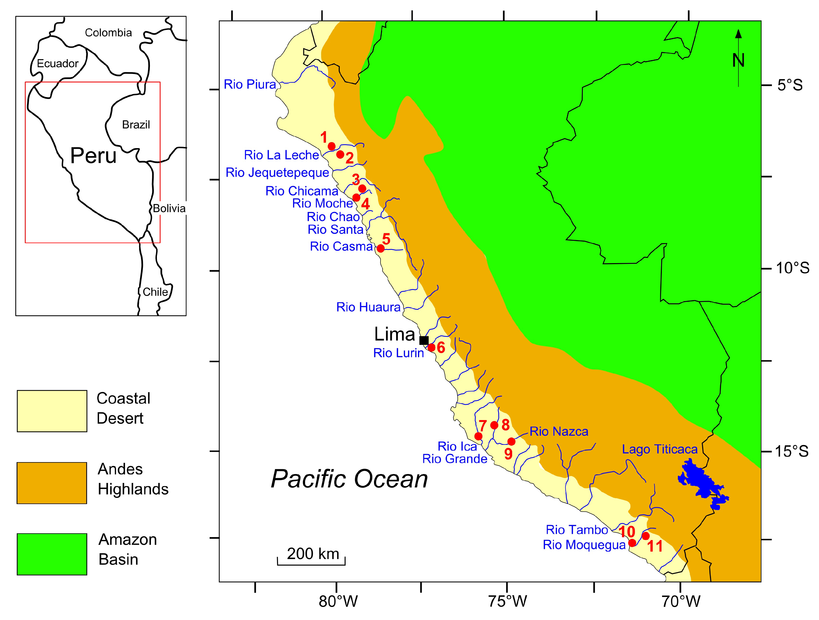
Figure 2.
Huacas de Moche; 2004 satellite image (807′25″–808′22″ S, 7900′17″–7858′35″ W). Huaca del Sol and Huaca de la Luna are marked by a red circle and blue circle, respectively. The depositional origin of late Holocene layers covering the plain between the monumental buildings should be ascertained, taking into account the landscape processes argued by the authors [14,83,128].
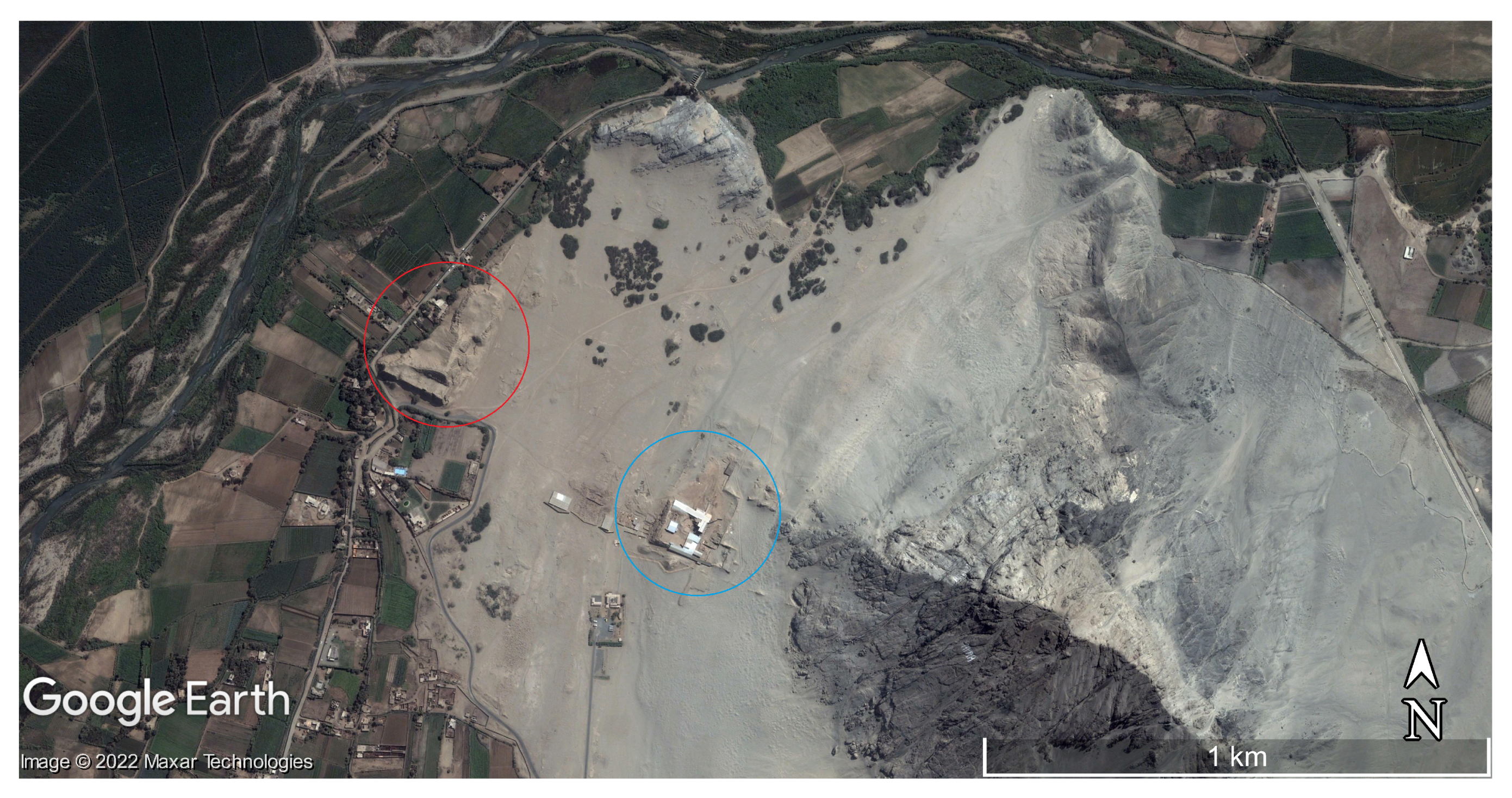
Figure 3.
Caballo Muerto Archaeological Complex; 2021 satellite image (803′59″–804′53″ S, 7855′19″–7853′44″ W). The alluvial fan on which lies the main settlement of the complex is marked by a red line. Its stratigraphy should contain a wealth of data regarding El Niño events (see text).
Figure 3.
Caballo Muerto Archaeological Complex; 2021 satellite image (803′59″–804′53″ S, 7855′19″–7853′44″ W). The alluvial fan on which lies the main settlement of the complex is marked by a red line. Its stratigraphy should contain a wealth of data regarding El Niño events (see text).

Figure 4.
Pachacamac archaeological site; 2016 satellite image (1215′08″–1216′02″ S, 7655′08″–7653′31″ W). Old Temple and Urpi Kocha Lagoon are marked by a red circle and a blue circle, respectively. Archaeological and geological inferences on El Niño events were argued for by the authors [23,90,134].

Figure 5.
Cahuachi ceremonial center; 2022 satellite image (1448′41″–1449′30″ S, 7507′45″–7506′11″ W). The monumental building area investigated by Grodzicki [20,21], Orefici [144], and Delle Rose et al. [26] is marked by a red line.

Figure 6.
Rio Muerto sub-basin; 2020 satellite image (1717′58″–1718′45″ S, 7059′11″–7057′34″ W). The sample point of the Miraflores Unit [51] is indicated by the red arrow (see text). Upstream, the cracked hill-slope area of regolith production may be observed.
Figure 6.
Rio Muerto sub-basin; 2020 satellite image (1717′58″–1718′45″ S, 7059′11″–7057′34″ W). The sample point of the Miraflores Unit [51] is indicated by the red arrow (see text). Upstream, the cracked hill-slope area of regolith production may be observed.

Table 1.
WoS/Scopus database search modes.
| Search Field | Search Phrase | Document Type | |
|---|---|---|---|
| WoS | TS = Topic (Title, Abstract, Author Keywords, and Keyword Plus) | (((TS = (“El Nino*” OR Nino* OR ENSO OR “El Nino Southern Oscillation”)) AND TS = (Peru OR Ecuador OR Chile)) AND TS = (landscape* OR settlement* OR site* OR archaeolog*)) | Articles, Review Articles, Proceedings Papers, Early Access, Book Chapters |
| Scopus | TITLE-ABS-KEY (Article Title, Abstract, and Keywords) | (TITLE-ABS-KEY (El Nino* OR Nino* OR ENSO OR El Nino Southern Oscillation) AND TITLE-ABS-KEY (Peru OR Ecuador OR Chile)) AND TITLE-ABS-KEY (landscape* OR settlement* OR site* OR archaeolog*)) | Article, Conference Paper, Conference Review, Review, Book Chapter |
Table 2.
Summary of identification, selection, and full-text examination stages.
| WoS | Scopus | ||
|---|---|---|---|
| Database mined documents | 383 | 306 | |
| After duplicate check | 383 | 305 | |
| Documents found in both databases | 230 | ||
| Identified documents | 458 | ||
| Excluded after abstract evaluation | 337 | 402 | 261 |
| Selected documents | 46 | 56 | 44 |
| From bibliography of selected works | 14 | ||
| Reviewed documents | 70 |
Table 3.
Summary of reviewed documents. BSD = Bibliography of selected documents.
| Author(s) and Year | Source | Sites/Study Areas |
|---|---|---|
| Nials et al., (1979 a, b) [14,15] | BSD | Huaca del Sol and 2 other sites (Moche Valley) |
| Samaniego et al. (1985) [78] | BSD | Cerro Sechin (Casma Valley) |
| Craig and Shimada (1986) [16] | Scopus | Batan Grande (La Leche Valley) |
| Sandweiss (1986) [79] | Scopus | Las Salinas (North coast of Santa mouth) |
| Rollins et al. (1986) [80] | Scopus | Las Salinas (North coast of Santa mouth) |
| DeVries (1987) [81] | BSD | Review article |
| Wells (1987) [82] | BSD | 7 sites (Casma Valley) |
| Wells (1990) [17] | BSD | 7 sites (Casma Valley) |
| Grodzicki (1992) [20] | BSD | Pampa de Nazca (Nazca Valley) |
| Moseley and Richardson (1992) [83] | BSD | Huaca del Sol (Moche Valley) |
| Moseley et al. (1992) [84] | BSD | Las Salinas (North coast of Santa mouth) |
| Ortlieb and Machare (1993) [85] | WoS, Scopus | Review article |
| Uceda and Canziani Amico (1993) [86] | BSD | Huaca de la Luna (Moche Valley) |
| Grodzicki (1994) [21] | BSD | Cahuachi and other 3 sites (Nazca Valley) |
| Keefer et al. (1998) [87] | BSD | Quebrada Tacahuay (Moquegua Valley) |
| Wells and Noller (1999) [88] | Scopus | Review article |
Table 4.
Summary of reviewed works. This table continues from Table 3.
Table 4.
Summary of reviewed works. This table continues from Table 3.
| Author(s) and Year | Source | Sites/Study Areas |
|---|---|---|
| Veit (2000) [89] | Scopus | Review article |
| Franco and Paredes (2000) [90] | BSD | Pachacamac (Lurin Valley) |
| Satterlee et al. (2000) [22] | BSD | Quebrada Miraflores (North coast of Moquegua mouth) |
| Magilligan and Goldstein (2001) [24] | WoS, Scopus | Rio Muerto (Moquegua Valley) |
| Sandweiss et al. (2001) [55] | WoS, Scopus | Review article |
| Van Buren (2001) [91] | WoS | Review article |
| Calderoni et al. (2002) [61] | Scopus | Mejia (Tambo Valley) |
| Huckleberry and Billman (2003) [92] | WoS, Scopus | Quebrada de los Chinos (Moche Valley) |
| Keefer et al. (2003) [93] | WoS, Scopus | Review article |
| Dillehay et al. (2004) [94] | WoS, Scopus | Los Mochicas del Norte Valleys |
| Federici and Rodolfi (2004) [95] | WoS, Scopus | Ensenada de Atacames, Ecuador |
| Keefer and Moseley (2004) [96] | WoS, Scopus | lower Moquegua Valley |
| Brooks et al. (2005) [97] | WoS, Scopus | Santa Rita (Chao Valley) |
| deFrance and Keefer (2005) [98] | WoS, Scopus | Quebrada Tacahuay (South coast of Moquegua mouth) |
| Eitel et al. (2005) [4] | WoS, Scopus | Quebrada Palpa (Grande Valley) |
| Zaro and Alvarez (2005) [99] | WoS, Scopus | Moquegua Valley and North coast of Moquegua mouth |
| Fabre et al. (2006) [100] | WoS, Scopus | Mollendo (North coast of Tambo mouth) |
| Machtle et al. (2006) [101] | WoS, Scopus | upper and middle Grande Valley |
| Manners et al. (2007) [50] | WoS | middle Moquegua Valley |
| Andrus et al. (2008) [102] | WoS, Scopus | Review article |
| Magilligan et al. (2008) [51] | WoS | 3 sites (Moquegua Valley) |
| Beresford-Jones et al. (2009a) [103] | WoS, Scopus | Samaca (Ica Valley) |
| Beresford-Jones et al. (2009b) [104] | Scopus | Samaca (Ica Valley) |
| deFrance et al. (2009) [105] | WoS | North and south coast of Moquegua mouth |
| Eitel and Machtle (2009) [106] | WoS | upper and middle Grande Valley |
| Mettier et al. (2009) [1] | WoS, Scopus | middle Piura Valley |
| Reindel and Wagner (2009) [107] | WoS | upper Grande Valley |
| Abbuhl et al. (2010) [108] | WoS, Scopus | middle Piura Valley |
| Beresford-Jones (2011) [109] | Scopus | Samaca (Ica Valley) |
| Bernal et al. (2011) [110] | WoS | Pastaza Valley, Ecuador-Peru area of Amazon Basin |
| Goldstein and Magilligan (2011) [111] | WoS, Scopus | upper and middle Moquegua Valley |
| Gayo et al. (2012) [112] | WoS, Scopus | Pampa del Tamarugal, Chile |
| Huckleberry et al. (2012) [113] | WoS, Scopus | middle La Leche Valley |
| Sandweiss and Kelley (2012) [114] | WoS, Scopus | Review article |
| Sandweiss and Quilter (2012) [115] | WoS | Review article |
| Winsborough et al. (2012) [23] | WoS, Scopus | Urpi Kocha Lagoon (Rio Lurin) |
| Etayo-Cadavid et al. (2013) [116] | WoS, Scopus | North and south coast of Moche mouth |
| Hanzalova and Pavelka (2013) [117] | Scopus | Ciudad Perdida de Huayuri (upper Grande Valley) |
| Macthle and Eitel (2013) [118] | WoS, Scopus | upper Grance Valley and middle Nazca Valley |
| Kalicki et al. (2014) [119] | Scopus | Lomas de Lachay (South of middle Huaura Valley) |
| Nesbitt (2016) [120] | WoS | Caballo Muerto Archaeological Complex (middle Moche Valley) |
| Caramanica and Koons (2016) [121] | WoS, Scopus | Pampa de Mocan (Chicama Valley) |
| Pavelka et al. (2016) [122] | WoS | Cantalloc (upper Nazca Valley) |
| Christol et al. (2017) [123] | WoS, Scopus | West coast of La Leche mouth |
| Wang et al. (2017) [124] | WoS | Salar Grande, Chile |
| Kalicki et al. (2018) [125] | WoS, Scopus | Lomas de Lachay (South of middle Huaura Valley) |
| Delle Rose et al. (2019) [26] | WoS, Scopus | Cahuachi (middle Nazca Valley) |
| Caramanica et al. (2020) [126] | WoS, Scopus | Pampa de Mocan (Chicama Valley) |
| Kalicki and Kalicki (2020) [127] | WoS | Lomas de Lachay (South of middle Huaura Valley) |
| Sandweiss et al. (2020) [13] | WoS, Scopus | Review article |
| Uceda et al. (2021) [128] | WoS, Scopus | Review article |
| Sandweiss and Maasch (2022) [129] | WoS, Scopus | Review article |
| Rubinatto Serrano et al. (2022) [130] | WoS, Scopus | Rio Muerto and 3 other sites (Moquegua Valley) |
Table 5.
Chronology of late pre-Hispanic El Niño events argued as possibly responsible for landscape modifications.
Table 5.
Chronology of late pre-Hispanic El Niño events argued as possibly responsible for landscape modifications.
| Date | Landscape Process | Basin or Site | Reference |
|---|---|---|---|
| ca. 1450 CE 1 | formation of alluvial terraces | Rio Casma | [17] |
| 1400–1450 CE 1 | mud deposition from runoff | Rio Moche | [133] |
| 1360–1350 CE 1 | debris flow activation, flood sedimentation | Q. Miraflores, Rio Moquegua, Rio Muerto | [22,24,51,84] |
| 1325 CE 1 | formation of alluvial terraces | Rio Casma | [17] |
| ca. 1100 CE 2 | flood sedimentation | Huacas de Moche | [14,15] |
| 1008–995 CE 1 | mud deposition from runoff | Pachacamac | [23] |
| 1000–650 CE 2 | flood sedimentation | Batan Grande | [16] |
| 730–690 CE 1 | debris flow activation, flood sedimentation | Rio Muerto, Rio Moquegua | [24,51] |
| 651–436 CE 1 | mud deposition from runoff | Urpi Kocka | [23] |
| ca. 600 CE 2 | mud deposition from runoff | Pachacamac | [18,90] |
| ca. 600 CE 2 | mud deposition from runoff | Huacas de Moche | [86] |
| 600–550 CE 2 | flood sedimentation | Samaca | [103,104,109] |
| ca. 0 CE 1 | formation of alluvial terraces | Rio Casma | [17] |
| 100 BCE 1 | debris flow activation | Rio Muerto | [51] |
| 900–1100 BCE 2 | mud deposition from runoff | Caballo Muerto | [120] |
| ca. 1200 BCE 1 | formation of alluvial terraces | Rio Casma | [17,82] |
| ca. 1450–1600 BCE 1 | mud deposition from runoff | Caballo Muerto | [120] |
1 calibrated 14C age; 2 date inferred from archaeological remains.
Publisher’s Note: MDPI stays neutral with regard to jurisdictional claims in published maps and institutional affiliations. |
© 2022 by the author. Licensee MDPI, Basel, Switzerland. This article is an open access article distributed under the terms and conditions of the Creative Commons Attribution (CC BY) license (https://creativecommons.org/licenses/by/4.0/).
Share and Cite
MDPI and ACS Style
Delle Rose, M. Landscape Modifications Ascribed to El Niño Events in Late Pre-Hispanic Coastal Peru. Land 2022, 11, 2207. https://doi.org/10.3390/land11122207
AMA Style
Delle Rose M. Landscape Modifications Ascribed to El Niño Events in Late Pre-Hispanic Coastal Peru. Land. 2022; 11(12):2207. https://doi.org/10.3390/land11122207
Chicago/Turabian StyleDelle Rose, Marco. 2022. "Landscape Modifications Ascribed to El Niño Events in Late Pre-Hispanic Coastal Peru" Land 11, no. 12: 2207. https://doi.org/10.3390/land11122207
Note that from the first issue of 2016, this journal uses article numbers instead of page numbers. See further details here.