1. Introduction
Rapid urbanization worldwide is changing land cover significantly [
1]. The world’s urban population accounted for about 33% in 1950 and increased to 54% in 2014 [
2]. At the global scale, the percentage of urban land to the total land increased from 0.23% in 1992 to 0.53% in 2013 [
1]. The implementation of China’s economic reform and open policy in 1978 stimulated dramatic urbanization and land expansion. In 1978, the urbanization rate of China was only 17.92%, exceeded 60% at the end of 2019, and is expected to increase to 70% by 2030 [
3]. From 1985 to 2018, the mean growth rate of built-up areas in China was 4663 km
2 per year, which was much faster than that in other countries. In 2015, China became the country with the most built-up areas in the world [
4]. This unprecedented urban growth in China has significant impacts on ecological security [
5], environmental quality [
6], and agricultural production [
7], all of which finally influence human health and well-being [
4].
To inform sustainable development and land use planning, a rich body of literature has already investigated the driving factors of urban land expansion in China. Scholars have found that urban land expansion has been driven by urbanization [
8], marketization [
9], industrialization [
10], and transport networks [
11]. Furthermore, political and institutional factors are also extensively mentioned in the literature, suggesting that urban expansion is not merely a result of market forces but also shaped by government behavior [
8]. Under the current land use system in China, local governments are the sole legitimate providers of newly increased urban construction land [
12]. Especially after the reform of tax-sharing and the land market in China, land conveyance fees have rapidly increased and become the most important resource for local revenue, which enable local governments to attract investments, develop infrastructures, and stimulate urban economic growth [
9,
13]. Thus, the ability and incentive of local government to expand urban land have inevitably triggered unprecedented land urbanization in China.
By emphasizing government behavior and the inflexible administrative system in China, recent studies have paid more attention to the triple spatial effects (i.e., heterogeneity, radiation, and segmentation) of the administrative hierarchy on urban land development, which can be attributed to the vertical and horizontal structure of the urban administrative system.
From the vertical perspective, the urban administrative units are structured into three primary levels of local government, namely the province level, the prefecture level, and the county level [
14]. In the transition process of decentralization, important administrative powers have devolved from the central state, level by level [
9]. Higher administrative levels correspond to stronger land administration power (e.g., the autonomy of land use planning) [
9,
15] and higher political capability to make locally privileged policies to attract the impetuses of urban growth (e.g., development zones and foreign investment) [
9]. Thus, urban land expansion tends to coincide with the administrative level, presenting heterogeneity across different administrative levels. For example, Liu et al. found that cities with higher administrative levels tended to expand at a higher speed [
3].
From the horizontal perspective, the urban administrative units at the same level engage in intense cooperation and competition, leading to radiation and segmentation effects on built-up areas [
16,
17]. On one side, to realize industrial upgrading and the scale economy, close cooperation has been formed among local governments [
18,
19]. Especially in the emergence process of urban agglomeration, communication enhancement and integration development have emerged through the high-dense connection between central and adjacent administrative units [
20]. In this case, the spatial spillover between central and adjacent administrative units is stronger than between two peripheral units. For example, Cen et al. stated that administrative central cities demonstrated a radiation effect on the surrounding cities in terms of urban land development [
17]. On the other side, local governments are controlled by the central government via gross domestic product (GDP) centric promotion competition [
21]. To gain an advantage in the competition, local government often establishes market barriers and administrative interventions to maximize local economics based on administrative division [
22]. As urban land is the most important resource for local government to acquire revenue and promote economics [
15], it also demonstrates the segmentation characteristics across an administrative boundary. For instance, Wang et al. revealed that provincial boundaries significantly restrict the spatial spillover effect between county-level units that are not located in the same province [
16].
To summarize, due to the vertically tiered structure and horizontal cooperation and competition, the administrative hierarchy has shown multiple spatial effects on urban land development, including heterogeneity, radiation, and segmentation. A rich body of literature has paid attention to these effects, but the existing research has mainly focused on a single effect. The parallel and distinct research have provided limited understanding and resulted in partial and potentially misleading conclusions about land urbanization in China. Thus, a more comprehensive theoretical and modeling framework is urgently needed to fully reveal the land urbanization mechanisms under the Chinese administrative hierarchy.
Drawing upon high-resolution land use data extracted from remote sensing images, this study aims to fill this research gap and contribute a comprehensive and integrated framework to investigate the link between Chinese administrative hierarchy and urban built-up areas, taking Fujian province as a study case. Based on descriptive statistics, this study will demonstrate that the administrative hierarchy has triple spatial effects on built-up areas (i.e., heterogeneity, radiation, and segmentation), stemming from the vertical and horizontal interaction among the administrative units. By applying a spatially explicit model named the spatial lag model with regimes, this study will further deal simultaneously with the triple effects of the administrative hierarchy in a single spatial econometric model, showing that the administrative hierarchy not only plays a proactive role in built-up area development but also has a profound impact on other driving forces of built-up area expansion.
3. An Analytical Framework
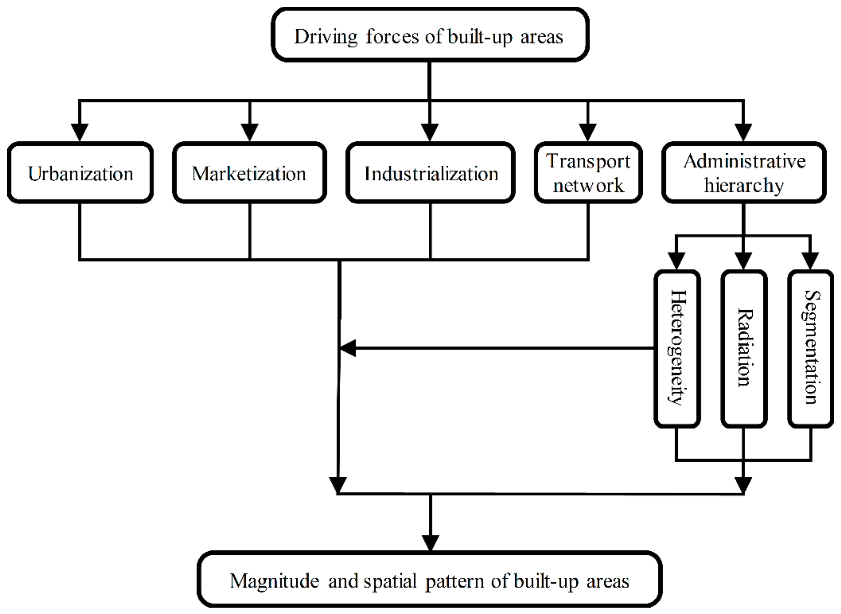
To comprehensively investigate the effects of the Chinese administrative hierarchy on built-up areas, we propose an analytical framework to better summarize the mechanism of built-up areas’ development (
Figure 1).
First, in the context of the Chinese socio-economic transition, urbanization, marketization, and industrialization are broadly recognized as the primary processes that affect urban land expansion [
8,
9,
10]. Specifically, factors considered as significant driving forces of urban land include demographic urbanization, GDP, and enterprise development [
8,
10]. Moreover, many studies have stated that the transportation network also plays a key role in urban land expansion [
11].
Second, the administrative hierarchy in China has triple spatial effects on built-up areas, including heterogeneity, radiation, and segmentation. From the vertical perspective, as the administrative powers and economic resources are distributed unevenly across different hierarchy levels, the magnitudes and driving forces of built-up areas tend to be sensitive to the tiered structure of the administrative hierarchy. From the horizontal perspective, local governments at the same administrative level engage in intensive cooperation and competition. The cooperation relationship leads to a spatial spillover effect between adjacent administrative units [
35], and the administrative central cities demonstrate a radiation effect on nearby administrative units. At the same time, the competitive relationship induces a spatial segmentation effect between adjacent administrative units, which can restrict the radiation effect of administrative central cities across the administrative boundary.
Third, under the Chinese administrative system, the administrative territory of prefecture-level cities is divided into two categories: municipal districts and county-level units, which are the most significant levels that local government rushed to take land from the farmers and expand urban land [
37,
38]. However, previous studies concerned with the effects of administrative hierarchy on urban land have mainly focused on cities at the prefectural level, and above, the effects at municipal districts and county-level units are still unexamined [
9,
10]. This study tries to fill this gap and investigate the triple spatial effects at relatively lower administrative levels, including the heterogeneity characteristics between municipal districts and county-level units, the radiation effects of municipal districts on nearby county-level units, and the segmentation effects of prefectural boundaries on the radiation effects of municipal districts.
To summarize, in this study, we hypothesize that the administrative hierarchy has tripe effects on built-up areas’ development, including heterogeneity, radiation, and segmentation. Furthermore, we also argue that the triple effects should be investigated as a whole to fully understand the development mechanism of built-up areas, especially at the prefectural level and below, which are neglected by most previous studies.
4. Data and Study Area
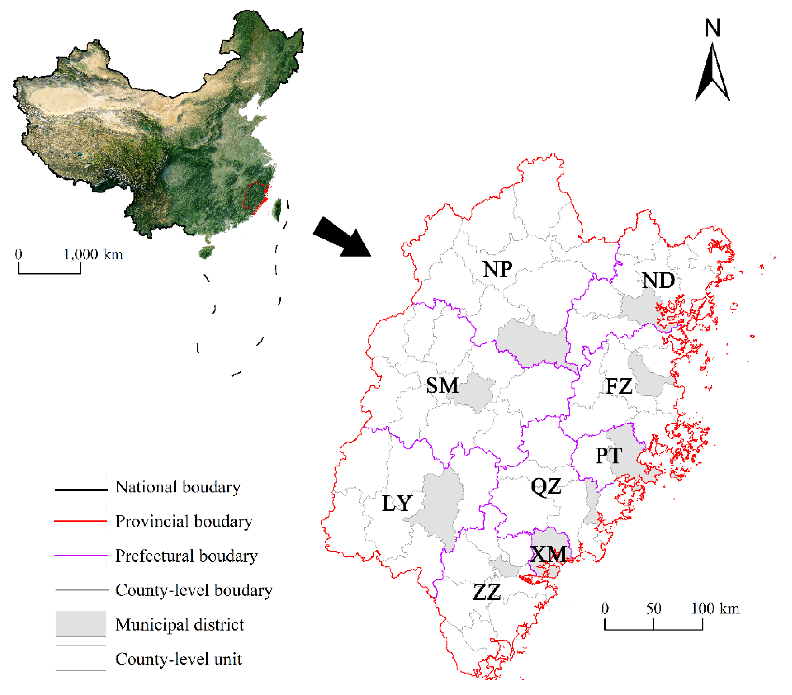
Fujian province is situated on the southeast coast of China. It is adjacent to Zhejiang province in the northeast, bordering Jiangxi province in the northwest, and neighboring Guangdong province in the southwest. As the connection channel of the two largest and most important urban agglomerations in China (i.e., the Yangtze River Delta and the Pearl River Delta), Fujian province is a vital part of China’s coastal economic belt and plays a prominent role in the national economic development layout.
Fujian province has a long history of city building. For example, Fuzhou, the capital of Fujian Province, is a famous historical and cultural city. However, until the reform and opening up, the cities in Fujian Province were relatively small. Specifically, the built-up areas of Fujian province were only 259 km
2 in 1990 and dramatically increased to 1335 km
2 in 2020 [
39], with an annual growth rate of 13.4%. In terms of the spatial distribution characteristics, the built-up areas present evident heterogeneity. First, the built-up areas are mainly concentrated in two central cities, Fuzhou and Xiamen, which are the provincial capital and economic center of Fujian province, respectively. For example, the two cities accounted for 52% of Fujian province in 2015 regarding the built-up areas in municipal districts [
39]. Second, the built-up areas in the west are much lower than that in the east of Fujian province, where the economy is more prosperous. For example, in terms of the built-up areas in municipal districts in 2015, the mean built-up area of three prefectural cities in the west is 45.3 km
2, while that of six prefectural cities in the east is 162.8 km
2 [
39]. The significant uneven distribution indicates that administrative hierarchy and economic development profoundly affect the built-up areas.
The territory of Fujian province mainly consists of mountains and hills, accounting for more than 80% of the total area. Thus, the scarcity of available land resources has gradually limited urban expansion. Governing built-up areas’ development to align economic demands with limited land resources is a challenging task for the local government. Consequently, holistically and comprehensively understanding the development mechanism of built-up areas to support sustainable land use in Fujian province is urgently needed.
In terms of administrative hierarchy, Fujian province has jurisdiction over nine prefecture-level cities. The administrative territory of prefecture-level cities is divided into two categories: municipal districts and county-level units. The municipal districts are under the direct control of prefectural governments, and county-level units include counties and county-level cities. By the end of 2015, Fujian province had a total of 44 counties and 13 county-level cities. Most of the prefectural cities have at least five county-level units, but Putian only has one county. In addition, since Tong’an county was upgraded to a municipal district in 1997, Xiamen has no county-level units. It should be pointed out that Yongding county and Jianyang city were upgraded to municipal districts in 2014 and 2015, respectively. Considering this happened at the end of the study period (i.e., 2005–2015), these two units are regarded as county-level units in this study. Finally, as Jinmen county only consists of some small islands and no evident urban built-up areas can be found there, it was removed from the study area (
Figure 2).
Data used include the land use dataset with a resolution of 30 m, obtained from the Data Center of Resources and Environmental Sciences, the Chinese Academy of Sciences (
http://www.resdc.cn/, accessed on 14 December 2018). This dataset is considered one of the most accurate Chinese land use datasets (e.g., the accuracy of urban land is higher than 93%) and is widely used in the empirical research of urban land in China [
40]. From this dataset, we extracted the urban built-up areas of Fujian province in 2005 and 2015. The statistical data for regression analysis (e.g., population and GDP) were collected from the Fujian Statistical Yearbook (2006 and 2016).
5. Method
5.1. Descriptive Statistics
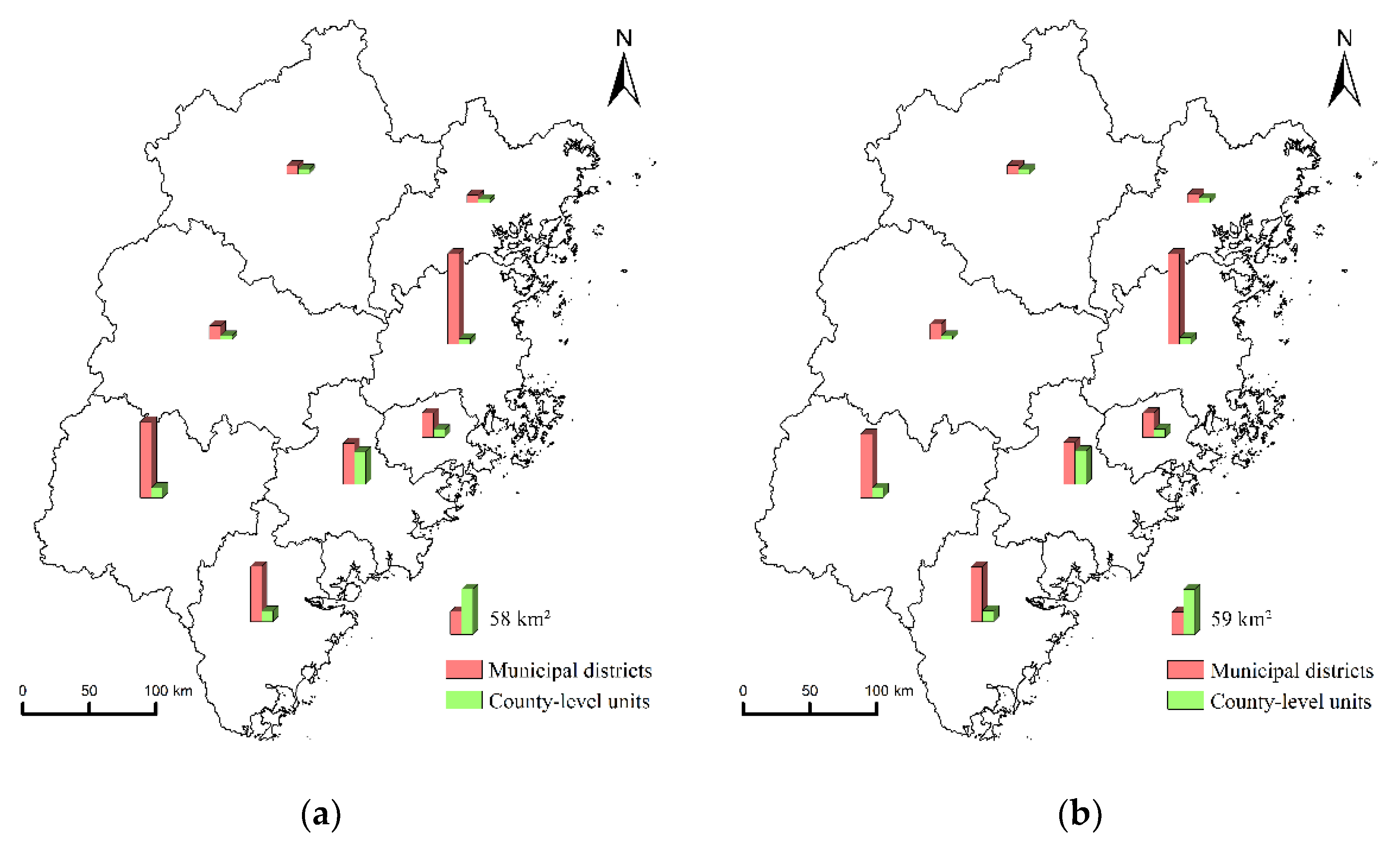
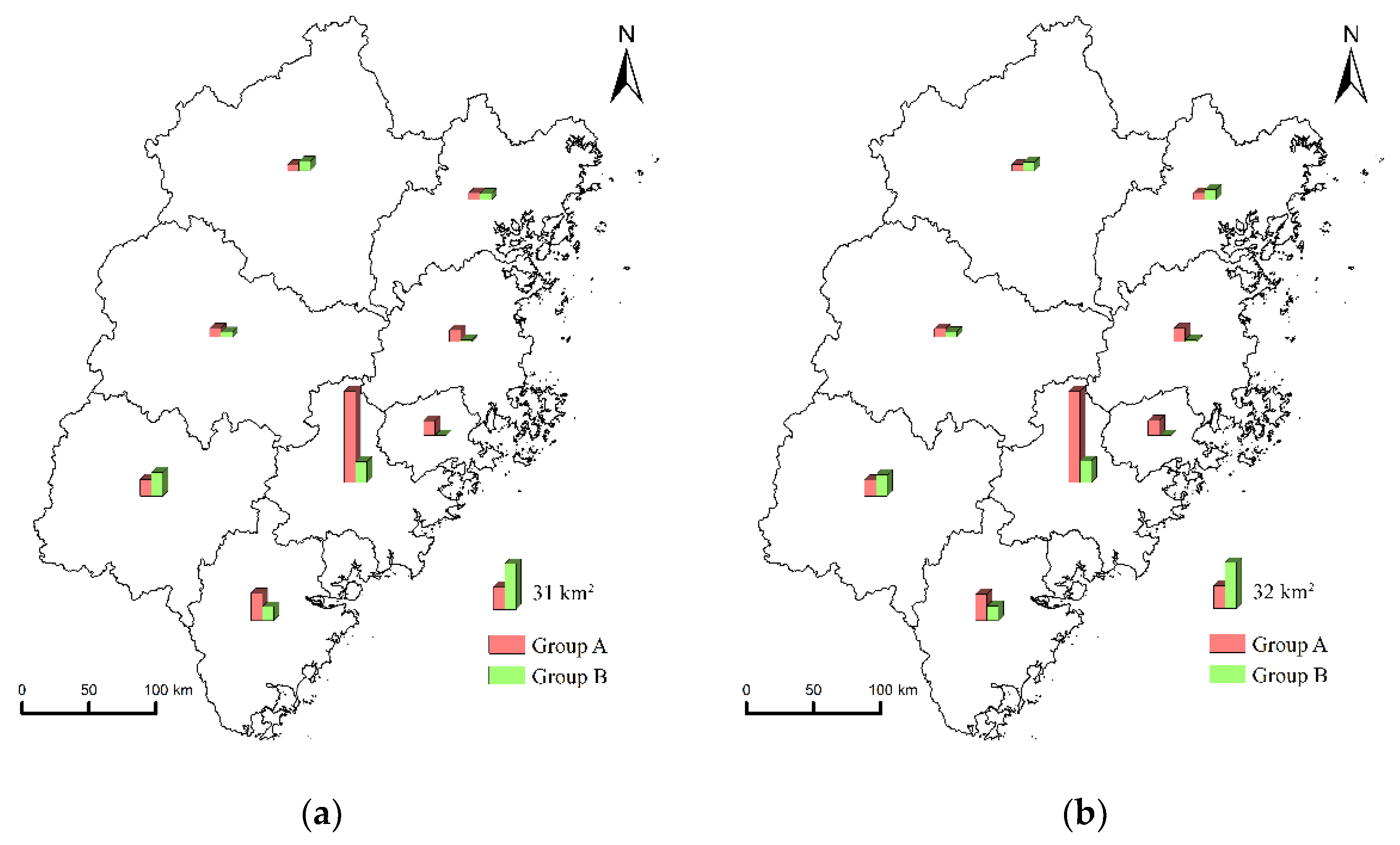
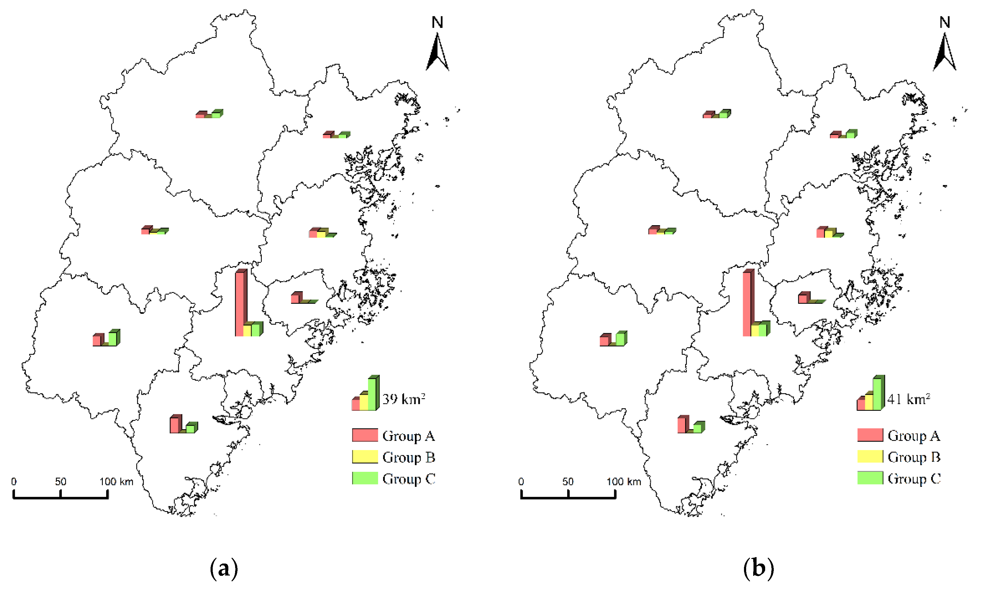
Several descriptive statistics (i.e., minimum, median, mean, and maximum) were applied to reveal the triple spatial effects of the administrative hierarchy on built-up areas, including heterogeneity, radiation, and segmentation effects. First, the magnitudes of built-up areas of municipal districts and county-level units were compared. If the former was higher than the latter, this revealed the heterogeneity characteristics of the built-up areas, and the built-up areas coincided with the administrative hierarchy. Second, 58 county-level units of Fujian province were divided into two groups. The first group was the neighbors of municipal districts, while the second group was not. If the former was higher than the latter, this indicated the radiation effects of municipal districts on nearby county-level units. Third, 58 county-level units of Fujian province were further divided into three groups. The first group was the neighbors of municipal districts, and these county-level units and their adjacent municipal districts were in the same prefectural city. The second group was also the neighbors of municipal districts, but these county-level units and their adjacent municipal districts were in different prefectural cities. The third group was the county-level units not adjacent to municipal districts. If the built-up areas in the second group were smaller than the first group, or even comparable to the third group, this indicated that the radiation effects of municipal districts were restricted by prefectural boundaries, representing the spatial segmentation effect of administrative hierarchy.
5.2. Spatial Econometric Model
Some scholars have posited that built-up areas are driven by urbanization, marketization, industrialization, and transport network [
8,
9,
10,
11]. Considering the evident impacts of the administrative hierarchy on built-up areas, two approaches were proposed to add the administrative hierarchy into the regression model to adapt to the unique institutional background of China.
In the first approach, Wei et al. examined the heterogeneity characteristics of urban land development mechanisms using the spatial regime model:
where the subscripts 1 and 2 indicate different regimes (i.e., different administrative levels);
y1 and
y2 are vectors of observations on the dependent variable (urban land) for spatial regimes 1 and 2, respectively;
X1 and
X2 are matrices of observations on the explanatory variables;
and
are vectors of the regression coefficients in each regime; and
and
are vectors of error terms.
The spatial regime regression can produce two sets of comparable coefficients dedicated to each administrative level, revealing the different mechanisms of urban land expansion across cities at different administrative levels.
In the second approach, some scholars have investigated the spatial spillover and segmentation effects of the administrative hierarchy on urban land development by embedding the administrative status into the spatial weight matrix of the spatial econometric model [
16,
34,
41].
To integrate the triple effects of the administrative hierarchy into one regression model, we combined the two approaches by employing the spatial econometric model with regimes. The spatial econometric model has two forms: the spatial lag model and the spatial error model.
In terms of the spatial lag model, spatial regime regression is extended with a spatially lagged dependent variable:
the spatially lagged dependent variable is constructed with the spatial weight matrix
W and spatial autoregressive coefficient
ρ. The independent variables in each regime (i.e.,
y1 and
y2) are the built-up areas extracted from the land use map. Other parameters in Equation (2) are the same as in Equation (1).
In terms of the spatial error model, spatial regime regression (Equation (1)) is extended with a spatial autoregressive process in the error terms:
where
W is the spatial weight matrix,
λ is the spatial autoregressive parameter,
u1 and
u2 are the idiosyncratic error vectors belonging to each regime, and
and
are the same as Equation (1).
Using the spatial econometric model with regimes, spatial heterogeneity and spillover effects can be dealt with simultaneously. Specifically, regression coefficients specific to municipal districts and county-level units can be derived from the model, representing the heterogeneity effects of the administrative hierarchy. Moreover, the impact of the administrative hierarchy on the spillover effects between administrative units (including radiation and segmentation effects) can also be examined by embedding the administrative structure into a spatial weight matrix, which is explained in
Section 5.3. The regression analysis of this study uses the python software package spreg(1.2.4), the spatial econometrics module of PySAL library [
42].
Moreover, several statistics were employed for regression diagnosis: (1) The Lagrange multiplier test statistics were applied as the detector for spatial dependence and the criterion to use either the spatial lag model or spatial error model. In this study, the Lagrange multiplier tests suggested that the hypothesis of no spatial spillover effects should be rejected and the spatial lag model should be adopted rather than the spatial error model. (2) Two versions (i.e., global and individual) of Chow tests were employed to see whether there was a significant difference between the coefficients across different levels of the administrative hierarchy. (3) The Anselin–Kelejian test was used to assess whether the residuals of the spatial econometric model with regimes exhibited a spatial pattern.
5.3. Spatial Weight Matrix Construction
As mentioned in
Section 5.2, the spatial econometric model with regimes can be applied to explore the heterogeneity characteristics of built-up development mechanisms between municipal and county-level units. The model can further reveal the impacts of administrative hierarchy on the spillover effects of built-up areas (including radiation and segmentation effects) by embedding the administrative structure into a spatial weight matrix.
Initially, the built-up areas in one administrative unit are assumed to be affected by the adjacent units, and this effect has a close connection with the administrative status. Then, based on the spatial adjacent relations across the administrative hierarchy, 3 scenarios were devised, and these spatial adjacent relations were embedded into the spatial weight matrices in spatial econometric models. Finally, the results of the spatial econometric models were used to verify this spatial effect of the administrative hierarchy on built-up areas.
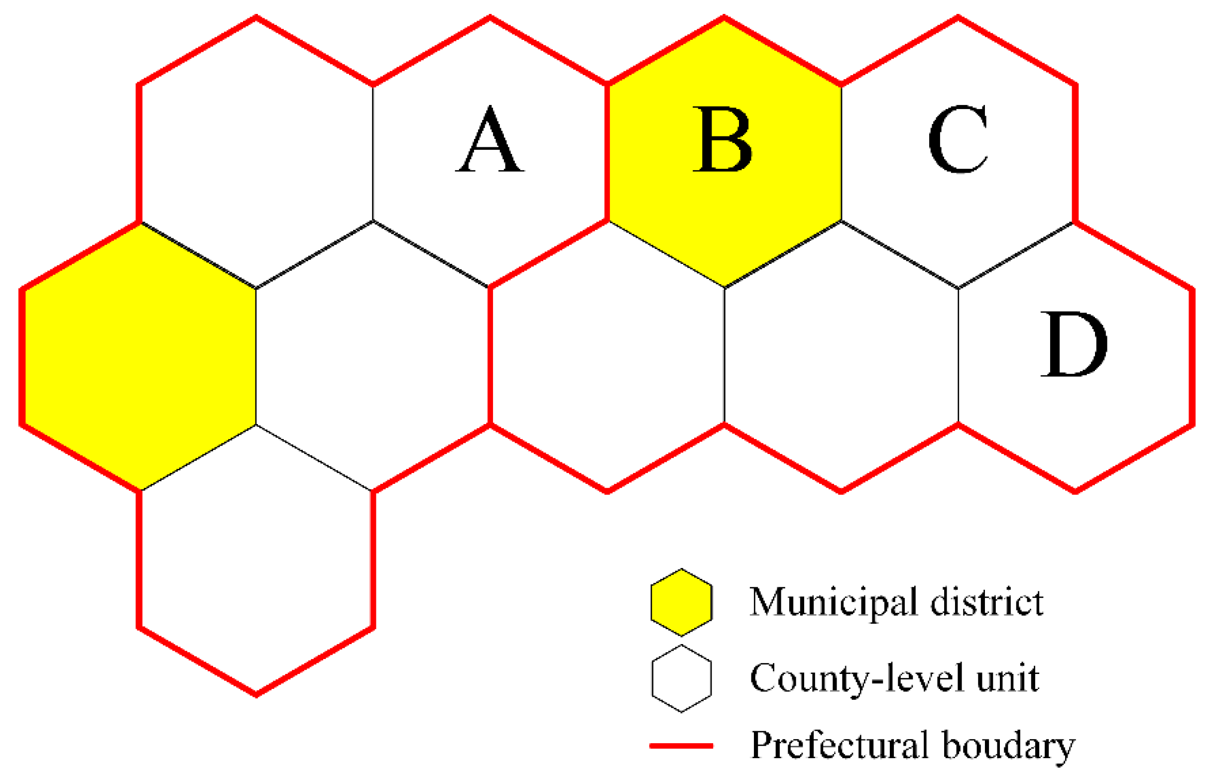
As shown in the schematic diagram of administrative hierarchy (
Figure 3), the administrative territory of prefecture-level cities consists of municipal districts and county-level units, and there are three types of spatial adjacent relations between municipal districts and county-level units. Adjacent type I is two county-level units that are adjacent to each other (e.g., C and D). Adjacent type II is a county-level unit adjacent to a municipal district, and they are located in the same prefectural city (e.g., C and B), indicating the interaction between different administrative levels. Adjacent type III is also a county-level unit adjacent to a municipal district, but they are located in different prefectural cities (e.g., A and B), implying the composition effect of the interaction between different administrative levels and the potential segmentation caused by prefectural boundaries.
As shown in Equation (4), these spatial adjacent types are embedded into the spatial weight matrices through parameters
α and
β: (1) The spatial weight is 0, if the administrative units i and j are not adjacent. (2) The spatial weight is 1, if the adjacent relationship of i and j is type I. (3) The spatial weight is 1 +
α, if the adjacent relationship of
i and
j is type II, where
α is the indicator reflecting the radiation effect of a higher administrative level. (4) The spatial weight is 1 +
α ×
β, if the adjacent relationship of
i and
j is type III, where
β is the indicator representing the segmentation effect of the prefectural boundary.
As a simplified example, the spatial weight matrix of
A,
B,
C, and
D can be expressed as:
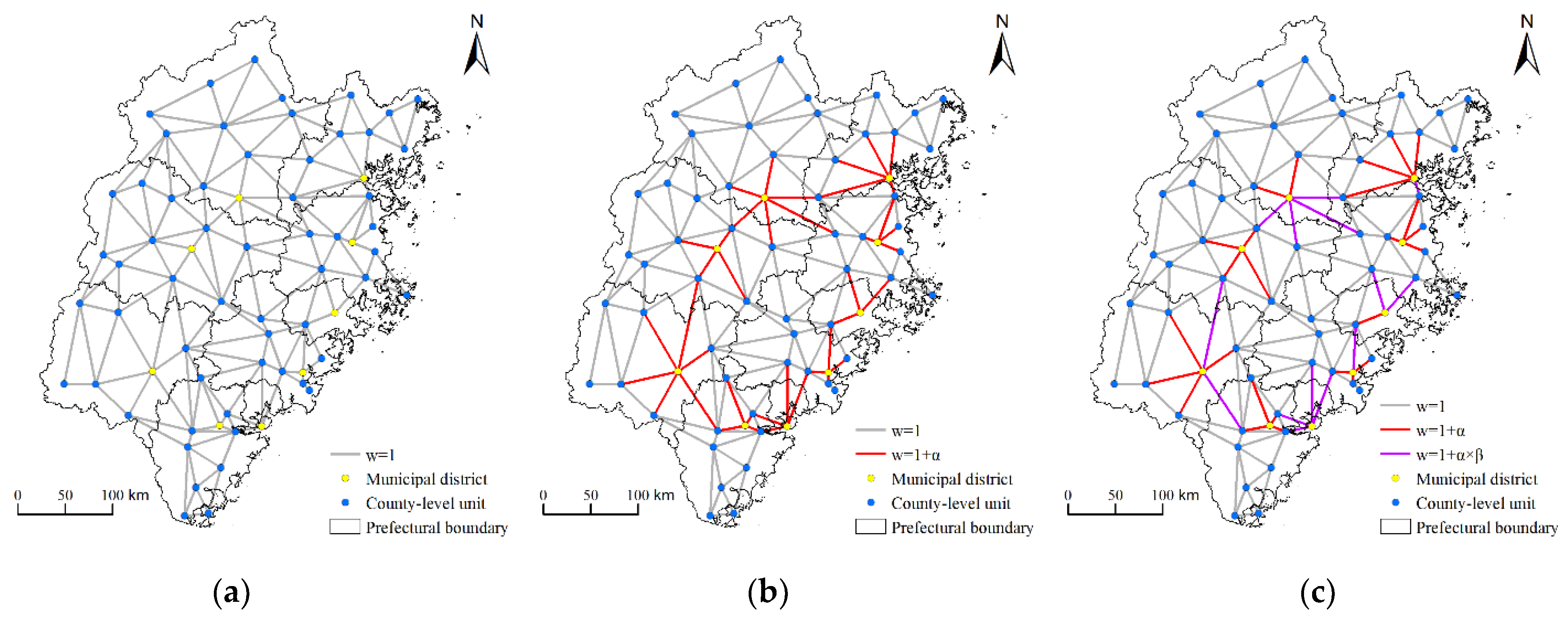
By controlling the values of
α and
β, three scenarios with different spatial weight matrices were constructed for further spatial econometric modeling (
Figure 4). In scenario 1, both
α and
β were set to 0. This means that the spatial weight matrix is constructed with general queen contiguity regardless of administrative status/level. In scenario 2,
α was set to be larger than 0, while
β was set to 0, indicating that we only consider the radiation effect of municipal districts. In scenario 3, both α and β were set to be larger than 0, and
β was further restricted to a value smaller than 1. Compared with scenario 2, scenario 3 further considered the reduction in the radiation effect, which was caused by the segmentation effect of the prefectural boundary. We evaluated multiple combinations of the candidate values of
α and
β, looking for regression models that best explain the dependent variable within the context of regression diagnosis criteria, such as the Anselin–Kelejian test and the spatial pseudo R-squared. In this study,
α was assigned a value of 1.5 and 1 in 2005 and 2015, respectively;
β was assigned a value of 0.1 and 0.8 in 2005 and 2015, respectively.
To summarize, under these scenarios, the radiation and segmentation effects of the administrative hierarchy are integrated into the spatial weight matrix by controlling parameters α and β. By analyzing the spatial econometric modeling under these scenarios, we can investigate the radiation effect of municipal districts and the segmentation effect of prefectural boundaries.
5.4. Control Variables of Regression
In
Section 5.2 and
Section 5.3, the dependent variable (i.e., built-up areas) and how the administrative hierarchy is embedded in the regression model are described and explained. According to our analytical framework (
Figure 1), the variables that represent urbanization, marketization, industrialization, and the transport network are also included in the regression as control variables:
Urbanization: as China has undergone urbanization, millions of rural migrants have flooded into cities, which is a prominent driving force of urban expansion [
8]. We selected the urbanization rate, urban population, and rural population to represent the demographic urbanization process. In addition, the literature mentioned that, along with the rural population transitioning to urban citizens, the rise in their income and consumption was found to increase land used to meet the rising demand for housing, production, and leisure spaces [
8,
10]. Thus, wages and social consumption were incorporated to reflect the socioeconomic aspects of urbanization.
Marketization: in the context of the marketization transition, labor and production factors have been allowed to flow freely and concentrate in cities, which has greatly promoted the urban economy. The expansion of the urban economy logically will have an impact on the growth of the urban areas [
8]. We used the GDP of the secondary industry and the GDP of the tertiary industry to represent the development status of the urban economy.
Industrialization: industrialization is the main process used to boost the local economy. Local governments generally invest heavily in the industrial sector to raise GDP, leading to the expansion of industrial land. The literature contended that industrial enterprise development was closely connected with urban expansion [
10]. We used the number of employees and enterprises’ profits and taxes to measure the development of industrial enterprises.
Transport network: transportation land is inherently an important type of built-up land use, and transportation construction requires land. Thus, transportation development is a crucial factor in promoting urban expansion. On the other hand, the development of transport networks facilitates inter-city and intra-city interaction, which can further affect urban growth [
11]. We used highway mileage to represent the development status of transport networks.
8. Conclusions
Due to rapid urbanization in the last four decades, Chinese cities have experienced dramatic land expansion. Under the land use system in China, local governments are the sole legitimate providers of newly increased urban land [
12]. More importantly, in the process of tax-sharing reform and marketization transition, urban land has been regarded as a unique and very significant resource for local revenue, and it has become the most important instrument of local government to promote economic growth and urban construction [
9]. Thus, urban land development has not been purely driven by market forces, and local governments have been playing a proactive role in this process. Since the organization of local governments is characterized by tiered political and economic power structures in a national hierarchy system, many studies have investigated the effects of administrative hierarchy on urban land expansion, such as heterogeneity, radiation, and segmentation. However, these studies mainly have focused on only one of these effects. As a result, these parallel and distinct studies have created a limited understanding that can result in partial and potentially misleading conclusions about urban land expansion in China. Contrary to previous literature, this study proposes a comprehensive theoretic and modeling framework to investigate the triple spatial effects of the administrative hierarchy as a whole. Furthermore, we focus on the relatively low levels of the administrative hierarchy (i.e., the prefectural level and below). These are the levels that have experienced much more intense land development [
37,
38] but have not received enough attention from previous studies.
This study advances the understanding of the triple spatial effects of administrative hierarchy (i.e., heterogeneity, radiation, and segmentation) on built-up areas by using a new comprehensive modeling approach to integrate the triple spatial effects as a whole.
From a theoretical perspective, we advance the understanding of the tripe effects of administrative hierarchy at the prefectural level and below. First, we revealed the heterogeneity characteristics of built-up areas by comparing municipal districts and county-level units, not only in terms of the magnitude but also in terms of the strengths of the driving forces. Moreover, we also discerned the radiation effect of municipal districts: a county-level unit would have more built-up areas if it is adjacent to a municipal district. Therefore, we further the understanding of the heterogeneity and radiation effect of the administrative hierarchy at the levels below prefectural cities, while previous studies have only focused on the prefectural level and above. Finally, we identified the segmentation effect of the prefectural boundary: the radiation effects of municipal districts on nearby county-level units are reduced if the county-level units are located in another prefectural city. Thus, we advance the understanding of the segmentation of administrative hierarchy at the prefectural level, while previous studies have only shown the administrative barriers to the spatial spillover of built-up areas at the provincial level. To summarize, compared with previous studies, we further verify that the triple effects of the administrative hierarchy are evident at the prefectural level and below, which have experienced more intensive land urbanization [
37,
38] but have not received enough attention from previous researchers.
From a modeling perspective, we propose a new approach to integrating the triple effects of administrative hierarchy on built-up areas into a single spatial lag model with regimes. Specifically, we handle the heterogeneity effect using spatial regimes and embed the radiation and segmentation effects into the spatial weight matrix through two parameters, α and β. Therefore, we improve the modeling method and can investigate the triple effects of administrative hierarchy simultaneously, while previous studies have merely focused on a single effect. As shown in
Section 6.2, if one or more effects are neglected, biased or even misleading regression results would be obtained. Thus, leveraging the new transferable modeling approach proposed in this study, the multiple facets of the administrative hierarchy effects can be handled as a whole and deserve more attention from those who care about the urbanization process in China. Such attention will lead to a thorough understanding of the mechanism of urban land expansion and enlighten the policy debates on better land use under China’s unique institutional environment.
From the perspective of international comparison regarding the connection between administrative hierarchy and urban development, Chinese and foreign scholars focused on different urban elements. Chinese scholars were mainly concerned with the built-up areas, while foreign scholars paid more attention to the population. For example, Heider et al. stated that administrative status significantly impacts urban growth [
23]. Unlike many Chinese case studies, they chose population as the indicator of urban growth. Furthermore, some scholars from the USA and the Netherlands investigated the differences in the migration patterns of different ages across different levels of administrative hierarchy [
24,
25]. In the case study of the Netherlands, de Jong et al. found that the “75 and older” age cohort is oriented towards smaller towns and rural areas, while the “65–74” age cohort is increasingly oriented toward urban areas [
25]. Considering the potential heterogeneity characteristics of built-up areas across the different levels of urban hierarchy, we argue that the effects of administrative hierarchy on urban land can be a new subject for foreign scholars.
The results of this study indicate that the effects of the administrative hierarchy result in divergence between different administrative levels and segregation across administrative boundaries. From the policy point of view, we argue for a reform and better design of the administrative arrangement to achieve balanced and integrated urban land development. Vertically speaking, the magnitudes and strengths of driving forces of built-up areas coincide with the administrative levels. The heterogeneity effect tends to reinforce the imbalances in land development and cause greater tensions between different levels of cities. We suggest reforming local land administrative rights and changing the constraint structures of local governments in the hierarchical system. Horizontally speaking, the radiation effect of municipal districts can promote the urban land expansion of nearby county-level units and helps alleviate the divergence of built-up areas between them. However, the segmentation effect of prefectural boundaries restricts the radiation effect and is a barrier to integrated urban land development. Therefore, breaking through the administrative barriers should be the next focus to optimize the structure of land use and improve the synergy of land development.
Foreign scholars also reported similar problems that stemmed from the inappropriate power arrangement of administrative hierarchy. For example, in a case study of Uyo (a midsized city in Nigeria), Etido found a lack of continuity in commitment to urban infrastructural development projects, which will hamper sustainable urbanization [
44]. He attributed the problem to fiscal management across the administrative hierarchy. Specifically, Uyo follows a system of disbursing funds from the state to the local governments, which limits local governments’ financial independence. Thus, regardless of Chinese and foreign countries, better design of the administrative arrangement is crucially important to achieve balanced and sustainable urban development.
China can learn from Germany and Japan, where a multi-tier government system has been widely used. In these countries, broader functions such as environmental protection and education can be managed by a higher level government, while decisions for the economy and people’s livelihood can be made by local governments. As Gu et al. stated, this design can enhance the cooperation between governmental power and city management [
45].
Finally, this study can be improved by considering more inter-city relationships that can affect urban land development. For instance, Zeng et al. argued that, besides the administrative hierarchy, spatial accessibility and social network should be integrated to provide a reference for urban policymakers [
41]. Integrating more inter-city relationships into our proposed approach may have the potential to further improve our understanding. Furthermore, we have only focused on the prefecture and county levels because our study area is only one province. Considering the province is another primary administrative level in China, we will explore the differences and interactions between these levels and the provincial level in our future research.


 ,
, 


