
Knowledge Map of Spatial Planning and Sustainable Development: A Visual Analysis Using CiteSpace


Abstract
:1. Introduction
1.1. Sustainable Development
1.2. Spatial Planning
1.3. Knowledge Map
1.4. CiteSpace
2. Research Methods
2.1. Data Sources
2.2. Analysis Methods
- CiteSpace needs to configure the Java environment, so the first step is to download and install the latest JRE.
- Interpretation (Figure 2b): Each circular node in the knowledge map represents a keyword. The lines between nodes represent the co-occurrence times of keywords; the more lines represent the closer connection between keywords, and the thicker lines represent the greater association strength. Node size indicates the frequency of occurrence of the keyword, and those in the same period are often expressed in the same color [18].
3. Results
3.1. Number of Published Papers on Spatial Planning (2006–2021)
- The 2006–2009 period was a stage of slow development, and there was little research on spatial planning, and it was mainly in the United Kingdom, Europe, and the United States, which was mainly about existing spatial planning theories and exploring new models.
- The 2010–2015 period was a period of accelerated development, and the number of studies gradually increased.
- The 2016–2020 period was a more rapid development period, during which spatial planning extended to more disciplines, and the discussions between disciplines were more abundant. The data were collected in October 2021, and so the data for 2021 is incomplete, but even so, the number for 2021 was at least higher than 220.
3.2. WOSCC
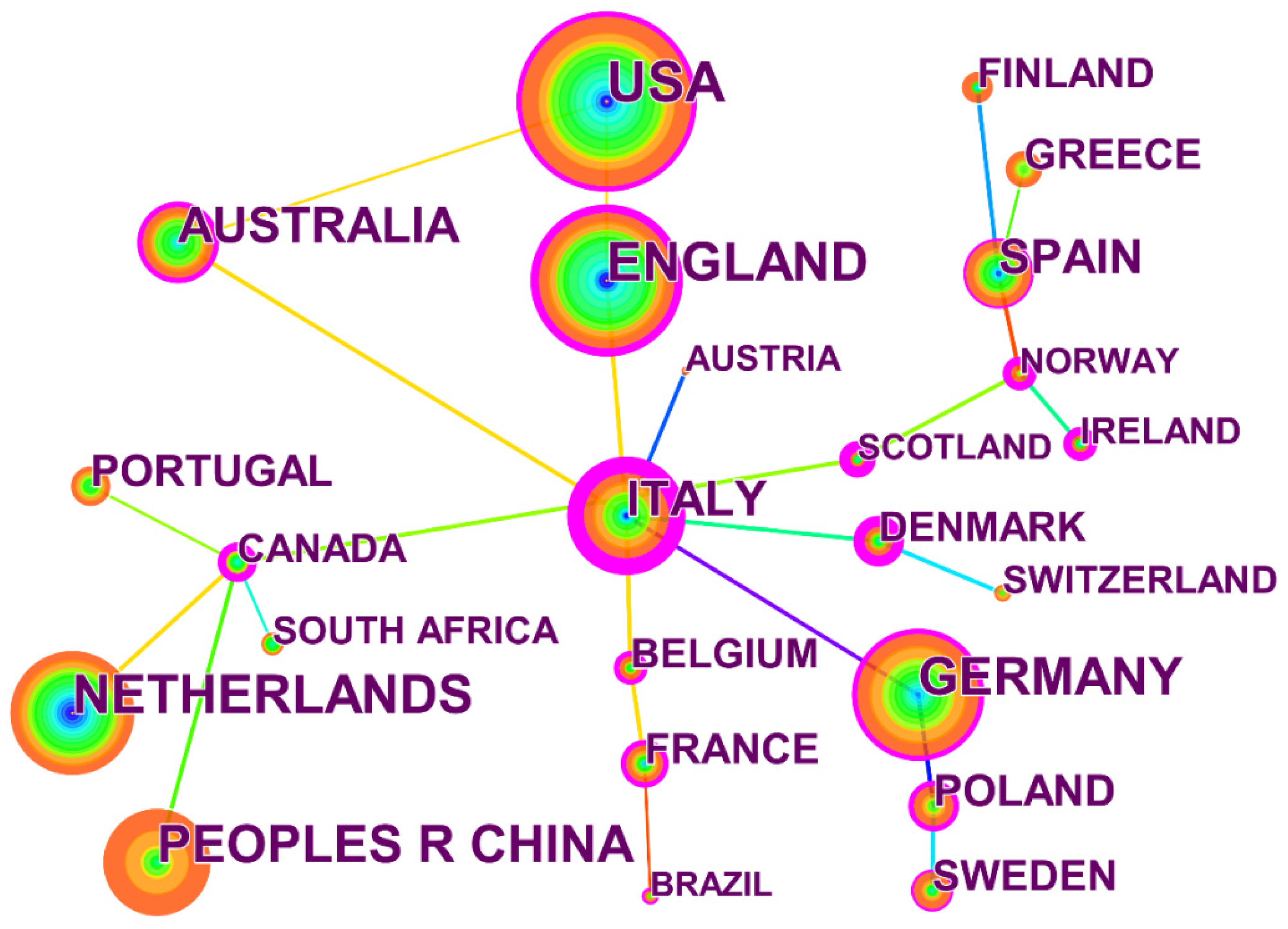
3.2.1. Country Collaboration Network
3.2.2. Discipline Categories Network
3.2.3. Author Analysis (WOSCC)
3.2.4. Time Zone Visualization
3.2.5. Co-Citation Analysis (WOSCC)
3.2.6. Timeline Visualization (WOSCC)
3.3. CNKI Database
3.3.1. Co-Citation Analysis (CNKI Database)
3.3.2. Author Analysis (CNKI Database)
3.3.3. Timeline Visualization (CNKI Database)
3.4. Comparison of Burst Keywords
4. Discussion
5. Conclusions and Prospects
- The number of papers published in global spatial planning research shows an increasing trend, while China starts many years later but develops rapidly, and its international influence increases rapidly. Especially after 2018, the number of papers shows an obvious increasing trend, which is coincident with the implementation of national policies.
- Globally, the United States has the largest number of relevant research results; the United Kingdom, Germany, New Zealand, and other countries have also published many studies, and Italy has the most cooperation with other countries. Different countries have different emphases on spatial planning research due to different national conditions and development stages. Developed countries have higher research levels and closer cooperation while developing countries are relatively weak and vulnerable to natural disasters and climate. However, China has developed rapidly in recent years and has gradually increased its influence.
- Disciplines such as environmental science and ecology, public administration, and regional and urban planning pay more attention to spatial planning. There is some cooperation between disciplines, but it is not very close.
- Globally, Stead D, Calado H, Gee K, and Jay S were key contributors. China has formed a research team with Jian Lin and Min Zhao as the core, which currently focuses on the discussion of territorial space planning and the idea of coordinated development of land and sea. Yumei Cai and others reviewed the spatial planning policies and experiences of developed countries and regions. However, the collaboration among authors is not strong enough, either internationally or in China.
- Through keyword cluster, timeline, and time zone analysis, global development can be roughly divided into three stages: The first stage is characterized by the study of spatial planning system theory, the second stage is characterized by building green infrastructure and providing ecological services, and the third stage is characterized by an emphasis on public participation and the establishment of equitable mechanisms. China’s development corresponds to three stages: the first stage is the theory and experience learning stage of developed countries, the second stage is the function establishment stage of the spatial planning system focusing on economic development, and the third stage is the integration of multiple plans and a sustainable development exploration stage.
- There are differences in burst words between the world and China, indicating that there are great differences in research hotspots in different countries’ periods and conditions.
Author Contributions
Funding
Institutional Review Board Statement
Informed Consent Statement
Data Availability Statement
Acknowledgments
Conflicts of Interest
References
- Patrizzi, N.S.; Dobrovolski, R. Integrating climate change and human impacts into marine spatial planning: A case study of threatened starfish species in Brazil. Ocean. Coast. Manag. 2018, 161, 177–188. [Google Scholar] [CrossRef] [Green Version]
- Shekhar, H.; Schmidt, A.J.; Wehling, H.-W. Exploring wellbeing in human settlements—A spatial planning perspective. Habitat Int. 2019, 87, 66–74. [Google Scholar] [CrossRef]
- Zhang, X.; Zhao, Y.; Jin, F.; Sun, W. Tracking hot spots of sustainable development research in domestic and foreign literature in the past twenty-five years: Bibliometric analysis based on CiteSpace. J. Univ. Chin. Acad. Sci. 2022, 39, 8. [Google Scholar]
- Fischer, T.B.; Muthoora, T.; Chang, M.; Sharpe, C. Health impact assessment in spatial planning in Englan—Types of application and quality of documentation. Environ. Impact Assess. Rev. 2021, 90, 106631. [Google Scholar] [CrossRef]
- Wiehe, J.; von Haaren, C.; Walter, A. How to achieve the climate targets? Spatial planning in the context of the German energy transition. Energy Sustain. Soc. 2020, 10, 10. [Google Scholar] [CrossRef]
- Zhang, Y.; Zhang, X.; Hu, Y. A review of spatial planning theory and practice at home and abroad. J. Anhui Jianzhu Univ. 2019, 27, 29–35. [Google Scholar]
- Luo, C.; Wang, G.; Sun, L. Research Review of Spatial Planning Development and Reform in China and Abroad. Urban Plan. Int. 2018, 33, 117. [Google Scholar]
- Högström, J.; Brokking, P.; Balfors, B.; Hammer, M. Approaching Sustainability in Local Spatial Planning Processes: A Case Study in the Stockholm Region, Sweden. Sustainability 2021, 13, 2601. [Google Scholar] [CrossRef]
- Nogués, S.; González-González, E.; Cordera, R. Planning regional sustainability: An index-based framework to assess spatial plans. Application to the region of Cantabria (Spain). J. Clean. Prod. 2019, 225, 510–523. [Google Scholar] [CrossRef]
- Gao, Z.; Tan, N.; Geddes, R.R.; Ma, T. Population Distribution Characteristics and Spatial Planning Response Analysis in Metropolises: A Case Study of Beijing. Int. Rev. Spat. Plan. Sustain. Dev. 2018, 7, 134–154. [Google Scholar] [CrossRef]
- Ran, J.; Nedovic-Budic, Z. Designing an Information Infrastructure for Policy Integration of Spatial Planning and Flood Risk Management. Int. J. E-Plan. Res. 2018, 7, 53–85. [Google Scholar] [CrossRef] [Green Version]
- Mustafa, A.; Bruwier, M.; Archambeau, P.; Erpicum, S.; Pirotton, M.; Dewals, B.; Teller, J. Effects of spatial planning on future flood risks in urban environments. J. Environ. Manag. 2018, 225, 193–204. [Google Scholar] [CrossRef]
- Sagala, S.A.H.; Suroso, D.S.A.; Puspitasari, N.; Suroso, A.A.; Rizqika, K.A. Knowledge and implementation gaps in disaster risk reduction and spatial planning: Palu City, Indonesia. Disaster Prev. Manag. Int. J. 2021, 30, 462–479. [Google Scholar] [CrossRef]
- Gustafsson, S.; Hermelin, B.; Smas, L. Integrating environmental sustainability into strategic spatial planning: The importance of management. J. Environ. Plan. Manag. 2018, 62, 1321–1338. [Google Scholar] [CrossRef]
- Busayo, E.T.; Kalumba, A.M.; Orimoloye, I.R. Spatial planning and climate change adaptation assessment: Perspectives from Mdantsane Township dwellers in South Africa. Habitat Int. 2019, 90, 101978. [Google Scholar] [CrossRef]
- Solly, A. Land use challenges, sustainability and the spatial planning balancing act: Insights from Sweden and Switzerland. Eur. Plan. Stud. 2020, 29, 637–653. [Google Scholar] [CrossRef]
- Lüer, C.; Böhme, K. Reenergizing European Spatial Planning. Plan. Pract. Res. 2020, 1–15. [Google Scholar] [CrossRef]
- Chen, Y.; Xing, X.; Cheng, D.; Xue, Y.; Wu, F.; Zhang, D. Construction of national agricultural informatization knowledge graph based on citespace and intermediary centrality algorithm. J. Southwest Minzu Univ. 2022, 48, 7. [Google Scholar]
- Zheng, Z.; Liu, Y.; Zhang, Y.; Wen, C. TCMKG: A Deep Learning Based Traditional Chinese Medicine Knowledge Graph Platform. In Proceedings of the 2020 IEEE International Conference on Knowledge Graph (ICKG), Nanjing, China, 9–11 August 2020; pp. 560–564. [Google Scholar]
- Cheng, B.; Guan, X.; Xiang, L. A Conceptual Data Model for Dynamic Changes Expression of Spatio-temporal Object and Its Association. J. Geo-Inf. Sci. 2017, 19, 1415–1421. [Google Scholar]
- Lv, T.; Wang, L.; Xie, H.; Zhang, X.; Zhang, Y. Exploring the Global Research Trends of Land Use Planning Based on a Bibliometric Analysis: Current Status and Future Prospects. Land 2021, 10, 304. [Google Scholar] [CrossRef]
- Pan, X.; Yan, E.; Cui, M.; Hua, W. Examining the usage, citation, and diffusion patterns of bibliometric mapping software: A comparative study of three tools. J. Informetr. 2018, 12, 481–493. [Google Scholar] [CrossRef]
- Chen, Y.; Chen, C.M.; Liu, Z.Y.; Hu, Z.G.; Wang, X.W. The methodology function of CiteSpace mapping knowledge domains. Stud. Sci. Sci. 2015, 33, 242–253. [Google Scholar]
- Azam, A.; Ahmed, A.; Kamran, M.S.; Hai, L.; Zhang, Z.; Ali, A. Knowledge structuring for enhancing mechanical energy harvesting (MEH): An in-depth review from 2000 to 2020 using CiteSpace. Renew. Sustain. Energy Rev. 2021, 150, 111460. [Google Scholar] [CrossRef]
- Carve, M.; Allinson, G.; Nugegoda, D.; Shimeta, J. Trends in environmental and toxicity research on organic ultraviolet filters: A scientometric review. Sci. Total Environ. 2021, 773, 145628. [Google Scholar] [CrossRef]
- de Castilhos Ghisi, N.; Zuanazzi, N.R.; Fabrin, T.M.C.; Oliveira, E.C. Glyphosate and its toxicology: A scientometric review. Sci. Total Environ. 2020, 733, 139359. [Google Scholar] [CrossRef]
- Azam, A.; Ahmed, A.; Wang, H.; Wang, Y.; Zhang, Z. Knowledge structure and research progress in wind power generation (WPG) from 2005 to 2020 using CiteSpace based scientometric analysis. J. Clean. Prod. 2021, 295, 126496. [Google Scholar] [CrossRef]
- Daim, T.; Lai, K.K.; Yalcin, H.; Alsoubie, F.; Kumar, V. Forecasting technological positioning through technology knowledge redundancy: Patent citation analysis of IoT, cybersecurity, and Blockchain. Technol. Forecast. Soc. Chang. 2020, 161, 120329. [Google Scholar] [CrossRef]
- Pestana, M.H.; Sánchez, A.V.; Moutinho, L. The network science approach in determining the intellectual structure, emerging trends and future research opportunities—An application to senior tourism research. Tour. Manag. Perspect. 2019, 31, 370–382. [Google Scholar] [CrossRef]
- Yılmaz, Y.; Seyis, S. Mapping the scientific research of the life cycle assessment in the construction industry: A scientometric analysis. Build. Environ. 2021, 204, 108086. [Google Scholar] [CrossRef]
- Obringer, R.; Nateghi, R. What makes a city ‘smart’ in the Anthropocene? A critical review of smart cities under climate change. Sustain. Cities Soc. 2021, 75, 103278. [Google Scholar] [CrossRef]
- Liu, C.; Yang, R.J.; Yu, X.; Sun, C.; Wong, P.S.; Zhao, H. Virtual power plants for a sustainable urban future. Sustain. Cities Soc. 2021, 65, 102640. [Google Scholar] [CrossRef]
- Carollo, A.; Bonassi, A.; Lim, M.; Gabrieli, G.; Setoh, P.; Dimitriou, D.; Aryadoust, V.; Esposito, G. Developmental disabilities across the world: A scientometric review from 1936 to 2020. Res. Dev. Disabil. 2021, 117, 104031. [Google Scholar] [CrossRef] [PubMed]
- Picone, F.; Buonocore, E.; Chemello, R.; Russo, G.; Franzese, P. Exploring the development of scientific research on Marine Protected Areas: From conservation to global ocean sustainability. Ecol. Inform. 2021, 61, 101200. [Google Scholar] [CrossRef]
- Morar, M.; Agachi, P.S. Review: Important contributions in development and improvement of the heat integration techniques. Comput. Chem. Eng. 2010, 34, 1171–1179. [Google Scholar] [CrossRef]
- Zhou, W.; Yuan, J. A Review of Rural Spatial Governance Based on CiteSpace. 2021. Available online: https://kns.cnki.net/kcms/detail/detail.aspx?dbcode=CPFD&dbname=CPFDLAST2021&filename=ZHCG202109016098&uniplatform=NZKPT&v=1KsIT9Fqm86YYMrXEzIlkMLZqijn_b32CsiaQWQhjNNiKSGE9fjYQgbT6pRpHZZ09ZX4h1p_n0w%3d (accessed on 10 December 2021).
- Wang, Y.; Xu, J. Knowledge Mapping of Rural Governance System Research: Based on CiteSpace Visualization Analysis. J. Manag. Cadre Coll. Minist. Agric. Rural. Aff. 2021, 45, 6. [Google Scholar]
- Luo, J.; Xu, Z.; Chen, C. A Research Review of Rural Public Space in China Based on CiteSpace. 2021. Available online: https://www.aisoutu.com/a/1500247 (accessed on 10 December 2021).
- Chen, K.-H.; Tang, M.-C.; Wang, C.-M.; Hsiang, J. Exploring alternative metrics of scholarly performance in the social sciences and humanities in Taiwan. Scientometrics 2014, 102, 97–112. [Google Scholar] [CrossRef]
- Chen, L.; Wang, H.; Wang, J. The Current Situation and Prospects of Carbon Neutral Bibliometric Analysis Based on CiteSpace. For. Econ. 2021, 12, 56–61. [Google Scholar]
- Chen, C. Science Mapping: A Systematic Review of the Literature. J. Data Inf. Sci. 2017, 2, 1–40. [Google Scholar] [CrossRef] [Green Version]
- Sood, S.; Rawat, K.; Sharma, G. 3-D Printing Technologies From Infancy to Recent Times: A Scientometric Review. IEEE Trans. Eng. Manag. 2022, 1–17. [Google Scholar] [CrossRef]
- Hersperger, A.M.; Grădinaru, S.; Oliveira, E.; Pagliarin, S.; Palka, G. Understanding strategic spatial planning to effectively guide development of urban regions. Cities 2019, 94, 96–105. [Google Scholar] [CrossRef]
- Zonneveld, W. CRONWE: First attempts to institutionalize European spatial planning. Plan. Perspect. 2018, 33, 523–542. [Google Scholar] [CrossRef] [Green Version]
- Bafarasat, A.Z.; Oliveira, E. Disentangling three decades of strategic spatial planning in England through participation, project promotion and policy integration. Eur. Plan. Stud. 2020, 29, 1375–1392. [Google Scholar] [CrossRef]
- Marshall, T. Infrastructure planning and spatial planning: Current relationships in the UK. Town Plan. Rev. 2020, 91, 47–69. [Google Scholar] [CrossRef]
- Ustaoglu, E.; Koomen, E.; Rouwendal, J. Urban density and spatial planning: The unforeseen impacts of Dutch devolution. PLoS ONE 2020, 15, e0240738. [Google Scholar]
- Christmann, G.B.; Ibert, O.; Jessen, J.; Walther, U.J. Innovations in spatial planning as a social process—Phases, actors, conflicts. Eur. Plan. Stud. 2019, 28, 496–520. [Google Scholar] [CrossRef] [Green Version]
- Diller, C.; Hoffmann, A.; Oberding, S. Rational Versus Communicative: Towards an Understanding of Spatial Planning Methods in German Planning Practice. Plan. Pract. Res. 2018, 33, 244–263. [Google Scholar] [CrossRef]
- A review of the academic reports of Shanghai International Symposium on Space and Future. Shanghai Land Resour. 2018, 40, 1–8.
- Humer, A. Linking polycentricity concepts to periphery: Implications for an integrative Austrian strategic spatial planning practice. Eur. Plan. Stud. 2017, 26, 635–652. [Google Scholar] [CrossRef]
- Lityński, P.; Hołuj, A. Urban Sprawl Risk Delimitation: The Concept for Spatial Planning Policy in Poland. Sustainability 2020, 12, 2637. [Google Scholar] [CrossRef] [Green Version]
- Batunova, E.; Gunko, M. Urban shrinkage: An unspoken challenge of spatial planning in Russian small and medium-sized cities. Eur. Plan. Stud. 2018, 26, 1580–1597. [Google Scholar] [CrossRef]
- Cilliers, E. Reflecting on Green Infrastructure and Spatial Planning in Africa: The Complexities, Perceptions, and Way Forward. Sustainability 2019, 11, 455. [Google Scholar] [CrossRef] [Green Version]
- Horn, A. The Darker Side of Muddling Through: An Analysis of Spatial Planning Policy Decision-Making and Policy Termination in Cape Town, South Africa. Urban Forum 2020, 31, 573–598. [Google Scholar] [CrossRef]
- Chigudu, A.; Chirisa, I. The quest for a sustainable spatial planning framework in Zimbabwe and Zambia. Land Use Policy 2020, 92, 104442. [Google Scholar] [CrossRef]
- Rachmawati, R. Urban Development, Land Use, and Spatial Planning for Settlements: Lessons Learned from Yogyakarta City, Indonesia. Am. J. Econ. Sociol. 2021, 80, 757–775. [Google Scholar] [CrossRef]
- Mosso, C.E.; Hostetler, M.; Ecobedo, F.J. Urban expansion into native forests in Patagonia, Argentina: Assessing stakeholders’ perceptions regarding spatial planning. J. Environ. Plan. Manag. 2020, 64, 774–795. [Google Scholar] [CrossRef]
- Peker, E.; Orhan, E. Mekânsal Planlamada Deprem Riski ve İklim Krizini Birlikte Ele Almak. J. Plan. 2021, 31, 288–301. [Google Scholar]
- Sulistyawan, B.S.; Verweij, P.A.; Boot, R.G.A.; Purwanti, B.; Rumbiak, W.; Wattimena, M.C.; Rahawarin, P.; Adzan, G. Integrating participatory GIS into spatial planning regulation: The case of Merauke District, Papua, Indonesia. Int. J. Commons 2018, 12, 25–59. [Google Scholar] [CrossRef] [Green Version]
- Dhiman, R.; Kalbar, P.; Inamdar, A.B. Spatial planning of coastal urban areas in India: Current practice versus quantitative approach. Ocean. Coast. Manag. 2019, 182, 104929. [Google Scholar] [CrossRef]
- Chen, C.; Ibekwe-SanJuan, F.; Hou, J. The structure and dynamics of cocitation clusters: A multiple-perspective cocitation analysis. J. Am. Soc. Inf. Sci. Technol. 2010, 61, 1386–1409. [Google Scholar] [CrossRef] [Green Version]
- Pezzagno, M.; Richiedei, A.; Tira, M. Spatial Planning Policy for Sustainability: Analysis Connecting Land Use and GHG Emission in Rural Areas. Sustainability 2020, 12, 947. [Google Scholar] [CrossRef] [Green Version]
- Monk, J. Finisterra Annual Lecture: Placing gender in geography, directions, challenges, and opportunities. Finisterra 2018, 53, 3–14. [Google Scholar] [CrossRef]
- Zhang, H.; Peng, J.; Wang, R.; Zhang, J.; Yu, D. Spatial planning factors that influence CO2 emissions: A systematic literature review. Urban Clim. 2021, 36, 100809. [Google Scholar] [CrossRef]
- Thoidou, E. Spatial Planning and Climate Adaptation: Challenges of Land Protection in a Peri-Urban Area of the Mediterranean City of Thessaloniki. Sustainability 2021, 13, 4456. [Google Scholar] [CrossRef]
- Jaligot, R.; Chenal, J. Stakeholders’ Perspectives to Support the Integration of Ecosystem Services in Spatial Planning in Switzerland. Environments 2019, 6, 88. [Google Scholar] [CrossRef] [Green Version]
- Rozas-Vásquez, D.; Fürst, C.; Geneletti, D. Integrating ecosystem services in spatial planning and strategic environmental assessment: The role of the cascade model. Environ. Impact Assess. Rev. 2019, 78, 106291. [Google Scholar] [CrossRef]
- Scott, A.; Carter, C.; Hardman, M.; Grayson, N.; Slaney, T. Mainstreaming ecosystem science in spatial planning practice: Exploiting a hybrid opportunity space. Land Use Policy 2018, 70, 232–246. [Google Scholar] [CrossRef]
- Meerow, S. A green infrastructure spatial planning model for evaluating ecosystem service tradeoffs and synergies across three coastal megacities. Environ. Res. Lett. 2019, 14, 125011. [Google Scholar] [CrossRef] [Green Version]
- Gandarillas, M.Á.; McCall, M.K. Ecocultural networks as grounds for spatial planning. A psychosocial approach applied to coastal development. J. Cult. Herit. Manag. Sustain. Dev. 2021; ahead-of-print. [Google Scholar]
- Frederiksen, P.; Morf, A.; von Thenen, M.; Armoskaite, A.; Luhtala, H.; Schiele, K.S.; Strake, S.; Hansen, H.S. Proposing an ecosystem services-based framework to assess sustainability impacts of maritime spatial plans (MSP-SA). Ocean. Coast. Manag. 2021, 208, 105577. [Google Scholar] [CrossRef]
- Albert, C.; Fürst, C.; Ring, I.; Sandström, C. Research note: Spatial planning in Europe and Central Asia—Enhancing the consideration of biodiversity and ecosystem services. Landsc. Urban Plan. 2020, 196, 103741. [Google Scholar] [CrossRef]
- Vaz, A.S.; Amorim, F.; Pereira, P.; Antunes, S.; Rebelo, H.; Oliveira, N.G. Integrating conservation targets and ecosystem services in landscape spatial planning from Portugal. Landsc. Urban Plan. 2021, 215, 104213. [Google Scholar] [CrossRef]
- Asarpota, K.; Nadin, V. Energy Strategies, the Urban Dimension, and Spatial Planning. Energies 2020, 13, 3642. [Google Scholar] [CrossRef]
- Stead, D. Conceptualizing the Policy Tools of Spatial Planning. J. Plan. Lit. 2021, 36, 297–311. [Google Scholar] [CrossRef]
- Lowe, M.; Whitzman, C.; Giles-Corti, B. Health-Promoting Spatial Planning: Approaches for Strengthening Urban Policy Integration. Plan. Theory Pract. 2017, 19, 180–197. [Google Scholar] [CrossRef]
- Sofianto, K.; Nugrahanto, W.; Yuniadi, A.; Falah, M. Morphology of Garut City: Spatial Planning and Transportation System. Anc. Asia 2020, 11, 12. [Google Scholar] [CrossRef]
- He, S.Y.; Tao, S.; Ng, M.K.; Tieben, H. Evaluating Hong Kong’s Spatial Planning in New Towns From the Perspectives of Job Accessibility, Travel Mobility, and Work–Life Balance. J. Am. Plan. Assoc. 2020, 86, 324–338. [Google Scholar] [CrossRef]
- Egidi, G.; Cividino, S.; Quaranta, G.; Alhuseen, A.; Salvati, L. Land mismatches, urban growth and spatial planning: A contribution to metropolitan sustainability. Environ. Impact Assess. Rev. 2020, 84, 106439. [Google Scholar] [CrossRef]
- Su, S.; Zhang, J.; He, S.; Zhang, H.; Hu, L.; Kang, M. Unraveling the impact of TOD on housing rental prices and implications on spatial planning: A comparative analysis of five Chinese megacities. Habitat Int. 2021, 107, 102309. [Google Scholar] [CrossRef]
- Knickel, K.; Almeida, A.; Bauchinger, L.; Casini, M.; Gassler, B.; Hausegger-Nestelberger, K.; Heley, J.; Henke, R.; Knickel, M.; Oostindie, H.; et al. Towards More Balanced Territorial Relations—The Role (and Limitations) of Spatial Planning as a Governance Approach. Sustainability 2021, 13, 5308. [Google Scholar] [CrossRef]
- Gu, K.; Fang, Y.; Qian, Z.; Sun, Z.; Wang, A. Spatial planning for urban ventilation corridors by urban climatology. Ecosyst. Health Sustain. 2020, 6, 1747946. [Google Scholar] [CrossRef] [Green Version]
- Brunetta, G.; Ceravolo, R.; Barbieri, C.A.; Borghini, A.; De Carlo, F.; Mela, A.; Beltramo, S.; Longhi, A.; De Lucia, G.; Ferraris, S.; et al. Territorial Resilience: Toward a Proactive Meaning for Spatial Planning. Sustainability 2019, 11, 2286. [Google Scholar] [CrossRef] [Green Version]
- Chinis, I.; Pozoukidou, G.; Istoriou, T. Renegotiating spatial planning practices: The role of collective initiatives and informal networks. Eur. Plan. Stud. 2021, 1–18. [Google Scholar] [CrossRef]
- Rega, C.; Bonifazi, A. The Rise of Resilience in Spatial Planning: A Journey through Disciplinary Boundaries and Contested Practices. Sustainability 2020, 12, 7277. [Google Scholar] [CrossRef]
- Williams, J. The role of spatial planning in transitioning to circular urban development. Urban Geogr. 2020, 41, 915–919. [Google Scholar] [CrossRef]
- Hurlimann, A.; Wilson, E. Sustainable Urban Water Management under a Changing Climate: The Role of Spatial Planning. Water 2018, 10, 546. [Google Scholar] [CrossRef] [Green Version]
- Kiessling, N.; Pütz, M. Assessing Spatial Planning Outcomes—A Novel Framework Based on Conformance and Governance Capacities. Plan. Theory Pract. 2021, 22, 414–432. [Google Scholar] [CrossRef]
- Yang, X.; Sun, W.; Li, P.; Mu, X.; Gao, P.; Zhao, G. Integrating agricultural land, water yield and soil conservation trade-offs into spatial land use planning. Ecol. Indic. 2019, 104, 219–228. [Google Scholar] [CrossRef]
- Gourgiotis, A.; Kyvelou, S.; Lainas, I. Industrial Location in Greece: Fostering Green Transition and Synergies between Industrial and Spatial Planning Policies. Land 2021, 10, 271. [Google Scholar] [CrossRef]
- Wang, W.; Jiao, L.; Jia, Q.; Liu, J.; Mao, W.; Xu, Z.; Li, W. Land use optimization modelling with ecological priority perspective for large-scale spatial planning. Sustain. Cities Soc. 2021, 65, 102575. [Google Scholar] [CrossRef]
- Nunbogu, A.M.; Korah, P.I.; Cobbinah, P.B.; Poku-Boansi, M. Doing it ‘ourselves’: Civic initiative and self-governance in spatial planning. Cities 2018, 74, 32–41. [Google Scholar] [CrossRef] [Green Version]
- Lovrić, N.; Lovrić, M. Network approach to constructing theory of participation in spatial planning. Land Use Policy 2018, 79, 30–47. [Google Scholar] [CrossRef]
- Bąkowska-Waldmann, E.; Kaczmarek, T. The Use of PPGIS: Towards Reaching a Meaningful Public Participation in Spatial Planning. ISPRS Int. J. Geo-Inf. 2021, 10, 581. [Google Scholar] [CrossRef]
- Haryanto, R.; Buchori, I.; Yuliastuti, N.; Saleh, I.; Sugiri, A.; Nuari, B.; Putri, N. Preparedness to Implement a Spatial Plan: The Impact of the Land Cooperative in Central Bangka Regency. Sustainability 2020, 12, 10665. [Google Scholar] [CrossRef]
- Decoville, A. Use and Misuse of Indicators in Spatial Planning: The Example of Land Take. Plan. Pract. Res. 2017, 33, 70–85. [Google Scholar] [CrossRef]
- Cotella, G.; Stead, D. Spatial Planning and the Influence of Domestic Actors: Some Conclusions. disP—Plan. Rev. 2012, 47, 77–83. [Google Scholar] [CrossRef]
- Dühr, S.; Stead, D.; Zonneveld, W. The Europeanization of spatial planning through territorial cooperation. Plan. Pract. Res. 2007, 22, 291–307. [Google Scholar] [CrossRef]
- Nadin, V.; Stead, D. European Spatial Planning Systems, Social Models and Learning. disP—Plan. Rev. 2012, 44, 35–47. [Google Scholar] [CrossRef]
- Nadin, V.; Stead, D.; Dąbrowski, M.; Fernandez-Maldonado, A.M. Integrated, adaptive and participatory spatial planning: Trends across Europe. Reg. Stud. 2020, 55, 791–803. [Google Scholar] [CrossRef]
- Ansong, J.; Calado, H.; Gilliland, P.M. A multifaceted approach to building capacity for marine/maritime spatial planning based on European experience. Mar. Policy 2021, 132, 103422. [Google Scholar] [CrossRef]
- Finke, G.; Gee, K.; Kreiner, A.; Amunyela, M.; Braby, R. Namibia’s way to Marine Spatial Planning—Using existing practices or instigating its own approach? Mar. Policy 2020, 121, 104107. [Google Scholar] [CrossRef]
- Jay, S. Measured as the water flows: The striated and smooth in marine spatial planning. Marit. Stud. 2019, 19, 255–268. [Google Scholar] [CrossRef]
- Gilek, M.; Armoskaite, A.; Gee, K.; Saunders, F.; Tafon, R.; Zaucha, J. In search of social sustainability in marine spatial planning: A review of scientific literature published 2005–2020. Ocean. Coast. Manag. 2021, 208, 105618. [Google Scholar] [CrossRef]
- Zhang, Y.; Zhang, Z.K.; Zhang, J.; Chen, H. Research progress of Marine space planning in European and American countries. Mar. Sci. Bull. 2013, 32, 352–360. [Google Scholar]
- Maragno, D.; Dall’Omo, C.F.; Pozzer, G.; Bassan, N.; Musco, F. Land–Sea Interaction: Integrating Climate Adaptation Planning and Maritime Spatial Planning in the North Adriatic Basin. Sustainability 2020, 12, 5319. [Google Scholar] [CrossRef]
- Chalastani, V.I.; Tsoukala, V.K.; Coccossis, H.; Duarte, C.M. A bibliometric assessment of progress in marine spatial planning. Mar. Policy 2021, 127, 104329. [Google Scholar] [CrossRef]
- Krämer, L. The eu Directive 2014/89 Establishing a Framework for Maritime Spatial Planning. J. Eur. Environ. Plan. Law 2018, 15, 24–41. [Google Scholar] [CrossRef]
- Seiwert, A.; Rößler, S. Understanding the term green infrastructure: Origins, rationales, semantic content and purposes as well as its relevance for application in spatial planning. Land Use Policy 2020, 97, 104785. [Google Scholar] [CrossRef]
- García, A.M.; Santé, I.; Loureiro, X.; Miranda, D. Green infrastructure spatial planning considering ecosystem services assessment and trade-off analysis. Application at landscape scale in Galicia region (NW Spain). Ecosyst. Serv. 2020, 43, 101115. [Google Scholar] [CrossRef]
- Ronchi, S.; Arcidiacono, A.; Pogliani, L. Integrating green infrastructure into spatial planning regulations to improve the performance of urban ecosystems. Insights from an Italian case study. Sustain. Cities Soc. 2020, 53, 101907. [Google Scholar] [CrossRef]
- García, A.M.; Santé, I.; Loureiro, X.; Miranda, D. Spatial Planning of Green Infrastructure for Mitigation and Adaptation to Climate Change at a Regional Scale. Sustainability 2020, 12, 10525. [Google Scholar] [CrossRef]
- Bai, J.; Huang, K.; Lu, Y. The cognition of the core value of territorial spatial planning system and its determination strategy. Planners 2021, 37, 12–19. [Google Scholar]
- Wang, X.; Liu, W. China’s spatial planning system: Present situation, Problems and Reconstruction. Econ. Geogr. 2012, 32, 7–15. [Google Scholar]
- Lin, J.; Chen, S.H.; Xu, C.; Wang, C. Game analysis of spatial planning. J. Urban Plan. 2015, 1, 10–14. [Google Scholar]
- Bacău, S.; Grădinaru, S.R.; Hersperger, A.M. Spatial plans as relational data: Using social network analysis to assess consistency among Bucharest’s planning instruments. Land Use Policy 2020, 92, 104484. [Google Scholar] [CrossRef]
- Zhan, M.; Xi, G. Urban territory spatial planning compilation for whole area and all elements control. Planners 2021, 10, 34. [Google Scholar]
- Lin, J.; Chen, X.; Xiao, W. Coordination Problems of Spatial Planning in China: International Lessons and Experiences. Mod. Urban Res. 2011, 12, 15–21. [Google Scholar]
- Shiyi, L.J.; WU YX, W.U.J.Y. Construction of the spatial planning system: With discussions on the relationship between spatial planning, territorial spatial regulation, and natural resources supervision. City Plan. Rev. 2018, 42, 9–17. [Google Scholar]
- Lu, Y.; Zhao, M. On the Land-use Classification System in the Context of Territorial Spatial Planning: Classification Structure and Application Rationale. J. Urban Plan. 2021, 4, 51–57. [Google Scholar]
- Zhao, M. On the construction logic and implementation agenda of the territorial development planning system of China. J. Urban Plan. 2019, 4, 8–15. [Google Scholar]
- Cheng, Y.; Li, Y.; Zhao, M. Experience and lessons of EU marine spatial planning: The perspective of land and sea territorial integration. Urban Plan. Forum 2019, 5, 59–67. [Google Scholar]
- Progress and Trend of Spatial Planning in Developed Countries in Last Decade Study on Sustainable Utilization of Land Resources and Construction of New Countryside in China. Available online: https://dysw.cnki.net/kcms/detail/detail.aspx?filename=TDYJ200807001119&dbcode=CPFD&dbname=CPFD2014&v= (accessed on 10 December 2021).
- State of Arts on the Spatial Planning at Village Level. 2012. Available online: http://www.cqvip.com/qk/96793x/201201/40967820.html (accessed on 10 December 2021).
- Zhou, J.; Hu, T.; Zhu, Y. Construction of Dutch national spatial planning system and horizontal and vertical coordination mechanism. Planners 2017, 2, 35–41. [Google Scholar]
- Liu, J. Policy Framework and Planning system of Territorial development in France: Characteristics and inspiration. City Plan. Rev. 2011, 35, 60–65. [Google Scholar]
- Yu-mei, C.A.I.; Yan-li, G.A.O.; Jianping, Z.; Ting, H. Evolution And Illumination of American Spatial Planning System. Planners 2017, 2, 28–34. [Google Scholar]
- Qian, H.; Luo, Z. Understanding the“Spatial Planning”Approach in Recent EU and the Implications for China. Urban Plan. Int. 2011, 26, 66–71. [Google Scholar]
- Shi, W.; Wang, Y. European spatial planning implementation mechanism. Planners 2013, 29, 98–102. [Google Scholar]
- Zhou, S.; Zhai, G.; Shi, Y. Spatial Planning Experience in England and Its Implications to China. Urban Plan. Int. 2017, 32, 82–89. [Google Scholar] [CrossRef] [Green Version]
- Zhang, J.; Lin, H.; Chen, H. 40-Year Changes and Reforms of China’s Spatial Planning System. Econ. Geogr. 2018, 38, 1–6. [Google Scholar]
- Cai, Y.; Chen, M.; Chen, H. Overseas Spatial Planning Operation System Research Review. Planners 2014, 30, 83–87. [Google Scholar]
- Huang, S.; Liu, Y.; Wei, Z. Research Review on China’s Territorial Spatial Planning: Knowledge Mapping Analysis Based on CiteSpace. South Archit. 2021, 3, 84–90. [Google Scholar]
- Tian, Y.; Geng, H. Discussion on the Cohesion of Spatial Planning System of All Levels in the UK: The Case of Greater London Planning Practice. Urban Plan. Int. 2019, 34, 86–93. [Google Scholar] [CrossRef]
- Yan, J.; Chen, H.; Xia, F. Cognition, Direction and Path of Future Spatial Planning based on the Background of Multiple Planning Integration. China Land Sci. 2017, 31, 21–27. [Google Scholar]
- Turkelboom, F.; Leone, M.; Jacobs, S.; Kelemen, E.; García-Llorente, M.; Baró, F.; Termansen, M.; Barton, D.N.; Berry, P.; Stange, E.; et al. When we cannot have it all: Ecosystem services trade-offs in the context of spatial planning. Ecosyst. Serv. 2018, 29, 566–578. [Google Scholar] [CrossRef]
- Xu, J.; Chi, S.; Hu, T.; Du, S.; Zhang, X. General Concept And Main Tasks Of Building Spatial Planning System in China. Planners 2017, 33, 5–11. [Google Scholar]
- Zhang, X.; Wang, C.; Li, M. Demarcating ecological space and ecological protection red line under the framework of territory spatial planning. Geogr. Res. 2019, 38, 2431–2446. [Google Scholar]
- Progress in Research of the Environmental Space Control System in China. 2016. Available online: http://www.neliwt.com/article/doi/10.16803/j.cnki.issn.1004-6216.2016.03.001 (accessed on 10 December 2021).
- Liu, Y.-P.; Han, Q.; Sun, Z.-Y.; Sun, C.-M.; Li, D. Establishment and application of one map of current situation of territorial spatial planning according to the foundations of natural resources: Taking Qingdao city as an example. J. Nat. Resour. 2019, 34, 2150–2162. [Google Scholar]
- Sutrisno, D.; Darmawan, M.; Rahadiati, A.; Helmi, M.; Yusmur, A.; Hashim, M.; Shih, P.; Qin, R.; Zhang, L. Spatial-Planning-Based Ecosystem Adaptation (SPBEA): A Concept and Modeling of Prone Shoreline Retreat Areas. ISPRS Int. J. Geo-Inf. 2021, 10, 176. [Google Scholar] [CrossRef]
- Gu, D.; Zhou, G. Low-Carbon-Oriented City Spatial Planning Strategy. Plan. Des. 2010, 11, 52–56. [Google Scholar]
- Milovanović, A.; Rodić, D.M.; Maruna, M. Eighty-year review of the evolution of landscape ecology: From a spatial planning perspective. Landsc. Ecol. 2020, 35, 2141–2161. [Google Scholar] [CrossRef]
- Research on Land-Ocean Planning Method in Territorial Space Planning. 2020. Available online: http://yuxiqbs.cqvip.com/Qikan/Article/Detail?id=7102121051 (accessed on 10 December 2021).
- Xu, Y.; Zhao, S.; Duan, J. Studies on the land use classification scheme for territory spatial planning. Geogr. Res. 2019, 38, 2388–2401. [Google Scholar]
- Xu, J. The Flexibility, Scale And Mechanism Of Urban Development Boundary. Planners 2016, 32, 5–15. [Google Scholar]
- Ouyang, W.; Wang, Y.; Lin, C.; He, M.; Hao, F.; Liu, H.; Zhu, W. Heavy metal loss from agricultural watershed to aquatic system: A scientometrics review. Sci. Total Environ. 2018, 637–638, 208–220. [Google Scholar] [CrossRef]
- Ren, M.; Yu, X.; Mujumdar, A.S.; Yagoub, A.E.-G.A.; Chen, L.; Zhou, C. Visualizing the knowledge domain of pulsed light technology in the food field: A scientometrics review. Innov. Food Sci. Emerg. Technol. 2021, 74, 102823. [Google Scholar] [CrossRef]
- Sun, Y.; Wu, S.; Gong, G. Trends of research on polycyclic aromatic hydrocarbons in food: A 20-year perspective from 1997 to 2017. Trends Food Sci. Technol. 2019, 83, 86–98. [Google Scholar] [CrossRef]
- Zhong, B.; Wu, H.; Li, H.; Sepasgozar, S.; Luo, H.; He, L. A scientometric analysis and critical review of construction related ontology research. Autom. Constr. 2019, 101, 17–31. [Google Scholar] [CrossRef]
- Zhang, J.; Jiang, L.; Liu, Z.; Li, Y.; Liu, K.; Fang, R.; Li, H.; Qu, Z.; Liu, C.; Li, F. A bibliometric and visual analysis of indoor occupation environmental health risks: Development, hotspots and trend directions. J. Clean. Prod. 2021, 300, 126824. [Google Scholar] [CrossRef]
- Gandia, R.M.; Antonialli, F.; Cavazza, B.H.; Neto, A.M.; de Lima, D.A.; Sugano, J.Y.; Nicolai, I.; Zambalde, A.L. Autonomous vehicles: Scientometric and bibliometric review. Transp. Rev. 2018, 39, 9–28. [Google Scholar] [CrossRef]
- Li, Q.; Long, R.; Chen, H.; Chen, F.; Wang, J. Visualized analysis of global green buildings: Development, barriers and future directions. J. Clean. Prod. 2020, 245, 118775. [Google Scholar] [CrossRef]
- Liu, X.; Zhao, S.; Tan, L.; Tan, Y.; Wang, Y.; Ye, Z.; Hou, C.; Xu, Y.; Liu, S.; Wang, G. Frontier and hot topics in electrochemiluminescence sensing technology based on CiteSpace bibliometric analysis. Biosens. Bioelectron. 2022, 201, 113932. [Google Scholar] [CrossRef]
- Sheikhnejad, Y.; Yigitcanlar, T. Scientific Landscape of Sustainable Urban and Rural Areas Research: A Systematic Scientometric Analysis. Sustainability 2020, 12, 1293. [Google Scholar] [CrossRef] [Green Version]
- Zheng, C.; Yuan, J.; Zhu, L.; Zhang, Y.; Shao, Q. From digital to sustainable: A scientometric review of smart city literature between 1990 and 2019. J. Clean. Prod. 2020, 258, 120689. [Google Scholar] [CrossRef]
- Wang, X.; Zhang, Y.; Zhang, J.; Fu, C.; Zhang, X. Progress in urban metabolism research and hotspot analysis based on CiteSpace analysis. J. Clean. Prod. 2021, 281, 125224. [Google Scholar] [CrossRef]
- Zhang, D.; Xu, J.; Zhang, Y.; Wang, J.; He, S.; Zhou, X. Study on sustainable urbanization literature based on Web of Science, scopus, and China national knowledge infrastructure: A scientometric analysis in CiteSpace. J. Clean. Prod. 2020, 264, 121537. [Google Scholar] [CrossRef]
- Li, J.; Weng, G.; Pan, Y.; Li, C.; Wang, N. A scientometric review of tourism carrying capacity research: Cooperation, hotspots, and prospect. J. Clean. Prod. 2021, 325, 129278. [Google Scholar] [CrossRef]
- Vardiambasis, I.O.; Kapetanakis, T.N.; Nikolopoulos, C.D.; Trang, T.K.; Tsubota, T.; Keyikoglu, R.; Khataee, A.; Kalderis, D. Hydrochars as Emerging Biofuels: Recent Advances and Application of Artificial Neural Networks for the Prediction of Heating Values. Energies 2020, 13, 4572. [Google Scholar] [CrossRef]
- Li, B.; Xu, D.; Feng, L.; Liu, Y.; Zhang, L. Advances and prospects on the aquatic plant coupled with sediment microbial fuel cell system. Environ. Pollut. 2022, 297, 118771. [Google Scholar] [CrossRef] [PubMed]
- Alvarez-Peregrina, C.; Martinez-Perez, C.; Villa-Collar, C.; Sánchez-Tena, M. A Bibliometric and Citation Network Analysis of Myopia Genetics. Genes 2021, 12, 447. [Google Scholar] [CrossRef]
- Sanchez-Tena, M.A.; Martinez-Perez, C.; Villa-Collar, C.; Alvarez-Peregrina, C. Impact of COVID-19 at the Ocular Level: A Citation Network Study. J. Clin. Med. 2021, 10, 1340. [Google Scholar] [CrossRef]
- Nascimento, H.; Martinez-Perez, C.; Alvarez-Peregrina, C.; Sánchez-Tena, M.Á. Citations Network Analysis of Vision and Sport. Int. J. Environ. Res. Public Health 2020, 17, 7574. [Google Scholar] [CrossRef]
- Xu, X.; Mishra, G.D.; Jones, M. Mapping the global research landscape and knowledge gaps on multimorbidity: A bibliometric study. J. Glob. Health 2017, 7, 010414. [Google Scholar] [CrossRef]
- Bilias, F.; Nikoli, T.; Kalderis, D.; Gasparatos, D. Towards a Soil Remediation Strategy Using Biochar: Effects on Soil Chemical Properties and Bioavailability of Potentially Toxic Elements. Toxics 2021, 9, 184. [Google Scholar] [CrossRef]
- Hernández, C.; Echeverría, C.; Nelson, C. Evolution and emerging research trends in the ecological impacts of landscape change: Perspectives from a Chilean biodiversity hotspot. Landsc. Ecol. 2021, 36, 1587–1603. [Google Scholar] [CrossRef]
- Huang, L.; Kelly, S.; Lv, K.; Giurco, D. A systematic review of empirical methods for modelling sectoral carbon emissions in China. J. Clean. Prod. 2019, 215, 1382–1401. [Google Scholar] [CrossRef]
- Huang, L.; Zhou, M.; Lv, J.; Chen, K. Trends in global research in forest carbon sequestration: A bibliometric analysis. J. Clean. Prod. 2020, 252, 119908. [Google Scholar] [CrossRef]
- Yu, D.; Xu, C. Mapping research on carbon emissions trading: A co-citation analysis. Renew. Sustain. Energy Rev. 2017, 74, 1314–1322. [Google Scholar] [CrossRef]
- Ji, Z.; Pei, Y. Bibliographic and visualized analysis of geopolymer research and its application in heavy metal immobilization: A review. J. Environ. Manag. 2019, 231, 256–267. [Google Scholar] [CrossRef]
- Zhang, X.; Gao, Y.; Yan, X.; de Pablos, P.O.; Sun, Y.; Cao, X. From e-learning to social-learning: Mapping development of studies on social media-supported knowledge management. Comput. Hum. Behav. 2015, 51, 803–811. [Google Scholar] [CrossRef]
- Li, X.; Ma, E.; Qu, H. Knowledge mapping of hospitality research—A visual analysis using CiteSpace. Int. J. Hosp. Manag. 2017, 60, 77–93. [Google Scholar] [CrossRef]
- Liu, Y.; Zhou, Y. Territory spatial planning and national governance system in China. Land Use Policy 2021, 102, 105288. [Google Scholar] [CrossRef]
- Song, R.; Hu, Y.; Li, M. Chinese Pattern of Urban Development Quality Assessment: A Perspective Based on National Territory Spatial Planning Initiatives. Land 2021, 10, 773. [Google Scholar] [CrossRef]
- Dong, Z. Natural Resource Asset Management and Land and Spatial Planning. Landsc. Archit. Front. 2019, 7, 88–93. [Google Scholar] [CrossRef]


| Methods | Operational Description |
|---|---|
| Keywords | Keywords are often highly condensed and summarized in an article, and keywords with high frequency are usually considered as research hotspots. |
| Co-occurrence analysis | Extracting nominal terms from paper titles, keywords, and conducting co-occurrence analysis of these nominal terms to show relevant research hotspots. |
| Co-citation | When two or more articles are cited by one or more articles at the same time, a co-citation relationship is formed. CiteSpace can establish a co-citation network based on the reference database, and then analyze its centrality in combination with the unified literature network density. Literature with higher centrality can reflect the basic knowledge of a research field. Co-cited reference topic clusters can better reflect the development of basic research. |
| Cluster | The nodes with a strong correlation between references will be automatically assigned to a certain cluster. |
| Burst Words | CiteSpace provides the function of “burst words” to screen out the words with a high-frequency change rate from the time distribution of keywords and determine the frontier fields and development trend of the discipline by the changing trend of keyword frequency. Words that are used in a short period of time with a sudden increase in frequency or an extremely rapid increase in growth rate are generally the research hotspots of this period. |
| Country | Frequency | BC a | Country | Frequency | BC |
|---|---|---|---|---|---|
| USA | 188 | 0.23 | Italy | 102 | 1.005 |
| England | 156 | 0.48 | Australia | 92 | 0.21 |
| Netherland | 145 | 0.02 | Spain | 79 | 0.19 |
| Germany | 136 | 0.26 | Poland | 54 | 0.2 |
| China | 120 | 0 | Portugal | 52 | 0.07 |
| Discipline | Frequency | BC | Discipline | Frequency | BC |
|---|---|---|---|---|---|
| Environmental science and Ecology | 742 | 0 | Geography | 245 | 0.2 |
| Environmental studies | 496 | 0.13 | Urban studies | 193 | 0.28 |
| Public administration | 319 | 0.2 | Engineering | 112 | 0.29 |
| Regional and Urban planning | 293 | 0.39 | Science Technology—other topics | 108 | 0.38 |
| Environmental science | 270 | 0 | Engineering | 106 | 0.89 |
| Clustering Number | Keywords Quantity | Mean Contour Value | Average Year |
|---|---|---|---|
| 0 | 10 | 0.85 | 2009 |
| 1 | 9 | 0.957 | 2010 |
| 2 | 7 | 0.96 | 2013 |
| 3 | 6 | 0.806 | 2010 |
| 4 | 6 | 0.955 | 2012 |
| 5 | 5 | 0.879 | 2010 |
| 6 | 5 | 0.882 | 2011 |
| 7 | 4 | 0.901 | 2013 |
| Frequency | BC | Keyword | Frequency | BC | Keyword |
|---|---|---|---|---|---|
| 145 | 0.73 | marine spatial planning | 32 | 0.2 | planning |
| 14 | 0.16 | ecosystem-based management | 7 | 0 | land use |
| 5 | 0 | ocean zoning | 4 | 0.05 | policy |
| 4 | 0 | remote sensing | 4 | 0 | strategic planning |
| 4 | 0 | coastal zone management | 3 | 0.24 | stakeholder |
| 4 | 0 | aquaculture | 3 | 0 | evaluation |
| 2 | 0 | stakeholder involvement | 54 | 0.81 | GI |
| 2 | 0 | sea use management | 8 | 0 | spatial analysis |
| 2 | 0 | VM | 6 | 0 | conflict |
| 2 | 0.66 | spatial auto correlation | 3 | 0 | integration |
| 258 | 0.8 | spatial planning | 2 | 0 | wind |
| 10 | 0 | strategic environmental assessment | 2 | 0 | Sicily |
| 7 | 0 | regional planning | 34 | 0.73 | urban planning |
| 3 | 0 | uncertainty | 23 | 0.69 | climate change |
| 3 | 0 | resilience | 10 | 0 | strategic spatial planning |
| 2 | 0 | territorial cohesion | 5 | 0 | biodiversity |
| 2 | 0 | inequality | 3 | 0 | renewable energy |
| 2 | 0 | water framework directive | 6 | 0.46 | ecosystem approach |
| 2 | 0 | Slovenia | 3 | 0 | indicator |
| 29 | 0.05 | maritime spatial planning | 3 | 0 | collaborative planning |
| 27 | 0.29 | ecosystem service | 3 | 0.1 | stakeholder participation |
| 16 | 0.05 | green infrastructure | 3 | 0 | marine protected area |
| 16 | 0.15 | governance | 15 | 0.1 | sustainable development |
| 8 | 0 | spatial planning | 8 | 0 | China |
| 6 | 0.1 | sustainability | 4 | 0 | decision-making |
| 4 | 0 | Portugal | 2 | 0.15 | mitigation |
Publisher’s Note: MDPI stays neutral with regard to jurisdictional claims in published maps and institutional affiliations. |
© 2022 by the authors. Licensee MDPI, Basel, Switzerland. This article is an open access article distributed under the terms and conditions of the Creative Commons Attribution (CC BY) license (https://creativecommons.org/licenses/by/4.0/).
Share and Cite
Zhang, J.; Wang, Q.; Xia, Y.; Furuya, K. Knowledge Map of Spatial Planning and Sustainable Development: A Visual Analysis Using CiteSpace. Land 2022, 11, 331. https://doi.org/10.3390/land11030331
Zhang J, Wang Q, Xia Y, Furuya K. Knowledge Map of Spatial Planning and Sustainable Development: A Visual Analysis Using CiteSpace. Land. 2022; 11(3):331. https://doi.org/10.3390/land11030331
Chicago/Turabian StyleZhang, Jiao, Qian Wang, Yiping Xia, and Katsunori Furuya. 2022. "Knowledge Map of Spatial Planning and Sustainable Development: A Visual Analysis Using CiteSpace" Land 11, no. 3: 331. https://doi.org/10.3390/land11030331