Article

Methodology to Diagnose the Integration of Campsites in Rural Cultural Landscapes—An Applied Research in Catalonia, Spain

IAR Group, School of Architecture La Salle, Ramon Llull University, 08022 Barcelona, Spain
*
Author to whom correspondence should be addressed.
Land 2022, 11(3), 365; https://doi.org/10.3390/land11030365
Submission received: 1 February 2022 / Revised: 25 February 2022 / Accepted: 1 March 2022 / Published: 2 March 2022
(This article belongs to the Special Issue Integrating Urban Design and Landscape Architecture)

Abstract

:
Campsites are one of the most sustainable models of tourism because of their temporality and close relationship with the natural environment, enhanced by the comparatively light footprint that camping activity leaves on the landscape. The fundamental value of campsites is their ability to preserve the identity of the landscape and favor the recreational use of shared outdoor space, strengthening the feeling of rootedness and belonging to a place. This research is based on a specific study of site conditions through fieldwork and a comparative analysis of case studies in Catalonia (Spain). This territory has long since been one of the most innovative touristic regions in Spain due to its proximity to Europe and the Mediterranean. The result of this study is a new methodology that facilitates the diagnosis of the integration of campsites into landscapes through the development of processes and tools based on the common criteria identified during fieldwork. The final objective is to provide a working guideline to create a diagnosis that can be applied to other settlements in the region, despite the fact that they are located in contexts with different characteristics. This consideration will facilitate decision making by managers and administrations, both at local and regional levels, favoring the preservation of the particular identity of the different cultural landscapes that make up each territory.

1. Introduction

Throughout the last century, and especially in the last seventy years, tourism in Spain has emerged as one of the main drivers of its development [1]. At the end of the 19th century, the first sea baths opened the doors to the recreational use of beaches, where lightweight dressing cabins and brand-new seaside resorts for the wealthier classes began to appear [2]. However, it was not until the 1950s that the local tourists began to move, and the international tourists massively arrived in the country, leading an intensive transformation of one of its most prized values: the landscape [3].
The playful interaction between man and nature is exemplified by the coastal landscape [4]. Villages became cities, roads became avenues, fishermen’s nets became umbrellas and towels, and forests became apartment blocks [5]. However, motivated by northern European trends, in addition to hotels and apartments, campsites also appeared as new forms of immersion, leisure and rest in nature. In their origin, these settlements were based on itinerancy and promoted a light and respectful occupation of any type of natural environment, beyond the coast [6]. Users used to carry their own accommodations, which in addition were easy to assemble and disassemble (tents, trailers, campervans or caravans) [7]. These temporary ways of inhabiting nature enhance user participation and usually result in a slight adaptation of the site conditions to obtain minimal shelter in nature.
Over time, the need for comfort has encouraged the appearance of new types of semi-mobile accommodation that are no longer owned by travelers (mobile-homes and stabilized tents) [8]. This type of accommodation belongs to the settlement and users merely occupy them following a rotation system, a fact that in a way hinders their adaptation and minimizes the experience of immersion in nature. Finally, the laxity of some state tourism regulations in the years of greatest urban development favored the introduction of permanent accommodations (bungalows) [9]. This fact distorted the original ephemeral vocation of this tourist model based on itinerancy and favored the appearance of more urban settlements. In some cases, campsites have even ended up altering the identity of the cultural landscapes in which they are located [10].
Despite this trend towards stability and permanence identified in the evolution of camping in Spain, it should be noted that this tourism model still has great potential to act as a regenerator on a territorial scale [11]. In fact, due to its extension and predominantly natural character, a rural campsite can be understood as a portion of landscape delimited by an enclosure, and which is managed by a single agent. The sum of actions developed in each of these extensive sectors allows a global impact on the territory, a fact that becomes practically unfeasible in other more fragmented and consolidated settlements (week-end homes and hotels) [12]. It is from this point of view that the research proposes the methodological basis for a joint action strategy in the territory, based on the systematic repetition of actions on a local scale [13].
Furthermore, if the focus remains on the playful approach to nature, these enclosures might continue acting as preservers of the identity signs of the landscape [14]. Trees, topography, rivers, beaches or climate, as well as gastronomy, traditions, music or postcards, are all elements that have forged a shared vacation ideal, in which rest and the desire to discover continue to play a major role. The future of the campsite lies in its ability to incorporate these signs into the environment in which it is located, reinforcing the values of the place, diluting the limits of the enclosure and extending part of the social and community life to the fabric that supports them [15].
At the European level, camping generally maintains conditions of temporality and relationship with the natural environment, closer to the origin of this tourism model. In fact, in 2017, in the framework of the International Year of Sustainable Tourism for Development, the United Nations recognized camping activities as one of the tourism models related to the standards set by the 2030 Agenda for Sustainable Development and the Sustainable Development Goals (SDGs) in five main aspects: sustainable economic growth, social inclusiveness, resource efficiency, cultural values and mutual understanding.
On the other hand, since 1992, the European Union has promoted the development of environmental indicators with the aim of encouraging the sustainable management of tourism activities and raising awareness among users of the good practices carried out. These initiatives include the EU Eco-Management and Audit Scheme (EMAS) [16], the European Ecolabel for Tourist Accommodation (EU Ecolabel) [17], the Green Globe [18], ISO 14001 [19], Voluntary Initiatives for Sustainability in Tourism (VISIT) [20] and the Biosphere Sustainable certificate [21].
Following this framework at a European level, this research focuses its geographical scope on the region of Catalonia (Spain), but with a broad view that can be assimilated to the Mediterranean context. This is a region of great tourist interest in which the presence of camping activities has been very strong due to the proximity to Europe by road, this being one of the most historically used means of transport in this tourist model [22]. Moreover, Catalonia is a region that has studied the phenomenon of camping and tourism from very different points of view and with the collaboration of the private sector.
For instance, in 2019 the Catalan Campsite Federation (FCC) promoted the publication of two studies which analyzed in depth the current state of this sector [23]. On the one hand, the Catalan Campsite White Paper offers a vision of the campsite as a tourist model and its potential future values [24]. This document shows that despite the trend towards the permanence of camping in Catalonia, the sector is making great efforts to adapt its dynamics to the European parameters of sustainable tourism. As examples of success of this process, in this region we find the first campsite in Europe with Biosphere Sustainable certificate (Begur campsite) [25], the also recently awarded most sustainable campsite in Europe 2022 (La Ballena Alegre campsite) [26], as well as the recognition in 2020 of the campsites trade association in Girona with the diploma of Responsible Tourism of the Catalan Government [27].
On the other hand, the research project “Good Practices Manual. Architectural Actions in Campsites” elaborates a catalog of design strategies to favor the landscape integration of campsites in the natural environment [28,29]. The basis of that study consisted of recognizing the specific conditions of each site to be able to design a settlement that would reinforce those values and preserve the identity of the landscape [30]. An analysis of several case studies was carried out by approaches at different scales of work, in order to recognize the most relevant aspects to enhance the relationship between user and nature. As a result of this analysis, more than 400 design strategies (architectural actions) were defined to be applied alternatively in decision-making processes according to the specific characteristics existing in each context [29]. Nowadays, the manual is in the process of translation so that the Catalan Federation of Campsites can promote its diffusion in the camping sector at European level.
The present research is proposed as a further step in the investigation which led to the aforementioned manual, developed by the same authors [29]. The manual emphasizes these aspects from the point of view of architectural design strategies, and not so much from the environmental management of the camping model, unlike Ecolabels or environmental certificates. Therefore, it focuses on how these enclosures are physically located in the natural environment and with the vocation of preserving the identity values of the landscape.
To this end, a direct application of these previous studies is proposed, but through field work processes and with the aim of getting to know the current reality of the camping sector in Catalonia. Moreover, it is also an opportunity to establish a series of procedures that is sufficiently clear and equitable to be replicable in other similar sectors [31]. Therefore, this research proposes a methodology that serves as a guideline to diagnose the landscape integration of campsites in Catalonia. Due to relevant singularities on the identity of each location, this method is based on common criteria identified both from former studies and the comparative analysis between case studies located along the Catalan territory.
This article shows the fieldwork and data collection procedures (Section 4.2), the comparative analysis (Section 4.3) and the series of processes, tools and common criteria which define the methodology for the diagnosis of the integration of campsites in rural cultural landscapes (Section 5).

2. Cultural Landscapes and Camping Activities in Catalonia

The geographic scope of this research is the region of Catalonia, in Spain. This territory is unique for bringing together very different landscapes between a Mediterranean climate on the coast and an Atlantic climate in the mountains [32]. Its location in the northeast of Spain and its direct contact with France are two factors that have conditioned the urban and social development of this region, with a clear European influence and a commitment to international tourism [33]. These factors have introduced new ideas and trends that have shaped a plural landscape and a multicultural society that, nevertheless, remains strongly linked to its Mediterranean identity and tradition [34].
Considering the integration of campsites in rural cultural landscapes as the object of this research, the territory of Catalonia stands as a paradigm for the variety of landscape typologies it contains and for the clear will to recognize them and preserve their identity. Furthermore, the camping sector in Catalonia has historically been the most consolidated in Spain [35], and currently represents 40% of the campsites in the whole country [24].
In fact, first Spanish camping activities appeared in Catalonia in the 1950s, in a process of great intensity that quickly transformed the economy, life, landscape and customs of the inhabitants [36]. This quick process leaded the formation of trade associations in this sector, which since have promoted a family tourism model, strongly linked to nature and rooted in local dynamics and traditions [37]. Today, the camping sector in Catalonia is represented by the Catalan Campsite Federation, which continues to defend a tourism model linked to the landscape and resilient to changing social dynamics considering a wide broad of aspects: economic, touristic, cultural and landscape (heritage, energy efficiency and natural values).
In addition, this entity is also focused on registering and sharing good practices of the camping sector, by means of strong ties with the main European trade associations, such as ADAC (Germany) [38], ANWB (Holland) [39], Alan Rogers guide (United Kingdom) [40] or the Mediterranean Confederation of Campsites [41]. From the Administration’s point of view, several studies have been carried out to identify the values and singularities of each region, and these in turn have been incorporated both into the political debate and urban territorial planning.
The most relevant study in this area is the Landscape Catalogues of Catalonia, which divide the territory into 134 Landscape Units and examine in depth their identifying characteristics at the geographical, environmental, aesthetic, productive, social and cultural levels [42]. In relation to the protection of natural areas, the Catalan Government has developed the Urban Master Plan for Littoral System (PDUSC) [43], the Urban Master Plan for the Non-Sustainable Soils (PDUSNS) and the Plan for Areas of Natural Interest (PEIN, which elaborate the European protection Natura 2000 in Catalonia) [44].
The most recent study is the Urban Master Plan for Camping Activities (PDUAC), published in 2021 by the Department of Territory and Sustainability of the Catalan Government [45]. Its aim is to define the regulation and parameters for the setting of campsites in the Catalan rural territory. This document governs the regulations to be followed for the entire region of Catalonia. Therefore, it is based on general parameters of density, occupation and surfaces that must be applicable to all the casuistry of the territory. However, it does not affect the regulation of design criteria because the cultural consideration of each landscape requires a closer work of detail that cannot be covered by an urban master plan (but it can be covered by field work).
The diagnosis of landscape integration developed in this research incorporates parameters of these studies to highlight the landscape values of each place and to be able to assess whether the implementation of the settlement recognizes and enhances them [46]. Therefore, the territory of Catalonia is presented as a geographical area of great importance for the study of this tourist settlement and allows for deepening knowledge, both on the evolution of its typologies and on the repercussions on the landscape.

3. Materials and Methods

3.1. Hypothesis and Objectives

In an evolution of approximately 70 years, camping tourism in Spain has gone from slight occupation of natural environments with hardly any services (forests, marshes and sloping crops) to become an urban typology closer to the horizontal hotel or resort [47]. As an example, the current tourism regulation in Catalonia allows 50% of the camping plots to be occupied by semi-mobile or permanent accommodations, which confirms the tendency of the sector towards a mixed model between temporality and permanence [48].
This phenomenon has direct implications on the relationship between these settlements and their immediate surroundings, from which they often isolate to generate their own identity, based on leisure but far from the tradition and culture of the place [49]. In addition, they are sectors of high intensity of use, so they exert a strong pressure on the environment and local dynamics, with problems of traffic, seasonality of services and management of water resources and waste generated [50]. This fact reinforces the need to plan campsites from the point of view of architecture and urban planning, in order to recognize the identity values and to be inserted in the dynamics of the place, promoting correct landscape integration in the rural environment [51].
All in all, from an architectural and landscape design point of view, throughout its evolution and comparing with other formal developments, camping might be the tourism model that better promotes landscape integration and preservation of the identity of the place, because of its natural qualities and its slight footprint [52]. For this reason, it can be considered as an opportunity for the future: on the one hand it can favor the recognition of the historical and cultural heritage of each landscape, and on the other hand it can facilitate the activation and sustainable regeneration of local dynamics [53].
Hence, this research takes into consideration the campsite basically from the architectural design of the settlement and recognizes that a campsite project is in fact a landscape project [54]. Under this theoretical framework, the study proposes four aspects that campsites should assimilate to become paradigms of sustainable tourism and guarantors of the preservation of the cultural heritage of landscapes.
  • The campsite should be an intrinsic part of its environment, recognizing the existing conditions and reinforcing the identity values acquired over time [55].
  • Campsites should not only be visually integrated into the landscape, but also form part of its productive dynamics (agriculture, livestock), energy generation (solar, wind) or water management (drainage, storage) [56].
  • Flexible and temporary nature of campsites should allow for the reversibility of the natural environment during periods of inactivity or when its use ends [57].
  • This tourism model should favor the recreational use of the natural environment as a shared public space, reinforcing the feeling of community and social belonging [58].
With this starting point, this research seeks to demonstrate the ability of the campsite to adapt to the landscape conditions of its environment, understood as unique and exclusive to each specific place. This detailed vision of the specific characteristics of each context is proposed as a response to the standardized approach of urban planning regulations. So far, the regulations define generic situations on a scale much larger than that of the settlement and do not always recognize that the solutions that meet the needs of a specific place may generate conflicts in a different one [59].
To respond to this consideration, the main objective of the research is the development of a methodology to facilitate the diagnosis of the integration of campsites in rural cultural landscapes, also applicable to other cases identified in the territory under analysis. This method includes the specification of the processes to be followed, the definition of the criteria for representation, and the formalization of a basic template to guide the study and to present the results of the diagnosis in a clear and comparable way.

3.2. Methodology

This research project follows the methodology established in the “Mediterranean Strategies” research line of the Integrated Architectural Research (IAR) Group, applied by the authors in previous similar studies [60]. Its development is based on an inductive process that seeks to obtain new action guidelines based on the common criteria identified through the comparative study of several representative cases [61]. In addition, it is a research that focuses on architectural and landscape design, so it uses the graphic record as a tool for representation, analysis, revision and development of ideas [62].
Therefore, the methodology of this study is based on the phases indicated in Table 1.
The first step consists of the identification and selection of the case studies in which the landscape integration diagnosis will be carried out. From the analysis of these cases, a series of guidelines will be established for being able to carry out the same work in the rest of the campsites located in the geographical area, beyond the research. As detailed in Section 4.1, this selection is based on the classification of the eligible case studies by means of a series of variables, the comparison of which allows the identification of the most relevant cases for this research.
Once the case studies have been defined, fieldwork visits and the collection of documentary information are carried out. The site visits make it possible to detect the values of each landscape and the way in which the campsite preserves or enhances them in its insertion into the place [63]. This phase allows the collection of documents and data (projects and previous studies), as well as plans, photographs and interviews with the agents involved (users and managers). As detailed in Section 4.2, this process requires the maximum amount of information available from the site manager. The objective is to be able to carry out a comparative analysis that will allow us to know which documents and data are most common, and thus be able to establish a methodology that is as generic as possible for the current reality of the sector.
The next step in the methodology used consists of the analysis of the information collected and the redrawing and mapping of the case studies. This work is carried out at different levels of approach, considering the previous studies carried out in the “Good Practices Manual. Architectural Actions in Campsites” [28,29]. In this way, the different levels of action are studied from the implantation in the context to the temporary occupation by the users, with graphics according to each scale (maps, diagrams, plans).
Once the data have been analyzed and the schemes that facilitate the understanding of each case study have been elaborated, a comparative analysis of all of them is carried out to identify both the common aspects and the singularities in terms of their landscape integration (see Section 4.3). Special emphasis is placed on the recognition and appropriation of the values of the place to define the physical and cultural characteristics of each settlement [64]. This comparative analysis also takes into consideration the difficulties of access to either information or graphic records, both of which are necessary to identify the singular characteristics of each case study.
From the reflections of the comparative analysis, a series of common criteria are established at territorial level. These guidelines are sufficiently flexible and clear to facilitate the diagnosis and presentation of the results of the different settlements analyzed, as well as other cases to be developed beyond the scope of this research [65]. The criteria considered are based on the data (typology, usability and metrics), on the graphic record (photographs, plans, line value and chromaticism) and on the structure of the diagnosis (format, organization and design) [66].
These guidelines are the basis for the design of a standard form to facilitate both the field work and the elaboration of the final diagnosis report. Once the draft form has been defined, it is tested with the information from each of the case studies analyzed. In this phase, new fieldwork visits are made to record the necessary information to complete the landscape integration diagnosis for each settlement.
The achievement of this research provides two results at different levels, detailed in the following sections. On the one hand, the diagnosis of landscape integration of each of the case studies analyzed, which includes the possibilities for improvement in relation to good practices recognized in the reference manual. On the other hand, the methodology used to develop this diagnosis in other similar cases, following the replicable processes and tools established by means of the case studies comparative analysis.

4. Results

The process followed in the detailed analysis of the case studies is based on the data and plans generated from the field work, as described below. The reflections arising from the comparison between the different analyses and processes followed in the case studies provide the basis for defining the diagnosis methodology, as well as for designing the tool (template) to guide this work (see Section 5).

4.1. Case Study Selection

4.1.1. Location

The first phase of this research is the identification and selection of the most representative case studies of the different landscape conditions that define the geographical area of study. For this purpose, the institutional support of the Catalan Federation of Campsites has been worthy. This entity groups the different campsite trade associations in the territory of Catalonia, all of them organized according to geographical, landscape, administrative and/or tourist brand criteria (Figure 1). These five trade associations are:
  • Girona Campsites Association (ACG): northeast of Catalonia (the Costa Brava and the eastern Pyrenees).
  • Tarragona Campsites Association (ACT): southwest of Catalonia (the Costa Daurada and the Terres de l’Ebre).
  • Barcelona Campsites Association (ACB): center of Catalonia (the Barcelona Coast and central regions).
  • Lleida Campsites Association (ACL): northwest of Catalonia (the Lleida plain and the western Pyrenees).
  • Mountain Campsites Association (ACM): north of Catalonia (the central Pyrenees).
The FCC has a total of 243 registered campsites out of a total of 351 campsites located in the territory of Catalonia [24]. To offer a valid sample of the different conditions of the Catalan landscape and the different types of settlement offered by the campsites, it was considered to select a minimum of one case study for each association that constitutes the FCC. These campsites are involved in the research as voluntary agents, so a dissemination campaign has been carried out by the FCC to promote their interest and participation. The result of this call was a total of 22 campsites registered, of which 6 were finally selected to constitute the case studies of the research (Table 2). The following section details the variables considered for the selection of the cases and the casuistry contemplated to favor a representative sample.

4.1.2. Variables

The variables considered for the selection of the case studies are based on the aforementioned studies developed by the Catalan Government and the reference manual. These indicators are classified by categories according to the focus of the research [67]. On the one hand, variables have been considered in relation to the landscape in which they are placed: the location (differentiating whether it has direct contact with the beach, inland coastal region, or in the mountains), the context (considering the dynamics of urban, peri-urban, rural or forest environment) and its nearby geography (recognizing values of the place in terms of topography, vegetation, hydrography or infrastructure) [28,45].
On the other hand, variables have been taken into account in relation to the settlement and its tourist function: the surface area (assessing whether it is small, medium or large-scale), the number of plots (related to the low, medium or high occupancy density), the category (differentiating the services offered according to whether it is 1st, 2nd or 3rd and the number of stars) and the opening period (all year round and season shorter or longer than 6 months, considering that in periods of inactivity the integration in the landscape may be altered) [24,68,69].
Figure 2 shows the comparative study of the variables indicated for all 22 eligible campsites. The sample finally selected is based on several factors defined to ensure the relevance of the selected case studies, previously introduced in Table 2:
  • One (1) case study is selected for each campsite association, for a total of at least five (5) cases.
  • The set of selected case studies should include at least one (1) representation of each indicator defined in the variables.
  • The contact and exchange of information with the selected case studies should be fluid and effective.
  • The information provided should be based on both written and graphic record.
After analyzing the variables and considering the above factors, the following criteria have been established to exclude similar cases:
  • Urban case studies are discarded as this research is based on rural cultural landscapes integration.
  • It is considered to choose two (2) case studies of the Girona Campsites Association because it has a larger number of members and due to the large variety of characteristics in their landscapes.
  • It is considered to integrate three (3) campsites of the Barcelona Campsites Association in one single case study because they belong to the same manager and because they are contiguous between them, forming a unique entity in relation to their coastal context.

4.2. Fieldwork and Data Collection

4.2.1. Fieldwork Schedule

The second phase of this research consists of fieldwork and the collection of information on each of the selected case studies. To this end, a series of visits are programmed to collect data on-site and to recognize with detail the implementation of the settlement in its context. It should be considered that campsites are a tourist model in which activity and occupation of the natural environment can occur non-simultaneously: in periods of maximum activity, transportable lodgings occupy the plots and fill the landscape; however, in periods of low or no activity, most of the plots are free of lodgings and a large part of the settlement recovers its natural condition [70].
It is precisely in these periods of inactivity that the strategies adopted by each case study to favor its landscape integration and preserve the environmental continuity of the surroundings can be best recognized [71]. This seasonality of the campsite is strictly conditioned by the climate of each place and by the tourist attraction linked to it, aspects that also influence the landscape conditions of each environment [72].
For example, in beach areas, the season of maximum activity occurs in summer, which implies the need for shade. Deciduous vegetation can offer this shade in summer and lose its leaves during the period of inactivity of the settlement, so the resulting landscape integration in both periods can be very different for the same sector. Something similar can occur in high mountain areas, where the presence of snow in winter forces a specific type of vegetation and architecture whose effects on the site must also be considered in the warmer seasons.
This duality has been considered in the programming of the visits, in order to identify the integration of the campsite in these two opposite seasons. Thus, a minimum of two visits have been scheduled for each case study: one in the low season or inactive period (usually between February and March), and another in the high season (usually between July and August). The results of these visits are based on the documents provided by the campsites and on the sketches made to identify the most relevant aspects of the landscape integration. Both types of information are developed in the following sections.

4.2.2. Available Documentation

Before the first visit, the manager of each campsite is contacted to obtain documentary information. This is based on specific data (chronology, number of sites, services, etc.), on graphic documents (historical photographs, promotional brochures, etc.) and on projects carried out in which landscape conditions are relevant (construction of buildings, masterplans, self-protection plans, environmental studies, etc.).
At this level, the collection of information is exhaustive, and the aim is to obtain as much information as possible so as not to discard anything relevant beforehand. The comparative analysis of these documents between the different case studies makes it possible to know which are the most common in this type of settlements and to filter them by the quality of the information provided. This process of simplification of the working documents makes it possible to configure a diagnostic methodology based exclusively on the most appropriate and readily available information (Figure 3).

4.2.3. Sketches and Drafts

One of the most decisive phases of this research occurs during the on-site visits. In addition to the information collected, the fieldwork allows to detect which are the identity values of the landscape and how the campsite enhances them or relates to them [73]. This data recording is done by means of drawing, such that sketches, diagrams and notes are analyzed comparatively with the rest of the case studies in a later stage of the research.
The most relevant aspects recorded in the fieldwork visits are (Figure 4):
  • Reading of the place: a detailed approach to the identity values of the landscape is carried out, considering the singular elements (monumental trees, pavements, fountains…), the cultural aspects (historical buildings, customs, informal constructions…), the anecdotes (memories and landmarks highlighted by the users and managers of the campsite) and the conditions of local landscape (structure of plots, native vegetation, geographical landmarks…) [74].
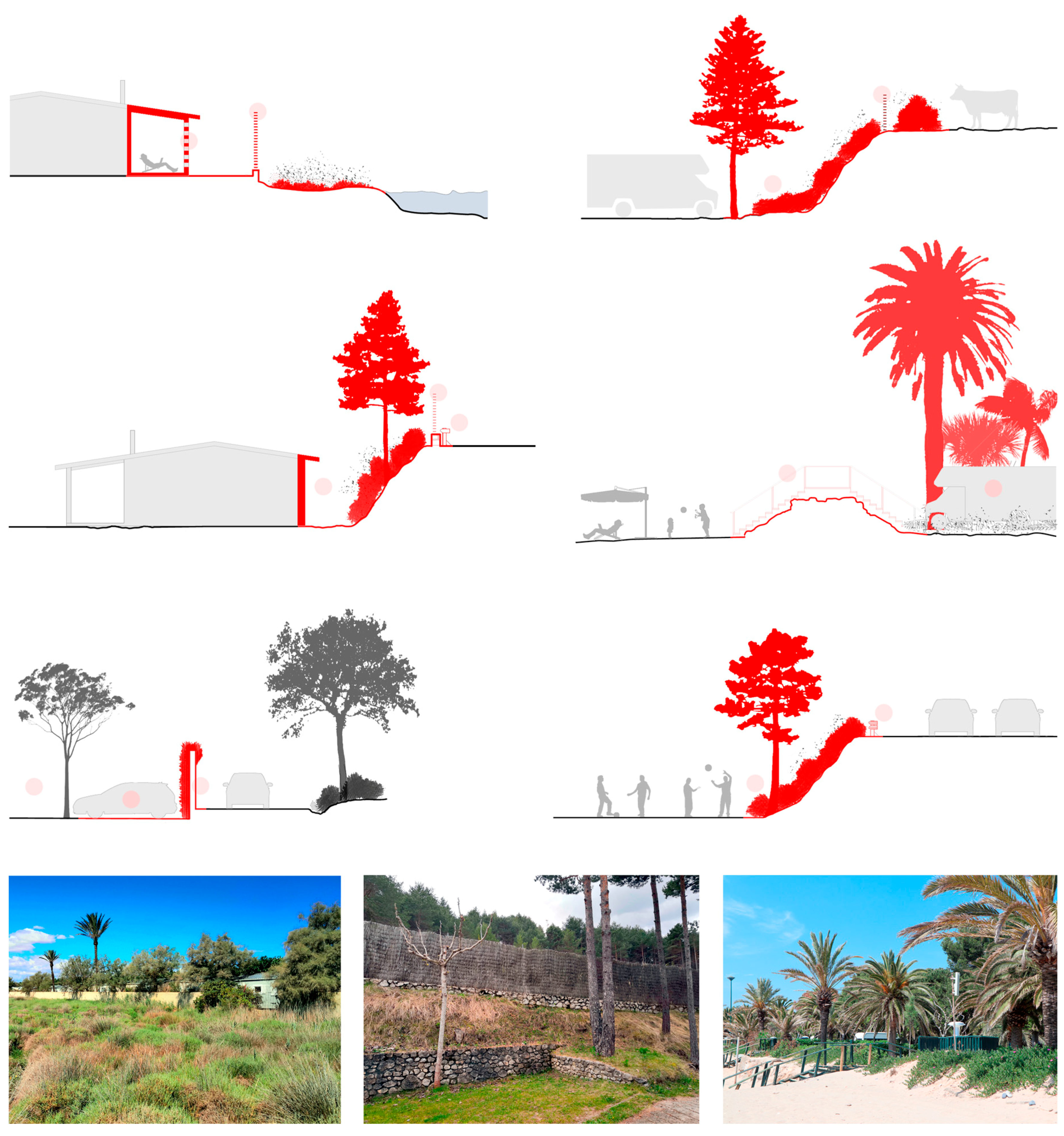
  • Boundaries: the limits of the settlement are identified and drawn, with special emphasis on their dimensions (linear, thick strip, and height), filters (single element or several layers), materiality (natural or artificial) and performance (transparency, unevenness and safety) [75].
  • Road hierarchy: the structure of the settlement is defined by means of its road hierarchy, differentiating between the main roads (vehicular traffic, buildings and open spaces links), the secondary ones (access to plots) and the shortcuts (pedestrian and direct connections) [76].
  • Open spaces: sectors free of buildings and destined for shared outdoor activities are identified and classified considering their typology (squares, equipped axes, playgrounds and sports areas) [77].
  • Lodging: the different lodging typologies are registered, basically itinerant plots (tents and caravans) and stable modules (bungalows, mobile-homes and glamping), with a special emphasis on the way these accommodations are grouped and on the territorial depth they generate between the public and private domains [78].

4.3. Comparative Analysis

4.3.1. Working Scales

Once the first fieldwork visits have been made and the documentary information received has been recorded, the comparative analysis of the different case studies begins. The objective of this phase is to identify which aspects are most relevant to develop a landscape integration diagnosis and to define the criteria for it to be replicable in other cases within the geographical framework.
The comparative analysis begins with the specification of the working scales, to later elaborate the thematic maps from the diagrams made in the fieldwork. Considering that this research is governed by some of the determinations set out in the “Good Practices Manual. Architectural Actions in Campsites”, the working scales defined on it are replicated in the diagnosis to coherently relate the possible improvements with the good practices developed in the manual. Thus, the diagnosis is structured in the following approach levels, each one related to a working scale.
  • Enclosure: it expands on the relationship between the settlement and the landscape at a territorial scale.
  • Layout: it develops the internal structure of the campsite at a settlement scale.
  • Clusters: it outlines the potential display of elements and uses at the settlement at a neighborhood scale.
  • Pavilions: it explores the common buildings’ architectural and constructive typology at a building scale.
  • Artifacts: it deals with the individual adaptation of users in the accommodation at a dwelling scale.

4.3.2. Settlement Configuration

At the upper scale, that of the Enclosure, the working documents are those related to masterplans, territorial mapping and Landscape Catalogs. These documents reflect the relationship of the settlement with the territory and highlight its main potentials to favor landscape integration (Figure 5). At this level, the evolution of the settlement over time is also deeply studied, through historical and current photographs and aerial flights.
In the other four approach levels, Layout, Clusters, Pavilions and Artifacts, the settlements are analyzed as projected entities, with their structure and characteristics defined from the architecture to enhance their belonging to their immediate context. In this phase, the comparative analysis is based on the mapping of the case studies, by means of simple and intelligible diagrams [79]. Each map is thematic and focuses exclusively on one aspect of the analysis [80]. In this way, the comparison between the equivalent diagrams facilitates the recognition of the common situations in the different study cases, as well as the singularities to adapt the settlement to its specific environment (Table 3) [81].
Some of the relevant aspects identified in the case studies are: the clear relationship between the main roads and the layout of the common buildings to minimize the paved surfaces; the zoning of the larger campsites in several sectors with defined configurations; the grouping of leisure activities near the access and reception to encourage their use by the general public; the release of some perimeter areas for undefined uses (games, sports); and the regularity of the internal structure which in some cases does not conform to the original patterns of the landscape (plots, hydrography and roads).

4.3.3. Boundaries Definition

One of the most relevant aspects to analyze the landscape integration of a campsite in its environment is the limits that define the enclosure [82]. The diagnosis places special emphasis on these perimeter fringes because both the perception of the campsite from the outside and the immersion of users from the inside towards the surrounding landscape depend on them [83].
This diagnosis recognizes the boundaries more as complex fringes than as single linear elements, despite of the configuration of the boundaries is highly variable and depends both on the sensitivity of the campsite managers and the physical conditions of the site. In any case, these elements remain in place, even during periods of inactivity or when there are no accommodations occupying the plots. Therefore, proper boundary design is essential to ensure the sitting of the campsite in the natural environment.
The analysis at this scale of work, linked to the upper level of the Enclosure, is developed by means of section diagrams of all the boundary typologies that each enclosure has (Figure 6). These documents provide a higher level of detail than the thematic maps, with the aim of being able to reflect on the perception of users in relation to these elements (privacy, security, comfort), as well as on the more constructive aspects (dimensions, materiality and filters).
The indicators or parameters considered at this level are: the thickness of the boundary fringe (number of filters, depth and linked free spaces); the separation by natural elements (vegetation, hydrography and unevenness); the capacity to offer visuals through (permeability, transparency, lattices and landmarks); and the activities on both sides of the boundary (uses, constructions, hourly dynamics and noise). In each case study, the boundaries are classified by typology according to their configuration and a graphic legend is elaborated to recognize the composition and homogeneity of the perimeter, which is why each section diagram also includes a photograph from the outside and another from the inside. The set of these documents eases the comparison between the systems used in each campground, as well as the criteria applied for adaptation to the environment.
In this sense, some of the most relevant aspects identified in the comparative analysis are: the use of areas free of buildings to favor separation by distance through natural strips (neighboring plots, lagoons, torrents and crop fields); the recognition of the existing topography to ensure privacy and protection at different levels (stone walls, vegetation slopes and buried buildings); the arrangement of buildings in the more consolidated perimeters to favor activities shared with the exterior (restaurant and sports activities); the introduction of native and varied vegetation that acts as a natural filter that changes throughout the year (flowering, aromas and monumental trees); and the use of continuous linear elements that do not favor the integrating vision of the whole (isolated walls, fences and formal hedges).

5. Discussion

The process detailed in the previous sections constitutes a work methodology in itself, and the aim of this research [84]. Its singularities lie in the fact that it is defined from the fieldwork, that it contemplates a precise reading of landscape values of the site considering campsite seasons, that the scope is not based on the environmental management but specifically on the architectural design strategies, and that it basically considers the commonly accessible data by this tourism typology. Research adopts this method to be replicable in the diagnosis of landscape integration of similar case studies.
As such, the next step in the research consists of concluding the comparative analysis and synthesis of the results obtained in the different diagnoses carried out in the case studies. Once again, the comparison and detection of needs for each of the cases makes it possible to prepare a documentary tool that collects step by step the different processes described. This application is the diagnosis sheet and consists of a form that serves as a basic template and methodological guide. The form lead both the recording of data during the fieldwork phase and the final presentation of the documentation elaborated in a report format.
The objective of the sheet is to become an accessible and easy-to-use tool for technicians (architects, landscape architects and urban planners) and settlement managers. It should therefore be based on a versatile platform (text and image) and be widely used. With these premises, it has been decided to elaborate a digital document, designed using an open-source text editor, which can be easily exported to other editors or viewers according to the needs of each drafting team.
For the layout, the DinA4 vertical format was chosen as it is an easily printable document, with adequate dimensions for data collection in the fieldwork and can be displayed correctly on most mobile devices. As for the content to be inserted, it is standardized for each section and consists of specific data (dates, areas, units…), multiple selection options (checkboxes), single selection options (drop-down list), descriptions (synthetic or elaborated descriptions) and graphics (photographs, plans and diagrams).
The organization of the information is based on the working scales defined in the comparative analysis: Enclosure, Layout, Clusters, Pavilions and Artifacts. Thus, the file is structured in six sections: an initial one that includes general data and five with the content elaborated in the study, one for each approach level. Likewise, each section is divided into different categories defined in the reference manual, and this allows the diagnosis to be guided and to go deeper into the most representative issues of each settlement. The aspects analyzed in each approach level and categories are distributed in a total of 25 pages according to the structure detailed in Table 4.
At the end of each section a box is reserved for the specific conclusions of that level of approach. The diagnosis of landscape integration should not only analyze and identify the situation of each campsite with respect to its implantation in the site but should also objectively assess whether this relationship is adequate and even propose possible solutions for those aspects that are not. In this sense, it should be noted that the diagnosis is not the tool to resolve any anomalies detected in each settlement; that function corresponds to other design works such as landscape projects or masterplans. However, the diagnosis does make it possible to suggest possibilities for improvement, at the level of project strategies, which are formulated on the basis of the numerous good practices described in the aforementioned manual [28,29,85].
For instance, regarding he Artifacts approach level, several of the case studies analyzed include formal linear boundaries between camping plots (low walls and formal bushes). These elements generate a regular, small-grained mesh that normally does not form part of the landscape’s identity patterns and, in addition, fragments the shared natural space, minimizing its flexible public use. In view of these detected conditions, and based on the reference manual, the following recommendations are provided as good practices:
E.1.2_Artifacts/Plots/Delimitation: Promote the management of plots without formal delimitations. Avoid fragmentation of the free areas of occupation. Recognize unoccupied plots as part of the system of shared open spaces. Maintain continuity between plots and roads, with diffuse paving and vegetation cover. Promote the use of varied and free-growing native vegetation.
In addition, another singular aspect of the diagnosis sheet is that its design arises from the comparative analysis of the case studies. It is based on the synthesis of the information worked on and on the detection of the problems that occurred in the previous phases of fieldwork and graphic recording. To ensure correct implementation by stakeholders (managers, architects, Administration), all fillable boxes include a brief description of the type of information to be contained in that section and how it should be entered. As a result of this process, the following series of common criteria have been established to efficiently elaborate the diagnosis of the settlements.
On the one hand, the structure by approach levels has been coherently defined as detailed above. On the other one, a series of graphic guidelines have also been determined for the elaboration of plans, maps and diagrams in a unitary manner (Figure 7, Template S1). The sheet indicates which type of graphic corresponds to each box, scale and dimensions of the drawing, the line value and the color palette. The use of these common criteria makes it possible to compare the results of all the diagnoses carried out in the geographical scope of the research, and thus promote decision-making not only at the level of the settlement by its manager, but also at the territorial scale by the administration [86].

6. Conclusions

The results obtained in this research are both the diagnosis report of each one of the case studies and the methodology and template for reproducing this diagnosis following established guidelines. Based on these results and feedback from stakeholders, the selected sample of case studies has offered a reliable holistic view of the landscape conditions of the campsite sector in Catalonia. Therefore, the comparative analysis, the definition of common criteria and the generic diagnosis sheet, due to the systematic way in which they have been elaborated, constitute an adequate working basis that can be replicated to the rest of the campsites in Catalunya an to other similar regions.
However, it is important to emphasize that both the method and the diagnosis sheet are two living processes and are designed with sufficient flexibility to be so. As in previous research carried out with this inductive methodology, the generic strategies are elaborated from paradigmatic case studies chosen with criteria consistent with the research, but each campsite and each landscape are unique and new studies can provide new casuistries. For this reason, the systematic application of the diagnostic process in new studies should be able to slightly adapt this work base to include the new conditions, as long as this is properly documented. For this reason, it is considered that the use of this diagnostic guideline should be accompanied by a programmed follow-up, in order to facilitate its application to all the situations that may appear throughout the territory.
In relation to the diagnosis methodology developed in this research, it can be a useful guide for the elaboration of this type of studies since it unifies the criteria and needs of the sector to obtain reliable and comparable data. In this sense, the diagnosis sheet becomes an accessible and easy-to-use tool for technicians, campsite managers and the Administration. Its structure, format and graphic design offer a suitable interface for its various applications. The sheet works as a methodological guideline during the fieldwork and analysis phases, as a proposal roadmap to introduce improvements to the sector, and as a tool for decision-making at a higher scale as it is directly comparable with other similar cases.
In a future publication it is expected to show the results of the application of this methodology to a wider sample of settlements. At the moment, an awareness campaign is being carried out in Catalonia to improve the landscape integration of campsites, in relation to the aspects defined by the PDUAC regulation of 2021. In this sense, all the campsites members of the Catalan Federation of Campsites have a copy of the Manual of Good Practices, as well as the town councils of municipalities with federated campsites, the Department of Territory and Sustainability of Catalonia and the libraries of the Catalan schools of architecture. With the aim of replicating this practice to other environments outside the scope of Catalonia, the English translation of the reference manual is also being promoted.
Although the current research has focused on rural cultural landscapes, 13% of campsites in Catalonia are located in urban environments [24]. In a future phase of this research, this type of settlements will be addressed in order to integrate the conditioning factors of urban areas into the methodology developed and thus enhance the territorial vision of the sector in terms of landscape integration. Precisely, one of the problems of campsites located in urban environments is their difficult insertion into the built fabric and local dynamics [87]. However, due to their unitary management and their vocation for the use of nature and shared free space, these sectors can become urban regenerators for the re-naturalization of free spaces, the production of renewable energy, water management or the integration of social and cultural dynamics [88].
In a general view, as a result of the analysis of case studies the evolution of the sector from its origins in the 1950s in Catalonia to the present day in relation to settlement configuration has been identified and confirmed [89]. From the maximum density of accommodation in the 2000s, nowadays new masterplans or extensions of campsites are being promoted to increase the size of the plots, thus decreasing the density and favoring the comfort and contact of users with nature [90]. In addition, these projects usually include a high rate of semi-mobile lodgings following tourism demands, which adds a relevant need of landscape integration actions. This research and the diagnosis methodology resulted might be suitable to define an adequate way of assessing existing conditions or new proposals for campsite regeneration.
In a future phase of development of this research, the elaboration of a synthesis sheet of the diagnosis is foreseen. This document will make it possible to visualize the main results of the study in a summarized format and focused on the conclusions and possibilities for improvement at each of the approach levels. From the different local administrations consulted, this new step is considered fundamental so that the results of the diagnosis can be efficiently considered in the urban planning processes. In addition, the regular updating of these studies over time, every five or ten years, would make it possible to clarify the evolution of the settlement in relation to its context and to recognize whether the improvements applied have favored landscape integration in the long term. This is a similar process to the one already stablished by the Catalan Government to prevent and control the obsolescence of the building stock [91].
Finally, another possible aspect to implement in the diagnosis sheet is the quantitative evaluation of the degree of landscape integration detected for each level of approach. Together with the conclusions and possibilities for improvement, obtaining this evaluative data would make it possible to establish minimum standards to be met in these settlements. The will is not so much to develop a regulatory approach, but an incentive one. This method already occurs both in the tourist sector with the Ecolabels aforementioned, and in the building sector with the Eco-efficiency Decree or the Energy Performance Certificate [92,93]. Those campsites whose assessment of the diagnosis is favorable should be eligible for commercial upgrades (quality seal of landscape integration), economic grants (tax rebates and subsidies for the implementation of improvements) or other benefits to promote the preservation of the identity values of the cultural landscapes of our territory.

Supplementary Materials

The following supporting information can be downloaded at: https://www.mdpi.com/article/10.3390/land11030365/s1, Template S1: Diagnosis Sheet_template.

Author Contributions

Conceptualization, A.M., X.M. and J.G.; methodology, A.M., X.M. and J.G.; formal analysis, A.M., X.M. and J.G.; visualization, X.M.; writing—original draft preparation, X.M.; writing—review and editing, A.M., X.M. and J.G. All authors have read and agreed to the published version of the manuscript.

Funding

This research project was funded by Ramon Llull University with funds provided by Fundació “la Caixa”, grant number 2020-URL-IR2nQ-021.

Institutional Review Board Statement

Not applicable.

Informed Consent Statement

Not applicable.

Data Availability Statement

Not applicable.

Acknowledgments

The authors would like to express their gratitude to the stakeholders that participated in this study and contributed with their valuable insights, and especially to the Federació Catalana de Càmpings and the campsites which took part in the research as case studies.

Conflicts of Interest

The authors declare no conflict of interest. The funders had no role in the design of the study; in the collection, analyses, or interpretation of data; in the writing of the manuscript, or in the decision to publish the results.

References

  1. Garay, L.; Cánoves, G. Life cycles, stages and tourism history: The Catalonia (Spain) experience. Ann. Tour. Res. 2011, 38, 651–671. [Google Scholar] [CrossRef]
  2. Tatjer, M. En los orígenes del turismo litoral: Los baños de mar y los balnearios marítimos en Cataluña. Scr. Nova Rev. Electrón. De Geogr. Y Cienc. Soc. 2009, 13. Available online: https://raco.cat/index.php/ScriptaNova/article/view/218576 (accessed on 25 March 2021).
  3. Tyrakowski, K. The role of tourism in land utilization conflicts on the Spanish Mediterranean coast. GeoJournal 1986, 13, 19–26. [Google Scholar] [CrossRef]
  4. Bellmunt, J. Litoral. In Landscape; Colafranceschi, D., Ed.; Gustavo Gili: Barcelona, Spain, 2007; p. 120. [Google Scholar]
  5. Pié, R.; Rosa, C. (Eds.) Un turismo sin arquitectura o una arquitectura sin argumento. In Turismo Líquido; IHTT (UPC): Barcelona, Spain, 2013; p. 7. [Google Scholar]
  6. Feo, F. Los campings en España. Cuad. Tur. 2003, 11, 83–96. Available online: https://dialnet.unirioja.es/servlet/articulo?codigo=753859 (accessed on 16 July 2021).
  7. Cases, M.; Ariño, F. El Camping a Catalunya; Centre Excursionista de Catalunya: Barcelona, Spain, 1924. [Google Scholar]
  8. Miranda, M.J. El camping, la forma más reciente de turismo. Cuad. Geogr. 1985, 37, 157–174. Available online: https://dialnet.unirioja.es/servlet/articulo?codigo=37627 (accessed on 15 July 2021).
  9. The Spanish Government. Royal Decree 2545/82 about Campsite Creation, 27 August 1982. Available online: https://www.boe.es/buscar/doc.php?id=BOE-A-1982-26301 (accessed on 15 July 2021).
  10. Martín, X.; Martínez, A. Arquitecturas del Turismo Informal. El Habitar Lúdico en la Naturaleza; Asimétricas: Madrid, Spain, 2020. [Google Scholar]
  11. Simpson, D. Young-Old. Urban Utopias of an Aging Society; Lars Muller: Baden, Switzerland, 2014. [Google Scholar]
  12. Barba, R. Les peces mínimes del turisme. In Debat Urbanístic Sobre la Costa Brava; Coromines, E., Sola, P., Eds.; COAC: Girona, Spain, 2003; pp. 71–79. [Google Scholar]
  13. Martínez, A.; Martín, X.; Gordon, J. Matrix of Architectural Solutions for the Conflict between Transport Infrastructures, Landscape and Urban Habitat along the Mediterranean Coastline: The Case of the Maresme Region in Barcelona, Spain. Int. J. Environ. Res. Public Health 2021, 18, 9750. [Google Scholar] [CrossRef]
  14. Martín, X. Architecture for Informal Tourism-Mild Occupation of Landscape through Campsites. Athens J. Tour. 2015, 2, 4. [Google Scholar] [CrossRef]
  15. Farrell, T.; Hall, T.; White, D. Wilderness campers’ perception and evaluation of campsite impacts. J. Leis. Res. 2001, 33, 229–250. [Google Scholar] [CrossRef]
  16. EU Eco-Management and Audit Scheme (EMAS). Available online: https://ec.europa.eu/environment/emas/index_en.htm (accessed on 11 February 2022).
  17. European Ecolabel for Tourist Accommodation (EU Ecolabel). Available online: https://ec.europa.eu/environment/ecolabel/index_en.htm (accessed on 12 February 2022).
  18. Green Globe. Available online: https://www.greenglobe.com/ (accessed on 18 February 2022).
  19. ISO 14001 Family, Environmental Management. Available online: https://www.iso.org/iso-14001-environmental-management.html (accessed on 6 June 2021).
  20. Voluntary Initiatives for Sustainability in Tourism (VISIT). Available online: http://www.visit21.net/ (accessed on 22 February 2022).
  21. Biosphere Camping Certification. Available online: https://www.biospheretourism.com/en/biospherecamping-certification/98 (accessed on 12 December 2021).
  22. Jiménez, E. El turismo y los modos de transporte. In Turismo Líquido; Pié, R., Rosa, C., Eds.; IHTT (UPC): Barcelona, Spain, 2013. [Google Scholar]
  23. Catalan Campsite Federation. Available online: www.campingsdecatalunya.org (accessed on 10 January 2022).
  24. Calabuig, J. Llibre Blanc del Sector del Càmping a Catalunya. Anàlisi de L’activitat, Tendències i Reptes de Futur; EURECAT: Reus, Spain; Tarragona, Spain, 2019; Available online: https://www.campingsdecatalunya.org/wp-content/uploads/llibre-blanc-campings-catalunya-doc-sintesi.pdf (accessed on 2 January 2022).
  25. Begur Campsite (Begur, Girona Region, Spain). Available online: https://campingbegur.com/our-philosophy/?lang=en (accessed on 21 February 2022).
  26. La Ballena Alegre Campsite (Sant Pere Pescador, Girona Region, Spain). Available online: https://www.ballena-alegre.com/en/news/best-sustainable-campsite-in-europe/ (accessed on 21 February 2022).
  27. Campsites Association in Girona, Press Release, January 2022. Available online: https://campingsingirona.com/wp-content/uploads/2022/01/Dossier-de-premsa-ACG_Cat.pdf (accessed on 13 February 2022).
  28. Martín, X.; Martínez, A. Manual de Bones Pràctiques. Accions Arquitectòniques en els Càmpings [Good Practices Manual. Architectural Actions in Campsites]; La Salle-URL: Barcelona, Spain, 2019. [Google Scholar]
  29. Martín, X.; Martínez, A.; de Rentería, I. The Integration of Campsites in Cultural Landscapes: Architectural Actions on the Catalan Coast, Spain. Sustainability 2020, 12, 6499. [Google Scholar] [CrossRef]
  30. Taylor, K. Landscape and meaning: Context for a global discourse on cultural landscape values. In Managing Cultural Landscapes; Routledge, Taylor & Francis Group: Oxfordshire, UK, 2012; Available online: http://hdl.handle.net/1885/59693 (accessed on 11 December 2021).
  31. Díaz, P. Transformación y urbanización del frente costero español. In Turismo Líquido; Pié, R., Rosa, C., Eds.; IHTT (UPC): Barcelona, Spain, 2013; pp. 190–203. [Google Scholar]
  32. Gómez-Martín, M. Climate potential and tourist demand in Catalonia (Spain) during the summer season. Clim. Res. 2006, 32, 75–87. [Google Scholar] [CrossRef]
  33. Garay, L.; Cànoves, G. El desarrollo turístico en Cataluña en los dos últimos siglos: Una perspectiva transversal. Doc. D’anàlisi Geogràfica 2009, 53, 29–46. Available online: https://ddd.uab.cat/record/36406 (accessed on 23 January 2022).
  34. Farina, A. The cultural landscape as a model for the integration of ecology and economics. BioScience 2000, 50, 313–320. [Google Scholar] [CrossRef] [Green Version]
  35. Rosa, C. El Turismo como futuro: La ciudad del ocio. In Turismo Líquido; Pié, R., Rosa, C., Eds.; IHTT (UPC): Barcelona, Spain, 2013; pp. 38–49. [Google Scholar]
  36. VVAA. El turismo en la costa I. Cuad. Arquit. 1966, 64, 3. [Google Scholar]
  37. Izquierdo i Molinas, S. Els orígens del càmping com a activitat turística a Catalunya. Treballs de la Societat Catalana de Geografia 2002, 53–54, 99–124. Available online: https://www.raco.cat/index.php/TreballsSCGeografia/article/download/203199/271556 (accessed on 5 December 2021).
  38. Allgemeiner Deutscher Automobil-Club (ADAC). Available online: https://www.adac.de/ (accessed on 22 February 2022).
  39. Royal Dutch Touring Club (ANWB). Available online: https://www.anwb.nl/ (accessed on 22 February 2022).
  40. Alan Rogers Guide. Available online: https://alanrogers.com/ (accessed on 22 February 2022).
  41. Mediterranean Campsite Confederation. Available online: https://campingsdelmediterraneo.org/ (accessed on 15 October 2021).
  42. VVAA. Catàlegs de Paisatge de Catalunya; Observatori del Paisatge: Barcelona, Spain, 2019. [Google Scholar]
  43. The Catalan Government. Pla Director Urbanístic del Sistema Costaner (PDUSC), Regulatory DOGC 6722. Available online: https://portaldogc.gencat.cat/utilsEADOP/PDF/6722/1374519.pdf (accessed on 18 May 2021).
  44. The Catalan Government. Pla d’Espais d’Interès Natural (PEIN), Regulatory Decret 328/1992. Available online: http://sig.gencat.cat/visors/enaturals.html (accessed on 18 May 2021).
  45. The Catalan Government. Urban Master Plan for Camping Activities (PDUAC). Available online: http://territori.gencat.cat/ca/06_territori_i_urbanisme/planejament_urbanistic/pla_director_urbanistic_pdu/en_curs/Catalunya/pdu_campings/index.html (accessed on 22 January 2022).
  46. Nogué, J.; Wilbrand, S. Landscape identities in Catalonia. Landsc. Res. 2018, 43, 443–454. [Google Scholar] [CrossRef]
  47. Martínez, A.; Rueda, C.; Gordon, J.; Ospina, J. Estratègies per a la Regeneració Sostenible d’assentaments Turístics a la Costa Mediterrània. In V Seminario Internacional de Investigación en Urbanismo, Barcelona-Buenos Aires, Junio 2013; Departament d’Urbanisme i Ordenació del Territori, Universitat Politècnica de Catalunya: Barcelona, Spain, 2013; pp. 1280–1292. Available online: http://hdl.handle.net/2099.2/3543 (accessed on 12 November 2021).
  48. The Catalan Government. Decret 75/2020 de Turisme de Catalunya [Catalan Tourism Decree], 4 August 2020. Available online: https://portaldogc.gencat.cat/utilsEADOP/PDF/8195/1886478.pdf (accessed on 18 December 2021).
  49. Girot, C. Identidad. In Landscape + 100 Palabras Para Habitarlo; Colafranceschi, D., Ed.; Gustavo Gili: Barcelona, Spain, 2007. [Google Scholar]
  50. Cuadrado-Ciuraneta, S.; Durà-Guimerà, A.; Salvati, L. Not only tourism: Unravelling suburbanization, second-home expansion and “rural” sprawl in Catalonia, Spain. Urban Geogr. 2017, 38, 66–89. [Google Scholar] [CrossRef]
  51. Lucivero, M. Camping and open-air tourism: An opportunity for sustainable tourism in Coastal Areas. In Proceedings of the 6th Conference of the International Forum on Urbanism (IFoU): TOURBANISM, Barcelona, Spain, 25–27 January 2012; pp. 1–9. Available online: http://hdl.handle.net/2099/12603 (accessed on 3 November 2021).
  52. Hunter, C.; Shaw, J. The ecological footprint as a key indicator of sustainable tourism. Tour. Manag. 2007, 28, 46–57. [Google Scholar] [CrossRef]
  53. Saura, T. El Crecimiento del Turismo de Camping y Caravaning Como una Modalidad Sostenible. Ph.D. Thesis, Ciencias de la Empresa, Universidad Politécnica de Cartagena, Cartagena, Spain, 2021. Available online: http://hdl.handle.net/10317/10232 (accessed on 12 December 2021).
  54. Hailey, C. Camps: A Guide to 21st-Century Space; The MIT Press: Cambridge, MA, USA, 2009. [Google Scholar]
  55. Gustafson-Melka, K. Paysage de Camping; IAURIF: Paris, France, 1981. [Google Scholar]
  56. Cayuelas, A.; García Píriz, T. Arquitectura Ramadera i Paisatge en Transformació; Arquitectes per l’Arquitectura: Barcelona, Spain, 2020; Available online: http://hdl.handle.net/2117/328355 (accessed on 19 June 2021).
  57. Mehrotra, R.; Vera, F. Ephemeral Urbanism: Cities in Constant Flux; Ediciones ARQ Escuela de Arquitectura Pontificia Universidad Católica de Chile: Santiago, Chile, 2016. [Google Scholar]
  58. Gehl, J.; Gemzoe, L. Nuevos Espacios Urbanos; Gustavo Gili: Barcelona, Spain, 2002; pp. 10–21. [Google Scholar]
  59. Francis, M. A case study method for landscape architecture. Landsc. J. 2001, 20, 15–29. [Google Scholar] [CrossRef]
  60. Martínez, A.; Vives, L. Stratégies Méditerranéenes pour la régéneration architectonique du bord de la mer. Classeur. Mare Nostrum 2017, 2, 341. [Google Scholar]
  61. Ferrer, A.; Martínez, A.; Rentería, I.; Terradas, R. Estrategias Mediterráneas; Claret: Barcelona, Spain, 2015; pp. 12–13. [Google Scholar]
  62. Ferrer, A. El dibujo del territorio como forma de conocimiento. In Estrategias Mediterráneas; Claret: Barcelona, Spain, 2015; pp. 80–83. [Google Scholar]
  63. Gordon, J.; Martin, X.; Peguero, A. El trabajo de campo. Instrumento esencial en el proyecto de investigación. In Estrategias Mediterráneas; Claret: Barcelona, Spain, 2015; pp. 100–101. [Google Scholar]
  64. Simonds, J.; Starke, B. Landscape Architecture: A Manual of Environmental Planning and Design; McGraw-Hill: New York, NY, USA, 2013. [Google Scholar]
  65. Stephenson, J. The Cultural Values Model: An integrated approach to values in landscapes. Landsc. Urban Plan. 2008, 84, 127–139. [Google Scholar] [CrossRef]
  66. Nijhuis, S.; Bobbink, I. Design-related research in landscape architecture. J. Des. Res. 2012, 10, 239–257. [Google Scholar] [CrossRef]
  67. Gómez-Sal, A.; Belmontes, J.; Nicolau, J. Assessing landscape values: A proposal for a multidimensional conceptual model. Ecol. Model. 2003, 168, 319–341. [Google Scholar] [CrossRef]
  68. IDESCAT Catalan Institute of Statistics. Available online: https://www.idescat.cat/ (accessed on 12 December 2021).
  69. INE Spanish National Institute of Statistics. Available online: https://www.ine.es/ (accessed on 9 November 2021).
  70. Martín, X. Arquitectura del Turismo Informal. El Camping Como Modelo de Ocupación Temporal en el Litoral Mediterráneo de Catalunya. Ph.D. Thesis, La Salle—Ramon Llull University, Barcelona, Spain, 17 September 2018. [Google Scholar]
  71. Saló, A.; Teixidor, A.; Fluvia, M.; Garriga, A. The effect of different characteristics on campsite pricing: Seasonality, dimension and location effects in a mature destination. J. Outdoor Recreat. Tour. 2020, 29, 100263. [Google Scholar] [CrossRef]
  72. Ma, S.; Craig, C.; Feng, S. The Camping Climate Index (CCI): The development, validation, and application of a camping-sector tourism climate index. Tour. Manag. 2020, 80, 104105. [Google Scholar] [CrossRef]
  73. Brown, G. Mapping landscape values and development preferences: A method for tourism and residential development planning. Int. J. Tour. Res. 2006, 8, 101–113. [Google Scholar] [CrossRef]
  74. Hernández, J. La resonancia del lugar. Arquitectura contemporánea y contexto. In Arquitectura y Ciudad. La Tradición Moderna Entre la Continuidad y la Ruptura; Arte y Estética: Madrid, Spain, 2007; pp. 12–39. [Google Scholar]
  75. Zanini, P. Confín. In Landscape; Colafranceschi, D., Ed.; Gustavo Gili: Barcelona, Spain, 2007; p. 40. [Google Scholar]
  76. Eppell, V.; McClurg, B.; Bunker, J. A four level road hierarchy for network planning and management. In Proceedings of the 20th ARRB Transport Research Conference; ARRB Transport Research Ltd.: Vermont South, Austrilia, 2001; pp. 1–7. [Google Scholar]
  77. Sennett, R. L’espai Públic. Un Sistema Obert, Un Procés Inacabat; Arcàdia: Barcelona, Spain, 2014. [Google Scholar]
  78. Pallasmaa, J. Habitar; Gustavo Gili: Barcelona, Spain, 2016. [Google Scholar]
  79. Bambó, R.; García, M. Mapping urbanism, urban mapping. In Urban Visions; Springer: Cham, Switzerland, 2018; pp. 237–246. [Google Scholar] [CrossRef]
  80. Lynch, K. The Image of the City; MIT Press: Cambridge, MA, USA, 1964. [Google Scholar]
  81. Martínez, A. Restablecer el carácter del lugar. In Estrategias Mediterráneas; Claret: Barcelona, Spain, 2015; pp. 92–95. [Google Scholar]
  82. Loidl, H.; Bernard, S. Open (ing) Spaces: Design as Landscape Architecture; Walter de Gruyter: Berlin, Germany, 2014. [Google Scholar]
  83. Roe, M. Crossing the boundaries? In Exploring the Boundaries of Landscape Architecture; Routledge: London, UK, 2011; pp. 299–310. [Google Scholar]
  84. Gascón, C.; Rovira, T. Pautas de Investigación; Edicions UPC: Barcelona, Spain, 2007. [Google Scholar]
  85. Renteria, I. Intervención en los edificios. In Estrategias Mediterráneas; Claret: Barcelona, Spain, 2015; pp. 102–105. [Google Scholar]
  86. Baidal, J. Regional development policies: An assessment of their evolution and effects on the Spanish tourist model. Tour. Manag. 2003, 24, 655–663. [Google Scholar] [CrossRef]
  87. I Gispert, O.; Clavé, S. Dimensions and models of tourism governance in a tourism system: The experience of Catalonia. J. Destin. Mark. Manag. 2020, 17, 100465. [Google Scholar] [CrossRef]
  88. Breiby, M.; Duedahl, E.; Oian, H.; Ericson, B. Exploring Sustainable Experiences in Tourism. Scand. J. Hosp. Tour. 2020, 20, 1–17. [Google Scholar] [CrossRef] [Green Version]
  89. The Catalan Government. Principals Indicadors de la Demanda del Turisme de Càmping a Catalunya; Catalan Campsites Fed.: Girona, Spain, 2019.
  90. Consell de Redacció, T.A.G. El sector del càmping reivindica la importància de la rehabilitació i la renovació constant dels equipaments. TAG-Rev. Inst. Del Col· Legi D’aparelladors Arquit. Tècnics I Eng. D’edificació De Tarrag. 2020, 87, 11–13. Available online: https://www.raco.cat/index.php/TAG/article/download/364014/458336 (accessed on 23 January 2021).
  91. The Catalan Government. Inspecció Tècnica dels Edificis (ITE) [Technical Building Inspection]. Available online: https://habitatge.gencat.cat/ca/ambits/preguntes-frequents/inspeccio-tecnica-dedificis-ite/ (accessed on 7 January 2022).
  92. The Catalan Government. Decret d’Eco-eficiència de Catalunya [Catalan Eco-Efficiency Decree]. 2006. Available online: https://www20.gencat.cat/docs/arc/Home/Consultes%20i%20tramits/Normativa/Normativa%20catalana%20en%20materia%20de%20residus/decret_21_2006.pdf (accessed on 17 December 2021).
  93. The Catalan Government. Certificat d’Eficiència Energètica dels Edificis (CEE) [Energy Performance Certificate (EPC)]. Available online: http://icaen.gencat.cat/ca/energia/usos_energia/edificis/certificacio (accessed on 7 January 2022).
Figure 1. Location of the selected case studies and distribution of campsite associations in Catalonia (Source: authors’ own). (A) Campsite Les Medes; (B) Campsite Castell Mar; (C) Campsite Torre del Sol; (D) Campsite Pla de Mar; (E) Campsite Verneda; (F) Campsite Repòs Pedraforca.
Land 11 00365 g001
Figure 2. Identification and selection of eligible case studies, according to the variables considered in relation to the landscape, the settlement, and its activity. Selected case studies are highlighted and in bold type. Categories are identified by levels and stars: **, ***, **** (Source: authors’ own).
Land 11 00365 g002
Figure 3. Comparative analysis of the information collected for each case study. Common and most relevant documents for the study are highlighted in bold type (Source: authors’ own).
Land 11 00365 g003
Figure 4. Sample of schemes and diagrams made in the fieldwork during on-site data collection (Source: authors’ own). (A) Road hierarchy (PM); (B) Buildings and open spaces (PM); (C) Boundaries in ground floor and section (PM); (D) Reading of the place (LM).
Land 11 00365 g004
Figure 5. Location plans and landscape values. Scale 1/5000, DinA3, vertical north (Source: authors’ own). (A) Campsite Les Medes; (B) Campsite Castell Mar; (C) Campsite Torre del Sol; (D) Campsite Pla de Mar; (E) Campsite Verneda; (F) Campsite Repòs Pedraforca.
Land 11 00365 g005
Figure 6. Sample of boundaries typologies defined in section diagrams. Elements in red are considered part of the limit fringe and circles highlight identified conflicts (Source: authors’ own).
Land 11 00365 g006
Figure 7. Sample of some pages of the diagnosis sheet: base template in the top row and complete diagnosis report in the bottom row (Source: authors’ own). The complete template is available in the Supplementary Materials (Template S1).
Land 11 00365 g007
Table 1. Research process based on “Mediterranean Strategies” inductive methodology.
MethodologyCase Study StageApplication Stage
Analysis(1) Identification and selection(5) Form structure definition
Fieldwork(2) Site visits and data collection(6) Form test and review
Comparative approach(3) Drawing at different scales(7) Common graphic criteria
Reflections and conclusions(4) Working scales setting(8) Template elaboration
Land 11 00365 i001
Table 2. Identification of selected case studies.
Case StudyLes Medes
(LM)
Castell Mar
(CM)
Torre del Sol
(TS)
Pla de Mar 1
(PM)
Verneda
(VN)
Repòs Pedraforca
(RP)
AssociationACG
(Girona)
ACG
(Girona)
ACT
(Tarragona)
ACB
(Barcelona)
ACL
(Lleida)
ACM
(Mountain)
Landscape
Unit
Empordanet—Baix TerPlana de
l’Empordà
Plana de
l’H. de l’Infant
Baixa TorderaEra Baisha—
Val d’Aran
Capçaleres del Llobregat
Landscape valuesCrops,
protected area,
landmark
Marshes,
protected area,
pet friendly
Large settlement,
topography, beach contact
Three unified
settlements,
beach contact
River,
mountain valley, snowy winter
New extension,
topography,
landmark
Aerial view Land 11 00365 i002 Land 11 00365 i003 Land 11 00365 i004 Land 11 00365 i005 Land 11 00365 i006 Land 11 00365 i007
1 This case study includes three adjacent campsites: El Pla de Mar, Del Mar and La Conca.
Table 3. Sample of comparative analysis by means of thematic mapping (Source: authors’ own).
Case StudyHierarchyOpen SpacesLandmarks
Les Medes
(LM)
Land 11 00365 i008 Land 11 00365 i009 Land 11 00365 i010
Castell Mar
(CM)
Land 11 00365 i011 Land 11 00365 i012 Land 11 00365 i013
Torre del Sol
(TS)
Land 11 00365 i014 Land 11 00365 i015 Land 11 00365 i016
Pla de Mar
(PM)
Land 11 00365 i017 Land 11 00365 i018 Land 11 00365 i019
Verneda
(VN)
Land 11 00365 i020 Land 11 00365 i021 Land 11 00365 i022
Repòs Pedraforca
(RP)
Land 11 00365 i023 Land 11 00365 i024 Land 11 00365 i025
Table 4. Structure of the diagnosis sheet by approach levels and categories. Numbers indicate the amount of elements recorded in each section according to content typology (Source: authors’ own).
Working ScaleApproach LevelCategoriesDataMultiple ChoiceSingle ChoiceTextPictureDrawing
-GeneralCampsite,
Owner,
Technician,
Map
Urbanism,
Activity
30----1
LandscapeEnclosureContext,
Access,
Boundaries
-4269 *5 *
SettlementLayoutRoads,
Free spaces,
Landmarks
-3-66 *3 *
SettlementClustersUpper order,
Lodgings,
Common buildings
13-33 *3 *
BuildingPavilionsArchitecture---1 *1 *-
UserArtifactsPlots,
Itinerant,
Permanent
---3 *3 *1
-ConclusionsRating,
Conclusion,
Improvements
--1 **3 **--
* It can be more, minimum one data for each analyzed element. ** For each approach level.
Publisher’s Note: MDPI stays neutral with regard to jurisdictional claims in published maps and institutional affiliations.

