Article

Evaluation of the Health Promotion Capabilities of Greenway Trails: A Case Study in Hangzhou, China

School of Landscape Architecture, Zhejiang A&F University, Hangzhou 311300, China
*
Author to whom correspondence should be addressed.
These authors contributed equally to this work.
Land 2022, 11(4), 547; https://doi.org/10.3390/land11040547
Submission received: 26 February 2022 / Revised: 1 April 2022 / Accepted: 6 April 2022 / Published: 8 April 2022
(This article belongs to the Topic Bioclimatic Designs to Enhance Urban/Rural Resilience)

Abstract

:
As a type of green infrastructure, greenways are beneficial for walking and cycling and promote urban health and well-being. Taking the Qingshan Lake Greenway Phase One (QLG-I) Trail in the Lin’an District of Hangzhou city as an example and based on the accessibility of points of interest (POI) near the QLG-I Trail, a questionnaire investigation, and an importance performance analysis (IPA), in this paper, we construct a methodological framework to evaluate the health-promotion capabilities of the QLG-I Trail, including three aspects: promoting the coverage of healthy travel, user attribute analysis, and user perceptions of the greenway for health promotion. The results show that the healthy travel range of the QLG-I Trail is small and that the users are mainly residents of nearby communities. Additionally, the main factors affecting users’ health-promoting behaviour are safety, cleanliness, and infrastructure services. Although the overall satisfaction with service quality was good (3.93), we found that the trail facilities did not meet the needs of the users. This study confirms that the QLG-I Trail provides community residents with a place for sports activities and supports health-promoting behaviour. Greenway facilities and the natural environment enhance this utility; however, promoting the coverage of healthy travel is limited by accessibility. Finally, we propose a traffic-organization optimization and improvement plan for the QLG-I Trail. The research results may help promote healthy activities on this type of greenway.

1. Introduction

Health promotion is a key element of new public health. Health promotion includes actions aimed at not only strengthening personal skills and abilities but also changing the social, environmental, and economic determinants of health to optimize their positive impact on public and personal health [1]. In this regard, the greenway trail presents an example. Under normal circumstances, a trail refers to any linear corridor that provides non-motorized access for entertainment, and it can take various forms [2]. Compared with other green open spaces, greenway trails have unique linear characteristics and connection attributes [3].
By supporting non-motorized transportation, such as walking and cycling, they provide safe and easy-to-access green spaces or facilities, making them a community health promotion programme [4,5,6]. As green infrastructures, greenways and trails not only provide people with a healthier way to travel but also produce many health-promoting benefits. For example, they increase physical activity [7], alleviate mental stress, and provide opportunities for relaxation and family reunification [8]. In terms of serving the community and its environment [9], greenway trails have a significant health-promotion-service function, and they are becoming increasingly popular all over the world [10].
In recent years, research on greenways and trails has become a hot topic in the fields of ecosystem services supply and demand [11,12,13], green infrastructure [14], and urban non-motorized transportation [15]. Such research has mostly focused on the commercial economy [16], ecosystem supply [17,18,19], regional culture [20], health and well-being [21], and entertainment value [22] brought by urban greenways and trails. Regarding the research on greenways and people’s physical and mental health, natural experiments [23] and health-perception-assessment scales [24] have been used to prove whether there is a link between green scape and human health or to investigate the physical activity of users to explore the health-promotion-service functions of greenways and trails [25]. These research results have confirmed that greenways and their environments have a positive effect on human health.
However, regarding the main beneficiaries of the greenway health promotion function, i.e., greenway users, it is necessary to explore their cognition and evaluation of this function. At the same time, obtaining real feedback on the use of greenways in a timely manner facilitates greenway builders in implementing bottom-up updates and improvements in health promotion. However, the current research on country greenways in this area is still relatively lacking.
Taking into account this gap and based on existing research on the ecological, social and economic performance evaluation of the Qingshan Lake Greenway (QLG), we focus our follow-up research [26] on the evaluation of the health promotion services of greenways. The QLG is a coastal greenway located in the Lin’an District in Hangzhou city. It is an important regional green infrastructure built by the government. Since its completion in 2017, it has become an important place for leisure activities for the surrounding residents.
In this article, we continue to use the QLG as the research object. Based on the connectivity and linear characteristics of the greenway, we evaluate the health promotion services that it provides and make suggestions to improve the health-promotion-service capabilities of country greenways. This research can also serve as a reference for the construction of similar greenways in China and even around the world.
We mainly provide answers to the following research questions: (1) How large must the service area of the greenway trail be to promote healthy travel? (2) Who are the users of the greenway trail? What health-promoting behaviours do users engage in on the greenway? (3) What do trail users think are the greenway factors that affect the promotion of healthy behaviours? (4) How satisfied are users with the attributes of the greenway trail that provide health promotion services? Before introducing the research methods, this article reviews the literature on greenway trails and performance-evaluation methods. This literature review is followed by the results of the case study, the discussion, and the conclusion.

2. Literature Review

A large number of studies have shown that greenway trails provide the basis for important daily fitness activities for the surrounding residents. Price et al. analysed the demographic characteristics of greenway users, the reasons for using the Swamp Rabbit Trail, and the perception of the characteristics of the trail through online surveys, and they found that the greenway increased the opportunities for nearby residents to exercise [7]. Although greenway facilities have great potential to support sports activities, their use can be affected by the accessibility of the area around the greenway [4]. In particular, the demand for walking is often affected by the attractiveness, comfort, safety, and accessibility [27]. Studies have used global positioning system (GPS) and geographical information system (GIS) technologies to predict the degree of use of greenways by measuring their accessibility, proximity, and opportunities [4].
Open digital map platforms, such as Google Maps, provide a new way to directly obtain travel cost indicators. They have been applied for urban traffic accessibility analysis [28]; however, they have been less used for greenway trail accessibility analysis. Walking and cycling are considered to be among the healthiest ways to travel [29], and the optimal amount of time that it should take residents to walk from their homes to city parks is within 15 min [30].
A survey in London also showed that the size, shape, and density of green spaces affect walking activities. Parks near small parks or retail areas are significantly related to walking [31]. Therefore, we take the entrance of the first phase of the QLG Trail as the origin and take the area covered by 15 min (inclusive) of walking or cycling as the service scope of the QLG Trail to promote people’s healthy travel, with the aim of encouraging people to choose healthier ways of travel.
In addition, people’s awareness of the health promotion services of greenway trails is crucial, and obtaining information on their awareness will facilitate greenway planners or managers in optimizing trail facilities in a targeted manner.
Many studies have used questionnaires, field observations, interviews, statistical analysis, and post-use evaluation (POE) to obtain feedback and suggestions from the perspective of users after a greenway has been put into use [32,33,34]. In addition to the accessibility of greenway trails [35], Roe et al. found that people have different perceptions of urban green spaces that affect health because of the differences in their own health status, race, gender, and age [36]. By constructing the Scottish Walkability Assessment Tool (SWAT), Millington et al. found that indicators, such as the destination, safety, and aesthetics, were more reliable and can be used as influencing factors affecting people’s walking [37].
However, in terms of health promotion, these studies did not conduct a comparative study of the importance of and satisfaction with the attributes of greenway trails, which makes it difficult for greenway managers to determine which aspects are the most important. Therefore, we use the importance performance analysis (IPA) model to conduct research in this area. The purpose is to understand the attributes of greenways and trails associated with health promotion services and to collect user opinions through on-site surveys and questionnaires.
Martilla and James originally proposed the IPA model in 1977. This simple and practical method can help operators understand customer satisfaction with products or services and identify areas where service quality should be improved [38]. The IPA model has been widely used to evaluate park leisure services [39,40]; however, it has been less commonly used in greenway performance evaluations. Our study used an improved IPA model [41], and the space was divided into four quadrants as shown in Figure 1. Importance is used as the horizontal axis, satisfaction is used as the vertical axis, and the total average value of importance and satisfaction ( x ¯ ; y ¯ ) is used as the quadrant axis. This method can be used to understand the evaluation results more clearly and quickly and to provide intuitive construction reference data for the relevant departments and decision makers.
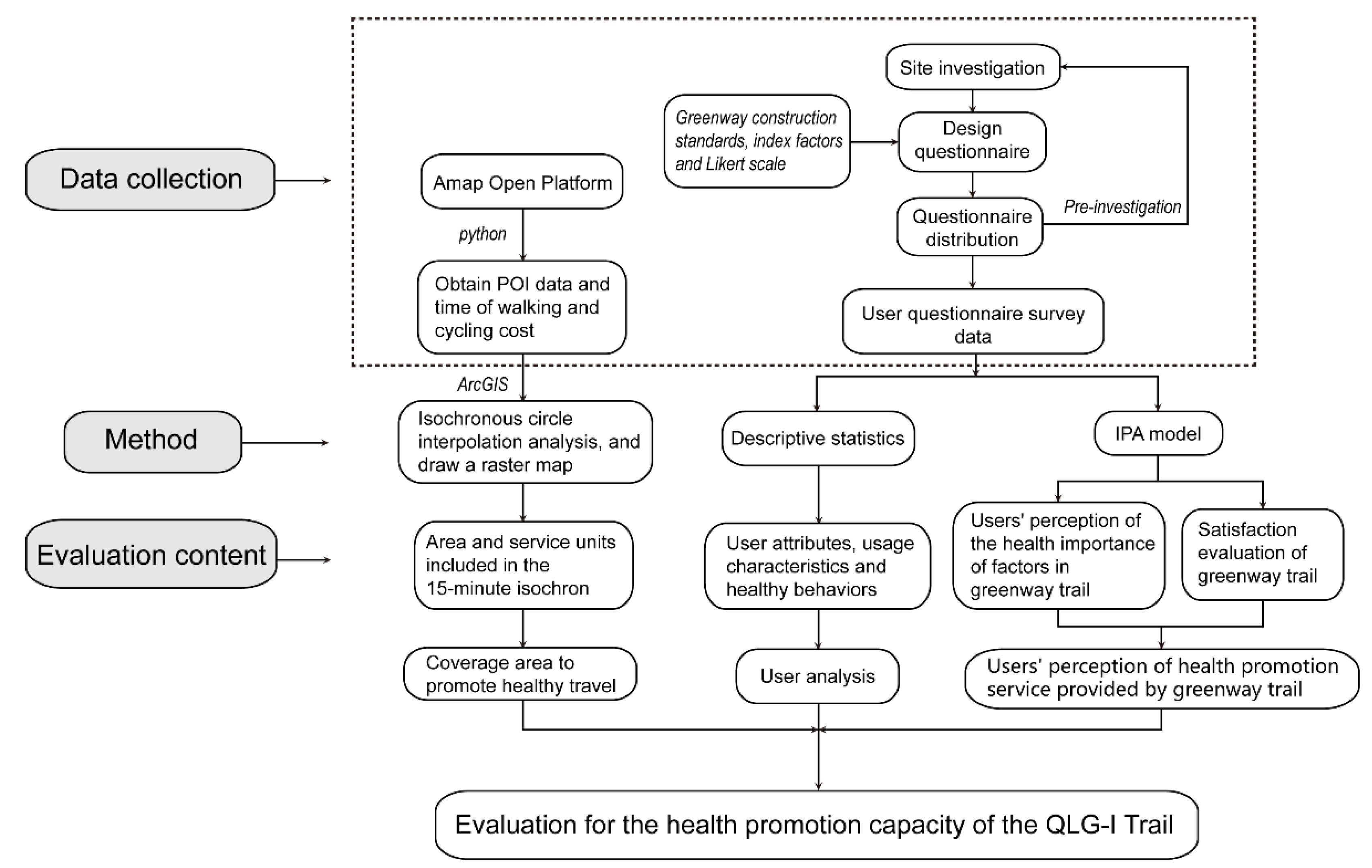
Following the research of Tang et al. [26,42], we constructed the methodological framework of this research based on the functional characteristics of greenways and trails, i.e., green travel, sports activities, and leisure and entertainment, combined with reachability analysis, user characteristic analysis, and the IPA model (Figure 2). This includes service scope analysis, user analysis, and the perceptual evaluation of trail attributes in terms of health promotion. First, we used the Amap open platform (https://lbs.amap.com/ (accessed on 12 April 2021) for the nearby search and path-planning functions, to obtain point of interest (POI) data and time data for walking and cycling, and to combine the improved isochronous circle analysis method for green space traffic accessibility [43] to estimate the scope of greenway trails to promote healthy travel services.
Among these, the sample points were selected to more accurately obtain the time required for nearby residents to walk or ride to the entrance of the trail to perform a more accurate analysis of the scope of healthy travel services compared with the buffer zone. An isochronous circle refers to the range covered by the distance that can be reached within a specific amount of time by selecting different modes of transportation from a certain point [44] and is commonly used in urban infrastructure accessibility analysis, urban traffic analysis, etc. [45,46,47].
The above method combines the tools of the Amap open platform and the isochronous analysis model to reduce the survey time and is more in line with users’ real travel situations. Then, through direct observation, interview records and questionnaires, we can understand the usage habits and health behaviours of different service groups. We administered an IPA scale to obtain user perceptions in terms of health promotion. Based on the collected user feedback data, we can provide users with better services to meet their needs in terms of health promotion.

3. Methods

3.1. Study Area

The research results of this article are based on empirical research on the QLG. In the past three decades, similar to other cities, Hangzhou city, in Zhejiang Province, China, has been experiencing rapid and prosperous urban construction. In this regard, the construction of greenways has been the focus of Hangzhou’s green infrastructure construction. As of 2020, the city had built approximately 3713 km of greenways, and the selection of the most beautiful greenways is held every year. The QLG Trail has a length of 42.195 km and consists of 12 main entrances and 13 service points connecting the surrounding communities and connecting to the public transportation system.
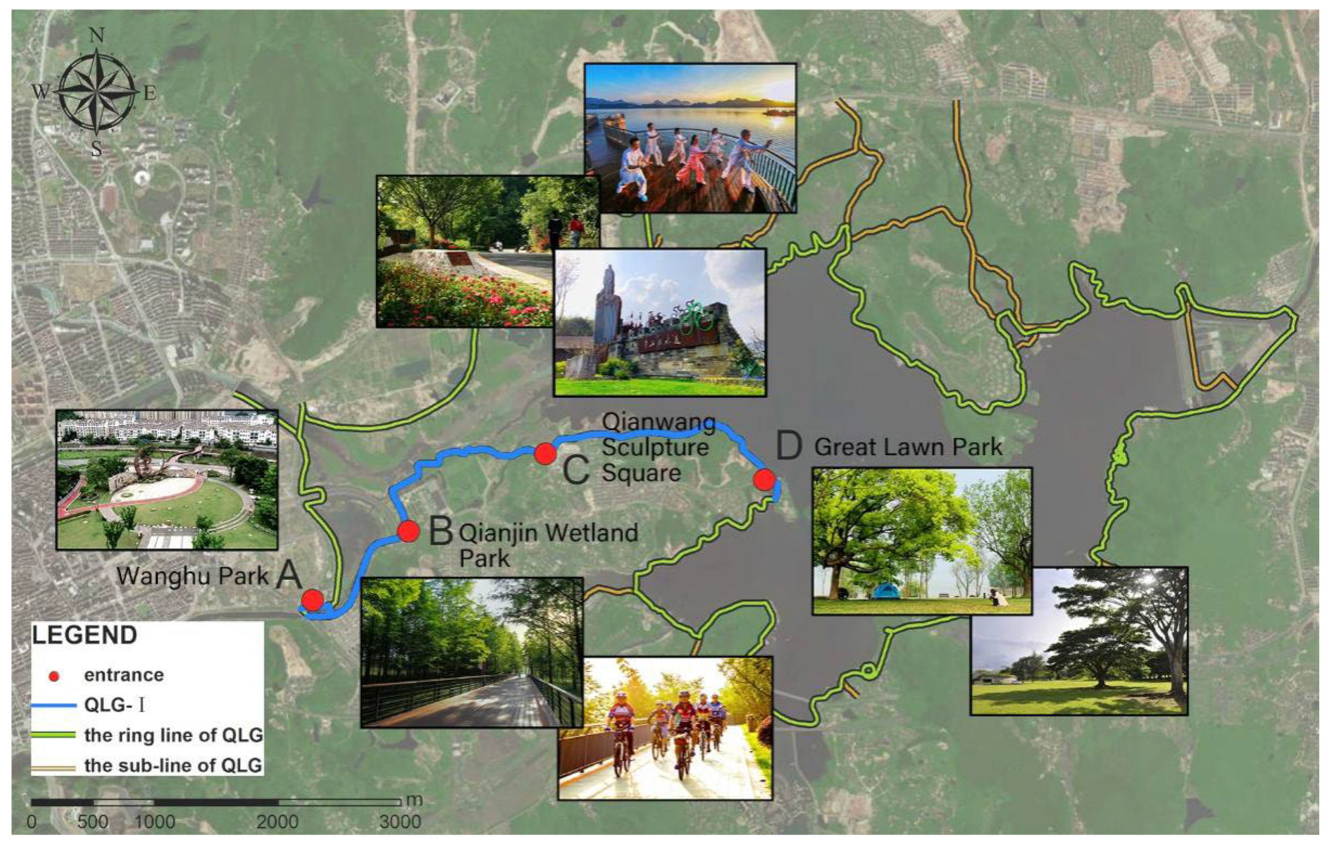
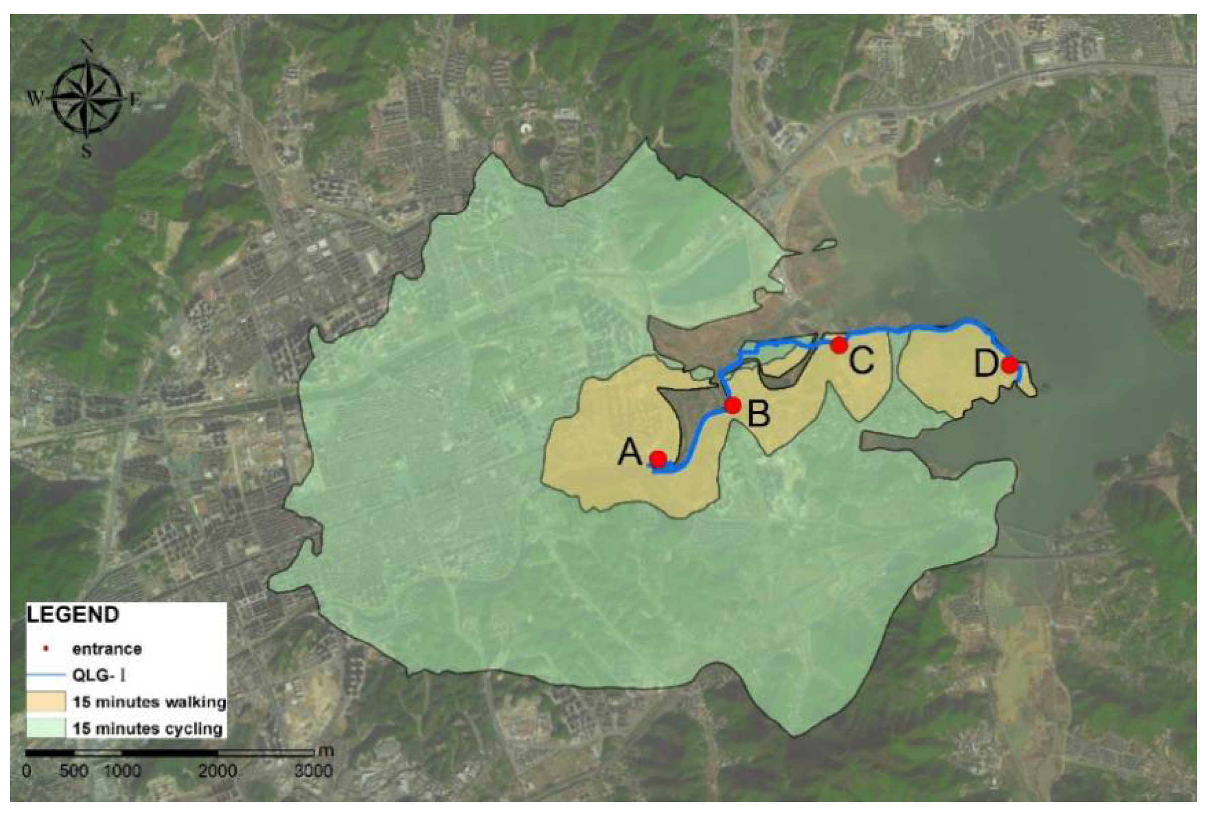
The design concept of the QLG, “returning the lake to the people”, is to provide residents with places to experience nature, walk, jog, and cycle for fitness and to increase residents’ opportunities for outdoor activities to achieve the purpose of health promotion. The greenway was built in three phases. Among them, the Qingshan Lake Greenway Phase One (QLG-I) Trail focuses on culture, ecology, and sports. The standard width is 4 metres, and the total length is approximately 10 km (Figure 3). It was completed and put into use in 2017. In the same year, it was named one of the “Most Beautiful Greenways in Zhejiang”. The QLG-I Trail is the main passage for residents of Lin’an city to enter Qingshan Lake National Forest Park. Compared with the second and third phases, it has a longer use time and a higher utilization rate.
The QLG-I Trail has four entrances and exits, namely, Wanghu Park (point A), Qianjin Wetland Park (point B), Qianwang Sculpture Square (point C), and Great Lawn Park (Point D). It is also an important landscape node along the greenway. These points divide the QLG-I Trail into three sections. The entrance of the AB section of the trail is close to the city’s road transportation hub and is the closest to the city, and there are dense residential areas nearby. This section of the trail is located on the lake, and there are large wetlands and spruce forests nearby. This section of the trail was built on Beacon Hill, with dense vegetation on both sides, and it extends to the central area of the Qingshan Lake Scenic Area. It is the longest of the three sections.

3.2. Data Collection

3.2.1. POI Data and Travel Time Cost Data

POI data and travel time data were obtained from the Amap open platform and captured by Python tools. POI data were obtained through peripheral searches, and travel time data were obtained through path planning. The walking speed set in the path planning was approximately 4.2 km/h, and the cycling speed was approximately 12 km/h.
First, with the geographical coordinates of the QLG-I Trail, four sites (Points A, B, C, and D) were used as the centre of circles with a radius of 10 km to find the entrances surrounding commercial, residential, and transportation facilities; to find the geographical coordinates, addresses, and other POI data; and to remove invalid points under construction. Second, we used the path-planning service and took the geographical coordinates of the POI data obtained in the first step as the sample point (starting point) and the geographical coordinates of the four sites of the QLG-I Trail as the target point (end point). Third, we obtained all the time spent on each path from the sample point to the target point by path planning with walking and cycling and with the time cost attribute of each sample point.

3.2.2. Questionnaire Design and Site Investigation

The survey time was from June to July 2020, and it had been 3 years since the opening of the QLG-I Trail. The survey was divided into two stages. The first stage mainly investigated the use of the trail. During the period from 7:00 a.m. to 9:00 p.m. on 13 June, we observed and recorded users’ behaviour, habits, and activity types without interference.
Then, a questionnaire was designed based on the results of the observation records to evaluate the user attributes, the basic use of greenways, and the IPA evaluation scale for the trail. The IPA evaluation scale was based on The Construction Technical Guidelines of Hangzhou Greenway System (Pilot edition) and QLG planning and design data, and it included five types of evaluation factors—road quality, supporting facilities, the natural environment, regional cultural characteristics [7,34,48,49,50], and management and maintenance—for a total of 25 index factors (Table A1).
The second stage was the distribution and collection of questionnaires. Researchers randomly distributed 20 questionnaires on the QLG-I Trail in the morning and evening of 16–17 June for the pre-survey and asked the interviewees whether the questionnaire content was reasonable. The questionnaire data obtained at this time were used only to modify the questionnaire, not as the main data of analysis in the research. Then, we chose 5 days (sunny weekends or working days) from June to July to formally distribute the questionnaire on site and ensured that the time and place were the same as those of the pre-survey. A total of 243 copies were distributed, of which 201 valid questionnaires were obtained, for an effective response rate of approximately 82.7%.

3.3. Data Analysis

Kriging is a regression algorithm for the spatial modelling and prediction (or interpolation) of random processes or random fields based on the covariance function [51]. In a specific random process, the kriging method can give the best linear unbiased prediction (BLUP); thus, it is often used to estimate the phenomenon of point data distribution on a surface [52].
In this study, the obtained sample points with time cost attributes and target point data were used to create a buffer with a radius of 10 km for the target point as the estimated reach of 15 min of cycling. Then, we used kriging interpolation to convert the time cost attribute value of the sample point into the raster attribute value of the target point and drew the raster map of walking and cycling in different time periods of four target points in the circular buffer, which was used to analyse the service situation of the QLG-I Trail for promoting healthy travel.
After the survey, questionnaire data obtained in paper form were statistical analysed. Descriptive statistics were used to analyse the demographic characteristics and basic use of the trail. Based on the IPA evaluation scale data on the QLG-I Trail, we conducted an overall reliability test of the 201 questionnaires through the internal consistency coefficient (Cronbach’s alpha coefficient [53] or the α value). The α value of those questionnaires was 0.922, i.e., greater than 0.7, indicating that the questionnaire reliability test score was high. The questionnaire design was reasonable and had good reliability.

4. Results

4.1. The Scope for Promoting Healthy Travel of the QLG-I Trail

4.1.1. The Walking and Cycling Accessibility of the QLG-I Trail

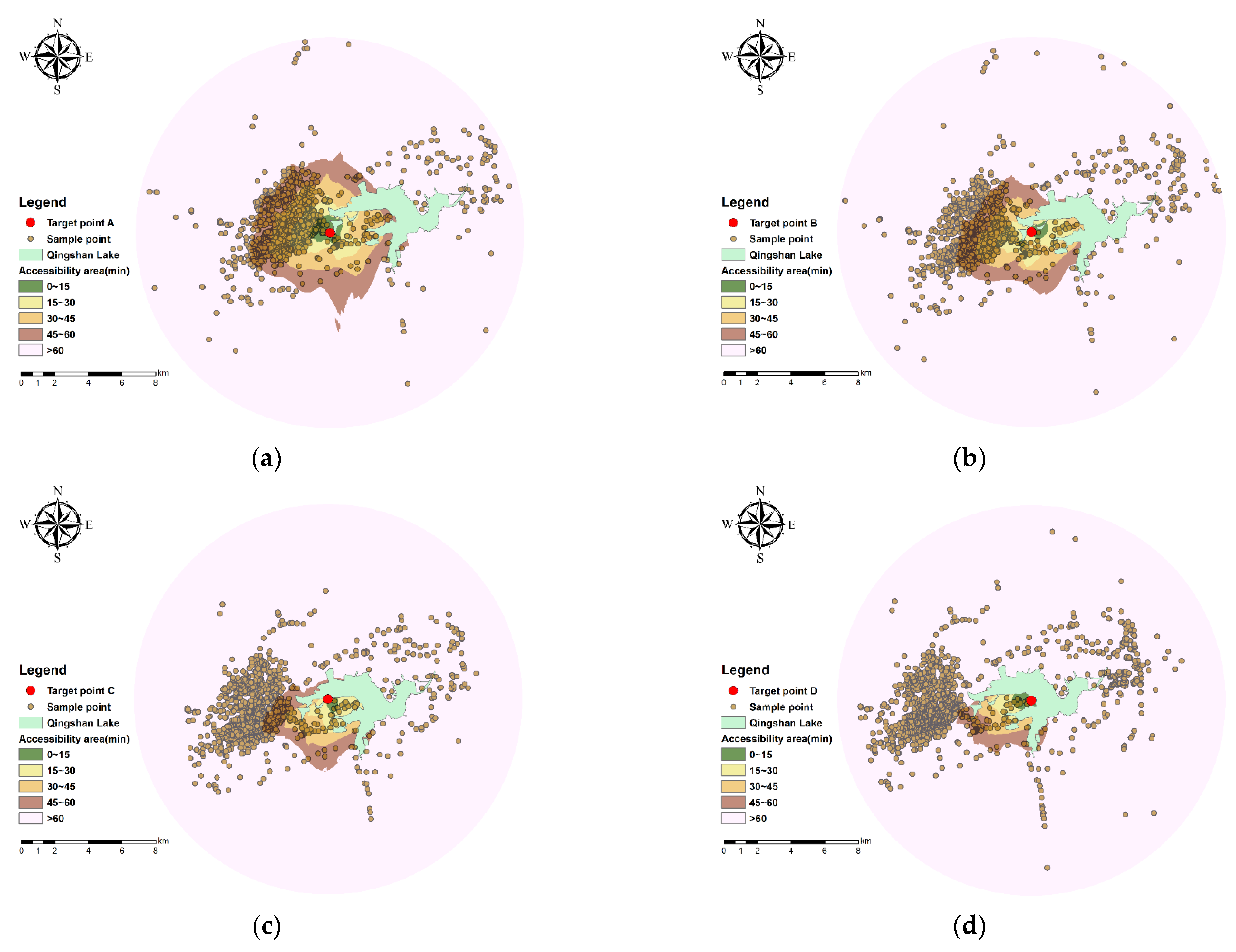
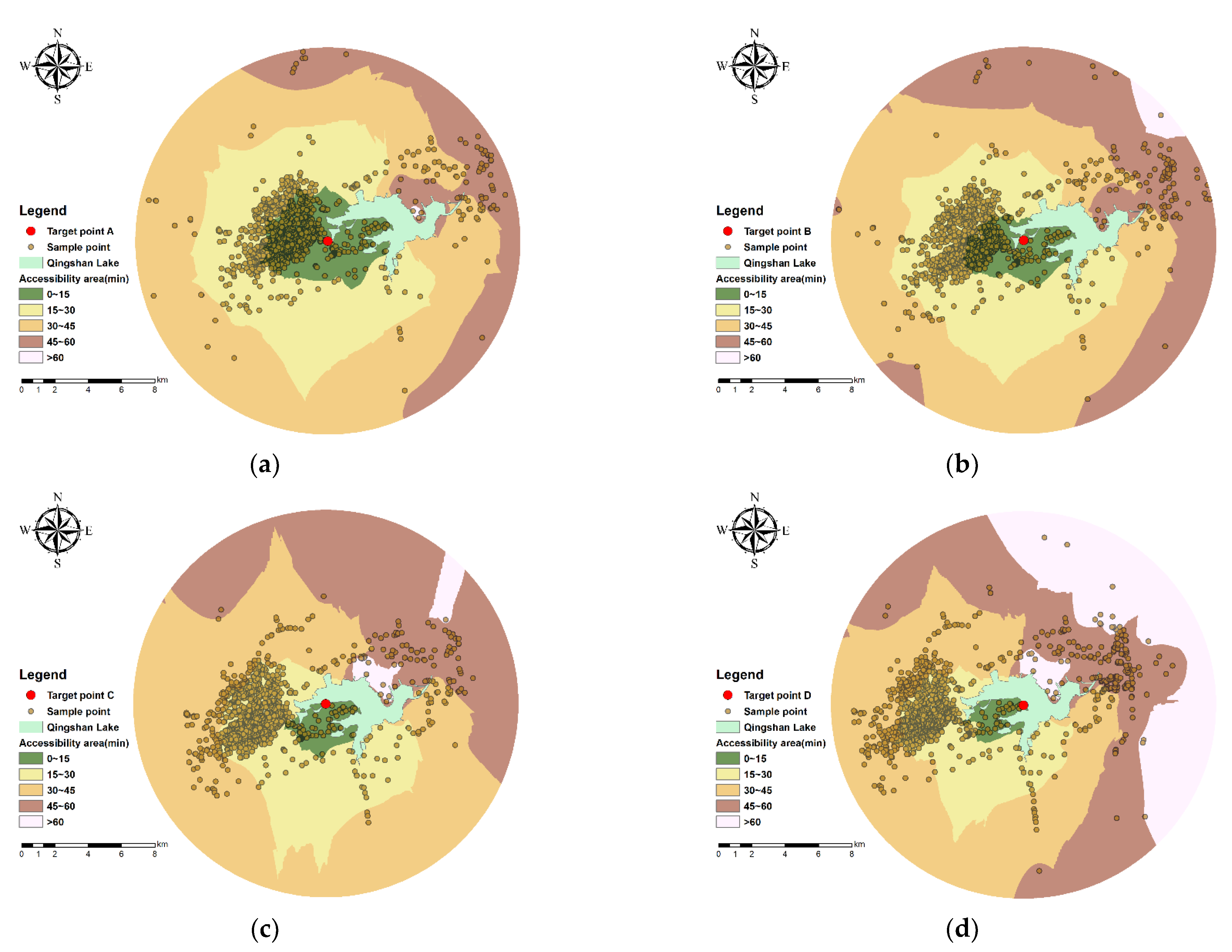
To analyse the difference in the accessibility of different target points, we drew isochronous grid maps of walking and cycling at four target points (Figure 4 and Figure 5), dividing the time cost data on the four target points into five time periods: 0–15, 15–30, 30–45, 45–60, and greater than 60 min. Both Figure 4 and Figure 5 reflect the distribution of the actual time spent travelling from the four target points to each sample point. The isochronous shape of each target point is not theoretically circular, and the spacing is unevenly distributed. Based on the distribution of the sample points and the curvature of the isochrones, the distribution of the surrounding terrain and road network can also be inferred.
Figure 4 shows that the area of the circle from point A to point D within 1 h of walking gradually decreases, while the accessibility gradually weakens. Clearly, the area reachable within 15 min of walking accounts for a relatively small proportion of the circular buffer zone. Figure 5 shows that the area of the circle from point A to point D within 1 h of cycling gradually decreases. The reachable range within 1 h of cycling at the three points A, B, and C basically covers the circular buffer zone. The area that can be reached by cycling within half an hour is also wider. Taken together, the results show that the accessible range of cycling within 1 h is significantly greater than that of walking. The circle for 45 min of walking is similar in shape and size to that for 15 min of cycling, indicating that the accessibility of walking for 45 min and that of cycling for 15 min are relatively close.

4.1.2. The Promoting Healthy Travel Range of the QLG-I Trail

This study first extracted the isochrones from the sample points to the four target points and calculated the isochronous area of the walking and biking travel time within 15 min (excluding water areas, such as Qingshan Lake) as the actual service scope (S) of the four target points for promoting healthy travel. Second, we separately counted the total number of sample points of the four target points within the 15 min circle as the number of health-promotion-service units (n).
Finally, the sample points in the buffer of the four target points were gathered, and 2116 valid sample points (Table 1) were obtained after removing duplicate points. At the same time, we superimposed the reachable range of walking and cycling for each target point as the scope for promoting health travel of the QLG-I Trail (Figure 6) and calculated the total service area and the total number of sample points.
Compared with other target points, point A has the best accessibility and widest coverage of promoting healthy travel service, whether by walking or cycling (Table 1). In terms of walking, the accessibility of point C is the worst, and the scope of the promoting healthy travel service is small. However, the results for cycling show that point D is the worst. The largest difference in service area between the two modes of travel is at point B, where walking accessibility is lower, while cycling accessibility is higher.
According to the results, the walking area of the QLG-I Trail within 15 min is approximately 4.35 km2, and the cycling area is approximately 29.45 km2. In general, the accessibility of the four entrances of the QLG-I Trail within 15 min is as follows: A > B > C > D. The walking area of the QLG-I Trail within 15 min is mainly the nearby residential areas and traffic stations along the line. The cycling area is mainly concentrated in some central urban areas and towns on the west side of Qingshan Lake.

4.2. The User Analysis of the QLG-I Trail

4.2.1. User Attributes and Use Characteristics

Table 2 shows that, in terms of the proportion of respondents, there were slightly more women (51.2%) than men (48.8%); however, the difference was small. In terms of age groups, there were people of all ages. The respondents were mainly young and middle-aged people aged 18–55 (85.6%), and 13.4% of the respondents were over 55 years old. Users were primarily local residents from residential areas around the greenway and downtown (88.6%). There were a smaller number of people from areas outside of Hangzhou city (4%).
Regarding the frequency of use, 37.8% of respondents used the trail multiple times a week, and 24.9% used it daily. The respondents’ main mode of transportation was walking (50.2%), followed by cycling (27.9%) and driving (17.4%). Due to the imperfect public transportation facilities near the QLG-I Trail, fewer people used public transportation (4.5%). Daily visits were mostly concentrated in the hours of 7:00 a.m.–9:00 a.m. and 5:00 p.m.–8 p.m., accounting for 33.3% and 46.3%, respectively.

4.2.2. Health Awareness and Health-Promoting Behaviour of Users

The QLG-I Trail users’ health status survey was based on the respondents’ opinion of whether maintaining their health status required physical exercise, which was divided into five levels: exercise being very necessary, necessary, comparatively necessary, normal, and no need (with cognitive intensity decreasing in order). The results show (Table 3) that 33.83% of the respondents think that they urgently need more physical exercise, half of the respondents (47.76%) think that they need physical exercise, and only a small number of people (1.49%) think that they do not need it. Most of the interviewees had relatively high self-health awareness, which also reflects their pursuit of a healthier lifestyle.
Through on-site observation and the distribution of questionnaires, this paper counted the types and frequency of the health-promoting behaviours of the respondents (Table 4). Behaviours, such as physical exercise, social interaction, entertainment and leisure, and natural experience, which promote people’s physical or mental health, are termed health-promoting behaviours. Overall, physical exercise (40.8%) and natural experience (28.1%) occurred frequently, while social interaction (8.1%) and entertainment and leisure (15.3%) activities occurred less frequently.
According to the analysis of health-promoting behaviours (Table 5), within the 95% confidence interval, there were significant differences in health-promoting behaviours among users in different places of residence. People who lived within a close distance tended to exercise, while those who lived far away tended to choose a natural experience. However, the p values of different genders and age groups were all greater than 0.05, indicating that there was no significant difference in the probability of the occurrence of health-promoting behaviours between them.

4.3. The Perceptual Evaluation of the Trail Attributes in Terms of Health Promotion

4.3.1. IPA of Factors That Affect Health Promotion

The 25 index factors had an average score of 3.19 to 4.64 (Table 6), indicating that the respondents had a high perception of the importance of these functions (between “average” and “very important”). Moreover, their standard deviations were all less than 1.2, indicating that the respondents had relatively small deviations in their perceptions of and attitudes towards the importance of these functions.
The top five index factors with average scores were S4, S21, S25, S2, and S5. The highest average score for the evaluation factors was for management and maintenance (4.47), while the second highest was for road quality (4.43). These scores are similar; thus, the interviewees believed that the factors that affect the health-promoting behaviour of QLG-I Trail users are mainly concentrated in them. In addition, the natural environment of the QLG-I Trail obtained a high score (4.37). In comparison, the S17, S18, and S19 index factors of the regional cultural characteristics were considered to be the least important influencing factors because their comprehensive average score was low (3.63).

4.3.2. Satisfaction Evaluation of the QLG-I Trail

The average satisfaction score of the 25 index factors was between 2.99 and 4.39 (Table 6). Compared with the importance perception of factors that affect health promotion, the overall score for satisfaction evaluation was lower, indicating that most interviewees believed that the actual performance of the QLG-I Trail did not meet their expectations.
The index factors of the natural environment had an average score of 4.2 points or more, and their standard deviations were relatively low, indicating that users were satisfied with the natural environment around Qingshan Lake. Conversely, the three lowest-ranking index factors were S7, S9, and S10. The high occupation of parking lots, inconvenient bicycle rental facilities, and few toilets and benches offered users a poor recreational experience, resulting in the lowest satisfaction evaluation score for the supporting facilities indicators (3.46).

4.3.3. IPA Chart

In this study, we drew an IPA scatter diagram (Figure 7) to analyse the impact of the importance and satisfaction with the greenway factor of the QLG-I Trail for users’ health-promoting behaviour.
Quadrant 1 is the Keep Up the Good Work area, and it includes 10 index factors (Figure 7). The average scores are higher than the overall average importance score and average satisfaction score. The evaluation results of this quadrant show that the natural environment, road quality, and management and maintenance of the QLG-I Trail were more prominent overall, and user satisfaction was relatively high. Notably, however, the average value of the index factors for satisfaction in this quadrant was lower than the average value for importance. Therefore, while the QLG-I Trail continues to maintain its advantages, managers should tap its development potential and continuously improve the corresponding functions.
Quadrant 2 is the Possible Overkill area, and it includes six index factors. As shown in Figure 7, their average scores were lower than the overall average importance score but higher than the overall average satisfaction score. The evaluation results of this quadrant showed that users generally have a high degree of recognition of these index factors; however, the impact on users’ health-promoting behaviours is not considered very important, especially the regional cultural characteristics of the QLG-I Trail. In the opinion of the interviewees, these characteristics focus on showing the cultural features of the Lin’an District, which increases residents’ spiritual identity; however, the promotion of healthy behaviour is not apparent.
Quadrant 3 is the Low Priority area, and it includes three index factors. Additionally, these average scores were lower than the overall average importance score and average satisfaction score. The results of this quadrant show that parking lots, commercial service facilities, and public health were not important indicators for promoting the health service capacity of the QLG-I Trail and can be appropriately controlled. However, this does not mean that the functions of these index factors are not taken seriously. Their average importance scores were above 3.5, and there is still much room for improvement. Moreover, the satisfaction with the index factors in this quadrant was low. If they are ignored, they may lead to poor overall performance.
Quadrant 4 is the Concentrate Here area, and it includes six index factors. These average scores were all higher than the overall average importance score and lower than the overall average satisfaction score. The evaluation results of this quadrant show that users believed that the safety protection facilities, humanized equipment, and cleanliness of the environment of the QLG-I Trail were more important for their health-promoting behaviour; however, they were not very satisfied with the current service quality. Therefore, managers should pay attention to the service quality of the indicator factors in this quadrant and provide a more comfortable and safer greenway environment to promote healthy behaviour.

5. Discussion and Conclusions

5.1. Research Contribution

This research focuses on the health-promotion-service capabilities of greenways. It evaluates the health promotion services provided by the QLG-I Trail based on accessibility and user perceptions and evaluations. It makes three unique contributions to the research on country greenways. As the first contribution, this study assessed the scope of the health promotion services of greenway trails based on the accessibility of walking and cycling.
The path-planning function provided by open digital map platforms improves the ambiguity of the scope obtained by using buffer zone analysis in previous studies [54,55], which is helpful in determining the service scope of greenways and even other green infrastructures. As the second contribution, this research studied the health promotion services of country greenways from the perspective of user perceptions. Previous studies on country greenways have focused more on ecological services or social benefits [56,57,58], ignoring the role of greenways in promoting health. Finally, by investigating user perceptions of the attributes of the QLG-I Trail, this study contributes by exploring which factors affect the occurrence of health-promoting behaviours in a country greenway.

5.2. Promotion of Healthy Travel

The research results show that there were clear differences in the accessibility of the main entrances and exits of the QLG-I Trail. This discovery was also made in Coutts’ research. By segmenting multiple greenways and calculating the population density, land-use mix, and number of greenway users in the area, he concluded that the accessibility of each part of the greenway was different and was affected by a variety of factors [4]. This difference is related to the linear characteristics of the greenway, which is fundamentally different from a large area of parkland [59,60].
This difference can easily cause users to concentrate on a certain section, while other sections are less used, which further leads to the idleness or waste of greenway resources in certain sections, regardless of whether they are natural resources or infrastructure resources. Another study by Coutts also showed that the green road sections that intersect the park and the green road sections where commercial land is concentrated had the largest usage, and the accessibility differences were more obvious [61]. Therefore, a greenway should not be regarded as a whole in terms of reachability analysis; instead, the reasons for the differences in each section should be analysed to take targeted optimization measures.
In this case study, point A is close to the main urban area and is connected to the main regional transportation routes with the best walking and cycling accessibility. Points C and D are far from the main transportation routes, and the surrounding terrain is steep. There are several large residential communities distributed in the area, and the population density is not low; however, the community is closed and cannot be traversed. The transportation cost of reaching the greenway is relatively high; thus, the accessibility is poor. In general, residents go to greenways located in urban areas mainly by walking, while it takes a long time to go to country greenways, which can be easily reached by means of bicycles or motor vehicles [62].
Therefore, based on this difference, greenway builders should allocate infrastructure differently to avoid resource shortages or waste. Furthermore, greenway builders should consider how entrances and exits with poor accessibility should be better integrated into the regional transportation system to guide the average distribution of users on the greenway. In addition, in this case, we noticed that Qingshan Lake, as a country greenway connecting urban and rural areas, has poorly accessible entrances and exits. It is mainly distributed in rural areas far from the urban end, which also reveals that the degree of convenience of transportation systems in urban and rural areas is different.
A review study by James showed that the accessibility of green spaces is frequently related to socio-economic status. Groups with lower socio-economic status obtain less green space but may benefit more from the use of green spaces. Therefore, the rational allocation of green space elements and the enhancement of the accessibility and fairness of marginal green spaces can further alleviate the differences in socio-economic health [63]. Our strategy is based on this view.
In addition, the reachability analysis showed that QLG-I Trail’s pedestrian and bicycle areas within 15 min cover only the surrounding communities and towns, and the trail’s service scope is limited. The user survey results also showed that the audience of the trail is mainly residents of nearby communities, and approximately 78% of users visit on foot or by bike. This result is relatively consistent with the preference research results of Dorwart et al. and Keith et al. on the use of greenway trails, with trail visitors being mainly nearby residents [62,64].
Therefore, greenway managers can consider constructing a network of non-motorized transportation systems that extend to every residential community and improve the connectivity and matching between the country greenway space and the urban non-motorized commuter space to adapt to and encourage users to travel in these healthy ways [65,66]. At the same time, greenway managers should consider benefiting a wider range of people. Combining visiting methods and the fact that fewer people use public transportation, sufficient parking lots for bicycles and motor vehicles can be built near the main entrances and exits, and the connection between the main entrances and exits of a greenway and public transportation can be strengthened to provide more convenient travel services for users who are far away [21,49].

5.3. Health-Promoting Behaviour

In the user questionnaire survey, 91% of visiting users clearly stated that they need to exercise, which shows that the health awareness and fitness willingness of visiting users are very strong, and the results of the health-promoting behaviour survey also showed that physical exercise was their main activity in Qingshan Lake.
Therefore, the ability of the QLG to provide health-promoting behaviour services should be the top priority for builders and managers to consider, especially the construction of facilities for physical exercise. The survey results of the questionnaire regarding the users’ place of residence showed that users who live closer to the trail liked physical exercise, while users who lived farther away were more inclined towards natural experience activities, indicating that the purpose of visiting and distance are related. This result is an unexpected discovery. Previously, results relating the purpose and distance of the visit had not been seen in the greenway-related literature [67,68,69], and the specific reasons warrant in-depth follow-up research.
Taking into account the preferences of users at different distances, greenway planners can set up locker rooms, bag storage places, and other supporting facilities in sections close to surrounding residential areas, set up open spaces, such as paved squares or provide better pavement for physical exercise, which is also conducive to better group fitness activities, such as the group square dancing that middle-aged and elderly women in China love to do [70]. In sections away from surrounding residential areas, high-quality scenic sections can be set up for people to experience nature, such as meditation seats and nature science signs [71].
In addition, the survey results on users’ visiting time showed that the trail had a large traffic flow between 5:00 p.m. and 8:00 p.m., which is consistent with Xiong et al.’s research results [42], proving that the summer evening is the peak period for greenway trail users. Many surveys and studies have shown that safety (in various forms) should be the top priority of greenway managers and planners [34], and a considerable amount of research has also focused on safety issues in green space management [72].
Therefore, taking into account the users’ demand for greenway trail health promotion services at night, greenway managers can adopt smart city design methods to integrate landscape lighting systems, environmental music systems, security systems, and security patrol systems to supplement a complete sports identification system and multimedia publishing system, which can play a role in spatial guidance, preventing sports injuries, and even reducing criminal acts [34].

5.4. Trail Attributes Affecting the Health Promotion of Country Greenways

With regard to the factors that affect the intervention of greenways to promote healthy behaviours, according to the IPA scale survey results, the natural environment is a factor that users consider to be of high importance and with which they are highly satisfied, indicating that the complete and continuous natural environment in linear spaces is an important factor for attracting users to outdoor sports and releasing psychological stress. Research has also shown that continuous green space has a positive effect on reducing stress and improving health [73].
Therefore, we should continue to maintain the original rich natural environmental resources of greenway trails. Furthermore, we should pay attention to avoiding damage to the linear landscape caused by certain infrastructure. In particular, we should pay attention to the cutting of the continuity of greenways by transportation facilities. Three-dimensional overhead can be used to eliminate the damage caused by park entrances and exits and road intersections to the linear spatial continuity of greenways and to construct a closed loop of scenery without breakpoints throughout the process. Ahn et al. also confirmed the important role of such measures in reducing air pollution [74].
In addition, surveys of user visits have shown that factors, such as protective barriers, cleanliness, fire safety, trail comfort and barrier-free access are important factors that trail users believe promote healthy behaviour, while historical allusions, traditional construction techniques and the application of local materials have not had much impact on promoting healthy behaviour. At the same time, the survey results also showed that users are not very satisfied with the QLG-I Trail’s parking lot, lighting system, and cleanliness. In particular, the six indicators (protective fences, wheel chair accessibility, the lighting system, cleanliness, security guards on patrol, and fire safety) in quadrant 4, the Concentrate Here area, mainly involve two aspects: safety protection and infrastructure for caring for vulnerable groups.
An IPA evaluation of the Atlanta Loop Greenway in Georgia, USA also found that residents were dissatisfied with various forms of safety elements on greenways [34], and the evaluation of the use patterns of and design preferences for sports activities for elderly people on the Berlin Creek Greenway also reflected care for vulnerable groups [64]. Therefore, in addition to adopting the complete service facilities mentioned earlier, attention should be paid to night lighting and to ensuring the continuity of routes.
Greenway managers should also pay attention to the special needs of vulnerable groups and humanized construction details to improve the safety, fairness, and comfort of greenway use (for example, ensuring that the flatness and elasticity index of road surface materials meet the needs of the physical characteristics of children and elderly people) [75]. For the vegetation on both sides of a trail, tree species that do not cause respiratory diseases should be chosen. In addition, facilities for disabled people who can perform physical activities alone can be added [76], and it is important to ensure their safe use.

5.5. Public Participation

In this study, through the reachability analysis of the QLG-I Trail and user surveys and interviews, greenway users’ preferences and health-promoting behaviours were investigated. The results of the study reflect that some of the greenways of the QLG-I Trail lack continuity, management and maintenance are not in place, and there are additional issues. This bottom-up survey and research method can obtain real feedback from greenway users on a greenway, and the research results and discussion can help greenway managers optimize greenways in a targeted manner. The research by Lee et al. showed that public participation can strengthen people’s sense of responsibility to the local area and make it easier to meet users’ psychological expectations and gain users’ recognition [50].
Therefore, the mechanism of public participation is very effective and deserves to be applied and promoted in the subsequent greenway operation and renewal process. In research related to greenway planning and management, a considerable amount of research explores how to effectively apply this mechanism. By investigating the post-use evaluation of greenway users, Chi et al. analysed whether the top-down strategy matched the daily lives of residents [77]. Lim et al. encouraged public participation by organizing activities and publishing development strategies [78].
For example, through “voluntary art activities” in regenerating cultural and artistic spaces, the public is called on to participate at the individual, community and urban levels to promote the sustainability of urban communities. A dynamic abiotic, biological, and cultural (DABC) system framework was proposed to prioritize policy attributes through public participation and adaptation to changes in the planning environment and scenarios [79]. There is also the “AngelGREEN” Green Network Development Strategy for the 13th District of Budapest, which is not only a framework for prioritizing the company’s management responsibilities but also intended to help to gradually increase public participation in green network planning and maintenance [80].
Drawing on the research results above, we believe that greenway managers can set up a project management committee composed of user representatives, government management departments, fitness and sports volunteer organizations, sports brand merchants and professional operation teams. In this way, government management departments can better respond to the needs of users, and participants from all parties can also participate in the organization, publicity, and supervision of activities to make the health-promotion-service provision of greenway trails more extensive and efficient.

5.6. Research Limitations and Future Directions

The shortcomings of this research and the future directions are the same as those of previous studies. This research still needs to be improved in the following ways. First, this paper took country greenways as an example. There is no comparative study on the health promotion capabilities of urban greenways and trails, which has certain limitations. Second, young people account for only a small proportion of the respondents; however, in reality, such people often travel with their families and are also important service objects of greenways [81,82]. Therefore, research should strengthen the promotion of healthy behaviours among young people.
Third, the main factors considered in this study that affect the promotion of healthy behaviours are not yet comprehensive. Social factors, such as users’ living habits, working environment, and educational level, as well as climatic factors, such as seasonal changes, may also have an impact. In subsequent research, the visual–aesthetical characteristics provided by the greenway should also be valued in terms of health promotion, such as the impact of dynamic changes in viewing angles or viewpoints on users’ psychological feelings.
Finally, we will gradually make up for the shortcomings of the above research and continue to conduct and improve the post-use survey and evaluation research of the entire QLG in terms of greenway intervention and health promotion, with the aim to provide further practical value for landscape planning and the design of similar greenways.

Author Contributions

Conceptualization, B.X. and Q.S.; data curation, B.X. and Q.S.; formal analysis, Q.S. and Y.Z.; funding acquisition, B.X.; investigation, Q.S.; methodology, Y.Z.; software, Q.S.; validation, B.X. and Q.S.; visualization, Q.S.; writing—original draft, B.X. and Q.S.; writing—review & editing, Y.Z. All authors have read and agreed to the published version of the manuscript.

Funding

This research was funded by the Key Research and Development Program of the Zhejiang Provincial Department of Science and Technology, grant number 2019C02023.

Institutional Review Board Statement

Not applicable.

Informed Consent Statement

Not applicable.

Data Availability Statement

Not applicable.

Acknowledgments

This research was financially supported by the Key Research and Development Program of the Zhejiang Provincial Department of Science and Technology, grant number 2019C02023. The authors would like to thank the anonymous reviewers for their helpful and constructive comments.

Conflicts of Interest

The authors declare no conflict of interest.

Appendix A

Table A1. Health service quality evaluation index of the QLG-I Trail.
Evaluation FactorsIndex Factors 1Explanation
Road QualityS1 WidthStandard width 4 m
S2 Comfort of pavement for peopleSuitable for walking, jogging or biking
S3 Connectivity with other branchesGreenway entrances or exits are easy to reach
S4 Protective fenceWaterfront guardrail, mountain rock enclosure
S5 Wheelchair accessibleWalking or cycling barrier-free, serving special groups
Supporting facilitiesS6 Signage systemInformation signs, guidance signs and warning signs
S7 Parking lotBicycle or car parking lot
S8 Lighting systemCombination of different lamps
S9 Commercial service facilitiesRetail stores, bicycle rental, greenway relays
S10 Public healthToilets, dustbins, hand sinks
Natural environmentS11 Terrain diversityWetlands, hills, fields, lakes and mountains
S12 Colourful plant landscapeMetasequoia forest, wet plants, farmland, flower bushes
S13 Scenery lineRidgeline, wood line, lakeshore line
S14 Meteorological landscapeLandscapes that change over time or seasons like sunrise, rain, or dusk
S15 Biological landscapeBirds, fish, squirrels and so on
Regional cultural characteristicsS16 Greenway theme reflectsGreen ecology, health or sports
S17 Historical allusionsWuyue culture
S18 Traditional construction techniquesSeal cutting, carving, masonry technology
S19 Application of local materialsBricks, stones, tiles and Bamboo
S20 Sense of belongingWilling to be close, stay and enjoy
Management and maintenanceS21 CleanlinessNormal environmental cleanliness
S22 Security guards patrolSecurity personnel, guardhouses, alarms
S23 The facilities are fully equippedAll facilities can be used normally
S24 Plant conservationWhether the plant has pests and diseases and its growth status
S25 Fire safetyFire-fighting facilities, emergency escape routes
1 All index factors are measured using the Likert 5-point scale (“very satisfied”, “satisfied”, “average”, “unsatisfied”, and “very unsatisfied” five answers, which are recorded as 5, 4, 3, 2, and 1).

References

  1. World Health Organization. Health Promotion Glossary of Terms 2021; World Health Organization: Geneva, Switzerland, 2021. [Google Scholar]
  2. Lortet, P. The greenway concept: Lane for non-motorized traffic, leisure area and tool of heritage development. Espaces 1998, 150, 17–24. [Google Scholar]
  3. Lindsey, G. Use of urban greenways: Insights from Indianapolis. Landsc. Urban Plan. 1999, 45, 145–157. [Google Scholar] [CrossRef]
  4. Coutts, C. Greenway accessibility and physical-activity behavior. Environ. Plan. B Plan. Des. 2008, 35, 552–563. [Google Scholar] [CrossRef] [Green Version]
  5. Chen, Y.; Gu, W.; Liu, T.; Yuan, L.; Zeng, M. Increasing the use of urban greenways in developing countries: A case study on Wutong Greenway in Shenzhen, China. Int. J. Environ. Res. Public Health 2017, 14, 554. [Google Scholar] [CrossRef] [Green Version]
  6. Lindsey, G.; Wilson, J.; Anne Yang, J.; Alexa, C. Urban greenways, trail characteristics and trail use: Implications for design. J. Urban Des. 2008, 13, 53–79. [Google Scholar] [CrossRef]
  7. Price, A.E.; Reed, J.A.; Muthukrishnan, S. Trail user demographics, physical activity behaviors, and perceptions of a newly constructed greenway trail. J. Community Health 2012, 37, 949–956. [Google Scholar] [CrossRef]
  8. Mundet, L.; Coenders, G. Greenways: A sustainable leisure experience concept for both communities and tourists. J. Sustain. Tour. 2010, 18, 657–674. [Google Scholar] [CrossRef]
  9. Lovely, S.A. The Greenway Trail in Community Development: An Examination of Value, Representation, and Distribution of Benefits among Stakeholders; Virginia Polytechnic Institute and State University: Blacksburg, VA, USA, 2020. [Google Scholar]
  10. Fábos, J.D. Greenway planning in the United States: Its origins and recent case studies. Landsc. Urban Plan. 2004, 68, 321–342. [Google Scholar] [CrossRef]
  11. Burkhard, B.; Kroll, F.; Nedkov, S.; Müller, F. Mapping ecosystem service supply, demand and budgets. Ecol. Indic. 2012, 21, 17–29. [Google Scholar] [CrossRef]
  12. Geijzendorffer, I.R.; Martín-López, B.; Roche, P.K. Improving the identification of mismatches in ecosystem services assessments. Ecol. Indic. 2015, 52, 320–331. [Google Scholar] [CrossRef]
  13. Mouchet, M.A.; Lamarque, P.; Martín-López, B.; Crouzat, E.; Gos, P.; Byczek, C.; Lavorel, S. An interdisciplinary methodological guide for quantifying associations between ecosystem services. Glob. Environ. Chang. 2014, 28, 298–308. [Google Scholar] [CrossRef]
  14. Fields, B.; Thomas, J.; Wagner, J.A. Living with water in the Era of climate change: Lessons from the Lafitte Greenway in Post-Katrina New Orleans. J. Plan. Educ. Res. 2017, 37, 309–321. [Google Scholar] [CrossRef]
  15. Yang, S. Urban greenway system design under “Integration” strategy: A case study in Shunyi District, Beijing. Urban Transp. China 2012, 10, 7. [Google Scholar] [CrossRef]
  16. Zhao, F.; Nie, R.; Zhang, J.E. Greenway implementation influence on Agricultural Heritage Sites (AHS): The case of Liantang Village of Zengcheng District, Guangzhou City, China. Sustainability 2018, 10, 434. [Google Scholar] [CrossRef] [Green Version]
  17. Baker, T. Ecology of greenways. Landsc. J. 1994, 13, 175. [Google Scholar] [CrossRef]
  18. Kiel, B.E. Greenways in America: The Ecosystem Services of Urban Greenways and Their Neighborhood Benefits; Fordham University: Bronx, NY, USA, 2017. [Google Scholar]
  19. Larson, L.R.; Keith, S.J.; Fernandez, M.; Hallo, J.C.; Shafer, C.S.; Jennings, V. Ecosystem services and urban greenways: What’s the public’s perspective? Ecosyst. Serv. 2016, 22, 111–116. [Google Scholar] [CrossRef]
  20. Yahner, T.G.; Korostoff, N.; Johnson, T.P.; Battaglia, A.M.; Jones, D.R. Cultural landscapes and landscape ecology in contemporary greenway planning, design and management: A case study. Landsc. Urban Plan. 1995, 33, 295–316. [Google Scholar] [CrossRef]
  21. Xie, B.; Lu, Y.; Zheng, Y. Casual evaluation of the effects of a large-scale greenway intervention on physical and mental health: A natural experimental study in China. Urban For. Urban Green. 2022, 67, 127419. [Google Scholar] [CrossRef]
  22. Zhang, W.; Yang, J.; Ma, L.; Huang, C. Factors affecting the use of urban green spaces for physical activities: Views of young urban residents in Beijing. Urban For. Urban Green. 2015, 14, 851–857. [Google Scholar] [CrossRef]
  23. Thompson, C.W.; Roe, J.; Aspinall, P.; Mitchell, R.; Clow, A.; Miller, D. More green space is linked to less stress in deprived communities: Evidence from salivary cortisol patterns. Landsc. Urban Plan. 2012, 105, 221–229. [Google Scholar] [CrossRef] [Green Version]
  24. Thompson, C.W.; Peter, A.; Jenny, R.; Lynette, R.; David, M. Mitigating stress and supporting health in deprived urban communities: The importance of green space and the social environment. Int. J. Environ. Res. Public Health 2016, 13, 440. [Google Scholar] [CrossRef] [PubMed]
  25. Dallat, M.A.T.; Soerjomataram, I.; Hunter, R.F.; Tully, M.A.; Cairns, K.J.; Kee, F. Urban greenways have the potential to increase physical activity levels cost-effectively. Eur. J. Public Health 2013, 24, 190–195. [Google Scholar] [CrossRef] [PubMed] [Green Version]
  26. Tang, H.; Hong, Q.; Xu, B. Landscape performance assessment of phase I of greenway around Qingshan Lake National Forest Park, Zhejiang Province. J. Zhejiang AF Univ. 2020, 37, 1177–1185. [Google Scholar] [CrossRef]
  27. Ortega, E.; Martín, B.; LóPez-Lambas, M.E.; Soria-Lara, J.A. Evaluating the impact of urban design scenarios on walking accessibility: The case of the Madrid ‘Centro’ district. Sustain. Cities Soc. 2021, 74, 103156. [Google Scholar] [CrossRef]
  28. Xia, N.; Cheng, L.; Chen, S.; Wei, X.; Zong, W.; Li, M. Accessibility based on Gravity-Radiation model and Google Maps API: A case study in Australia. J. Transp. Geogr. 2018, 72, 178–190. [Google Scholar] [CrossRef]
  29. Southworth, M. Designing the walkable city. J. Urban Plann. Dev. 2005, 131, 246–257. [Google Scholar] [CrossRef]
  30. Li, L.; Dong, C. Research on park layout and accessibility of Nanjing main urban area based on GIS technology. Landsc. Archit. 2019, 12, 69–75. [Google Scholar]
  31. Zhang, X.; Melbourne, S.; Sarkar, C.; Chiaradia, A.; Webster, C. Effects of green space on walking: Does size, shape and density matter? Urban Stud. 2020, 57, 3402–3420. [Google Scholar] [CrossRef]
  32. Zhao, N.; Liu, Z.; Lin, Y.; De Meulder, B. User, public, and professional perceptions of the greenways in the Pearl River Delta, China. Sustainability 2019, 11, 7211. [Google Scholar] [CrossRef] [Green Version]
  33. Wu, J. Post occupancy evaluation (POE) on the Zengcheng Greenway System in Guangdong Province. Chin. Landsc. Architect. 2011, 27, 39–43. [Google Scholar] [CrossRef]
  34. Keith, S.J.; Boley, B.B. Importance-performance analysis of local resident greenway users: Findings from three Atlanta BeltLine Neighborhoods. Urban For. Urban Green. 2019, 44, 126426. [Google Scholar] [CrossRef]
  35. Žlender, V.; Ward Thompson, C. Accessibility and use of peri-urban green space for inner-city dwellers: A comparative study. Landsc. Urban Plan. 2017, 165, 193–205. [Google Scholar] [CrossRef] [Green Version]
  36. Jenny, R.; Peter, A.; Thompson, C.W. Understanding relationships between health, ethnicity, place and the role of urban green space in deprived urban communities. Int. J. Environ. Res. Public Health 2016, 13, 681. [Google Scholar] [CrossRef] [Green Version]
  37. Millington, C.; Ward Thompson, C.; Rowe, D.; Aspinall, P.; Fitzsimons, C.; Nelson, N.; Mutrie, N. Development of the Scottish Walkability Assessment Tool (SWAT). Health Place 2009, 15, 474–481. [Google Scholar] [CrossRef]
  38. Martilla, J.A.; James, J.C. Importance-performance analysis. J. Mark. 1977, 41, 77–79. [Google Scholar] [CrossRef]
  39. Qin, J.; Zhou, X.; Sun, C.; Leng, H.; Lian, Z. Influence of green spaces on environmental satisfaction and physiological status of urban residents. Urban For. Urban Green. 2013, 12, 490–497. [Google Scholar] [CrossRef]
  40. Fletcher, J.E.; Kaiser, R.A.; Groger, S. An assessment of the importance and performance of park impact fees in funding park and recreation infrastructure. J. Park Recreat. Adm. 1992, 10, 75–87. [Google Scholar] [CrossRef]
  41. Zhang, B.; Wu, G.; Ma, J. Strategy of landscape ecological restoration of Xi’an Jiangcungou Landfill Site based on IPA analysis. Chin. Landsc. Architect. 2020, 36, 68–72. [Google Scholar] [CrossRef]
  42. Xiong, C.; Tang, H.; Xu, B.; Hong, Q. Using characteristics and satisfaction of country greenway. J. Zhejiang AF Univ. 2019, 36, 154–161. [Google Scholar] [CrossRef]
  43. O’Sullivan, D.; Morrison, A.; Shearer, J. Using desktop GIS for the investigation of accessibility by public transport: An isochrone approach. Int. J. Geogr. Inf. Sci. 2000, 14, 85–104. [Google Scholar] [CrossRef]
  44. Chen, Z.; Jin, F. Scope, shape, and structural characteristics of traffic circles of equal travel time in Beijing. Prog. Geogr. 2016, 35, 389–398. [Google Scholar] [CrossRef] [Green Version]
  45. Yang, Y.; Li, J.; Huang, Q.; Xia, J.; Li, J.; Liu, D.; Tan, Q. Performance assessment of sponge city infrastructure on stormwater outflows using isochrone and SWMM models. J. Hydrol. 2021, 597, 126151. [Google Scholar] [CrossRef]
  46. Śleszyński, P.; Olszewski, P.; Dybicz, T.; Goch, K.; Niedzielski, M.A. The ideal isochrone: Assessing the efficiency of transport systems. Res. Transp. Bus. Manag. 2022, 100779. [Google Scholar] [CrossRef]
  47. Kolcsár, R.; Szilassi, P. Assessing accessibility of urban green spaces based on isochrone maps and street resolution population data through the example of Zalaegerszeg, Hungary. Carpath. J. Earth Env. 2018, 13, 31–36. [Google Scholar] [CrossRef] [Green Version]
  48. Wolff, D.L.; Fitzhugh, E.C.; Bassett, D.R.; Cherry, C.R. Greenway siting and design: Relationships with physical activity behaviors and user characteristics. J. Phys. Act. Health 2014, 11, 1105. [Google Scholar] [CrossRef]
  49. Akpinar, A. Factors influencing the use of urban greenways: A case study of Aydın, Turkey. Urban For. Urban Green. 2016, 16, 123–131. [Google Scholar] [CrossRef]
  50. Lee, J.; Lee, H.-S.; Jeong, D.; Shafer, C.S.; Chon, J. The relationship between user perception and preference of greenway trail characteristics in urban areas. Sustainability 2019, 11, 4438. [Google Scholar] [CrossRef] [Green Version]
  51. Le, N.D.; Zidek, J.V. Statistical Analysis of Environmental Space-Time Processes; Springer Science & Business Media: New York, NY, USA, 2006. [Google Scholar]
  52. Oliver, M.A.; Webster, R. Kriging: A method of interpolation for geographical information systems. ISPRS Int. J. Geoinf. 1990, 4, 313–332. [Google Scholar] [CrossRef]
  53. Helms, J.E.; Henze, K.T.; Sass, T.L.; Mifsud, V.A. Treating Cronbach’s Alpha reliability coefficients as data in counseling research. Couns. Psychol. 2006, 34, 630–660. [Google Scholar] [CrossRef]
  54. Guo, M.; Han, C.; Guan, Q.; Huang, Y.; Xie, Z. A universal parallel scheduling approach to polyline and polygon vector data buffer analysis on conventional GIS platforms. Trans. GIS 2020, 24, 1630–1654. [Google Scholar] [CrossRef]
  55. Browning, M.; Lee, K. Within what distance does “Greenness” best predict physical health? A systematic review of articles with GIS buffer analyses across the Lifespan. Int. J. Environ. Res. Public Health 2017, 14, 675. [Google Scholar] [CrossRef] [PubMed] [Green Version]
  56. Melicher, J.; Špulerová, J. Application of landscape-ecological approach for greenways planning in rural agricultural landscape. Environments 2022, 9, 30. [Google Scholar] [CrossRef]
  57. Carlier, J.; Moran, J. Landscape typology and ecological connectivity assessment to inform Greenway design. Sci. Total Environ. 2019, 651, 3241–3252. [Google Scholar] [CrossRef] [PubMed]
  58. Fňukalová, E.; Zýka, V.; Romportl, D. The network of green infrastructure based on ecosystem services supply in Central Europe. Land 2021, 10, 592. [Google Scholar] [CrossRef]
  59. Xu, X.; Jiang, B.; Chen, M.; Bai, Y.; Yang, G. Strengthening the effectiveness of nature reserves in representing ecosystem services: The Yangtze River Economic Belt in China. Land Use Policy 2020, 96, 104717. [Google Scholar] [CrossRef]
  60. Dang, H.; Li, J.; Zhang, Y.; Zhou, Z. Evaluation of the equity and regional management of some urban green space ecosystem services: A case study of main urban area of Xi’an City. Forests 2021, 12, 813. [Google Scholar] [CrossRef]
  61. Coutts, C. Multiple case studies of the influence of land-usetype on the distribution of uses along urban river greenways. J. Urban Plan. Dev. 2009, 135, 31–38. [Google Scholar] [CrossRef]
  62. Keith, S.J.; Larson, L.R.; Shafer, C.S.; Hallo, J.C.; Fernandez, M. Greenway use and preferences in diverse urban communities: Implications for trail design and management. Landsc. Urban Plan. 2018, 172, 47–59. [Google Scholar] [CrossRef]
  63. James, P.; Banay, R.F.; Hart, J.E.; Laden, F. A review of the health benefits of greenness. Curr. Epidemiol. Rep. 2015, 2, 131–142. [Google Scholar] [CrossRef] [Green Version]
  64. Dorwart, C.E. Views from the path: Evaluating physical activity use patterns and design preferences of older adults on the Bolin Creek Greenway Trail. J. Aging Phys. Act. 2015, 23, 513–523. [Google Scholar] [CrossRef]
  65. Chi, W.; Lin, G. The use of community greenways: A case study on a linear greenway space in high dense residential areas, Guangzhou. Land 2019, 8, 188. [Google Scholar] [CrossRef] [Green Version]
  66. Zhou, Y. Multiple functional greenway network planning: A case study in Shenzhen. Urban Transp. China 2012, 10, 24–29. [Google Scholar] [CrossRef]
  67. West, S.T.; Shores, K.A. The impacts of building a greenway on proximate residents’ physical activity. J. Phys. Act. Health 2011, 8, 1092–1097. [Google Scholar] [CrossRef] [PubMed]
  68. West, S.T.; Shores, K.A. Does building a greenway promote physical activity among proximate residents? J. Phys. Act. Health 2015, 12, 52–57. [Google Scholar] [CrossRef] [PubMed]
  69. Xie, B.; Lu, Y.; Wu, L.; An, Z. Dose-response effect of a large-scale greenway intervention on physical activities: The first natural experimental study in China. Health Place 2021, 67, 102502. [Google Scholar] [CrossRef]
  70. Ma, M.; Ding, L.; Kou, H.; Tan, S.; Long, H. Effects and environmental features of Mountainous Urban Greenways (MUGs) on physical activity. Int. J. Environ. Res. Public Health 2021, 18, 8696. [Google Scholar] [CrossRef] [PubMed]
  71. Chang, P. Effects of the built and social features of urban greenways on the outdoor activity of older adults. Landsc. Urban Plan. 2020, 204, 103929. [Google Scholar] [CrossRef]
  72. Luo, P.; Miao, Y.; Zhao, J. Effects of auditory-visual combinations on students’ perceived safety of urban green spaces during the evening. Urban For. Urban Green. 2021, 58, 126904. [Google Scholar] [CrossRef]
  73. South, E.C.; Kondo, M.C.; Cheney, R.A.; Branas, C.C. Neighborhood blight, stress, and health: A walking trial of urban greening and ambulatory heart rate. Am. J. Public Health 2015, 105, 909–913. [Google Scholar] [CrossRef]
  74. Ahn, H.; Lee, J.; Hong, A. Does urban greenway design affect air pollution exposure? A case study of Seoul, South Korea. Sustain. Cities Soc. 2021, 72, 103038. [Google Scholar] [CrossRef]
  75. Li, X. The practice of environment design for public fitness in greenway—Taking the greenway around the Century Park in Shanghai as the example. Chin. Landsc. Archit. 2019, 35, 98–102. [Google Scholar] [CrossRef]
  76. Cahyani; Hamzah, B.; Syarif, E. Greenway model as a support of Makassar smart city. IOP Conf. Ser. Earth Environ. Sci. 2020, 473, 012121. [Google Scholar] [CrossRef]
  77. Chi, W.; Lin, G. A study on community greenways of Haizhu in Guangzhou from the perspective of Everyday Urbanism. In Proceedings of the Fábos Conference on Landscape and Greenway Planning, Amherst, MA, USA, 28–30 March 2019. [Google Scholar]
  78. Lim, Y.; Im, D.-U.; Lee, J. Promoting the sustainability of city communities through ‘Voluntary Arts Activities’ at regenerated cultural arts spaces: A focus on the combination of the ‘Democratization of Culture’ and ‘Cultural Democracy’ perspectives. Sustainability 2019, 11, 4400. [Google Scholar] [CrossRef] [Green Version]
  79. Cheng, C.; Randhir, T.O. A sustainability evaluation and dynamic modeling tool for landscape and urban planning policy scenarios. In Proceedings of the Fábos Conference on Landscape and Greenway Planning, Budapest, Hungary, 8–11 July 2010; Volume 3. [Google Scholar]
  80. Gábor, P. AngelGREEN: Green network development strategy of the 13th district of Budapest. In Proceedings of the Fábos Conference on Landscape and Greenway Planning, Budapest, Hungary, 8–11 July 2010; Volume 3. [Google Scholar]
  81. Boone-Heinonen, J.; Casanova, K.; Richardson, A.S.; Gordon-Larsen, P. Where can they play? Outdoor spaces and physical activity among adolescents in U.S. urbanized areas. Prev. Med. 2010, 51, 295–298. [Google Scholar] [CrossRef] [PubMed] [Green Version]
  82. Van Hecke, L.; Ghekiere, A.; Van Cauwenberg, J.; Veitch, J.; De Bourdeaudhuij, I.; Van Dyck, D.; Clarys, P.; Van De Weghe, N.; Deforche, B. Park characteristics preferred for adolescent park visitation and physical activity: A choice-based conjoint analysis using manipulated photographs. Landsc. Urban Plan. 2018, 178, 144–155. [Google Scholar] [CrossRef]
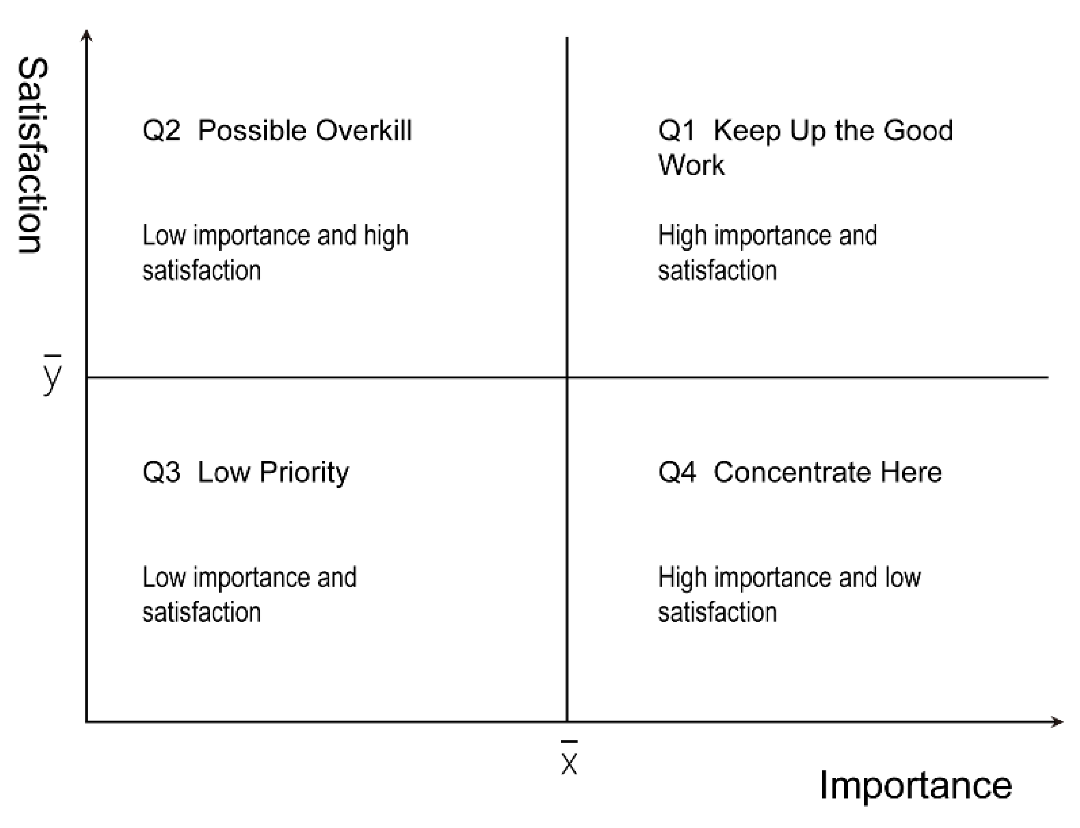
Figure 1. Schematic diagram of the IPA model.
Land 11 00547 g001
Figure 2. Evaluation framework for the health-promotion capacity of greenway trails.
Land 11 00547 g002
Figure 3. Overview of the QLG-I Trail.
Land 11 00547 g003
Figure 4. Interpolation analysis of four target points with walking. (a) kriging interpolation graph at point A; (b) kriging interpolation graph at point B; (c) kriging interpolation graph of point C; (d) kriging interpolation graph of point D.
Land 11 00547 g004
Figure 5. Interpolation analysis of four target points with cycling. (a) kriging interpolation graph at point A; (b) kriging interpolation graph at point B; (c) kriging interpolation graph of point C; (d) kriging interpolation graph of point D.
Land 11 00547 g005
Figure 6. The service scope of the QLG-I Trail for promoting healthy travel.
Land 11 00547 g006
Figure 7. Scatter plot of the QLG-I Trail IPA evaluation.
Land 11 00547 g007
Table 1. The 15 min travel data statistics at the target point.
Target Point NameNumber of Sample Points in the BufferWalkingCycling
S (km2)nS (km2)n
A16222.189029.131175
B16890.84817.74700
C15960.5558.7150
D15920.93155.7848
Total (de-duplication)21164.3511329.211175
Table 2. User attributes and use characteristics of the QLG-I Trail.
CategoryPercentage (%) CategoryPercentage (%)
GenderFemale51.2Frequency of UseEvery day24.9
Male48.8Multiple times a week37.8
Age Group<181.0Once a week14.9
18–3549.3Once a month11.4
36–5536.3Less than once a month10.9
>5513.4TransportationWalking50.2
ResidenceAround the greenway42.8Cycling27.9
Downtown45.8Public transit4.5
Outside of the Lin’an District, in downtown Hangzhou7.5Driving17.4
Outside of Hangzhou city and other areas within Zhejiang Province2.5Time Period of UseBefore 7:008.0
Outside of Zhejiang Province1.57:00–9:0033.3
9:00–13:006.0
13:00–17:005.5
17:00–20:0046.3
After 20:001.0
Table 3. Statistics of the health perceptions of QLG-I Trail users.
Q: Do You Think You Need Physical Exercise?Exercise Very NecessaryNecessaryComparatively NecessaryNormalNo Need
Frequency689619153
Percentage (%)33.847.89.57.51.5
Table 4. Health-promoting behaviour type statistics of QLG-I Trail users.
ClassificationSpecific ContentsPercentage (%)
Physical exerciseWalking, running, cycling, and yoga40.8
Social interactionChatting, parties, team activities, and playing with children8.1
Entertainment and leisureHanging out, walking the dog, fishing, taking pictures, picnicking, and taking a nap15.3
Natural experienceEnjoying the sunset, listening to the calls of insects and birds, and smelling the fragrance of flowers28.1
OthersTraffic, maintenance, work, study, and inspection7.8
Table 5. Fisher’s exact probability test of different populations and health-promoting behaviours.
CategoryHealth-Promoting BehavioursFisher’s Exact Probability Method Test Valuep Value
Physical ExerciseSocial
Interaction
Entertainment and LeisureNatural
Experience
GenderFemale79 (43.4%)17 (9.3%)34 (18.7%)52 (28.6%)1.5950.665
Male78 (45.1%)14 (8.1%)25 (14.5%)56 (32.4%)
Age Group<3579 (43.2%)16 (8.7%)32 (17.5%)56 (30.6%)2.3330.893
36–5557 (46.0%)10 (8.1%)22 (17.7%)35 (28.2%)
>5521 (43.8%)5 (10.4%)5 (10.4%)17 (35.4%)
ResidenceAround the greenway75 (47.5%)12 (7.6%)26 (16.5%)45 (28.5%)12.5750.045 1
Downtown66 (41.3%)17 (10.6%)29 (18.1%)48 (30.0%)
Outside downtown6 (18.2%)2 (6.1%)8 (24.2%)17 (51.5%)
1 p < 0.05, showing that the results reject the null hypothesis and that the Fisher exact probability test results are significantly different.
Table 6. The means and standard deviations of the importance perception and satisfaction evaluation scores of the index factors.
Evaluation
Factors
Index FactorsImportance PerceptionSatisfaction Evaluation
Average ± Standard DeviationOverall AverageAverage ± Standard DeviationOverall Average
Road qualityS1 Width4.22 ± 0.624.434.02 ± 0.613.94
S2 Comfort of pavement for people4.57 ± 0.584.21 ± 0.61
S3 Connectivity with other branches4.19 ± 0.674.02 ± 0.61
S4 Protective fence4.64 ± 0.623.74 ± 0.86
S5 Wheelchair accessible4.55 ± 0.663.73 ± 0.90
Supporting
facilities
S6 Signage system4.30 ± 0.694.114.02 ± 0.703.46
S7 Parking lot3.96 ± 0.762.99 ± 1.08
S8 Lighting system4.34 ± 0.673.79 ± 0.74
S9 Commercial service facilities3.80 ± 0.743.36 ± 0.78
S10 Public health4.16 ± 0.663.16 ± 1.02
Natural
environment
S11 Terrain diversity4.35 ± 0.724.374.24 ± 0.574.33
S12 Colourful plant landscape4.50 ± 0.674.39 ± 0.64
S13 Scenery line4.30 ± 0.744.35 ± 0.59
S14 Meteorological landscape4.36 ± 0.724.36 ± 0.62
S15 Biological landscape4.32 ± 0.694.30 ± 0.64
Regional cultural characteristicsS16 Greenway theme reflects4.05 ± 0.773.634.19 ± 0.564.08
S17 Historical allusions3.63 ± 0.974.13 ± 0.66
S18 Traditional construction techniques3.25 ± 1.113.98 ± 0.68
S19 Application of local materials3.19 ± 1.154.00 ± 0.64
S20 Sense of belonging4.01 ± 0.764.11 ± 0.67
Management and maintenanceS21 Cleanliness4.58 ± 0.604.473.53 ± 1.023.83
S22 Security guards patrol4.52 ± 0.603.73 ± 0.82
S23 The facilities are fully equipped4.34 ± 0.673.99 ± 0.73
S24 Plant conservation4.35 ± 0.674.14 ± 0.67
S25 Fire safety4.57 ± 0.613.75 ± 0.98
Publisher’s Note: MDPI stays neutral with regard to jurisdictional claims in published maps and institutional affiliations.