1. Introduction
Land degradation is a global challenge that is caused by climate change-induced disasters and anthropogenic activities such as urbanization, unsustainable agricultural activities, deforestation as well as loss of native biodiversity [
1]. Sustainable Land Management (SLM) practices are seen as a solution for mitigating land degradation [
2]. SLM is the rational utilization of land and its related resources to produce goods and services that enhance human life without jeopardizing the land’s long-term productive potential and environmental functions [
3]. However, no matter how effective SLM practices are, land users’ decisions to ultimately adopt and continuously implement them or not will determine their success in combating land degradation. In this regard, it is evident that the slow uptake of SLM practices as compared to the fast progression of land degradation has so far hindered the achievement of degradation neutrality in many places [
4].
Invasion by alien plant species such as
Prosopis juliflora (Sw.) DC. (hereafter referred to as
Prosopis) is a particular form of land degradation—one with severe adverse impacts, including the loss of biodiversity [
5], encroachment of agricultural and pasture lands [
6], and depletion of ground and surface water [
7,
8]. Recent studies have stressed the urgency to sustainably manage
Prosopis invasion following its steady increase in cover and its adverse impacts on ecosystems and human livelihoods [
8,
9]. Even though the threat of invasive alien species (IAS) is explicitly addressed in the 2030 Agenda (Target 15.8), it does not seem to get the same attention as other forms of land degradation such as soil erosion, deforestation, or desertification [
10]. Studies on the adoption and continued use of SLM practices [
11,
12] focus on the management of these other forms of degradation by single land users on isolated or individualized parcels of land. This makes them ineffective for managing IAS, which have complex invasion processes, spreading over large tracks of land within short periods of time.
Owing to the complexity, speed, and extent of invasion processes, the management of IAS often demands a coordinated strategy beyond an individual land user’s plot and reach. Such a strategy must combine various approaches in a spatially differentiated manner: prevention, early detection and rapid response, control of invasive species as well as the rehabilitation of cleared land. This requires coordination at the community or landscape level rather than at the farm or household level [
13]. For example, communities in the invaded area and neighboring communities in areas that have not yet been invaded must consensually agree on a management approach that addresses the spatial differences of invasion levels among or between the communities [
14]. This is attributed to variations in the spread and density of
Prosopis, necessitating different management objectives and different investments in management. Strategies for managing IAS such as
Prosopis also require collective decisions on whether to invest or not in the adoption and continued use of IAS management practices [
1,
15].
The need to understand drivers that influence land users’ management decisions and their mutual linkages is widely acknowledged as vital for informing sustainable invasion management strategies. Thus, previous studies [
14,
16,
17] have identified governance decisions, environmental conditions, and social and economic dynamics as the key drivers of invasion management. These drivers are multi-dimensional and have complex systemic interactions, making it necessary to adopt a holistic approach to addressing them [
11,
16]. However, to inform spatially explicit management approaches at a landscape level, there is a need to contextualize these drivers based on their spatiotemporal extent.
To address the above-mentioned challenges, this paper aimed to assess the drivers of land users’ management decisions with respect to IAS management. Based on the spatiotemporal trajectories of Prosopis cover in a case study area—Marigat Sub-County, Baringo County in Kenya—we assess the drivers of land users’ uptake and continued use of SLM practices aimed at managing Prosopis invasion. We also identify promising entry points for the uptake and continued use of SLMs in the context of IAS management. Finally, we derive key lessons from a successful implementation of national and sub-national IAS management strategies such as the recently launched Kenya National Prosopis Strategy. Owing to the associated high costs of managing invasive species, this paper presumes that land users are likely to engage in invasion management only if the benefits derived substantially exceed the cost of management. Likewise, considering the complex invasion pattern of IAS, we predict that sustainable management may be attained through a joint communal action at the landscape level rather than at the individual farm level.
2. Materials and Methods
2.1. Study Area
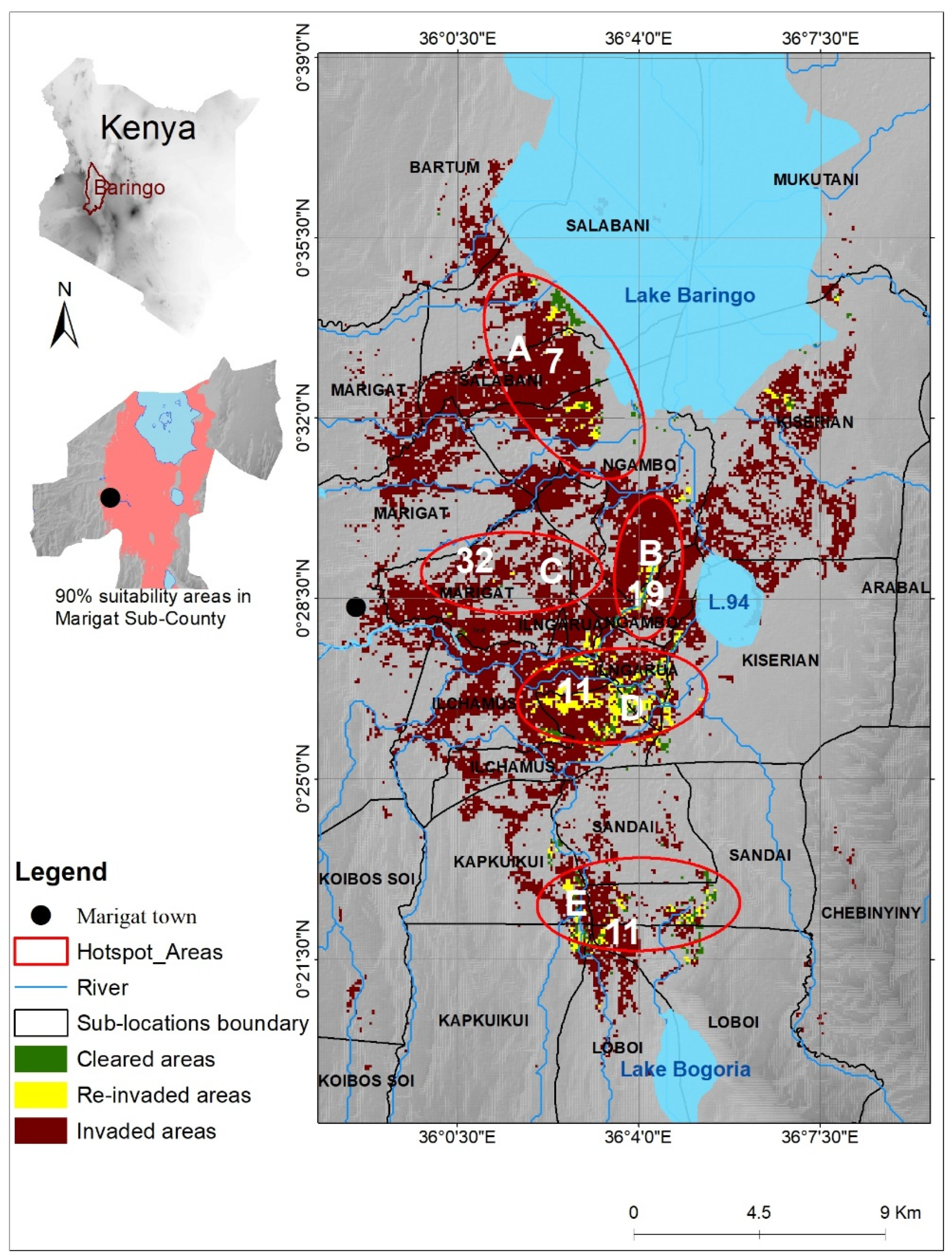
The study was conducted in Marigat Sub-County (
Figure 1), in the eastern lowlands of Baringo County, Kenya (11,075 km
2). Marigat was selected because it is representative of a densely invaded agro-pastoral area that has experienced a substantial impact on local rural livelihoods. Since the 1980s, the native vegetation—trees such as
Vachellia tortillis,
Boscia spp。, and
Balanites aegyptiae as well as native grass species and shrubs such as
Salvadora spp.—has been severely invaded and displaced by
Prosopis [
9,
18].
Prosopis stands in Baringo County are mainly confined to Marigat sub-county [
19].
The annual rainfall in Baringo ranges between 600 mm and 650 mm, with annual average temperatures of 30–35 °C; the area is dominated by andosols (young volcanic soils) [
20,
21,
22]. The population of Marigat Sub-County is just above 100,000, with nine out of ten inhabitants being rural dwellers [
23]. While pastoralism is the primary source of livelihood, furrow irrigation agriculture is prominent and is practiced in areas adjacent to water bodies [
19]. The area is dominated by rangelands, which cover 47.25%, while farming, a major form of livelihood diversification, constitutes 21.7% of the land cover. Water bodies, settlements, forests, and bare land cover 9.7%, 9.6%, 8.4%, and 3.3% of the area, respectively [
21]. De jure, most of the land in Marigat is strictly communal, but de facto, a large percentage is privately claimed [
24].
2.2. Conceptual Framework
We have adopted a systemic conceptual approach to identify and evaluate the interaction among drivers of land users’ decisions on whether to adopt and continually use SLM practices or not in the context of
Prosopis management. We consider drivers as positive when they promote the implementation of SLMs, while negative drivers limit SLM implementation by land users. This approach is informed by the human actors’ model [
25], which emphasizes the crucial role of actors in development outcomes. The conceptual framework is founded on the acknowledgment of actors such as land users, who are the key agents of transformation in any form of development. Thus, the human actors’ model is structured based on three main ideologies—that actors’ decisions to create change are an interplay of three factors: (1) their prioritized activities, (2) their understanding of the effects of those activities on their desired outcomes, and (3) the availability of means needed for them to implement their prioritized activities. This actors’ strategy of actions is non-linear and dynamic. For instance, an undesired outcome of actors’ activities may change the meanings of such activities, leading to modifications of the activities or the re-assignment of their available means to other activities.
The model also considers external and dynamic conditions (environmental, political, economic, and social) as being important in determining actors’ actions and in influencing their activities and stock of means—finances, technology, knowledge, and skills. Similar to the strategy of actions explained above, the effect of these dynamic conditions depends on actors’ perceptions, beliefs, and values. Their outcome leads to either the adaptation or modification of activities to fit into, improve, or stabilize the dynamic conditions.
The actors’ model, therefore, illustrates that actors’ strategies of actions are strongly embedded in their social and cultural institutions as defined by their beliefs, rules, and regulations as well as by the enforcement of such institutions. This is because such institutions define their perceptions, valuations, and meaning of actions. We adapted the model to assist in identifying relevant entry points to address the effect of negative drivers and to evaluate possible pathways for attaining sustainable management strategies.
2.3. Data Collection and Analysis
2.3.1. Data Collection
We spatially structured data collection based on the occurrence of three different temporal patterns of Prosopis invasion:
Areas that were cleared of Prosopis and never re-invaded, indicating land users’ willingness and efforts to continuously implement SLM practices.
Areas that were cleared but later re-invaded, denoting the uptake and subsequent abandonment of SLM practices by land users.
Areas that were never cleared since they were first invaded, suggesting that land users never implemented or tried but failed to implement SLM practices that would help to manage invasion.
Based on the data from [
9], five spatial “hotspot areas” were identified with visual evidence of all three invasion patterns above. The five hotspot areas were distributed over eight sub-locations, which are the lowest of the administrative units in Kenya. In total, eighty land users from these eight sub-locations were interviewed, with the number of interviewees proportional to the population size in each of the sub-locations (
Figure 2). Details of the distribution of sample size proportionate to the population of respective sub-locations are found in
Appendix A.
Three large-scale maps, each illustrating one of the three
Prosopis invasion patterns, were produced for each of the five hotspot areas (see
Figures S1–S15, Supplementary Material) and used during the interviews. The three patterns of
Prosopis presence/absence were explained, and each interviewee was asked to respond to open-ended questions relating to drivers contributing to these patterns in the hotspot areas falling within his/her sub-location. This was to assist in assessing differences in responses from different sub-locations, which were associated with different invasion levels. The level of invasion per sub-location was derived from [
9]’s fractional cover dataset. A 40% fractional cover, beyond which it is often perceived impossible to sustainably control invasion, was used as a cut-off point for densely and sparsely invaded areas. Advanced invasion is used in this paper to refer to a perceived invasion level beyond which respondents considered SLM implementation to be impossible or meaningless as the associated management costs would exceed the benefits to be derived from management efforts. The main guiding questions for the interviews were as follows:
Do you agree that the general pattern of Prosopis cover in your sub-location is accurately represented on the map? This question was to confirm the occurrence of the three spatial-temporal patterns that reflect different scenarios of adoption and continued use of SLM practices. Any contradicting opinion was noted and clarification/revision of patterns was sought.
What are the factors that could have contributed to the occurrence of the respective patterns? Respondents were expected to reflect on all factors they could think of while answering this open-ended question.
In addition to the questions on drivers, we obtained details regarding the parcels that the land users owned, such as the previous and current land cover/use and the approximate distance of the farms from their homesteads. We later validated the findings by interviewing all the area chiefs using the same questionnaires in order to clarify aspects that seemed ambiguous.
2.3.2. Data Analysis
Responses to the open-ended questions and the corresponding socio-demographic data from the survey were entered into MS Excel, combined to form a single string ID, and converted into a text format before being exported to ATLAS.ti for analysis (
Appendix B). Responses were then coded and categorized into related thematic codes falling within four distinct categories of drivers that influence the uptake and continued use of SLM practices: socio-cultural, environmental, economic, and political drivers. The process of assigning a code to each response was limited to the interviewer’s understanding of the subject matter and the context under which each response was given. To avoid a misinterpretation of the responses and thus the assignment of the wrong codes, the researcher was present at each interview to seek clarification for the responses that might have been unclear.
The dataset was then entered into c-coefficient tables to analyze the association between codes, depending on whether the codes would co-occur whenever they were assigned to a quotation or response. The c-coefficients range from 0, for codes that do not co-occur, to 1, for codes that are always assigned to the same quotation or response. The c-coefficient (c), also known as the c-index, is calculated as follows:
where
n1 and
n2 are the occurrence frequency of two co-occurring codes—
c1 and
c2—while
n1,2 is the co-occurrence frequency of the two codes.
The output was displayed in network views that visualized the relationship between and among the codes. The codes in the network view were organized depending on their groundedness—the number of quotations/responses assigned to them—to illustrate their hierarchical significance. Some quotations/responses had multiple meanings and were hence assigned to more than one code. For instance, a decision to seek an alternative source of income due to drought was assigned two codes: livelihood diversification and natural disasters. In such a case, the two codes were linked to the same quotation/response. The number of linkages to a code is denoted as its density (D) and is displayed in the network view. According to [
26], only the values of a code’s groundedness are relevant in determining the significance of a code; the higher the value, the more number of times that code was mentioned.
The application of c-indices is instrumental in depicting the association between codes in that it performs a quantitative analysis of qualitative data [
26]. However, their values may not reflect the actual strength of association, especially if the codes are distorted by unequal frequencies [
27]. Therefore, while c-index values close to one indicate a strong association, two codes varying greatly in frequency (usually if the ratio between the two frequencies is greater than five) may also reveal a strong association at a considerably lower value. This is indicated by c-indices highlighted in the co-occurrence coefficient tables (
Appendix B). Our data were distorted by variations in frequencies since each respondent was free to mention as many drivers of a particular invasion trend as he or she wished. To enable a comparison between and among the codes, the c-indices were multiplied by a system-generated factor to normalize them. The ATLAS.ti software automatically highlights significant c-indices if their low values are associated with such distortions [
27]. This simplified the selection of codes, whose co-occurrence was significant for our analyses.
4. Discussion
This study has shown that land users’ decisions to implement SLM practices to manage
Prosopis in Baringo County are reflected in patterns of invasion, and that such decisions are influenced by socio-cultural, economic, environmental, and political drivers. Continuous cultivation was found to be the main factor contributing to invasion management. Even so, this depends on land users’ motivation and ability to access resources for SLM implementation [
17]. Thus, the key drivers of continuous SLM implementation are timely access to appropriate information on the need to manage invasion as well as the provision of incentives, financial resources, and favorable market dynamics [
28,
29].
Unlike the positive drivers, the negative drivers are numerous, diverse, and limit the performance of the positive drivers. Addressing the negative drivers should therefore be prioritized to achieve sustainability in the management of invasive species. Hence, we will first discuss the causal linkages among negative drivers and their association with critical socio-ecological factors that limit SLM adoption and continued implementation (
Figure 8). The study applied the local actors’ model as an explanatory framework for relating how linkages among different drivers provide a rationale for land users’ management decisions.
4.1. Critical Socio-Ecological Factors Associated with Non-Adoption and Abandonment of SLM Practices
The four main factors associated with non-adoption and abandonment of SLMs are: livelihood adaptation, market uncertainties, environmental disruptions, and the disconnect between research and land governance. These factors are important in informing management strategies as the failure to address them may limit SLM implementation and hinder the successful management of invasive species. We hereby describe each of them in relation to their causal drivers.
4.1.1. Environmental Disruptions
These include natural disasters such as drought and floods, which result in low productivity or crop failures. Such events tend to increase in the wake of global climate change [
30]. They result in low returns compared to the cost of SLM implementation [
31], thus leading to the abandonment of affected parcels as land users are unwilling to continue implementing SLM practices on them. This exposes initially managed parcels to invasion or re-invasion. Based on the land users’ experience, they believe that environmental shocks adversely impact the outcome of their SLM implementation. These beliefs and perceptions of the impact of external drivers on land users’ expected returns inform their land management decisions, as indicated in the human actors’ model [
25]. In this case, the land users’ perceptions discourage the implementation of SLMs, hence limiting invasion management.
4.1.2. Market Uncertainty
Under contractual farming, which is dominant in the irrigation zone of the study area, land users sell their produce to the contracting companies, the NIB, who were reported to dictate the prices and sometimes purchase below market price. A decrease in demand for agricultural products and its effect on prices are also a disincentive to SLM implementation.
As explained in the actors’ model, the land users’ rationale for assigning their stock of means to alternative activities is exposed to dynamic factors, including the economic drivers [
25]. Thus, land users perceive that market dynamics result in low returns despite their implementation of SLMs. Consequently, they adapt by re-assigning their available stock of resources to other promising economic activities [
32]. This is illustrated by the fact that land users opt to discontinue farming activities and channel their resources to alternative means of survival when they perceive that their returns will be lower than the costs of farm inputs. This also exposes the abandoned parcels to re-invasion.
4.1.3. Livelihood Adaptation
Contrary to the initial purpose of its introduction as, among other things, a source of fodder for livestock [
33],
Prosopis has led to the loss of herbaceous biomass, resulting in the decline of livestock numbers [
34]. Coupled with high invasion management costs and the impacts of prevailing environmental disruptions such as drought and floods, land users gradually adapt and transition to alternative sources of livelihood such as trade, charcoal production, or employment. Land users’ motivation to implement SLM practices on their lands therefore declines [
31], leaving affected parcels exposed to invasion. This indicates that the exposure of land users’ actions to external conditions such as environmental disturbances influences them to adapt their activities to the prevailing conditions [
25,
35]. According to [
6], the income from alternative livelihoods such as charcoal production may not replace the cultural value bestowed upon pastoralism. Thus, the main reason for community members’ diversification to other livelihood sources may be due to the degradation of their initial grazing field upon which their livestock depended. This implies that the restoration of grazing fields presents the possibility of promoting the engagement of land users in communal land management.
4.1.4. The Disconnect between Research and Land Governance
In the absence of an effective science-policy interface, evidence from science does not or only slowly finds its way into land governance decisions. This results in two main factors that limit land management, specifically within communal tenure systems: dysfunctional extension services and ineffective land governance practices. Reliance on extension services that are not guided by credible research findings misleads land users’ actions. Likewise, the delay of extension services limits timely response actions [
32], which then enhances the progression of invasion to advanced levels, during which it will be impossible to manage invasion [
13].
The land governance systems in place were perceived to be ineffective in addressing the prevailing tenure issues. The customary land acquisition process was associated with land fragmentation, which has been associated with technical inefficiencies in croplands [
36]. In addition, weak land governance institutions have led to unresolved land disputes. This, in turn, has discouraged community members from holding themselves accountable for managing land due to a lack of incentives. As demonstrated in the human actors’ model, community perceptions and practices are strongly embedded within their social and cultural institutions. This requires that interventions aimed at addressing land management issues should focus on reinforcing these institutional frameworks or modifying them in order to support sustainable environmental management [
25].
Based on the four factors above that hinder SLM implementation, we compare our findings with a South African study, which is among studies that explicitly focus on barriers to the management of
Prosopis [
16]. Both studies found that land users’ decisions are shaped by drivers of multiple dimensions ranging from economic, social, political, and environmental, with the social drivers being the most dominant. The main difference is that the current findings are contextualized on specific patterns of invasion as determined by successive presence /absence of
Prosopis. Therefore, ours advances the previous study by offering context-based drivers of invasion management by land users. In addition to the institutional and knowledge gaps identified by [
16], our findings focused on ineffective land governance, environmental disruptions, livelihood adaptations, and the science-policy gap as key challenges to IAS management.
In contrast to [
16]’s study, our respondents did not mention a lack of technical knowledge about the effectiveness and cost implications of alternative control options such as biological and chemical control methods. This shows that respondents in South Africa were better acquainted with different options for IAS management as compared to those in our Kenyan study. According to [
17], successful management strategies involve a combination of practices. However, the land users’ rationale for applying multiple alternatives in managing invasion is determined by their knowledge and experience with such diverse practices [
28]. This is because land users tend to adopt practices whose success rates they are well-acquainted with. However, to date, measures for managing
Prosopis by chemical and biological means have not yet been made available in Baringo County. This is despite reports from previous studies explaining that biological control has the benefit that it is a “natural” management approach and does not require continuous implementation by individual land users [
13,
37]. Therefore, there is a need for land users to benchmark their own practice against that of implementers of alternative management practices as this may widen their knowledge and encourage them to take initiatives in their implementation.
Both studies also observed that benefits from
Prosopis have been associated with the reluctance of land users to manage it. In this study, this challenge was majorly associated with the sparsely invaded areas, where respondents had limited experience with the high clearance costs associated with advanced invasion [
17]. The failure of these land users to learn from the experiences of those coming from heavily invaded areas was mentioned as a challenge that hindered timely invasion control in the South African study.
4.2. Potential Entry Points for Sustainable IAS Management
The management of IAS such as
Prosopis cannot be accomplished at the plot level. To be successful, it must be jointly implemented by multiple stakeholders on both privately and communally owned land and at the landscape scale [
13,
17]. Therefore, to promote the implementation of SLM practices and hence sustainably manage IAS, there is a need to address the main barriers captured in the four underlying factors mentioned above. This will allow for a better performance of the positive drivers towards the higher adoption and continuous implementation of SLM practices for sustainable IAS management. We therefore propose the following entry points for a successful IAS management strategy:
4.2.1. Enhancing Community Resilience to Environmental Disruptions
Based on our findings, the most viable entry point to address environmental disruptions should aim at convincing land users that the outcome of environmental disruptions does not necessarily have to render their management efforts futile. This calls for enhanced community resilience to environmental disturbances, which are associated with far-reaching impacts, often beyond the capacity of the local community to respond effectively. Building local capacity and strengthening community resilience need to depart from the traditional practice of targeting external support and should instead explore the options of adapting activities in order to minimize uncertainty or modify the dynamic conditions within which the actors operate. The latter is likely to yield more effective outcomes [
25]. Thus, external support from governments and institutions in establishing infrastructures and building capacity to enhance resilience to natural disasters is a key aspect of early preparedness. However, modifying the conditions within which land users operate is likely to enhance their resilience. For instance, since resilience to natural disasters can be better attained through collective rather than individual actions [
29], well-established social networks at the community level are likely to reinforce community capacity to organize themselves, learn from experiences with disturbances, and adopt the appropriate mechanisms to recover and adapt to shocks [
38].
In the response to extreme events, especially in croplands where losses may be inevitable despite improved infrastructure, robust insurance schemes and effective programs for the compensation of losses are also necessary. Such measures enhance resilience against shocks, which foster land users’ continued engagement in the implementation of SLM practices [
11,
38]. Apart from enhancing resilience, the establishment and enforcement of appropriate land use plans are necessary for restricting human activities in disaster-prone zones. This is particularly relevant to areas along rivers and in other flood-prone areas, which are often selected for farming due to water availability. Therefore, strengthening community-based institutions may be pivotal in enforcing land-use plans [
14]. This is because land users’ actions and behaviors are embedded within their socially-defined institutions [
17].
4.2.2. Price Control and Regulation of Market Actors
Price control and the regulation of market actors are required to create a fair environment and to guarantee sufficient returns to smallholders, which is a key condition for them to sustainably implement SLM practices. The enforcement of an adequate regulatory framework for community members that strives to minimize the risk of their exploitation is central. The formulation of policies that uniformly regulate market prices and enhance equitable access to available markets may minimize monopolization by contracting institutions, hence checking the exploitation of land users [
36]. To achieve this, it is important to integrate land users—through farmers’ cooperatives which advocate for enhanced farmers’ rights in terms of price control—and their access to markets. Such cooperatives should focus on creating an environment that favors a competitive market for farmers’ produce rather than restricting them to a single market outlet. This way, land users may be sure of benefiting from their efforts and thus continue with SLM implementation.
4.2.3. Integrating Environmental Management with Poverty Alleviation
The findings of our study confirm the need to integrate environmental management with poverty alleviation [
39] as communities tend to modernize their livelihoods with new and attractive income opportunities. A promising entry point in this regard would be to prioritize livelihood activities that are dependent on SLM implementation; for example, by taking farming as a primary rather than a supplementary source of livelihood, as indicated in the County Development Plan [
19]. However, the promotion of such land-dependent economic activities would require access to land and water resources. Consequently, there would be a need to establish flexible land markets that promote the re-distribution of parcels to people who would convert their purpose to meaningful uses and prevent (re-)invasion. This approach, however, does not address the management of communally shared parcels such as roadsides and rangelands, which are prone to abandonment and invasion.
Land subdivision, although useful in managing individual parcels in the face of increasing population, adversely affects IAS management at a landscape level. This was illustrated in California, where only some landowners managed the invasive yellow starthistle (
Centaurea solstitialis) on their parcels; the parcels whose owners opted not to manage the weed acted as a source of invader propagules [
14]. This shows that the management of communally shared resources such as rangelands requires collective action that incorporates all users. Indeed, it has been reported that land users tend to adopt practices in solidarity with community collective action within which their actions and beliefs are embedded [
17] as long as social relationships and trust are built among the concerned land managers [
28]. As such, a probable solution may be to replant communally shared lands with native tree and grass species under the stewardship of assigned community members. Their engagement may be secured if their efforts are rewarded through a compensation scheme and village development programs such as the establishment of infrastructure as well as by securing and enforcing land use rights. This ensures that environmental management is integrated with social and economic development and with benefits that contribute to poverty reduction among the affected communities. To enhance collective participation, social sanctions on non-participating members have been reported to yield effective cooperation among community members [
17].
Likewise, the harmonization of policies across sectors (from agricultural and environmental to trade) and scales (from local to national levels) is needed. For instance, the simultaneous occurrence of a market opportunity (for charcoal), policy provisions for the easier licensing of charcoal trade, and the need to diversify livelihoods away from farming activities all lead to a positive perception of
Prosopis, thus promoting its utilization rather than control. The harmonization of such diverse policy instruments is necessary for designing effective management strategies. This is consistent with the logic that meaningful outcomes of actors’ actions should holistically integrate their activities, their means for achieving such activities, and the meanings or interpretations of the outcomes of their actions [
25]. Therefore, enhancing access to land (means), coupled with the perceived outcome of alleviating poverty (meaning of actions) through farming activities (actors’ activity) provides a sound entry point for sustainable environmental management.
4.2.4. Community Mobilization and Awareness Creation
The findings of this study indicate that scientific evidence is fundamental for informing land governance concerning IAS management as it helps in identifying factors that influence land users’ adoption of SLM practices as well as the areas where management should be prioritized. For instance, we found that communally owned land and irrigation schemes are vulnerable to invasion, thus necessitating robust management measures in order to prevent further spread in these areas.
Even though efforts have been made to disseminate research findings to community members, we propose that innovative extension service approaches be used to help promote communal actions—through the engagement of the community members in reflecting on the benefits and nuisances of ecosystem services generated by different land management practices and how to integrate stakeholder needs with sustainable environmental management at the landscape scale. Likewise, the use of demonstration plots, the introduction of attractive community field days, and the appreciation of SLM champions may not only motivate community participation in SLM practices but also provide an interactive platform for the widespread dissemination and exchange of research innovations [
40]. These concur with a study in Mongolia that found that integrating diverse sources of information enhances knowledge exchange, which then promotes rangeland management [
41].
4.2.5. Effective Land Governance Solutions
Apart from awareness creation, the enforcement of tenure rights may provide land governance solutions and support invasion management. According to [
12], a consolidated land ownership approach is indispensable for improving access to land and simplifying land management. This may be achieved if flexible land markets are established to encourage transactions in parcels that are vulnerable to abandonment by their owners. However, this approach is only applicable to individual lands or parcels under customary rights of occupancy, as provided for in the Kenyan Community Land Act, 2016. Nevertheless, managing the often neglected communally shared parcels, which are prone to disputes and neglect, is complex [
42]. Therefore, IAS management at the landscape level is hindered by land subdivisions as land users disregard the management of parcels jointly owned due to a lack of incentives [
14]. Addressing the challenge of joint registration of communally shared resources, as provided for in Kenya’s new Community Land Act, 2016, may yield a positive outcome. Such an approach is likely to promote the collective utilization and management of communal resources by legitimate community members [
43]. This is because it helps in recognizing the legitimate beneficiaries of communally owned resources, thus holding them accountable for their management. A participatory formulation and enforcement of by-laws guiding the use and management of the Simanjiro rangeland in Tanzania is a practical example of successful collective action in integrating IAS control within rangeland management [
44]. As identified in our research, the benefits achieved thereof are a great incentive that determines whether land users will manage invasion or not. This means that for communally shared lands to be effectively managed, coordinated management has to be integrated with shared benefits for land users [
13,
14].
The above-mentioned interventions may significantly contribute to invasion management if jointly implemented and enforced by community members, who are the agents of change. This requires an effective institutional framework to promote the timely resolution of land-related disputes as well as communal engagement in management measures. To achieve this, efforts should be made to promote coordinated and community-based tenure rights enforcement procedures in order to enhance the legitimacy of enforcement officers in the community where change is needed and for invasion management to be sustainable. The establishment of empowering institutional frameworks and powers at communal levels is likely to enhance the solidarity and collective involvement of community members [
45] in managing the invasion. In this regard, the establishment of communally managed conservancies has proved to be effective in attaining collective communal action in the management of invasive species [
44].
4.3. Lessons Learned and Recommendations to the NPS
The continuous implementation of SLMs is central to the successful management of Prosopis, and this may be sustainable if it is centered around effective communal participation. Despite this, land users’ continued participation depends on whether their efforts will be compensated by benefits derived from management efforts. To enhance anticipated benefits and promote land users’ contribution to managing invasion through the implementation of SLMs, the NPS should incorporate programs aimed at enhancing the resilience of community members to adverse external drivers. Integrating management strategies with the enhancement of land users’ livelihood such as through the increase of access to the market for farm produce is likely to promote land users’ participation in the associated SLM implementation.
This study observed that land management efforts primarily focus on privately owned lands, while the management of communally shared resources is often neglected despite their vulnerability to invasion. The implementation of SLMs to manage invasion therefore depends on the enforcement of tenure rights, whose solutions vary with the nature of the tenure system. Access to the land market is likely to enhance land re-distribution and promote the implementation of SLMs on individual parcels. However, the same challenge on communally shared resources may be best resolved through the collective registration, utilization, and management of land. In both cases, strengthening communal land management institutions plays a pivotal role in effective land governance and invasion management. Nonetheless, such institutions have to be informed by credible research output for them to offer viable solutions to challenges that face the prevailing tenure systems. Thus, the NPS should adopt means of ensuring that land management institutions operate within the guidelines of scientific research output.


 ,
, 