
Quantifying the Spatial Fragmentation Pattern and Its Influencing Factors of Urban Land Use: A Case Study of Pingdingshan City, China

Abstract
:1. Introduction
2. Research Areas and Methods
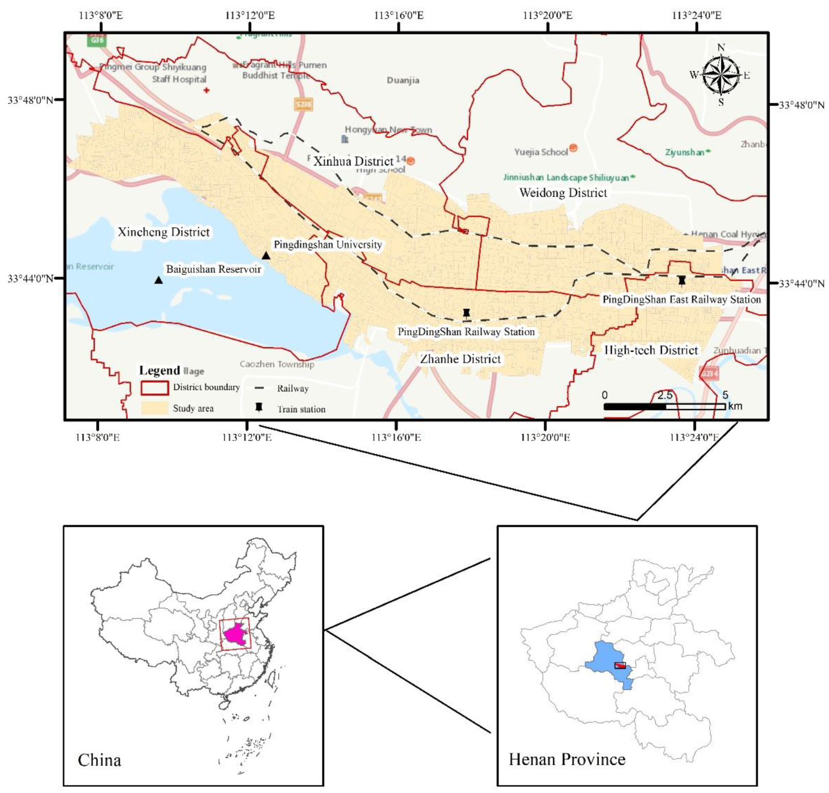
2.1. Study Area
2.2. Data Sources
2.3. Methodology
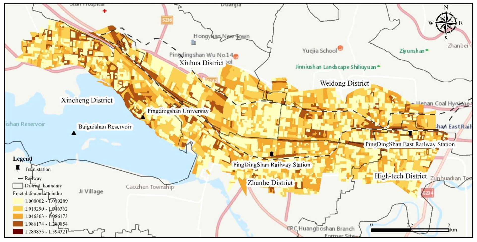
2.3.1. Fractal Dimension Index
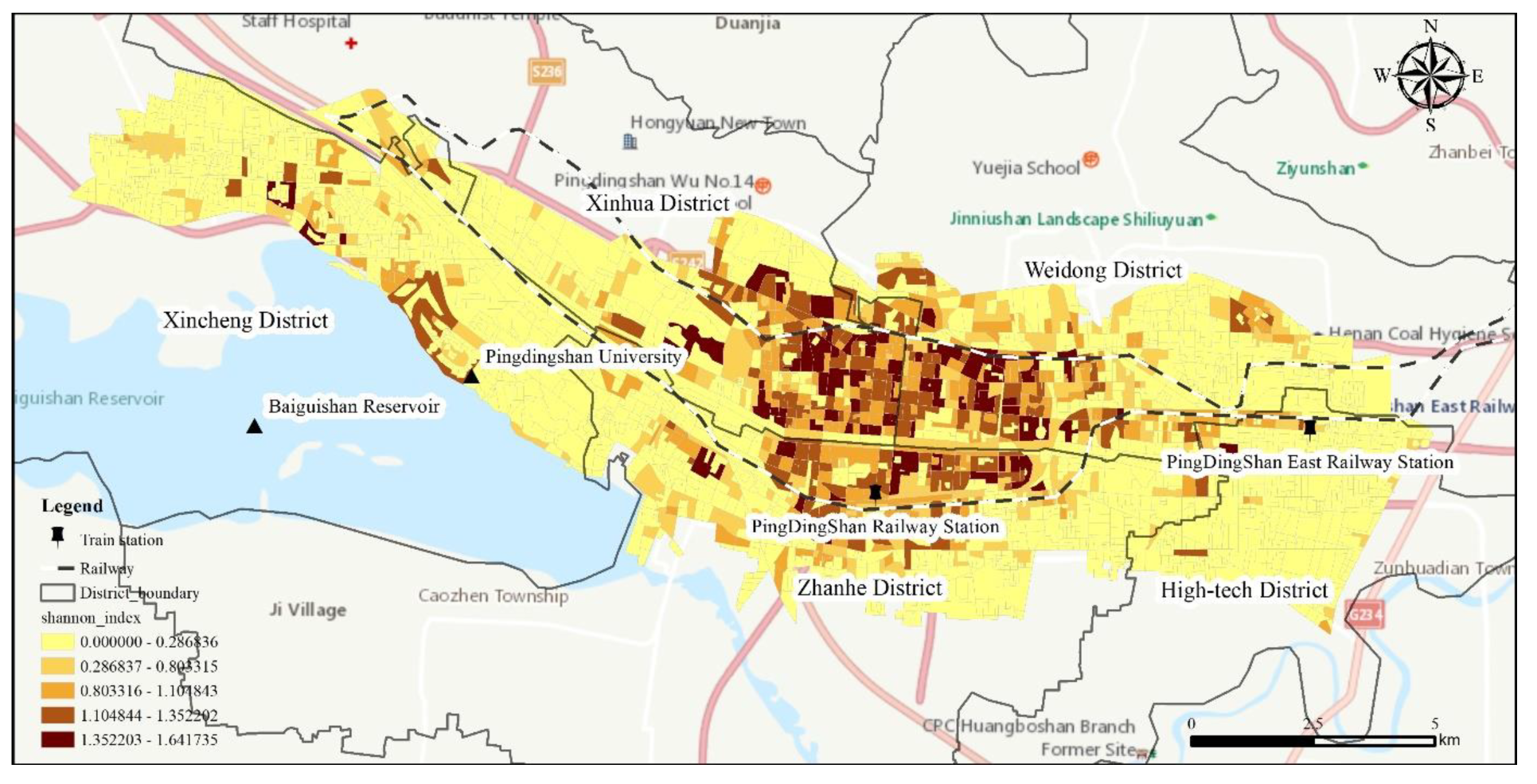
2.3.2. Shannon Index
2.3.3. Cold/Hot Spot Analysis
2.3.4. MGWR Model
3. Results and Analysis
3.1. Fragmentation Pattern of Spatial Form
3.2. Fragmentation Pattern of Spatial Function
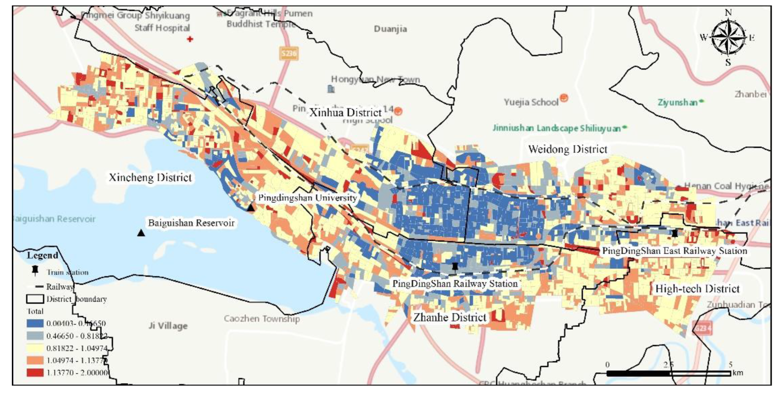
3.3. Comprehensive Fragmentation
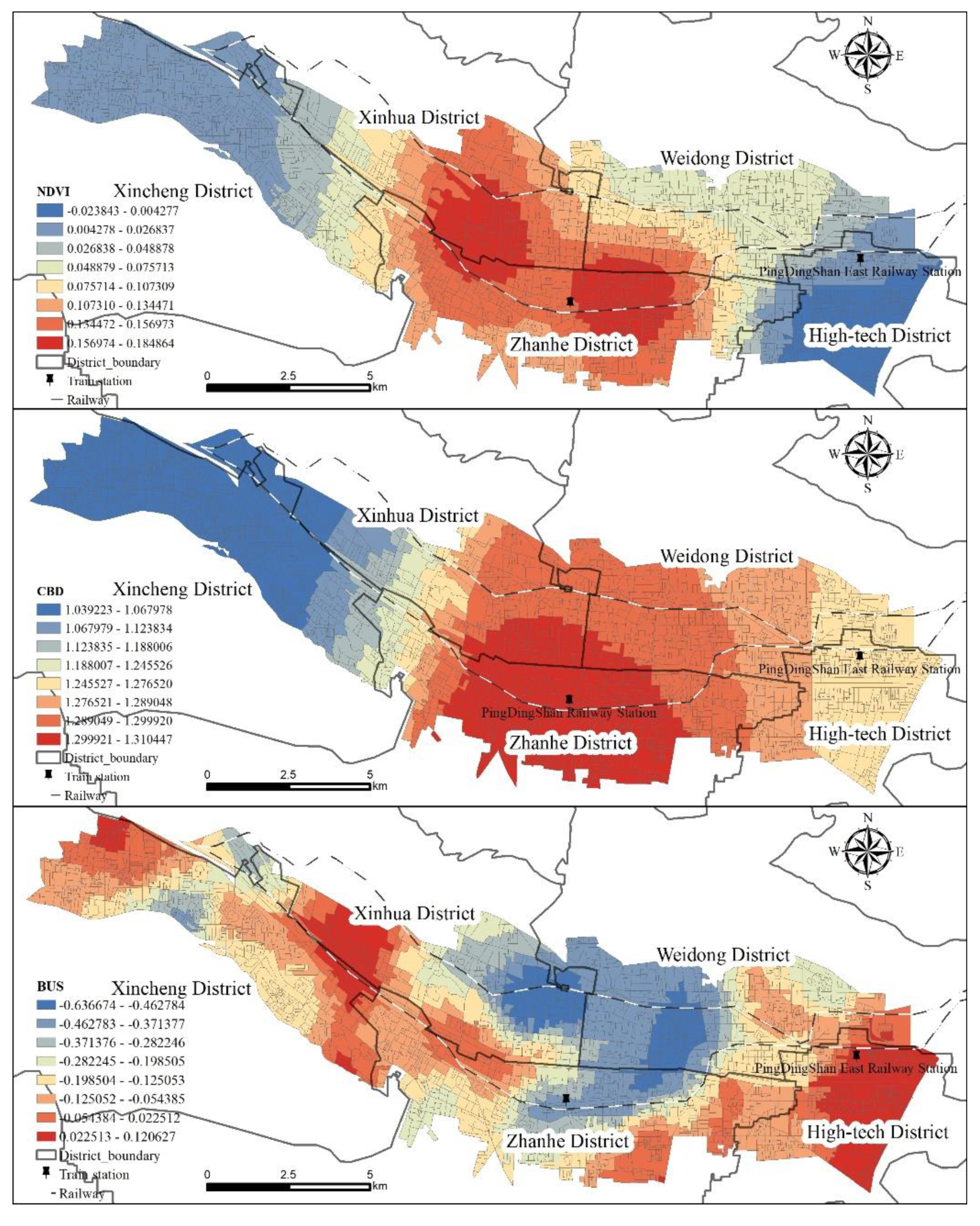
4. Analysis on Influencing Factors of Space Fragmentation
5. Discussion
6. Conclusions
Author Contributions
Funding
Institutional Review Board Statement
Informed Consent Statement
Data Availability Statement
Conflicts of Interest
References
- Gu, C.L.; Wang, F.H. The Structure of Social Space in Beijing in 1998: A Socialist City in Transition. Urban Geogr. 2005, 26, 167–192. [Google Scholar] [CrossRef]
- Feng, J.; Wu, F.L.; Logan, J. From Homogenous to Heterogeneous: The Transformation of Beijing’s Socio-Spatial Structure. Built Environ. 2008, 34, 482–498. [Google Scholar] [CrossRef]
- Falahat, S.; Shirazi, M.R. Spatial fragmentation and bottom-up appropriations: The case of Safavid Isfahan. Urban Hist. 2015, 42, 3–21. [Google Scholar] [CrossRef] [Green Version]
- Gheler-Costa, C.; Lyra-Jorge, M.; Martins Verdade, L. Biodiversity in Agricultural Landscapes of Southeastern Brazil. Walter de Gruyter GmbH & Co KG: Berlin, Germany, 2016; pp. 43–64. [Google Scholar]
- Liang, J.; Liu, Y.; Ying, L.X.; Li, P.; Xu, Y.; Shen, Z.T. Road impacts on spatial patterns of land use and landscape fragmentation in three parallel rivers region, Yunnan Province, China. Chinese Geogr. Sci. 2014, 24, 15–27. [Google Scholar] [CrossRef] [Green Version]
- Li, Z.G.; Wu, F.L. Tenure-based residential segregation in post-reform Chinese cities: A case study of Shanghai. Trans. Inst. Br. Geogr. 2008, 33, 404–419. [Google Scholar] [CrossRef]
- Rosa, I.M.D.; Gabriel, C.; Carreiras, J.M.B. Spatial and temporal dimensions of landscape fragmentation across the Brazilian Amazon. Reg. Environ. Change 2017, 17, 1687–1699. [Google Scholar] [CrossRef] [Green Version]
- Slattery, Z.; Fenner, R. Spatial Analysis of the Drivers, Characteristics, and Effects of Forest Fragmentation. Sustainability 2021, 13, 3246. [Google Scholar] [CrossRef]
- Zhang, S.N.; York, A.M.; Boone, C.G.; Shrestha, M. Methodological Advances in the Spatial Analysis of Land Fragmentation. Prof. Geogr. 2013, 65, 512–526. [Google Scholar] [CrossRef]
- Celemin, J.P. Spatial association between socioeconomic and environmental fragmentation in the city of Mar del Plata, Argentina. EURE-Rev. Latinoam. Estud. Urbano Reg. 2012, 38, 33–51. [Google Scholar]
- Serpa, A. Diversity and inequality in contexts of socio-spatial fragmentation: Advances and retreats. Atelie Geogr. 2018, 12, 22–38. [Google Scholar] [CrossRef] [Green Version]
- Krellenberg, K.; Welz, J.; Link, F.; Barth, K. Urban vulnerability and the contribution of socio-environmental fragmentation: Theoretical and methodological pathways. Prog. Hum. Geogr. 2017, 41, 408–431. [Google Scholar] [CrossRef]
- Hidding, M.C.; Teunissen, A.J.L. Beyond fragmentation: New concepts for urban–rural development. Landsc. Urban Plan. 2002, 58, 297–308. [Google Scholar] [CrossRef]
- Labbé, D.; Boudreau, J.A. Understanding the causes of urban fragmentation in Hanoi: The case of new urban areas. Int. Dev. Plan. Rev. 2011, 33, 273–291. [Google Scholar] [CrossRef]
- Mohamed, A. Towards More Sustainable Urban Forms in the City of Benghazi: A Study of Urban Fragmentation at the Neighbourhood Level; University of Westminster: London, UK, 2013. [Google Scholar]
- Alberti, M. The Effects of Urban Patterns on Ecosystem Function. Int. Reg. Sci. Rev. 2005, 28, 168–192. [Google Scholar] [CrossRef]
- Aguilera, F.; Valenzuela, L.M.; Botequilha-Leitão, A. Landscape metrics in the analysis of urban land use patterns: A case study in a Spanish metropolitan area. Landsc. Urban Plan. 2011, 99, 226–238. [Google Scholar] [CrossRef]
- Felt, C.; Fragkia, M.; Larson, D.; Liao, H.F.; Lohse, K.A. A comparative study of urban fragmentation patterns in small and mid-sized cities of Idaho. Urban Ecosyst. 2018, 21, 805–816. [Google Scholar] [CrossRef]
- Balbo, M.; Navez-Bouchanine, F. Urban fragmentation as a research hypothesis: Rabat-Salé case study. Habitat Int. 1995, 19, 571–582. [Google Scholar] [CrossRef]
- Pessoa, I.T.M. Spatial fragmentation and self-organisation: A negative relationship in Brazilian metropolises. Urbe-Rev. Bras. Gest. Urbana 2019, 11, 79–99. [Google Scholar] [CrossRef]
- Jimmy, E.N.; Martinez, J.; Verplanke, J. Spatial Patterns of Residential Fragmentation and Quality of Life in Nairobi City, Kenya. Appl. Res. Qual. Life 2020, 15, 1493–1517. [Google Scholar] [CrossRef] [Green Version]
- Jaeger, J. Landscape division, splitting index, and effective mesh size: New measures of landscape fragmentation. Landsc. Ecol. 2000, 15, 115–130. [Google Scholar] [CrossRef]
- Luck, M.; Wu, J. A gradient analysis of urban landscape pattern: A case study from the Phoenix metropolitan region, Arizona, USA. Landsc. Ecol. 2002, 17, 327–339. [Google Scholar] [CrossRef]
- Burton, E. Measuring urban compactness in UK towns and cities. Environ. Plan. B Plan. Des. 2016, 29, 219–250. [Google Scholar] [CrossRef]
- Saganeiti, L.; Pilogallo, A.; Scorza, F.; Mussuto, G.; Murgante, B. Spatial Indicators to Evaluate Urban Fragmentation in Basilicata Region. Lect. Notes Comput. Sci. 2018, 10964, 100–112. [Google Scholar]
- Bentley, J.W. Wouldn’t you like to have all of your land in one place? Land fragmentation in Northwest Portugal. Hum. Ecol. 1990, 18, 51–79. [Google Scholar] [CrossRef]
- Krellenberg, K.; Link, F.; Welz, J.; Harris, J.; Barth, K.; Irarrazaval, F. Supporting local adaptation: The contribution of socio-environmental fragmentation to urban vulnerability. Appl. Geogr. 2014, 55, 61–70. [Google Scholar] [CrossRef]
- Fan, C.; Myint, S. A comparison of spatial autocorrelation indices and landscape metrics in measuring urban landscape fragmentation. Landsc. Urban Plan. 2014, 121, 117–128. [Google Scholar] [CrossRef]
- Baldini, C.; Marasas, M.E.; Tittonell, P.; Drozd, A.A. Urban, periurban and horticultural landscapes—Conflict and sustainable planning in La Plata district, Argentina. Land Use Policy 2022, 117, 106120. [Google Scholar] [CrossRef]
- García-Ayllón, S. Predictive Diagnosis of Agricultural Periurban Areas Based on Territorial Indicators: Comparative Landscape Trends of the So-Called “Orchard of Europe”. Sustainability 2018, 10, 1820. [Google Scholar] [CrossRef] [Green Version]
- Low, S. Towards a Theory of Urban Fragmentation: A Cross-Cultural Analysis of Fear, Privatization, and the State. Eur. J. Geogr. 2005, 349, 1–30. [Google Scholar] [CrossRef]
- Bereitschaft, B.; Debbage, K. Regional Variations in Urban Fragmentation among U.S. Metropolitan and Megapolitan Areas. Appl. Spat. Anal. Policy 2014, 7, 119–147. [Google Scholar] [CrossRef]
- Ouyang, X.; Wei, X.; Li, Y.; Wang, X.C.; Klemes, J.J. Impacts of urban land morphology on PM2.5 concentration in the urban agglomerations of China. J. Environ. Manag. 2021, 283, 112000. [Google Scholar] [CrossRef] [PubMed]
- Mulligan, G.F. Fractal cities: A geometry of form and function. Cities 1997, 14, 54–55. [Google Scholar] [CrossRef]
- Shannon, C.E. A Mathematical Theory of Communication. Bell Syst. Tech. J. 1948, 27, 379–423. [Google Scholar] [CrossRef] [Green Version]
- Ma, T.; Jiang, D.; Qu, Z.G.; Xue, C.; Ding, F. Factors influencing the spatial distribution of cystic echinococcosis in Tibet, China. Sci. Total Environ. 2021, 754, 142229. [Google Scholar] [CrossRef] [PubMed]
- Fotheringham, A.S.; Yang, W.B.; Kang, W. Multiscale Geographically Weighted Regression (MGWR). Ann. Am. Assoc. Geogr. 2017, 107, 1247–1265. [Google Scholar] [CrossRef]
- Cao, X.Y.; Shi, Y.S.; Zhou, L.L.; Tao, T.H.; Yang, Q.Q. Analysis of Factors Influencing the Urban Carrying Capacity of the Shanghai Metropolis Based on a Multiscale Geographically Weighted Regression (MGWR) Model. Land 2021, 10, 578. [Google Scholar] [CrossRef]
- Lao, X.; Gu, H.Y.; Yu, H.C.; Xiao, F. Exploring the Spatially-Varying Effects of Human Capital on Urban Innovation in China. Appl. Spat. Anal. Policy 2021, 14, 827–848. [Google Scholar] [CrossRef]
- Gu, H.; Yu, H.; Sachdeva, M.; Liu, Y. Analyzing the distribution of researchers in China: An approach using multiscale geographically weighted regression. Growth Change 2020, 52, 443–459. [Google Scholar] [CrossRef]
- Lao, X.; Gu, H. Unveiling various spatial patterns of determinants of hukou transfer intentions in China: A multi-scale geographically weighted regression approach. Growth Change 2020, 51, 1860–1876. [Google Scholar] [CrossRef]
- Zhu, P.; Lang, Z.; He, Q.; Zhang, M.; Wu, G. The pattern characteristics and influencing factors of urban space fragmentation in Changsha. Geogr. Res. 2020, 39, 1739–1754. [Google Scholar]


| Study Area | Number of Patches | Total Patch Area (km2) | Patch Density (Block/km2) | Minimum Patch Area (km2) | Maximum Patch Area (km2) | Fractal Dimension Index |
|---|---|---|---|---|---|---|
| Pingdingshan built-up area | 2667 | 136.7 | 19.5 | 0.000016 | 0.97 | 1.029 |
| Variable | Meaning |
|---|---|
| DEM | Digital Elevation Model (m) |
| Population density (pop) | Population per unit land area (Person/km2) |
| NDVI | Surface vegetation coverage |
| Distance from CBD (cbd) | Euclidean distance to downtown (km) |
| Number of bus stops (bus) | Number of bus stops per unit area |
| Model1: OLS | Model2: GWR | Model3: MGWR | ||||||
|---|---|---|---|---|---|---|---|---|
| Variables | β | T | β | T | Bandwidth | β | T | Bandwidth |
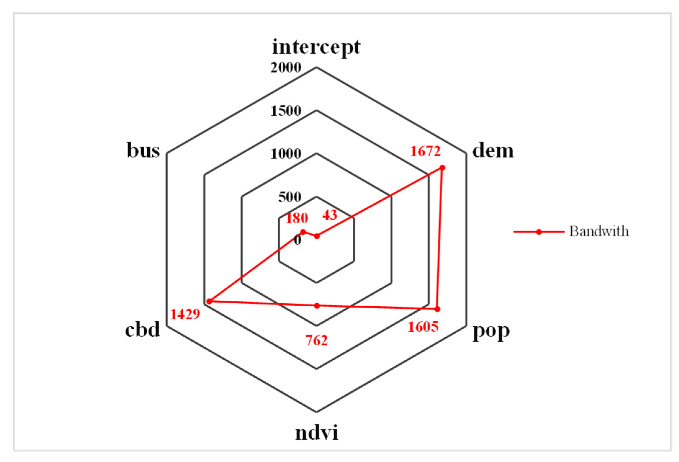
| intercept | 0 | 0 | 0.909563124 ** | 2.625133 | 177 | 0.080246096 | 0.836379 | 43 |
| DEM | −0.074 *** | −4.087 | −0.22335 | 0.2164 | 177 | −0.069925622 | 1.6365 | 1672 |
| pop | −0.041 ** | −2.165 | −1.43368 | 0.71453 | 177 | 0.00741654 | 0.298809 | 1605 |
| NDVI | 0.154 *** | 8.607 | 0.144686 | 0.977292 | 177 | 0.075891598 ** | 2.131271 | 762 |
| CBD | 0.337 *** | 16.853 | 0.792347 | 1.289819 | 177 | 1.22245201 *** | 4.139189 | 1429 |
| bus | −0.17 *** | −9.763 | −0.680588228 ** | 2.02741 | 177 | −0.169607141 ** | 2.32578 | 180 |
| bs | 2667 | 2667 | 2667 | |||||
| AICc | 6971.06 | 6186.975 | 5998.129 | |||||
| R^2 | 0.2049 | 0.488 | 0.539 | |||||
| Adj.R^2 | 0.2034 | 0.449 | 0.497 | |||||
Publisher’s Note: MDPI stays neutral with regard to jurisdictional claims in published maps and institutional affiliations. |
© 2022 by the authors. Licensee MDPI, Basel, Switzerland. This article is an open access article distributed under the terms and conditions of the Creative Commons Attribution (CC BY) license (https://creativecommons.org/licenses/by/4.0/).
Share and Cite
Yue, L.; Zhao, H.; Xu, X.; Gu, T.; Jia, Z. Quantifying the Spatial Fragmentation Pattern and Its Influencing Factors of Urban Land Use: A Case Study of Pingdingshan City, China. Land 2022, 11, 686. https://doi.org/10.3390/land11050686
Yue L, Zhao H, Xu X, Gu T, Jia Z. Quantifying the Spatial Fragmentation Pattern and Its Influencing Factors of Urban Land Use: A Case Study of Pingdingshan City, China. Land. 2022; 11(5):686. https://doi.org/10.3390/land11050686
Chicago/Turabian StyleYue, Li, Hongbo Zhao, Xiaoman Xu, Tianshun Gu, and Zeting Jia. 2022. "Quantifying the Spatial Fragmentation Pattern and Its Influencing Factors of Urban Land Use: A Case Study of Pingdingshan City, China" Land 11, no. 5: 686. https://doi.org/10.3390/land11050686