Article

Sites of Geological Interest Assessment for Geoeducation Strategies, ESPOL University Campus, Guayaquil, Ecuador

by
Fernando Morante-Carballo
1,2,3,
Bethy Merchán-Sanmartín
1,3,4,
Allen Cárdenas-Cruz
1,4,
Maria Jaya-Montalvo
1,4,*,
Josep Mata-Perelló
5,
Gricelda Herrera-Franco
3,6 and
Paúl Carrión-Mero
1,4
1
Centro de Investigación y Proyectos Aplicados a las Ciencias de la Tierra (CIPAT), Campus Gustavo Galindo, ESPOL Polytechnic University, Km. 30.5 Vía Perimetral, Guayaquil P.O. Box 09-01-5863, Ecuador
2
Facultad de Ciencias Naturales y Matemáticas (FCNM), Campus Gustavo Galindo, ESPOL Polytechnic University, Km. 30.5 Vía Perimetral, Guayaquil P.O. Box 09-01-5863, Ecuador
3
Geo-Recursos y Aplicaciones GIGA, Campus Gustavo Galindo, ESPOL Polytechnic University, Km. 30.5 Vía Perimetral, Guayaquil P.O. Box 09-01-5863, Ecuador
4
Facultad de Ingeniería Ciencias de la Tierra (FICT), Campus Gustavo Galindo, ESPOL Polytechnic University, Km 30.5 Vía Perimetral, Guayaquil P.O. Box 09-01-5863, Ecuador
5
Departamento de Ingeniería Minera y Recursos Naturales, Universidad Politécnica de Cataluña, 08242 Manresa, Spain
6
Facultad de Ciencias de la Ingeniería, Universidad Estatal Península de Santa Elena (UPSE), Avda. Principal La Libertad–Santa Elena, La Libertad 240204, Ecuador
*
Author to whom correspondence should be addressed.
Land 2022, 11(6), 771; https://doi.org/10.3390/land11060771
Submission received: 5 May 2022 / Revised: 22 May 2022 / Accepted: 23 May 2022 / Published: 24 May 2022

Abstract

:
The development of geoeducation generates a link between people, landscapes, and their culture by recognising the geological potential around geosites and their conservation. Geosites have important scientific value and constitute a way of generating learning tools for the development of geoeducation. The city of Guayaquil, the main port of Ecuador, has a valuable geological and mining heritage, which has been affected by population growth and its invasion of protected areas, causing the displacement of animal species to the point of possible extinction. The research aims to assess geosites in the surroundings of the Gustavo Galindo campus, using the Spanish Inventory of Sites of Geological Interest (IELIG, Spanish acronym) methodology to promote geo-education in the context of sustainability. The methodological process includes (i) the inventory and initial selection of Sites of Geological Interest (SGI) based on interviews with experts and the analysis of primary data from potential sites; (ii) characterisation and semi-quantitative geosites assessment using the IELIG methodology; and (iii) qualitative assessment through SWOT analysis to formulate geotourism and geoeducation development strategies. This research emphasises the importance of promoting geological heritage in an urban area. It shows geotourism attractions represented by five SGI grouped into two types: geomorphological and petrological. In general, the SGI are in the “High” category of the degree of geological interest, ranging from 170 to 236.67. In addition, the study identified the lack of a geological culture and natural values of the university campus. It allowed the proposal of protection strategies (e.g., a geoconservation plan ensuring that the number of visitors does not exceed the maximum load capacity), geoscientific dissemination (e.g., creating games, museums, itineraries, launching geoeducational souvenirs, or developing educational content using augmented reality) and a detailed research based on evaluating sites for sustainable development.

1. Introduction

The term “geopark” began to be used in 2000 with the opening of four European countries (France, Germany, Greece, and Spain) to sustain development under the protection and enhancement of geological heritage. This initiative was recognised internationally in November 2015 by the United Nations Educational, Scientific, and Cultural Organization (UNESCO) with the creation of the International Geoscience and Geoparks program [1]. Currently, this network has 169 recognised geoparks in 44 countries [2]. Through the Global Geoparks Network, UNESCO promotes the conservation of geological heritage (known as geoconservation) and the sustainable development of the communities influenced by the geopark [3,4].
The birth of geotourism in 1990 and the evolution of geoparks allow the development of awareness of geological heritage, scientific heritage, and cultural values. These concepts establish links that make people reconnect through experiences and emotions [5]. Despite these initiatives to promote and protect the geoheritage, there is a reasonable need to promote geoeducation [6].
Geoparks, through geotourism and sustainable development, offer a means to integrate the natural and cultural components of the landscape sustainably, promoting the conservation and protection of geosites [7,8]. In addition, geotourism promotes various forms of geoeducation so that geological sites are open to the public and offer educational and recreational activities [9]. While geoeducation is commonly based in the classroom or laboratory, geoeducation in the field setting is focused on existing outcrops, landscapes, and processes. Therefore, these sites can use primary, secondary, and tertiary educational institutions and other groups interested in geosciences [10].
Geoeducation is a form of education focused on geosciences [11,12]. According to Brocx and Semeniuk [10], geoeducation is a process to facilitate learning or the acquisition of knowledge about geology through the use of the geological site. However, there are geosites, according to their characteristics, that are suitable for geoeducational purposes (didactic potential) or tourism (aesthetic value) [12,13].
Many geosites are vulnerable to various anthropogenic and natural threats, making it necessary to conserve geological heritage [14]. Geoheritage allows the identification and preservation of specific elements of geodiversity [5,15], which is threatened by the excessive growth of vegetation and urban development [16].
The Spanish Inventory of Sites of Geological Interest (whose acronym in Spanish is IELIG) [17] is one of the most used methodologies in the characterisation and identification of geosites, based on the conservation of biodiversity and the management of outdoor recreation, developing geoconservation equivalents [5] considering tourist, scientific, and academic criteria. Furthermore, unlike the Brilha [18] and GAM [19] methodologies, IELIG facilitates a diagnosis to design geoconservation measures, establishing protection priority criteria [20].
There is a variety of types of geosites; some can be called “geomorphosites” due to their geomorphological and geological value (e.g., waterfall, canyon, mountain peak, and erratic boulder) [13]. Other geosites focus on the cultural importance of geological heritage and consider geographical accidents or geological characteristics as heritage elements (e.g., mineral deposits, tectonic structures, paleontological deposits, and outcrops of different types of rocks). In contrast, other geosites consider strong links between cultural heritage and geological elements, where these can be historical monuments and archaeological remains [16].
The characterisation of geosites within a city invites the viewer to understand, conserve and use the unique wealth of geodiversity resources available to provide social, economic, and environmental benefits to urban communities and visitors. Furthermore, its characterisation allows geosites to be protected from numerous threats that must be considered in densely populated urban areas, combining the conservation of geological heritage with sustainable development [21,22].
Among the geoparks with an urban-type geoheritage and geoeducation activities, the most notable and recognised is the Hong Kong UNESCO Global Geopark in China [4,23], due to its diverse ecological resources, sedimentary rock formations, and hexagonal columns of acidic volcanic rocks very close to the city [24]. Other examples are the Araripe Geopark (Brazil) [25], the Lesvos Island Global Geopark (Greece) [26], the Gea Norvegica Global Geopark (Norway), and the Luochuan Loess National Geopark on the Chinese Loess Plateau. The latter presents geoheritage as a basis for reserving areas for geoconservation and geotourism [27].
Ecuador is internationally recognised as a megadiverse country of approximately 283,600 km² and is part of the 196 nations that belong to the Convention on Biological Diversity [28]. Furthermore, since 2019, Ecuador has belonged to the UNESCO Global Network of Geoparks, recognising Imbabura [2]. Many of the cities of Ecuador maintain very diverse cultures and geological features, but only some of them are recognised internationally due to tourism development. Likewise, Ecuador has excellent potential for geotourism and geoeducation development, giving rise to opportunities for the local and regional economy [29,30].
Large metropolises need green spaces, which have been lost with population growth and the invasion of protected areas. Causing the displacement of animal species to other habitats increases their vulnerability to survival [31]. The city of Guayaquil, the main port of Ecuador on the western coast of South America, presents urban development problems and has a deficit of green areas [32]. However, it is marked by features of geodiversity, which show an important geological and mining heritage with potential for geotourism development within the city territory [24]. Furthermore, the Gustavo Galindo university campus, located on the outskirts of the city of Guayaquil, in the Escuela Superior Politécnica del Litoral (Polytechnic University), is situated in the “Prosperina” Protective Forest, with tropical-dry characteristics, being an opportunity for the protection of nature, geotourism, and sustainable development emphasising conservation, education, and geotourism attractiveness [33].
Being ESPOL, a leading university in Ecuador, which has environmental recognition, its mission is to promote the sustainable development of the “Prosperina” Protective Forest, located within the Gustavo Galindo Campus, establishing the protection and safeguarding of an area rich in biodiversity [31] and geodiversity. With what strategies can geoeducation and geoconservation activities be developed on a university campus? Therefore, this research aims to evaluate sites of geological interest on the Gustavo Galindo campus of the ESPOL University, using the IELIG methodology to promote geoeducation and geoconservation in a sustainability context.

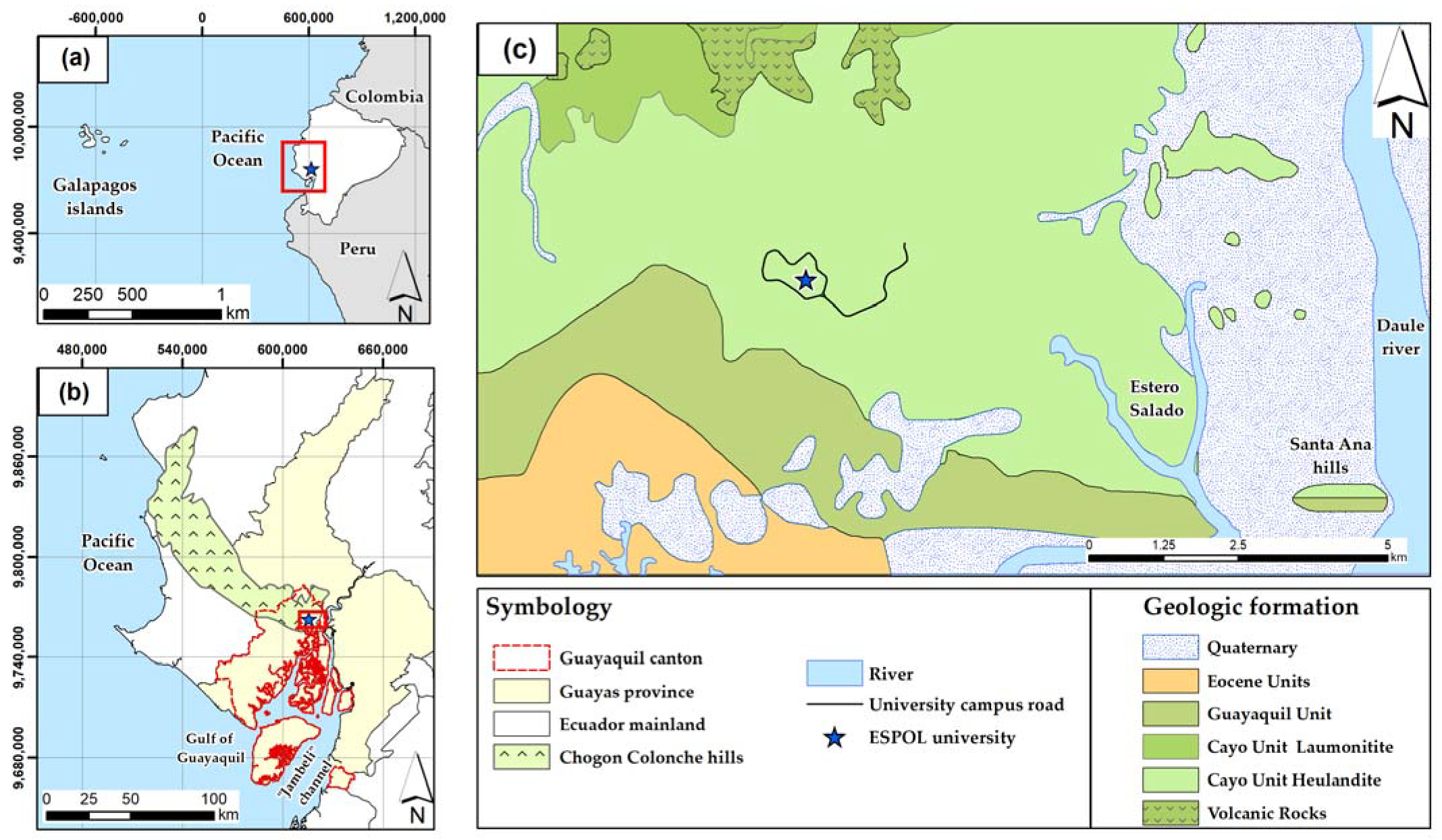
2. Geographical and Geologic Setting

The study area is located southwest of the coastal region of Ecuador. Specifically, it is at the Gustavo Galindo (ESPOL) university campus, in the west of the city of Guayaquil in the province of Guayas (Figure 1). The zone consists of 675.35 hectares, of which 332.30 hectares are considered protective forests [34]. From a geological point of view, the coastal area of Ecuador is formed by accumulated fragments of the Late Cretaceous mafic oceanic basement [35], forming thick volcanoclastic, volcanic, and intrusive rock sequences [36] and turning the city of Guayaquil into part of the orographic development of the Cordillera Chongón–Colonche (C.C.C) [37,38]. The Cordillera Chongón–Colonche groups the Orquídeas, Calentura, Cayo, and Guayaquil formations [39] that overlie the basaltic magmatic basement called the Piñón formation [36].
Features of geological evidence characterise the Campus, the main one being the zeolite deposits developed throughout the coastal extension of the country [40]. The zeolitised rocks of the Campus are in the Cayo formation as part of the sequence of deposition of marine and volcanoclastic sediments [41] that extend over an area of more than 1000 km of surface [40]. The most common zeolite mineral, heulandite, occurs mainly in the central part of the study area (Figure 1c).
The lithology of the Cayo formation includes volcanoclastic rocks, such as tuffaceous shales, greywackes, sandstones, shales, and argillites, which present differences in mineralogy and zeolite content. Locally, the tuffs of this formation are called “green shales” [42]. The Cayo Formation overlies the Piñón Formation (mafic oceanic basement of the coastal area) [35], the Orquídeas Formation (composed of submarine volcanic breccias) [43], and the Calentura Formation (composed of fine-grained flint limestone and thin-bed volcanoclastic turbidites) [44]. In contrast, the Guayaquil formation (consisting of siliceous shales intertwined with cherts) [39,44] overlies it and extends to the south of the study area (Figure 1c).

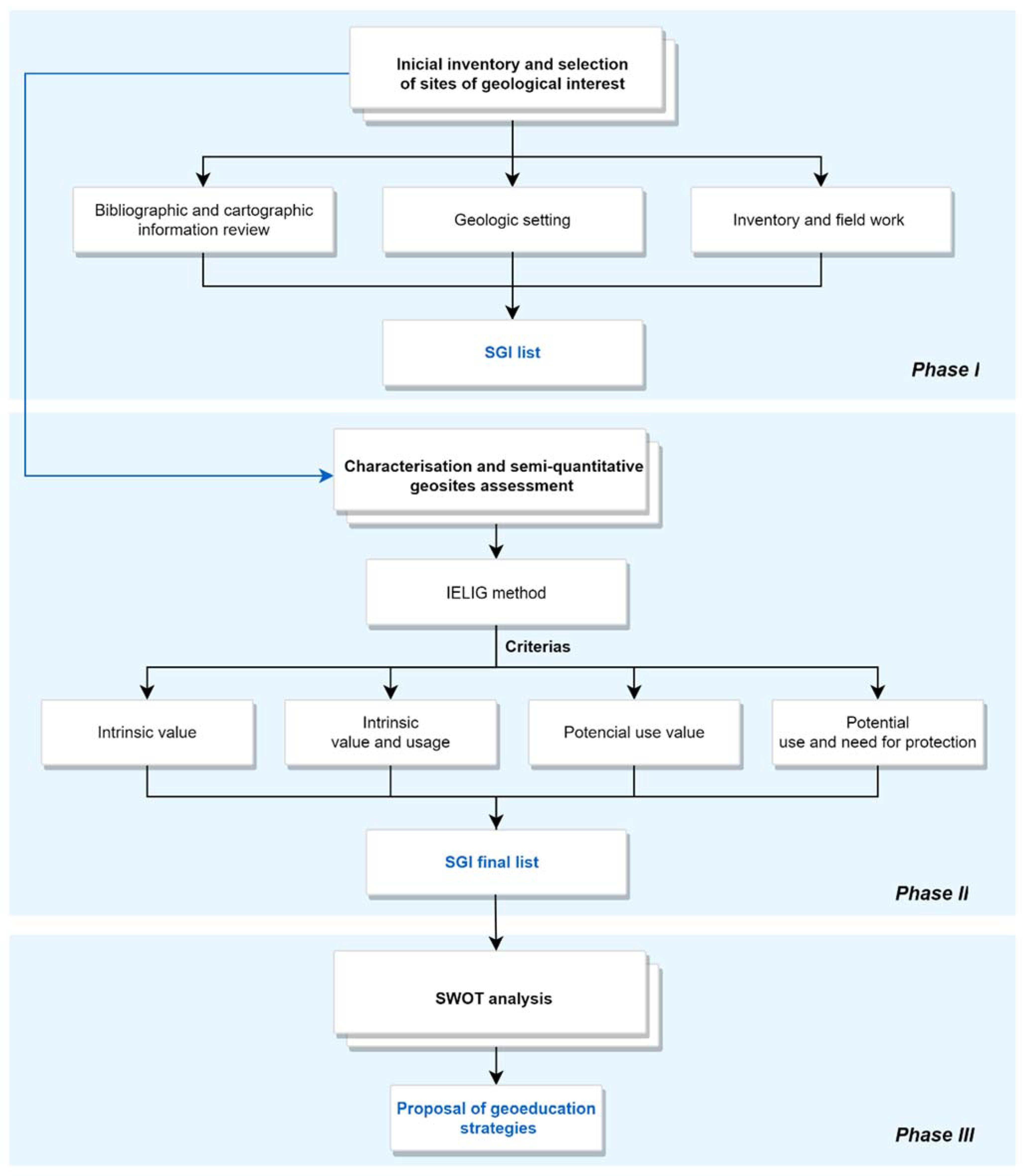
3. Materials and Methods

The methodology applied for the inventory and characterisation of geosites used the semi-quantitative assessment of IELIG proposed by García-Cortés et al. [17]. This method is based on criteria to evaluate the intrinsic value and potential use and estimate the value of the protection priority. Various authors have used the IELIG method in the inventory and catalogue of geosites [45,46]. Therefore, the methodology of this study was structured in three phases (Figure 2): (i) inventory and initial selection of sites of geological interest; (ii) characterisation and semi-quantitative geosites assessment using the IELIG methodology; and (iii) qualitative assessment using SWOT analysis for the formulation of geoeducation development strategies.

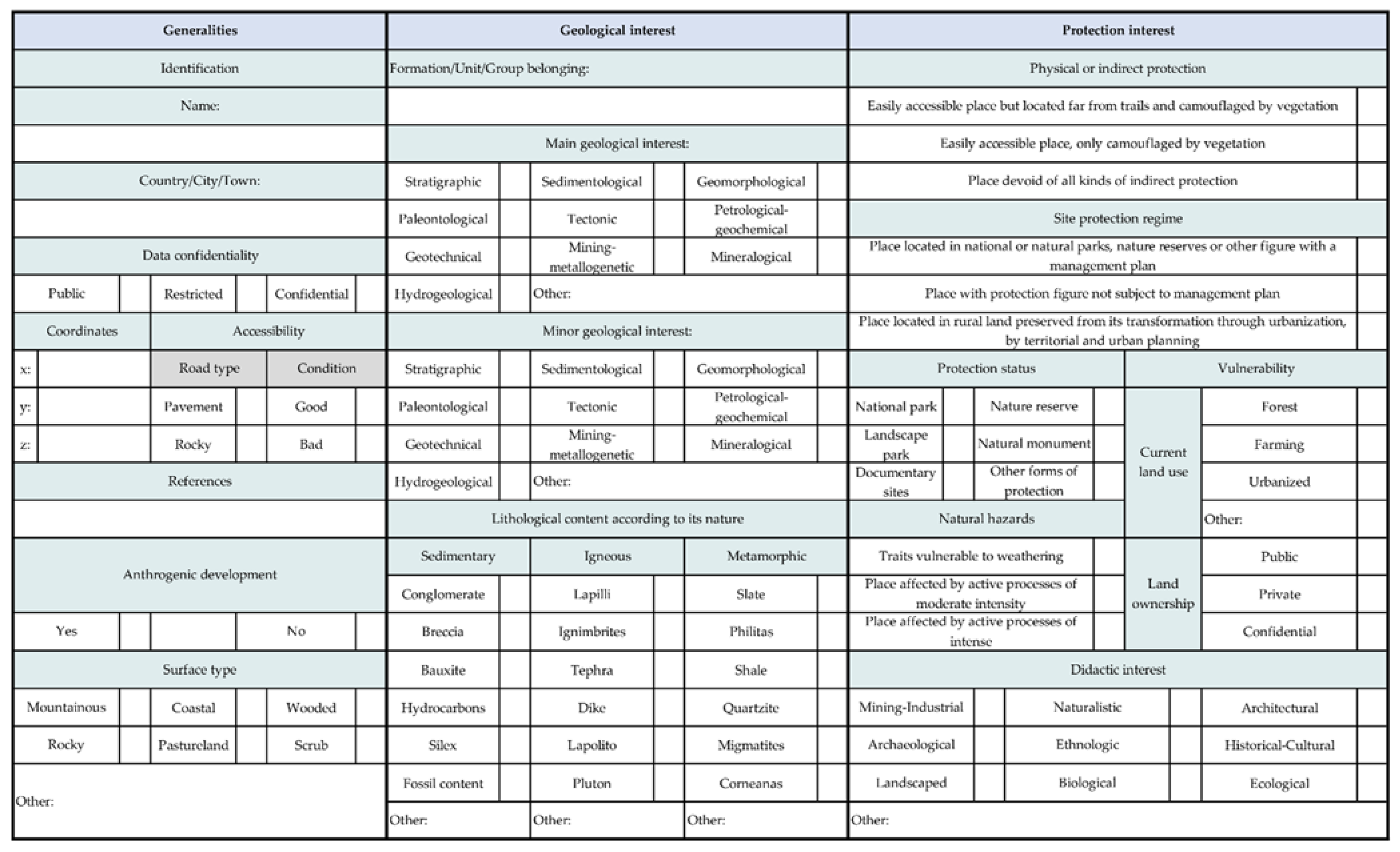
3.1. Phase I: Inventory and Initial Selection of Sites of Geological Interest

In the first phase, basic information was collected on the study area and its surroundings, in particular, available cartographic data on lithologic units, mineral occurrences, the fossil record, soils, and significant geologic structures (e.g., hydrogeologic map [47]). In addition, we also collected doctoral theses and scientific publications that are related to the geological framework of interest. The current tourist trails of the sector and inventories of the biotic and cultural characteristics were reviewed. Interviews were also conducted with four experts who have worked in geology, mineralogy, petrology, stratigraphy and sedimentation, works infrastructure, and ecology of the ESPOL’s Gustavo Galindo Campus and areas of the “Prosperina” Protected Forest.
The interviews were based on a questionnaire to discover the geotourism potential of the ESPOL Campus. The interviews were based on four themes: (i) sites of geological interest on campus, (ii) the relationship SGI have with other elements of the natural and cultural heritage, (iii) environmental and geological studies related to SGI, and (iv) potential for geoeducation on campus and its relationship with proposals for environmental conservation in the city. The interviews emphasised the importance of knowing, protecting, and safeguarding an area of enormous wealth in geo-biodiversity located within the city, addressing the problem from various perspectives (environmental pollution, extension of species, exploitation of resources, and population growth) and making known the benefits of considering the campus as a source of geosites. The study selected five sites of geological interest based on the parameters previously described. Figure 3 shows the general sheet used to identify the sites of geological interest.

3.2. Phase II: Characterisation and Semi-Quantitative Geosites Assessment

In phase II, the semi-quantitative assessment of IELIG (proposed by García-Cortés et al. [17]) was carried out in the five sites of geological interest. The IELIG method is based on four types of criteria: (i) intrinsic, (ii) intrinsic value and usage, (iii) potential use–value, and iv) potential use and need for protection. Table 1 presents the parameters and weights established by the authors García-Cortés et al. [17] for each scientific, didactic, and tourist value. The score for each parameter is assigned on a scale of 0 to 4, excluding a score of 3. The result for the type of value (scientific, didactic, and tourist) results from multiplying the score of each parameter (0 to 4) by its weight. Representativeness is the parameter with the high weight according to the methodology (30% in Table 1). The sum of the three values indicates the level of interest of each geosite (very high, high, medium, and low), and the ranges of the level of interest are shown in Table 2.
After selecting and calculating the values of interest, the aim was to prioritise the protection of each geosite based on the assessment of the susceptibility to degradation (SD). The SD results from the application of Equation 1, and the evaluated parameters of vulnerability by Anthropic Threats (A) and Fragility (F) are detailed in Table 3.
SD = F   ×   A   × 1 400
Subsequently, having obtained the value of degradation susceptibility, the global protection priority (PP) of each evaluated geosite was determined according to the possible values of interest (scientific, didactic, and tourist) based on the mathematical expressions shown in Table 4.

3.3. Phase III: Qualitative Assessment Using SWOT Analysis

In phase III, a SWOT analysis [48] was carried out using a focus group to identify the planning strategies that respond to the main weaknesses and threats detected in the IMS. The strategies result from the combination of the Weaknesses (W) and Strengths (S) with the Threats (T) and Opportunities (O) of the developed matrix. SWOT analysis was used to formulate lines of action in the management and conservation of geological heritage and development of geotourism in various studies [49,50]. Furthermore, this qualitative analysis makes it possible to complement the semi-quantitative evaluation of phase II, particularly of those sites of geological interest that have a low rating in assessing the parameters related to the criteria of potential use and need for protection.

4. Results

4.1. Sites of Geological Interest: Identification, Description, and Semi-Quantitative Assessment

Table 5 shows the five SGI with their characteristics and type of main geological interest. The petrologic and geomorphologic geological interests are highlighted. Additionally, Figure 4 shows images of the five SGI within the university campus evaluated in this study.
Figure 5 shows the location of the five sites of geological interest within the university campus, the two established georoutes, and the tourist and environmental education attractions. Georoute 1 includes SGI 5, 1 and 2. In SGI 5 (Access B), it is possible to observe a metric depositional sequence of the Cayo formation, constituting a point to study the sedimentological and stratigraphic records of the sector. SGI 1 (Access A) is part of the knowledge park lake (PARCON) (“albarradas”) formed by taking advantage of the local geomorphology, which flows through a spillway in an environment surrounded by rhythmically stratified lapilli tuffs. The SGI 2 (Access C) is adjacent to places of ecological interest (e.g., environmental interpretation centres, nurseries, sighting of endemic species, and recycling plants). The route is part of a 1.5 km trail where you can observe the city’s landscape and its geomorphology.
Georoute 2 includes SGI 2, 4, and 3. SGI 3 and SGI 4 (Access D) are part of an ecological trail; in SGI 4, an outcrop of zeolites is observed, and on its side, it is possible to identify a seasonal creek, while in SGI 3, it is possible to watch and take samples from the outcrop of the K/Pg contact, being used as a geoeducational tool for geology students.
Table 6 shows the results of the evaluation of the five SGI. In general, the sites of geological interest are in the “High” category of the degree of geological interest, ranging from 170 to 236.67. SGI 4 stands out as it presents a higher degree of scientific interest due to its maximum valuation in the parameter of scientific knowledge of the place where doctoral theses and scientific publications have been carried out. In addition, the site presents several types of secondary geological interest, such as lithological, volcanic, and sedimentological diversity. On the other hand, SGI 1 shows a low degree of scientific interest because its intrinsic value of representativeness is the parameter that had the lowest value of the five sites evaluated (Figure 6). Additionally, there are similar places, and the vegetation prevents the appreciation of some features of interest.
Regarding the degree of didactic interest, SGI 2 has a high degree of interest because it is a viewpoint where the characteristic geomorphology of the place can be observed. The site is associated with other natural heritage values, which are being used for didactic purposes. While SGI 1 has a low degree of didactic value, mainly due to its ability to illustrate geological characteristics only for university-type educational levels.
From the point of view of tourist value, SGI 2 is the site that presents the highest score in the assessment due to the potential it has for recreational and leisure activities (e.g., cycling and bird watching) and presents the highest value in the parameter of spectacularity and beauty. In contrast, SGI 1 shows a low degree of interest due to the limited capacity to illustrate visitors’ main geological interest and attraction. The vegetation is the primary agent that affects the observation conditions of the site.
On the other hand, Figure 7a shows the results of the evaluation of the degree of susceptibility, highlighting that only SGI 1, which represents 26% of the five sites evaluated, has a protection priority level in the “High” category, indicating that the site is vulnerable due to its easy access. Figure 7b shows the results of the calculation of the global protection priority; likewise, a single site (SGI 5) is within the “High” category, representing 31% of the evaluated value, which indicates the need for urgent or short-term protection measures. In comparison, the remaining SGI 4 with 69% has a “Medium” protection priority level.

4.2. Qualitative Assessment: SWOT Analysis

Table 7 shows the result of the SWOT analysis based in focus group and interview, highlighting that the campus is one of the leading green spots in the city and has environmental education tools on the trails. The main weakness is the campus’s lack of geological cultural and natural values. Some strategies focus on the promotion of geotourism and in situ geoeducation can be established considering the SWOT analysis:
  • Guarantee that the number of visitors does not exceed the maximum load capacity of the sites of geological interest and the elements of native or endemic biodiversity of the campus.
  • Promote the quintuple helix model of innovation [51] on campus by strengthening the circular economy system in all the axes of its management, integrating the value of geological heritage.
  • Articulate nature interpretation programs with geological heritage values by creating games or augmented reality that highlights the main geological interest of the sites.
  • Include geoeducation as part of the campus environmental training program.
  • Launch geoeducational souvenirs at specific points of the campus routes to awaken their interest in exploring the sites and raising awareness about the importance of geoscience.
  • Implementation of a geo-mining museum and itineraries within the campus as part of the earth sciences education program.

5. Interpretation of the Results and Discussion

The university campus constitutes a natural laboratory that houses sites of main geological interest of petrological and geomorphological types (Figure 5). The campus has initiatives for environmental education and awareness. However, its geological heritage has not been investigated and directly articulated to the axes of geo-environmental management. The result of the evaluation of the present study revealed that the sites of geological interest are in the “High” category of type of geological interest (Figure 5 and Figure 6) according to the classification of the IELIG methodology proposed by García-Cortés et al. [17] and many of the sites have associations with other types of values (e.g., ecological and landscape).
Regarding the evaluation according to scientific value, SGI 4 (Figure 6) stands out as being the one with the “highest” score due to its state of conservation and the diversity of geological elements associated with the site, added to the high degree of scientific knowledge developed in research registered in doctoral theses and publications in international scientific journals. However, the existence of scientific publications on a certain geosite does not necessarily represent a high scientific value [18]. In this case, SGI 3 has a value of zero in the indicator of the degree of scientific knowledge of the place and remains within the “High” category of geological interest rate. On the other hand, SGI 1 (Figure 6) has the lowest score in this parameter, mainly due to its low level of representativeness, which is the parameter that has the most weight in the assessment (30%) (Table 1). This is In addition to its observation conditions (the vegetation problem) that prevent the appreciation of some characteristics of interest and its low score in the rarity parameter because several sites have similar petrological content in the environment.
According to the didactic value, SGI 2 (Figure 6) is at the top of the score due to its vast openness to carry out didactic activities at any level of the educational system (e.g., schools, universities, academies, and tourist agencies). Additionally, there are organised educational activities commonly held in the nature reserve. Meanwhile, SGI 1 (Figure 6) presents a pedagogical scenario for studies at a single academic level (university). It is possible to appreciate civil engineering works that allow sustainable water development within the university. However, the general assessment of the five places shows a high didactic potential for the development of geoeducation.
Regarding the evaluation according to the tourist value, the SGI 2 (Figure 6) stands out for obtaining the “highest” score due to the important place of the nature reserve in the city, the conservation and care of flora and fauna are promoted, avoiding deterioration of human activities. Additionally, it is not only a point of observation of elements of natural value. It also allows identifying the geomorphology of the sector, which makes it attractive for tourists. On the contrary, SGI 1 (Figure 6) presents the “lowest” score among the five sites evaluated since its potential for informative content of geological interest is low, and it is a site little known by the university community, despite being a landscaped place that presents a chromatic variety of the artificial lake of ESPOL.
From the point of view of degradation susceptibility, SGI 1 (Figure 7a) is in the “High” category, due to its free public access (next to a secondary road). In addition, its limited size makes it susceptible to deterioration by human activities. A not very distant case occurs with SGI 3 and SGI 4 (Figure 7a). Both have the category “Medium”. These sites are part of the trail where the pipeline system crosses laterally and have lithologies that can be affected by active processes (e.g., erosion). While the results of global protection priority indicate that SGI 5 (Figure 7b) is in the “High” category because it is close to a main paved road with free access, SGI 3 (Figure 7b) has a lower value within the “Medium” category, as it is a little-explored place and has indirect protection by vegetation.
Regarding the qualitative evaluation through the SWOT analysis (Table 7), one of the main weaknesses is the lack of a culturalisation of the geological and natural values of the campus. However, the university has a study plan for geology engineering and environmental education. Therefore, the university must establish “geoconservation” in the education domains. This culturalisation of geological values begins at the campus facilities, allocating areas for geoeducation, such as installing a museum on campus or creating itineraries, where basic concepts of geology, geological heritage, and association of geology with other areas of study. This space highlights the campus’s geological heritage and its surroundings at a regional level.
Examples of museums in Ecuador are the Megaterio Paleontological Museum, part of the Universidad Estatal Península de Santa Elena (UPSE) campus that presents specimens corresponding to the Upper Pleistocene Megafauna [52]. In addition, the Museum of Geology and Mineralogy of the Escuela Politécnica Nacional (EPN) [53] has ex situ elements of the country’s geological heritage. At an international level, some university examples that made geoeducational activities are the fossil collection of the Natural Science Museum of the University of Zaragoza (Spain) [54], the Vanished World Fossil Center and the Vanished World Trail promoted by the Geology Department of Otago University (New Zealand) [53], and the Mineralogical School of Mineral Science and Technology Museum in Ouro Preto (Brazil) shows part of the mining geoheritage of the sector [55].
Undoubtedly, the concepts of geological heritage and geoconservation are not exclusive to geopark initiatives [4,56,57], but instead offer the possibility of including them within the educational programs of universities, such as the University of Minho (Portugal) [58], which incorporate these concepts by creating careers dedicated to these domains in undergraduate and postgraduate studies.
In general, the internationalisation of the themes of geological heritage and geoconservation opens the possibility of generating jobs for young people within geoparks, protected areas, museums, and other areas dedicated to this theme [58,59]. Therefore, it becomes a challenge to promote geoheritage values and their benefits at all levels of education.

6. Conclusions

The study allowed the semi-quantitative assessment of sites of geological interest on a university campus and within the city that are subject to pressures from urban development and the limitation of green areas. The research revealed the abundant possibilities of integrating natural values and organised educational activities with geological values in situ. Additionally, the assessment results allowed the identification of weaknesses and the establishment of improvement strategies. Mainly, many of the SGI are camouflaged by the presence of vegetation, which diminishes their aesthetic value.
Furthermore, there is a lack scientific knowledge of the SGI and are close to main paved roads, which increases their vulnerability to looting.
In particular, strategies aimed at geoeducation in a context of sustainability were established, such as:
  • Develop a geoconservation plan, ensuring that the number of visitors does not exceed the maximum load capacity of the sites of geological interest and the biodiversity elements of the campus.
  • Integrate the value of the geological heritage in the quintuple helix model of campus innovation by strengthening a circular economy system in all the axes of its management.
  • Articulate existing ecological interpretation programs with geological heritage values by creating games, museums, itineraries, launching geoeducational souvenirs, or developing educational content using augmented reality that highlights the sites’ main geological interest and surroundings.
  • Include geoeducation as part of the campus environmental training program.
Additionally, the proposed georoutes will strengthen the existing biodiversity routes in the campus sustainability plan, and new geotourism routes may be proposed that would be the sum of geosites, biosites, and artificial structures, such as large “albarradas” or dams, which serve to regulate the creeks in invasion zones on the perimeter of the university.
Geoeducation becomes a challenge for universities. The need arises to link geoconservation and the values of geological heritage in situ and ex situ with the sustainability projects promoted in higher education in the 21st century.

Author Contributions

Conceptualisation, F.M.-C., B.M.-S., M.J.-M., J.M.-P., G.H.-F. and P.C.-M.; methodology, F.M.-C., B.M.-S., M.J.-M., J.M.-P., G.H.-F. and P.C.-M.; investigation, F.M.-C., B.M.-S., M.J.-M., J.M.-P., G.H.-F. and P.C.-M.; writing—original draft preparation, F.M.-C., B.M.-S., A.C.-C., M.J.-M., J.M.-P., G.H.-F. and P.C.-M.; writing—review and editing, F.M.-C., B.M.-S., A.C.-C., M.J.-M., J.M.-P., G.H.-F. and P.C.-M.; supervision, F.M.-C. and P.C.-M. All authors have read and agreed to the published version of the manuscript.

Funding

This research was supported by the ‘Registry of geological and mining heritage and its impact on the defence and preservation of geodiversity in Ecuador’ research project by ESPOL University (CIPAT-01-2018).

Institutional Review Board Statement

Not applicable.

Informed Consent Statement

Not applicable.

Data Availability Statement

Not applicable.

Acknowledgments

The authors would like to acknowledge the international project entitled ‘Ibero-American mineral routes and territorial planning: an integral factor for the sustainable development of society’ (the acronym in Spanish is RUMYS).

Conflicts of Interest

The authors declare no conflict of interest.

References

  1. Reynard, E.; Brilha, J. Geoheritage: A Multidisciplinary and Applied Research Topic. In Geoheritage Assessment, Protection, and Management; Reynard, E., Brilha, J., Eds.; Elsevier: Amsterdam, The Netherlands, 2018; pp. 3–9. [Google Scholar]
  2. United Nations Educational, Scientific and Cultural Organization (UNESCO) List of Geoparks & Regional Networks. Available online: https://en.unesco.org/global-geoparks/list (accessed on 6 November 2021).
  3. Gray, M. Geodiversity. In Geoheritage; Elsevier: Amsterdam, The Netherlands, 2018; pp. 13–25. [Google Scholar]
  4. Catana, M.M.; Brilha, J.B. The Role of UNESCO Global Geoparks in Promoting Geosciences Education for Sustainability. Geoheritage 2020, 12, 1. [Google Scholar] [CrossRef]
  5. Gordon, J.E.; Crofts, R.; Díaz-Martínez, E. Geoheritage Conservation and Environmental Policies. In Geoheritage; Elsevier: Amsterdam, The Netherlands, 2018. [Google Scholar]
  6. Zafeiropoulos, G.; Drinia, H.; Antonarakou, A.; Zouros, N. From Geoheritage to Geoeducation, Geoethics and Geotourism: A Critical Evaluation of the Greek Region. Geosciences 2021, 11, 381. [Google Scholar] [CrossRef]
  7. Brilha, J. Geoheritage: Inventories and Evaluation. In Geoheritage Assessment, Protection, and Management; Reynard, E., Brilha, J., Eds.; Elsevier: Amsterdam, The Netherlands, 2018; pp. 69–85. [Google Scholar]
  8. Herrera-Franco, G.; Montalván-Burbano, N.; Carrión-Mero, P.; Apolo-Masache, B.; Jaya-Montalvo, M. Research Trends in Geotourism: A Bibliometric Analysis Using the Scopus Database. Geosciences 2020, 10, 379. [Google Scholar] [CrossRef]
  9. Hose, T.A. 3G’s for Modern Geotourism. Geoheritage 2012, 4, 7–24. [Google Scholar] [CrossRef]
  10. Brocx, M.; Semeniuk, V. The ‘8Gs’—A Blueprint for Geoheritage, Geoconservation, Geo-Education and Geotourism. Aust. J. Earth Sci. 2019, 66, 803–821. [Google Scholar] [CrossRef]
  11. Sellier, D. La Vulgarisation Du Patrimoine Géomorphologique: Objets, Moyens et Perspectives. Bull. L’Association Geogr. Fr. 2009, 86, 67–81. [Google Scholar] [CrossRef]
  12. Arrad, T.Y.; Errami, E.; Ennih, N.; Ouajhain, B.; Ettachfini, E.M.; Bouaouda, M.S. From Geoheritage Inventory to Geoeducation and Geotourism Implications: Insight from Jbel Amsittene (Essaouira Province, Morocco). J. Afr. Earth Sci. 2020, 161, 103656. [Google Scholar] [CrossRef]
  13. Coratza, P.; Hobléa, F. The Specificities of Geomorphological Heritage. In Geoheritage; Elsevier: Amsterdam, The Netherlands, 2018. [Google Scholar]
  14. Prosser, C.D.; Díaz-Martínez, E.; Larwood, J.G. The Conservation of Geosites. In Geoheritage; Elsevier: Amsterdam, The Netherlands, 2018. [Google Scholar]
  15. Carrión-Mero, P.; Montalván-Burbano, N.; Herrera-Narváez, G.; Morante-Carballo, F. Geodiversity and Mining towards the Development of Geotourism: A Global Perspective. Int. J. Des. Nat. Ecodyn. 2021, 16, 191–201. [Google Scholar] [CrossRef]
  16. Reynard, E.; Giusti, C. The Landscape and the Cultural Value of Geoheritage. In Geoheritage; Elsevier: Amsterdam, The Netherlands, 2018. [Google Scholar]
  17. García-Cortés, Á.; Carcavilla Urquí, L.; Apoita Mugarza, B.; Arribas, A.; Bellido, F.; Barrón, E.; Delvene, G.; Díaz-Martínez, E.; Díez, A.; Durán, J.J.; et al. Documento Metodológico Para La Elaboración del Inventario Español de Lugares de Interés Geológico (IELIG). Propuesta Para La Actualización Metodológica; Instituto Geológico y Minero de España: Madrid, Spain, 2013; pp. 1–64. [Google Scholar]
  18. Brilha, J. Inventory and Quantitative Assessment of Geosites and Geodiversity Sites: A Review. Geoheritage 2016, 8, 119–134. [Google Scholar] [CrossRef] [Green Version]
  19. Vujičić, M.D.; Vasiljević, D.A.; Marković, S.B.; Hose, T.A.; Lukić, T.; Hadžić, O.; Janićević, S. Preliminary Geosite Assessment Model (GAM) and Its Application on Fruška Gora Mountain, Potential Geotourism Destination of Serbia. Acta Geogr. Slov. 2011, 51, 361–376. [Google Scholar] [CrossRef]
  20. Bruschi, V.M.; Coratza, P. Geoheritage and Environmental Impact Assessment (EIA). In Geoheritage; Elsevier: Amsterdam, The Netherlands, 2018. [Google Scholar]
  21. Dunlop, L.; Larwood, J.G.; Burek, C.V. Geodiversity Action Plans—A Method to Facilitate, Structure, Inform and Record Action for Geodiversity. In Geoheritage; Elsevier: Amsterdam, The Netherlands, 2018. [Google Scholar]
  22. Franco, G.H.; Mero, P.C.; Carballo, F.M.; Narváez, G.H.; Bitar, J.B.; Torrens, R.B. Strategies for the Development of the Value of the Mining-Industrial Heritage of the Zaruma-Portovelo, Ecuador, in the Context of a Geopark Project. Int. J. Energy Prod. Manag. 2020, 5, 48–59. [Google Scholar] [CrossRef]
  23. Newsome, D.; Dowling, R. Geoheritage and Geotourism. In Geoheritage; Elsevier: Amsterdam, The Netherlands, 2018. [Google Scholar]
  24. Carrión-Mero, P.; Morante-Carballo, F.; Apolo-Masache, B. Evaluation of Geosites as an Alternative for Geotouristic Development in Guayaquil, Ecuador. WIT Trans. Ecol. Environ. 2020, 241, 45–56. [Google Scholar] [CrossRef]
  25. Henriques, M.H.; Castro, A.R.S.F.; Félix, Y.R.; Carvalho, I.S. Promoting Sustainability in a Low Density Territory through Geoheritage: Casa Da Pedra Case-Study (Araripe Geopark, NE Brazil). Resour. Policy 2020, 67, 101684. [Google Scholar] [CrossRef]
  26. Wang, J.; Zouros, N. Educational Activities in Fangshan UNESCO Global Geopark and Lesvos Island UNESCO Global Geopark. Geoheritage 2021, 13, 51. [Google Scholar] [CrossRef]
  27. Dong, H.; Song, Y.; Chen, T.; Zhao, J.; Yu, L. Geoconservation and Geotourism in Luochuan Loess National Geopark, China. Quat. Int. 2014, 334–335, 40–51. [Google Scholar] [CrossRef]
  28. INABIO Ecuador, País Inmenso en Biodiversidad—Biodiversidad—Instituto Nacional de Biodiversidad. Available online: http://www.biodiversidad.gob.ec/ecuador-pais-inmenso-en-biodiversidad/ (accessed on 7 November 2021).
  29. Berrezueta, E.; Sánchez-Cortez, J.L.; Aguilar-Aguilar, M. Inventory and Characterization of Geosites in Ecuador: A Review. Geoheritage 2021, 13, 93. [Google Scholar] [CrossRef]
  30. Carrión-Mero, P.; Morante-Carballo, F. The Context of Ecuador’s World Heritage, for Sustainable Development Strategies. Int. J. Des. Nat. Ecodyn. 2020, 15, 39–46. [Google Scholar] [CrossRef]
  31. Preprint, E.; Ching-Ávalos, S.; Guzmán-Garaicoa, I.; Velástegui-Montoya, A.; Chang-Silva, R.; Herrera-Matamoros, V. Use of Geographic Information Systems for Mapping a Cartographic Baseline of Trails in Gustavo Galindo Campus. In Proceedings of the 18th LACCEI International Multi-Conference for Engineering, Education, and Technology, Buenos Aires, Argentin, 29–31 July 2020. [Google Scholar]
  32. Peek, O.; Hordijk, M.; D’Auria, V. User-Based Design for Inclusive Urban Transformation: Learning from ‘Informal’ and ‘Formal’ Dwelling Practices in Guayaquil, Ecuador. Int. J. Hous. Policy 2018, 18, 204–232. [Google Scholar] [CrossRef]
  33. Martínez, O.R. Patrimonio Geológico. Identificación, Valoración y Gestión de Sitios de Interés Geológico. Geograficando 2008, 4, 233–250. [Google Scholar]
  34. ESPOL Bosque Protector La Prosperina-Bosque. Available online: http://www.bosqueprotector.espol.edu.ec/ (accessed on 3 April 2022).
  35. Luzieux, L.D.A.; Heller, F.; Spikings, R.; Vallejo, C.F.; Winkler, W. Origin and Cretaceous Tectonic History of the Coastal Ecuadorian Forearc between 1° N and 3° S: Paleomagnetic, Radiometric and Fossil Evidence. Earth Planet. Sci. Lett. 2006, 249, 400–414. [Google Scholar] [CrossRef]
  36. Benitez, S. Evolution Geodynamique de La Province Cotiere Sud-Equatorienne au Creace Superieur-Tertiare; Geologie Alpine: Grenoble, France, 1995. [Google Scholar]
  37. Sinclair, J.H.; Berkey, C.P. Geology of Guayaquil, Ecuador, South America. Am. J. Sci. 1924, s5–s7, 491–497. [Google Scholar] [CrossRef]
  38. Alemán, A.M.; Palencia, A.A.; Lezama, E.E.; Montenegro, G. The Chongón/Colonche Orocline Transrotational Bending and the Coeval Opening of the Progreso Basin in Southwestern Ecuador. J. S. Am. Earth Sci. 2021, 111, 103480. [Google Scholar] [CrossRef]
  39. Machiels, L.; Garcés, D.; Snellings, R.; Vilema, W.; Morante, F.; Paredes, C.; Elsen, J. Zeolite Occurrence and Genesis in the Late-Cretaceous Cayo Arc of Coastal Ecuador: Evidence for Zeolite Formation in Cooling Marine Pyroclastic Flow Deposits. Appl. Clay Sci. 2014, 87, 108–119. [Google Scholar] [CrossRef]
  40. Machiels, L.; Snellings, R.; Morante, F.; Elsen, J.; Paredes, C. Mineralogía Cuantitativa de Los Depósitos de Zeolitas En La Costa Del Ecuador. Rev. Tecnológica ESPOL 2006, 19, 41–48. [Google Scholar]
  41. Morante, F. Las Zeolitas de La Costa de Ecuador (Guayaquil): Geologia, Caracterizacion y Aplicaciones; Escuela Superior Politecnica del Litoral: Guayaquil, Ecuador, 2004. [Google Scholar]
  42. Machiels, L.; Morante, F.; Snellings, R.; Calvo, B.; Canoira, L.; Paredes, C.; Elsen, J. Zeolite Mineralogy of the Cayo Formation in Guayaquil, Ecuador. Appl. Clay Sci. 2008, 42, 180–188. [Google Scholar] [CrossRef] [Green Version]
  43. Van Melle, J.; Vilema, W.; Faure-Brac, B.; Ordoñez, M.; Lapierre, H.; Jimenez, N.; Jaillard, E.; Garcia, M. Pre-Collision Evolution of the Piñón Oceanic Terrane of SW Ecuador: Stratigraphy and Geochemistry of the “Calentura Formation”. Bull. Soc. Geol. Fr. 2008, 179, 433–443. [Google Scholar] [CrossRef]
  44. Ordóñez, M.; Jiménez, N.; Suárez, J. “Micropaleontología Ecuatoriana”: Datos Bioestratigráficos y Paleoecológicos de Las Cuencas: Graben de Jambelí. Progreso. Manabí, Esmeraldas y Oriente; Del Levantamiento de La Península de Santa Elena, y de Las Cordilleras Colonche, Costera y Occidental; Petroecuador: Quito, Ecuador, 2006. [Google Scholar]
  45. Corbí, H.; Fierro, I.; Aberasturi, A.; Sánchez Ferris, E.J. Potential Use of a Significant Scientific Geosite: The Messinian Coral Reef of Santa Pola (SE Spain). Geoheritage 2018, 10, 427–441. [Google Scholar] [CrossRef]
  46. Martínez-Graña, A.M.; Legoinha, P.; González-Delgado, J.A.; Dabrio, C.J.; Pais, J.; Goy, J.L.; Zazo, C.; Civis, J.; Armenteros, I.; Alonso-Gavilan, G.; et al. Augmented Reality in a Hiking Tour of the Miocene Geoheritage of the Central Algarve Cliffs (Portugal). Geoheritage 2017, 9, 121–131. [Google Scholar] [CrossRef]
  47. MAGAP Hidrogeológico. Escala 1:100.000. Available online: https://sni.gob.ec/coberturas (accessed on 5 March 2022).
  48. Dyson, R.G. Strategic Development and SWOT Analysis at the University of Warwick. Eur. J. Oper. Res. 2004, 152, 631–640. [Google Scholar] [CrossRef]
  49. Sumanapala, D.; Kubalíková, L.; Wolf, I.D. Assessing Geosites for Geotourism Development: Case Studies from the Southern Part of Sri Lanka. Geoheritage 2021, 13, 85. [Google Scholar] [CrossRef]
  50. Bhosale, S.; Chaskar, K.; Pandey, D.K.; Lakhote, A.; Thakkar, A.; Chauhan, G.; Bhandari, S.; Thakkar, M.G. Jurassic Geodiversity and Geomorphosite of Kanthkot Area, Wagad, Kachchh, Western India. Int. J. Geoherit. Park. 2021, 9, 51–68. [Google Scholar] [CrossRef]
  51. Carayannis, E.G.; Barth, T.D.; Campbell, D.F. The Quintuple Helix Innovation Model: Global Warming as a Challenge and Driver for Innovation. J. Innov. Entrep. 2012, 1, 2. [Google Scholar] [CrossRef] [Green Version]
  52. Herrera-Franco, G.; Erazo, K.; Mora-Frank, C.; Carrión-Mero, P.; Berrezueta, E. Evaluation of a Paleontological Museum as Geosite and Base for Geotourism. A Case Study. Heritage 2021, 4, 1208–1227. [Google Scholar] [CrossRef]
  53. EPN Museo de Geología y Mineralogía. Available online: https://www.epn.edu.ec/museo-de-geologia-y-mineralogia-2/ (accessed on 28 April 2022).
  54. Canudo, J.I. The Collection of Type Fossils of the Natural Science Museum of the University of Zaragoza (Spain). Geoheritage 2018, 10, 385–392. [Google Scholar] [CrossRef] [Green Version]
  55. Mata-Perelló, J.; Carrión, P.; Molina, J.; Villas-Boas, R. Geomining Heritage as a Tool to Promote the Social Development of Rural Communities. In Geoheritage; Elsevier: Amsterdam, The Netherlands, 2018. [Google Scholar]
  56. Szadkowska, K.; Szadkowski, M.; Tarka, R. Inventory and Assessment of the Geoheritage of the Sudetic Foreland Geopark (South-Western Poland). Geoheritage 2022, 14, 24. [Google Scholar] [CrossRef]
  57. Herrera-Franco, G.; Montalván-Burbano, N.; Carrión-Mero, P.; Jaya-Montalvo, M.; Gurumendi-Noriega, M. Worldwide Research on Geoparks through Bibliometric Analysis. Sustainability 2021, 13, 1175. [Google Scholar] [CrossRef]
  58. Brilha, J.; Pereira, D.; Pereira, P. Geoconservation Education: The Leading Role of the University of Minho (Portugal). In Proceedings of the EGU General Assembly Conference Abstracts, Vienna, Austria, 22–27 April 2012; p. 11881. [Google Scholar]
  59. Brilha, J.; Reynard, E. Geoheritage and Geoconservation: The Challenges. In Geoheritage; Reynard, E., Brilha, J., Eds.; Elsevier: Amsterdam, The Netherlands, 2018; pp. 433–438. ISBN 9780128095317. [Google Scholar]
Figure 1. The geographical and geological setting: (a,b) regional location of the study area; (c) geological setting showing the main geological units of the university campus.
Land 11 00771 g001
Figure 2. The methodology applied in the present study. SGI: sites of geological interest.
Land 11 00771 g002
Figure 3. The general sheet used to identify sites of geological interest.
Land 11 00771 g003
Figure 4. Sites of geological interest within the university campus: (a) lapilli tuff (SGI 1); (b) “La Prosperina” protective forest (SGI 2); (c) Cretaceous–Paleogene (K–Pg) boundary (SGI 3); (d) zeolite outcrop (SGI 4); and (e) volcano-sedimentary rhythmic sequence (SGI 5).
Land 11 00771 g004
Figure 5. Geoeducational route along with the university campus. Access to geoeducational route: (A) access from guardhouse PARCON, (B) access from Perimetral track, (C) access from “La Prosperina” protective forest, and (D) access from Bomberos avenue.
Land 11 00771 g005
Figure 6. Overall SGI assessment according to the type of value—scientific, didactic, and tourist.
Land 11 00771 g006
Figure 7. Results of degradation susceptibility (SD) (fragility and vulnerability due to anthropogenic threats) and protection priority of the SGI: (a) degradation susceptibility (SD); (b) global protection priority (PP).
Land 11 00771 g007
Table 1. Valuation parameters used in the semi-quantitative geosite assessment detailed the criterion, type of value (scientific, didactic, and tourist), and weights assigned to each parameter [17].
Criteria TypeParametersScore RangeValue (Weight)
ScientificDidacticTourist
IntrinsicRepresentativeness0 to 4305-
Standard or reference site105-
Knowledge of the site15--
State of conservation105-
Conditions of observation1055
Scarcity, rarity155-
Geological diversity1010-
Intrinsic value and usageEducational values-20-
Potential use valueLogistics infrastructure-155
Potential use and need for protectionPopulation density-55
Accessibility-1510
IntrinsicSize of site--15
Potential use valueAssociation with other natural elements-55
IntrinsicBeauty-520
Intrinsic value and usageInformative value--15
Intrinsic value and usagePossibility of recreational/
leisure activities
--5
Potential use and need for protectionProximity to other places--5
Potential use valueSocio-economic situation--10
Total (weight) 100100100
Table 2. Classification of the level of interest according to the weights [17].
Level of InterestRange
Very high267–400
High134–266
Medium50–134
Low<50
Table 3. Weighting is based on assessing fragility and vulnerability due to anthropic threats. Interpretation of DS: maximum (400), very high (400–200), high (199–68), medium (67–13), and low (<13) [17].
Criteria TypeParametersValue (Weight)
Vulnerability due to Human Threats (A)Fragility
(F)
Potential use and need for protectionProximity to infrastructures20-
Interest in mining exploitation15-
Protection regime15-
Physical or indirect protection15-
Accessibility15-
Land ownership regime10-
Population density5-
Proximity to other places5-
IntrinsicSize of site-40
Vulnerability to plunder-30
Natural threats-30
Total (weight)100100
Table 4. Detail that the equations used to obtain the global protection priority and the protection priority in their different scientific, didactic, and tourist aspects [17]. Interpretation of Pp: very high (400–113), high (112–17), medium (16–1), and low (<1).
Scientific Protection PriorityDidactic Protection PriorityTourist Protection Priority
PPs = Is 2   ×   SD 400 2 PPd = Id 2   ×   SD 400 2 PPt = It 2   ×   SD 400 2
Global Protection Priority
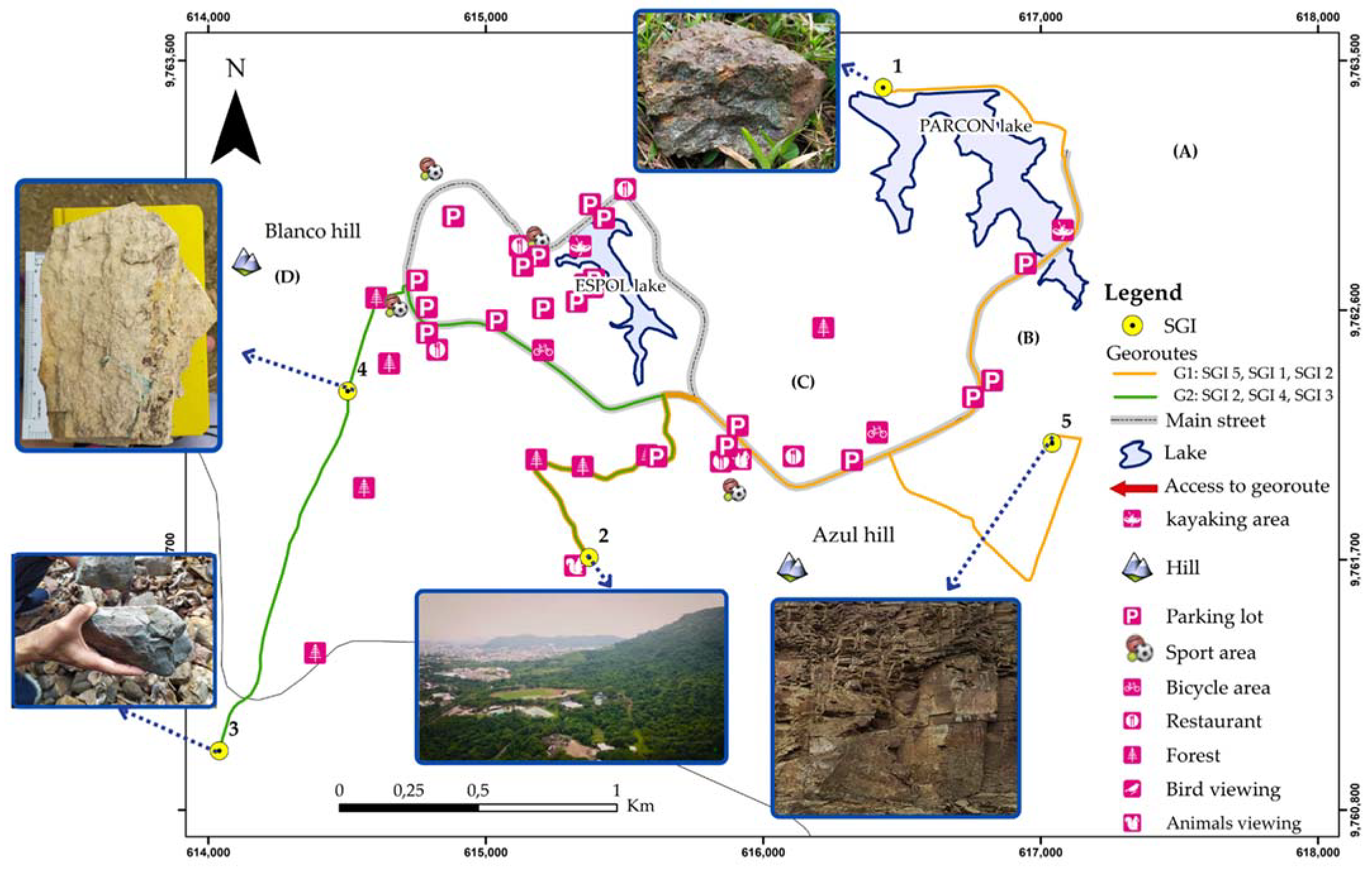
 PP = Is   +   Id   +   It 3 2 ×   SD   × 1 400
PPs = scientific protection priority, Is = scientific interest, SD = susceptibility to degradation, PPd = didactic protection priority, Id = didactic interest, PPt = tourist protection priority, It = touristic interest, PP = global protection priority.
Table 5. List of five sites of geological interest within the university campus.
NoSGIType of Main
Geological
Interest
Main Features
SGI 1Lapilli tuffPetrologic
  • Located at 79 ± 3 m.a.s.l., an outcrop of lapilli tuffs characterises it as ranging from dark grey to greenish grey, rhythmically stratified. The deposit is the product of erosion from an ancient oceanic volcanic arc.
  • It is part of an artificial oligotrophic lake (“albarradas”) fed by rainwater from the Chongón–Colonche hill range, conserving the environment and taking advantage of water resources.
SGI 2“La Prosperina” protective forestviewpointGeomorphologic
  • It is a panoramic point located at 209 ± 3 m.a.s.l. that presents views of part of the Chongón–Colonche hill range, surrounded by several hills, with heights ranging from 40 to 90 m.a.s.l., with gentle slopes and dendritic drainage. Part of the Guayas River can also be seen.
  • It is a site for sighting animals (e.g., howler monkeys) and endemic plants (e.g., Guayacán Negro) in the sector and a suitable place for hiking or leisure activities.
SGI 3Cretaceous–Paleogene
(K–Pg) boundary
Petrologic
  • The site is located at 138 ± 4 m.a.s.l. and represents the Cretaceous–Paleogene (K–Pg) boundary extinction event in the marine setting of Ecuador.
  • The geological units present a direction of N120 E, 23 SW. It is the geological contact between the Cayo formations (made up of tuffaceous shales and interstratifications of lapilli tuffs with volcanoclastic conglomerates) and Guayaquil (siliceous shales with secondary enrichments of chert and jasper nodules).
  • The section of geological interest is located within a seasonal creek, which fills with water during the rainy season (from January to April).
SGI 4Zeolite
outcrop
Petrologic
  • It is in the Chongón–Colonche hill range at 129 ± 4 m.a.s.l., framed in the Cayo Superior formation, part of the sequence of marine deposition volcanoclastic sediments that form Northwest–Southeast orientation stripes, with a direction of N120 E, 15 SW.
  • It has different ages that allow inferring the presence of zeolites from the alteration of the volcanic glass. The characteristic zeolites of the area are heulandite and clinoptilolite.
  • This outcrop is located near a ravine and has deposits of very heterogeneous colluvial and clayey alluvial soils.
SGI 5Volcano-sedimentary rhythmic sequencePetrologic
  • The site is a volcano-sedimentary rhythmic sequence of main shales with alternating breccia, lapilli tuffs, and fine-grained sandstones.
  • The deposit belongs to the intermediate Cayo formation and is the product of the erosion of an ancient oceanic volcanic arc.
Table 6. The overall framework of the assessment of sites of geological interest.
No.GeositesSDTAv.DSVulPPsPPdPPtPP
SGI 1Lapilli tuff15019017017078.3716511.0217.6814.1614.16
SGI 2“La Prosperina” protective
forest
viewpoint
210255245236.674611512.6818.6917.2616.10
SGI 3Cretaceous–Paleogene
(K–Pg) boundary
20520520520534.51159.069.069.069.06
SGI 4Zeolite outcrop26520520520534.511515.149.069.0610.92
SGI 5Volcano-sedimentary rhythmic sequence22519519519563.3719520.0518.3115.0617.75
Table 7. Strengths, weaknesses, opportunities, and threats (SWOT) matrix.
Strengths (S)Weaknesses (W)
Internal
Environment
S1. Under environmental management policies, the SGI are on a university campus within a protected forest.
S2. It has a Geology Engineering degree at ESPOL, and a research centre applied to the topics.
S3. It is one of the main points of green spaces in the city.
S4. Recreational and leisure activities are carried out.
S5. It houses an essential diversity of endemic species.
S6. It has ecological trails with environmental interpretation tools that connect with the SGI.
W1. Lack of research dedicated to the study of SGI.
W2. Lack of exploiting the potential of geosciences.
W3. It lacks strategies for the geotourism development of the SGI.
W4. Logistics and operational services for recreational and leisure activities are scarce.
W5. Limited circular economy management on campus.
W6. A geological cultural value and natural values of the campus are lacking.
W7. Limited by unorganised human settlements.
External
Environment
Opportunities (O)Strategies: S + OStrategies: W + O
O1. Opportunity to develop geotourism and geoeducation to expand the city’s tourist attractions and promote geoeducation in earth sciences.
O2. Other natural values complement the georoutes.
O3. Possibilities for sightseeing in a natural environment and near a perimetral area.
O4. Convert the area into a natural laboratory that combines geology with biodiversity.
O5. A starting point for a geopark proposal for the city.
S2. O4. O5. Preparation of proposals for research projects on enhancing the geological heritage to develop geotourism in the town.
S6. O1. O2. Articulate nature interpretation programs with geological heritage values.
W3.O3. O2. Design a protection and conservation plan that integrates the elements of the natural and geological heritage of the campus.
W4.O4. Strengthen the tourism and geoeducational infrastructure of the campus.
W6.O2. Collaboration between tourism companies and local agencies to promote the routes.
W1. W2. W5. O4. O1. Encourage the development of graduate and postgraduate thesis projects to conserve geoheritage, circular economy and scientific publications in the multi-disciplinary framework.
Threats (T)Strategies: S + TStrategies: W + T
T1. Lack of interest in the development potential of geotourism and geological heritage values.
T2. Anthropic accidents related to the pipeline system limit the area.
T3. Territorial planning affects the natural space.
T4. Disturbances can cause the decline of native or endemic biodiversity.
T5. Security problems in the city affect the development of geotourism.
S2.T1. Stimulate the implementation of initiatives to raise awareness of the geological heritage.
S2. S6.T4. Evaluation of tourist load capacity of the interpretation routes.
S1. S3.T2. T3. Propose the inclusion of geoconservation within the city’s land-use plan.
W3.T1. T3. Strengthen the circular economy system in all the management axes of the campus.
W2.T1. Launch of geoeducational souvenirs at specific points along campus routes to promote education in geosciences.
W3. T1. Creation of a geo-mining museum and itineraries within the campus.
Publisher’s Note: MDPI stays neutral with regard to jurisdictional claims in published maps and institutional affiliations.

