Article

Reclaiming Wetlands after Oil Sands Mining in Alberta, Canada: The Changing Vegetation Regime at an Experimental Wetland

1
School of Biological Sciences, Plant Biology, Southern Illinois University, Carbondale, IL 62901, USA
2
Lake Superior Research Institute, University of Wisconsin-Superior, Superior, WI 54880, USA
*
Author to whom correspondence should be addressed.
Land 2022, 11(6), 844; https://doi.org/10.3390/land11060844
Submission received: 11 April 2022 / Revised: 17 May 2022 / Accepted: 1 June 2022 / Published: 4 June 2022
(This article belongs to the Special Issue Wetland Construction and Restoration: Design and Performance)

Abstract

:
Surface mining for oil sand results in the formation of large pits that must be reclaimed. Some of these pits are backfilled with a myriad of substrates, including tailings rich in cations and anions, to form a solid surface. Experimental reclamation of the East in-pit located on the Syncrude Canada Ltd. mine lease was initiated in 2011 with Sandhill Wetland. Here, we report on monitoring (between 2015 and 2021) of Sandhill Wetland plant communities and significant environmental features, including base cations and water tables. Multivariate analyses demonstrated that the three dominant plant communities established in 2013 have continued to be dominated by the same species nine years after reclamation was initiated, but with reduced species richness. Plant communities have shifted across the wetland in response to water table changes and increases in sodium concentrations. The stoichiometry of base cations is unlike the natural wetlands of the region, and the surficial water chemistry of the wetland is unique. In response to variability in precipitation events coupled with wetland design, water tables have been highly variable, creating shifting water regimes across the wetland. Plant community responses to these shifting conditions, along with increases in base cation concentrations, especially sodium, provide background data for future in-pit reclamation designs. The plant responses underscore the need to develop reclamation designs for landscapes disturbed by mining that alleviate extreme water table fluctuation events and decrease cation concentrations to levels that approach natural wetlands.

1. Introduction

Peatlands are an integral part of the boreal forest landscape, with approximately 24% of the boreal forest worldwide covered by peatlands [1]. Globally, peatlands store between 20–30% of the world’s soil carbon [2,3] and 10% of soil nitrogen [4]. Peat-forming wetlands (bogs and fens) are an important part of the western Canadian landscape, covering approximately 365,000 km2 or 40% of the western boreal forest of Canada [5]. In western Canada, the Oil Sands Region (OSR) occupies approximately 142,000 km2 and has been estimated to hold 1.65 billion barrels of crude oil [6]. The Athabasca Oil Sands Area (AOSA) is the largest deposit in the region (66% of the OSR) and includes a mineable surface area for bitumen of 488,970 ha. Wetlands cover 43% of the AOSA landscape and include 28% fens and bogs and 15% mineral wetlands (swamps and marshes) [7].
Peatlands develop in specific landscape settings and respond to changes in hydrological characteristics of the surrounding landscape, as well as internal autogenic interactions [8]. Three ecological gradients have long been recognized as important in influencing vegetation patterning and peatland development: (1) pH and base cation (and associated anion) concentrations provide the basis for different bog and fen site types, each with specific floral elements [9,10]; (2) water tables and seasonal fluctuations set boundary conditions for the structural aspects of peatland site-types; and (3) ecosystem structure and function, especially decomposition and plant growth, and thus peat accumulation, are influenced significantly by nutrient inputs (N, P) that originate from the surrounding landscape and precipitation [11,12]. Changes in these parameters can affect the functioning of peatlands over short periods resulting in changes in vegetation (or structural aspects) and flora (including species diversity) of individual peatlands.
First recognized by Weber in 1902 [13], bogs are hydrologically isolated from surrounding terrestrial inputs, while fens are closely connected to and influenced by hydrological inputs from associated uplands. Changes in water qualities and quantities, especially those from the inflowing surface and groundwater, can dramatically alter carbon storage, species diversity, and nutrient retention, eventually altering the direction of plant succession and peatland site type. Increases in water table fluctuation and salinity have a considerable influence on whether individual sites will develop as marshes, brackish wetlands, saline wetlands, or riparian meadows [14].
Open pit mining causes extensive disturbance to the landscape, including clearing forests and wetlands, draining or diverting surface and groundwater, and removing tens of meters of overburden. After extracting the bitumen, there remain large, deep ‘in-pits’ filled with composite tailings containing high concentrations of base cations and anions originating either from natural sources or from process waters with high salinity levels. Provincial legislation mandates the reclamation of previously mined areas back to equivalent land capability following mining closure [15]. Hence, appropriate protocols for reclaiming wetlands are a focus for many oil sand mining companies. Among the many challenges that exist in these reclamation efforts are providing suitable water quality and quantities that support appropriate wetland plant species [16] and function from an integrated hydrological perspective [17,18]. To test the geotechnical feasibility of constructing a watershed capable of supporting a wetland placed on a composite tailings deposit, an experimental watershed containing a wetland (Sandhill Wetland-SHW) was constructed, with water and plants introduced in 2012 [19].
The importance of monitoring the vegetation and hydrological changes at Sandhill Wetland is that future wetland reclamation sites will be constructed above previously mined in-pits that contain saline-sodic substrates, wherein the diffusion and attenuation of sodium (~1100 mg Na L−1) have not been shown to lessen by overburden depth in the first four years [20,21]. During the first nine years of post-wet-up development, the vegetation and hydrology at SHW have changed. Previous research has centered on hydrological processes and has generated considerable information on early aspects of the watershed. For example, Nichols et al. [22] showed the hydrological fluctuations of SHW during two normal rainfall years, 2013 and 2014. The inflow/outflow pumping of water contributed significantly to the hydrological fluxes in 2013; however, the artificial addition of water was negligible in 2014. The evapotranspiration rates at SHW were similar between years but were lower than older nearby upland systems. After 2014, hydrological management efforts declined, and Spennato et al. [23] found that while the water tables at SHW were on average greater than those observed in natural analogues, the lowland features at SHW exhibited similar functions of lateral flow reversals to natural systems. Among the trends reported over the past seven years has been an increase in concentrations of sodium supporting the continued upward transport of underlying process-affected water [18,24].
The predicted high concentrations of sodium at Sandhill Wetland were a critical component in selecting appropriate wetland plants to form the foundational vegetation of the developing wetland. Among potential candidate plant species, several appeared to be of interest. The broad tolerances of Carex aquatilis (water sedge) to a series of natural environmental gradients [25] suggested that it was a species of interest for in-pit reclamations, and its tolerances to sodium were examined in greenhouse studies [26,27]. Additionally, tolerances to sodicity were examined for a widespread, early successional species, Beckmannia syzigachne (slough grass) [28], and for Typha latifolia (broad-leaved cattail) [29], showing decreased morphological performance with increased sodium concentrations, notably above 850 mg L−1 and 300 mg L−1, respectively. Early colonization from local sources by species of bryophytes was confirmed by Vitt and House (2015) [30]. After three years post-wet-up, the wetland was composed of four distinct plant assemblages with distributions mostly related to wetness [31]. Hartsock et al. [32] evaluated the porewater chemistry from decadal monitoring stations present at SHW, with comparisons to provincial water quality guidelines and the chemistry of natural wetlands. Additionally, Hartsock et al. [33] compared the vegetation and surficial water chemistry present in 2018 at SHW to that of regional natural wetlands, concluding that SHW was most similar to brackish marshes. Similarly, Biagi et al. [34] reported the lack of peat profile stratification and the suggested absence of water-conserving feedback mechanisms were likely to facilitate marsh development.
Here we examine the development of vegetation on Sandhill Wetland over a period of three to nine years post-wet-up and how vegetation change has affected species richness and plant occurrences on the wetland. We also provide summaries of salinity and water table variation changes that may have influenced the temporal changes in vegetation responses since wet-up. In particular, from our annual monitoring data obtained 3–9 years post-wet-up, we examine plant abundances, base cation concentrations, and water tables at SHW to: (1) examine the development of plant communities on the wetland; (2) determine what components of these early communities changed; (3) follow the changes in spatial shifting distributions of these early plant communities; and (4) understand how plant community evolution on the wetland has been associated with variations in water chemistry and water tables. This work follows that presented in Vitt et al. [31] and Hartsock et al. [33], which assessed earlier vegetation patterns, while this more comprehensive study assesses the temporal and spatial evolution of plant communities that originated on the wetland after wet-up.

2. Materials and Methods

2.1. Study Site

2.1.1. Weather

The 2013–2021 average annual (1 October–30 September) precipitation was 376 mm. It was 326 mm for the growing season (1 May–30 September). Between 2013 and 2021, growing season precipitation varied from 251 mm (2021) to 436 mm (2020), with 2013, 2016, 2018, and 2020 above the average precipitation (wet years) during the growing season and 2014, 2015, 2017, 2019, and 2021 below the average (dry years). Over these nine years, four rain events of over 50 mm occurred: a 92 mm event on 21 July 2018, two events of 54 mm (on 9 July) and 58 mm (on 3 September) in 2016, and a 54 mm event on 31 August 2021. Air temperatures (mean 1 June–1 October) varied from 12.1 °C (2016) to 16.2 °C (2021). Data from 2013–2018 from the meteorological station on-site come from Biagi et al. [18,34] 2021 McMurray Airport—https://acis.alberta.ca/weather-data-viewer.jsp accessed on 18 November 2019.

2.1.2. Site Characteristics

Sandhill Wetland (SHW) is located approximately 40 km north of Fort McMurray, Alberta, on Syncrude Canada’s oil sands lease at 57°02′16.10″ N, 111°36′06.09″ W, and 57°02′29.03″ N, 111°35′06.37″ W. The wetland was constructed on a former in-pit mined from 1977 to 1999. Subsequently, it was filled with consolidated tailings and tailings sand [35]. The 10 m tailings sand cap was overlain by 0.5 m of clay till and 0.5 m of fresh peat harvested from a nearby peatland slated for mining with mixed characteristics, including microsites having bog and rich fen vegetation. Peat placement was completed in January 2011. The site consists of a 52 ha watershed consisting of constructed upland hills and a central 17 ha wetland.

2.1.3. Water Management

Sandhill Wetland was designed to maintain wetness and mitigate salinity levels by controlling the inflow and outflow of water through a system of underdrains and pumps and landform design features [19,36]. The system allows freshwater to be supplied from a nearby undisturbed lake, while outflows can be introduced to the surrounding reclaimed areas. Outflows can only occur when the outflow pumps are activated [19,34]. The water inflow only occurred during 2013, with a small amount in 2014. During these two years, outflow volumes were similar to inflows [34]. In 2015, a dry year, outflow pumps released 55 mm of water over 60 h. In 2016, a wet year with two rain events over 50 mm on 9 July and 3 September, outflow pumps remained off, increasing water tables in the late season [34]. An unusually wet spring in 2017 with several rain events between 20–40 mm increased water tables. Throughout this period, outflow pumps remained off, creating extremely high water tables throughout the wetland. In mid-summer 2017, outflow pumps were turned on, releasing some 17,000+ m3 of water and lowering water tables by about 102 mm [34]. In 2018, another year with several spring rain events above 20 mm and the 21 July event of 92 mm again raised water tables that were lowered some 210 mm with outflow pumping [34]. Although data on outflow pumping are unavailable for 2019–2021, high water tables were maintained over the wetland in 2019–2020 due to high precipitation totals. In 2021, water tables were much reduced to the lowest levels observed on the wetland, leaving many areas with water below the soil surface.

2.1.4. Early Vegetation Structure: Years 1–3

In November 2011, a native seed mix was spread across the wetland. The seed mixture contained the following species: Carex aquatilis, Carex diandra, Carex utriculata, Scirpus atrocinctus, Carex bebbii, Carex paupercula, Scirpus microcarpus, Carex lasiocarpa, Carex rostrata, Carex limosa, Carex interior, and Juncus tenuis. Eighty percent of the seed mixture was comprised of Carex aquatilis [31]. In the spring of 2012, 16 plant introduction plots were established and planted with a variety of greenhouse-grown wetland plants. In the spring of 2013, additional species were introduced to these plots. The site remained dry until August 2012, when water was introduced from a natural lake through a series of pipes and a water storage pond [19], with continued additional water inputs in 2013 [19,34]. Thus, 2013 was the first full year of adequate water available for plant growth.
In 2013, plant establishment was limited, with only scattered individuals of graminoids, occasional annual upland weeds, and cattails present on the site. By 2014, plant abundances had increased, with mean vascular plant cover in the wetland area reaching 65% [30]. Vascular plant cover increased in 2015 to between 90–100% cover, with three distinct plant assemblages zonally distributed on the wetland. The main three zones were characterized by different dominant plant species and different water tables. The wettest zone, with persistent standing water, was dominated by Typha latifolia; the second zone with water tables close to or at the peat surface for most of the growing season was dominated by Carex aquatilis, and the third zone with water tables well below the peat surface was dominated by Calamagrostis canadensis [31].

2.2. Methods

2.2.1. Vegetation and Plant Communities

Using a grid of 78–87 (depending on annual access) permanent plots centered at 40 m intervals across SHW, we conducted annual vegetation surveys in early August from 2015–2019 and 2021, representing years 3 through 7 and 9 following the introduction of water to the wetland. No sampling occurred in 2020. We present plant community and environmental data for four of these seven years, beginning in 2015 and continuing through 2017, 2019, and 2021. At each grid point we identified all plants (vascular plants and bryophytes) within a circular 8 m2 plot and estimated abundances to the nearest 5% using the same personnel and following the identical protocols in Vitt et al. [31].
Plant species abundances from each plot were utilized in a Bray-Curtis nonmetric multidimensional scaling (NMDS) ordination with 25 restarts using field-derived abundance data. Group average cluster analyses to delineate plant communities were performed each year. Similarities for the four major clusters ranged from 30–45% (Supplementary Materials Figure S1). PERMANOVA was used to test whether a priori groups (e.g., plant communities) differed among years [37]. A two-way PERMANOVA was used, testing groups (plant communities) determined by the cluster analyses and year. Both were fixed effects. Pair-wise tests were then used to determine which groups and years differed. Abundances for the three most abundant plant species were overlain as segmented bubbles on the yearly ordinations.
Species richness was evaluated through four measures: (1) alpha diversity is the number of species recorded in individual plots; (2) gamma diversity is the total number of species in a group; (3) beta diversity is a measure of the amount of variation in species composition or species turnover between plots calculated as gamma divided by alpha [38]; and (4) additionally, we used Pielou’s J as a measure of evenness [39]. Since bryophytes occurred only in low abundances, the frequencies of bryophyte species were estimated by summing the number of occurrences of all species in the sampled plots.
Linear regression was used to analyze the abundance of dominant species (Calamagrostis canadensis, Carex aquatilis, and Typha latifolia) across the entire wetland [40].

2.2.2. Water Chemistry

In 2011, 10 water samplers that allowed wetland water to be collected in 10 cm intervals to 50 cm depth were installed in the wetland area. In 2015, we added 16 additional samplers across the site to better capture spatial water chemistry patterns. Each sampler consisted of 5 sections of thinly slotted 2.5 cm-diameter PVC pipe. We report here on water collected in early August of each year from the surficial 10 cm segment. In 2019, we sampled near-surface water from each of the gridded vegetation plots, either from standing surface water or from shallow pits dug in the peat. Samples were filtered immediately through Whatman 541 filter paper into acid-washed Nalgene bottles and refrigerated. In the laboratory, water samples were analyzed for pH using an Accumet AB15 pH meter, electrical conductance (EC) using an Orion 4 Star EC meter, and Na+, Ca2+, and Mg2+ using a Varian 220 FS atomic absorption spectrophotometer.

2.2.3. Water Tables

Water tables vary between years [34] and over the growing season, with seasonal highs in May and early June due to snowmelt and influxes from surrounding uplands. Water tables decrease over the growing season and stabilize in July and August, periodically recharged from summer storm events [34]. We measured water tables during vegetation surveys in 2016–2019 in early August, during a period without precipitation during the previous week. Our data reflect a growing season relative water table for mid-summer each year. Water tables at each gridded plot were measured relative to the soil surface with a 30 cm ruler. We placed the measurements into five categories representing: deep water (40.1–100.0 cm) above the soil surface, shallow water (10.1–40.0 cm) above the soil surface, water just above the soil surface (0.1–10.0 cm), moist soil with water near to just beneath the soil surface (0.0–−9.9 cm), and dry soil with water −10–−50 cm beneath the soil surface.

2.2.4. Spatial Analyses

Distributions of plant communities and dominant species, sodium, and water tables were mapped using data from the gridded plots and/or water sampler locations. Georeferenced points were created from coordinates recorded at the surveyed locations using a handheld Garmin Montana 680 GPS unit. Maps were generated in ArcMap version 10.6.

3. Results

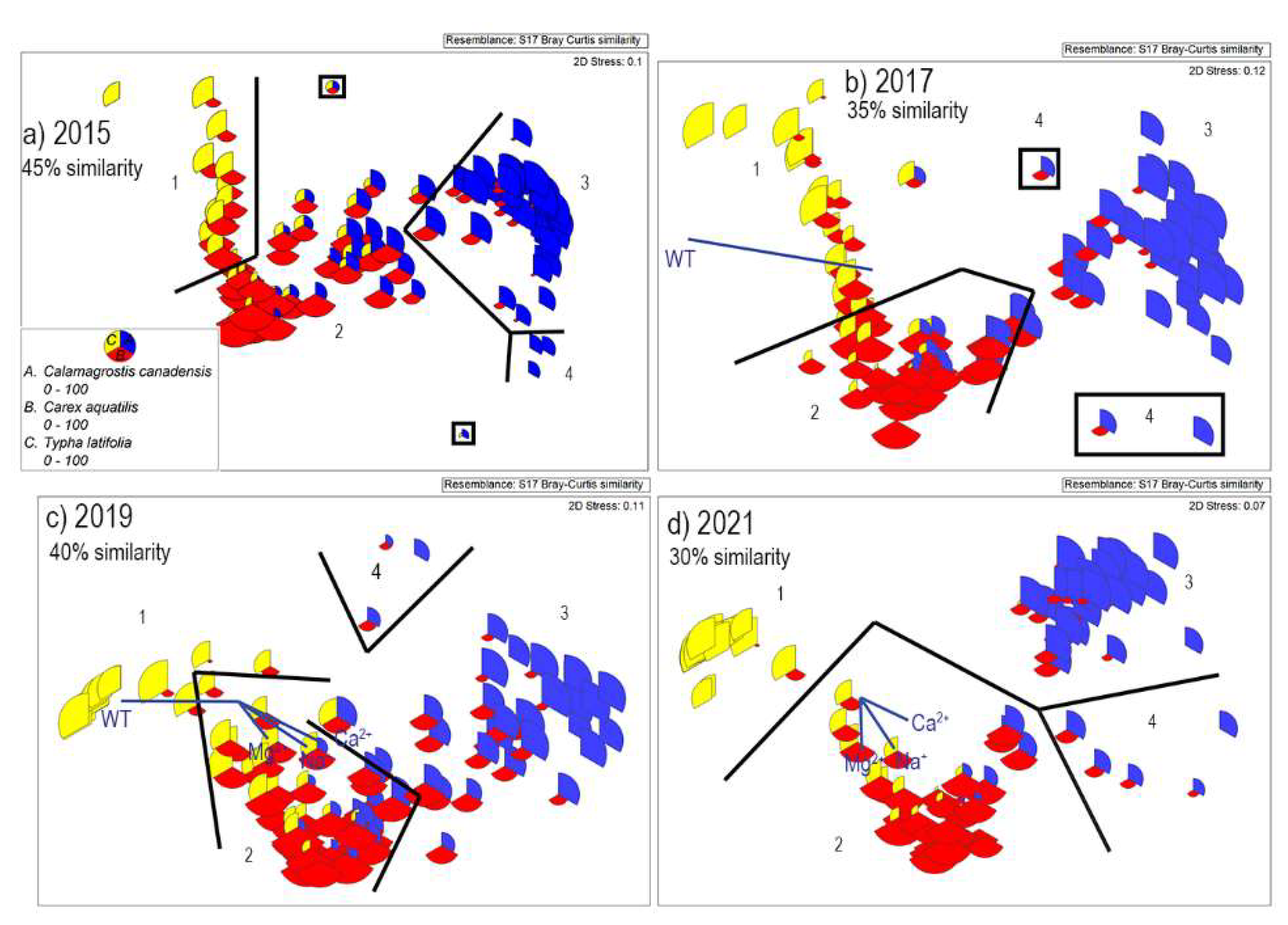
3.1. Plant Communities on Sandhill Wetland

Although we sampled vegetation at Sandhill Wetland annually between 2015–2019 and in 2021, we present data for alternate years—2015, 2017, 2019, and 2021—as representative across the seven years. Across all years, four plant communities are different from one another (Group average cluster analysis at 30–45% similarity (Supplementary Materials Figure S1) and PERMANOVA p = 0.001). The four communities also differ between years (PERMANOVA p = 0.001), and there is a significant interaction between plant community and year (PERMANOVA p = 0.001). The four communities ordinate along the x-axis correlated to wetness and base cation gradients (Figure 1a–d, the significant vectors (as determined by a > 0.2 Pearson correlation) shown for the years 2017, 2019, and 2021). Pair-wise tests revealed that all four plant communities were significantly different across the four years analyzed. Comparing yearly data within plant communities (using pair-wise tests), differences were found. Plant community 1, dominated by Typha latifolia, all years differed except for 2015 and 2017. For plant community 2, dominated by Carex aquatilis, 2015 differed from the other 3 years. Years 2017 and 2021 differed. However, 2017 did not differ from 2019, and 2019 did not differ from 2021. Plant community 3, dominated by Calamagrostis canadensis, all 4 years differed. For plant community 4, dominated by other species as described below, no years were significantly different.
Plant community 1 consists of plots having high abundances of Typha latifolia, with Carex aquatilis and Utricularia minor occurring in low abundances. Overall, these plots are species-poor.
Plant Community 2 consists of plots with high abundances of Carex aquatilis. Other abundant species in this plant community include Carex utriculata (in ±50% of the plots), Calamagrostis canadensis (in ±25% of the plots), Salix petiolaris, and Typha latifolia (in 40–45% of the plots in low abundance).
Plant Community 3 has high abundances of Calamagrostis canadensis. Other important species in this community include Carex aquatilis (occurring in low abundances in about two-thirds of the plots), Carex atherodes (occurring in 10–15% of the plots), Carex utriculata (occurring in one-third of the plots), Populus balsamifera, Salix monticola, and Salix petiolaris.
In 2015, five plots were dominated by other species. One plot was characterized by the presence of Carex atherodes, one plot was characterized by Carex utriculata, and three plots were characterized by a suite of species found in dry areas of the wetland: Poa pratensis, Epilobium angustifolium, Melilotus alba, and Sonchus arvensis (Figure 1a). In 2017, these outlier plots comprised three plots. Two of these plots were characterized by the presence of Carex atherodes (Figure 1b—on the lower right of the ordination), and the third plot had low species cover overall. In 2019, three plots were characterized by the presence of Carex atherodes (Figure 1c). In 2021, outliers consisted of five plots: Two plots characterized by Carex atherodes, two plots characterized by Carex utriculata, and the fifth characterized by the presence of both Carex atherodes and Carex utriculata (Figure 1d).
Overall, the most abundant plants on SHW are Typha latifolia, Carex aquatilis, and Calamagrostis canadensis. We plotted the abundances of these dominant species as recorded in each of the four years of vegetation surveys on the yearly ordinations (Figure 1a–d). These three species consistently remained dominant in the wetland throughout the study period, with the three plant communities remaining distinct. However, the spatial distributions of the plant communities and abundances of dominant species in individual plots changed over the years.

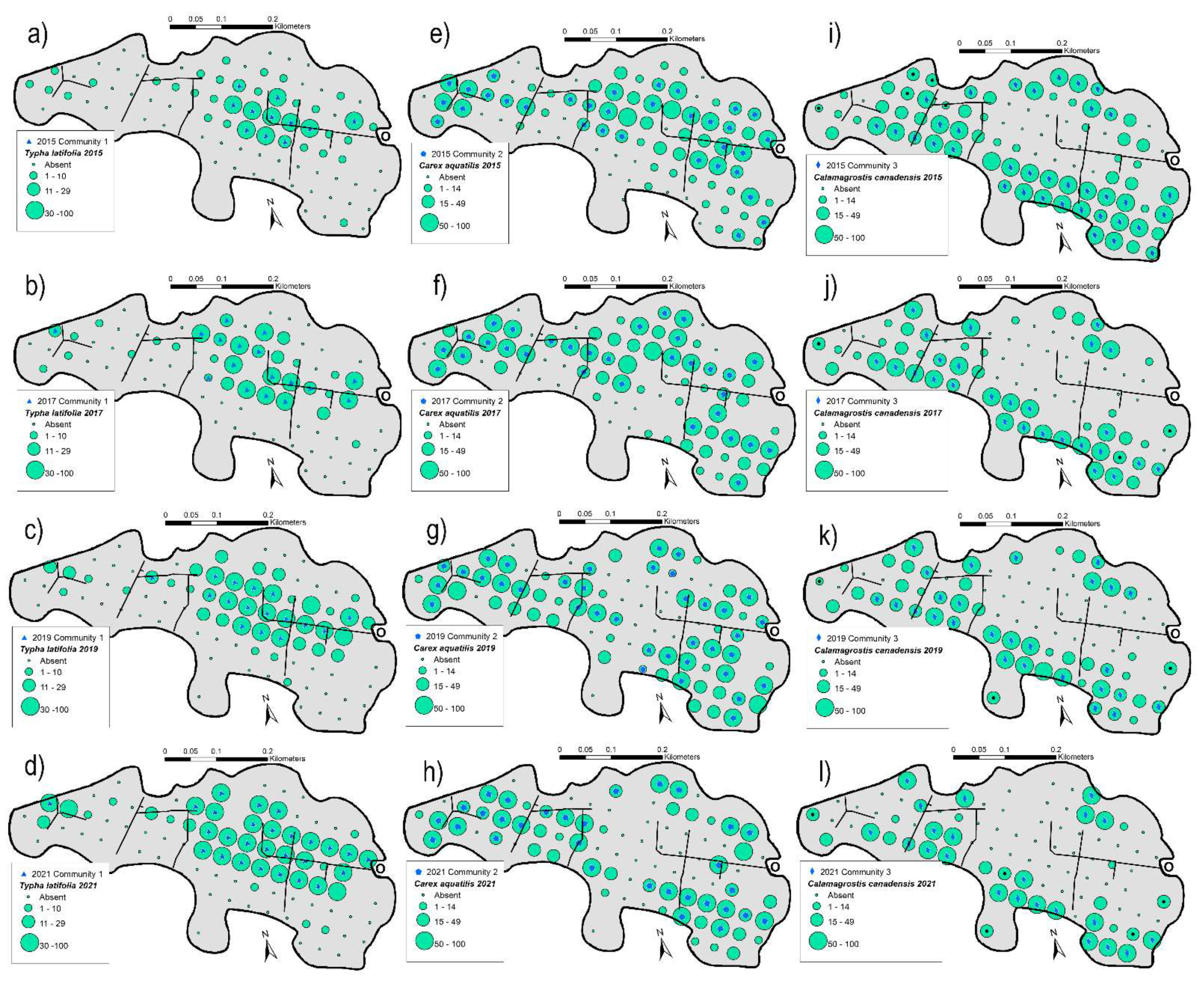
3.2. Spatial Changes of Plant Communities

Plots in Plant Community 1, with high abundance of Typha latifolia, increased from 11 plots in 2015 to 26 in 2021 (Table 1), with the greatest increases in 2017 (11 to 17) and 2021 (16 to 26) (Table 1). These plots occupy the central portions of the wetland, and over the seven years have expanded outward into areas dominated by Carex aquatilis (Figure 2a–d). Over the seven years of sampling, overall abundance of T. latfolia on the wetland significantly increased from 6% cover in 2015 to 26% cover in 2021 (p = 0.018, r2 = 0.791).
The number of plots in Plant Community 2, with high abundance of Carex aquatilis, has remained relatively stable over the seven years (Table 1); however, in the central portions of the wetland, individual plots dominated by C. aquatilis in 2015 have been replaced by those dominated by Typha latifolia, while plots located in drier areas dominated by Calamagrostis canadensis in 2015 have been replaced by those dominated by C. aquatilis in 2021 (Figure 2e–h). Overall, the abundance of C. aquatilis remained the same over the seven years (p = 0.693, r2 = 0.043).
In 2015, Plant Community 3, with a high abundance of Calamagrostis canadensis, occurred in just over one-third of the plots (37 total), including much of the marginal areas on the northern and southern sides of the wetland. By 2021, the number of plots with a high abundance of C. canadensis decreased to 22 plots, or about one-fourth of the plots (Table 1). Many C. canadensis-dominated plots transitioned into Carex aquatilis-dominated plots in later years. Especially noteworthy is the loss of C. canadensis-dominated plots along the northern boundary of the wetland (Figure 2i–l); however, the overall abundance of C. canadensis on the wetland did not significantly decrease (p = 0.063, r2 = 0.621).

3.3. Bryophyte Species Richness

Over the entire wetland, bryophyte species richness declined over the seven years, with the number of occurrences decreasing from 316 in 2015 to 74 in 2021 (Table 2, Supplementary Materials Table S1). In 2015, 64 (74%) of the 87 sampled plots had at least one species, and 20% of the plots had more than five species. Comparatively, in 2021, 18% of the plots had at least one species, and only 3% of the plots had more than five species. Along with the decrease in the number of occurrences, alpha diversity decreased from 4.5 to 3.3 species, and gamma diversity decreased from 24 to 13 bryophyte species found on the wetland. In 2015, bryophyte gamma diversity varied from zero in T. latifolia-dominated plots to 18 species in C. aquatilis-dominated plots and 19 in C. canadensis-dominated plots. This diversity declined over the seven years by 50% to 9 species in C. aquatilis plots and by 32% to 13 species in C. canadensis plots. The greatest decrease in the number of species was in 2017 (Table 2). Bryophyte beta diversity (Table 1) could only be calculated across the years for C. canadensis-dominated plots. Here, the bryophyte beta diversity gradually increased from 3.9 in 2015 to 6.5 in 2021, indicating a gradual increase in species turnover between plots.
In 2014, only two years after the wet-up, a diverse set of bryophyte species was present in the wetland. Sixty-six of the 87 sampled plots had at least one species, and 18% of the plots had more than five species [30]. This high diversity and frequent occurrence of species continued through 2015–2016. Beginning in 2017, the number of plots with no bryophytes increased from 29 to 58, with species occurrence decreasing by 30%; however, overall species richness at both the plot and site levels remained steady. The number of plots with high diversity also remained similar to past years. In 2018, site species richness declined from 25 to 17 species, occurrences from 182 to 124, and high diversity plots from 19 to 8. This decline continued through 2021, and by 2021, 71 (or 82%) of the plots contained no bryophytes. During the first 3–4 years, the developing bryophyte ground layer contained a highly diverse set of fen species. In 2017 and 2018 and associated with high water tables that created more areas of standing water, along with higher sodicity, the number of bryophyte occurrences decreased substantially; however, site diversity was less affected, suggesting that there are a low number of local habitats on the wetland that have remained suitable for bryophytes and may continue to support a healthy, but limited bryophyte flora.

3.4. Vascular Plant Species Richness

In 2015, 96 species of vascular plants occurred on the wetland, declining to 44 in 2021 (Supplementary Materials Table S2). However, this marked decline was not uniform across the three plant communities. In T. latifolia-dominated areas, species richness (gamma diversity) declined from nine species to five in 2021. Comparatively, in C. aquatilis-dominated areas, gamma diversity declined from 68 species in 2015 to only 17 species in 2021 (a 75% decrease in the number of species). In C. canadensis-dominated areas, richness declined from 73 species in 2015 to 38 species in 2021 (a decrease of 48%). Alpha diversity followed similar trends. Overall, species richness declined 45–46% in T. latifolia- and C. canadensis-dominated plots and by 75% in C. aquatilis-dominated plots. This large decrease is especially evident in 2017 in C. aquatilis-dominated plots when richness decreased from 86 species to 37 (60%) (Table 1).
Beta diversity for vascular plants, a measure of species turnover between plots, varied across years within communities but was consistently different between communities, with the least species turnover evident in T. latifolia-dominated plots and the most turnover in C. aquatilis-dominated plots (Table 1).
Pielou’s measure of species evenness declined in two of the three plant communities. In T. latifolia-dominated plots, evenness declined from 0.46 in 2015 to 0.08 in 2021. Evenness also declined (but less so) in C. aqutilis-dominated plots declining from 0.45 (2015) to 0.37 (2021), while C. canadensis-dominated plots remained relatively stable, varying from 0.50 in 2021 to 0.65 in 2019 (Table 1).

3.5. Environmental Gradients at Sandhill Wetland

3.5.1. Stoichiometric Comparisons of Base Cations at Sandhill Wetland to Natural Sites

Natural occurring rich fens have surficial (0–10 cm depth) water chemistry dominated by divalent cations (Ca2+ and Mg2+), whereas brackish wetlands (marshes on shallow peat and fens on deep peat) have waters dominated by Na+ (Figure 3). In general, divalent cations at natural rich fen sites are present in concentrations less than 2 mmol L−1, while brackish sites have divalent concentrations up to 4 mmol L−1. Comparably, natural rich fens have Na+ concentrations mostly below 1 mmol L−1 but up to 2 mmol L−1 compared to brackish wetlands with higher concentrations of Na+ (4–10 mmol L−1) (Figure 3). Wetland sites in Alberta traditionally classified as saline wetlands (or saline fens or saline marshes) have surficial waters dominated by Na+ (>20 mmol L−1) and are better recognized as sodic wetlands. These cation-rich wetlands also have somewhat higher concentrations of divalent cations (<20 mmol L−1) but with Na+ concentrations about 10 times those of the divalent cations (Figure 3).
Like sodic wetlands and unlike natural rich fens, the surficial waters at Sandhill Wetland have high concentrations of Na+. Still, the stoichiometric ratio to divalent cations is quite different (calculated on a mass basis—mmol L−1). At SHW, the ratios of Na+ to Ca2+ + Mg2+ range from 1.7 (2017–2019) to 3.7:1 (2021) (Table 3), with most sites having ratios centered on a ratio of 3:1 in 2021, compared to ratios between 6–10:1 for natural sodic wetlands (Figure 4). When SHW waters are compared to natural rich fens and brackish wetlands, they differ in higher divalent cation concentrations (5–20 mmol L−1 compared to <2 mmol L−1 for natural rich fens) (Figure 4).

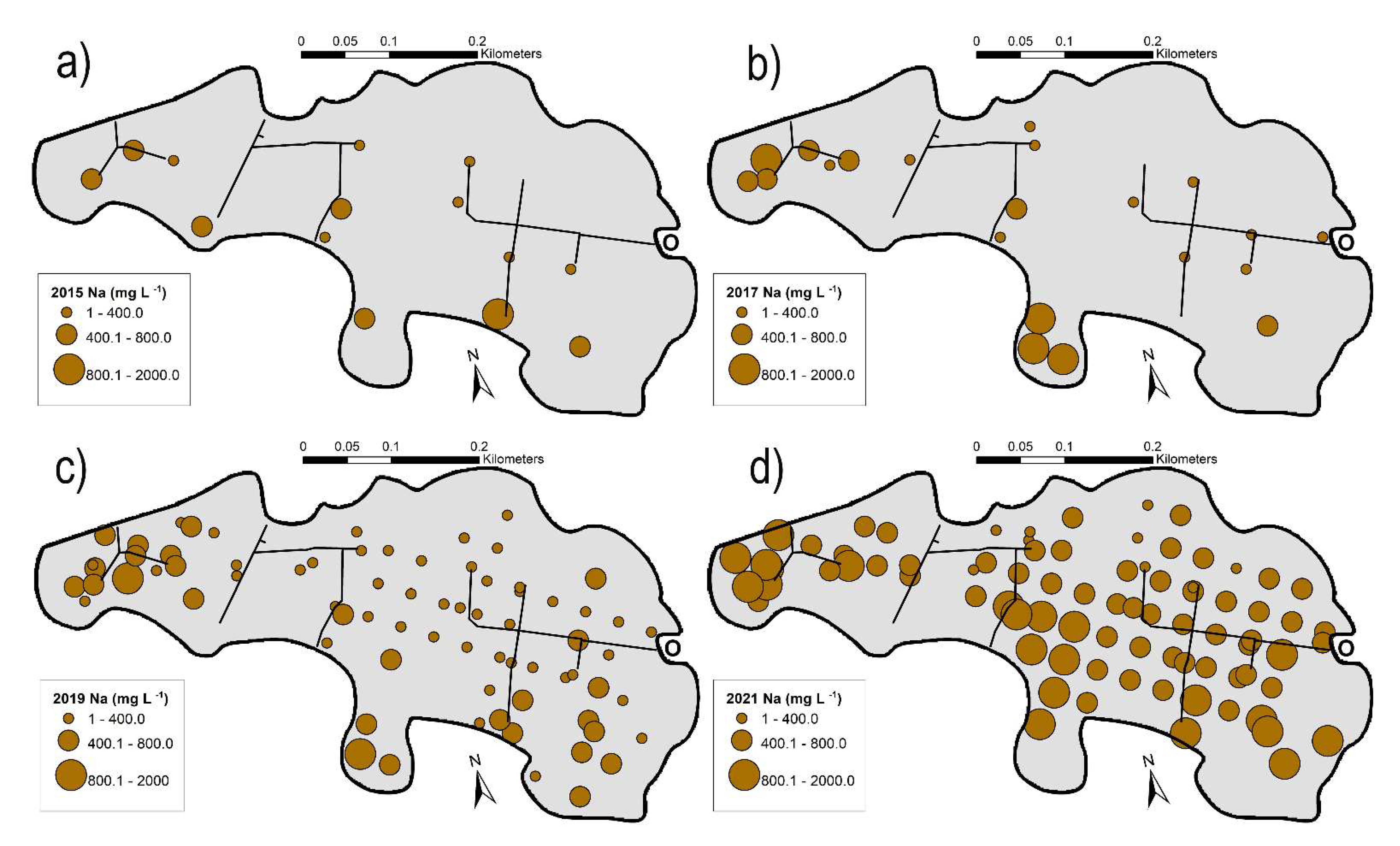
3.5.2. Variation of Base Cations and pH of Surficial Waters

The pH of surface water at Sandhill Wetland has varied little over the years, with means varying from 7.9 to 8.1. In contrast, surface water Na+ concentrations have increased over the years (Table 3). In 2015, Na+ concentrations ranged from 89 to 476 mg L−1 (n = 14, mean: 379 mg L−1). Comparatively, in 2021, Na+ ranged from 64 to 1950 mg L−1 (n = 83, mean: 705 mg L−1). During these seven years, Na+ concentrations at sites in the central portion of the wetland have remained at the lowest levels, while sites in other parts of the wetland have increased concentrations, expanding the variation present on the wetland (standard deviation of 267 in 2015 and 319 in 2021). In all four years of data presented here (Figure 5a–d), the highest concentrations of Na+ are along the southern margin of the wetland. In 2015, only one (7%) of the 14 sites sampled had concentrations over 800 mg L−1, while in 2017, four (19%) out of 21 sites sampled were over 800 mg L−1. In 2019, 27 sites (38%) had Na+ concentrations above 400 mg L−1, with 2 sites (3%) out of 72 exceeding 800 mg L−1. Comparably, in 2021 70 (89%) of the 79 sites sampled were over 400 mg L−1, with 21 (27%) greater than 800 mg L−1. This increase in Na+ concentrations between 2019 and 2021 is evident across the wetland (compare Figure 5c,d).

3.5.3. Variation in Na+/Ca2+ + Mg2+ Ratios

Between 2015 and 2021, Na+ concentrations increased 1.9 fold. Divalent cations increased from 213 mg L−1 in 2015 to 262 mg L−1 in 2021 (Table 3), a 1.2 fold increase in mean values. In 2015 on a mass basis, the ratio of mean Na+ to divalent cations was 2.6 compared to 3.7 in 2021. On a charge basis (meq L−1), Na+ has increased in proportion to divalent cations, representing 57% in 2015, compared to 66% in 2021.

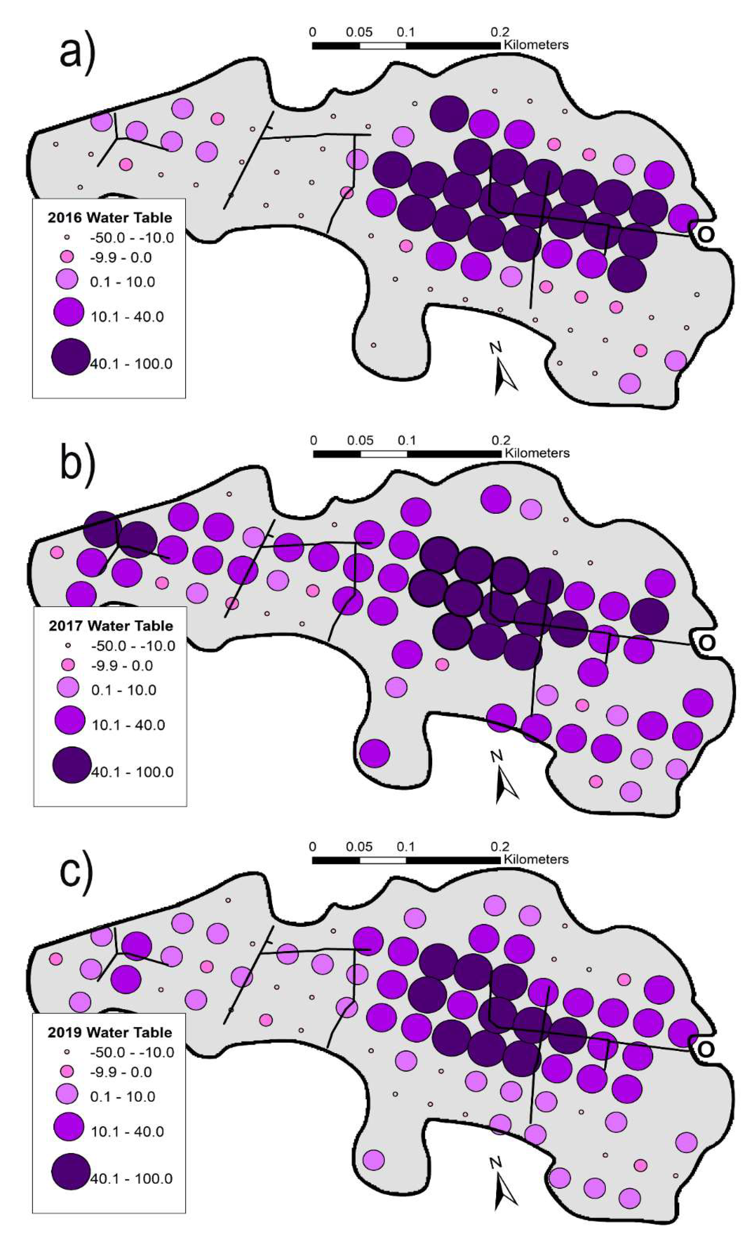
3.5.4. Variation in Water Tables

Water tables in early August varied from 92.5 cm above the soil surface to 50 cm below the surface (Figure 6a–c). In 2016 (our first year of water table data), 42% of the sampled plots had water tables 10 cm or more below the soil surface (dry plots), while 34% of the plots had water 10 cm or more above the soil surface (wet plots). Twenty-four percent of the plots had water near the soil surface (10 cm above to 10 cm below the surface—moist plots). Increases in 2017 water tables are quite clear, whereby dry plots decreased to 10%, wet plots increased to 68%, while moist water tables remained similar (22%). Both 2018 and 2019 were wet years with relatively high precipitation totals. In 2018, outflow pumps decreased water tables to some degree. Dry plots increased to 23%, wet plots decreased to 39%, and moist plots increased to 38%. Overall, sites with water tables above the soil surface increased from 46% in 2016 to 82% in 2017 and 71% in 2019. In 2017, and continuing into 2018–2019, the increase in wet habitats favorable to T. latifolia-dominated plant communities allowed this plant community to expand, while the decrease in dry habits favorable to the C. canadensis-dominated community allowed the C. aquatilis-dominated plant community to expand, albeit with attendant losses to the expanding T. latifolia-dominated community.

4. Discussion

4.1. Changing Plant Communities

Plant communities 1, 2, and 3 dominated by Typha latifolia, Carex aquatilis, and Calamagrostis canadensis, respectively, remained distinct in ordination space over the seven years of assessment. A few plots dominated by additional species also persisted in the wetland. The number of plots where Carex atherodes (a potential valuable species for saline habitat reclamation [27]) increased over time. Each of the three main plant communities continued to be dominated by the same species; however, many individual plots exhibited plant composition changes. For example, in 2015, 11 plots located in plant community 1 (dominated by T. latifolia) increased to 26 in 2021. Likewise, in 2015, plant community 3 (dominated by C. canadensis) had 36 plots which decreased to 20 in 2021. Spatial changes between 2015 and 2021 were: (1) C. canadensis-dominated areas decreased, becoming restricted to drier habitats at the margins of the wetland, (2) C. aquatilis-dominated areas overall remained steady, but migrated toward the drier margins—losing plots to the wetter interior and gaining plots towards the site margins, and (3) T. latifolia increased in areas with higher water depths, replacing plots with C. aquatilis. These community changes were coupled with a large reduction in species richness and a general loss of infrequent species on the wetland. In particular, alpha diversity in the Carex aquatilis-dominated plots decreased from 14.6 to 3.6 species at the plot level and from 86 to 26 at a whole site level, a loss of over two-thirds of the wetland flora. Alpha diversity declines were also evident in T. latifolia-dominated sites (9 species to 5). In the C. canadensis-dominated areas, total site richness decreased from 92 to 51 species. Additionally, between 2015 and 2021, there was a loss of between 39–48% of the vascular plant flora and 30–50% of the bryophytes from the wetland. These species extinctions have increased species turnover between plots and decreased evenness. Current levels of species richness at Sandhill Wetland are well below those reported for fens in Alberta [41,42,43].
Most concerning was the dramatic loss of bryophytes, with decreases at the plot level of 3.3 and 4.9 in 2015 to 0.7 and 2.0 in 2021 for C. aquatilis- and C. canadensis-dominated communities, respectively. Bryophytes are an important part of peatland ecosystems, and both bogs and fens have ground layers with 90–100% cover of bryophytes [44]. In a review of primary production for wetlands of western Canada, Campbell et al. [45] estimated that for fens and bogs, the bryophyte ground layer provides approximately 41% of the total annual plant production. Comparatively, bryophytes are absent or rare in wetlands with shallow open water, marshes, and saline wetlands, with essentially no contributions to primary production [44,46]. Additionally, the developing peat column of fens and bogs is composed of un-decomposed fragments of bryophytes along with vascular plant litter and roots. Analysis of macrofossils from a 700 cm-long peat core from a rich fen in northeastern Alberta showed bryophytes composed between 40 and 80% of the identifiable macrofossils [46]. In comparison, marshes, swamps, and occasional sedge-dominated rich fens have peat deposits composed of roots and litter, with higher bulk density and high amounts of debris [47].

4.2. Changing Water Chemistry

Until 2018, porewaters at Sandhill Wetland had higher concentrations of divalent cations compared to Na+ with, in general, ratios of Na+ 0.3–0.8 to 1 Ca2+ + Mg2+ (data for 2018 not shown). After 2018, Na+ concentrations have been somewhat higher (1.1–1.2:1.0) than those of Ca2+ + Mg2+. These changing stoichiometric base cation ratios may play an important role in limiting species occurrences on the wetland.
Comparing cation surficial water concentrations at SHW to those from brackish and saline (sodic) wetlands and natural rich fens reveals that SHW has unique water chemistry. In the early years, porewaters at SHW had higher concentrations of divalent cations compared to Na+ [24]. In 2015 and onward, Na+ concentrations have increased at a greater rate than those of divalent cations, increasing the sodicity of the wetland. Natural sodic and brackish wetlands are dominated by Na+ with comparatively low concentrations of divalent cations, whereas natural rich fen waters are characteristically dominated by Ca2+ and Mg2+ [48], but at lower concentrations compared to brackish and sodic wetlands [33,49]. In comparison, Na+ concentrations at SHW currently are lower than most sodic wetlands, yet divalent cation concentrations are higher than brackish and natural rich fens. The stoichiometric ratios are quite different from sodic, brackish, and natural rich fens. Therefore, on a charge basis (meq L−1), divalent ions have a similar effect on salinity (and expressed as electrical conductance) as do those of Na+. Greenhouse studies have demonstrated that Carex aquatilis [26,27,50], C. atherodes [27], and Typha latifolia [29,51] may have reduced performance at Na+ concentrations currently present in some areas of SHW; however, no one to our knowledge has examined wetland plant responses to high Na+ in the presence of high divalent cations.

4.3. Changing Water Tables

Water table maintenance across Sandhill Wetland has been challenging, with water tables controlled by a balance of precipitation and evaporation coupled with variations in annual precipitation, along with sporadic management of removing water during high water events by outflow pumps [23,34]. Water tables at our monitoring sites were extremely variable, especially in 2016, when 54% of the sites had water tables below the peat surface and 46% above the surface. A late-season rain event in 2016, combined with a wet spring in 2017 and a delay in outflow pump activation in June 2017, resulted in unusually high, thought to be temporary, water tables throughout the wetland. These conditions resulted in 82% of our sites with water tables above the soil surface during the 2017 growing season. Pumping excess water reduced the water tables in late 2017. In 2018, a year with relatively large amounts of precipitation [34], outflow pumping reduced water tables somewhat, but in 2019, 71% of the sites remained under water. Many bryophytes and vascular plants sensitive to sodium and prolonged inundation consequently were lost from the site from 2017 to 2019.

4.4. Linkages between Environmental Factors and Plant Community Change

We contemplated several correlative environmental changes that could affect plant community responses. Firstly, there were increasing Na+ concentrations in many portions of the wetland. Secondly, variable water tables may have affected vegetation, especially the 2017 water table increase. Thirdly, excess water table variation and Na+ increases occurring together exposed the plant communities to a highly complex set of evolving conditions. With only a few exceptions, bryophytes are non-halophytes [52] and cannot occupy habitats with high Na+ concentrations. Sodic wetlands in Alberta have few or no bryophyte species [33]. Increases in Na+ on SHW may have contributed to bryophyte species extinctions in the wetland except for a few species with tolerance to Na+ [53]. Increases in Na+ on SHW may have contributed to bryophyte species extinctions in the wetland. Another factor potentially contributing to a loss of bryophytes is areas inundated by water, habitats similar to those found in marshes, where few bryophytes can survive. The temporary flooding and subsequent exposure of bryophytes to sodic water in 2017 may have contributed to these extinctions. Under controlled phytotron conditions, Carex aquatilis is tolerant of Na+ concentrations up to 1650 mg L−1; however, this species cannot compete with Typha latifolia in deep water habitats, no matter the concentration of Na+. As a result, C. aquatilis was eliminated from areas with especially deep water in 2017, and those patterns continued into 2019. Furthermore, these wet conditions flooded many areas occupied by C. canadensis before the 2017 high water event, allowing C. aquatilis to expand towards the wetland margins. The loss of species richness in the C. aquatilis-dominated communities may also have been affected by the increased productivity of C. aquatilis that produced copious amounts of litter, effectively smothering smaller, less abundant vascular plants and bryophytes.

5. Conclusions and Implications

5.1. Conclusions

Among the unforeseen developments at Sandhill Wetland has been the extreme variability of water chemistry and water tables. Associated with this hydrological and chemical variability is a suite of originally diverse plant communities that, over the seven years of our monitoring, have also undergone considerable change. The plant communities have changed by the loss of species richness, namely for ground layer bryophytes, plants critical for future fen development. Cationic water chemistry has changed, with Na+ increasing at marginal sites more than at centrally located sites. Ca2+ and Mg2+ have continued to be co-dominant cations with Na+ and contribute to the site salinity. Water tables have varied spatially from more than 70 cm above the peat surface to more than 24 cm below the surface. Due to an early season flood event in 2017, water tables remained above the peat surface through 2019 across much of the site. Plant community changes associated with water table changes and increases in Na+ have led to a reduction in species richness by more than 50%.
We conclude that fluctuating water tables were the main contributing factor to the movement of dominant species within the three plant communities. In contrast, excess Na+ and high-water tables provided conditions unfavorable for bryophytes and smaller vascular plants. Habitat loss under highly productive C. aquatilis in areas with a high abundance of this species also contributed. Although C. aquatilis was replaced in areas of standing water by T. latifolia, areas, where water tables increased to just above the soil surface favored C. aquatilis, not C. canadensis.
Sandhill Wetland has provided the first test case of whether a peat-forming wetland could be established on an in-pit filled with composite tailings. Much has been learned over the nine years of development. These learnings have included acknowledgment that water table and salinity management are the two critical environmental factors to be reckoned with. Initial dry conditions for the first growing season (2012) provided habitats for species such as Calamagrostis canadensis, a species that has remained dominant in the drier portions of the wetland, with a reduced distribution due to water table change events. Early on, extreme wet conditions and ponding in the central portion of the wetland allowed the invasion of Typha latifolia, and it too has continued to survive and multiply in the inundated parts of the wetland. In 2011, seeds of common plant species from nearby wetlands were introduced to the wetland, and several experimental plots populated with seedlings of a diversity of wetland species were initiated [31]. The seed mix was dominated by Carex aquatilis, a species at the time considered a prime candidate for early reclamation success. This species now dominates at sites with water tables just above the soil surface, and in 2021, it was abundant and highly productive, producing copious biomass with no effect of increased salt concentrations (Vitt, pers. com.). The combined high concentrations of divalent cations, plus the contribution from Na+, SHW, is unlike any natural wetland site presently known in the province. The high concentrations of divalent cations may alleviate some of the negative effects of high Na+ on plant species’ health, and plant responses to the increasing salinity have been minimal. The calculation of SAR values may be useful in future monitoring.

5.2. Implications

After nine years, there have been consequences at Sandhill Wetland that provide guidance for future reclamation efforts. Among these consequences are: (1) The combination of high Na+ with high divalent cations provides unique water chemistry that the dominant species in the wetland appear to tolerate; however, the plant responses to extremely high concentrations of divalent cations have not been explored. (2) The three plant communities [31] closely associated with the water table position appear to have stable dominant plant species and provide the basis for vegetation that most closely resembles that of lakeshores, sedge marshes, and wet riparian meadows, depending on the local water tables. (3) Carex aquatilis has been successfully established on the wetland and may provide suitable biomass production in the future; however, its aggressive colonization behavior may impede the development of plant communities with high species richness. (4) Although individual species have continued to dominate plant communities, the local distributions of the plant communities have been responsive to water table changes, with changing distributions and reduction of species richness. Bryophytes were almost certainly affected by sites being flooded with Na+-rich water. In 2021, the species richness had not recovered from the high water tables of 2017. (5) The periodic high water, in combination with high Na+, has all but eliminated the ground layer (bryophytes) from the wetland and greatly limited active peat accumulation processes and the future development of fen vegetation.
Future wetland reclamation must limit excessive water table fluctuations, especially those related to seasonal flooding. In hindsight, the engineered outlet that allows spring freshet flooding has been difficult to manage. Future engineering designs should allow a more natural outflow design. Proposals concerning site planning could consider those proposed by Biagi et al., 2021 [34] to better control water tables and chemistry. The unique water chemistry of the wetland also must be examined more closely to determine how overall high cationic (and associated anionic species such as sulfate and chloride) concentrations can be constrained and how these affect plant community development. Without constraints on water table fluctuations and chemistry, reclamation of fens on in-pit surfaces may be difficult; however, other wetland site types may provide hope for placing wetlands on the landscape.

Supplementary Materials

The following supporting information can be downloaded at: https://www.mdpi.com/article/10.3390/land11060844/s1, Figure S1: Vegetation Cluster Groups; Table S1: Bryophyte Occurrences; Table S2: Vascular Plant Abundances. References [30,54,55,56,57] are cited in Supplementary materials.

Author Contributions

Conceptualization, D.H.V.; methodology, M.H. and D.H.V.; field and laboratory data acquisition. M.H., D.H.V., L.C.G. and J.A.H.; statistical analyses, M.H.; writing—original draft preparation, M.H. and D.H.V.; review and editing, L.C.G. and J.A.H.; graphics, M.H. and L.C.G.; funding acquisition, D.H.V. All authors have read and agreed to the published version of the manuscript.

Funding

This research was funded by Syncrude Canada Ltd. through Grant No. 4600101055 to Dale H. Vitt, Southern Illinois University Carbondale.

Institutional Review Board Statement

Our study did not involve humans or animals, and thus this is not applicable for this study.

Data Availability Statement

The data presented in this study are available on request from the corresponding author.

Acknowledgments

We are most grateful for the encouragement and field support from Jessica Piercey and Carla Wytrykush, (Syncrude Reclamation and Closure, Syncrude Canada). We thank our undergraduate field assistants over the years for their enthusiastic, hard work at Sandhill Wetland. We appreciate Carla Wytrykush’es reading and commenting on a draft version of the manuscript.

Conflicts of Interest

The authors declare no conflict of interest regarding publishing this article.

References

  1. Wieder, R.K.; Vitt, D.H.; Benscoter, B. Peatlands and the boreal forest. In Boreal Peatland Ecosystems; Wieder, R.K., Vitt, D.H., Eds.; Springer: Berlin/Heidelburg, Germany; New York, NY, USA, 2006; pp. 1–8. [Google Scholar]
  2. Yu, Z. Northern peatland carbon stocks and dynamics: A review. Biogeosciences 2012, 9, 4071–4085. [Google Scholar] [CrossRef] [Green Version]
  3. Xu, J.; Morris, P.J.; Liu, J.; Holden, J. PEATMAP: Refining estimates of global peatland distribution based on a meta-analysis. Catena 2018, 160, 134–140. [Google Scholar] [CrossRef] [Green Version]
  4. Loisel, J.; Yu, Z.; Beilman, D.W.; Camill, P.; Alm, J.; Amesbury, M.J.; Anderson, D.; Andersson, S.; Bochicchio, C.; Barber, K.; et al. A database and synthesis of northern peatland soil properties and Holocene carbon and nitrogen accumulation. Holocene 2014, 24, 1028–1042. [Google Scholar] [CrossRef]
  5. Vitt, D.H.; Halsey, L.A.; Bauer, I.E.; Campbell, C. Spatial and temporal trends of carbon sequestration in peatlands of continental western Canada through the Holocene. Can. J. Earth Sci. 2000, 37, 683–693. [Google Scholar] [CrossRef]
  6. Government of Alberta. Oil Sands Facts and Statistics [www Document] 2022. Available online: https://www.alberta.ca/oil-sands-facts-and-statistics.aspx (accessed on 3 March 2022).
  7. Lee, P.; Cheng, R. Bitumen and Biocarbon: Land Use Changes and Loss of Biological Carbon Due to Bitumen Operations in the Boreal Forests of Alberta, Canada; Global Forest Watch Canada: Edmonton, AB, Canada, 2009; p. 40. [Google Scholar]
  8. Bauer, I.E.; Vitt, D.H. Autogenic succession and its importance for the peatlands of Canada’s western boreal forest. In Peatlands, Archaeological Sites—Archives Of Nature—Nature Conservation—Wise Use. In Proceedings of the Peatland Conference, Hannover, Germany, 26–30 October 2002; Bauerochse, A., Haßmann, H., Eds.; Verlag Leidorf GmbH (Rahden/Westf): Hannover, Germany, 2003; pp. 179–187. [Google Scholar]
  9. Sjörs, H. On the relation between vegetation and electrolytes in North Swedish mire waters. Oikos 1950, 2, 241–258. [Google Scholar] [CrossRef]
  10. Vitt, D.H. An overview of factors that influence the development of Canadian peatlands. Mem. Ent. 1994, 169, 7–20. [Google Scholar] [CrossRef]
  11. Wieder, R.K.; Vitt, D.H.; Vile, M.A.; Graham, J.A.; Hartsock, J.A.; Fillingim, H.; House, M.; Quinn, J.C.; Scott, K.D.; Petix, M.; et al. Experimental nitrogen addition alters structure and function of a boreal bog: Critical loads and thresholds revealed. Ecol. Monogr. 2019, 89, e01371. [Google Scholar] [CrossRef]
  12. Wieder, R.K.; Vitt, D.H.; Vile, M.A.; Graham, J.A.; Hartsock, J.A.; House, M.; Popma, J.M.; Fillingim, H.; Quinn, J.C.; Scott, K.D.; et al. Experimental nitrogen addition alters structure and function of a boreal poor fen: Implications for critical loads. Sci. Total Environ. 2020, 733, 138619. [Google Scholar] [CrossRef]
  13. Couwenberg, J.; Joosten, H.C.A. Weber and Raised Bog of Augstumal—With a Translation of the 1902 Monograph by Weber on the “Vegetation and Development of the Raised Bog of Augstumal in the Memel Delta”; International Mire Conservation Group/PPE “Grif & K”: Tula, Russia, 2002; 278p. [Google Scholar]
  14. Trites, M.; Bayley, S.E. Vegetation communities in continental boreal wetlands along a salinity gradient: Implications for oil sands mining reclamation. Aquat. Bot. 2009, 91, 27–39. [Google Scholar] [CrossRef]
  15. Harris, M.L. Guideline for Wetland Establishment on Reclaimed Oil Sands Leases, 2nd ed.; Reclamation Working Group, Cumulative Environmental Management Association: Fort McMurray, AB, Canada, 2007. [Google Scholar]
  16. Foote, L. Threshold considerations and wetland reclamation in Alberta’s mineable oil sands. Ecol. Soc. 2012, 17, 35. [Google Scholar] [CrossRef] [Green Version]
  17. Ketcheson, S.J.; Price, J.S.; Carey, S.K.; Petrone, R.M.; Mendoza, C.A.; Devito, K.J. Constructing fen peatlands in post-mining oil sands landscapes: Challenges and opportunities from a hydrological perspective. Earth-Sci. Rev. 2016, 161, 130–139. [Google Scholar] [CrossRef]
  18. Biagi, K.M.; Oswald, C.J.; Nicholls, E.M.; Carey, S.K. Increases in salinity following a shift in hydrologic regime in a constructed wetland watershed in a post-mining oil sands landscape. Sci. Total Environ. 2019, 653, 1445–1457. [Google Scholar] [CrossRef]
  19. Wytrykush, C.; Vitt, D.H.; McKenna, G.; Vassov, R. Designing landscapes to support peatland development on soft tailings deposits. In Restoration and Reclamation of Boreal Ecosystems; Vitt, D.H., Bhatti, J., Eds.; Cambridge University Press: Cambridge, UK, 2012; pp. 161–178. [Google Scholar]
  20. Kessler, S.S.; Barbour, L.; Van Rees, K.C.J.; Dobchuk, B.S. Salinization of soil over saline-sodic overburden from the oil sands in Alberta. Can. J. Soil Sci. 2010, 90, 637–647. [Google Scholar] [CrossRef]
  21. Vessey, C.J.; Lindsay, M.B.J.; Barbour, S.L. Sodium transport and attenuation in soil cover materials for oil sands mine reclamation. Appl. Geochem. 2019, 100, 42–54. [Google Scholar] [CrossRef]
  22. Nicholls, E.M.; Carey, S.K.; Humphreys, E.R.; Clark, M.G.; Drewitt, G.B. Multi-year water balance assessment of a newly constructed wetland, Fort McMurray, Alberta. Hydrol. Process. 2016, 30, 2739–2753. [Google Scholar] [CrossRef]
  23. Spennato, H.M.; Ketcheson, S.J.; Mendoza, C.A.; Carey, S.K. Water table dynamics in a constructed wetland, Fort McMurray, Alberta. Hydrol. Process. 2018, 32, 3824–3836. [Google Scholar] [CrossRef]
  24. Biagi, K.M.; Carey, S.K. The hydrochemical evolution of a constructed peatland in a post-mining landscape six years after construction. J. Hydrol. Reg. 2021, 39, 1445–1457. [Google Scholar] [CrossRef]
  25. Koropchak, S.; Vitt, D.H. Survivorship and growth of Typha latifolia L. across a NaCl gradient: A greenhouse study. Int. J. Min. Reclam. Environ. 2012, 26, 143–150. [Google Scholar] [CrossRef]
  26. Vitt, D.H.; Glaeser, L.C.; House, M.; Kitchen, S. Structural and functional responses of Carex aquatilis to increasing sodium concentrations. Wetl. Ecol. Manag. 2020, 28, 753–763. [Google Scholar] [CrossRef]
  27. Glaeser, L.C.; House, M.; Vitt, D.H. Reclaiming to brackish wetlands in the Alberta oil sands: Comparison of responses to sodium concentrations for Carex atherodes and C. aquatilis. Plants 2021, 10, 1511. [Google Scholar] [CrossRef] [PubMed]
  28. Glaeser, L.C.; Vitt, D.H.; Ebbs, S. Responses of the wetland grass, Beckmannia syzigachne, to salinity and soil wetness: Consequences for wetland reclamation in the oil sands area of Alberta, Canada. Ecol. Eng. 2016, 86, 24–30. [Google Scholar] [CrossRef] [Green Version]
  29. Koropchak, S.; Vitt, D.H.; Bloise, R.; Wieder, R.K. Fundamental paradigms, foundation species selection, and early plant responses to peatland initiation on mineral soils. In Restoration and Reclamation of Boreal Ecosystems; Vitt, D.H., Bhatti, J., Eds.; Cambridge University Press: Cambridge, UK, 2012; pp. 76–100. [Google Scholar]
  30. Vitt, D.H.; House, M. Establishment of bryophytes from indigenous sources after disturbance from oil sands mining. Bryologist 2015, 118, 123–129. [Google Scholar] [CrossRef]
  31. Vitt, D.H.; House, M.; Hartsock, J.A. Sandhill Fen, an initial trial for wetland species assembly on in-pit substrates: Lessons after three years. Botany 2016, 94, 1015–1025. [Google Scholar] [CrossRef] [Green Version]
  32. Hartsock, J.A.; Piercey, J.; House, M.; Vitt, D.H. An evaluation of water quality at Sandhill Wetland: Implications for reclaiming wetlands above soft tailings deposits in northern Alberta, Canada. Wetl. Ecol. Manag. 2021, 29, 1–17. [Google Scholar] [CrossRef]
  33. Hartsock, J.; House, M.; Clark, M.G.; Vitt, D.H. A comparison of plant communities and water chemistry at Sandhill Wetland to natural Albertan peatlands and marshes. Ecol. Eng. 2021, 169, 106313. [Google Scholar] [CrossRef]
  34. Biagi, K.M.; Clark, M.G.; Carey, S.K. Hydrological functioning of a constructed peatland watershed in the Athabasca oil sands region: Potential trajectories and lessons learned. Ecol. Eng. 2021, 166, 106236. [Google Scholar] [CrossRef]
  35. Syncrude, 2008. Syncrude Land Reclamation. Available online: https://www.syncrude.ca/environment/land-reclamation/ (accessed on 18 November 2019).
  36. Syncrude Canada Ltd. Composite Tailings Capping Knowledge Synthesis, Oil Sands Research and Information Network (OSRIN); University of Alberta: Edmonton, AB, Canada, 2020. [Google Scholar] [CrossRef]
  37. Clarke, K.R.; Gorley, R.N. PRIMER v7: User Manual/Tutorial; PRIMER-E: Plymouth, UK, 2006. [Google Scholar]
  38. Whittaker, R.H. Evolution and measurement of species diversity. Taxon 1972, 21, 213–251. [Google Scholar] [CrossRef] [Green Version]
  39. Pielou, E.C. The measurement of diversity in different types of biological collections. J. Theor. Biol. 1966, 13, 131–144. [Google Scholar] [CrossRef]
  40. SigmaPlot, Version 11; Systat Software, Inc.: San Jose, CA, USA, 2008.
  41. Vitt, D.H.; Li, Y.; Belland, R.J. Patterns of bryophyte diversity in peatlands of continental western Canada. Bryologist 1995, 98, 218–227. [Google Scholar] [CrossRef]
  42. Slack, N.G.; Vitt, D.H.; Horton, D.G. Vegetation gradients of minerotrophically rich fens in western Alberta. Can. J. Bot. 1980, 58, 330–350. [Google Scholar] [CrossRef]
  43. Chee, W.L.; Vitt, D.H. The vegetation, surface water chemistry, and peat chemistry of moderate-rich fens in central Alberta, Canada. Wetlands 1989, 9, 227–262. [Google Scholar] [CrossRef]
  44. Vitt, D.H.; Wieder, R.K. The structure and function of bryophyte-dominated peatlands. In Bryophyte Biology: Second Edition; Goffinet, B., Shaw, A.J., Eds.; Cambridge University Press: Cambridge, UK, 2009; pp. 357–392. [Google Scholar]
  45. Campbell, C.; Vitt, D.H.; Halsey, L.A.; Campbell, I.D.; Thormann, M.N.; Bayley, S.E. Net primary production and standing biomass in the northern continental wetlands. In Northern Forestry Centre Information Report NOR-X-369; Canadian forestry Service: Ottawa, ON, Canada, 2000; 57p. [Google Scholar]
  46. Vitt, D.H.; House, M. Bryophytes as key indicators of ecosystem function and structure of northern peatlands. Bryophyt. Divers. Evol. 2021, 43, 253–264. [Google Scholar] [CrossRef]
  47. Vitt, D.H.; Wieder, R.W.; Scott, K.D.; Faller, S. Decomposition and peat accumulation in rich fens of boreal Alberta, Canada. Ecosystems 2009, 12, 360–373. [Google Scholar] [CrossRef]
  48. Tahvanainen, T. Water chemistry of mires in relation to the poor-rich vegetation gradient and contrasting geochemical zones of the north-eastern Fennoscandian Shield. Folia Geobot. 2004, 39, 353–369. [Google Scholar] [CrossRef]
  49. Vitt, D.H.; Chee, W.L. The relationships of vegetation to surface water chemistry and peat chemistry in fens of Alberta, Canada. Vegetatio 1990, 89, 87–106. [Google Scholar] [CrossRef]
  50. Mollard, F.P.O.; Roy, M.C.; Frederick, K.; Foote, L. Growth of the dominant macrophyte Carex aquatilis is inhibited in oil sands affected wetlands in northern Alberta, Canada. Ecol. Eng. 2012, 38, 11–19. [Google Scholar] [CrossRef]
  51. Mollard, F.P.O.; Roy, M.C.; Foote, A.L. Typha latifolia plant performance and stand biomass in wetlands affected by surface oil sands mining. Ecol. Eng. 2013, 58, 26–34. [Google Scholar] [CrossRef]
  52. Sabovljevic, M.; Sabovljevic, A. Contribution to the coastal bryophytes of the northern Mediterranean: Are there halophytes among bryophytes. Phytol. Balc. 2007, 13, 131–135. [Google Scholar]
  53. Pouliot, R.; Rochefort, L.; Graf, M.D. Fen mosses can tolerate some saline conditions found in oil sands process water. Environ. Exp. Bot. 2013, 89, 44–50. [Google Scholar] [CrossRef]
  54. Stotler, R.E.; Crandall-Stotler, B. A synopsis of the liverwort flora of North America, north of Mexico. Ann. Missouri Bot. Gard. 2017, 102, 574–709. [Google Scholar] [CrossRef]
  55. BFNA. Flora of North America North of Mexico, Volume 27, Bryophyta, Part 1; Oxford University Press: Oxford, NY, USA, 2007. [Google Scholar]
  56. BFNA. Flora of North America North of Mexico, Volume 28, Bryophyta, Part 2; Oxford University Press: Oxford, NY, USA, 2014. [Google Scholar]
  57. Johnson, D.; Kershaw, L.; MacKinnon, A.; Pojar, J. Plants of the Western Forest Alaska to Minnesota Boreal and Aspen Parkland; Lone Pine Publishing: Edmonton, AB, Canada, 1995; 392p. [Google Scholar]
Figure 1. NMDS ordinations of vegetation plots sampled in (a) 2015, (b) 2017, (c) 2019, and (d) 2021. Clusters of plots recognized as plant communities (1–3) divided by black lines, 4 = outlier plots. Abundance of dominant species in individual plots shown by segmented bubbles across the ordination—Typha latifolia (yellow), Carex aquatilis (red), and Calamagrostis canadensis (blue). Significant environmental gradients plotted as vectors (blue lines). DTW = distance of the water table from soil surface; water tables increase above the soil surface to the left, water tables increase below the soil surface to the right; Ca2+, Mg2+, and Na+ concentrations increase to the lower right.
Land 11 00844 g001
Figure 2. Spatial distribution of three plant communities (1–3) on Sandhill Wetland for (a,e,i) 2015, (b,f,j) 2017, (c,g,k) 2019, and (d,h,l) 2021, with abundance of dominant species in each. Distribution of Plant Community 1 (blue triangles) with abundance (as % cover) of Typha latifolia overlain (ad). Distribution of plant Community 2 (blue circles) with an abundance of Carex aquatilis overlain (eh). Distribution of Plant Community 3 (blue diamonds) with an abundance of Calamagrostis canadensis overlain (il). Black circles indicate outlier plots (Group 4). O = Outlet of Sandhill Wetland.
Land 11 00844 g002
Figure 3. Relationship between Na+ and divalent cations (Ca2+ + Mg2+) for natural rich fens in Alberta (red squares, r2 = 0.347) and brackish wetlands (black circles, r2 = 0.187). Thick line is a 1:1 concentration of cations in mmol L−1.
Land 11 00844 g003
Figure 4. Relationship between Na+ and divalent cations (Ca2+ + Mg2+) for natural sodic wetlands (blue circles, r2 = 0.621), natural rich fens (red squares), and Sandhill Wetland in 2019 (yellow diamonds (r2 = 0.233). Thick line is 1:1 concentration of cations in mmol L−1. Sandhill Wetland samples taken from samples of surficial waters in vegetation plots and sippers.
Land 11 00844 g004
Figure 5. Distribution of Na+ concentrations in surficial water across Sandhill Wetland in (a) 2015, (b) 2017, (c) 2019, and (d) 2021. Concentrations shown divided into three categories (1–400, 401–800, and 801–2000 mg L−1). O = Outlet of Sandhill Wetland.
Land 11 00844 g005
Figure 6. Distribution of water tables across Sandhill Wetland in (a) 2016, (b) 2017, (c) 2019. Water tables shown divided into five categories: −50.0–−10 cm below soil surface, −9.9–0.0 cm below soil surface, +0.1–+10.0 cm above soil surface, +10.1–+40.0 cm above soil surface, and +40.0–+100.0 cm above soil surface. Darker shades indicate wetter conditions. O = Outlet of Sandhill Wetland.
Land 11 00844 g006
Table 1. Species richness parameters for the three Plant Communities and the group of 3–5 outlier plots (Group 4) for the four years—2015, 2017, 2019, and 2021. Vasc = vascular plants, bryo = bryophytes.
Plant Community 12015201720192021
Alpha diversity (vasc)3.33.62.11.7
Alpha diversity (bryo)0.00.10.00.0
Alpha diversity (total)3.33.62.11.7
Gamma diversity (vasc)91475
Gamma diversity (bryo)0100
Gamma diversity (total)91575
Beta diversity (vasc)2.73.93.32.9
Beta diversity (bryo)----
Beta diversity (total)2.7
Evenness0.460.380.340.08
No. of plots11171626
Plant Community 22015201720192021
Alpha diversity (vasc)11.34.54.13.0
Alpha diversity (bryo)3.30.30.40.7
Alpha diversity (total)14.64.84.53.6
Gamma diversity (vasc)68323017
Gamma diversity (bryo)18579
Gamma diversity (total)86373726
Beta diversity (vasc)6.07.77.35.7
Beta diversity (bryo)5.5---
Beta diversity (total)5.9
Evenness0.450.340.380.37
No. of plots34313731
Plant Community 32015201720192021
Alpha diversity (vasc)15.511.111.58.8
Alpha diversity (bryo)4.95.83.52.0
Alpha diversity (total)20.416.915.010.8
Gamma diversity (vasc)73504838
Gamma diversity (bryo)19231513
Gamma diversity(total)92736351
Beta diversity (vasc)4.74.54.24.3
Beta diversity (bryo)3.94.04.36.5
Beta diversity (total)4.54.34.24.7
Evenness0.520.560.650.50
No. of plots37272822
Group 42015201720192021
Alpha diversity (vasc)17.814.08.74.6
Alpha diversity (bryo)4.24.70.01.8
Alpha diversity (total)22.018.78.76.4
Gamma diversity(vasc)48301712
Gamma diversity (bryo)71007
Gamma diversity(total)55401719
Beta diversity (vasc)2.72.12.02.6
Beta diversity (bryo)1.72.1-3.9
Beta diversity (total)2.52.12.03.0
Evenness0.780.630.560.57
No. of plots5335
Table 2. Bryophyte diversity as sampled in 87 Sandhill Wetland plots between 2015 and 2021. Years with greater than 40% increase or decrease in bold font. Species names and occurrences are listed in Supplementary Table S1. Alpha diversity for individual years calculated as mean number of species in all plots with bryophyte presence in any given year.
Year2015201720192021
Gamma diversity24251613
No. of occurrences31618211274
No. of plots with >6 species171963
No. of plots with no bryophytes23586471
Alpha diversity4.55.73.93.3
No. of species occurring in
>20% of plots
5210
Table 3. Mean concentrations (±S.E.) and ranges of Na+, Ca2+ Mg2+ (mg L−1), pH, and electrical conductance (EC, mS cm−1) for Sandhill Wetland for 2015, 2017, 2019, and 2021. Ratios of Na+:Ca2+ + Mg2+ calculated as mmol L−1.
2015201720192021
Na (mg L−1)379 ± 7189–918
(n = 14)
476 ± 83139–1232
(n = 22)
364 ± 1756–962
(n = 89)
705 ± 3564–1950
(n = 83)
Mg (mg L−1)60 ± 7.420–102
(n = 14)
116 ± 1541–360
(n = 21)
76 ± 317–262
(n = 90)
93 ± 3.627–209
(n = 82)
Ca (mg L−1)153 ± 1979–302
(n = 14)
275 ± 15174–489
(n = 23)
236 ± 7.5101–477
(n = 88)
169 ± 7.380–420
(n = 82)
pH8.10 ± 0.047.8–8.32
(n = 14)
8.08 ± 0.037.8–8.31
(n = 21)
7.47 ± 0.036.66–8.01
(n = 89)
7.86 ± 0.027.43–8.24
(n = 84)
EC (mScm−1)2.37 ± 0.340.91–5.36
(n = 14)
3.05 ± 0.181.83–5.89
(n = 29)
2.75 ± 0.870.65–5.89
(n = 89)
3.65 ± 0.101.26–6.41
(n = 84)
Na:Ca + Mg (mmol)2.56505403 1.73894056 1.72217267 3.71185117
Publisher’s Note: MDPI stays neutral with regard to jurisdictional claims in published maps and institutional affiliations.

