1. Introduction
Wildfires constitute a phenomenon of crucial relevance in many countries. Due to a predominantly Mediterranean climate, a large number of forest fires occurs in Portugal mainland during the summer season, with a strong tendency to ravage shrubland [
1,
2,
3,
4]. With increasing rural abandonment, large-scale forestation programs and other climatic factors, the frequency and intensity of these wildfires is rising [
5,
6], with Portugal being one of the countries with the highest density of ignition and burned area [
2,
7]. The occurrence of fire events is not, as it is frequently assumed, a strictly negative phenomenon, as it can be essential for the regeneration of ecosystems classified as sensitive or even dependent on fire [
8]. However, the inadequacy of spatial planning and anthropic bad practices may lead to wildfires that are prejudicial to both natural ecosystems and human civilization. In fact, most of the known causes of wildfire in northern Portugal involve intentional tort or negligence [
9], and these events may lead to catastrophes, such as the one experienced by Portugal in 2017, in which Portugal was affected by two major forest fire events that occurred outside the typical forest fire season [
10].
Catastrophic wildfires demand risk mapping. Here, it is important to distinguish “risk cartography” (a generalist term) from the terms “susceptibility map” (representing the propensity of an area to be affected by a given event in function of its characteristics), “hazard map” (representing the product between susceptibility and probability of occurrence, as conditioned by previous events) and “risk map” (representing specifically the product between hazard and potential damage) [
11,
12].
Geographical information systems (GIS) are an essential tool to generate fire risk cartography [
13,
14,
15,
16], allowing the quick and accurate analysis and combination of data from multiple sources, the manipulation of the resulting geoinformation and the generation of new data. However, the generation of complex spatial models implies the use of GIS tools that require considerable time (when using the tools one by one) and knowledge about the respective software. It would be, therefore, of great interest to have applications that facilitate the production of such maps, while still using GIS software.
In that context, some applications have been developed to facilitate the creation of fire risk cartography. For instance, Baranovskiy and Yankovich (2018) [
17] created an embedded GIS software tool (under ArcGIS software) for forecasting, monitoring, and evaluating forest fire occurrence probability in Iran, using Python language. Mahmud et al. (2009) [
13] developed an extensive Avenue programming script to deliver the fire vulnerability mapping in Malaysia, while allowing authorized users to edit, add or modify parameters whenever necessary, supporting fire hazard mapping using ArcView software. Bonazountas et al. (2007) [
18] developed an integrated computer system based on semi-automatic satellite image processing (for fuel maps creation), socio-economic risk modelling and probabilistic models for forest fire prevention, planning and management in the island of Evoia, Greece. Gulluce and Celik (2020) [
19] proposed a new fire detection method and monitoring software, FireAnalyst, for an early warning fire detection system aimed at valuable forested areas in Turkey, using the libraries of Google Maps’ application programming interface (API) in a cloud. Volokitina et al. (2021) [
20] developed a fire simulation software to identify inventory plots ready to burn as well as to spread the rate for fire parts dependent upon weather conditions, predict fire intensity and fire development and calculate the required manpower and resources for fire suppression in Kazakhstan Altai.
In Portugal, a GIS open-source application [
15] was already developed for the generation of risk cartography according to the specifications of the Portuguese authorities [
21], which define susceptibility maps as the product between slope maps and the Corine land cover (CLC), according to the tabled values defined
as a priori. Nevertheless, one can conceive of a methodology that can complement those environmental variables with others as well as using fire favorability scores that are adapted to local conditions. Based on the literature consulted, there is no other GIS application that provides intuitive tools to manipulate and generate fire risk cartography, which underlines the novelty of the proposed methodology for that purpose. Although there are other tools that are able to generate susceptibility models, to our knowledge, none of them have the flexibility to experiment with different training areas, years of occurrence and environmental variables that our tool displays.
The main objective of this work is to implement a susceptibility model considering environmental variables, that can be applied to different types of natural phenomena in a GIS open-source application under QGIS software, using Python language, which is able to: (i) be applied to different types of spatially distributed risk (such as fire occurrences, landslides or other); (ii) generate a susceptibility model, for a given study area, by calculating the susceptibility scores associated with multiple environmental variables; (iii) evaluate the training and prevision models generated, calculating the area under the curve (AUC) associated to the respective regressive operational characteristic (ROC) curves [
22] and (iv) optimize the model generated by selecting different training areas, years of occurrence information and environmental variables used in the model.
4. Discussion
This work has resulted in a plugin that is able to generate susceptibility models that can be evaluated and optimized by the variation of the inputs, thus achieving the proposed objectives.
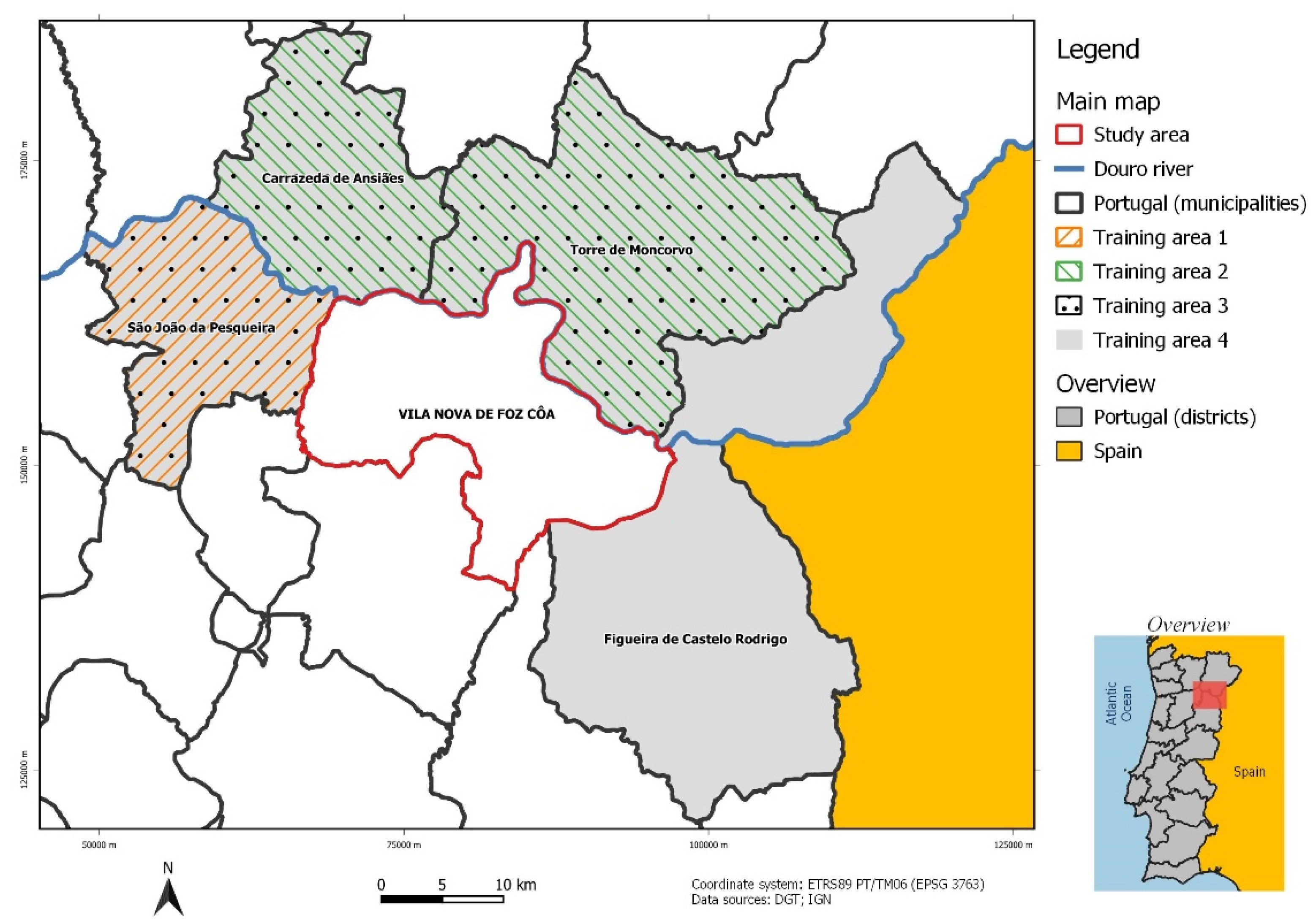
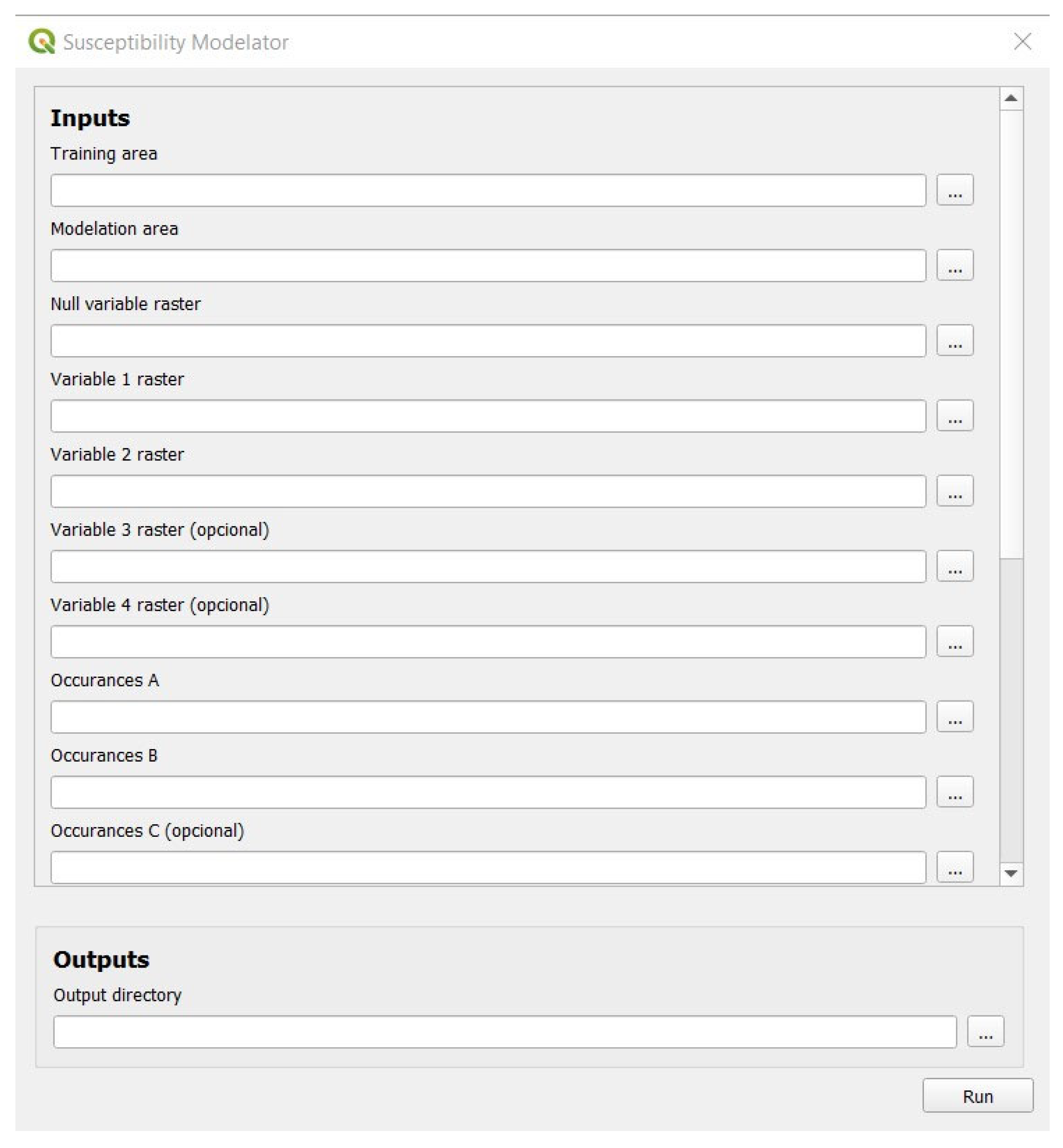
Different susceptibility models were generated by variating the shapefile used as the “Training area” input in the GUI (
Figure 4). In theory, that shapefile could be a polygon with any limits insofar as it is fully covered by the raster data used as the respective occurrence inputs and environmental variable input. The same goes for the shapefile used as the “Modelation area”: this plugin can model the susceptibility of any area, as long as it is covered by both the occurrence and environmental data used.
Different susceptibility models were generated by variating the raster data just mentioned. The AUC obtained for the particular models evaluated in the results does not matter as much as the fact that it is possible to obtain such AUC and to save it, as well as the respective ROC curve graphic, for later comparison. No automatic decision algorithm was adopted for choosing the best models, mainly because the computational power required by QGIS software is substantial and programming the calculation of several models would make it excessively slow and prone to crashing, thus limiting its utility as a plugin.
The consideration of occurrence data had the logical presupposition of a single year of information being insufficient for building a good model, as well as that of decreasing utility of data with increasing age. Thus, the first model produced in that consideration involved the two earliest sets of information on risk occurrence, and the variation in the modeling was simply made by adding earlier data to the most recent data.
The consideration of environmental variables, on the contrary, involved the comparison of single variable models (achieved using a null raster as the “Variable 2 raster” input), and the variation in the number of variables used in the combination of the different variables in the double-entry
Table 11,
Table 12 and
Table 13. In order to avoid excessive combinations in a work that is supposed to design and test the performance of a tool, the variables used in combinations of three and four were limited by imposing the presence of the best individual variable in the combinations (Level 3 COS) and later by imposing the presence of the best previous combinations.
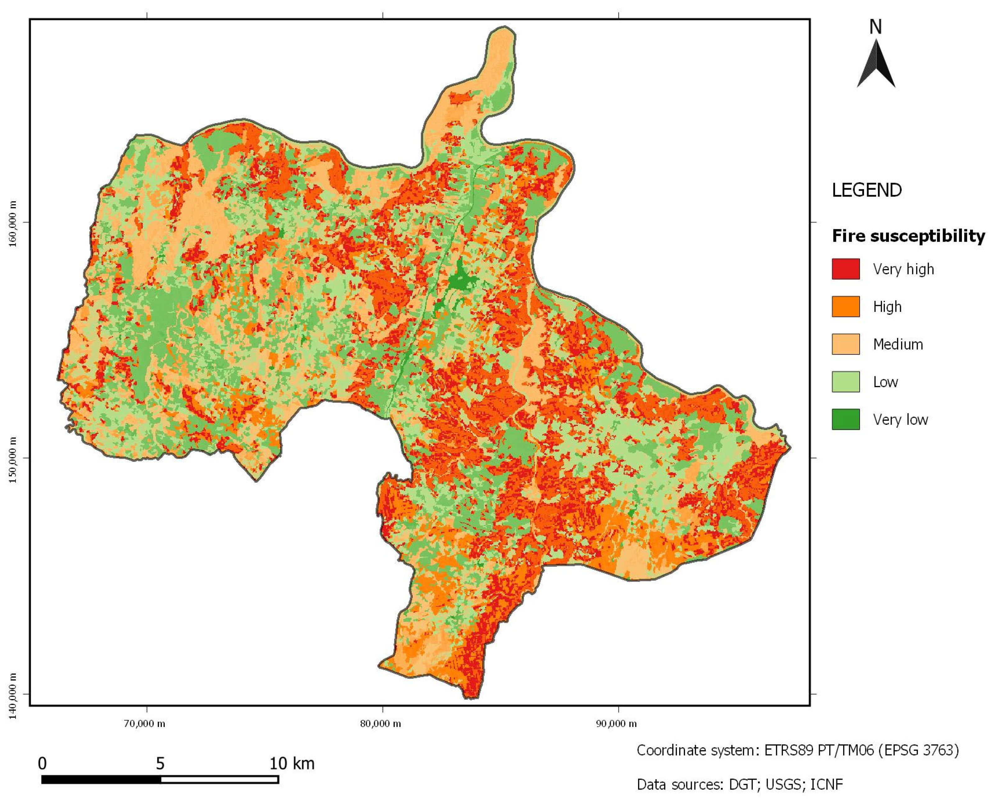
As for the results of this particular case study of wildfires in Vila Nova de Foz Côa, several points may be highlighted.
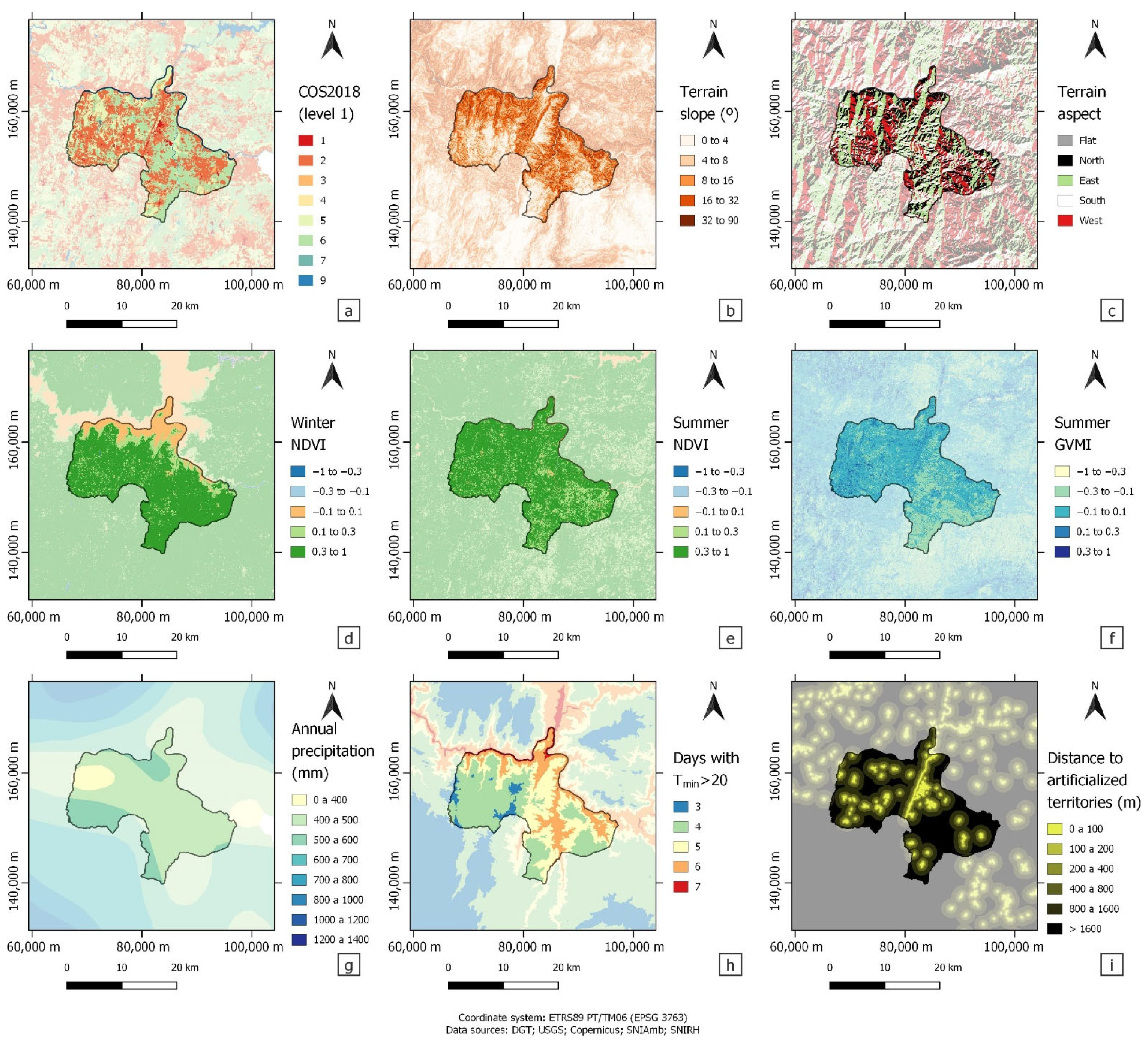
In the analysis of the susceptibility of different land use classes to fire, the sparse vegetation registered the highest score, while spontaneous grazing, agroforestry, softwood forests and shrubland were also associated with positive susceptibility values. The classes associated with artificialized territories and agriculture were invariably associated with negative scores. Previous research corroborates the results in relation to the preference of wildfires for shrubland and for softwood over hardwood [
53]. The water courses class (of COS) was surprisingly associated to high susceptibility, although it is safe to say it would be related to wildfires on the riverbank of the affluents of Douro, which are usually steep (inviting easier fire spread) and occupied by shrubland.
Susceptibility generally grows with the distance. The peak of susceptibility for slope seems to occur in the middle class (8° to 16°), although the difference between the highest and lowest scores is notably small. There were also no variations in susceptibility with respect to terrain aspect, except for the extremely low score associated with flat territory (probably related to large water surfaces and human occupation), corroborated by previous studies [
54]. In the winter season, the NDVI values revealed a peak in the susceptibility score for high values (> 0.3)—although there were no considerable variations—which is likely due to areas with a lower NDVI being associated with artificialized territories or water bodies. In the summer season, the NDVI revealed a considerable peak in susceptibility score for low values (< −0.3), but otherwise do not seem to exhibit a pattern. The moisture index in summertime points out to greater susceptibility with lower values, as expected, since dry fuel is more prone to burning. Precipitation shows a peak susceptibility value in the highest class and a noticeable minimum in the lowest class, which may be related (as with NDVI) to the highest growth of vegetable fuel during winter, where most Mediterranean precipitation occurs. As for the number of annual days with a minimum temperature above 20 °C, susceptibility shows a clear tendency to decrease with an increasing number of such days, contrary to what would be expected (perhaps due to the method used for temperature estimation, strictly related to altitude).
All training areas considered, composed by different combinations of surrounding municipalities, proved to adequately constitute study areas, although the four adjacent municipalities in the northwest were determined to be the best by a small margin. The ideal wildfire occurrence period seems to involve 6 years of information, which may be the point where there is enough information to allow the generation of a good model and a further amount of information will not improve it significantly. Where environmental variables are concerned, land use seems to be best used with level 3 specification when using the Portuguese COS classification, as it was found to be the best predictor of wildfires by far. When combining two environmental variables to generate a susceptibility map, every model that involved land use returned a prevision AUC > 70%, while no model that did not involve it has done so. When combining three environmental variables, several models returned a prevision AUC > 75%. When combining four environmental variables, six combinations returned a peak prevision AUC of 77%. These results can be verified in the light of the scale discussed in
Section 2.3.2, which would rate an AUC over 70% as good.
The use of AUC–ROC curves has been used to validate the performance of several models [
55,
56,
57]; however, to our knowledge, the methodology presented in this work was not applied in other studies to generate a fire susceptibility model, including the development of a GIS plugin, that enforces the use of the methodology implemented. There are several susceptibility fire models using different techniques and methods, but not compared to this methodology. For instance, Hong et al. (2018) [
55] used genetic algorithms (GA) to obtain the optimal combination of forest fire-related variables and apply data mining methods for constructing a forest fire susceptibility map in Dayu County (China), validating the model performance with AUC–ROC curves. Eskandari et al. (2021) [
58] also predicted the variables to be used in a model using the random forest (RF) algorithm, in Golestan Province (Iran). The use of machine learning (ML) techniques has improved the efficiency of fire prediction [
59,
60,
61]. Kalantar et al. (2020) [
56] applied adaptive regression splines (MARS), support vector machine (SVM) and boosted regression tree (BRT) to estimate fire susceptibility in Chaloos Rood (Iran), and the results were also validated using AUC–ROC curves. Zhang et al. (2019) [
62] used a deep learning algorithm, particularly the convolutional neural network (CNN), to estimate a spatial prediction model for forest fire susceptibility.
The main strength of this approach for modeling susceptibility is the flexibility it offers in adapting the models to different regions, applying the methodology to different risk types, and testing different variables in search of the best model. The main weakness would be the more simplistic approach presented for evaluating the resulting models, as it can leave out several possible scenarios and is still very time-consuming, although it was conceived to achieve quicker computational processes. There is also the threat of a lack of data, particularly in terms of the past occurrence of certain types of risk, limiting the application of this model. Furthermore, the high adaptability of this plugin means the opportunity for replacing older methodologies that use fixed environmental variables, where scores are defined at the national level, in the production of regional and local risk cartography. The results obtained in this study are mostly demonstrative of the methodology implemented in the GIS application. The selection of training areas would be different and based on their similarity both in the fire regime and in the biophysical characteristics. The presentation of a single performance indicator is not sufficiently informative, especially considering the spatial homogeneity of some of the variables used in this study. Many of the ecological processes or types of hazards are context dependent, so the training models to apply them in another context will not always give good results and this should be considered in future studies.
One of the main advantages of this work was to design a flexible tool with the potential to be applied in future works. The methodology implemented in the GIS application can be used for any study area, including several training areas, if the available dataset allows it, considering the same study area with past land use and older occurrences as a training area. More environmental variables, other than the ones experimented with, can be used in search of an optimal susceptibility model, considering that the different types of wildfires can be related to different variables, which means there should be different models built for susceptibility to small, shrubland fires and to larger, high fuel load fires. Moreover, the developed GIS plugin has a wide scope in both function and language, which means it can be applied in different contexts, other than wildfires.
Risk mapping is a crucial part of land management and land planning. The possibility of predicting which areas are susceptible to a specific type of disaster, including landslides or forest fires, is unquestioned. This work analyzed the susceptibility of different land use classes to fire. The GIS plugin developed in this study is an essential tool for land management and planning, which can be used by land use planners, foresters, wildfire risk analysts and policymakers, among others.
5. Conclusions
This work presents a new GIS application, free and open-source, for generating susceptibility models, running as a plugin under QGIS software. The developed application is capable of automatically generating susceptibility models and returning ROC curves with their respective AUC values, thus facilitating the selection of the best model for use in risk cartography.
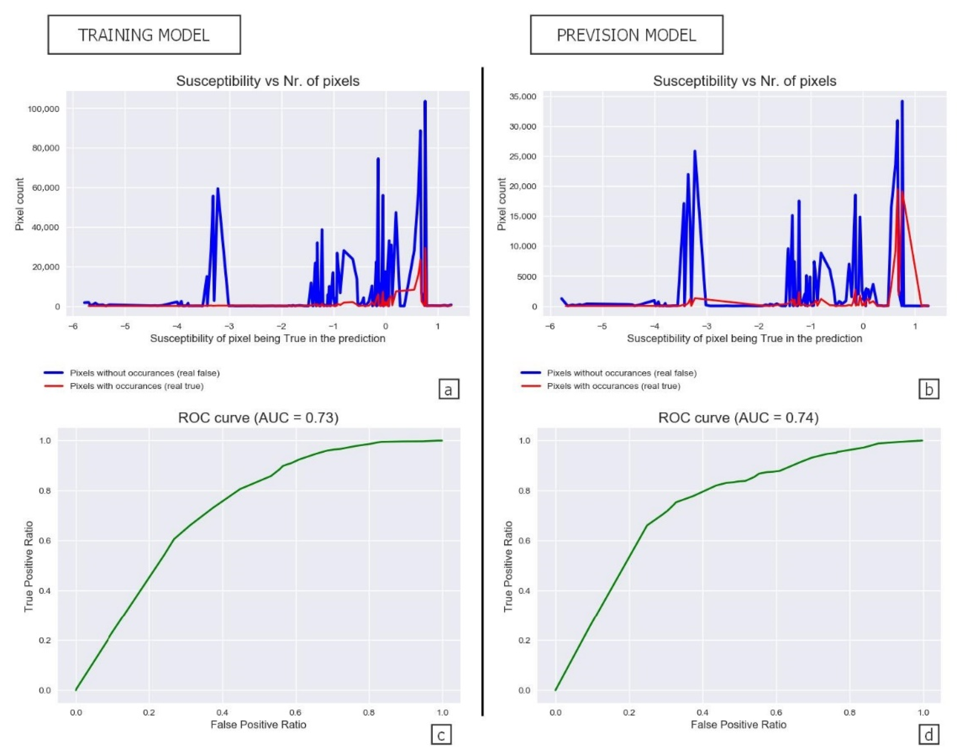
The GIS application was used for the generation of several wildfire susceptibility models in the municipality of Vila Nova de Foz Côa, Portugal, exploring different training areas, occurrence periods and environmental variables. From the results obtained, it was possible to confirm the adequacy of the environmental variables adopted by the ICNF for the calculation of wildfire susceptibility, as the model obtained with the land use and slope pair returned a prevision AUC of 74%. Nevertheless, this work does not compare this model with the one that would be obtained with the methodology used by the ICNF.
In the future, it would be interesting to compare models obtained with this methodology with models obtained with the methodology supported by official documentation. Furthermore, as this tool was designed for application in a great variety of risk cartography, such comparison should not be limited to wildfire susceptibility. Such research could prove the developed application to be useful in various contexts.


