
Geographical Data and Metadata on Land Administration in Spain

 ,
,  ,
, 
Abstract
:1. Introduction
2. Spanish Laws on Land Administration
- ●
- The land registry unit is literally described with its area, with existing elements on the ground, and the neighbours’ names at the time when deeds are prepared. This kind of land registry unit can be impossible to identify on the ground as neighbours might not be the same because of trading or inheritance. Unions or divisions might also occur with neighbour land registry units. The physical elements described in the deeds (marks, trees, walls, or fences) might also disappear with time.
- ●
- The land registry unit is linked with a cadastral parcel that has a national cadastral reference. However, the cadastral parcel boundary does not coincide with the boundary of the land registry unit, which is the physical reality. This might occur for several reasons:
- ○
- Misinterpretation of boundaries by the cadastre operator who mapped the cadastral parcel.
- ○
- The cadastral parcel shape coincides, but the cadastral cartography in the area is displaced.
- ○
- The cadastral parcel boundary coincides with the land registry unit boundary, and with the physical reality, but an area appears in the land registry unit deeds with a difference of over 10% in the cadastral parcel area. This problem triggers another legal procedure that has to be solved beforehand.
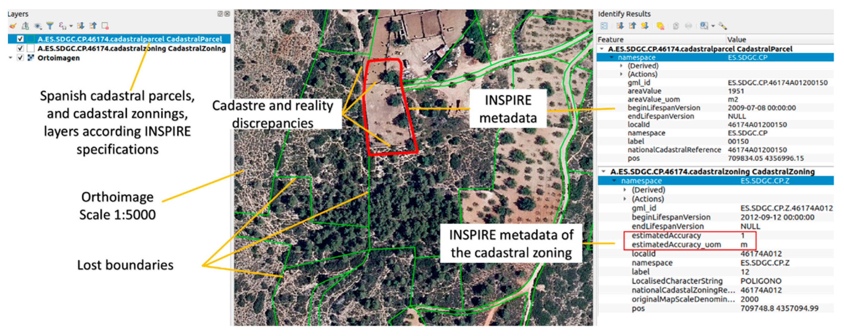
3. Cadastral Cartography in Spain
4. Spanish Cadastre—Land Registry Coordination System. Updating the Cadastral Cartography
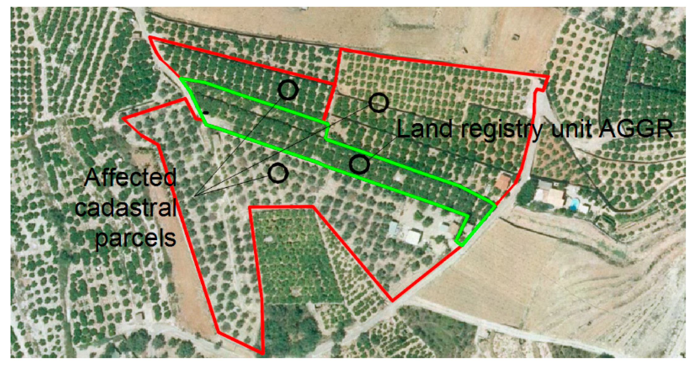
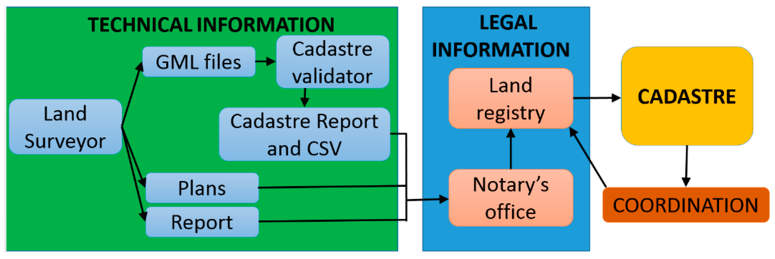
- A new land survey of the land registry unit is conducted as the cadastre does not match the reality, which is carried out by creating an AGGR. The file can be initiated voluntarily by the owner, or compulsorily for any registrations in the land registry that involve reordering terrains. The registration of an AGGR of land registry units is also compulsory the first time that they are registered.
- The technician downloads the current cadastral cartography, which comes in digital and vectorial forms, and overlaps the AGGR with the other neighbouring parcels.
- The technician modifies all the neighbouring cadastral parcels, so they adapt to the AGGR. Only the boundaries of the cadastral parcel shared with the AGGR must be modified. Figure 2 provides an example. The green lines denote the AGGR, which replace old boundaries. The red lines represent the remaining perimeter of the neighbouring boundaries that have not been amended. The outcome is the new cadastre configuration in the area where the action is taken.
- The technician creates a GML (Geographic Markup Language) file of each new cadastral parcel shape: the delimited one and the affected ones. The GML file must follow the specification of the Cadastral Parcel theme in Annexe I of INSPIRE, referred to henceforth as GML.
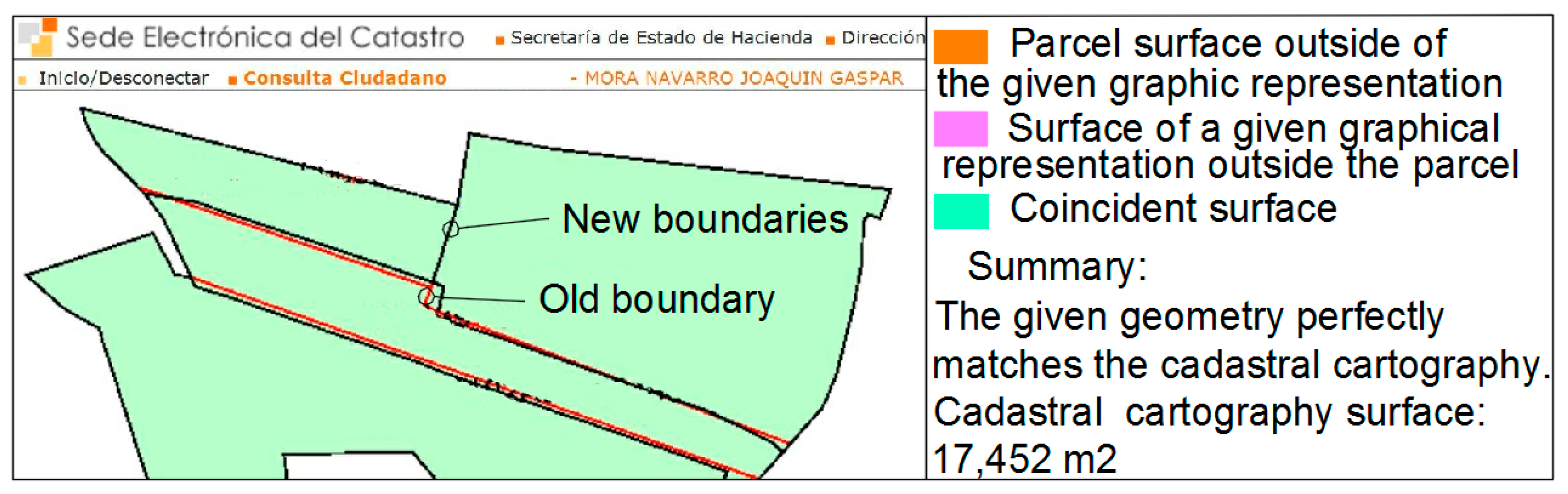
- The technician accesses the cadastre’s website in the validation system and uploads the GML files. The technician’s identity has to be accredited by, for instance, a digital certificate. The validation system issues a report that either confirms or denies whether it is possible to make the necessary changes in parcels to reflect the new reality. Figure 3 shows part of the report of the example offered in the Figure 2.

- The cadastre’s validation system also generates a code, known as the Secure Validation Code (referred to henceforth as the SVC), which enables anyone who knows this code to retrieve the report. The usefulness of the SVC is that notaries and land registrars can access the validation report, the geometry of the AGGR in the GML format, and the list of coordinates of survey points.
- Interested users only need to know the SVC to go to a notary or land registry to conduct business.
- The notary or land registrar makes the necessary legal verifications that (s)he considers suitable by producing a newly written document that must be registered in the land registry.
- Both notary and land registrar must provide the cadastre with any resulting legal information so that the cadastre can actually change geometries.
- The parcel’s new geometry is registered in the land registry as an AGGR.
- If the validation report and legal information in the land registry are correct, the cadastre must change the geometries during a maximum 5-day period, as set out in Law 13/2015.
- The cadastre notifies the land registry that the cadastral parcel has been coordinated with the land registry unit. The land registry unit is now considered coordinated.
- Registry-related attestation is applied not only to register legal information, but also to the parcel’s perimeter, whose coordinates can be obtained from the cadastre at no charge.
- The descriptive and graphical cadastral certifications of coordinated cadastral parcels show that the parcel status is coordinated.
- Guarantees technicians that their delimitation is geometrically correct
- Guarantees notaries and land registrars that, if they attach correct legal information, updating shall be completed in 5 days after submitting legal information. Therefore, real-state trade does not stop.
- Reduces the editing workload performed in cadastre offices and transmits it to free-profession technicians. The free-profession technicians draw the new parcel configurations in each updating.
- ●
- Qualitative component:
- ○
- Statement: Boundary determination of the land registry unit X, corresponding with the cadastral parcel Y, according to what is written in the deeds. The cadastral map does not coincide with reality and needs to be updated. No neighbours were present during the survey. To take the measurements, a GPS was used. The standard deviation of the coordinates obtained is, according to the public RTK corrections service, better or equal to 5 cm. The final area of the land registry unit is Z m2, 8% bigger than the area that appears in the deeds, A m2.
- ○
- Process step:
- ▪
- Step 1: Northern and eastern boundary measurement. They are well-established on the ground by a wall that belongs to the land registry unit, so they have been measured by the outside side. The worst standard deviation in the points of this boundary, according to the RTK corrections service, is 0.05 m. The maximum error (99% probability) in these boundary points is 0.125 m.
- ▪
- Step 2: Southeast boundary measurement. It is an embankment, between 2 to 4 m wide. According to local custom, 2/3 of the embankment belongs to the upper land registry unit. Therefore, 2/3 of this embankment has been given to the land registry unit object of this survey, because it is over the neighbouring property. To find this boundary, the upper and lower embankment limits have been measured. A computer aid design program has been used to draw the embankment limits and to interpolate the 2/3 parts of width. A boundary point has been interpolated each 2 m. The limits of the embankment were not clear. We estimate a strip of land uncertainty of 0.5 m in the embankment limits. Due to that, we estimate that the maximum error in this boundary is 0.5 m.
- ▪
- Step 3: West boundary reposition. This boundary is lost and has been repositioned. The coordinates of this boundary have been obtained by georeferencing an old cadastral map, made in 1942, at a scale of 1/5000. This map is available in the Historical Map Archive of Alicante. The georeferencing control point’s standard deviation was 1 m. This boundary’s maximum error (99% probability) is 2.5 m.
- ○
- Source: For the boundary determination of this land registry unit, the following sources have been used:
- ▪
- Old cadastral map, made in 1942, scale 1/5000, available in the Historical Map Archive of Alicante.
- ▪
- Current cadastral maps and current aerial national orthophotography.
- ▪
- Land registry unit deeds.
- ●
- Quantitative component:
- ○
- Name of measure: Absolute External Positional Accuracy.
- ○
- Measure description: Coordinate maximum error, in the coordinate system of the boundary coordinates, of the land registry unit.
- ○
- Result:
- ▪
- Value unit: m.
- ▪
- Value: 2.5.
- More transparency in the conditions of the coordinates of each boundary can help neighbours reach agreements in a notary or land registry office.
- This metadata will help land surveyors delimit adjacent land registry units.
- This metadata will help solve possible future disputes between neighbours when another solution for one boundary appears. In these cases, it will be possible to compare the techniques used and see if both solutions are compatible or not. No exact solution exists, and despite two boundaries being different, they can be not contradictory. Metadata will allow determining which is the best solution.
5. Methodology
6. Prototype to Manage Data and Metadata of Land Registry Unit Delimitations. TopoDelProp
- ●
- User: each work delimitation is associated with the user who creates it in the system. Personal data are saved.
- ●
- Data of the surveying: the descriptive general data of the delimitation work are saved.
- ●
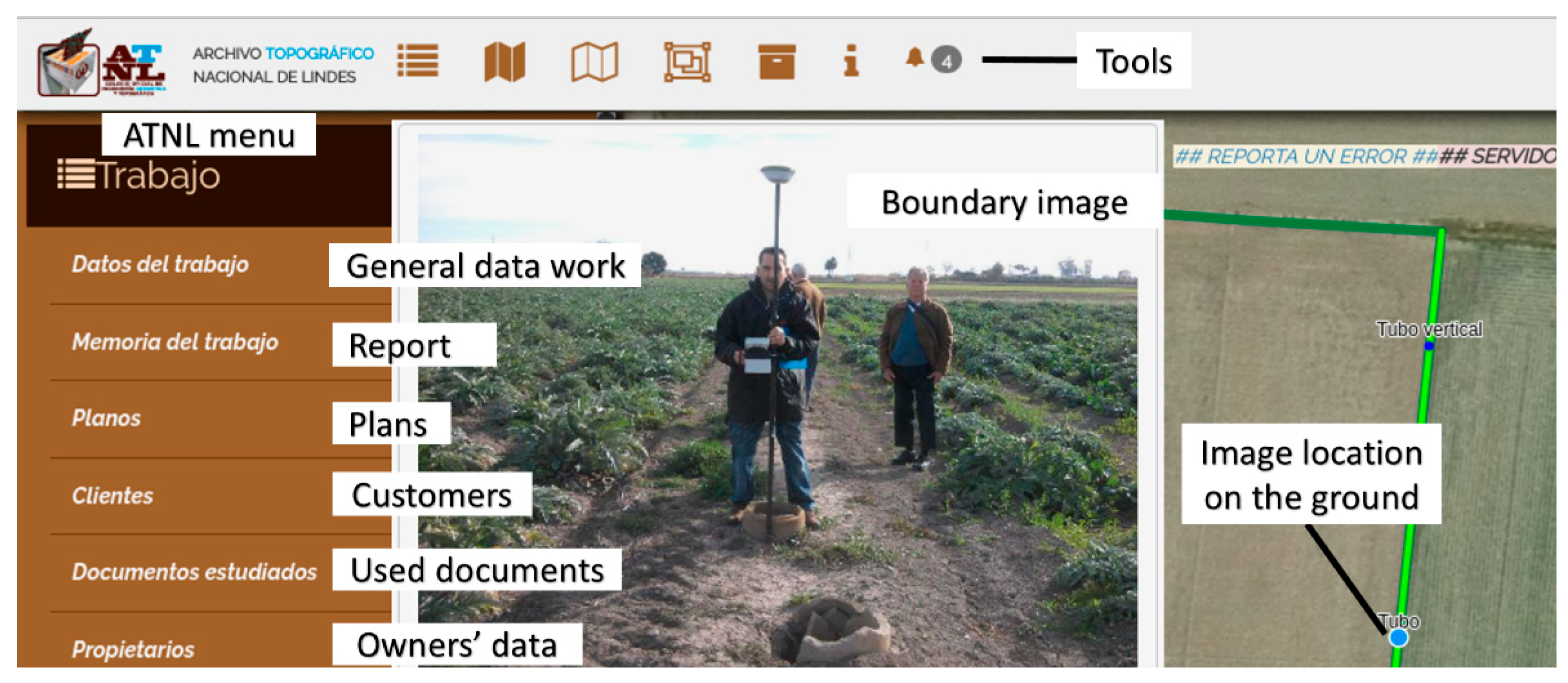
- Surveying report: this is a PDF document with non-regulated content used to explain the surveying work, for instance, describing the problem to be solved, equipment used, documents used to solve the work, decisions made, accuracy achieved, process steps, etc.
- ●
- Map: intermediate maps created to solve the delimitation, and the map solution. The number of maps is limitless.
- ●
- Documents used: the documents studied to solve the land registry unit delimitation, such as property deeds, registrations, cadastral maps, orthophotographs, urban plannings, etc.
- ●
- Customers: each customer’s personal data and his/her scanned national ID card. The customers are the people who pay for the delimitation work.
- ●
- Owners: each owner’s personal data and his/her scanned national ID card.
- ●
- Neighbours: each neighbour’s personal data and his/her scanned national ID card.
- ●
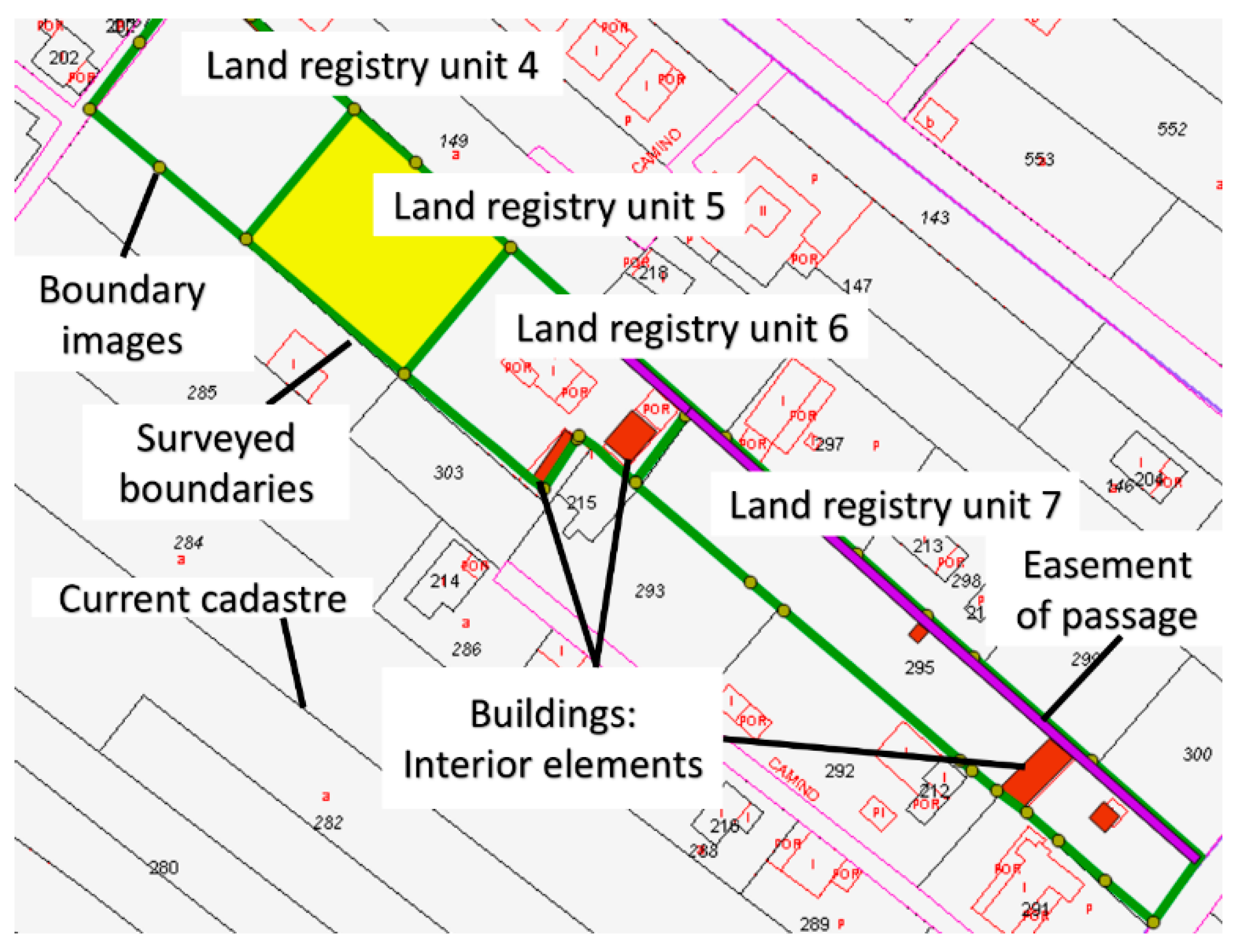
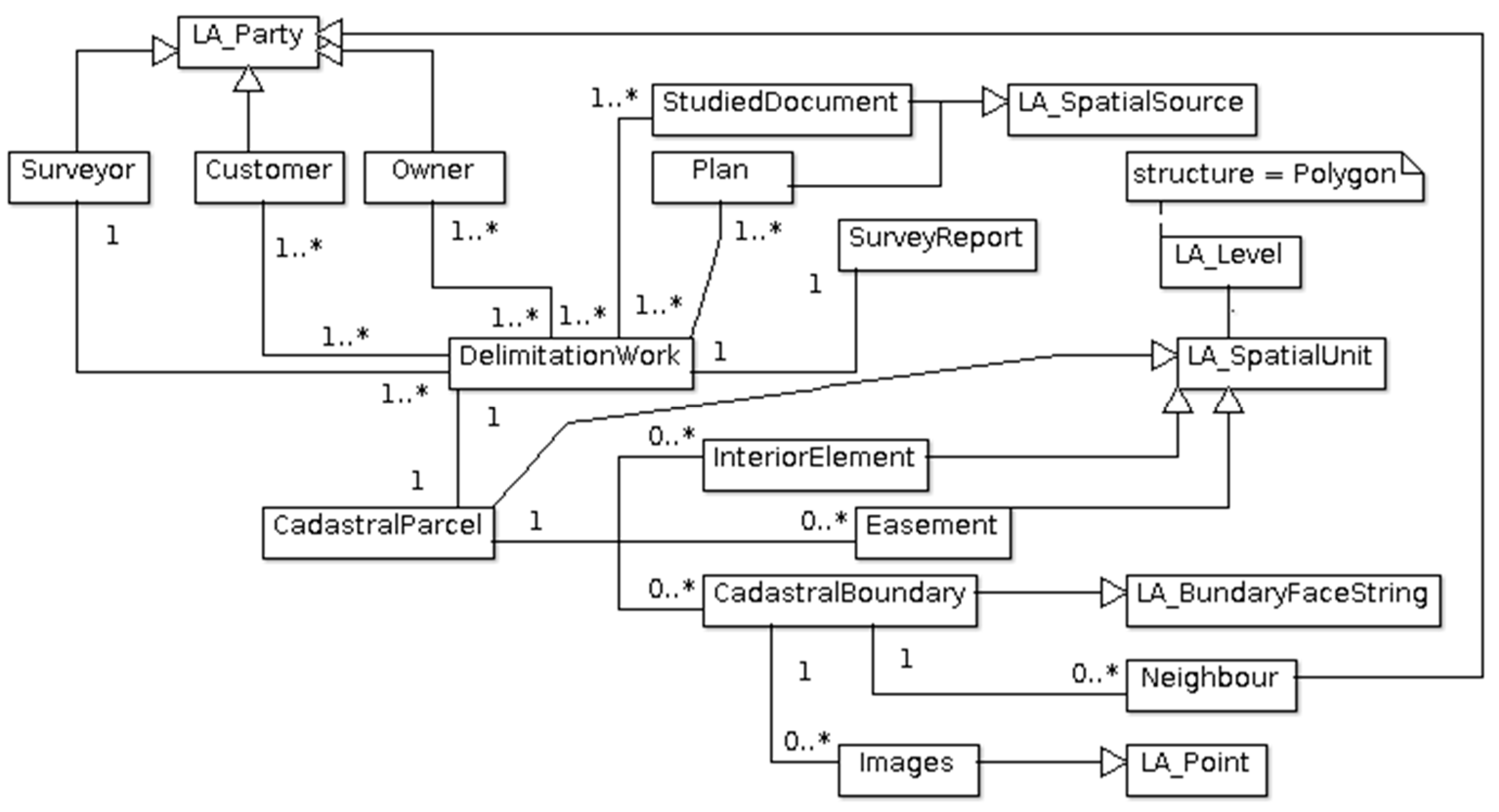
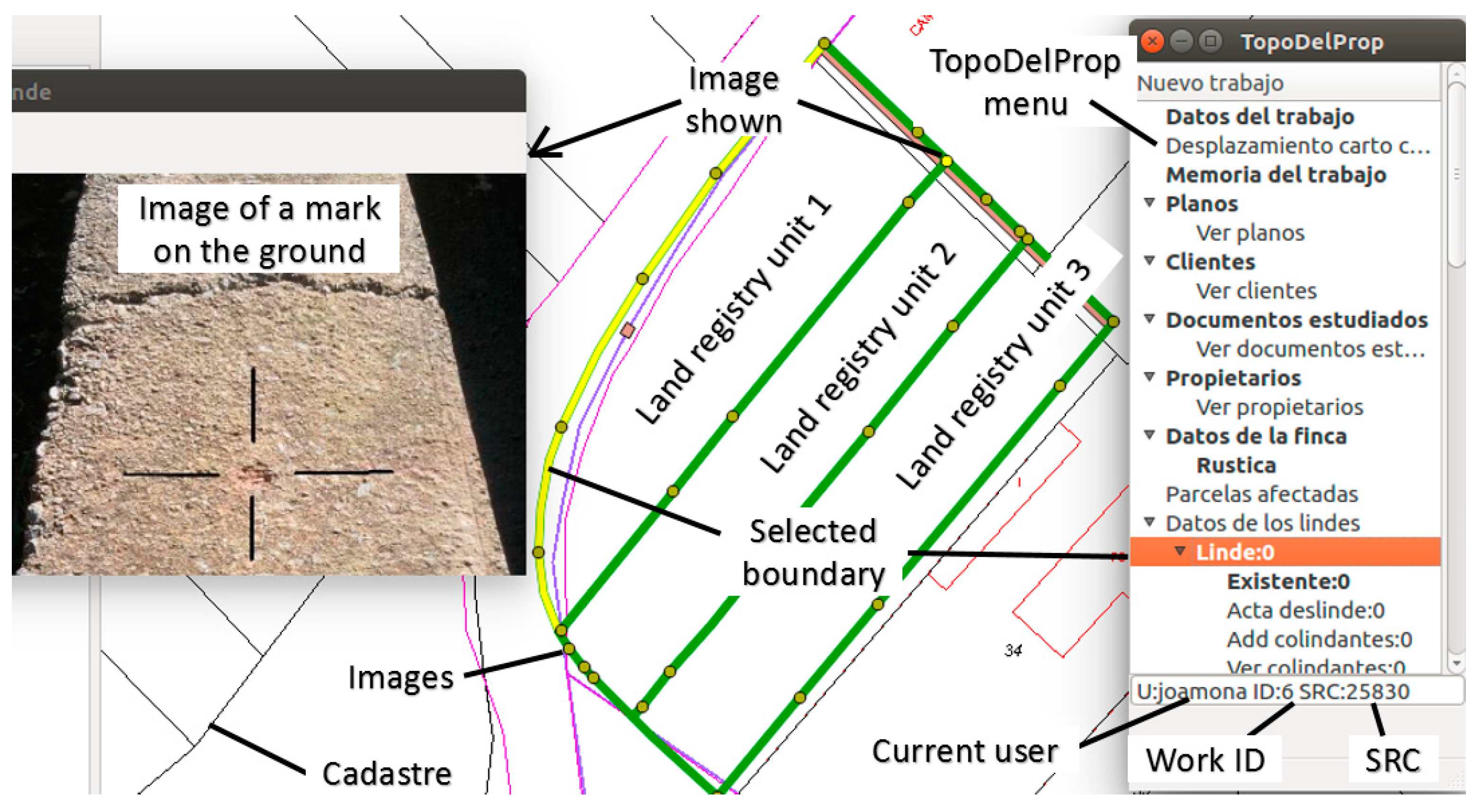
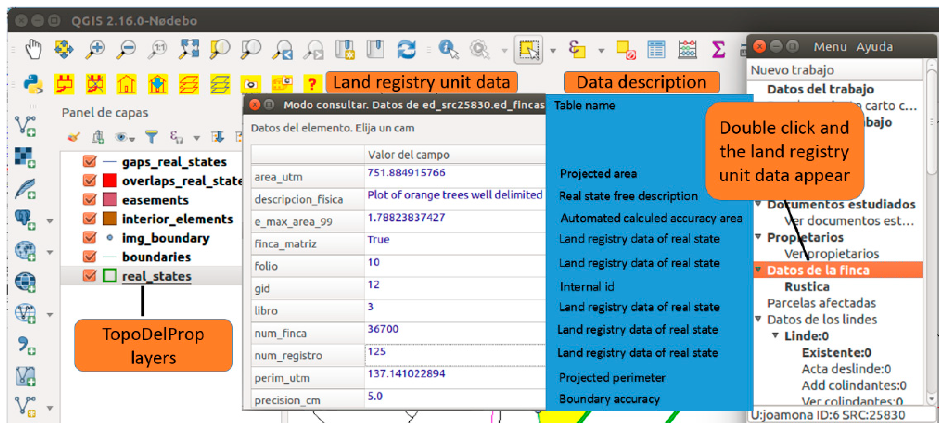
- Land registry units: surface elements. This defines the geometry of the land registry unit and its descriptive data. Each land registry unit, which can be composed of several polygons, is associated with a single delimitation work.
- ●
- Boundaries: Independent linear elements for each neighbour. Boundaries are the most important elements of the database and require the most metadata, as boundaries are the element that limit the property/parcel. Therefore, they define up to what point owners’ rights reach. Boundaries have general metadata, which are saved along with their geometry, and, depending on the boundary type, they may have some specific data. Boundaries are classified into four types:
- ○
- Boundaries that are well-distinguished on the ground and can be measured. In this case, the existing physical element on the ground can be described.
- ○
- Boundaries that are not well-distinguished on the ground and have to be repositioned. In this case, the method followed to obtain the coordinates is described, normally performed by using different cartographies.
- ○
- Boundaries that are not well-distinguished on the ground because they form part of a design plan, e.g., urban planning, or parcels of replotting.
- ○
- Boundaries that have been determined without making a visit to the field, and have been digitalised on an orthophotograph, for example.
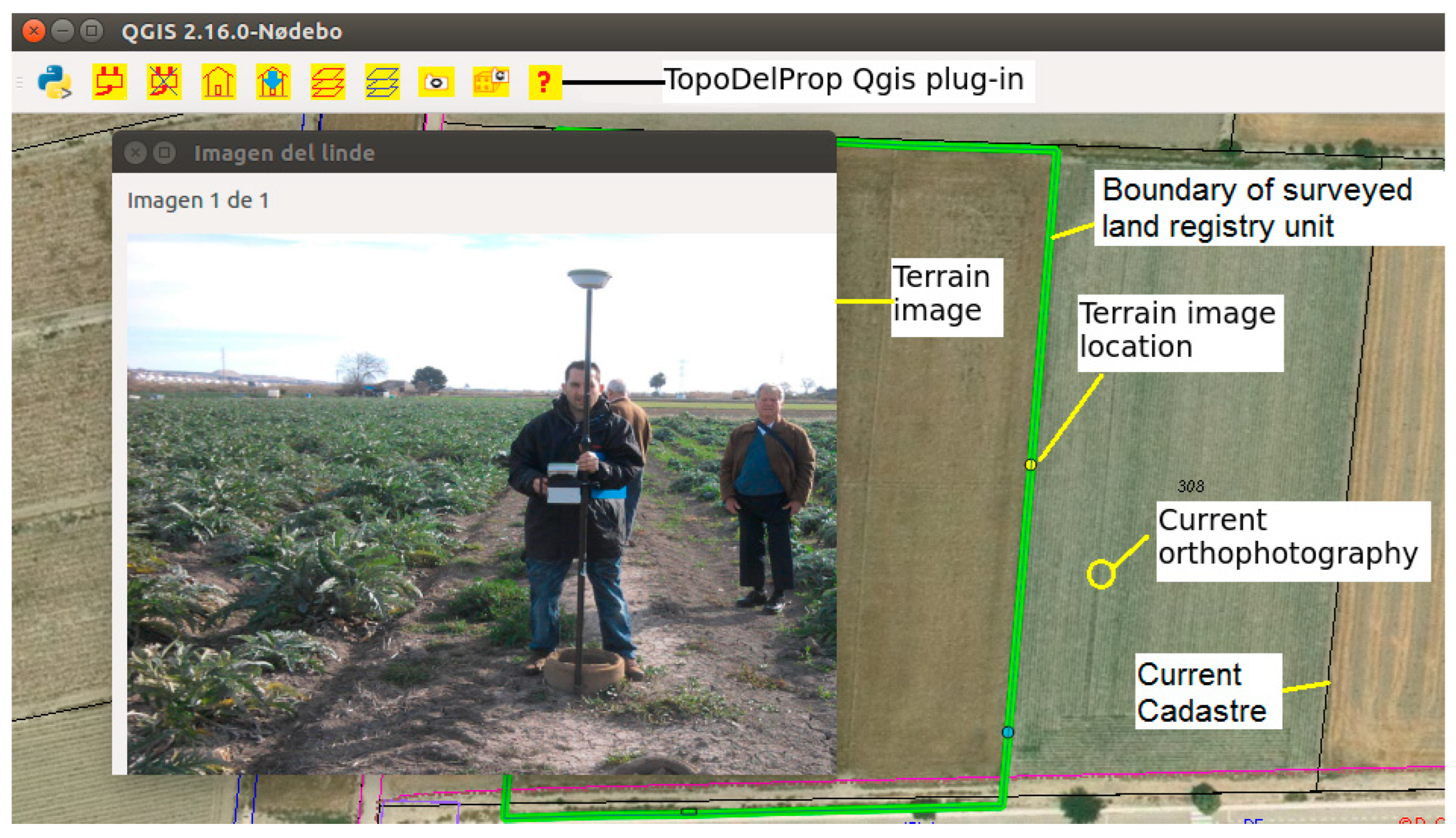
- Images: they are sporadic elements that indicate the position of an image taken when measuring a boundary. Their usefulness lies in helping us to understand where the boundary is delimited (Figure 9). Data from that point are saved as one image per point. Images are associated with a boundary.
- Interior elements: they are surface elements that fall within a land registry unit: buildings, swimming pools, etc. An indefinite number of images can be associated with each interior element which, in turn, is associated with a land registry unit.
- Easements: if a land registry unit has easements and can be delimited by a closed polygon, it can be measured, drawn and added to the database. Each easement is associated with a land registry unit.
- Data of the people who intervene in the delimitation work: land surveyors, owners, customers and neighbours, which correspond to instances of the LA_Party class.
- The delimitation work report and maps that correspond to the LA_SpatialSource class.
- The documents used for conducting the delimitation work correspond to LA_SpatialSource classe.
- The parcel delimited in the delimitation work corresponds to the LA_SpatialUnit class.
- Boundaries correspond to the LA_BoundaryFaceString class.
- Images of boundaries are sporadic elements associated with a boundary and correspond to the LA_Point class.
- Interior elements and easements correspond to the LA_SpatialUnit class.
- Lack of resources and the complexity of the developing software. For example, topology geometry checks require projected coordinate systems to be able to calculate overlaps and intersections between geometries. In Spain, four zones of UTM projection are used. This usually means duplicating the geometry tables four time to store each geometry in the corresponding zone. This also implies choosing, for each municipality in the UTM zone borders, in which zone to store the land registry unit geometries. To avoid this problem and to have continuous cartography in large areas, the geometry coordinates should be stored in ellipsoidal coordinates. Topological checks on the ellipsoid surface are usually performed by projecting the geometries locally to obtain flat coordinates, or by assuming some approximations, therefore finding important deviations in calculations, that usually users are unaware of [58].
- Introducing the information in TopoDelProp system takes one or two hours for a trained user, producing an extra cost. This is because the land surveyor must manually create the geometries as topologically correct, not only internally with the delimitation geometries, but with the existing geometries in the database. This means that it is necessary to download the existing geometries in the database and to adapt the new geometries to the existing geometries. This process is not easy and needs voluntary training and time.
7. Discussion
Author Contributions
Funding
Institutional Review Board Statement
Informed Consent Statement
Data Availability Statement
Conflicts of Interest
References
- Bennett, R.; Tambuwala, N.; Rajabifard, A.; Wallace, J.; Williamson, I. On recognizing land administration as critical, public good infrastructure. Land Use Policy 2013, 30, 84–93. [Google Scholar] [CrossRef]
- Griffith-Charles, C.; Sutherland, M. Analysing the costs and benefits of 3D cadastres with reference to Trinidad and Tobago. Comput. Environ. Urban Syst. 2013, 40, 24–33. [Google Scholar] [CrossRef]
- Williamson, I.; Enemark, S.; Wallace, J.; Rajabifard, A. Land Administration for Sustainable Development; ESRI Press Academic: Redlands, CA, USA, 2010; ISBN 978-1-58948-041-4. [Google Scholar]
- Navratil, G.; Andrew, U. Frank’s impact on research in land administration. Int. J. Geogr. Inf. Sci. 2018, 32, 2501–2513. [Google Scholar] [CrossRef] [Green Version]
- De Soto, H. El Misterio del Capital; Planeta: Barcelona, Spain, 2000; ISBN 978-612-319-437-6. [Google Scholar]
- Berné Valero, J.L.; Femenia-Ribera, C.; Benítez Aguado, E. Catastro en España; Universitat Politècnica de València: Valencia, Spain, 2008; ISBN 978-84-8363-242-0. [Google Scholar]
- Bydłosz, J. The application of the Land Administration Domain Model in building a country profile for the Polish cadastre. Land Use Policy 2015, 49, 598–605. [Google Scholar] [CrossRef]
- Castanyer, J. Marco administrativo: Sistemas de administración de la tierra en Europa (MOLA). Panorama de los catastros europeos. CT Catastro 1997, 31, 79–92. [Google Scholar]
- Van der Molen, P. The dynamic aspect of land administration: An often-forgotten component in system design. Comput. Environ. Urban Syst. 2002, 26, 361–381. [Google Scholar] [CrossRef]
- Pullar, D.; Donaldson, S. Accuracy issues for spatial update of digital cadastral maps. ISPRS Int. J. Geo-Inf. 2022, 11, 221. [Google Scholar] [CrossRef]
- Kaufmann, J.; Steudler, D. Cadastre 2014: A vision for a future cadastral systems. In Proceedings of the FIG XXI International Congress, Brighton, UK, 19–25 July 1998; p. 44. [Google Scholar]
- Döner, F.; Thompson, R.; Stoter, J.; Lemmen, C.; Ploeger, H.; van Oosterom, P.; Zlatanova, S. 4D cadastres: First analysis of legal, organizational, and technical impact—With a case study on utility networks. Land Use Policy 2010, 27, 1068–1081. [Google Scholar] [CrossRef]
- Döner, F.; Thompson, R.; Stoter, J.; Lemmen, C.; Ploeger, H.; van Oosterom, P.; Zlatanova, S. Solutions for 4D cadastre—With a case study on utility networks. Int. J. Geogr. Inf. Sci. 2011, 25, 1173–1189. [Google Scholar] [CrossRef]
- Lemmen, C.; Van Oosterom, P.; Bennett, R. The Land Administration Domain Model. Land Use Policy 2015, 49, 535–545. [Google Scholar] [CrossRef] [Green Version]
- Kalantari, M.; Dinsmore, K.; Urban-Karr, J.; Rajabifard, A. A roadmap to adopt the Land Administration Domain Model in cadastral information systems. Land Use Policy 2015, 49, 552–564. [Google Scholar] [CrossRef]
- Gogolou, C.; Dimopoulou, E. Land administration standardization for the integration of cultural heritage in land use policies. Land Use Policy 2015, 49, 617–625. [Google Scholar] [CrossRef]
- Góźdź, K.J.; van Oosterom, P.J.M. Developing the information infrastructure based on LADM—The case of Poland. Surv. Rev. 2016, 48, 168–180. [Google Scholar] [CrossRef] [Green Version]
- Mader, M.; Matijević, H.; Roić, M. Analysis of possibilities for linking land registers and other official registers in the Republic of Croatia based on LADM. Land Use Policy 2015, 49, 606–616. [Google Scholar] [CrossRef] [Green Version]
- Paixao, S.; Hespanha, J.P.; Ghawana, T.; Carneiro, A.F.T.; Zevenbergen, J.; Frederico, L.N. Modeling indigenous tribes’ land rights with ISO 19152 LADM: A case from Brazil. Land Use Policy 2015, 49, 587–597. [Google Scholar] [CrossRef]
- Zulkifli, N.A.; Abdul Rahman, A.; van Oosterom, P.; Tan, L.C.; Jamil, H.; Teng, C.H.; Looi, K.S.; Chan, K.L. The importance of Malaysian Land Administration Domain Model country profile in land policy. Land Use Policy 2015, 49, 649–659. [Google Scholar] [CrossRef]
- Adeniyi, P.O.; Akingbade, A.; Akande, A. Solutions for Open Land Administration (SOLA) software—customizing open source software to support the systematic land titling registration pilot project in Ondo State, Nigeria. In Proceedings of the 2015 World Bank Conference on Land and Poverty, Washington, DC, USA, 23–27 March 2015; p. 35. [Google Scholar]
- Velasco Martín-Vares, A. La norma ISO TC 2011 19 152, sobre el Modelo Catastral. Land Administration Domain Model (LADM). CT Catastro 2016, 87, 7–33. [Google Scholar]
- Sánchez-Maganto, A.; Rodríguez Pascual, A.F.; Abad Power, P.; López Romero, E. El Núcleo Español de Metadatos, perfil mínimo recomendado de metadatos para España. In Proceedings of the II Jornadas Técnicas de la IDE de España (JIDEE2005), Madrid, Spain, 24 November 2005; pp. 1–11. [Google Scholar]
- ICSM Cadastre 2034 Strategy, Powering Land and Property. Available online: https://www.icsm.gov.au/sites/default/files/Cadastre2034_0.pdf (accessed on 6 July 2022).
- Renteria-Agualimpia, W.; Lopez-Pellicer, F.J.; Lacasta, J.; Zarazaga-Soria, F.J.; Muro-Medrano, P.R. Improving the geospatial consistency of digital libraries metadata. J. Inf. Sci. 2016, 42, 507–523. [Google Scholar] [CrossRef] [Green Version]
- Di, L.; Shao, Y.; Kang, L. Implementation of Geospatial Data Provenance in a Web Service Workflow Environment With ISO 19115 and ISO 19115-2 Lineage Model. IEEE Trans. Geosci. Remote Sens. 2013, 51, 5082–5089. [Google Scholar] [CrossRef]
- Enemark, S.; Mclaren, R.; Lemmen, C. Fit-for-Purpose Land Administration-providing secure land rights at scale. Land 2021, 10, 972. [Google Scholar] [CrossRef]
- McLaren, R. How Big Is Global Insecurity of Tenure? Available online: https://www.gim-international.com/content/article/how-big-is-global-insecurity-of-tenure (accessed on 13 July 2022).
- Todorovski, D.; Salazar, R.; Jacome, G.; Mclaren, R.; Lemmen, C. Assessment of land administration in Ecuador based on the Fit-for-Purpose approach. Land 2021, 10, 862. [Google Scholar] [CrossRef]
- Balas, M.; Carrilho, J.; Lemmen, C. The Fit for Purpose Land Administration approach-connecting people, processes and technology in Mozambique. Land 2021, 8, 818. [Google Scholar] [CrossRef]
- Shankar Panday, U.; Chhatkuli, R.; Joshi, J.R.; Deuja, J.; Antonio, D.; Enemark, S. Securing land rights for all through Fit-for-Purpose Land Administration approach: The case of Nepal. Land 2021, 10, 744. [Google Scholar] [CrossRef]
- Chigbu, U.E.; Bendzko, T.; Mabakeng, M.R.; Kuusaana, E.D.; Tutu, D.O. Fit-for-purpose land administration from theory to practice: Three demonstrative case studies of local land administration initiatives in Africa. Land 2021, 10, 476. [Google Scholar] [CrossRef]
- Fandos Pons, P. El Sistema de información geográfica registral español. In Proceedings of the III Conferencia y Asamblea de la Red Interamericana de Catastro y Registro de la Propiedad, Montevideo, Uruguay, 14–17 November 2017. [Google Scholar]
- Alonso Peña, C. Productos y servicios sobre estándares internacionales (INSPIRE): Aceptación y uso en el tráfico inmobiliario. In Proceedings of the III Conferencia y Asamblea de la Red Interamericana de Catastro y Registro de la Propiedad, Montevideo, Uruguay, 14–17 November 2017. [Google Scholar]
- Velasco Martín-Vares, A. Smart successful cadastral new tools for real estate registration: “all in 16 digits”. In Proceedings of the Joint PCC & EULIS Conference. The Current Technological Trends in Land Registration, Vittoriosa, Malta, 5 May 2017. [Google Scholar]
- Velasco Martín-Vares, A.; Alonso Peña, C.; Virgos, L.; Serrano, F. Inspire services of the Spanish Directorate General for Cadastre and its use to resolve an old problem of coordination between Spanish Cadastre and Land Registry. In Proceedings of the INSPIRE Conference 2016, Barcelona, Spain, 11–15 September 2016. [Google Scholar]
- Velasco Martín-Vares, A. The “back office” of the Spanish cadastre that makes possible the interaction with partners. In Proceedings of the Conference of PCC, EuroGeographics-Cadastre and Land Registry KEN and EULIS, Bratislava, Slovakia, 17–18 November 2016. [Google Scholar]
- Spanish General Directorate for Cadastre. EuroGeographics Increasing legal certainty and transparency in Spain. In EuroGeographics Annual Review; Spanish General Directorate for Cadastre: Madrid, Spain, 2015; p. 44. [Google Scholar]
- Femenia-Ribera, C. Caso de estudio en España. Ley 13/2015 sobre coordinación Catastro-Registro. In Proceedings of the FIG Commisision 7 and 9 Annual Conference and Meeting, Cartagena de Indias, Colombia, 4–8 December 2017. [Google Scholar]
- Velasco Martín-Vares, A.; Alonso Peña, C. Smart cadastral tools for real estate registration. GIM Int. 2017, 31, 33–35. [Google Scholar]
- Alonso Peña, C.; Blanco Urzaiz, J. La función del Registro de la Propiedad y la función del Catastro. In Proceedings of the Agencia Española de Cooperación Internacional para el Desarrollo (AECID), Cartagena de Indias, Colombia, 15–18 November 2016. [Google Scholar]
- Blanco-Urzáiz, J. La coordinación entre el Registro de la Propiedad y el Catastro Inmobiliario tras la Ley 13/2015 en España. In Proceedings of the II Reunión y Conferencia de la Red Interamericanca de Catastro y Registro de la Propiedad, Ciudad de Panamá, Panamá, 27 September 2016. [Google Scholar]
- Blanco-Urzáiz, J. The coordination between the Property Registry and the Cadastre in the aftermath of Law 13/2015 in Spain. In Proceedings of the UNECE WPLA Workshop: State and Market: Cadastres and Property Rights Registries, Madrid, Spain, 24–25 November 2016. [Google Scholar]
- Fandos Pons, P.; Alonso Peña, C. The Spanish cadastre and property rights: A smart model of coordinated interaction. In Proceedings of the Common Vision Conference 2016, Amsterdam, The Netherlands, 5–7 June 2016; pp. 1–18. [Google Scholar]
- Velasco Martín-Vares, A. Spanish Cadastre: Collaborative maintenance and dissemination. In Proceedings of the Meeting of the Permanent Committee on Cadastre in the European Union, Rome, Italy, 20–21 November 2014. [Google Scholar]
- Velasco Martín-Vares, A. Política y resultados del catastro abierto español. In Proceedings of the II Reunión y Conferencia de la Red Interamericana de Catastro y Registro de la Propiedad, Ciudad de Panamá, Panamá, 27–30 September 2016. [Google Scholar]
- Jiménez-Clar, A. Perfiles de la coordinación de la información territorial gráfica, en la Ley 13/2015, de 24 de junio, de reforma de la Ley Hipotecaria y de la Ley de Catastro Inmobiliario. CT Catastro 2016, 64, 27–50. [Google Scholar]
- Gómez Gálligo, J. Grandes expectativas derivadas de la Ley 13/2015, de 24 de junio en relación a la coordinación del Registro de la Propiedad y del Catastro. CT Catastro 2015, 84, 13–26. [Google Scholar]
- Trystuła, A.; Dudzí Nska, M.; Ryszard´zróbek, R.R. Evaluation of the Completeness of Spatial Data Infrastructure in the Context of Cadastral Data Sharing. Land 2020, 9, 272. [Google Scholar] [CrossRef]
- Berné Valero, J.L.; Femenia-Ribera, C. Catastro de Rústica; Universitat Politècnica de València: Valencia, Spain, 2000; ISBN 84-7721-941-9. [Google Scholar]
- Femenia-Ribera, C.; Mora-Navarro, G.; Pérez, L.J.S. Evaluating the use of old cadastral maps. Land Use Policy 2022, 114, 105984. [Google Scholar] [CrossRef]
- Thompson, R.J. A model for the creation and progressive improvement of a digitalcadastral data base. Land Use Policy 2015, 49, 565–576. [Google Scholar] [CrossRef]
- Vranić, S.; Matijević, H.; Roić, M. Modelling outsourceable transactions on polygon-based cadastral parcels. Int. J. Geogr. Inf. Sci. 2015, 29, 454–474. [Google Scholar] [CrossRef]
- Femenia-Ribera, C.; Mora-Navarro, G.; Benítez-Aguado, E.; Garrido-Villén, N. Estudio y análisis de la representación de la línea límite de término municipal según diversas cartografías en la albufera de Valencia. Scr. Nova. Rev. Electrónica Geogr. Y Cienc. Soc. 2013, 17, 448. [Google Scholar]
- Olfat, H.; Shojaei, D.; Briffa, M.; Maley, S.; Rajabifard, A. Strategic actions for increasing the submission of digital cadastral data by the surveying industry based on lessons learned from Victoria, Australia. ISPRS Int. J. Geo-Inf. 2018, 7, 47. [Google Scholar] [CrossRef] [Green Version]
- Shojaei, D.; Olfat, H.; Rajabifard, A.; Darvill, A.; Briffa, M. Assessment of the Australian digital cadastre protocol (ePlan) in terms of supporting 3D building subdivisions. Land Use Policy 2016, 56, 112–124. [Google Scholar] [CrossRef]
- Kalogianni, E.; Dimopoulou, E.; Quak, W.; Germann, M.; Jenni, L.; van Oosterom, P. INTERLIS language for modelling legal 3D spaces and physical 3D objects by including formalized implementable constraints and meaningful code lists. ISPRS Int. J. Geo-Inf. 2017, 6, 319. [Google Scholar] [CrossRef] [Green Version]
- Martínez-Llario, J.; Baselga, S.; Coll, E. Accurate algorithms for spatial operations on the spheroid in a spatial database management system. Appl. Sci. 2021, 11, 5129. [Google Scholar] [CrossRef]


Publisher’s Note: MDPI stays neutral with regard to jurisdictional claims in published maps and institutional affiliations. |
© 2022 by the authors. Licensee MDPI, Basel, Switzerland. This article is an open access article distributed under the terms and conditions of the Creative Commons Attribution (CC BY) license (https://creativecommons.org/licenses/by/4.0/).
Share and Cite
Mora-Navarro, G.; Femenia-Ribera, C.; Velilla Torres, J.M.; Martinez-Llario, J. Geographical Data and Metadata on Land Administration in Spain. Land 2022, 11, 1107. https://doi.org/10.3390/land11071107
Mora-Navarro G, Femenia-Ribera C, Velilla Torres JM, Martinez-Llario J. Geographical Data and Metadata on Land Administration in Spain. Land. 2022; 11(7):1107. https://doi.org/10.3390/land11071107
Chicago/Turabian StyleMora-Navarro, Gaspar, Carmen Femenia-Ribera, Joan Manuel Velilla Torres, and Jose Martinez-Llario. 2022. "Geographical Data and Metadata on Land Administration in Spain" Land 11, no. 7: 1107. https://doi.org/10.3390/land11071107
APA StyleMora-Navarro, G., Femenia-Ribera, C., Velilla Torres, J. M., & Martinez-Llario, J. (2022). Geographical Data and Metadata on Land Administration in Spain. Land, 11(7), 1107. https://doi.org/10.3390/land11071107