1. Introduction
The Legal and Political Frameworks for SGI in the European Union and Its Member State Germany
Territorial cohesion is a key policy concept of the European Union. It aims at the reduction of disparities between the levels of development of the various regions and the backwardness of the least favoured regions [
1] and is therefore closely related to the provision of SGI that are imperative for economic and social well-being [
2,
3].
SGIs “are services that public authorities of the Member States classify as being of general interest and, therefore, subject to specific public service obligations (PSO). The term covers both economic activities (…) and non-economic services” [
4] (p. 3).
Moreover, SGI should not be limited to the quality of and the access to physical infrastructure facilities only, but encompass [
5]:
Basic physiological needs (eating, drinking, sleeping, living);
Security needs (order, safety, health, protection against natural hazards);
Social needs (education, cohesion, accessibility).
A subcomponent of SGI includes the so-called “Services of general economic interest” (SGEI). This type of services encompasses “economic activities which deliver outcomes in the overall public good that would not be supplied (or would be supplied under different conditions in terms of quality, safety, affordability, equal treatment or universal access) by the market without public intervention.” [
4] (p. 3).
SGEI are granted a special legal position in the internal market in the Treaty on the Functioning of the European Union (TFEU). It constitutes with Art. 14 TFEU that there are areas of nonsovereign service provision that lie beyond the market-based governance system. As these services are of general interest and important for the territorial and social cohesion of the people, the member states have to ensure that these services “operate on the basis of principles and conditions, particularly economic and financial conditions, which enable them to fulfil their missions.”
Therefore, SGEI are only conditionally subject to the rules of the internal market as laid down in Art. 101-109 TFEU. Art. 102 § 2 clarifies: “Undertakings entrusted with the operation of services of general economic interest or having the character […] shall be subject to the rules contained in the Treaties, in particular to the rules on competition, in so far as the application of such rules does not obstruct the performance in law or in fact, of the particular tasks assigned to them.”
Beyond the legal basis of SGI, the European Union assigns SGI a special role in European cohesion policy. The Urban Agenda for the EU considers the “Provision of adequate public SGI” under “Priority Themes and cross-cutting issues of the Urban Agenda for the EU” [
6] (p. 8). The new Territorial Agenda 2030 as adopted at the Informal Meeting of Ministers responsible for Spatial Planning and Territorial Development and/or Territorial Cohesion on 1 December 2020 points at increasing imbalances and inequalities and identifies a need for action among other fields in regard to SGI: “The accessibility, proximity, affordability and quality of public services is important to quality of life and business development. Needs for greater cost-effectiveness and efficient public management can lead to the withdrawal or clustering of services in certain locations. At the same time, expectations of availability and quality increase” [
7] (p. 8).
On the national level in Germany, the legislative framework for SGI is based on the Constitution Law (Grundgesetz, GG) in accordance with the Federal Regional Planning Act (Raumordnungsgesetz, ROG). The provision of SGI can be derived from the principle of the welfare state (Art. 20 § 1 GG) and the principle of equality of Art. 3 GG. Art. 2 § 1 GG (freedom of development) comes also into play, since it imposes an obligation on the federal and federal state governments to reduce regional disparities in individual living conditions or at least not to exacerbate them, since freedom of development presupposes equality of opportunity. Equal provision of SGI should give all citizens equal opportunities to develop their personalities.
A key instrument for equal-living conditions are central-place systems [
8]. Thus, the special role of spatial planning to ensure the provision of public services should be emphasized (Art. 1 ROG points at ensuring equal living conditions in all regions). Thereby, the 41st Standing Conference of Ministers responsible for Spatial Planning adopted in Berlin on 9 March 2016 the “Concepts and Strategies for Spatial Development in Germany” [
9].
Concept 2 is “Ensure the provision of public services”. It identifies four priority actions:
Consistently apply the central places system in order to minimize distances to service facilities for citizens and maximize the attractiveness of the locations for operators
Develop cooperative systems among municipalities
Ensure the supply of sparsely populated rural areas with SGI
Ensure accessibility by maintaining and improving the quality of public transport services
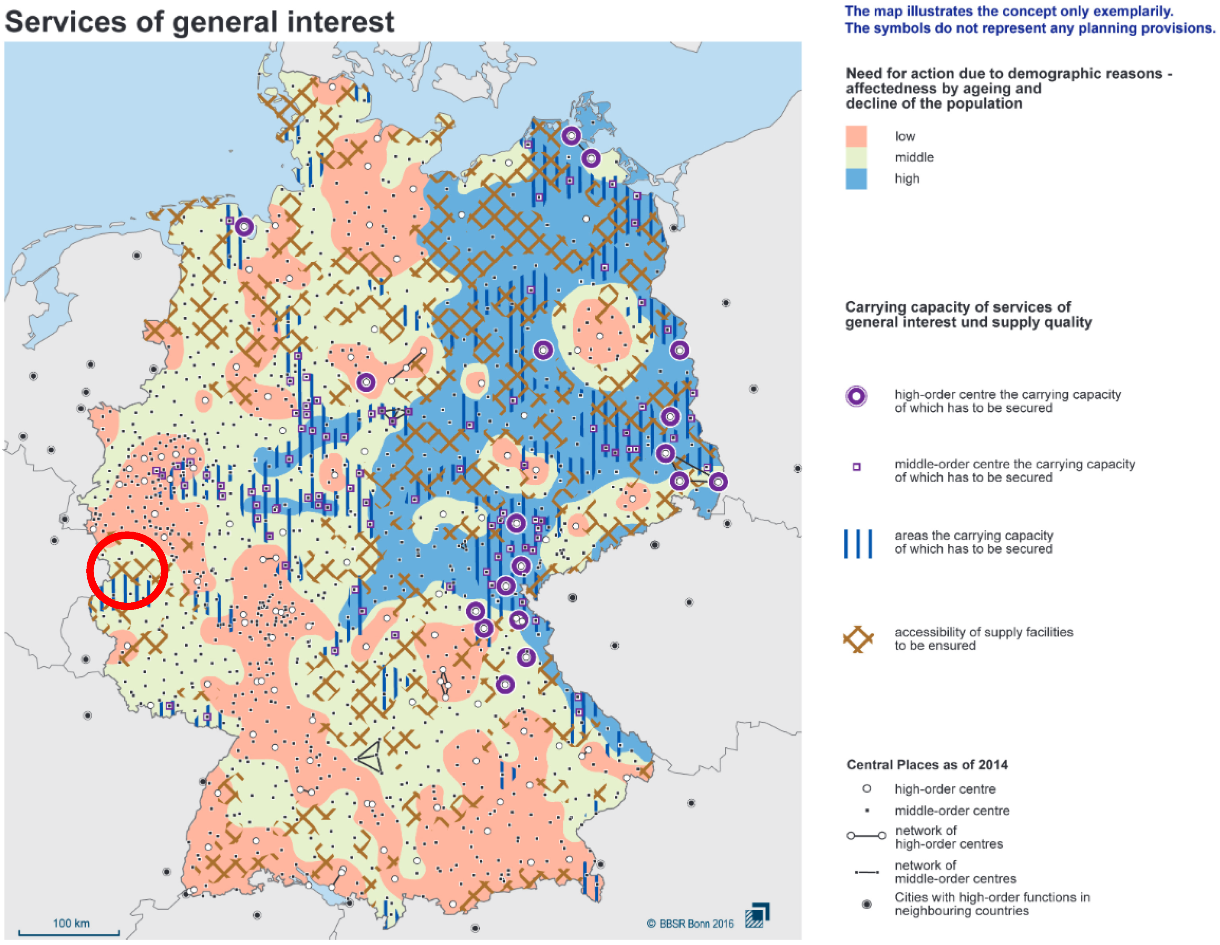
Concept 2 contains a visual overview on the current provision of SGI (see
Figure 1). The concept points at present unequal living conditions and identifies related need for action due to demographic reasons.
The county of Euskirchen, shown by the red cycle, belongs partly to areas with limited accessibility to SGIs and endangered accessibility to public transport.
Moreover, the German Federal Ministry of the Interior, Building and Community launched in 2019 a strategy on securing equal living conditions all over the country (BMI 2019). This strategy underlines the importance of SGI as key approach for securing equal living conditions (own translation): “Germany needs good and accessible SGI so that all people everywhere have good prospects for life and development. Reliable education, care, cultural and leisure services are of the utmost relevance for the decision: leave-or stay?” [
10] (p. 23).
In 2020, the German Federal Government established an equality check to be applied for all legislative acts on the federal level. The government intends to prove whether and how federal legislative projects affect the equivalence of people’s living conditions, for example, reduce, do not affect/consolidate, or reinforce unequal living conditions. For this purpose, among other indicators, the provision of SGI matters. Legislative projects must therefore be examined for their effects, particularly in the areas of local supply; health and care; participation of people with disabilities; reconciliation of family, care and work; childcare and education; security (police, fire department, disaster control) and administrative services [
11].
The provision of SGI has a specific local dimension. Art. 28 § 2 GG guarantees the inviolability of local self-government: “The municipalities must be guaranteed the right to regulate all matters of the local community within the framework of the law under their own responsibility.” These matters of the local community also encompass the independent provision of local SGI such as health care and education. The role of local communities is also laid down by Art. 8 § 1 Municipal Code of the Federal State of North-Rhine Westphalia of which the Rhenish mining area is a part of: “Municipalities shall create, within the limits of their capacity, the public facilities necessary for the economic, social and cultural care of their inhabitants” (own translation). That is why we focus in this paper on the quality-of-service provision of SGI in a local context by the example of the county of Euskirchen. The results were derived from the research project DAZWISCHEN (future-oriented structural change in the Rhenish lignite mining area). The project examined the structural changes in the region of the Rhenish lignite mining area and their local characteristics, both currently and in the future. In particular, the interrelationships between structural change, settlement and open space development, the mobility transition, the securing of SGI and, finally, impacts of climate change were studied.
This paper focuses on the spatial distribution of SGI. The related research questions are as follows:
How are SGI clustered and spatially distributed in the Rhenish coal-mining area?
Do all settlements in the Rhenish coal-mining area have equal access to SGI?
How can the provision of and access to SGI be improved in sparsely populated areas in order to reduce regional disparities in individual living conditions?
These questions are answered to quantify and, more important, qualify the present SGI in order to identify areas which are, in the context of the territorial cohesion, currently left behind. By acquiring this knowledge this paper aims to contribute towards a strategic policy regarding the access and the quality of SGI in rural areas of the Rhenish coal-mining area, with a special spotlight on the county of Euskirchen. The last questions imply and recommend specific actions to overcome existing inequalities.
Section 1 explains the legal and political framework of SGI within the European Union and Germany specifically and aims to highlight the necessity to achieve equal living standards on a countrywide scale. Afterwards the Materials used to quantify the status of SGI are presented. In addition,
Section 2 introduces the scientific method that was used. In
Section 3 the achieved results illustrate the current state of SGI within the Rhenish coal-mining area, replenished with an investigation regarding the broadband development. The following discussion compares the results with existing investigations and explains the differences between the outcomes. The conclusion at the end of the paper connects the research with ongoing strategic efforts in the county of Euskirchen to establish a regional development policy addressing existing issues.
2. Materials and Methods
The method used to display the status quo of the accessibility to SGI within the Rhenish coal-mining area is based on so called “kernel-density” estimates. Kernel density estimates have been used since the late 1950s [
12,
13], as an alternative to representing point distributions in histograms [
14]. Previous studies have already used Grids for the detection of intra-community centrality or location clusters [
15]. The results depend on the selected cell size (bandwidth), and also on the location of the grid cell network laid over the study area. Compared to this method, the kernel density approach has a clear advantage, because single kernel features can be “superimposed” on each point feature and thus not only the exact position of the point in space is weighted but all spatial units that lie within the range/bandwidth selected for the kernel.
The kernel density approach works in such a way that a “kernel” (density function) is created for each feature to be investigated. Raster cells close to the feature are weighted higher, and the weighting decreases with increasing distance decreases up to the outer bandwidth. The overlapping density functions are summed to produce a kernel density estimate (see
Figure 2).
A kernel function is particularly useful for phenomena which have a spatial character such as market areas, a provider such as a hospital or school offers services for. Then, for each grid cell, the kernel density value of the kernels within range is calculated by addition of the overlapping kernels, whereby smaller distances between the points are reflected in increased values.
The determined core densities are influenced much more strongly by the bandwidth used than by the shape of the kernel (core function). In this study the bandwidth (100 m × 100 m) was primarily chosen by visual inspection of preresults. In addition, several different bandwidths were discussed. Because the investigation area covers rural areas (such as the county of Euskirchen) same as dense areas, choosing a higher bandwidth could result in a higher quantity of extreme values.
The analysis performed in this case (as explained below) in that respect is not a sole kernel-density estimation., but a combination of two methods. The calculation of the distance is based on the nearest neighbour method while the chosen distance categories imply a kernel-density function. For example, a single cell without any facility types within its expansion is able to achieve high values if the cell is near an accommodation of facilities in adjacent cells. In this specific case the nonexisting facilities within the cell do not account towards the cells rating.
This analysis is based on data concerning several address-based geocoded Points of Interest provided by infas 360, Institut für angewandte Sozialwissenschaften GmbH (project partner in DAZWISCHEN). Including SGI of the health care sector, education, retail food sales, banking and post offices. Prior analyses dataset was checked, and duplicates of single facilities were removed.
To analyse the distribution of SGI in the Rhenish coal-mining area and their accessibility, a method is used which allows a quantification of the gravity of SGI. For this purpose, the zASB were chosen. zASBs are a main component of the regional plan issued by the district government of Cologne and embed in the principle 6.2-1 of the State Development Plan of North-Rhine Westphalia (LEP NRW) [
16]. Principle 6.2-1 states that “the expansion of settlements and their development should focus on those areas where a spatial accumulation of SGI (provided by state and private sector) is available” [
16] (p. 57).
The area under consideration (Rhenish coal-mining area) is overlaid by a vector raster with a specific cell size of 100 × 100 m using ArcGIS 15. This results in a grid layer with over 500,000 single cells. Due to the topography, not all grid cells have the same size; cells alongside the borders of North-Rhine Westphalia have a nonrectangular expansion. This guarantees that no space within the investigation area is left out of the analysis.
Based on the “zASB” evaluation of the district government of Cologne, a list of infrastructures was chosen. The list includes the following facility types (provided by infas 360):
The chosen types of facilities are important to evaluate the accessibility of SGI, mostly based on the studies of Borchardt and Gericke [
17,
18]. Each SGI within the Rhenish coal-mining area listed in
Table 1 is georeferenced in ArcGIS 15. Some SGI analysed by Borchardt and Gericke are not included such as stops of public transport, because they do not contribute to the gravity of SGI, but their accessibility which is analysed by QGIS.
Opposite to the zASB analysis by the district government of Cologne, the following facilities are not analysed: sports facilities and public baths were not included in the data provided by infas. Furthermore, types of schools were not differentiated for the same reason mentioned above, and the provided data only contained a single category for all types of schools.
To group the accessibility of different SGI, categories of distances are built and rated from 0 to 3 points (
Table 1). The shortest distance of the centroids of each grid cell to each particular SGI is calculated using open software QGIS plugin feature NNJoin (QGIS Version 3.16.10, NNJOin Version 3.1.3 by Håvard Tveite, NMBU). Resulting in a separate layer for each facility including a table with shortest distances of each grid cell centroid to different SGI (
Table 1).
This process results in 12 separate grid-based layers. Distances to each SGI are classified into 4 categories (from 0 to 3), where “0 points” represents the furthest distance of grid centroids towards SGI, and “3 points” represents the closest (see
Table 1). Categories distribution of four different SGI is displayed in
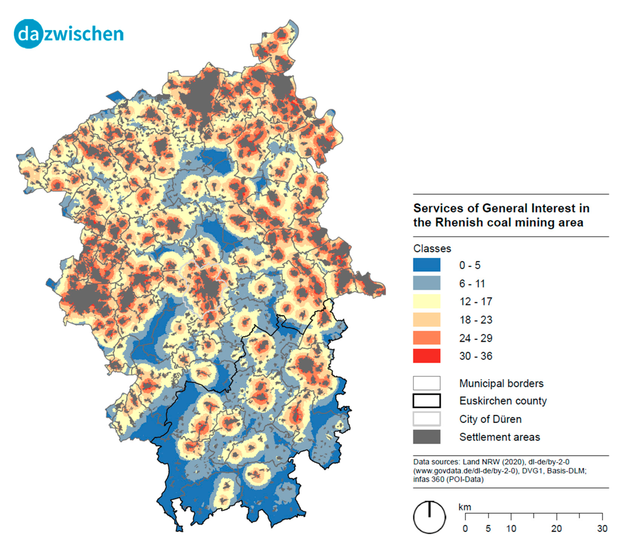
Figure 3. To evaluate the provision of all analysed SGI for each grid cell, points of each grid cell for different SGI were summed up, resulting in maximal 36 points and minimal 0 points. The values are classified into 6 equally distributed classes with values from 0–5, 6–11, 12–17, 18–23, 24–29, 30–36 using Excel 2016. The final values for each grid cell were rejoined into the input grid, to proceed with the final symbolization. A colour design was chosen from red (high score) to blue (low score). The resulting map was joined with districts of the Rhenish coal-mining area to display the accessibility of SGIs by all settlement areas (
Figure 4).
In addition, the status quo of broadband development (dataset provided by infas 360 GmbH) was taken into account. Therefore, the availability of different connection quality was investigated. The accessibility ranges from 30 Mbit/s over 100 Mbit/s, 400 Mbit/s to 1000 Mbit/s.
3. Results
The spatial distribution of the different SGI is quite different. For example, the SGI hair stylist shows the highest amount with 44 % of grid cells with the category 4 (longest distance) and only 5% in category 1 (closest distance). On the other hand, retirement homes throughout the Rhenish coal-mining area are up to 46% close to the grid cells centroid, while only 1% are considered to be in category 4 (0 points), which is the lowest amount of all SGI. Of course this can be explained with the distance categories used for the analysis. While hair stylists within <500 m distance to a grid cell centroid are considered to be near, for retirement homes a distance of <2000 m counts as near. On the other hand, the analysis was not only based on settled areas resulting in a wide range of values, too (
Figure 3).
The accessibility to food supply and medical care based on the calculated categories shows that the distribution of accessibility to food supply in the Rhenish coal-mining area is in category 1–2 (3–2 points) near to agglomerations while rural parts often belong to category 3–4 (0–1 Points). The same can be observed for the accessibility to medical care with a lower expression (
Figure 4 and
Figure 5).
Therefore, it is important to classify the calculated values and display them in the context of the settled areas within the Rhenish coal-mining area.
Figure 6 shows that rural areas are more likely in classes 1 or 2 (0–5 points, 6–11 points) while areas next to central districts are more likely in classes 3–6 (12–17 points, 18–23 points, 24–29 points, 30–36 points) (
Figure 3). The northern as well as eastern and western parts of the Rhenish coal-mining area show areas next to large cities, which mostly belongs to class 4–6 (18–23 points, 24–29 points, 30–36 points) of accessibility to SGI. The southern part of the investigated area shows more rural parts, which displays a class range from 1–3 (0–5 points, 6–11 points, 12–17 points). In this area, higher classes of accessibility to SGI are more frequently located in centralized settlements next to tiny villages (
Figure 6). Above all parts of municipality Hellenthal, Dahlem, Blankenheim and Bad Münstereifel in the southern part of the Rhenish coal-mining area show accessibility classes of 1–2, more frequently than the other parts of this area.
Broadband
In the Rhenish coal-mining area the northern parts as well as the western regions alongside the Dutch and Belgium borders and the Rhein-Kreis-Neuss District show a high coverage regarding access to 1000 Mbit/s. From these regions towards the City of Düren, which is located in the centre of the Rhenish coal-mining area, the coverage rate drops significantly. The same can be witnessed around the City Euskirchen and the City Schleiden. A lot of the regions with poor access to fibre optic line are currently used by the extractive industry. The broadband quality in the investigation area (by district) is listed below in descending order:
Rhein-Kreis-Neuss (74%), Stadt Mönchengladbach (68%, the only City in this enumeration), Städteregion Aachen (66%), Kreis-Heinsberg (59%), Rhein-Erft-Kreis (42%), Kreis Euskirchen (41%), Kreis Düren (39%). The average cover rate is 55%.
The county of Euskirchen can be separated into two regions regarding the broadband coverage, showing that in the northwestern parts of the county the coverage is way higher than in the southeastern parts. In general, 41% of all households are covered with a bandwidth of 1000 Mbit/s, and only 18% reach a bandwidth of less than 100 Mbit/s. While in the municipalities of Weilerswist, Dahlem, Stadt Schleiden and the city Euskirchen more than 50% of all households could have access to a fibre optic line, communities such as Blankenheim or Nettersheim reach a coverage of less than 20%.
The broadband coverage with a bandwidth of 1000 Mbit/s in the City of Düren is available for 63% of all households. In the centre of the city and the neighbourhoods Rölsdorf, Derichsweiler, Gürzenich, Arnoldsweiler and Grüngürtel more than 75% are covered with fibre optic line. For the northern and the southwestern parts of the city less than 10% of all households achieve this quality.
4. Discussion
The accessibility to SGIs in rural areas of the Rhenish coal-mining area is limited compared to areas near to agglomerations (
Figure 5). Nevertheless, more people move to suburban areas for different reasons. One reason is price development in urban areas [
19] and availability of affordable housing. Another reason is the establishment of mobile working opportunities during the COVID-19 pandemic, which resulted in a decoupling of place of residence and working place. Additional preference of living close to nature is an important factor leading people to move into suburban areas. This preference is invigorated during the lockdown periods during the course of the COVID-19 pandemic [
20].
In this context it seems to be that the inhabitant’s attitude towards a duration of accessibility of a SGI is not that important to some parts of population; other values are more taken into account.
The accessibility to different SGIs varies from region to region. Two indicators are discussed in more detail with a view to the southern rural part of the investigated area, especially the investigated subspace of the county of Euskirchen. Access to food supply in rural and suburban areas is lower than in urban areas (
Figure 5). However, rural areas in the southern part of the investigated area are often equipped with directly marketed farm products that are not included in this analysis. This is also important in view of petrol stations, which also often provide SGI in terms of food supply or post offices. They are mostly reachable in <15 min by car in the complete investigated area but have a limited assortment and higher prices than local food suppliers. Additionally, they are often only reachable by car, which limits the accessibility for people without one [
21]. Mobile shops and home delivery services are also not included as well as specialized food sales, such as bakeries, butcher or cheese factories, in the analysis, which may lead to lower categories for this indicator.
This assumption is also supported by a comparison of the accessibility of food sales to physicians/medical specialists. The availability of medical support is in categories 3 and 4, higher than the availability of food sales in the background of the same distance categorisation (
Table 1,
Figure 3,
Figure 4,
Figure 5 and
Figure 6). The well-structured accessibility to medical care in the Rhenish coal-mining area is in accordance with an analysis of the Association of Statutory Health Insurance Physicians, which emphasize a well-accessible primary health care in comparison to the nationwide average in Germany [
22].
Nonetheless, the availability of physicians and medical specialists in southern part is lower compared to the suburban and urban areas around the investigated area (
Figure 4). That means the time to reach medical care is higher in this part and is often linked to the usage of a car and longer time to arrange an appointment with a medical specialist. A times, doctors’ offices do not find a successor after retirement resulting in a sparseness of offices in rural parts. On average 28.9% of physicians in NRW are aged over 60 years, which may lead to the same development to other parts of the Rhenish coal-mining area as well [
22].
Another effect is that medicine graduates like to work part-time, which leads to three follow-ups to two retired physicians being needed [
23]. This situation has been tightened in the aftermath devastating flood disaster in July 2021. Centrally located settlement areas were destroyed and were no longer able to provide accessibility to different SGI including critical infrastructures. This is the case for public transport, sales, medical care and power supply. The highest affectedness is found in the county of Euskirchen within the Rhenish coal-mining area, which also already displays the lowest classes of accessibility to SGIs in ordinary times. Nontheless, Küpper and Steinführer point out that across all settlement and spatial types, improvements and deteriorations are perceived with regard to the provision of public services close to the place of residence [
24].
Digital platforms become more important in this context. In the course of digitalisation, the availability of different SGIs by such platforms is improved. The services provided by these platforms improve the availability of SGIs in rural areas, as well. These effects can be recognized for local supply with goods but also for basic medical care and education, as well as for social interactions. As these digital services were not investigated in this analysis in detail, the broadband expansion in rural parts of the Rhenish coal-mining area is an important indicator. Against the background, rural areas display a lower class of accessibility to SGIs; the allocation to a well-developed broadband access can be an essential factor to provide a basic supply [
25]. Digital platforms can be one way to improve the availability to SGIs in rural parts, which shows the importance of a broadband expansion.
For a valid statement more investigation is needed, because the demographic trend also needs to be included. Older segments of population are often not that familiar with digital platforms and internet applications. This might be induced by missing knowledge of how to use these services but also by a low confidence to digitalization and usage of digital services.
Even though the method used to analyse the structure of SGI within the Rhenish coal-mining area was inspired by the methodological approach, the district government of Cologne follows for the identification of suitable future settlement areas that are characterised by a spatially clustered profile of SGI (in German “zentralörtlich bedeutsame allgemeine Siedlungsbereiche”, zASB).
First, the amount of SGI in investigation. Where the district government of Cologne used 16 indicators, the authors of this article selected 12. As already mentioned in
Section 2, sports facilities, public baths and stops of public transport are not taken into account, but retirement homes are part of the analysis. Accessibility of retirement homes is important in the context of demographic change above all in the rural parts of the Rhenish coal-mining area, where, for example, the County Euskirchen belongs to, but also in the context of the demographic development of the whole area in future. In addition, there is no distinction between different types of school forms, such as elementary schools, high schools and professional schools. The distances to schools are rated with the same categorisation. The same procedure applies to physician and medical specialists, as explained in
Section 2.
Second, it is important to acknowledge that the investigated area does not focus on zASB [
26]. Despite the different spatial foci, there are some similarities to be mentioned. The Rhenish coal-mining area consists of the counties Heinsberg, city region Aachen, Düren, Euskirchen, Rhein-Erft and Rhein-Kreis Neuss. Rhein-Kreis Neuss is not part of the government district of Cologne. In addition, the City of Cologne, Rheinisch-Bergischer Kreis, Oberbergischer Kreis and Rhein-Sieg Kreis are not a part of the Rhenish coal-mining area. While these parts (except for Cologne) do have some rural parts to some extent, the City of Cologne (with the highest and densest population) does not count into the analysis. Cologne with its high-ranking supply utilities generates distant values far off from those achievable in rural areas. This can be seen alongside the eastern border of the Rhein-Erft-Kreis (
Figure 6).
The Rhenisch coal-mining area includes various parts of two government districts, the district government of Cologne and of Dusseldorf. Both districts have identified zASBs, as it is mandatory according to Principle 6.2-1 State Development Plan of North-Rhine Westphalia (LEP NRW) [
16].
What distinguishes both methods further are the chosen indicators and measurement values. For example, the district government of Cologne takes hospitals and gymnasiums into account, while these facilities are not part of the survey in Dusseldorf. On the other hand, Dusseldorf lists travel agencies, citizens’ offices and sports grounds, opposite of Cologne [
27].
As expected, the validity of the chosen method is limited. One of the main limitations is caused by the borders of the investigation area. All SGI considered by the analysis are located within the Rhinish coal-mining area. Facilities outside of this area are not taken into account, which may lead to lower classes of accessibility to SGI in areas close to the borders. Citizens in these areas are not bound to accomplish their needs within these boarders. If the next (regarding the distance) supermarket is located on the other side of the border, the values may not show the reality of facilities available to inhabitants. The same issue can be found alongside the borders towards the Netherlands and Belgium. In these areas in particular, the distances to certain facilities are not the main driver for choosing an SGI or a SGEI since economic reasons such as lower prices or certain goods are considered to be more important to people than the travel time.
As explained, the decision if a certain area is well supplied or not is based on different concepts. The categories cannot be transferred to any other region in Germany because the analysis and evaluation is not standardized. For example, in the low mountain range “Spessart” (Bavaria, Hesse) the standard for accessibility to a supermarket (full supply) is 15 min by car. In the county of Coburg on the other hand, the benchmark for 60% of all inhabitants in a single city quarter is set to a 5 min drive [
28] for the same facility type. For some parts of the Rhinish coal-mining area, above all for the rural areas, a different definition for accessibility maybe more specific targeted.
The provided data sets only contained facilities within the investigation area. Therefore, neither the positive nor the negative side effects of cross-border interactions to fulfil the daily needs of SGIs have impacts on the results.
However longer distances to reach SGIs in rural areas, of course, also induce that nearly two-thirds of all routes are covered by using a car [
29]. This is also supported by disadvantageous station times in rural areas [
30].
Although the county of Euskirchen is not directly affected by the lignite mining phase-out according to the definition of the EEFA, since there are no workplaces directly related to brown coal production or workplaces of RWE AG (coal mine operator and main energy supplier in western Germany) in the district, the occupation of energy-intensive companies with 16% of the employees subject to social security contributions nevertheless harbours an indirect impact [
31,
32]. Therefore, the loss of direct or indirect jobs will have an adverse effect on purchasing behaviour in the county of Euskirchen. A decrease in these expenditures may lead to a further decrease in jobs, which currently still benefit from the income-induced effects (e.g., retail trade) [
32]. The provision services of general interest in the county of Euskirchen may therefore also be affected by the phase-out of lignite mining and, as a consequence, deteriorate.
Based on the analysis carried out along with the inclusion of various concepts of the county of Euskirchen, such as the climate protection concept, the climate change adaptation strategy and the sustainability strategy, the DAZWISCHEN project provides the opportunity to create a strategy specifically customised for the region. This strategy offers the framework for a positive development of the county of Euskirchen with regard to the provision of SGI within the structural change. Reitzenstein et al. point out that achievements for one region are hardly transferrable to other (coal) regions due to very distinct characteristics within a country [
33]. Only building on the strength and assets of the region at hand can provide a successful structural change process [
33]. This is based on structural differences such as the number of inhabitants, density or the amount energy-intensive companies and the industrial workforce. Therefore, the established strategy and associated projects are due to the governance-based approach suitable for a future orientated and sustainable handling of lignite mining phase out based structural change [
34]. According to Art. 72 § 2 GG, a contribution to the preservation of equal living conditions is to be made by strengthening the individual responsibility for the development of regions. Based on Kötter et al. and Kersten et al., the inclusion of citizens in “strategies with cooperative approaches and private initiatives” can therefore contribute an essential part of future settlement development [
35,
36]. The developed strategy is suitable to improve the provision of SGIs by the identification of low accessibility to different services in rural parts on the one hand and development of governance based projects with relation to public services on the other hand.
5. Conclusions
The results we presented in this paper will be used for setting up a regional development strategy. One guidance principle is the maintenance of equal living conditions in the entire region and the reduction of intraregional disparities in individual living conditions. This requires a sound accessibility of SGI which is partly questioned in some southern parts of the region. In this context, reference has been made to the aforementioned four priority actions of the “Concepts and Strategies for Spatial Development in Germany”:
- -
Consistent application of central system: the methodological approach the district government of Cologne follows for the identification the settlement areas stipulates the allocation of future settlement areas in the vicinity of infrastructure clusters.
- -
Develop cooperative systems among municipalities
- -
Ensure the supply of sparsely populated rural areas with SGI
- -
Ensure accessibility by maintaining and improving the quality of public transport services
The central-location system of the district government is pursued by the strategy, since its focus is primarily intended to strengthen the provision of public services in the respective municipalities. Due to the fact that the strategy was developed in a participatory approach involving the different stakeholders, the system can be considered as a cooperative system among municipalities.
Sparsely populated areas within the county are considered within the strategy along with corresponding projects. Food vending machines are an example of this approach aiming to improve local supply and thus the provision of public services in rural areas.
In order to maintain and improve the quality of public transportation, projects such as the electrification of certain rail roads as well as a revised, tighter scheduling of trains are already being planned in order to improve the linkage between the individual towns and villages in the country where possible. The expansion of on-demand buses or car-sharing possibilities within sparsely populated regions are also being implemented.
As shown above, a regional development strategy can lead to a governance-based system between municipalities, which enables the region to identify sparsely supplied regions and can prevent a further decline of SGI in rural areas through specific future-orientated projects. Addressing disadvantageous situations on a countywide level using a cooperative policy and strategic approach can therefore provide an important keystone to encounter the problems of the structural change the county has to face in the near future.
Further research needs are related to the potential, partly deeply uncertain changes in the quality and accessibility due to demographic change, digitalisation and transport. Changes in location and quality of service provisions which are mostly privately operated cannot be precisely predicted. Transportation is considerably influenced by political decisions and related funding programs, but also marked-based factors such as energy prices. In consequence, scenario corridors seem to be appropriate for an identification of a bandwidth of potential future evolving conditions.


