
Urban Land Expansion Dynamics and Drivers in Peri-Urban Areas of China: A Case of Xiaoshan District, Hangzhou Metropolis (1985–2020)

Abstract
:1. Introduction
2. Materials
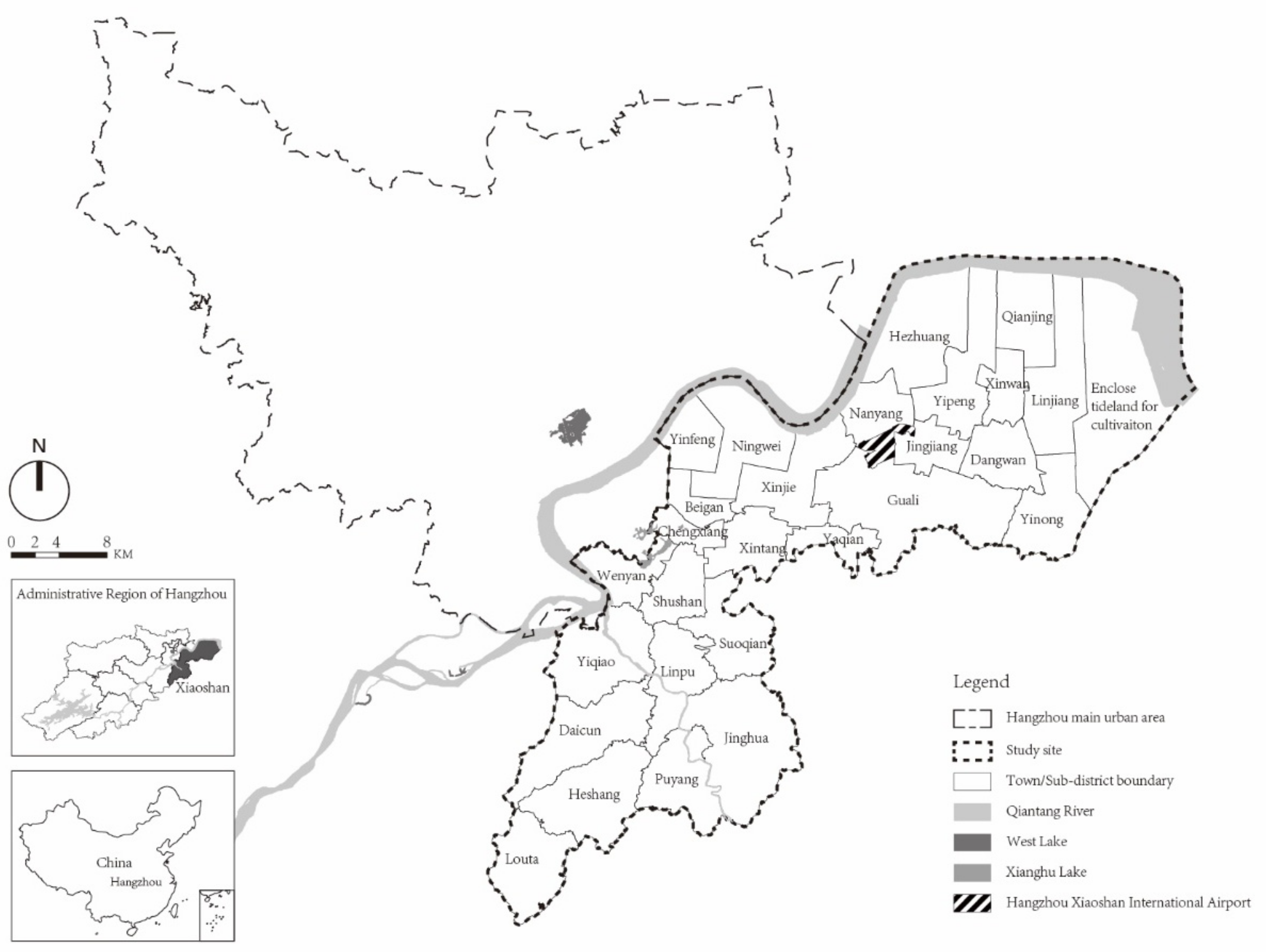
2.1. Study Area
2.2. Data Processing
2.2.1. Satellite Images
2.2.2. Demographic and Economic Data
3. Methods
3.1. Urban Land Expansion
3.2. Types of Urban Growth
3.3. Driving Factors
4. Results
4.1. Comparison of the Urban Expansion of Xiaoshan District and the Main Urban Area of Hangzhou
4.2. Leapfrog Growth Urban Expansion
4.3. Results of Logistic Regression Model
5. Discussion
5.1. Regional Development Drives the Transformation of Xiaoshan from Towns to the Peri-Urban Area
5.2. The Private Economy Influences the Pattern of Xiaoshan’s Urban Expansion
5.3. The Government Directly Influences the Urbanization Process of Xiaoshan through Policies and Regulations, Planning, and Infrastructure Construction
5.4. Major Events Accelerate Changes in Xiaoshan’s Urban Spatial Structure
6. Conclusions
Author Contributions
Funding
Institutional Review Board Statement
Informed Consent Statement
Data Availability Statement
Acknowledgments
Conflicts of Interest
References
- Desa, U. Revision of World Urbanization Prospects; United Nations Department of Economic and Social Affairs: New York, NY, USA, 2018. [Google Scholar]
- National Bureau of Statistics of China. Statistical Communiqué of the People’s Republic of China on the 2020 National Economic and Social Development. Available online: http://www.stats.gov.cn/english/PressRelease/202102/t20210228_1814177.html (accessed on 28 February 2021).
- Wei, Y.D. Beyond the Sunan Model: Trajectory and Underlying Factors of Development in Kunshan, China. Environ. Plan. A Econ. Space 2002, 34, 1725–1747. [Google Scholar] [CrossRef]
- Ma, L.J.C.; Fan, M. Urbanisation from Below: The Growth of Towns in Jiangsu, China. Urban Stud. 1994, 31, 1625–1645. [Google Scholar] [CrossRef]
- Wu, F.; Xu, J.; Yeh, A.G. Urban Development in Post-Reform China: State, Market, and Space; Routledge: London, UK, 2006. [Google Scholar]
- Lin, G.C. China’s industrialization with controlled urbanization: Anti-urbanism or urban-biased? Issues Stud. 1998, 34, 98–116. [Google Scholar]
- Shen, J.; Wong, K.; Feng, Z. State-sponsored and spontaneous urbanization in the Pearl River Delta of south China, 1980–1998. Urban Geogr. 2002, 23, 674–694. [Google Scholar] [CrossRef]
- Shen, J. Understanding dual-track urbanisation in post-reform China: Conceptual framework and empirical analysis. Popul. Space Place 2006, 12, 497–516. [Google Scholar]
- Shen, J.; Feng, Z.; Wong, K. Dual-track urbanization in a transitional economy: The case of Pearl River Delta in South China. Habitat Int. 2006, 30, 690–705. [Google Scholar] [CrossRef]
- Lin, G.C. Land development under rapid industrialization and urbanization: Jiangsu. In Developing China; Routledge: London, UK, 2009; pp. 251–280. [Google Scholar]
- Tong, D.; Wang, X.; Wu, L.; Zhao, N. Land ownership and the likelihood of land development at the urban fringe: The case of Shenzhen, China. Habitat Int. 2018, 73, 43–52. [Google Scholar]
- Zou, Y.; Zhao, W.; Mason, R. Marketization of collective-owned rural land: A breakthrough in Shenzhen, China. Sustainability 2014, 6, 9114–9123. [Google Scholar] [CrossRef]
- Lin, L.; Shen, J. Spatial patterns and driving forces of uneven dual-track urbanisation in Fujian Province: An approach based on employment sectors. Urban Stud. 2019, 56, 2568–2584. [Google Scholar]
- Qian, J.; Feng, D.; Zhu, H. Tourism-driven urbanization in China’s small town development: A case study of Zhapo Town, 1986–2003. Habitat Int. 2012, 36, 152–160. [Google Scholar] [CrossRef]
- Wang, L.; Wong, C.; Duan, X. Urban growth and spatial restructuring patterns: The case of Yangtze River Delta Region, China. Environ. Plan. B Plan. Des. 2016, 43, 515–539. [Google Scholar] [CrossRef]
- Živanović-Miljković, J.; Crnčević, T.; Marić, I. Land use planning for sustainable development of peri-urban zones. Spatium 2012, 28, 15–22. [Google Scholar] [CrossRef]
- Iaquinta, D.L.; Drescher, A.W. Defining the peri-urban: Rural-urban linkages and institutional connections. Land Reform 2000, 2, 8–27. [Google Scholar]
- Long, H.; Tang, G.; Li, X.; Heilig, G.K. Socio-economic driving forces of land-use change in Kunshan, the Yangtze River Delta economic area of China. J. Environ. Manage. 2007, 83, 351–364. [Google Scholar] [CrossRef] [PubMed]
- Tan, M.; Li, X.; Xie, H.; Lu, C. Urban land expansion and arable land loss in China—A case study of Beijing–Tianjin–Hebei region. Land Use Policy 2005, 22, 187–196. [Google Scholar] [CrossRef]
- Bhatta, B.; Saraswati, S.; Bandyopadhyay, D. Urban sprawl measurement from remote sensing data. Appl. Geogr. 2010, 30, 731–740. [Google Scholar] [CrossRef]
- Catalán, B.; Saurí, D.; Serra, P. Urban sprawl in the Mediterranean?: Patterns of growth and change in the Barcelona Metropolitan Region 1993–2000. Landsc. Urban Plan 2008, 85, 174–184. [Google Scholar] [CrossRef]
- Kasanko, M.; Barredo, J.I.; Lavalle, C.; McCormick, N.; Demicheli, L.; Sagris, V.; Brezger, A. Are European cities becoming dispersed?: A comparative analysis of 15 European urban areas. Landsc. Urban Plan 2006, 77, 111–130. [Google Scholar] [CrossRef]
- Schneider, A.; Woodcock, C.E. Compact, dispersed, fragmented, extensive? A comparison of urban growth in twenty-five global cities using remotely sensed data, pattern metrics and census information. Urban Stud. 2008, 45, 659–692. [Google Scholar] [CrossRef]
- Peiser, R.B. Density and urban sprawl. Land Econ. 1989, 65, 193–204. [Google Scholar] [CrossRef]
- Ju, H.; Zhang, Z.; Zuo, L.; Wang, J.; Zhang, S.; Wang, X.; Zhao, X. Driving forces and their interactions of built-up land expansion based on the geographical detector–a case study of Beijing, China. Int. J. Geogr. Inf. Sci. 2016, 30, 2188–2207. [Google Scholar] [CrossRef]
- Khajeh Borj Sefidi, A.; Ghalehnoee, M. Analysis of urban growth pattern using logistic regression modeling, spatial autocorrelation and fractal analysis Case study: Ahvaz city. Iran Univ. Sci. Technol. 2016, 26, 183–194. [Google Scholar]
- Poelmans, L.; Van Rompaey, A. Complexity and performance of urban expansion models. Comput. Environ. Urban Syst. 2010, 34, 17–27. [Google Scholar] [CrossRef]
- Kleinbaum, D.G.; Dietz, K.; Gail, M.; Klein, M.; Klein, M. Logistic Regression; Springer: Berlin/Heidelberg, Germany, 2002. [Google Scholar]
- Nong, Y.; Du, Q. Urban growth pattern modeling using logistic regression. Geo-Spat. Inf. Sci. 2011, 14, 62–67. [Google Scholar] [CrossRef]
- Liao, F.H.; Wei, Y. Modeling determinants of urban growth in Dongguan, China: A spatial logistic approach. Stoch. Environ. Res. Risk Assess. 2014, 28, 801–816. [Google Scholar] [CrossRef]
- Alsharif, A.A.; Pradhan, B. Urban sprawl analysis of Tripoli Metropolitan city (Libya) using remote sensing data and multivariate logistic regression model. J. Indian Soc. Remote Sens. 2014, 42, 149–163. [Google Scholar] [CrossRef]
- Salem, M.; Bose, A.; Bashir, B.; Basak, D.; Roy, S.; Chowdhury, I.R.; Alsalman, A.; Tsurusaki, N. Urban expansion simulation based on various driving factors using a logistic regression model: Delhi as a case study. Sustainability 2021, 13, 10805. [Google Scholar] [CrossRef]
- Dong, G.; Xu, E.; Zhang, H. Spatiotemporal variation of driving forces for settlement expansion in different types of counties. Sustainability 2015, 8, 39. [Google Scholar] [CrossRef]
- Braimoh, A.K.; Onishi, T. Spatial determinants of urban land use change in Lagos, Nigeria. Land Use Policy 2007, 24, 502–515. [Google Scholar] [CrossRef]
- Liu, H. Comprehensive carrying capacity of the urban agglomeration in the Yangtze River Delta, China. Habitat Int. 2012, 36, 462–470. [Google Scholar] [CrossRef]
- Wang, F.; Zhou, Y. Modelling urban population densities in Beijing 1982-90: Suburbanisation and its causes. Urban Stud. 1999, 36, 271–287. [Google Scholar] [CrossRef]
- Zhao, S.; Zhou, D.; Zhu, C.; Qu, W.; Zhao, J.; Sun, Y.; Huang, D.; Wu, W.; Liu, S. Rates and patterns of urban expansion in China’s 32 major cities over the past three decades. Landsc. Ecol. 2015, 30, 1541–1559. [Google Scholar] [CrossRef]
- Janssen, L.L.; Vanderwel, F.J. Accuracy assessment of satellite derived land-cover data: A review. Photogramm. Eng. Remote Sens. 1994, 60, 426–479. [Google Scholar]
- Wilson, E.H.; Hurd, J.D.; Civco, D.L.; Prisloe, M.P.; Arnold, C. Development of a geospatial model to quantify, describe and map urban growth. Remote Sens. Environ. 2003, 86, 275–285. [Google Scholar] [CrossRef]
- Wu, W.; Zhao, S.; Zhu, C.; Jiang, J. A comparative study of urban expansion in Beijing, Tianjin and Shijiazhuang over the past three decades. Landsc. Urban Plan 2015, 134, 93–106. [Google Scholar] [CrossRef]
- Fei, W.; Zhao, S. Urban land expansion in China’s six megacities from 1978 to 2015. Sci. Total Environ. 2019, 664, 60–71. [Google Scholar] [CrossRef]
- Seto, K.C.; Fragkias, M.; Güneralp, B.; Reilly, M.K. A meta-analysis of global urban land expansion. PLoS ONE 2011, 6, e23777. [Google Scholar] [CrossRef]
- Xu, X.; Min, X. Quantifying spatiotemporal patterns of urban expansion in China using remote sensing data. Cities 2013, 35, 104–113. [Google Scholar] [CrossRef]
- Forman, R. Land Mosaics: The ecology of landscapes and regions (1995). Ecol. Des. Plan. Read. 2014, 84, 217–234. [Google Scholar]
- Xu, C.; Liu, M.; Zhang, C.; An, S.; Yu, W.; Chen, J.M. The spatiotemporal dynamics of rapid urban growth in the Nanjing metropolitan region of China. Landsc. Ecol. 2007, 22, 925–937. [Google Scholar] [CrossRef]
- Liu, R.; Zhu, D.; Zhu, Z.; Yang, W. Analysis of the driving forces of urban sprawl in Dezhou city based on a Logistic regression model. Resour. Sci. 2009, 31, 1919–1926. [Google Scholar]
- Qiang, L.; Zhiyuan, R. Spatial statistics and simulation of the land use change based on binary logistic regression. Stat. Inform. Forum. 2012, 27, 98–103. [Google Scholar]
- Luo, J.; Wei, Y.D. Modeling spatial variations of urban growth patterns in Chinese cities: The case of Nanjing. Landsc. Urban Plan 2009, 91, 51–64. [Google Scholar] [CrossRef]
- Tian, Y.; Qian, J. Suburban identification based on multi-source data and landscape analysis of its construction land: A case study of Jiangsu Province, China. Habitat Int. 2021, 118, 102459. [Google Scholar] [CrossRef]
- Xiao, R.; Liu, Y.; Huang, X.; Shi, R.; Yu, W.; Zhang, T. Exploring the driving forces of farmland loss under rapidurbanization using binary logistic regression and spatial regression: A case study of Shanghai and Hangzhou Bay. Ecol. Indic. 2018, 95, 455–467. [Google Scholar] [CrossRef]
- Li, X.; Zhou, W.; Ouyang, Z. Forty years of urban expansion in Beijing: What is the relative importance of physical, socioeconomic, and neighborhood factors? Appl. Geogr. 2013, 38, 1–10. [Google Scholar] [CrossRef]
- Yue, W.; Liu, Y.; Fan, P. Measuring urban sprawl and its drivers in large Chinese cities: The case of Hangzhou. Land Use Policy 2013, 31, 358–370. [Google Scholar] [CrossRef]
- Yang, Y.; Jin, P.; Zhu, X. Change of land use in process of urbanization in Hangzhou during past 30 years. J. ZheJiang Univ. (Eng. Sci.) 2017, 51, 1462–1474. [Google Scholar]
- Shen, X.; Ma, L.J.C. Privatization of rural industry and de facto urbanization from below in southern Jiangsu, China. Geoforum 2005, 36, 761–777. [Google Scholar] [CrossRef]
- Shu, B.; Zhang, H.; Li, Y.; Qu, Y.; Chen, L. Spatiotemporal variation analysis of driving forces of urban land spatial expansion using logistic regression: A case study of port towns in Taicang City, China. Habitat Int. 2014, 43, 181–190. [Google Scholar] [CrossRef]
- Yang, R.; Zhang, J.; Xu, Q.; Luo, X. Urban-rural spatial transformation process and influences from the perspective of land use: A case study of the Pearl River Delta Region. Habitat Int. 2020, 104, 102234. [Google Scholar] [CrossRef]
- Li, Y.; Wu, F. The emergence of centrally initiated regional plan in China: A case study of Yangtze River Delta Regional Plan. Habitat Int. 2013, 39, 137–147. [Google Scholar] [CrossRef]
- Lichtenberg, E.; Ding, C. Assessing farmland protection policy in China. Land Use Policy 2008, 25, 59–68. [Google Scholar] [CrossRef]
- Zhang, T. Land market forces and government's role in sprawl: The case of China. Cities 2000, 17, 123–135. [Google Scholar] [CrossRef]


| System | Satellite | Path/Row | Date of Acquisition | Spatial Resolution |
|---|---|---|---|---|
| Landsat TM | Landsat-5 | 119/39 | 22 July 1985 | 30 m |
| Landsat ETM+ | Landsat-7 | 119/39 | 4 May 2000 | 30 m |
| Landsat TM | Landsat-5 | 119/39 | 24 May 2010 | 30 m |
| Landsat OLI_TIRS | Landsat-8 | 119/39 | 19 May 2020 | 30 m |
| 1985–2000 | 2000–2010 | 2010–2020 | Average | |
|---|---|---|---|---|
| UI (km2) | ||||
| Xiaoshan | 2.19 | 8.42 | 8.58 | 5.80 |
| Hangzhou’s main urban area | 2.83 | 15.78 | 14.18 | 9.77 |
| UE (%) | ||||
| Xiaoshan | 2.38 | 6.74 | 4.11 | 6.30 |
| Hangzhou’s main urban area | 1.20 | 5.66 | 3.25 | 4.13 |
| Period | Growth Type | Area (km2) | Percentage (%) | Rate of Industrial Land (%) |
|---|---|---|---|---|
| 1985–2000 | Infilling | 3.14 | 7.10 | 16.85 |
| Edge growth | 30.70 | 87.27 | 16.09 | |
| Leapfrog | 2.59 | 9.63 | 16.29 | |
| All | 36.43 | 100.00 | 16.17 | |
| 2000–2020 | Infilling | 48.50 | 28.45 | 6.84 |
| Edge growth | 84.97 | 49.84 | 32.29 | |
| Leapfrog | 37.00 | 21.71 | 80.31 | |
| All | 170.47 | 100.00 | 35.47 |
| Driving Factors | B | Standard Error | Wald | Significance | Exp(B) |
|---|---|---|---|---|---|
| slope | −0.01546 | 0.02880 | 0.288 | 0.59156 | 0.98466 |
| density of agricultural land | −0.48702 | 0.29413 | 2.742 | 0.09776 | 0.61445 |
| distance to inter-city highway | 0.00001 | 0.00004 | 0.059 | 0.80795 | 1.00001 |
| distance to local artery roads | −0.00064 | 0.00011 | 34.119 | 0.00003 | 0.99936 |
| distance to major city centers | −0.00005 | 0.00001 | 15.413 | 0.00009 | 0.99996 |
| distance to town/subdistrict centers | −0.00038 | 0.00006 | 45.242 | 0.00012 | 0.99962 |
| value of population density change | 0.00015 | 0.00016 | 0.844 | 0.35835 | 1.00015 |
| Added value of GDP | −0.39291 | 0.47606 | 0.681 | 0.40918 | 0.67509 |
| primary industrial increment | 0.34223 | 0.48487 | 0.498 | 0.48030 | 1.40808 |
| secondary industrial increment | 0.39221 | 0.47566 | 0.680 | 0.40962 | 1.48025 |
| tertiary industrial increment | 0.41081 | 0.47534 | 0.747 | 0.38796 | 1.50803 |
| Constants | 0.24862 | 0.34610 | 0.516 | 0.47154 | 1.28226 |
Publisher’s Note: MDPI stays neutral with regard to jurisdictional claims in published maps and institutional affiliations. |
© 2022 by the authors. Licensee MDPI, Basel, Switzerland. This article is an open access article distributed under the terms and conditions of the Creative Commons Attribution (CC BY) license (https://creativecommons.org/licenses/by/4.0/).
Share and Cite
Chen, Y.; He, Y. Urban Land Expansion Dynamics and Drivers in Peri-Urban Areas of China: A Case of Xiaoshan District, Hangzhou Metropolis (1985–2020). Land 2022, 11, 1495. https://doi.org/10.3390/land11091495
Chen Y, He Y. Urban Land Expansion Dynamics and Drivers in Peri-Urban Areas of China: A Case of Xiaoshan District, Hangzhou Metropolis (1985–2020). Land. 2022; 11(9):1495. https://doi.org/10.3390/land11091495
Chicago/Turabian StyleChen, Yufan, and Yong He. 2022. "Urban Land Expansion Dynamics and Drivers in Peri-Urban Areas of China: A Case of Xiaoshan District, Hangzhou Metropolis (1985–2020)" Land 11, no. 9: 1495. https://doi.org/10.3390/land11091495
APA StyleChen, Y., & He, Y. (2022). Urban Land Expansion Dynamics and Drivers in Peri-Urban Areas of China: A Case of Xiaoshan District, Hangzhou Metropolis (1985–2020). Land, 11(9), 1495. https://doi.org/10.3390/land11091495