Article

The Social, Political, and Environmental Dimensions in Designing Urban Public Space from a Water Management Perspective: Testing European Experiences

1
Water and Territory Research Group, Interuniversity Institute of Geography, University of Alicante, 03690 San Vicente del Raspeig, Spain
2
Environmental Intelligence for Global Change Lab, Department of Electronics, Information and Bioengineering, Politecnico di Milano, 20133 Milan, Italy
3
Department of Civil Engineering and Architecture, University of Pavia, 27100 Pavia, Italy
4
Geography Department, Autonomous University of Barcelona, 08193 Barcelona, Spain
*
Author to whom correspondence should be addressed.
Land 2022, 11(9), 1575; https://doi.org/10.3390/land11091575
Submission received: 21 July 2022 / Revised: 8 September 2022 / Accepted: 13 September 2022 / Published: 15 September 2022

Abstract

:
Urban areas are increasingly experiencing extreme weather events, especially related to water (e.g., droughts, heatwaves, floods), which are devastatingly impacting infrastructure and human lives. Compact cities, conceived to create more robust, effective, and sustainable environments, are under pressure to increase their resilience by co-producing adaptive strategies mainly focused on the urban public space. However, public space design tends to face environmental challenges without sufficiently exploring their intersection with social issues (citizens living conditions and vulnerability) and political structures (governance). This contribution delves into how urban public space interventions are (not) moving towards achieving urban resilience in an integrated way instead of sectoral. A triple-loop approach has been developed and tested in ten urban public spaces in European compact cities in the last 25 years. The results report how most projects reinforce the social dimension by promoting citizen well-being through new quality standards in public spaces, excluding some citizenry’s vulnerable segments (immigrants, women, and disabled). The political dimension reinforces hard adaptation measures to manage water resources, although increasing attention is put on nature-based solutions, and most projects ensure participation processes. Finally, the environmental dimension is the most transversal by increasing land conversion, ensuring flooding mitigation, and enhancing adaptive capacity.

1. Introduction

Projections show that by 2050 nearly 70% of the world’s population will live in urban areas [1]. Urbanization and densification processes have led to severe environmental degradation and biodiversity loss [2,3], and their effects are maximized by climate change and the likely increase in frequency and severity of environmental hazards such as droughts, floods, and heatwaves [4], along with other climate-related hazards able to increase overall vulnerability [5,6,7,8]. Devising strategies to manage more concentrated climate hazards will be especially challenging because urban areas interact with and influence climate in ways that amplify (worsen) impacts and reduce urban resilience [9,10]. Since cities constitute socioecological systems, combining ecology with urban planning and design has been recommended to increase urban resilience [11]. Resilience is the ability of a system to recover its original equilibrium after being exposed to either gradually increasing pressures or abrupt shocks, generally inducing complex non-linear interactions between the system components and acting across a variety of spatial and temporal scales [12]. Increasing the resilience of a system to a specific stressor (e.g., climate change) or, perhaps more appropriately, to a set of stressors (e.g., climate change + increased pollution + reduced green coverage + economic and/or pandemic crises), either correlated or independent, helps to prevent or mitigate adverse impacts, and represents a necessary objective of any management plan, especially when strategies need to be designed for particularly vulnerable communities and places, and trade-offs must be established between development and sustainability. In the urban planning context, resilience assessment has often been confined to a reduced number of dimensions, which in fact, only describe an idealized urban system usually from the engineering perspective, with little consideration of long-term impacts, cross-scale cascading effects, and of the overall sustainability of proposed solutions [13]. In recent years, planners have alternatively defined the urban system as the aggregation of different subsets of a broad spectrum of components across the fields of engineering, ecology, economics, geography, climate science, sociology, etc. [14], assessing their individual or collective resilience to shocks or stresses originating from climate change, socioeconomic decline, and environmental disturbances. Nevertheless, it has been argued that insufficient attention has been paid to the role of key social issues (e.g., public access to facilities, equity, justice, empowerment, disruption of vulnerable physical and virtual spaces) in determining the comprehensive resilience of the urban space, potentially giving rise to severe flaws in the proposed solutions [15].
Governments have employed different strategies to strengthen urban resilience and control rapid urban sprawl and population growth in a climate change context. One strategy is the “compact city”, conceived as an urban planning-based approach to creating more robust, effective, and sustainable environments [16]. Compact city policies respond to many urban issues, such as land consumption in fringe areas, energy and resource waste, air pollution, accessibility, and social segregation [17]. However, one primary constraint to compact cities (and of interest in this paper) is the low proportion of public spaces [18] and, consequently, the claim for re-thinking urban public space design [19]. In this work, public spaces refer to any parcel of land or water with some level of vegetation that is essentially devoted to an open space used for outdoor recreation. Precisely, open space constitutes the space where it is possible to promote urban development and transformation processes where the balance between the natural environment and anthropic development is recovered. In Western culture, public spaces are commonly understood as places accessible by all for free and without a profit motive, with the basic objective of facilitating social interaction. Furthermore, it uses “public” to refer to ownership by a national or local government body, a nongovernment body in trust for the public, or a private individual or organisation available for public use or access [20]. Urban planning decisions simultaneously determine the level of access to public spaces (including housing and other essential services) and the ability of urban areas to provide greater social welfare while lowering emissions and improving environmental quality [21].
Whether directly or indirectly, climate change impacts compact cities’ infrastructure, requiring specific actions to adjust urban public spaces with locational-specific solutions [22]. Traditional approaches of “grey infrastructure” (typically the human-engineered and centralized water management works) have been developed to manage runoff and reduce flood risk. However, these approaches are prone to fail in building adaptive cities [23]. The uncertainty, rapid change, and complexity of compact cities require new views to address contemporary urban dynamics and ensure that long-term sustainable development can be realized [24]. Since the 1990s, many cities have progressively adopted policies to reshape urban infrastructure in order to address urban resilience, water quality, and sustainability goals [25,26]. Blue-green infrastructure (BGI), also known as nature-based solutions (NBS), has gained interest in the recent past [27]. BGI adds significant potential to the urban drainage domain to manage flood risk and mitigate other climate change impacts such as heatwaves or heat island effects while ensuring a timely and coordinated response to extreme events [28]. BGI is defined as an interconnected network of natural and designed landscape components that may include intermittent and perennial water bodies and open, green spaces to provide water storage, flood control and water purification [29] to gain flexibility in the planning of urban landscapes [30]. There is increasing interest among city practitioners in using these NBS as a broad set of actions to promote human well-being in cities interested in restoring aspects of “natural” (designed as natural) ecosystem structures and/or functions [31]. More and more cities consider these solutions an integral part of their water management plans because they are cost-effective, address societal challenges, enable resource recovery and ecosystem restoration, and promote human well-being [32,33].
As a key element in building inclusive, healthy, functional, and productive cities [34], BGI targets open public spaces to provide the cities with environmental, social, economic and health benefits while ensuring liveability [35]. Likewise, public spaces and related elements are generally referred to as urban green infrastructure (UGI) and provide benefits through ecosystem services (e.g., microclimate regulation by reducing cities’ heat levels and increasing thermal comfort) [36]. By addressing pressing issues such as temperature increases, poor environmental quality, and limited social inclusion, UGI contributes to the mitigation of broader urban sustainability challenges, such as climate change impacts, outdoor recreation, and spaces for relational activity [37,38]. The spatial layout and the quality of public spaces are becoming increasingly important, emphasising the need to integrate different social groups to minimise social inequalities [39]. The World Health Organization recommends a minimum of 9 m2 green open space per person. Nearly 40% of the surface area of European cities is made up of urban green infrastructure, with around 18 m2 of publicly accessible green space per inhabitant [40]. However, national and local guidelines on adequate public space differ significantly from place to place. The variety and quality of available space are also substantial in terms of social justice, referring to how accessible public space is to users in different neighbourhoods or if public space is catering for the most vulnerable groups of city users. Indeed, it is argued that public space constitutes not only the space where the right to the city emerges; it is where it is implemented and represented, providing a key tool for social interaction [41]. In particular, elderly people, families with children, and young people are critical social groups potentially enjoying UGI and benefit from easy access [42,43].
Attention to environmental issues in compact cities has shifted from the building performance to the role of public spaces that show greater resilience and adaptive capacity: public spaces that act directly on the ground/soil and are almost always publicly owned or single managed. Local governments have an essential role—politically, economically, culturally and socially—in ensuring urban resilience through public space management [44]. The UN’s New Urban Agenda, the Agenda 2030, the Paris Agreement on Climate Change, and the Sendai Framework for Disaster Risk Reduction acknowledge the contribution that cities and local authorities play in achieving their targets. The 2030 Agenda for Sustainable Development, adopted in 2015 as a plan of action for people, the planet and prosperity, includes 17 Sustainable Development Goals (SDGs). SDG 11 is targeted explicitly at building sustainable cities and communities, making cities inclusive, safe, resilient and sustainable. In particular, Target 11.7 highlights the importance of providing green public spaces, safe, inclusive and accessible for all [45], including access to green and public spaces for all strata of society. Cities themselves also have a significant role in achieving other goals by 2030. In support of the urban agendas, cities should promote inclusiveness, equity, and liveability, besides guaranteeing an environment that stimulates social relationalities.
Cities are complex systems whose infrastructural, economic, and social components are strongly interrelated and difficult to understand in isolation [46]. As dynamic systems, cities are characterised by multiple pathways of development that co-exist, being unsuitable for understanding complexity by analysing each component separately [47]. Accordingly, cities need an integrated approach to mitigating climate change, considering urban development, risk management, and citizens’ well-being. This contribution examines recent urban planning initiatives implemented in ten European cities to regenerate the urban space, adapt to climate change and improve local water management. In particular, we explore how the different strategies have been applied in practice. We attempt to verify if such solutions have been generally perceived as beneficial in increasing social cohesion, public participation, and citizen engagement, besides achieving their primary environmental and climate-change adaptation goals. An evidence-based analysis of the dynamics of public urban space design, management and use is proposed to highlight positive (negative) feedback across the three dimensions (social, political and environmental). Furthermore, we evaluate if initiatives also increase (reduce) the overall well-being and the social inclusion of the resident population, thus reinforcing the original sustainability goals.

2. Materials and Methods

This article conducts an evidence-based analysis of the main driving factors considered when addressing urban resilience from urban public spaces under a water management perspective. In practice, this means scaling up experiences (identified as selected case studies), learning from a triple-loop approach (social, political and environmental), identifying failures and barriers in urban public space development, and exchanging new knowledge from examples at multiple geographic scales. Three research questions are formulated:
  • RQ1: Which type of public spaces’ design strategies and actions are promoted to increase cities’ resilience; do citizens take part in decision-making processes leading towards increased resilience?
  • RQ2: Can a trend towards a more comprehensive incorporation of social issues in urban designing and planning be identified?
  • RQ3: How do political strategies affect public space design to face climate change, and which social and environmental benefits can be expected?

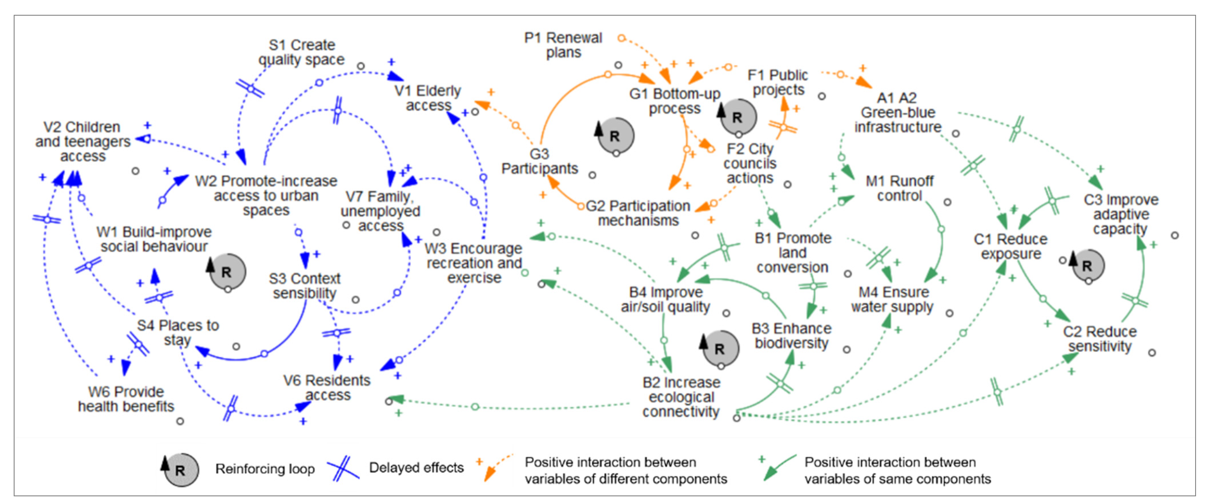
2.1. Data Collection

Starting from a brief literature review containing conceptual and empirical approaches regarding urban resilience and NBS (BGI), we investigated the main urban design repositories with local experiences on reshaping public spaces from a water management perspective. The most relevant was the Urban data Platform Plus of the European Commission (https://urban.jrc.ec.europa.eu/?lng=en&ctx=udp (accessed on 14 May 2022)), with a particular interest in “The future of cities” theme, the “Atlas of the nature” provided by the Naturvation project (https://naturvation.eu/atlas.html (accessed on 14 May 2022)), and the “Urban green blue grids for resilient cities” website (https://naturvation.eu/atlas.html (accessed on 14 May 2022)), produced by the Atelier Groenblauw, in the Netherlands. The search has been limited to the last 25 years (the period in which the grey infrastructure approach started to be contested), combining northern and southern European realities in line with the regional approach followed by the EU Adaptation Strategy and the Knowledge Centre for Territorial Policies initiative shared by the Joint Research Centre and the Directorate General for Regional and Urban Policy of the European Commission.
Following the statement from [14] for which the value of resilience as an agenda for cities can only be assessed by considering actual examples of resilience in action, we report ten local experiences from compact cities (Table 1), asking whether and, if so, how new urban public spaces have improved urban resilience to face climate change impacts and guarantee citizen well-being. Case studies are located in compact cities promoting new or renewed public and green spaces and exemplify different typologies of actions promoted by public–private partnerships, including neighbourhoods (even “eco-city” projects), parks, corridors, and squares. Selected case studies are signatories of the Global Covenant of Mayors for Climate & Energy, the largest global alliance for city climate leadership across the globe, including near 12,000 cities, the vast majority located in Europe and mainly affected by hazards such as storm surges, pluvial coastal and river floods, heatwaves and droughts, and sweltering days. Northern case studies are in Sweden, Denmark, Netherlands, Germany, and the United Kingdom, while southern experiences include case studies from France, Italy, Greece, Spain, and Portugal. Some experiences have merited awards in recognition as forward-looking climate projects (e.g., Taasinge Square, Copenhagen, Denmark) or certified carbon neutral (e.g., Granary Square, London, UK). Grey literature (e.g., technical reports) has been consulted to compare and contrast the pros and cons of each urban design project initially selected in order to ensure their richness in discussing the triple-loop approach (social, political, and environmental dimensions).

2.2. Data Analysis

The analysis aims not to compare the case studies per se. Instead, we explore and examine the relative importance of urban resilience’s ascribed advantages and challenges from public spaces to deepen how these translate into practical effects [48], considering the selected experiences as frontrunners in the European context. Experiences were described and compared using a triple-loop approach explored in Figure 1 to analyse the social, political, and environmental sides of urban public spaces design and planning. Each dimension has been conceptualised from desktop research starting from those items used by the three repositories described above in combination with items from secondary data (e.g., literature, reports, projects’ websites, and local and regional plans). In one case study (Bon Pastor neighbourhood), specific information has been contrasted through email and telephone interviews. Therefore, the social dimension was analysed through three components: citizen well-being, spatial benefits, and citizenry vulnerable segments; the political dimension considered four components: the strategy plan, urban planning, governance and participation, and financing; and the environmental dimension was defined following three components: biodiversity, water management, and climate change (resilience).
Each dimension and the related components have been analysed by applying a causal loop diagram (CLD). CLDs are subfields of system dynamics able to qualitatively visualise the assumptions of a mental model of a complex system such as urban resilience. The four basic elements of the CLD are the variables, the links between them, the signs on the links (which show how the variables are interconnected), and the sign of the loop (which shows what type of behaviour the system will produce). This framework aims to represent a problem or issue from a causal perspective, so managers can become more aware of the structural forces that produce puzzling behaviour. CLD helps to capture and map the leading cause–effect chains between pairs of variables and identify those system loops affecting its evolution, acting as driving factors of each urban system’s interdependency. For the present work, CLD provides a straightforward graphical representation of the most relevant variables and interactions between dimensions and components by applying a criteria selection for which only those variables identified in at least half of the case studies are considered. The strength of connections between elements is represented through different thicknesses and colours. Delays relative to the time horizon of the connection can also be used (a symbol, //, is put on the arrow). The direction of the connections between such variables defines the causal polarity, being positive (+) if the variables change in the same direction (i.e., they both increase or decrease) or negative (−) if they change in the opposite direction [49]. Combinations of positive and negative causal relationships can form either reinforcing (‘R’) or balancing (‘B’) feedback loops. Reinforcing loops represent growing or declining actions, while balancing loops indicate a mechanism of self-correction that contrasts and opposes the change. Hence, their analysis is crucial to describe the expected dynamic evolution of variables. The main limitation of the CLD in its present form is that “elements” have no quantitative or even ordinal values. It is essentially a static representation of the interactions between the elements, while real systems display interesting and sometimes ever-changing patterns in time [50]. However, CLD serves many different purposes from a qualitative perspective as the first step for further analysis (e.g., quantitative mathematical model): (1) as a heuristic tool that supports and promotes meaningful conversation among experts to develop new questions and hypotheses for data gathering and theory building, (2) a knowledge management tool that organises the available knowledge in an integrative way and illustrates how individual elements and groups of elements fit into large-scale structures of the system, and (3) a diagnostic tool that helps to identify potential gaps in current policy approaches.
Finally, a SWOT analysis has been applied as a cognitive process studying the interrelations between internal and external surroundings of each experience, based on a mixed (subjective–objective) evaluation of strengths, weaknesses, opportunities and threats [51]. SWOT is a tool used for strategic planning and management in contexts (e.g., cities) interacting with their environments to size up their capabilities and deficiencies by considering internal (“Strengths” and “Weaknesses”) and external (“Opportunities” and “Threats”) drivers. In our study, the SWOT is used to evaluate and discuss the positive and negative learnings of the compared experiences, in which “Strengths” refer to positive, favourable characteristics through which the project provides advantages for urban resilience, “Weaknesses” highlight limitations or barriers impeding effective adaptation, “Opportunities” are driving forces to neutralize internal environmental constraints, while “Threats” are disadvantageous situations to reach urban resilience. This is an effective tool; therefore, politicians, managers, promoters, citizens, and other urban development stakeholders can use its research results.

3. Experiences

The 10 selected case studies (Figure 2), differentiated according to their geographical location (Northern or Southern Europe), are detailed and described according to the year of their development, the developer(s), the goal of the project, and the main works and measures to promote sustainable urban planning. Functions and recognition (awards) have also been specified.

3.1. Northern European Case Studies

3.1.1. Sweden: Augustenborg Neighbourhood (Malmö)

During the 1980s and 1990s, the neighbourhood of Augustenborg (about 3500 inhabitants) in Malmö, frequently flooded by a faulty drainage system, was undergoing social and economic decline. In 1998, the “Eco-City Augustenborg” project was developed by MKB company and the City of Malmö to improve the neighbourhood’s social, economic, and ecological conditions after being affected by unemployment and other social problems. Flood mitigation measures in the form of sustainable drainage systems (ponds, canals, and green roofs) were included as part of the urban renewal project, which sought to create public spaces amenable to social relations by neighbours and visitors. Rainwater from roofs, roads and car parks was channelled through trenches, ditches, ponds and wetlands, with only surpluses being directed into a conventional sewer system. Green roofs were installed on all developments built after 1998 and retrofitted on more than 11,000 m2 rooftops on existing buildings. By promoting the social side of environmental planning, the project could overcome the limitations of acting to benefit ecological sustainability alone and incorporate the concerns raised by neighbours and park visitors. Hence, blue and green infrastructure could be adapted to the relational needs of the community while still performing essential flood control tasks. The project won the UN World Habitat Award in 2010.

3.1.2. Denmark: Taasinge Square (Copenhagen)

The project developed by GHB Landscape Architects in Taasigne Square aimed to create a green space with high soil permeability to protect the area from local flooding and improve thermal comfort. In addition, the square became a space for neighbourhood and artistic initiatives. Taasigne Square was developed after a dialogue with residents, and an asphalt area of 1000 m2 was adapted and reorganized to their needs. The project exploited the potential of the green-blue infrastructure by introducing innovative irrigation systems to maintain the surrounding greenery. A large amount of greenery has been introduced, which increases biodiversity in the city and allows water to infiltrate and relieve the city’s sewage system. Permeable soil is used to absorb excess rainwater during extreme weather conditions, transforming the square into an urban pond. The square is part of a long-term strategic plan to transform the entire Sankt Kjelds and Bryggervangen districts, with about 24,000 inhabitants, as the Copenhagen municipality’s largest and greenest cloudburst adaptation project to date. Taasige Square was built between 2013 and 2015, and it was awarded as the first climate-resilient urban space in Copenhagen.

3.1.3. Netherlands: Benthemplein Square (Rotterdam)

Developed by De Urbanisten, the Benthemplein Square project aims to counteract flooding, heavy rainfall and the heat island effect. The concrete square, lying between Agniesebuurt, a densely populated neighbourhood (about 4300 inhabitants) dating from the nineteenth century, and the modern centre of Rotterdam, was transformed by introducing various levels and a green-blue infrastructure. The square collects and stores rainwater from roofs of buildings and sidewalks to reuse during dry periods and relieve the sewer system during periods of extreme rain. The water is collected using pipes and steel gutters running along the area. The entire project consists of three basins of different heights that collect up to 1700 m3. The deepest basin is a multi-purpose sports field surrounded by stepped grandstands. Additionally, a self-irrigating water system was included to maintain the green areas introduced into the square. The design process considered the needs and expectations of the local community, residents, the surrounding school and even the church. It was decided that the place should be dynamic, with many play and recreational spaces where water will be a visible element. Benthemplein Square is the first full-size water playground in Rotterdam and includes an outdoor sports area, green areas and even a theatre for tourists and residents. Work on the project began in 2011, and the square was completed in 2013, receiving the Rotterdam Architecture Award in 2014.

3.1.4. Germany: Potsdamer Platz (Berlin)

The Potsdamer Platz site is located between de Spree river and the Landwehr canal, south of the Tiergarten Park in the Mitte district (about 383,000 inhabitants), in the centre of Berlin. The project to reformulate this iconic space, conducted by Atelier Dreiseitl in 1997–1998, was modelled after a nature concept: to act as a connector between the Landwehr canal and the buildings on the site while defining the public space. A series of urban pools have been built in a combined waterscape of approximately 1.2 ha. The scale, the inner-city location, and the integration of ecological, aesthetic, and civil-engineering functions are combined to face a twofold purpose: (1) to achieve zero rainwater runoff despite the high degree of sealing while including water as a design element, and (2) to improve the urban climate, lowing the ambient temperature in summer, binding dust particles, and humidifying the air. Rainwater from the roofs of the surrounding buildings is captured in large underground cisterns and used for topping up the pools, flushing toilets in offices, irrigating green areas, and fire system need. The water features improve the urban climate since the water slightly lowers the ambient temperature in summer, binds dust particles, and humidifies the air. The benefit of the water system is threefold: the rainwater is contained; less drinking water is used, and a pleasant outdoor space has been created. The project was awarded the DGNB Silver Sustainable Urban District in 2011.

3.1.5. United Kingdom: Granary Square, King’s Cross (London)

Granary Square is the centrepiece of the King’s Cross master plan. The space is located in front of the historic Granary building (1852) designed by Lewis Cubitt in the King’s Cross district (about 45,000 inhabitants). It was formerly the canal basin where boats were moored and unloaded. The project to renovate the space was carried out by Townshend Landscape Architects, the Fountain Workshop, and Speirs Major and aimed to re-think urban building and water nexus as part of the King’s Cross redevelopment initiative started in 1998. The square features four fountain complexes with some 1080 individual jets, making it one of the most significant water features in Europe. The location of the fountains reflects the historic canal basin and the position of each of the four fountain complexes relates to the façade of the Granary building. The fountains have been designed to be turned off during large events, and the paving around them has been shaped to allow a layer of water to be poured over them to create reflecting pools. The fountains also have the function of spraying a mist hovering above the ground, which cools the environment on hot days and helps to combat the heat island effect. During the revitalization, historical elements such as the bases of the cranes and the railroad tracks were left behind. The space opened in 2012, revitalizing the area through the generated pedestrian traffic. The project was awarded the 2014 Camden Design Award.

3.2. Southern Europe Case Studies

3.2.1. France: Place de la République (Paris)

The redevelopment of Place de la République is based on the concept of an open space with multiple urban uses with an emphasis on creating a place that is not a heat island. The project, developed by TVK, aims to create a vast landscape of about 33,600 m2 (120 m × 280 m) to become a multifunctional square adapted for different uses and directly benefiting more than 266,000 inhabitants (those located in the border between the 3rd, 10th and 11th districts). The reconstruction of the intersection and removal of the traffic circle frees the site from the dominant automobile. The Place focuses on pedestrian and bicycle traffic, connecting boulevards with tree rows forming a harmonious axis. In order to avoid a heat island effect, the square introduced blue infrastructure, including a 276 m2 reflecting pool and sprays, as a climatic, social, recreational, and aesthetic urban strategy. This square is now a new centre of attraction, exchange and meeting place. Two terraces integrated into the continuity of the square invite people to sit down and relax. At the southwest corner of the square is a 162 m2 pavilion designed by TVK. The building is glazed over its entire surface to maintain the impression of continuity of the entire space. Work on the project began in 2010 with the cooperation of residents, and the final result was completed in 2013. The project was a finalist at the European Prize for Urban Public Space.

3.2.2. Italy: Gorla Maggiore Water Park (Varese)

Begun in 2008 and inaugurated in 2013, the water park covers a green recreational area adjacent to the Olona River. The project, developed by IRIDRA, includes a set of constructed wetlands in about 6.5 ha previously used for poplar plantation. The park is situated within the municipality of Gorla Maggiore, with about 5000 inhabitants, and is located in the province of Varese. The project’s primary aim was to protect against flooding, keep pollution in check, and test the feasibility of a green infrastructure to treat sewage overflows. However, the wetland was designed to be multipurpose, exploiting public recreational areas and biodiversity increases. Built on the banks of the Olona river, the water park includes (a) a pollutant removal area composed of a grid, a sedimentation tank, and four vertical sub-surface flow constructed wetlands; (b) a multipurpose area with a surface flow constructed wetland or pond with multiple roles (including the management of blue areas); and (c) a recreational park with restored riparian trees, green open space, walking and cycling paths and some services (e.g., picnic tables, toilets, bar) maintained by a voluntary association. In 2017, the project wins the Premio per lo Sviluppo Sostenibile (Sustainable Development Award).

3.2.3. Greece: Pavlos Melas Metropolitan Park (Thessaloniki)

This lively project, developed by the municipality of Pavlos Melas in consultancy with Nikiforidis-Cuomo Architects, aims the transition of a former military camp (used during the Nazi occupation as a concentration and execution camp) into a metropolitan park which maintains the community memory and local identity. The absence of an urban planning system and public housing policies during the fifties to seventies resulted in a spontaneous-arbitrary built environment without public open and green space. Located in Pavlos Melas, a municipality of about 100,000 inhabitants on the northwest side of Thessaloniki, the area has been largely abandoned since 2006. The municipality has promoted strategic regeneration planning based on different steps and procedures to reverse the situation, with increased dialogue and cooperation of key stakeholders. The area corresponds to 35 ha and comprises 63 buildings. The municipality is embarking on the restoration of the park across several phases. Phase one will concentrate on restoring the park’s green spaces by incorporating knowledge of ecology and urban planning into the conception of the ecosystem. Additional benefits of the Pavlos Melas metropolitan park are preventing forest fires and reducing unemployment (Pavlos Melas is among the 17 municipalities with the highest percentage of unemployment in Greece).

3.2.4. Spain: Bon Pastor Neighbourhood (Barcelona)

The Bon Pastor neighbourhood, currently about 13,000 inhabitants and located on the Eastern outskirts of Barcelona, originated in the 1920s as a social housing project composed of very small, cheaply built individual units (37 to 54 m2), which deteriorated over the years. In 1999, the Barcelona City Council, through the Municipal Institute of Urbanism, decided to substitute these units with modern blocks with larger flats and rearrange the whole neighbourhood with new green space. The project aims to collect stormwater using different types of SUDSs to mitigate flooding since, in the past, various areas were affected by excess urban runoff. Authored by landscape architect Roberto Soto, in 2012, SUDS (mainly in the form of rain gardens) were introduced between the new blocks to provide alternative drainage and enhance urban biodiversity. Hollowed gardens were used as collection points in the closed areas between the apartment blocks (22,000 m2). An important feature was that local community groups participated in designing, planning, and maintaining these systems, although some doubts were raised as neighbours were unfamiliar with SUDS. The project received the Premi d’Habitatge Social de Catalunya (Catalan Social Housing Award) in 2009.

3.2.5. Portugal: Monsanto Green Corridor (Lisboa)

Over many decades, Lisbon has faced aggressive urban development in its peripheral neighbourhoods. Creating new green spaces and connecting them through green corridors has been prioritized to improve citizens’ quality of life and increase the city’s resilience to climate change. About 190 ha of new green areas and six green corridors were created between 2009 and 2017 through the municipality of Lisbon’s intervention. The Monsanto green corridor was completed in 2012 as a 2.5 km long stretch connecting the Monsanto forest park with the centre of Lisbon through the park of Eduardo VII. The corridor is structured in the form of successive green spaces aimed at bringing nature into the city to provide relief against heatwaves and the heat island effect, control flooding, diminish air pollution, and improve the distribution of green space along the corridor. It is expected that the Monsanto green corridor creates an ecological matrix articulated by four main aspects: human mobility; the circulation of air and water; the transition area between fluvial and estuarine environments, and several ecosystem units, including drought-adapted grasslands and a horticultural garden. This ecological matrix is intended to contribute to social cohesion and improve the welfare of children and young people by facilitating family visits. The project was included in the Lisbon application form for the European Green Capital Award 2020.

4. Results

4.1. The Social Dimension

The social dimension clearly shows a gap between the citizen well-being (W1–W6) and spatial benefits (S1–S4) components and the citizenry vulnerable segments component (V1–V7), the latter being the less considered (Table 2). In particular, no project explicitly recognises immigrants, women, and people with special needs (codes V3, V4, and V5, respectively). In contrast, citizen well-being and spatial benefits represent the primary goals of all projects. Inside these two components, all case studies demonstrate sensitivity to quality space and accessibility (S1, W2). Most cases reflect the importance of urban design to create public spaces for citizens and allow easy access for pedestrians. In particular, Benthemplein Square and Place de la République limited car traffic to improve slow mobility creating public spaces car-free; the Metropolitan Park in Greece introduced a cycle path to induce people to move in an alternative way (S2). The search for accessible and quality spaces promotes, in almost all cases, social cohesion (W1), except in the Bon Pastor neighbourhood in Barcelona. Most projects in which recreational activities (W3) are promoted are small-scale, such as Taasinge and Benthemplein squares, providing health benefits and enhancing education (W6, W4). However, these variables are not considered in larger-scale projects such as urban parks or neighbourhood projects. Citizen vulnerability is addressed in a few projects: the elderly (V1) in the Bon Pastor neighbourhood, children and teenagers (V2) in Benthemplein Square and Gorla Maggiore water park, and residents (V6) in Taasinge Square. However, some projects identified other vulnerable segments (V7), such as the unemployed (Augustenborg neighbourhood) and families (Pavlos Melas metropolitan park).
The Benthemplein Square constitutes the case responding to most of the variables analysed, touching on all three dimensions: it considers all variables of the citizen well-being component, except for ensuring security (W5) and all spatial benefit(s) components (S1–S4). Likewise, other experiences (e.g., Taasinge Square, Granary square, Place de la République and Pavlos Melas metropolitan park) would comply with most of the components of the three dimensions. Instead, the Monsanto green corridor demonstrates less sensitivity to social aspects even though there is a clear expression of creating interesting quality spaces (S1). It is followed by the Augustenborg neighbourhood, which, despite being of a different nature from the Monsanto green corridor, expresses the same characteristics. However, what makes this project unique is the consideration of citizenry vulnerability, to which the project aims to respond. Again, the case studies are geographically mixed: one from northern Europe and one from southern Europe. The security aspect (W5), a relevant attribute in terms of gender, is never considered even though citizen well-being was recognised as one of the main objectives for all case studies, showing a gap in this aspect of social issues that constitutes a relevant variable, especially when designing the public space.

4.2. The Political Dimension

The selected projects have been developed as part of a strategy or plan that can be specific to the affected area or framed in a more ambitious project (P1, P2) (Table 3). Most experiences are planned as renewal initiatives (Augustenborg neighbourhood, Potsdamer Platz, Place de la République, and Bon Pastor neighbourhood). However, other projects have been promoted as part of master plans (Granary Square-King’s Cross, and Monsanto green corridor), climate change adaptation plans (Taasinge and Benthemplein squares), regional plans (Gorla Maggiore water park) or European projects (Pavlos Melas metropolitan park). The projects attempt to reinforce those actions (A1, A2) based on hard adaptation measures to manage water resources (e.g., ponds, canals, fountains, sewers), but also introduce some examples of soft adaptation measures, such as BGI (e.g., sustainable urban drainage systems in Bon Pastor or building constructed wetlands in Gorla Maggiore water park) or UGI (e.g., planting trees and plants in Place de la République and connecting green spaces in Monsanto green corridor). These patterns are independent of the framework in which experiences have been developed (and without specific geographical differences). Interestingly, some actions to redesign urban planning go beyond decision-making and political aspects to circumscribe social aspects, such as educational, sports or cultural facilities at a large scale (Pavlos Melas metropolitan park) or the local scale through playful–recreational activities (Benthemplein Square).
All experiences followed a bottom-up approach (G1), although some of them only partially (Potsdamer Platz and Monsanto green corridor) (Table 4). The mechanisms used to guarantee and reinforce participation (G2) are not visible in some experiences (Benthemplein Square, Potsdamer Platz, and Monsanto green corridor). However, for those, participation can be distinguished according to (1) the moment in which citizens and stakeholders’ involvement starts (from the beginning as in Taasinge Square, Pavlos Melas metropolitan park and Bon Pastor neighbourhood to the end, as in the Place of de République or the Granary Square-King’s Cross), and (2) the typology of actions carried out, including studies and consultancy (Granary Square-King’s Cross), and thematic workshops (Place de la République) or discussions (Bon Pastor neighbourhood). On most occasions, consultancy (G3) differs among those projects in which feedback is limited to residents (Taasinge square, Place de la République, and Gorla Maggiore water park), users and associations (Augustenborg and Bon Pastor neighbourhoods, and Benthemplein Square), or stakeholders and specialists (Granary Square-King’s Cross, and Pavlos Melas metropolitan park). The project financing (F1) is mainly public and led by city councils (F2). However, a public–private partnership is established when the project includes restoring urban buildings (Potsdamer Platz, Granary Square-King’s Criss, and Pavlos Melas metropolitan park). The cost of the projects (F3) varies from millions of euros (Augustenborg neighbourhood, Taasinge and Benthemplein squares, and Pavlos Melas metropolitan park) to thousands of euros (Bon Pastor neighbourhood and Monsanto green corridor), and tends to be determined by the number and dimension of hard adaptation structures.

4.3. The Environmental Dimension

This dimension is the most transversal, as all projects are developed considering almost one component issue. The Potsdamer Platz is the initiative following a crisscross pattern after incorporating 12 out of 15 attributes (including all those related to climate change, C1-C4) (Table 5). On the contrary, Granary Square–King’s Cross, Monsanto green corridor and the neighbourhoods of Augustenborg and Bon Pastor are those accomplished with fewer environmental variables and mainly focused on biodiversity (B1-B6). Regarding the biodiversity component, all projects except the Monsanto green corridor increase land conversion (e.g., promoting green and humid areas) (B1), while more than half explicitly enhance biodiversity (B3). The Gorla Maggiore water park accomplishes all variables (B1-B5) of the component, while the Taasinge and Benthemplein squares share the same attributes (B1-B4). Interestingly, half of the projects provide additional biodiversity functions (B6), such as confronting viewpoints on nature management (“wild” vs. “well-maintained”) suggested by the Augustenborg neighbourhood, promoting natural purification biotopes (Potsdamer Platz), discussing the social side of biodiversity actions (Granary Square-King’s Cross), reducing noise exposure (Place de la République), and redistributing biodiversity benefits across society (Monsanto green corridor). Landscaping promotion (B5) is the less ensured issue, only reinforced in three projects: Potsdamer Platz, Gorla Maggiore water park, and Pavlos Melas metropolitan park.
Runoff control (flooding mitigation) (M1) is the most addressed function of the water management component (M1-M5), only dismissed by the Granary square–King’s Cross and the Monsanto green corridor. Both projects support additional functions (M5), such as encouraging cooling areas (in the same line as the Potsdamer Platz and Place de la République projects) and developing surface water spaces (ponds, meadows), as suggested by the Augustenborg neighbourhood. Ensuring water supply (M4) is promoted in half of the projects (mainly focusing on squares and places), while the need to improve water quality standards (M3) is considered in four projects, including the two parks (Gorla Maggiore water park and Pavlos Melas metropolitan park). Likewise, stormwater management (M2) is limited to three case studies at the local scale: the Taasinge and Benthemplein squares and the Bon Pastor neighbourhood.
Finally, all projects assume the need to reduce sensitivity to climate change effects (C2) as the most important issue of the climate change component (C1–C4). Likewise, seven projects aim to enhance adaptive capacity (C3), except for the Benthemplein and the Granary-King’s Cross squares and the Monsanto green corridor (the last two are only focused on reducing sensitivity to climate change effects (C2)). Besides the Potsdamer Platz, four projects also achieve the triple-loop of reducing exposure and sensitivity, while enhancing adaptive capacity (C1–C3): Taasinge square, Place de la République, Pavlos Melas metropolitan park, and Gorla Maggiore water park. Interestingly, the last one specifies actions to reduce sensitivity and thermal stress (e.g., restoration of marine and coastal ecosystems) or enlarge adaptive capacity (e.g., promoting environmental education). Additionally, the two neighbourhoods (Augustenborg and Bon Pastor) concur on enhancing adaptive capacity and reducing sensitivity beyond reducing exposure to climate change impacts. Furthermore, the Augustenborg neighbourhood is highly concerned with improving social benefits and ethics associated with green-blue infrastructures.

4.4. The Concurrence of Dimensions

The previous sections highlighted the triple-loop approach of social, political, and environmental dimensions followed by different experiences with a shared goal: to increase resilience when designing public urban space. Each dimension has focused on specific components that are concurred in Figure 3 to identify the main interactions between dimensions and among their components, and subsequently, their degree of intersection according to the characterization of the different case studies. A first look illuminates the relevance of the social and environmental dimensions (blue and green colours) compared to the political dimension. However, the nature of the interactions between components differs between the social dimension and the other two: the first is more transversal because it is monopolized by interactions among variables of different components (especially between “citizen well-being” and “citizenry vulnerable segments”), while the political and the environmental dimensions follow a hybrid pattern. Quite surprisingly, all interactions are positive (+), which means that variables tend to change in the same direction, and no issues disturb the system.
Each dimension counts with at least one reinforcing loop; the nexus between components is well-defined and can motivate further actions regarding urban public space development. The social dimension includes a reinforcing loop between two components: citizen well-being (W1–W2) and spatial benefits (S3–S4), which are confirmed by projects working at the local scale (e.g., Taasinge, Benthemplein, and Granary squares). Accordingly, promoting or increasing access to urban spaces enlarges context sensibility, asking for more places to stay, and building or improving social behaviour, enhancing access to urban spaces. The political dimension counts with two reinforcing loops. The first one implies governance (G1-G2-G3) and establishes how the development of bottom-up processes facilitates different participation mechanisms that can congregate diverse participants (such as workshops, e.g., Place de la République and Pavlos Melas metropolitan park), who in turn reclaim more bottom-up processes. The second loop combines variables of two components, governance and financing (F1–F2), and establishes how bottom-up processes can contribute to defining city councils’ actions that define public projects in which bottom-up processes need to be guaranteed.
Likewise, the environmental dimension also provides two reinforcing loops, both formed from variables of the same component. The first one is restricted to biodiversity (B2-B3-B4) and highlights how actions to improve air and soil quality standards contribute to reinforcing ecological connectivity and enhance biodiversity, which consecutively asks for more attention to air and soil quality (e.g., Taasinge and Benthemplein squares, and Gorla Maggiore water park). The second loop, focused on climate change (C1-C2-C3), discerns reducing exposure and sensitivity as mechanisms to improve adaptive capacity, which reduces exposure to climate change impacts both at the local (e.g., Taasinge Square, Potsdamer Platz, Place de la République, and Augustenborg neighbourhood—the last one only partially) and the regional scale (e.g., Gorla Maggiore water park and Pavlos Melas metropolitan park).
Finally, it is interesting to note which type of variables reinforce the connection between dimensions: (1) the social and the political dimension are linked through the role of elderly citizens (V1) as potential participants (G3) in urban public space consultancy (e.g., Bon Pastor neighbourhood); (2) the political and the environmental dimensions are doubly connected by the role of city councils actions (F2) in promoting land conversion (B1) (all projects except Monsanto green corridor and Granary Square-King’s Cross), and by the relevance of green and blue infrastructure (A1–A2) in public projects (F1); (3) the environmental and the social dimensions are threefold joined by the relevance of improving air and soil quality (B4) and ecological connectivity (B2) to ensure residents access (V6) and encourage recreation and exercise activities (W3) (e.g., Taasinge and Benthemplein squares, Gorla Maggiore water park, and Monsanto green corridor).

5. Discussion and Conclusions

Since the 1980s, urban public spaces have witnessed a renaissance and have become a key component of many regeneration and development schemes worldwide, with far-reaching impacts on how the resulting spaces are perceived and used [53]. Synergies between urban regeneration and the availability of green and public space to face climate change, enhance sustainability principles, and increase social cohesion have been aligned with concepts that have risen in popularity in recent years, such as “smart” or “resilient cities” [54]. However, urban public space cannot be taken for granted because urban planning tends to intensify and densify public space [55]. In this context, building resilience is about enhancing coping, adaptive, and transformative capacities altogether and not only from a technological perspective but from a social dimension to identify the most relevant and effective strategies for improving urban climate risk management [56]. Accordingly, this study provides a triple-loop approach to test the social, political, and environmental dimensions when designing urban public spaces and their resilience capacity in compact cities. Looking at the social dimension analysis, our results from ten European experiences highlighted two main issues. Firstly, social cohesion is improved in each case study by considering citizen well-being and spatial benefits while demonstrating sensitivity to quality space and accessibility (e.g., limiting car traffic or introducing a cycle path). However, despite citizen well-being representing one of the main projects’ objectives, the security aspect, something of particular relevance regarding gender, is not considered at all. This point fits well with the second conclusion: citizen vulnerability is poorly addressed, being the immigrants, women, and people with special needs social segments not explicitly recognised. This aspect undoubtedly weakens the social interface in all case studies and calls for more attention as immigrants tend to be undistinguished as part of the neighbourhood [57], women’s preferences are not considered when planning the built environment [58], and disabled people suffer from physical barriers and inadequate access [59]. In some cases, design solutions were adopted during social observations, often also in cooperation with the local community (during the organisation of workshops, discussions, or specific consultancies), and partially carried out from the beginning of the project to reflect the needs of residents and stakeholders. Thanks to the cooperation with the local community, the projects could not only become leader cases in the struggle against climate change: each project could also reach the users and become a place of social activation by exploring the association between place attachment and social interaction to improve social cohesion and sense of belonging [60].
The analysis of the political dimension reported three main points. First, all projects have been developed as part of a strategy, (renewable) plan or master plan; and some even developed as climate change adaptation actions. Second, projects attempt to reinforce hard adaptation measures to manage water resources (e.g., ponds, canals, fountains, sewers) while increasingly introducing soft adaptation measures, some of them circumscribing social aspects, such as educational, sports or cultural facilities at a large scale or the local scale through playful–recreational activities. Finally, most projects include a citizens’ participation strategy following a bottom-up approach, some of them considering citizens or stakeholders’ involvement from the beginning, while others promote thematic workshops or discussions during the project’s development. This point, together with the pre-eminence of public initiatives, runs in line with the EU Covenant of Mayors for Climate & Energy initiative, through which consolidating urban climate governance options are required to transform the urban structure as long as it asks for solid cooperation with citizens and local business [61]. Accordingly, while the involvement of experts and specialists is necessary, a participatory approach that directly engages end-users is essential for assessing public spaces’ cultural and social values, empowering citizens, and increasing their sense of community and belonging [62]. However, our analysis reveals that projects tend to not specify enough details about how to reinforce and maintain citizens and key stakeholders’ involvement before, during, and after the end of the project. Although the governance component has been highly addressed in most of the experiences examined, and the role of city councils is highly recognised, the literature confirms that the lack of transparency or a failure to meet citizens’ expectations can be considered a limiting factor for reinforcing urban resilience and used as political trust-degrading factors [63].
Together with the combination of social and political components, the environmental dimension turns urban public spaces into interfaces for adaptation [64]. Our results confirm this dimension as the most transversal, identifying two primary outcomes. Firstly, all projects assume the need to reduce sensitivity to climate change effects, also remarking some actions to reduce sensitivity and thermal stress (e.g., restoration of marine and coastal ecosystems) or enlarge adaptive capacity (e.g., promoting environmental education). Secondly, most projects provide solid actions emphasising biodiversity from land conversion and ecological connectivity to reduce exposure and sensitivity to climate change. At the same time, there is a lack of attention to landscaping promotion, while water management attributes are limited to runoff control and water supply issues. It was expected that projects rethink and reinvent themselves as water-smart cities, following an NBS solution-orientation criterion in which “nature” does not provide solutions by traditional linearity, but evolves from experimentation, evaluation, and adaptive learning [65]. This point can reinforce, for example, shifting from drained to sponge cities, using reclaimed water while still generating chances to green the city and improve liveability [66]. Some of the analysed projects include NBS in the form of UGI (e.g., planting trees and plants and connecting green spaces). However, BGI to manage water storage is only partially recognised as the primary function and added value for some initiatives (e.g., building constructed wetlands), while most are far from providing specific actions to face extreme rainfall events [67].
Figure 4 synthesises the main learnings from integrating the social, political and environmental dimensions. Its application highlights internal factors (strengths and weaknesses), which are more numerous than external ones (opportunities and threats). Likewise, the pre-eminence of positive issues (strengths) from the social and political dimensions can be interpreted as a possibility to emphasise and reinforce the human approach from social-learning mechanisms.
As the impacts and implications of climate change in cities become increasingly clear, future research should provide approaches, tools, and processes to support urban resilience from an integrated perspective. The triple-loop approach developed and applied in this research aimed to reinforce the mindset to shift from conventional and linear to coevolutionary, circular, and holistic systems under an iterative process [68]. The obtained results provide insight into its practical application, increasing attention paid to the social and political dimensions that influence the operationalizing of designing urban public spaces. However, there is a need to develop methodological pathways in which objective metrics (e.g., number of citizens affected, size of social and vulnerable segments, temperature before and after the intervention, amount of water saved, lowering of costs of water management, and flooding risk reduction) can be considered, or even required from promoters as part of the pre-proposal and post-evaluation of the urban public designing and management process.

Author Contributions

Conceptualization, S.R. and D.S.; methodology, S.R.; formal analysis, S.R.; investigation, S.R., C.B., G.N.T. and D.S.; resources, S.R., C.B., G.N.T. and D.S.; data curation, S.R. and G.N.T.; writing—original draft preparation, S.R.; writing—review and editing, S.R., C.B., G.N.T. and D.S. All authors have read and agreed to the published version of the manuscript.

Funding

This research received no external funding.

Data Availability Statement

Not applicable.

Conflicts of Interest

The authors declare no conflict of interest.

References

  1. United Nations (UN). World Urbanization Prospects: The 2018 Revision; UN, Department of Economic and Social Affairs, Population Division: New York, NY, USA, 2018; Available online: https://population.un.org/wup/Publications/Files/WUP2018-KeyFacts.pdf (accessed on 2 April 2022).
  2. Haaland, C.; van den Bosch, C.K. Challenges and strategies for urban green-space planning in cities undergoing densification: A review. Urban For. Urban Green. 2015, 14, 760–771. [Google Scholar] [CrossRef]
  3. Parris, K.M.; Amati, M.; Bekessy, S.A.; Dagenais, D.; Fryd, O.; Hahs, A.K.; Hes, D.; Imberger, S.J.; Livesley, S.J.; Marshall, A.J.; et al. The seven lamps of planning for biodiversity in the city. Cities 2018, 83, 44–53. [Google Scholar] [CrossRef]
  4. Gandini, A.; Garmendia, L.; Prieto, I.; Álvarez, I.; San-José, J.-T. A holistic and multi-stakeholder methodology for vulnerability assessment of cities to flooding and extreme precipitation events. Sustain. Cities Soc. 2020, 63, 102437. [Google Scholar] [CrossRef]
  5. Hintz, M.J.; Luederitz, C.; Lang, D.J.; von Wehrden, H. Facing the heat: A systematic literature review exploring the transferability of solutions to cope with urban heat waves. Urban Clim. 2018, 24, 714–727. [Google Scholar] [CrossRef]
  6. Avashia, V.; Garg, A. Implications of land use transitions and climate change on local flooding in urban areas: An assessment of 42 Indian cities. Land Use Policy 2020, 95, 104571. [Google Scholar] [CrossRef]
  7. Brown, S.J. Future changes in heatwave severity, duration and frequency due to climate change for the most populous cities. Weather Clim. Extreme 2020, 30, 100278. [Google Scholar] [CrossRef]
  8. Maggiotto, G.; Miani, A.; Rizzo, E.; Castellone, M.D.; Piscitelli, P. Heat waves and adaptation strategies in a mediterranean urban context. Environ. Res. 2021, 197, 111066. [Google Scholar] [CrossRef]
  9. Hobbie, S.E.; Grimm, N.B. Nature-based approaches to managing climate change impacts in cities. Philos. Trans. R. Soc. B Biol. Sci. 2020, 375, 20190124. [Google Scholar] [CrossRef]
  10. Stone, B.; Hess, J.J.; Frumkin, H. Urban form and extreme heat events: Are sprawling cities more vulnerable to climate change than compact cities? Environ. Health Perspect. 2010, 118, 1425–1428. [Google Scholar] [CrossRef]
  11. Redzinska, K.; Piotrkowska, M. Urban planning and design for building neighbourhood resilience to climate change. Land 2020, 9, 387. [Google Scholar] [CrossRef]
  12. Ribeiro, P.J.G.; Pena Jardim Gonçalves, L.A. Urban resilience: A conceptual framework. Sustain. Cities Soc. 2019, 50, 101625. [Google Scholar] [CrossRef]
  13. Chelleri, L.; Waters, J.J.; Olazabal, M.; Minucci, G. Resilience trade-offs: Addressing multiple scales and temporal aspects of urban resilience. Environ. Urban. 2015, 27, 181–198. [Google Scholar] [CrossRef]
  14. Vale, L.J. The politics of resilient cities: Whose resilience and whose city? Build. Res. Inf. 2014, 42, 191–201. [Google Scholar] [CrossRef]
  15. Meerow, S.; Pajouhesh, P.; Miller, T.R. Social equity in urban resilience planning. Local Environ. 2019, 24, 793–808. [Google Scholar] [CrossRef]
  16. Lee, J.H.; Lim, S. The selection of compact city policy instruments and their effects on energy consumption and greenhouse gas emissions in the transportation sector: The case of South Korea. Sustain. Cities Soc. 2018, 37, 116–124. [Google Scholar] [CrossRef]
  17. Bibri, S.E.; Krogstie, J.; Kärrholm, M. Compact city planning and development: Emerging practices and strategies for achieving the goals of sustainability. Dev. Built Environ. 2020, 4, 100021. [Google Scholar] [CrossRef]
  18. Artmann, M.; Kohler, M.; Meinel, G.; Gan, J.; Ioja, I.-C. How smart growth and green infrastructure can mutually support each other—A conceptual framework for compact and green cities. Ecol. Indic. 2019, 96, 10–22. [Google Scholar] [CrossRef]
  19. Klemm, W.; Lenzholzer, S.; Brink, A.V.D. Developing green infrastructure design guidelines for urban climate adaptation. J. Landsc. Arch. 2017, 12, 60–71. [Google Scholar] [CrossRef]
  20. Saloma, C.; Akpedonu, E. Parks, plans, and human needs: Metro Manila’s unrealised urban plans and accidental public green spaces. Int. J. Urban Sustain. Dev. 2021, 13, 715–727. [Google Scholar] [CrossRef]
  21. Brelsford, C.; Lobo, J.; Hand, J.; Bettencourt, L.M.A. Heterogeneity and scale of sustainable development in cities. Proc. Natl. Acad. Sci. USA 2017, 114, 8963–8968. [Google Scholar] [CrossRef] [Green Version]
  22. Duivenvoorden, E.; Hartmann, T.; Brinkhuijsen, M.; Hesselmans, T. Managing public space—A blind spot of urban planning and design. Cities 2020, 109, 103032. [Google Scholar] [CrossRef]
  23. Carter, J.G.; Cavan, G.; Connelly, A.; Guy, S.; Handley, J.; Kazmierczak, A. Climate change and the city: Building capacity for urban adaptation. Prog. Plan. 2015, 95, 1–66. [Google Scholar] [CrossRef]
  24. Ioppolo, G.; Cucurachi, S.; Salomone, R.; Saija, G.; Shi, L. Sustainable Local Development and Environmental Governance: A Strategic Planning Experience. Sustainability 2016, 8, 180. [Google Scholar] [CrossRef]
  25. Sussams, L.W.; Sheate, W.R.; Eales, R.P. Green infrastructure as a climate change adaptation policy intervention: Muddying the waters or clearing a path to a more secure future? J. Environ. Manag. 2015, 147, 184–193. [Google Scholar] [CrossRef]
  26. Meerow, S.; Newell, J.P. Spatial planning for multifunctional green infrastructure: Growing resilience in Detroit. Landsc. Urban Plan. 2017, 159, 62–75. [Google Scholar] [CrossRef]
  27. Dolowitz, D.P.; Bell, S.; Keeley, M. Retrofitting urban drainage infrastructure: Green or grey? Urban Water J. 2018, 15, 83–91. [Google Scholar] [CrossRef]
  28. Li, L.; Uyttenhove, P.; Van Eetvelde, V. Planning green infrastructure to mitigate urban surface water flooding risk—A methodology to identify priority areas applied in the city of Ghent. Landsc. Urban Plan. 2020, 194, 103703. [Google Scholar] [CrossRef]
  29. Ncube, S.; Arthur, S. Influence of Blue-Green and Grey Infrastructure Combinations on Natural and Human-Derived Capital in Urban Drainage Planning. Sustainability 2021, 13, 2571. [Google Scholar] [CrossRef]
  30. Vasiljević, N.; Radić, B.; Gavrilović, S.; Šljukić, B.; Medarević, M.; Ristić, R. The concept of green infrastructure and urban landscape planning: A challenge for urban forestry planning in Belgrade, Serbia. iFor. Biogeosci. For. 2018, 11, 491–498. [Google Scholar] [CrossRef]
  31. Shandas, V.; Matsler, A.M.; Caughman, L.; Harris, A. Towards the implementation of green stormwater infrastructure: Perspectives from municipal managers in the Pacific Northwest. J. Environ. Plan. Manag. 2019, 63, 959–980. [Google Scholar] [CrossRef]
  32. Langergraber, G.; Pucher, B.; Simperler, L.; Kisser, J.; Katsou, E.; Buehler, D.; Mateo, M.C.G.; Atanasova, N. Implementing nature-based solutions for creating a resourceful circular city. Blue Green Syst. 2020, 2, 173–185. [Google Scholar] [CrossRef]
  33. Langergraber, G.; Castellar, J.A.C.; Pucher, B.; Baganz, G.F.M.; Milosevic, D.; Andreucci, M.-B.; Kearney, K.; Pineda-Martos, R.; Atanasova, N. A Framework for Addressing Circularity Challenges in Cities with Nature-Based Solutions. Water 2021, 13, 2355. [Google Scholar] [CrossRef]
  34. Mi, Z.; Guan, D.; Liu, Z.; Liu, J.; Viguié, V.; Fromer, N.; Wang, Y. Cities: The core of climate change mitigation. J. Clean. Prod. 2019, 207, 582–589. [Google Scholar] [CrossRef]
  35. Vukmirovic, M.; Gavrilovic, S.; Stojanovic, D. The Improvement of the Comfort of Public Spaces as a Local Initiative in Coping with Climate Change. Sustainability 2019, 11, 6546. [Google Scholar] [CrossRef]
  36. Demuzere, M.; Orru, K.; Heidrich, O.; Olazabal, E.; Geneletti, D.; Orru, H.; Bhave, A.G.; Mittal, N.; Feliu, E.; Faehnle, M. Mitigating and adapting to climate change: Multi-functional and multi-scale assessment of green urban infrastructure. J. Environ. Manag. 2014, 146, 107–115. [Google Scholar] [CrossRef]
  37. Karvonen, A. Politics of Urban Runoff: Nature, Technology and the Sustainable City; MIT Press: Cambridge, MA, USA, 2011. [Google Scholar] [CrossRef]
  38. Andersson, E.; Langemeyer, J.; Borgström, S.; McPhearson, T.; Haase, D.; Kronenberg, J.; Barton, D.N.; Davis, M.; Naumann, S.; Röschel, L.; et al. Enabling Green and Blue Infrastructure to Improve Contributions to Human Well-Being and Equity in Urban Systems. BioScience 2019, 69, 566–574. [Google Scholar] [CrossRef]
  39. La Rosa, D.; Takatori, C.; Shimizu, H.; Privitera, R. A planning framework to evaluate demands and preferences by different social groups for accessibility to urban greenspaces. Sustain. Cities Soc. 2018, 36, 346–362. [Google Scholar] [CrossRef]
  40. Vandecasteele, I.; Baranzelli, C.; Siragusa, A.; Aurambout, J.P. (Eds.) The Future of Cities—Opportunities, Challenges and the Way Forward; EUR 29752 EN; Publications Office: Luxembourg, 2019. [Google Scholar]
  41. Milbourne, P. Growing public spaces in the city: Community gardening and the making of new urban environments of publicness. Urban Stud. 2021, 58, 2901–2919. [Google Scholar] [CrossRef]
  42. Ferguson, M.; Roberts, H.; McEachan, R.; Dallimer, M. Contrasting distributions of urban green infrastructure across social and ethno-racial groups. Landsc. Urban Plan. 2018, 175, 136–148. [Google Scholar] [CrossRef]
  43. Dennis, M.; Cook, P.A.; James, P.; Wheater, C.P.; Lindley, S.J. Relationships between health outcomes in older populations and urban green infrastructure size, quality and proximity. BMC Public Health 2020, 20, 626. [Google Scholar] [CrossRef]
  44. Ni’Mah, N.M.; Wibisono, B.H.; Roychansyah, M.S. Urban Sustainability and Resilience Governance: Review from The Perspective of Climate Change Adaptation and Disaster Risk Reduction. J. Reg. City Plan. 2021, 32, 83–98. [Google Scholar] [CrossRef]
  45. UN. Sustainable Development Goals: The 17 Goals; Department of Economic and Social Affairs of the United Nations (UN): New York, NY, USA, 2015; Available online: https://sdgs.un.org/goals (accessed on 23 February 2022).
  46. Jacobs, J. The Death and Life of Great American Cities; Random House: New York, NY, USA, 1961. [Google Scholar]
  47. Dianat, H.; Wilkinson, S.; Williams, P.; Khatibi, H. Planning the resilient city: Investigations into using “causal loop diagram” in combination with “UNISDR scorecard” for making cities more resilient. Int. J. Disast. Risk Reduct. 2021, 65, 102561. [Google Scholar] [CrossRef]
  48. Madsen, S.H.J.; Hansen, T. Cities and climate change—Examining advantages and challenges of urban climate change experiments. Eur. Plan. Stud. 2018, 27, 282–299. [Google Scholar] [CrossRef]
  49. Coletta, V.R.; Pagano, A.; Pluchinotta, I.; Fratino, U.; Scrieciu, A.; Nanu, F.; Giordano, R. Causal Loop Diagrams for supporting Nature Based Solutions participatory design and performance assessment. J. Environ. Manag. 2021, 280, 111668. [Google Scholar] [CrossRef]
  50. Voukkali, I.; Zorpas, A.A. Evaluation of urban metabolism assessment methods through SWOT analysis and analytical hierocracy process. Sci. Total Environ. 2022, 807, 150700. [Google Scholar] [CrossRef]
  51. Liebovitch, L.S.; Coleman, P.T.; Fisher, J. Approaches to Understanding Sustainable Peace: Qualitative Causal Loop Diagrams and Quantitative Mathematical Models. Am. Behav. Sci. 2019, 64, 123–144. [Google Scholar] [CrossRef]
  52. Soto-Fernandez, R.; Perales-Momparler, S. El camino del agua en el paisaje urbano, barrio de Bon Pastor, Barcelona. In Proceedings of the V National Water Engineering Conference, Coruña, Spain, 24–26 October 2017. [Google Scholar]
  53. Carmona, M. Principles for public space design, planning to do better. Urban Des. Int. 2018, 24, 47–59. [Google Scholar] [CrossRef]
  54. Obringer, R.; Nateghi, R. What makes a city ‘smart’ in the Anthropocene? A critical review of smart cities under climate change. Sustain. Cities Soc. 2021, 75, 103278. [Google Scholar] [CrossRef]
  55. Hansen, R.; Olafsson, A.S.; van der Jagt, A.P.N.; Rall, E.; Pauleit, S. Planning multifunctional green infrastructure for compact cities: What is the state of practice? Ecol. Indic. 2019, 96, 99–110. [Google Scholar] [CrossRef]
  56. Mehryar, S.; Sasson, I.; Surminski, S. Supporting urban adaptation to climate change: What role can resilience measurement tools play? Urban Clim. 2022, 41, 101047. [Google Scholar] [CrossRef]
  57. Rivera-Navarro, J.; Brey, E.; Franco, M. Immigration and use of public spaces and food stores in a large city: A qualitative study on urban health inequalities. J. Migr. Health 2020, 1–2, 100019. [Google Scholar] [CrossRef] [PubMed]
  58. Sadeghi, A.R.; Jangjoo, S. Women’s preferences and urban space: Relationship between built environment and women’s presence in urban public spaces in Iran. Cities 2022, 126, 103694. [Google Scholar] [CrossRef]
  59. Shahraki, A.A. Urban planning for physically disabled people’s needs with case studies. Spat. Inf. Res. 2020, 29, 173–184. [Google Scholar] [CrossRef]
  60. Ujang, N.; Kozlowski, M.; Maulan, S. Linking place attachment and social interaction: Towards meaningful public places. J. Place Manag. Dev. 2018, 11, 115–129. [Google Scholar] [CrossRef]
  61. Bertoldi, P.; Kona, A.; Palermo, V.; Zangheri, P.; Serrenho, T.; Rivas, S.; Labanca, N.; Kilkis, S.; Lah, O.; Glancy, R.; et al. Guidebook ‘How to Develop a Sustainable Energy and Climate Action Plan (SECAP)’: PART 3—Policies, Key Actions, Good Practices for Mitigation and Adaptation to Climate Change and Financing SECAP(s); EUR 29412 EN; Publications Office of the European Union: Luxembourg, 2018. [Google Scholar] [CrossRef]
  62. Opdam, P. Navigating the space between landscape science and collective action for sustainability: Identifying key factors in information processing. Landsc. Ecol. 2020, 35, 2629–2639. [Google Scholar] [CrossRef]
  63. Weymouth, R.; Hartz-Karp, J.; Marinova, D. Repairing Political Trust for Practical Sustainability. Sustainability 2020, 12, 7055. [Google Scholar] [CrossRef]
  64. Silva, M.M.; Costa, J.P. Urban Floods and Climate Change Adaptation: The Potential of Public Space Design When Accommodating Natural Processes. Water 2018, 10, 180. [Google Scholar] [CrossRef]
  65. Moosavi, S.; Browne, G.R.; Bush, J. Perceptions of nature-based solutions for Urban Water challenges: Insights from Australian researchers and practitioners. Urban For. Urban Green. 2021, 57, 126937. [Google Scholar] [CrossRef]
  66. Oral, H.V.; Radinja, M.; Rizzo, A.; Kearney, K.; Andersen, T.R.; Krzeminski, P.; Buttiglieri, G.; Ayral-Cinar, D.; Comas, J.; Gajewska, M.; et al. Management of Urban Waters with Nature-Based Solutions in Circular Cities—Exemplified through Seven Urban Circularity Challenges. Water 2021, 13, 3334. [Google Scholar] [CrossRef]
  67. Pamukcu-Albers, P.; Ugolini, F.; La Rosa, D.; Grădinaru, S.R.; Azevedo, J.C.; Wu, J. Building green infrastructure to enhance urban resilience to climate change and pandemics. Landsc. Ecol. 2021, 36, 665–673. [Google Scholar] [CrossRef]
  68. Bayulken, B.; Huisingh, D.; Fisher, P.M. How are nature based solutions helping in the greening of cities in the context of crises such as climate change and pandemics? A comprehensive review. J. Clean. Prod. 2020, 288, 125569. [Google Scholar] [CrossRef]
Figure 1. A triple-loop approach of urban resilience based on social, political and environmental dimensions. Source: Own elaboration from repositories mentioned in data collection plus secondary data and own reformulation.
Land 11 01575 g001
Figure 2. Geographical location and design of the case studies. Source: Own elaboration from d-maps.com (accessed on 4 June 2022) and pictures by the European Climate Adaptation Platform, Climate-ADAPT, GRaBS Project (Augustenborg neighbourhood, Malmo, Sweden); State of Green (Taasinge Square, Copenhagen, Denmark); PublicSpace.org (accessed on 4 June 2022), CCCB (Benthemplein Square, Rotterdam, Netherlands); Atelier Dreiseitl (Potsdamer Platz, Berlin, Germany); King’s Cross Business Partnership Limited (Granary Square-King’s Cross, London, United Kingdom); Architizer.com (accessed on 5 June 2022) (Place de la République, Paris, France); EU OpenNESS project (Gorla Maggiore water park, Varese, Italy); EU Connecting Nature project (Pavlos Melas metropolitan park, Thessaloniki, Greece); [52] (Bon Pastor neighbourhood, Barcelona, Spain); Architects Council of Europe (Monsanto green corridor, Lisbon, Portugal).
Land 11 01575 g002
Figure 3. The CLD combining variables from social, political, and environmental dimensions. Note: Only those variables and related interactions identified in at least half of the case studies when addressing the triple-loop analysis (that is, obtaining 50% of ticks in Table 2, Table 3 and Table 4) have been considered for the CLD analysis. Components are grouped by the same colours used in Figure 1: blue (social dimension), orange (politic dimension), and green (environmental dimension). Components category legend: “W” (Citizen well-being), “S” (Spatial benefits), “V” (Citizenry vulnerable segments), “P” (Strategy/Plan), “A” (Urban planning—Actions), “G” (Governance), “F” (Financing), “B” (Biodiversity), “M” (Water management), “C” (Climate change).
Land 11 01575 g003
Figure 4. SWOT analysis on social, political, and environmental dimensions. Note: Blue colour recaps social dimension attributes, orange colour those that form the political dimension, and learnings from the environmental dimension are highlighted in green. A hierarchy is used to put on top of each dimension list (colour) those issues shared the most by the experiences.
Land 11 01575 g004
Table 1. Selected 10 local experiences from compact cities.
Case StudyLocationYearClimate Risks (Main)Scale of Intervention
Augustenborg
neighbourhood
Malmö, Sweden1998FloodsSupra-local
Taasinge SquareCopenhagen, Denmark2013–2015Floods, heatwavesSupra-local
Benthemplein SquareRotterdam, Netherlands2011–2013Floods, heavy rainfallSupra-local
Potsdamer PlatzBerlin, Germany1997–1998Heatwaves, heavy rainfallLocal
Granary Square, King’s CrossLondon, United Kingdom2012High temperatures, hot daysSupra-local
Place de la
République
Paris, France2010–2013High temperatures, hot daysLocal
Gorla Maggiore
water park
Varese, Italy2008–2013FloodsSupra-local
Pavlos Melas
metropolitan park
Thessaloniki, Greece2007–nowadaysForest fires, heat island effectRegional
Bon Pastor
neighbourhood
Barcelona, Spain1999–2012Floods, heavy rainfallSupra-local
Monsanto
green corridor
Lisbon, Portugal2009–2012Floods, heat island effectRegional
Table 2. The social dimension in case studies.
Social
Dimension
Citizen Well-BeingSpatial Benefit(s)Citizenry Vulnerable Segments
Case StudyW1W2W3W4W5W6S1S2S3S4V1V2V3V4V5V6V7
Augustenborg
neighbourhood
Taasinge Square
Benthemplein Square
Potsdamer Platz
Granary Square-King’s Cross
Place de la
République
Gorla Maggiore
water park
Pavlos Melas
metropolitan park
Bon Pastor
neighbourhood
Monsanto
green corridor
Codes: W1, build-improve social cohesions; W2, promote-increase access to urban spaces; W3, encourage recreation and exercise; W4, enhance education; W5, ensure security; W6, provide health benefits; S1, create quality space; S2, improve slow mobility; S3, context sensibility; S4, places to stay; V1, elderly; V2, children and teenagers; V3, immigrants; V4, women; V5, people with special needs; V6, residents; V7, other(s).
Table 3. The political dimension in case studies: Strategies and urban planning.
Political
Dimension
Strategy/PlanUrban Planning
Case StudyP1P2A1A2
Augustenborg
neighbourhood
Plan for the renewal of Augusternborg neighbourhoodCreation of a flood-resilient district based on ponds, canals, and green roofs as part of a larger operation of urban renewal
Taasinge SquarePart of Copenhagen’s Climate Adaption Plan and Copenhagen Cloudburst Management PlanLong-term strategy: the transformation of the whole neighbourhood of Skt. Kjelds, which is to become The Climatic Quarter in CopenhagenControl and retain rainwater from roofs and streets locally, delaying the water flow to the sewers Introducing green and blue infrastructure
Benthemplein SquareThe Rotterdam approach started in 2008 as Rotterdam Climate ProofRotterdam Climate Initiative (RCI)Creation of a “water square” with the dual function of collecting rainwater and developing the area (playful-recreational activities)
Potsdamer PlatzPlan to reunify the city after the intervening fall of the Berlin Wall in Nov. 1989Plan to create a European-like city quarterRainwater from 19 buildings’ green rooftops is collected year-round in three large underground cisterns
Granary Square-King’s CrossPart of the King’s Cross MasterplanVoted by the public to win a Camden Planning Award for “Best New Public Space” in 2014Subterranean fountain plant rooms run day and night to create an urban beach framework
Place de la
République
Plan to regenerate and improve life quality in the four neighbourhoods opening onto it, Arts-et-Métiers, Enfants-Rouges, Porte-Saint-Martin and Folie-MéricourtMaximizing the proportion of trees and plants to increase ventilation
Gorla Maggiore
water park
Rete Ecologica
Regionale Plan (Ecological Network Regional Plan)
River Contract of the Olona-Bozzente-Lura (2003) to (1) reduce water pollution; (2) reduce flood risk; (3) restore the landscape, environmental and urban systems relative to river corridors; and (4) sharing of information and knowledge on water resources managementConstructed
wetlands (CWs)
A park on the shore of the Olona River in an area previously used for poplar plantation
Pavlos Melas
metropolitan park
Part of the “Connecting Nature” project funded by the European Commission’s Horizon 2020 (ID grant agreement 730222)Long-term Strategic Action Plan for Thessaloniki26 buildings of the former camp will be restored to house educational, sports and cultural facilities; public gathering spaces; offices, leisure and commercial venues; small-scale trade fair facilities; and tourist accommodation unitsThe creation of four outdoor parking lots, an underground parking lot, sidewalks and a cycling network
Bon Pastor
neighbourhood
Plan for the renewal of the Bon Pastor neighbourhood Substitution of former low-income housing (units of 30 m2 built in the late 1920s) for apartment blocks to reinforce sustainable urban drainage systems (SUDs) and green infrastructure (vegetation planting, permeable pavement)
Monsanto
green corridor
Plan for the creation of the Monsanto ecological corridor Part of a Master Development Plan created by the city of Lisbon A continuous natural structure based on a coordinated set of green spaces connected via pedestrian and cycling paths
Codes: P1, plan name; P2, strategy; A1, action 1; A2, action 2.
Table 4. The political dimension in case studies: Governance and financing.
Political
Dimension
Governance–ParticipationFinancing
Case StudyG1G2G3F1F2F3
Augustenborg
neighbourhood
Bottom-upRemodelling projectsPark’ usersPublicMalmo
City Council
24 million € (including all physical infrastructure)
Taasinge SquareBottom-upTemporary projects created with residents from the beginningPublic consultation to residentsPublicCopenhagen
City Council
2 million €
Benthemplein SquareBottom-upTeachers and students from the Graphic Lyceum and Zadkine College, users of the gymnasium, members of the congregation of the nearby church, and residentsPublicRotterdam
City Council
4.5 million €
Potsdamer PlatzBottom-up (partially)Public consultation (not limited to local districts or citizens). Neighbourhood associations and environmental organisations denounce the lack of environmental issues Public–Private PartnershipBerlin City Council and Daimer Chrysler Inmobilien
Granary Square-
King’s Cross
Bottom-upIntensive studies and consultancy during different stages of the processThe local community, government, and other stakeholdersPublic–Private PartnershipUK government owned property company and Argent King’s Cross Limited Partnership
Place de la
République
Bottom-upPublic events and thematic workshops organised by the city council Residents and business peoplePublicParis City Council
Gorla Maggiore
water park
Bottom-upAdotta il verde pubblico (adopt a green area) to sponsor public green areas ResidentsPublicLombardy Region and Milan City Council500,000–
2 million €
Pavlos Melas
metropolitan park
Bottom-upWorkshops to delve into key city stakeholdersResidents, key city stakeholders (urban development and financial programmes, operational services and maintenance), and consultants (economists, architects, engineers and community builders) Public–Private PartnershipEuropean Union, Greek government and Pavlos Melas City Council60 million € (Phase A: open space development, 18 million €)
Bon Pastor
neighbourhood
Bottom-upPlanning and development of SUDS discussionRepresentatives and members of the neighbourhood community association. Social opposition to the entire demolition of the neighbourhood (memory preservation)PublicBarcelona
City Council
84,000 €
Monsanto
green corridor
Bottom-up (partially)PublicLisbon
City Council
50,000–100,000 €
Codes: G1, type of participation process (Bottom-up/Top-down); G2, context of the participation process; G3, participants; F1, public/private; F2, developer, F3, cost.
Table 5. The environmental dimension in case studies.
Environmental DimensionBiodiversityWater ManagementClimate Change
Case StudyB1B2B3B4B5B6M1M2M3M4M5C1C2C3C4
Augustenborg
neighbourhood
Taasinge Square
Benthemplein Square
Potsdamer Platz
Granary Square-
King’s Cross
Place de la
République
Gorla Maggiore
water park
Pavlos Melas
metropolitan park
Bon Pastor
neighbourhood
Monsanto
green corridor
Codes: B1, increase land conversion (green areas, humid areas, etc.); B2, increase ecological connectivity; B3, enhance biodiversity; B4, improve air/soil quality; B5, promote landscaping; B6, other(s); M1, runoff control (flooding mitigation); M2, stormwater management; M3, improve water quality standards; M4, ensure water supply; M5, other(s); C1, reduce exposure; C2, reduce sensitivity; C3, enhance adaptive capacity; C4, other(s).
Publisher’s Note: MDPI stays neutral with regard to jurisdictional claims in published maps and institutional affiliations.

