
Visual Preference Analysis and Planning Responses Based on Street View Images: A Case Study of Gulangyu Island, China


Abstract
1. Introduction
2. Materials and Methods
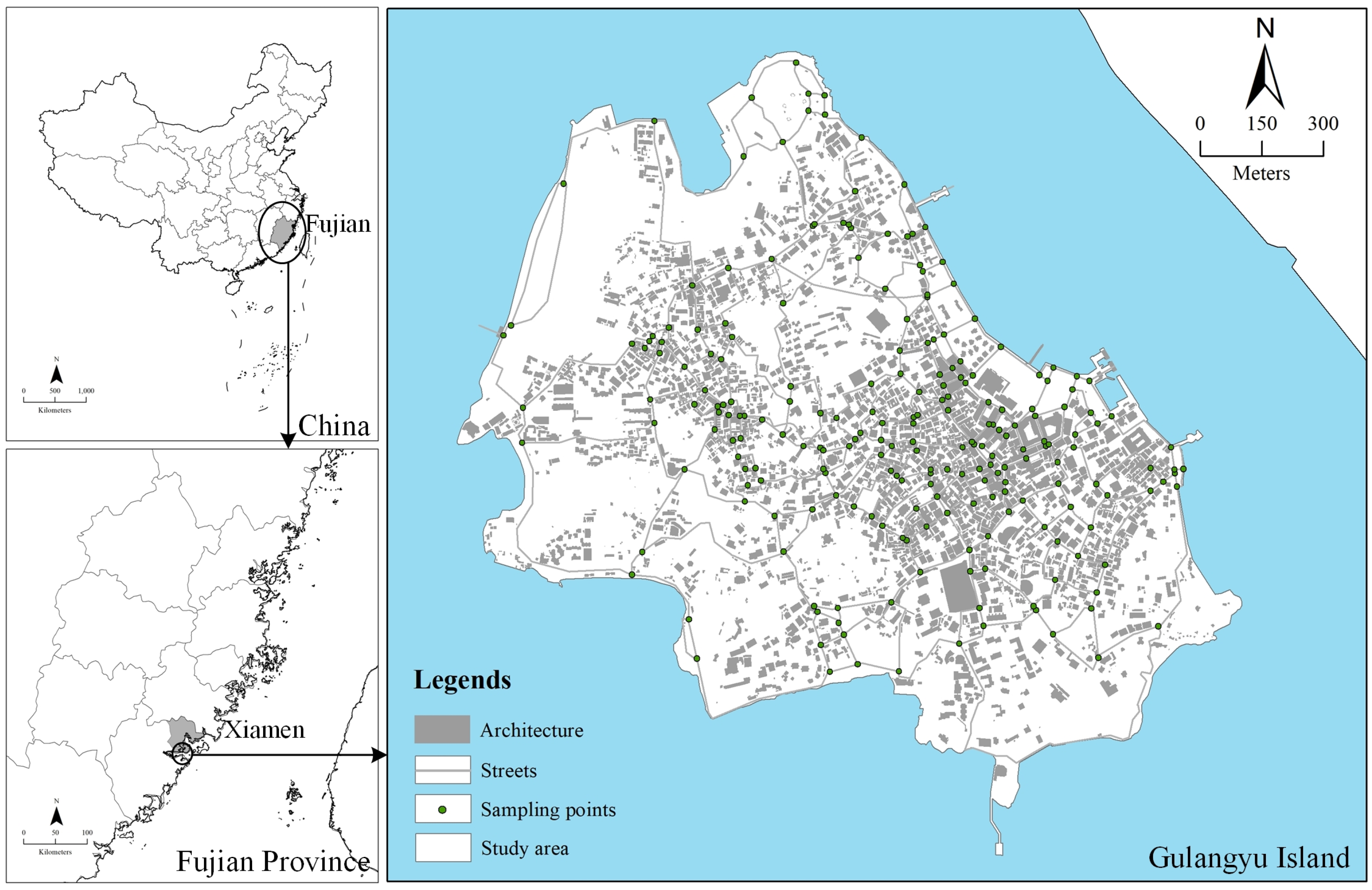
2.1. Study Area
2.2. Research Framework
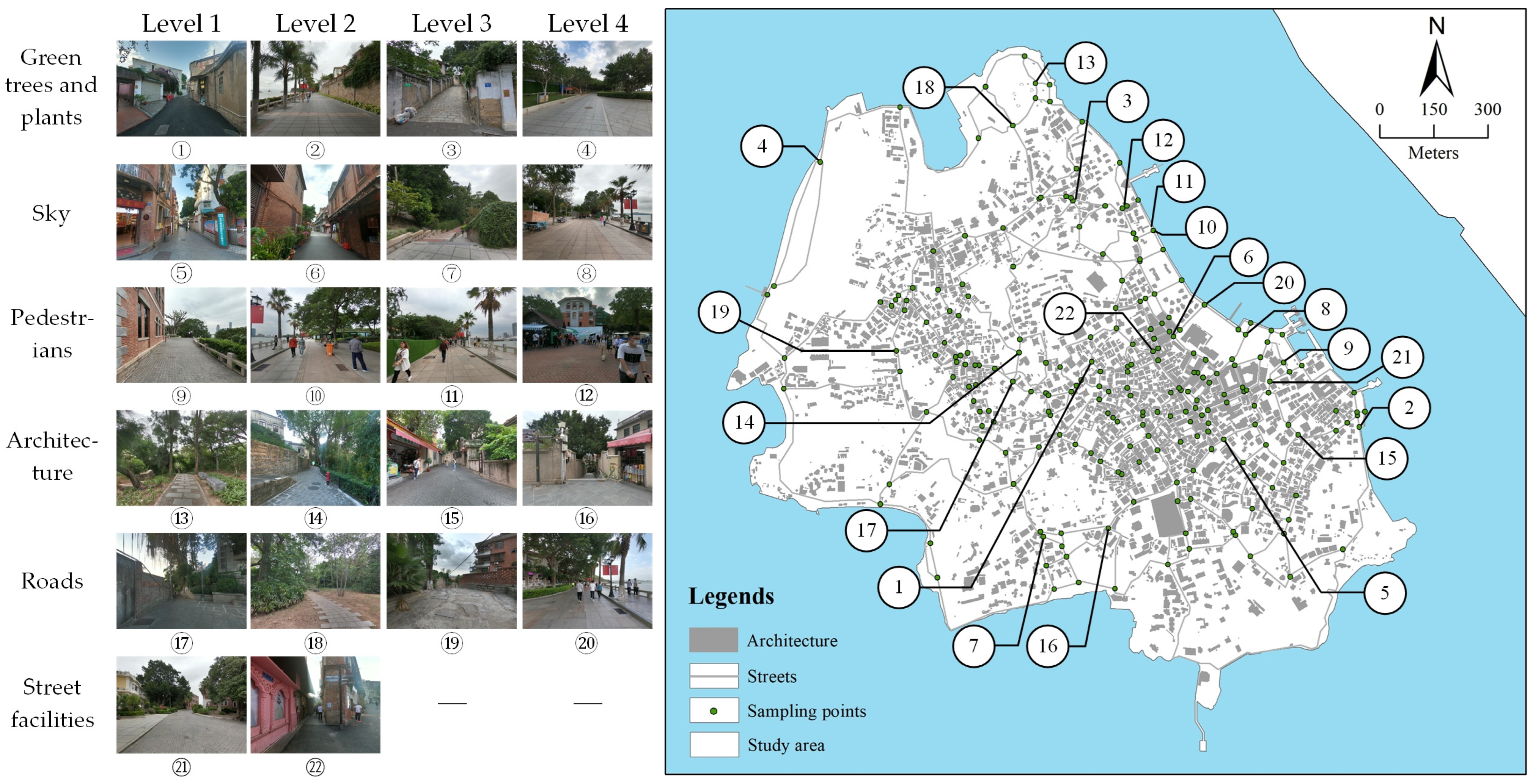
2.3. Data Collection and Processing
- (1)
- The GVI describes the proportion of green trees and plants in the visual fields from Aoki [42]. Scholars have emphasized the critical role of green plants in measuring visual perception and considered them a catalyst for pedestrian activities [43]. According to Li, et al. [44], the GVI can be classified into five levels: very low (<0.05), low (0.05–0.15), medium (0.15–0.25), high (0.25–0.35), and very high (>0.35). Accordingly, the GVI is divided into four thresholds: 0.05, 0.15, 0.25, and 0.35.
- (2)
- The sky, pedestrians, architecture (including walls), and roads are related to tourists’ visual perception. They are also connected with the indicators such as sky openness and enclosure [45,46]. However, there is no specific threshold for the proportion of the visual features above to affect an individual’s visual perception or measure the degree of pleasure they produce. Moreover, there are street intersections with no architecture and no pedestrians in Gulangyu; the first level can be selected as zero. As for other features, the authors use the value of the lower quartiles and the median and the upper quartiles of each visual feature as measured results to divide each level according to the field survey.
- (3)
- The proportion of street facilities in the visual field is generally low. Due to the difference in accuracy, the segmentation results of street facilities may fluctuate. Therefore, various street facilities are combined into one feature and participate in a preference survey. In detail, the value of the upper quartiles, the lower quartiles, and the median quartiles of the street facilities are similar; hence, the authors divided them into two levels in this survey.
3. Results
3.1. Fitting Results Analysis
3.2. Typical Intersection Analysis
4. Discussion
4.1. Main Findings
4.2. Implications for Optimization of Street Space Design
- (1)
- Selective use of green plants, combining continuous and vertical design. From the perspective of green plants in street spaces, the higher GVI positively impacts tourists’ visual perception. Therefore, different levels of green plants or designs can be used at street intersections where tourism routes pass to enhance visual perception or strengthen direction guidance. Generally, there are two types of areas on both sides of the street space in Gulangyu: bare land and hard pavement. For example, for bare land, designers can use trees and shrubs to strengthen the continuity of green plants for landscaping. For the hard pavement, managers can use greening sketches with shrubs, herbs, or ground cover plants, combined with rest facilities at fixed modulus intervals on both sides to improve visual perception. More green plants can improve tourists’ visual perception to some extent, but too high of a GVI will also negatively affect perceptions due to reduced sky openness and increased enclosure. Therefore, if the designers use trees and shrubs for landscaping, trees with large crowns should not be used in the street environment that needs to be improved. Moreover, if there are buildings, walls, or structures on both sides of the street, climbing plants with landscape decorations or vertical greening designs can be considered. They ensure the optimization measures increase not only the GVI but also avoid the excessive improvement of the enclosure reducing the visual utility.
- (2)
- Adjusting the visual features in a targeted manner and unifying multi-features coordination with multi-department cooperation. For example, the enclosure is related to the architecture, green plants, and roads at street intersections. Among them, the changes in architecture are often restricted due to the cultural heritage protection requirement; therefore, green plants and roads can regulate the features affecting the enclosure. Meanwhile, managers can also clean the sundries on the road or wall surface to optimize the enclosure. Specifically, the streets’ boundaries can be strengthened and limited by closely arranged green pieces, plant sequences, or by the design and adjustment of structures. The optimization and adjustment of the enclosure need to be considered and designed as a unified whole. Furthermore, different visual features belong to different management authorities, so coordinating their cooperation is necessary.
- (3)
- Control the whole function layout of street space and coordinate functional integration and multi-intersection promotion. For variety, designers can lay street facilities out in combination with the main functions of the streets. Optimizing the environment can be designed through the flexible use of environmental sketches and facilities such as advertising signs, lighting equipment, garbage bins, landscape sketches, rest facilities, sculptures, and guide cards, to enrich the tourists’ activities and beautify the street to some extent. In addition, managers can control the whole design, placement, construction, and maintenance process, based on the landscape’s integrity. A street facility has limited influence on tourists’ vision. However, a designed sign system can reflect the cultural characteristics of tourist destinations and can be developed to attract tourists’ attention and further optimize the surrounding landscape features. In addition, managers should build a multidisciplinary platform of integrate planning and collaborative adjustment to optimize and refine the visual perception of the environment and improve the sustainable development pattern.
5. Conclusions and Limitations
Author Contributions
Funding
Institutional Review Board Statement
Informed Consent Statement
Data Availability Statement
Conflicts of Interest
Abbreviation
References
- Zhu, X.; Yoshikawa, A.; Qiu, L.; Lu, Z.; Lee, C.; Ory, M. Healthy workplaces, active employees: A systematic literature review on impacts of workplace environments on employees’ physical activity and sedentary behavior. Build. Environ. 2020, 168, 106455. [Google Scholar] [CrossRef]
- Collyer, C.; Bell, M.F.; Christian, H.E. Associations between the built environment and emotional, social and physical indicators of early child development across high and low socioeconomic neighbourhoods. Int. J. Hyg. Environ. Health 2022, 243, 113974. [Google Scholar] [CrossRef] [PubMed]
- Yu, Y.; Jiang, Y.; Qiu, N.; Guo, H.; Han, X.; Guo, Y. Exploring built environment factors on e-bike travel behavior in urban China: A case study of Jinan. Front. Public Health 2022, 10, 1013421. [Google Scholar] [CrossRef] [PubMed]
- Zhan, D.; Zhang, Q.; Kwan, M.-P.; Liu, J.; Zhan, B.; Zhang, W. Impact of urban green space on self-rated health: Evidence from Beijing. Front. Public Health 2022, 10, 3025. [Google Scholar] [CrossRef]
- Yang, L.; Yu, B.; Liang, Y.; Lu, Y.; Li, W. Time-varying and non-linear associations between metro ridership and the built environment. Tunn. Undergr. Space Technol. 2023, 132, 104931. [Google Scholar] [CrossRef]
- Sallis, J.F.; Cerin, E.; Conway, T.L.; Adams, M.A.; Frank, L.D.; Pratt, M.; Salvo, D.; Schipperijn, J.; Smith, G.; Cain, K.L.; et al. Physical activity in relation to urban environments in 14 cities worldwide: A cross-sectional study. Lancet 2016, 387, 2207–2217. [Google Scholar] [CrossRef]
- Yang, L.; Liang, Y.; He, B.; Lu, Y.; Gou, Z. COVID-19 effects on property markets: The pandemic decreases the implicit price of metro accessibility. Tunn. Undergr. Space Technol. 2022, 125, 104528. [Google Scholar] [CrossRef]
- Yang, L.; Liang, Y.; He, B.; Yang, H.; Lin, D. COVID-19 moderates the association between to-metro and by-metro accessibility and house prices. Transp. Res. Part D Transp. Environ. 2023, 114, 103571. [Google Scholar] [CrossRef]
- Pigliautile, I.; Casaccia, S.; Morresi, N.; Arnesano, M.; Pisello, A.L.; Revel, G.M. Assessing occupants’ personal attributes in relation to human perception of environmental comfort: Measurement procedure and data analysis. Build. Environ. 2020, 177, 106901. [Google Scholar] [CrossRef]
- de Looze, M.P.; Kuijt-Evers, L.F.; van Dieën, J. Sitting comfort and discomfort and the relationships with objective measures. Ergonomics 2003, 46, 985–997. [Google Scholar] [CrossRef]
- Slater, K. Discussion paper the assessment of comfort. J. Text. Inst. 1986, 77, 157–171. [Google Scholar] [CrossRef]
- Van Cauwenberg, J.; Mertens, L.; Petrovic, M.; Van Dyck, D.; Deforche, B. Relations of the neighbourhood socio-economic and physical environment with 3-year changes in health-related quality of life among community-dwelling older adults in Belgium. Cities 2022, 128, 103732. [Google Scholar] [CrossRef]
- Miller, P.; Liu, B.; Tang, Z. Visual preference research: An approach to understanding landscape perception. Chin. Landsc. Archit. 2013, 29, 22–26. (In Chinese) [Google Scholar]
- Kaplan, R. The analysis of perception via preference: A strategy for studying how the environment is experienced. Landsc. Plan. 1985, 12, 161–176. [Google Scholar] [CrossRef]
- Rentschler, I.; Jüttner, M.; Unzicker, A.; Landis, T. Innate and learned components of human visual preference. Curr. Biol. 1999, 9, 665–671. [Google Scholar] [CrossRef]
- Masahiro, T.; Toshikazu, K. Visual KANSEI Modeling Based on Focal Area Analysis and Hierarchical Classification. Trans. Inst. Electron. Inf. Commun. Eng. 2004, 87, 1983–1995. (In Japanese) [Google Scholar]
- Li, Y.; Yabuki, N.; Fukuda, T. Measuring visual walkability perception using panoramic street view images, virtual reality, and deep learning. Sustain. Cities Soc. 2022, 86, 104140. [Google Scholar] [CrossRef]
- Lothian, A. Landscape and the philosophy of aesthetics: Is landscape quality inherent in the landscape or in the eye of the beholder? Landsc. Urban Plan. 1999, 44, 177–198. [Google Scholar] [CrossRef]
- Gao, W.; Qian, Y.; Chen, H.; Zhong, Z.; Zhou, M.; Aminpour, F. Assessment of sidewalk walkability: Integrating objective and subjective measures of identical context-based sidewalk features. Sustain. Cities Soc. 2022, 87, 104142. [Google Scholar] [CrossRef]
- Linwei, H.; Longyu, S.; Fengmei, Y.; Xue-qin, X.; Lijie, G. Method for the evaluation of residents’ perceptions of their community based on landsenses ecology. J. Clean. Prod. 2021, 281, 124048. [Google Scholar] [CrossRef]
- Ma, X.; Ma, C.; Wu, C.; Xi, Y.; Yang, R.; Peng, N.; Zhang, C.; Ren, F. Measuring human perceptions of streetscapes to better inform urban renewal: A perspective of scene semantic parsing. Cities 2021, 110, 103086. [Google Scholar] [CrossRef]
- Wang, L.; Han, X.; He, J.; Jung, T. Measuring residents’ perceptions of city streets to inform better street planning through deep learning and space syntax. ISPRS J. Photogramm. Remote Sens. 2022, 190, 215–230. [Google Scholar] [CrossRef]
- Wang, R.; Zhao, J.; Liu, Z. Consensus in visual preferences: The effects of aesthetic quality and landscape types. Urban For. Urban Green. 2016, 20, 210–217. [Google Scholar] [CrossRef]
- Liu, Y.; Hu, M.; Zhao, B. Audio-visual interactive evaluation of the forest landscape based on eye-tracking experiments. Urban For. Urban Green. 2019, 46, 126476. [Google Scholar] [CrossRef]
- Blečić, I.; Cecchini, A.; Trunfio, G.A. Towards Automatic Assessment of Perceived Walkability. In Proceedings of the International Conference on Computational Science and Its Applications—ICCSA 2018, Melbourne, VIC, Australia, 2–5 July 2018; Gervasi, O., Murgante, B., Misra, S., Stankova, E., Torre, C.M., Rocha, A.M.A.C., Taniar, D., Apduhan, B.O., Tarantino, E., Ryu, Y., Eds.; Springer International Publishing: Cham, Switzerland, 2018; pp. 351–365. [Google Scholar]
- Badrinarayanan, V.; Kendall, A.; Cipolla, R. SegNet: A Deep Convolutional Encoder-Decoder Architecture for Image Segmentation. IEEE Trans. Pattern Anal. Mach. Intell. 2017, 39, 2481–2495. [Google Scholar] [CrossRef]
- Ye, Y.; Zeng, W.; Shen, Q.; Zhang, X.; Lu, Y. The visual quality of streets: A human-centred continuous measurement based on machine learning algorithms and street view images. Environ. Plan. B Urban Anal. City Sci. 2019, 46, 1439–1457. [Google Scholar] [CrossRef]
- Long, J.; Shelhamer, E.; Darrell, T. Fully convolutional networks for semantic segmentation. In Proceedings of the IEEE Conference on Computer Vision and Pattern Recognition, Boston, MA, USA, 7–12 June 2015; pp. 3431–3440. [Google Scholar]
- Liu, J.; Wei, Y.; Lu, S.; Wang, R.; Chen, L.; Xu, F. The elderly’s preference for the outdoor environment in Fragrant Hills Nursing Home, Beijing: Interpreting the visual-behavioural relationship. Urban For. Urban Green. 2021, 64, 127242. [Google Scholar] [CrossRef]
- Goličnik, B.; Ward Thompson, C. Emerging relationships between design and use of urban park spaces. Landsc. Urban Plan. 2010, 94, 38–53. [Google Scholar] [CrossRef]
- Sun, Y.; Zhao, X.; Wang, Y.; Li, F.; Li, X. Study on the visual evaluation preference of rural landscape based on VR panorama. J. Beijing For. Univ. 2016, 38, 104–112. (In Chinese) [Google Scholar]
- Vondolia, G.K.; Hynes, S.; Armstrong, C.W.; Chen, W. Subjective well-being and stated preferences: Explorations from a choice experiment in Norway. J. Behav. Exp. Econ. 2021, 91, 101682. [Google Scholar] [CrossRef]
- Ben-Akiva, M.; Lerman, S.R. Discrete Choice Analysis: Theory and Application to Travel Demand; MIT Press: Cambridge, MA, USA, 1985. [Google Scholar]
- Xu, C.; Witlox, F. Understanding total evacuation time perception in airplane emergency: A stated preference approach. Saf. Sci. 2022, 146, 105540. [Google Scholar] [CrossRef]
- Häfner, K.; Zasada, I.; van Zanten, B.T.; Ungaro, F.; Koetse, M.; Piorr, A. Assessing landscape preferences: A visual choice experiment in the agricultural region of Märkische Schweiz, Germany. Landsc. Res. 2018, 43, 846–861. [Google Scholar] [CrossRef]
- Li, Y.; Huang, J.; Yang, L. From Functional Space to Experience Space: Applying space syntax analysis to a museum in China. Int. Rev. Spat. Plan. Sustain. Dev. 2020, 8, 86–99. [Google Scholar] [CrossRef] [PubMed]
- Li, Y.; Huang, J.; Liang, J.; Zhang, Y.; Chen, Y. Research on visual attraction and influencing factors of perception of commercial street space in cultural heritage site: Taking Gulangyu Longtou Road as an Example. J. Hum. Settl. West China 2022, 37, 114–121. (in Chinese). [Google Scholar]
- Yao, Y.; Liang, Z.; Yuan, Z.; Liu, P.; Bie, Y.; Zhang, J.; Wang, R.; Wang, J.; Guan, Q. A human-machine adversarial scoring framework for urban perception assessment using street-view images. Int. J. Geogr. Inf. Sci. 2019, 33, 2363–2384. [Google Scholar] [CrossRef]
- McFadden, D. Conditional logit analysis of qualitative choice behavior. In Frontiers in Econometrics; Zarembka, P., Ed.; Academic Press: New York, NY, USA, 1974; pp. 105–142. [Google Scholar]
- Yang, L.; Tang, X.; Yang, H.; Meng, F.; Liu, J. Using a system of equations to assess the determinants of the walking behavior of older adults. Trans. GIS 2022, 26, 1339–1354. [Google Scholar] [CrossRef]
- Huang, J.; Liang, J.; Yang, M.; Li, Y. Street space visual quality evaluating method of tourism sites based on street view images. J. Geo-Inf. Sci. 2022, 24, 1–15. (In Chinese) [Google Scholar] [CrossRef]
- Aoki, Y. Relationship between percieved greenery and width of visual fields. J. Jpn. Inst. Landsc. Archit. 1987, 51, 1–10. (In Japanese) [Google Scholar]
- Li, X.; Zhang, C.; Li, W.; Kuzovkina, Y.A. Environmental inequities in terms of different types of urban greenery in Hartford, Connecticut. Urban For. Urban Green. 2016, 18, 163–172. [Google Scholar] [CrossRef]
- Li, T.; Zheng, X.; Wu, J.; Zhang, Y.; Fu, X.; Deng, H. Spatial relationship between green view index and normalized differential vegetation index within the Sixth Ring Road of Beijing. Urban For. Urban Green. 2021, 62, 127153. [Google Scholar] [CrossRef]
- Zhou, H.; He, S.; Cai, Y.; Wang, M.; Su, S. Social inequalities in neighborhood visual walkability: Using street view imagery and deep learning technologies to facilitate healthy city planning. Sustain. Cities Soc. 2019, 50, 101605. [Google Scholar] [CrossRef]
- Yin, L.; Wang, Z. Measuring visual enclosure for street walkability: Using machine learning algorithms and Google Street View imagery. Appl. Geogr. 2016, 76, 147–153. [Google Scholar] [CrossRef]
- Boeing, G. Measuring the complexity of urban form and design. Urban Des. Int. 2018, 23, 281–292. [Google Scholar] [CrossRef]
- Im, H.N.; Choi, C.G. The hidden side of the entropy-based land-use mix index: Clarifying the relationship between pedestrian volume and land-use mix. Urban Stud. 2018, 56, 1865–1881. [Google Scholar] [CrossRef]
- Ernawati, J.; Adhitama, M.S.; Surjono; Sudarmo, B.S. Urban Design Qualities Related Walkability in a Commercial Neighbourhood. Environ. Behav. Proc. J. 2016, 1, 242–250. [Google Scholar] [CrossRef]
- Ernawati, J.; Surjono; Sudarmo, B.S. People’s Preferences of Urban Design Qualities for Walking on a Commercial Street. IOP Conf. Ser. Earth Environ. Sci. 2018, 126, 012206. [Google Scholar] [CrossRef]
- Li, Y.; Wang, X.; Huang, C. Key street tree species selection in urban areas. Afr. J. Agric. Res. 2011, 6, 3539–3550. [Google Scholar]
- Sæbø, A.; Borzan, Ž.; Ducatillion, C.; Hatzistathis, A.; Lagerström, T.; Supuka, J.; García-Valdecantos, J.L.; Rego, F.; Van Slycken, J. The Selection of Plant Materials for Street Trees, Park Trees and Urban Woodland. In Urban Forests and Trees: A Reference Book; Konijnendijk, C., Nilsson, K., Randrup, T., Schipperijn, J., Eds.; Springer: Berlin/Heidelberg, Germany, 2005; pp. 257–280. [Google Scholar]
- Roy, S. Anomalies in Australian municipal tree managers’ street-tree planting and species selection principles. Urban For. Urban Green. 2017, 24, 125–133. [Google Scholar] [CrossRef]
- Kim, S.S.; Lee, J.-S.; Lee, D.H.; Choi, Y. Citizens’ Preference and Perception of Street Trees of Main Boulevards in Busan, South Korea. Sustainability 2021, 13, 3141. [Google Scholar] [CrossRef]
- Manning, R.E.; Valliere, W.A.; Wang, B. Crowding Norms: Alternative Measurement Approaches. Leis. Sci. 1999, 21, 97–115. [Google Scholar]
- Collado, S.; Staats, H.; Sorrel, M.A. A relational model of perceived restorativeness: Intertwined effects of obligations, familiarity, security and parental supervision. J. Environ. Psychol. 2016, 48, 24–32. [Google Scholar] [CrossRef]
- Coleman, A.F.; Ryan, R.L.; Eisenman, T.S.; Locke, D.H.; Harper, R.W. The influence of street trees on pedestrian perceptions of safety: Results from environmental justice areas of Massachusetts, U.S. Urban For. Urban Green. 2021, 64, 127258. [Google Scholar] [CrossRef]


| Visual Indicators | Features | Formula |
|---|---|---|
| Green View Index | Green trees and plants | |
| Sky Openness | The sky | |
| Crowdedness | Pedestrians | |
| Enclosure | Architecture, walls, green trees and plants, and roads | |
| Variety | Street facilities |
| Visual Features | Levels | |||
|---|---|---|---|---|
| Level 1 | Level 2 | Level 3 | Level 4 | |
| Green trees and plants | 0.05 | 0.15 | 0.25 | 0.35 |
| The sky | 0.05 | 0.10 | 0.15 | 0.20 |
| Pedestrians | 0.00 | 0.05 | 0.10 | 0.15 |
| Architecture | 0.00 | 0.15 | 0.25 | 0.35 |
| Roads | 0.20 | 0.25 | 0.30 | 0.35 |
| Street facilities | 0.00 | 0.05 | — | — |
| Attributes | Count | Percentage/% | |
|---|---|---|---|
| Gender | Male | 116 | 48.33 |
| Female | 124 | 51.67 | |
| Age | Below 18 | 6 | 2.50 |
| 18–34 | 178 | 74.17 | |
| 35–60 | 48 | 20.00 | |
| Above 60 | 8 | 3.33 | |
| Education | Primary | 1 | 0.42 |
| Junior | 10 | 4.17 | |
| Senior | 28 | 11.67 | |
| High vocation\Undergraduate | 140 | 58.33 | |
| Above graduate | 61 | 25.42 | |
| Visual Features | Coefficient | Z | P |
|---|---|---|---|
| Green view index | 107.3453 | 8.57 | 0.000 |
| Sky openness | 52.8163 | 8.87 | 0.000 |
| Crowdedness | −103.7304 | −8.29 | 0.000 |
| Enclosure | −11.3134 | −8.32 | 0.000 |
| Variety | 123.0995 | 8.55 | 0.000 |
| Log likelihood | −823.1502 | ||
| Prob > chi2 | 0.0000 | ||
| Pseudo R2 | 0.1444 | ||
Disclaimer/Publisher’s Note: The statements, opinions and data contained in all publications are solely those of the individual author(s) and contributor(s) and not of MDPI and/or the editor(s). MDPI and/or the editor(s) disclaim responsibility for any injury to people or property resulting from any ideas, methods, instructions or products referred to in the content. |
© 2022 by the authors. Licensee MDPI, Basel, Switzerland. This article is an open access article distributed under the terms and conditions of the Creative Commons Attribution (CC BY) license (https://creativecommons.org/licenses/by/4.0/).
Share and Cite
Huang, J.; Liang, J.; Yang, M.; Li, Y. Visual Preference Analysis and Planning Responses Based on Street View Images: A Case Study of Gulangyu Island, China. Land 2023, 12, 129. https://doi.org/10.3390/land12010129
Huang J, Liang J, Yang M, Li Y. Visual Preference Analysis and Planning Responses Based on Street View Images: A Case Study of Gulangyu Island, China. Land. 2023; 12(1):129. https://doi.org/10.3390/land12010129
Chicago/Turabian StyleHuang, Jingxiong, Jiaqi Liang, Mengsheng Yang, and Yuan Li. 2023. "Visual Preference Analysis and Planning Responses Based on Street View Images: A Case Study of Gulangyu Island, China" Land 12, no. 1: 129. https://doi.org/10.3390/land12010129
APA StyleHuang, J., Liang, J., Yang, M., & Li, Y. (2023). Visual Preference Analysis and Planning Responses Based on Street View Images: A Case Study of Gulangyu Island, China. Land, 12(1), 129. https://doi.org/10.3390/land12010129