Abstract
With increasing urbanisation, understanding the variety of historical experience with water in the urban context becomes all the more relevant. Apart from representing an economic and environmental necessity, the physical and sensory access to freshwater is universally understood as socially desirable, pleasing and valued. The history of the East African coast is especially relevant as water scarcity is not a modern phenomenon in the region—in fact, precolonial towns situated on the oceanfront flourished in relatively arid environments too. This paper presents the insights achieved with a 3D scanning survey of the preserved heritage in the now-deserted town of Jumba la Mtwana, located 20 km north of Mombasa, Kenya. Although all of the buildings are partially collapsed, various wells, cisterns and reservoirs have been documented. Considering this archaeological site and other examples of (pre)colonial Swahili towns, this paper adopts multidisciplinary perspectives in analysing and interpreting the distribution of constructed features associated with water, with particular focus on their design, density and spatial context, as well as social and sensory connotations. Its results highlight the socio-spatial role of the element of water in the precolonial built environment, which may be contrasted with later periods and potentially carry broader implications for current urban development.
Keywords:
Swahili; precolonial urbanism; archaeology; water management; wells; sensory perception; Kenya; coast 1. Introduction
The East African coast is a region with more than a millennium of urban history. The Swahili coast, as it is also known, is represented by a strip of land only a few kilometers wide, but extending over approximately 3000 km from what is today Somalia, Kenya, and Tanzania, to Mozambique and northern Madagascar, and incorporating multiple islands distributed close to the coastline. The past trajectory of Swahili urban development has been studied from historical, archaeological and ethnographic perspectives, which revealed that urbanism in the area has been associated with cultural features shared across the region since the precolonial period and reflected in the locally characteristic architectural style, religious practices, and economy. Albeit undergoing change over time and influenced by colonialism, a characteristic level of coherence was maintained along the coast. One of the factors that repeatedly arise in Swahili cultural history anywhere in the region is the management of and references to the element of water. While drawing on resources provided by the proximity of the ocean, access to a sufficient supply of clean freshwater has been notoriously problematic in the coastal towns and in many, such as Zanzibar, it has become all the more complex today after the period of haphazard colonial development [1,2].
When recognising the effects of colonialism, it also needs to be derived that a long-term understanding of the role water played in the urban context can only be gained through including the precolonial period in the picture. Such understanding needs to be based on the material evidence from the now deserted settlements, where archaeological enquiry provides insights into the urban settlement dynamics between the 8th and 16th century CE. For Swahili archaeology, supplying precolonial towns with freshwater became of interest relatively early on, when the first excavations on the coast were conducted in the 1950s [3]. It was noted that Swahili precolonial towns, even though some were occupied only for a few generations, featured multiple wells and cisterns, which provided the urban society with freshwater, even though these may not always have been in simultaneous use [4]. The dominant reason behind the abandonment of settlements, which is seen on many sites in the 14th and again in the 16th century, was identified in the drying up of wells or in their increased salinity [5,6].
Since these early interpretations, the study of features associated with water in the Swahili urban context has not been systematic. However, the amount of research into the role of water on the coast grew significantly in the last three decades and it was studied in more depth on some sites, especially at Gede, Kenya and Songo Mnara, Tanzania [7], as part of the broader recognition in the field of archaeological research that environmental factors widely affected and shaped social histories and transformations [8,9]. The practices of water management have remained the best-explored aspects in considerations of water in the urban context. For example, it has been argued that water was used for the regular cleaning of floors [10], that it was necessary in large quantities for construction with the traditional technology using lime mortar and plastering, or that in towns with few wells such as Songo Mnara in Tanzania, access to freshwater was supplemented by rainwater collected in cisterns [7].
The element of water, however, permeated all aspects of urban life in Swahili towns. As the distribution of Swahili settlements was selectively limited to the oceanfront, with a number of structures built directly on the beach, the ocean surely played a paramount role for the local economy. Specifically, it was significant in terms of providing subsistence, with opportunities for fishing and the exploitation of marine resources, as well as representing a major communication link for the trade networks which ran along the East African coast, along the rim of the Indian Ocean, and which reached as far as India and China [11]. On the oceanfront, access to freshwater must have involved significant planning, as the concentrations of people facilitating the rise of urbanism made it a paramount concern in the arid environment where freshwater sources were scarce [1]. Furthermore, Islam, which became a dominant religion on the coast at the late 11th century CE, is associated with a number of daily practices of cleansing and purity that involved water [12]. These factors, regardless of whether they were practical or symbolic, were represented by structures built of stone associated with water, which in turn set the scene for a locally specific type of social interaction and shaped the urban environment.
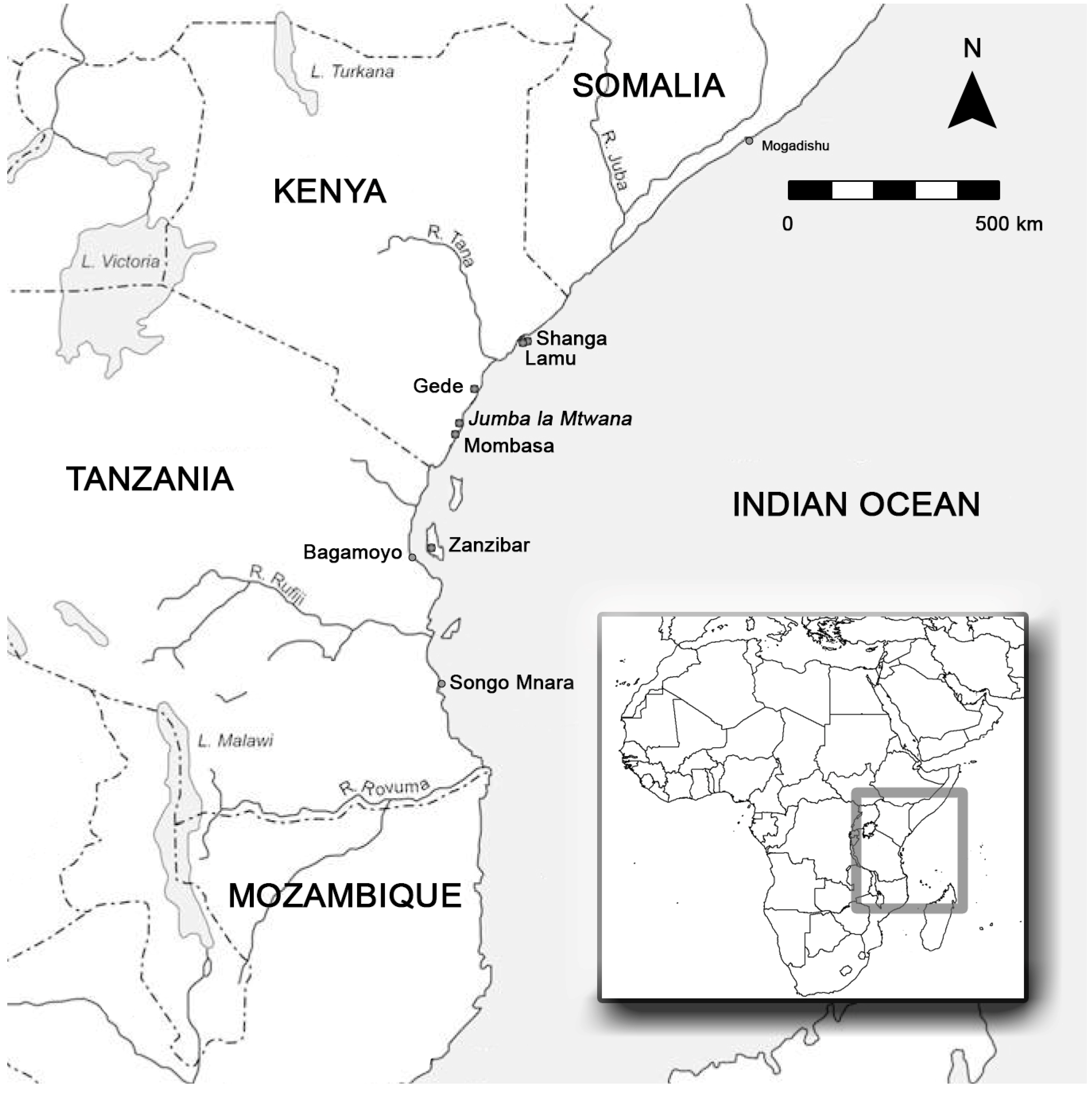
It may be derived that it is not only the practical concern of water management that needs to be considered for an inclusive understanding of precolonial urbanity on the Swahili coast, but rather the complex picture of how the element was interwoven into the fabric of daily life. Building on a longer tradition of concepts established by Lefebvre [13], Haug and Müller identified levels on which the element of water may be understood to encompass its many roles in urban space through practices, perception, architectural features, infrastructure, mental conceptualisation and as a frontier of interaction with the environment [14] (p. 4). Following up on this argument, this paper considers water in the precolonial Swahili urban context from a variety of perspectives, while incorporating natural and social environmental aspects, as well as evidence for past sensory experiences associated with water. It therefore bridges the gaps between the disciplines of archaeology, anthropology, history and urban studies. The multiple aspects are assessed in the case study of Jumba la Mtwana, a precolonial town in present-day Kenya (Figure 1), considering the evidence in the architectural environment of the now-deserted site. Thanks to a relatively good preservation of the stone-built structures on site, including features associated with water, Jumba la Mtwana represent a very good example for the study of the role and use of water in the precolonial past. Furthermore, the continuity of settlement in the close vicinity of Jumba la Mtwana allows a comparison with the present-day urban context to be made. The resulting picture of the roles that water played in the precolonial town links the practical and the aesthetic aspects, and brings an enhanced understanding of the past strategies adopted in situating and distributing water in the urban built environment. Today, with the increasing focus on sustainability and the effect of human practices on the one hand and the enhanced aesthetic and cultural quality of urban life on the other [15], precolonial Africa provides a valuable reflection of how these factors were intertwined in context with water in an arid coastal environment.
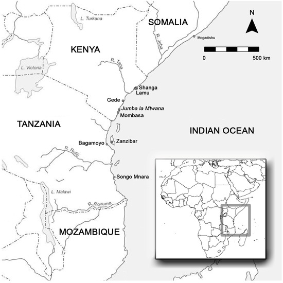
Figure 1.
The map shows the location of the precolonial town of Jumba la Mtwana and other towns mentioned in the text.
2. Constructed Features Associated with Water and Methods of Analysis
Many of the present-day coastal towns in East Africa were founded in the colonial era. However, the majority of data on the history of urbanism dates to the precolonial period, represented by deserted towns which are now preserved as archaeological sites. For most of Swahili urban history, the material culture is the main data resource, with a unique capacity to cover its entire breadth. The deserted towns are characterised above ground by the remains of stone architecture built from coral rag, a locally accessible type of limestone. Among these, the features associated with the element of water are amongst the most numerous, and include various types of wells, conduits, reservoirs and cisterns.
2.1. The Site of Jumba la Mtwana and Its Natural Environment
The site of Jumba la Mtwana is an example of such a precolonial town. It was occupied between the 14th and the 16th century, based on pottery sequences from excavations in the 1970s [16] and architectural surveys conducted between 1960–1980s [17,18]. The town is located in the south of Kenya, about 15 km north of Mombasa (Figure 1). The site is in a tropical woodland that characterises most of the Kenyan waterfront. In terms of water resources, the main characteristics of the present-day natural environment on the coast have not changed much in over the last millennium [19]. Nearby Mombasa may therefore serve as a good comparison for the town of Jumba la Mtwana. In Mombasa, access to freshwater presents a serious problem today, and the supply of groundwater is supplemented by freshwater from rain, especially in the rainy seasons between April and July and October to December, when rainfall oscillates between 100–135 mm monthly on average [20]. Ethnographically, there is evidence that in this relatively arid environment it has been a common practice since the colonial era to depend on a number of wells situated across the towns [21], and on rainfall collected in open containers, which both provide freshwater. There is also historical evidence of this, for example in colonial Bagamoyo, Tanzania [22]. Various water reservoirs are still built with bowls inset in the bottom, which are used to collect settling mud and keep the water clean [23] (p. 146), and evidence from multiple archaeological sites confirms that this solution was already used in the precolonial period.
2.2. Social Context
The association of the built environment with access to water has been mirrored in social practices too. Freshwater was needed for personal hygiene and sanitation, which has been of great importance in Swahili towns throughout history. In precolonial towns, evidence of interior toilets and sometimes bathrooms as small rooms dedicated to personal cleanliness is abundant along the coast, and Jumba la Mtwana is no exception. Historical evidence confirms the continued accent on cleanliness in context with residential housing [24]. In present-day Swahili towns, wells may be found in house courtyards for private use.
In open spaces, wells are publicly accessible. Meeting and holding conversations by the wells continue to represent an important part of the social environment [22]. Access to water in wells also entered the local folklore, such as in the belief in well-charms, which could make water poisonous to enemies but not owners of the well [23] (p. 139). Customs such as these confirm that different categories of private and public wells are distinguished and could have been recognised in the past. Wells as public spaces were often associated with other public structures, most importantly mosques. Apart from serving as meeting spaces, these also represented the public face of the town, as mosques were some of the most monumental buildings, and in many precolonial towns they were constructed on the waterfront and visible from the sea. Freshwater itself was an important commodity in the context of construction, as access to larger quantities of water was needed for washing salt out of lime for producing building material [7]. In colonial Zanzibar, trade with water was most commonly associated with women, who were employed as water carriers and sellers [2] (pp. 49–50), while men worked as builders.
2.3. Sensory Environment
Sensory perception has come to be understood to be a crucial part of lived experience in the study of both past and present day urbanism [25,26], while it is beginning to be considered in the Islamic context [27]. Multiple studies suggest that sensory perception played an important part in Swahili society from the precolonial to later periods. As for vision, valuable items were displayed in visible places in Swahili households, especially in niches inside the houses positioned in the line of sight [28,29], or in the exterior, inset in tall pillars which dominated some stone tombs and made them visible over buildings and town walls [30]. Visual aspect hence played a role in showing social standing, access to trade networks and to items obtained from long-distance trade [31] (p. 53), or as charms for protection against evil [23] (p. 169). The courtyards of stone houses, as important interior meeting spaces, were architecturally dominated by wells. Haptic perception also played a part in daily experience, especially associated with movement and the curation of access routes, gates and thresholds in precolonial towns. In the context of water, walking through the shallows of water canals represented one of the most common short-distance communication routes, especially in towns and villages on islands [32]. In terms of auditory perception, precolonial Swahili towns manifested a tendency to be located close to the waterfront, which also meant maintaining an auditory link with the ocean, as shown by the previous research of the author [33]. Although the specific nature of sensory experience changed over time, it is clear that sensory experience was associated with the context of water and formed part of everyday urban life in Swahili towns.
2.4. Survey Methodology
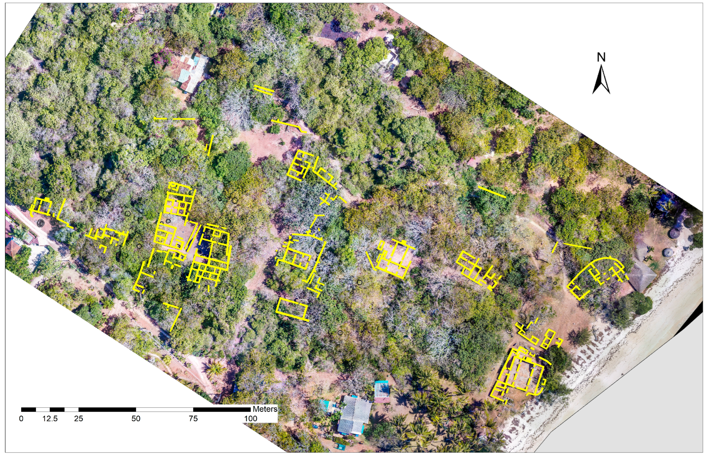
The multiple aspects of how water was incorporated into the built Swahili environment were studied using a survey of the preserved built environment in the precolonial town of Jumba la Mtwana, whose results were then subjected to analysis. The deserted town was studied in a project of the author in 2021 using a detailed architectural survey, whose main component was 3D scanning complemented with some (drone) photography. The site has approximately 3 ha today, but it is certain that the town does not preserve in its original dimensions. The site is located directly on the seafront, with modern buildings encroaching from two sides towards the historic town, and with a densely overgrown area from the northeast. The preserved extent of the site is now protected and open to the public. The buildings of the town are distributed along the beach and about 300 m inland (Figure 2). While some of the most monumental buildings are located directly on the beach, a large part of the site is positioned on a slightly elevated ground overlooking the beach and offering views of the ocean and towards the outcrop on which the old port of Mombasa is located. Similarly to other precolonial towns on the Swahili coast, the abandonment of Jumba la Mtwana in the 16th century has been attributed to the salinisation or drying up of wells [5]. Nevertheless, modern buildings draw water from wells, which are located a short distance away from the site.
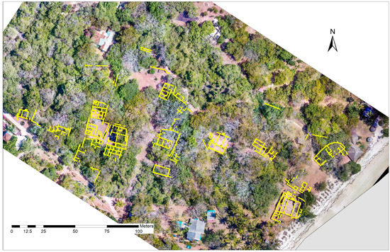
Figure 2.
The aerial view of Jumba la Mtwana showing the location of buildings and isolated standing walls in yellow.
The monumentality of the ruins of the town attracted the attention of archaeologists relatively early in the post-WWII period [17]. The most extensive excavation on the site conducted to date took place in the 1970s [16] and targeted the mosques and some of the large houses [16]. The site was last surveyed and planned in the 1980s [5]. It was therefore after several decades that the site was again studied by the author and the ‘Zamani’ geomatics team (University of Cape Town) in 2021, when the total extent of the preserved buildings and features was recorded with a 3D scanner, using Z+F imager 5010X [34].
The survey aimed to gain the most detailed data on the stone-built environment of the town to date, which would primarily allow a quantification of the variety of features associated with the element of water and provide a basis for assessing their spatial distribution, management and use. To fully assess this aspect of precolonial urban life, the second goal of the survey was to obtain 3D scans of the variety of features associated with freshwater, and to compare their size and design, deriving local regularities and preferences in their construction. Thirdly, the aim was to analyse the placement patterns of these features, consider the relative proportion of their association with private and public spaces, and interpret their potential role in the sensory environment.
3. Results
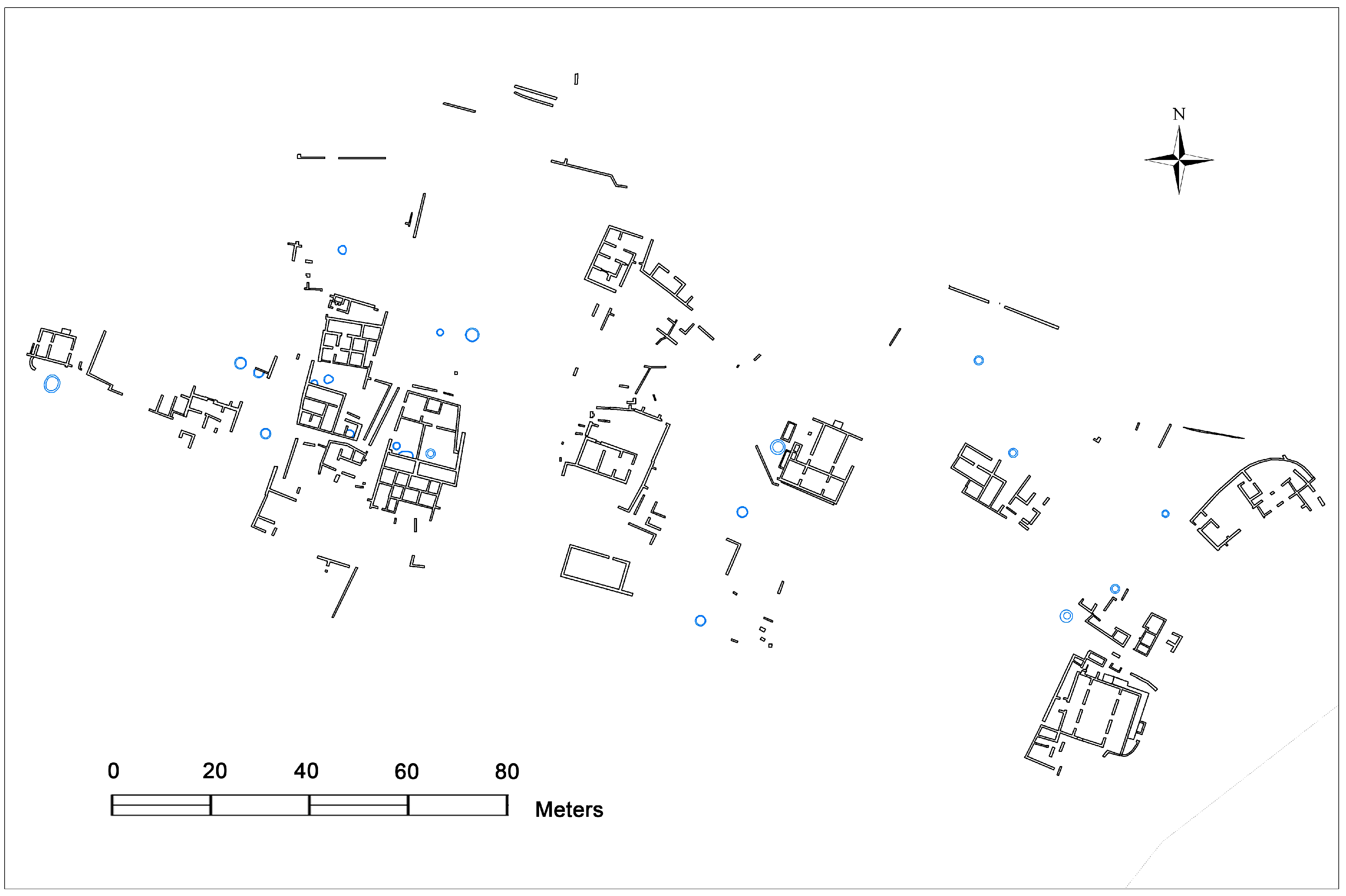
During the survey, it was noted that the town of Jumba la Mtwana featured an unusually high number of wells—their distribution among the recorded architectural structures is shown on Figure 3. Apart from wells, there were features intended for the storage of freshwater, such as cisterns and ablution pools. There was also evidence of the preserved bottom of a large jar, set in the ground for the storage of water.
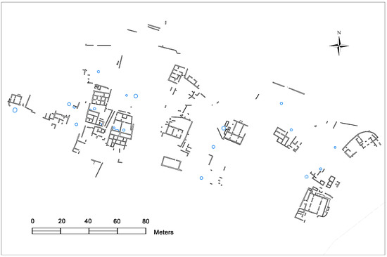
Figure 3.
The layout plan of Jumba la Mtwana showing the location of wells and cisterns in blue.
3.1. Types of Features
3.1.1. Wells
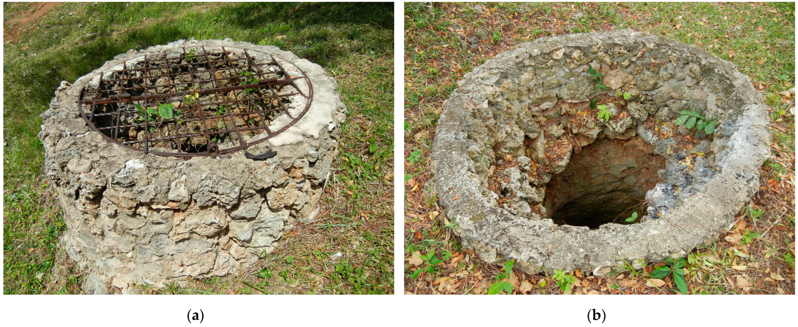
The wells at Jumba la Mtwana (Figure 4) were built in relatively regular circular shapes and their opening is on average raised around 50 cm above the current ground level. The thickness of the well walls, measured at the rim, is approximately 30 cm +/− 5 cm. Interestingly, in comparison with houses or mosques, the outer façade of the side walls was kept rough and without plastering, at least in some cases. This is evident from the fact that on the better-preserved wells, no evidence of remaining plaster pieces was identified. Hence, the wells were likely to be darker in color, in contrast with other structures, where regular re-plastering maintained their bright white outlook. To estimate the original depth of the wells was not possible, as they have been filled in to varying degrees, but some of them still reach a depth of several meters. Wells have been argued to represent one of the earliest stone features in other precolonial towns in Kenya, such as Shanga or Gede [3,35], and the fact that most buildings on the site of Jumba la Mtwana featured a well in the courtyard or at a distance of several meters from each house suggests that since the foundation of the town, buildings were planned here along with the location of the wells.
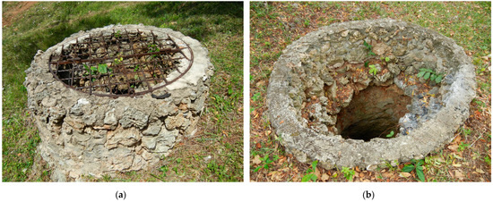
Figure 4.
Examples of some types of wells in the precolonial town of Jumba la Mtwana, Kenya. Photos by the author, 2021. (a) A well near the center of the town. (b) An example of a well found by the houses.
3.1.2. Cisterns and Water Containers
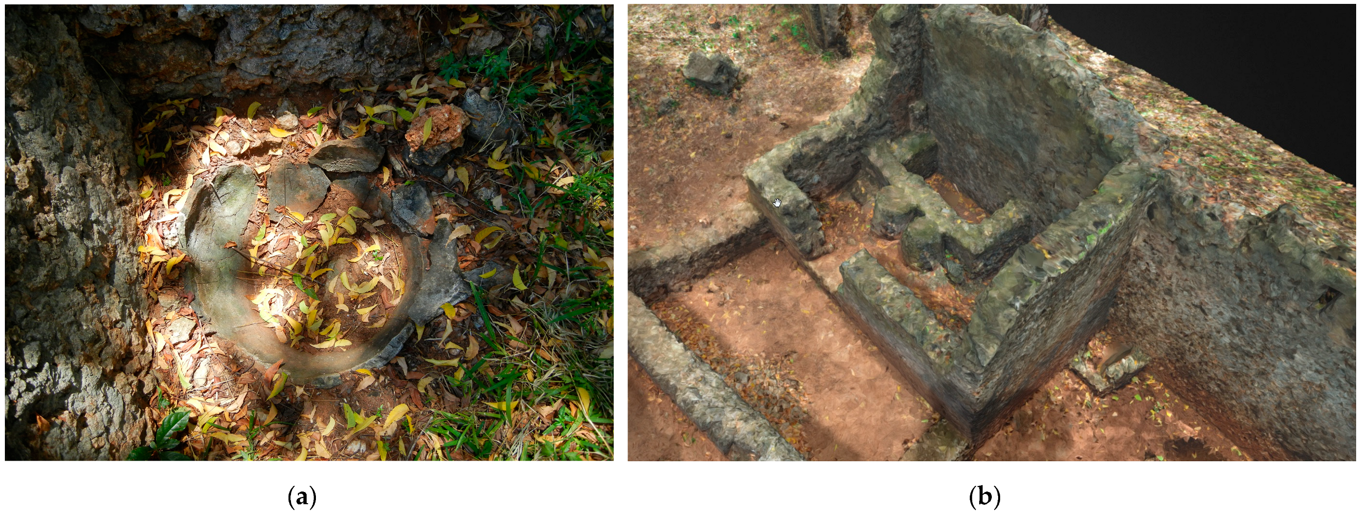
Some cisterns for freshwater were identified at Jumba la Mtwana, but there were only three of them, all located within the houses abutting one of their interior walls. In two cases, these were oblong features with rounded corners located on courtyards, and in one case, a regular oblong feature associated with two cylindrical seats (Figure 5). This unique feature in a room, which was probably used as a washing room/bathroom, gave the ‘House of the Cylinders’ its name [5]. As another type of water container, some open-air courtyards of the houses featured large water jars inset in the ground for the storage of freshwater, clear evidence of which is also preserved on the site of Jumba la Mtwana (Figure 5).
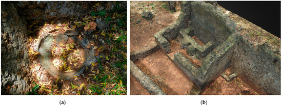
Figure 5.
Examples of water containers from the precolonial town of Jumba la Mtwana. (a) A depression with the remainder of an inset water jar in the court of the largest house in the town, known as ‘House of Many Doors’, photo by the author, 2021; (b) A cistern in the so-called ‘House of the Cylinders’, which received its name after the two cylindrical seats, 3D scan processed by the Zamani 2021.
3.1.3. Ablution Pools
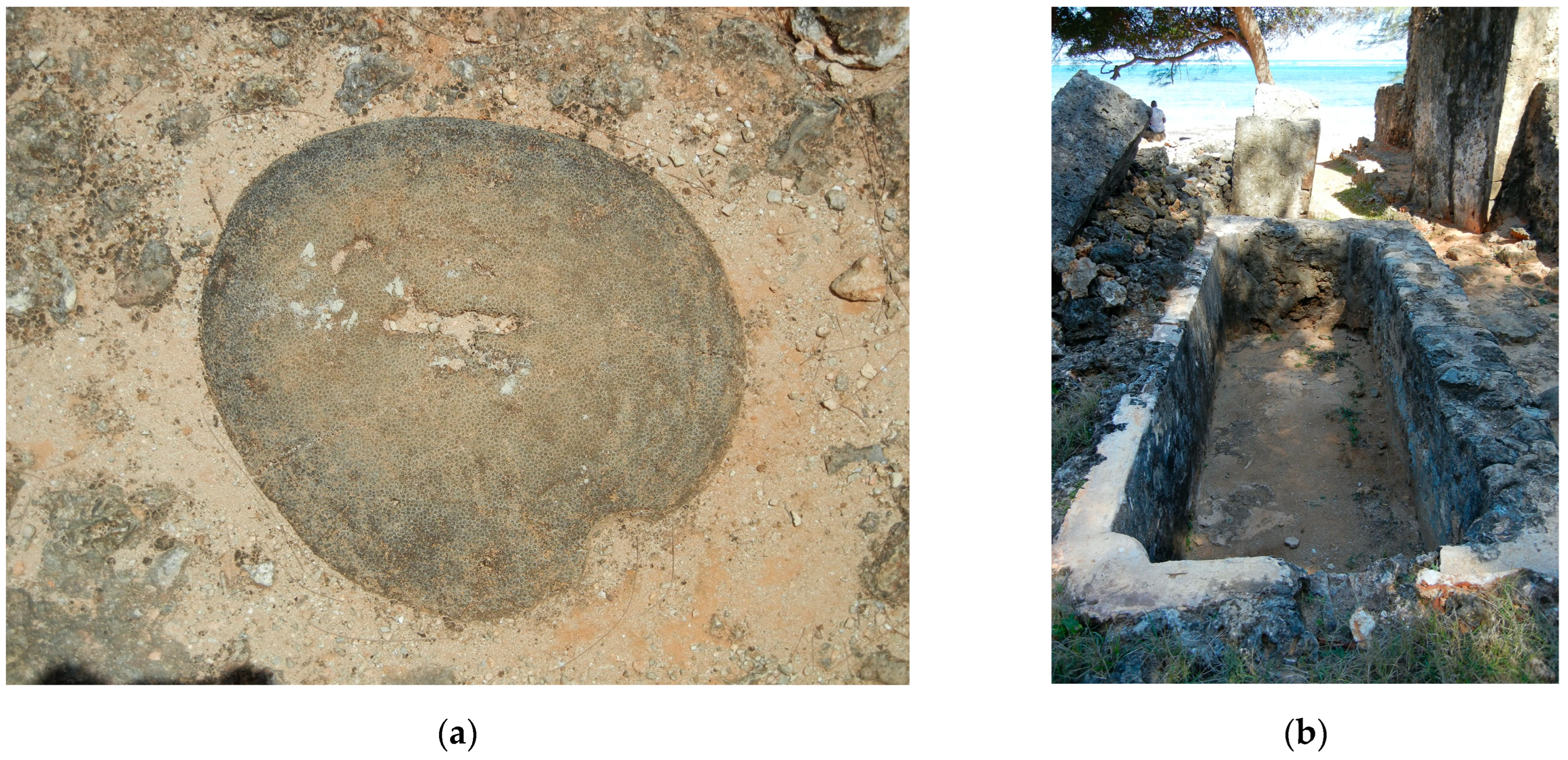
Similar to other Islamic Swahili towns, there were ablution pools in the context of mosques, especially in the larger ones. At Jumba la Mtwana the largest mosque is located directly on the beach and features the largest pool on the site. As ablution was an important practice conducted before prayer in the mosques, the pools were part of the customs associated with purity. In the direct spatial context of the ablution pool, footscrapers were recorded, which were used for the scrubbing of feet (Figure 6). There were also short conduits for channeling water between wells and ablution pools.
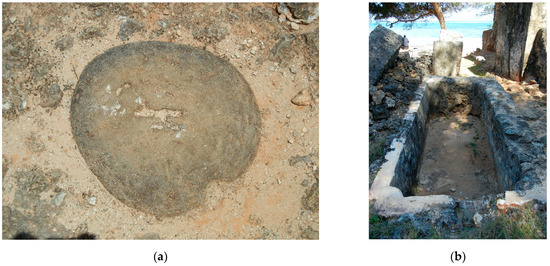
Figure 6.
Footscrapers and ablution pools were located by the mosques and used for cleansing practices. They were of coral rag–the same material used for construction on the Swahili coast. (a) Footscraper from the Great Mosque by the Sea at Jumba la Mtwana, situated close to the ablution pool; (b) an ablution pool by the largest mosque on site, known as Great Mosque by the Sea, which was fed by a short conduit.
3.2. Density and Spatial Context of Features Associated with Water
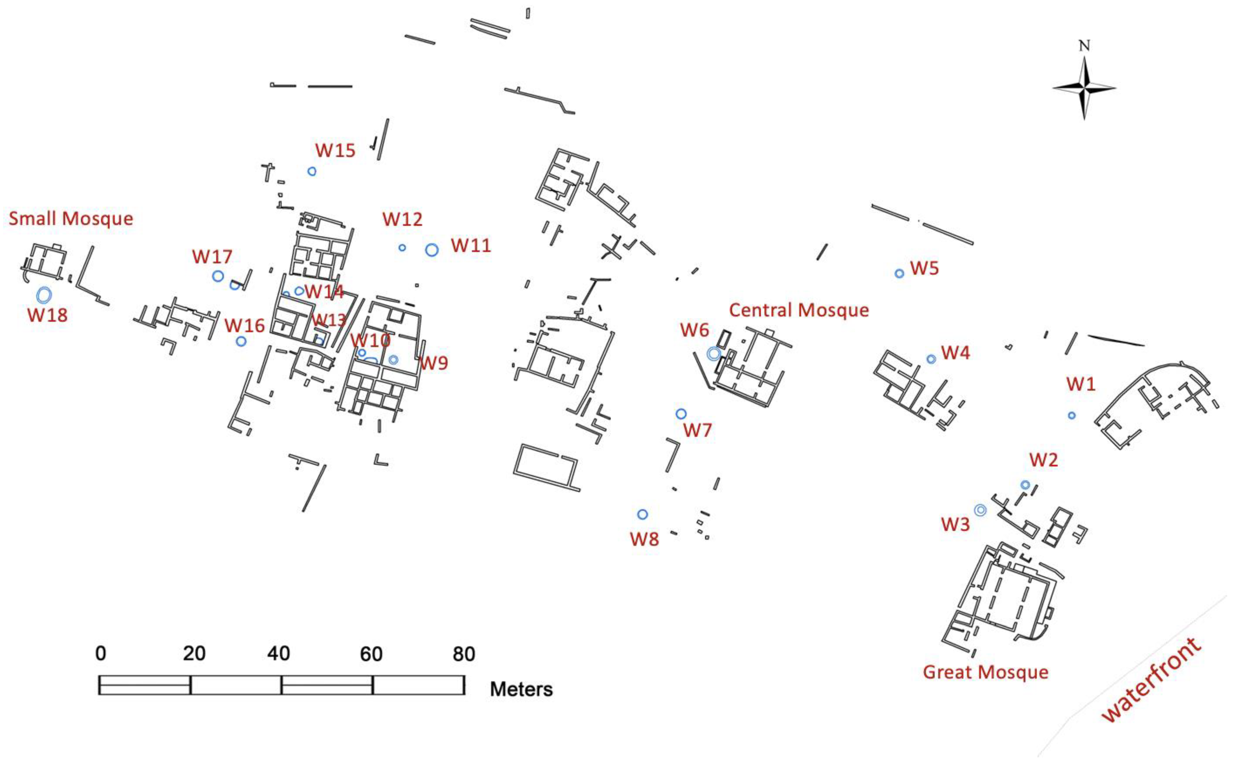
At Jumba, 18 wells were identified on an area of about 3 ha (Figure 7). This may be contrasted with other precolonial towns, whose occupation overlapped with Jumba la Mtwana. At Gede, a well-studied Swahili site in northern Kenya, there were 13 wells on 7 ha, and this was argued to represent a relatively high number [7] (pp. 252–253). At Songo Mnara, an island town in Tanzania, only 4 wells were identified, with water resources complemented by freshwater collected in cisterns and stored in a number of water jars [7] (p. 254). The number of wells in precolonial towns may be to some extent affected by the number of mosques, which are nearly always associated with a well, intended for the ritual cleansing by the ablution pool. However, with the average of 6 wells/ha, the density of wells at Jumba la Mtwana is extremely high, and out of proportion in comparison with other precolonial towns. It may actually be a sign of availability and the relatively good quality of freshwater drawn from the wells. Considering the presence of few cisterns for collecting rainwater, it may mean that not many such containers were needed to supplement the water from wells.
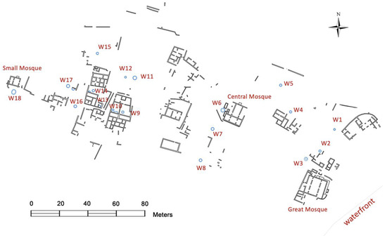
Figure 7.
The layout plan of Jumba la Mtwana showing the numbered location of the wells. The figure also highlights that no wells were identified in the central part of the preserved town.
The character and spatial context of individual wells are listed in Table 1, with their location shown on Figure 7. In terms of size, the smallest recorded well has a diameter of 1.4, while the largest is 3.4 m. As for their distribution, the smallest recorded distance between two wells is 6.5 m between W11 and W12 located in an exterior space, which may also be compared with the distance of 7 m between W9 and W10 located in courtyards. In association with each of the three mosques, a well was identified. In sum, there were five wells on courtyards of houses and approximately ten wells in exterior spaces, with some uncertainty about the spatial context in case of two wells due to the poor preservation of the nearby walls. For comparison, at Gede, most wells were associated with mosques or located on exterior/open spaces, and only in two places were they confirmed in the courtyards of a grand house [3,36].

Table 1.
The table shows the diameter and placement of all wells identified in the town of Jumba la Mtwana.
The central area of the present-day site of Jumba la Mtwana is curiously without wells (Figure 7). In this area, approximately four houses might have been located, some of them relatively large and with beautifully elaborated doorways. It is possible there were wells in the past which have been filled up, and that their openings have disappeared. Alternatively, the nearest wells to these houses were W11 and W12 located in an open space. Conversely, in the southern portion of the site with W7 and W8 and with relatively poor preservation of architectural remains, the location of two additional houses that have not been preserved may be presumed on the basis of the presence of the wells and isolated remains of walls.
Overall, several regularities may be concluded analysing the character and distribution of wells across the preserved built environment of Jumba la Mtwana:
- The average diameter of a well at Jumba la Mtwana is 2.1 m, while the median diameter is 1.9 m;
- Wells were located in the exterior space of the town or in courtyards and by the outer walls of mosques;
- There was no apparent preference for placing larger wells more centrally in terms of the town layout;
- The three largest wells were identified in the context of the mosques;
- The size of a well was not proportionate to the importance and size of mosques, as the smallest well in a mosque context was identified by the so-called Great Mosque by the Sea. In this vein, more important might have been the size of the ablution pool, which better corresponds with the size of the mosque.
4. Discussion
The results of the architectural survey and analysis at Jumba la Mtwana suggest that the element of water played an important role in the built environment of the precolonial town. Comparing these results with studies conducted on other precolonial towns, where in a few cases the architecture has been studied with up-to-date technologies and methodologies, some broader implications for the East African coast may be derived.
4.1. Precolonial Water Management
The precolonial water management on the East African coast hinged on the balance between access to freshwater and positioning the towns directly on the oceanfront, which facilitated access to marine resources and to trade networks. Access to freshwater was provided by digging wells and storing rainwater in various containers. Ethnographically, it has been argued that in a number of towns, water in wells located nearer to the oceanfront is often fresher than from those further away, although this may be contrary to expectations [37]. In Jumba la Mtwana, the wells were spread more or less evenly across the town, and although among the buildings on the beach the wells are located approximately 6 m lower compared to the rest of the site, the density of wells overall does not suggest a preference for any part of the site.
The close proximity of wells to one another could not have been regarded as a problem, as they were in several cases found within 10 m distance from one another. Either they were not used simultaneously, as tapping into another freshwater source was possible by digging a well nearby, or pairs of wells in close proximity both had the capacity to provide water. Considering the current situation on the coast in the Mombasa area, the availability of groundwater or its different chemical composition may change with the turn of seasons [38], and it is possible that there was seasonality involved in the use of individual wells in the past too.
Considering, also, that the number of wells was extremely high in Jumba la Mtwana, with only few cisterns or containers of any kind identified, it may be concluded that the wells provided enough water for the town, and the storage of rainwater did not represent a significant proportion of freshwater resources. It is also possible that water from wells was used for other communal purposes, e.g., for agriculture, although this cannot yet be ascertained. It may be stated that every household had access to a private well, or direct access to a nearby well located in the exterior space of the town, which resulted in a rather rare situation for a Swahili precolonial town.
4.2. Social Context
The quantity of wells was likely to have catered for a busy social environment. As known from the historical sources regarding Bagamoyo, Tanzania, people met by the wells to socialise at least for the last few centuries [22]. With up to 10 wells located in publicly accessible exterior spaces in Jumba la Mtwana, which might have served at least the houses in their vicinity, the opportunity for social encounter was also significant in this precolonial town. In the central area of the site, especially around wells W11 and W12 (Figure 7), the area might have served as a meeting space for the houses surrounding it. This part of the site was also directly accessible through the low town wall that surrounded the town just 60 m to the north, and might have represented an open public space inside the wall.
4.3. Sensory Aspect of the Architectural Environment
Sensory access to water was ever-present in the town of Jumba la Mtwana. From virtually anywhere on the site visual access to a well in the vicinity was possible. In addition, the size of pools and cisterns might have been visually important, as their presence and size are associated with the most monumental structures. The distribution of stone buildings shows that auditory access to the ocean was possible even from the most distant Small Mosque [33]. Most cisterns in the town were likely to be intended for ablution in the context of mosques or private washing in the houses, which signifies an association with cleanliness and haptic experience with water. The haptic experience was strengthened by linking cistern and ablution pools with features such as footscrapers. Building features for drawing and containing water hence significantly affected the perception of the built environment in the precolonial town.
4.4. Implications for Later Urban Development
More research on a larger quantity of precolonial Swahili towns is needed to ascertain how the individual towns differed in managing access to water as a resource and as part of urban life. In the light of the archaeological research of the last two decades at least, it appears ever less likely that the precolonial towns were abandoned because of increased salinity of wells or lack of water, as originally frequently proposed by early research, as a mix of wells and cisterns that was unique to each town was likely to represent a conscious choice and long-term sustainable solution. On many sites, including Jumba la Mtwana, these findings may also be incorporated to cultural heritage conservation agenda and in the presentations of the precolonial Swahili towns to the public, raising awareness of the long history of the roles and management of urban water.
Compared with later colonial towns such as Mombasa, Kenya or Bagamoyo, Tanzania, the distribution of freshwater sources was fairly even across towns in the precolonial period. With later development, present-day towns become increasingly densely populated, exceeding the capacity of the coastal environment [21]. Although past practices of water management in a given area are out of proportion to present-day needs, they may provide hints about possible strategies that functioned in the past, and potentially inform better solutions for current urban development. It may be concluded that the role of the element of water in the precolonial built environment had a spatial as well as a social component, which may be contrasted with later development that has increasingly downplayed the long-term management as well as the social role of water resources.
Funding
This research and the APC was funded by the CZECH SCIENCE FOUNDATION (Grant Agency of the Czech Republic), grant “Comparing urban morphological transformation in precolonial to colonial urban traditions”, number 20-02725Y, awarded to the author.
Data Availability Statement
All data from 3D scanning have been presented to the National Museums of Kenya. Restrictions apply to the availability of these data, which cannot be used without the permission of the NMK, the Zamani survey team and the author. Data required for research purposes are available from the author, subject to permission of the NMK and Zamani.
Acknowledgments
The field survey of Jumba la Mtwana and the technical aspects of raw data processing were realised in collaboration the Zamani, a survey team from the Department of Geomatics, University of Cape Town, working under the permit of the National Museums of Kenya.
Conflicts of Interest
The author declares no conflict of interest. The funders had no role in the design of the study; in the collection, analyses, or interpretation of data; in the writing of the manuscript; or in the decision to publish the results.
References
- Ondigo, D.A.; Kavoo, A.M.; Kebwaro, J. Water Resources and Management under Increasing Urban Demography: A Kenyan Perspective—A Review. J. Water Resour. Prot. 2018, 10, 919–938. [Google Scholar] [CrossRef]
- Bissell, W.C. Urban Design, Chaos, and Colonial Power in Zanzibar; Indiana University Press: Bloomington, IN, USA, 2011. [Google Scholar]
- Kirkman, J.S. The Arab City of Gedi; Excavations at the Great Mosque, Architecture and Finds; Oxford University Press: London, UK, 1954. [Google Scholar]
- Kirkman, J.S. Men and Monuments on the East African Coast; Lutterworth: London, UK, 1964. [Google Scholar]
- Sassoon, H. The Coastal Town of Jumba la Mtwana. Kenya Past Present 1980, 12, 2–14. [Google Scholar]
- Kirkman, J.S. Gedi—A Late Mediaeval city of the Swahili Sub-Arab culture of the East African coast. Proc. Semin. Arab. Stud. 1974, 4, 97–104. [Google Scholar]
- Wynne-Jones, S.; Fleisher, J. Water Management in a Maritime Culture: The Swahili Coast of East Africa. In A History of Water; Tvedt, T., Oestigaard, T., Eds.; IB Tauris: London, UK, 2014; pp. 240–258. [Google Scholar]
- Sulas, F.; Fleisher, J.; Wynne-Jones, S. Geoarchaeology of urban space in tropical island environments: Songo Mnara, Tanzania. J. Archaeol. Sci. 2017, 77, 52–63. [Google Scholar] [CrossRef]
- Sinclair, P.; Nordquist, G.; Herschend, F.; Isendahl, C. The Urban Mind. Cultural and Environmental Dynamics; Uppsala University: Uppsala, Sverige, 2010. [Google Scholar]
- Sulas, F.; Madella, M. Archaeology at the micro-scale: Micromorphology and phytoliths at a Swahili stonetown. Archaeol. Anthropol. Sci. 2012, 4, 145–159. [Google Scholar] [CrossRef]
- Breen, C.; Lane, P. Archaeological approaches to East Africa’s changing seascapes. World Archaeol. 2003, 35, 469–489. [Google Scholar] [CrossRef]
- Donley-Reid, L. A structuring structure: The Swahili house. In Domestic Architecture and the Use of Space; Kent, S., Ed.; Cambridge University Press: Cambridge, UK, 1990; pp. 114–126. [Google Scholar]
- Lefebvre, H. The Production of Space; Blackwell: Oxford, UK, 1991. [Google Scholar]
- Haug, A.; Muller, U. Introduction. In The Power of Urban Water: Studies in Premodern Urbanism; Chiarenza, N., Haug, A., Muller, U., Eds.; De Gruyter: Berlin, Germany, 2020; pp. 1–12. [Google Scholar]
- Van Oers, R.; Roders, A.P. Historic cities as model of sustainability. J. Cult. Herit. Manag. Sustain. Dev. 2012, 2, 4–14. [Google Scholar] [CrossRef]
- Kirkman, J.S. Notes on Jumba la Mtwana; National Museums of Kenya: Nairobi, Kenya, 1974. [Google Scholar]
- Garlake, P.S. The Early Islamic Architecture of the East African Coast; Published for the Institute by the Oxford University Press: Nairobi, Kenya, 1966. [Google Scholar]
- Wilson, T.H. The Monumental Architecture and Archaeology of the Central and Southern Kenya Coast; National Museums of Kenya: Nairobi, Kenya, 1980. [Google Scholar]
- Verschuren, D.; Laird, K.R.; Cumming, B.F. Rainfall and drought in equatorial east Africa during the past 1100 years. Nature 2000, 403, 410–414. [Google Scholar] [CrossRef] [PubMed]
- WRMA. Integrated Water Resources Management and Water Efficiency Plan for Kenya; WRMA: Nairobi, Kenya, 2009. [Google Scholar]
- Kithiia, J.; Gamoyo, M. Motion but no speed: Colonial to post-colonial status of water and sanitation service provision in Mombasa city. Cities 2020, 107, 102867. [Google Scholar] [CrossRef]
- Fabian, S. Making Identity on the Swahili Coast: Urban Life, Community, and Belonging in Bagamoyo; Cambridge University Press: New York, NY, USA, 2019. [Google Scholar]
- Kamalkhan, K. The Swahili Architecture of Lamu, Kenya: Oral Tradition and Space; LAP Lambert: London, UK, 2010. [Google Scholar]
- Meier, P. Swahili Port Cities: The Architecture of Elsewhere; Indiana University Press: Bloomington, Indianapolis, 2016. [Google Scholar]
- Barth, F.G.; Giampieri-Deutsch, P.; Klein, H.-D. Sensory Perception: Mind and Matter; Springer: Wien, Austria, 2012; p. 404. [Google Scholar]
- Day, J. Making Senses of the Past: Toward a Sensory Archaeology; Southern Illinois University Press: Carbondale, IL, USA, 2013. [Google Scholar]
- O’Meara, S. Haptic vision: Making surface sense of Islamic material culture. In The Routledge Handbook of Sensory Archaeology; Skeates, R., Day, J., Eds.; Routledge: London, UK, 2019; pp. 467–480. [Google Scholar]
- Donley, L. House power: Swahili space and symbolic markers. In Symbolic and Structural Archaeology; Hodder, I., Ed.; Cambridge University Press: Cambridge, UK, 1982; pp. 63–73. [Google Scholar]
- Donley-Reid, L. Life in the Swahili town house reveals the symbolic meaning of spaces and artefact assemblages. Afr. Archaeol. Rev. 1987, 5, 181–192. [Google Scholar] [CrossRef]
- Baumanova, M. Pillar Tombs and the City: Creating a Sense of Shared Identity in Swahili Urban Space. Archaeologies 2018, 14, 377–411. [Google Scholar] [CrossRef]
- Wynne-Jones, S. A Material Culture: Consumption and Materiality on the Coast of Precolonial East Africa; Oxford University Press: Oxford, UK, 2016. [Google Scholar]
- Petek-Sargeant, N.; Lane, P.J. Weather Landscapes and Archaeology: Material weathering practices and tangible climates. Archaeol. Soc. Environ. 2022, 2, 1–24. [Google Scholar] [CrossRef]
- Baumanova, M. Precolonial soundscapes of Swahili coastal towns in East Africa. Time Mind: J. Archaeol. Conscious. Cult. 2021, 14, 501–516. [Google Scholar] [CrossRef]
- Baumanova, M. Survey and analysis of the architectural heritage at Jumba la Mtwana and Mnarani, precolonial Swahili towns in Kenya. Ann. Naprstek Mus. Prague 2022, 43, 107–124. [Google Scholar] [CrossRef]
- Horton, M. Shanga: The Archaeology of a Muslim Trading Community on the Coast of East Africa; British Institute in Eastern Africa: London, UK, 1996. [Google Scholar]
- Pradines, S. Gedi: Une Cité Portuaire Swahilie: Islam Médiéval en Afrique Orientale; Institute Francais d’Archéologie Orientale: Cairo, Egypt, 2010. [Google Scholar]
- de Vere Allen, J. Swahili Culture and the Nature of East Coast Settlement. Int. J. Afr. Hist. Stud. 1981, 14, 306–334. [Google Scholar] [CrossRef]
- Idowu, T.E.; Nyadawa, M.; k’Orowe, M.O. Hydrogeochemical assessment of a coastal aquifer using statistical and geospatial techniques: Case study of Mombasa North Coast, Kenya. Environ. Earth Sci. 2017, 76, 422. [Google Scholar] [CrossRef]
Disclaimer/Publisher’s Note: The statements, opinions and data contained in all publications are solely those of the individual author(s) and contributor(s) and not of MDPI and/or the editor(s). MDPI and/or the editor(s) disclaim responsibility for any injury to people or property resulting from any ideas, methods, instructions or products referred to in the content. |
© 2023 by the author. Licensee MDPI, Basel, Switzerland. This article is an open access article distributed under the terms and conditions of the Creative Commons Attribution (CC BY) license (https://creativecommons.org/licenses/by/4.0/).

