1. Introduction
Anthropogenic land uses contribute significantly to global environmental change [
1,
2,
3,
4]. Over the past few decades, land uses have contributed to the increasing forest cover degradation, a phenomenon that is likely to contribute more to climate change in the next years ahead [
5,
6]. Governmental and non-governmental organizations are contributing to combating forest degradation [
7,
8,
9,
10]. However, there is still some more work to be done to reduce the rate of forest degradation, especially in tropical regions where the exploitation of forest resources is a greater part of people’s livelihoods [
11,
12,
13]. Nonetheless, the degradation of the forests in the quest to satisfy livelihood needs would likely adversely impact livelihoods in the future.
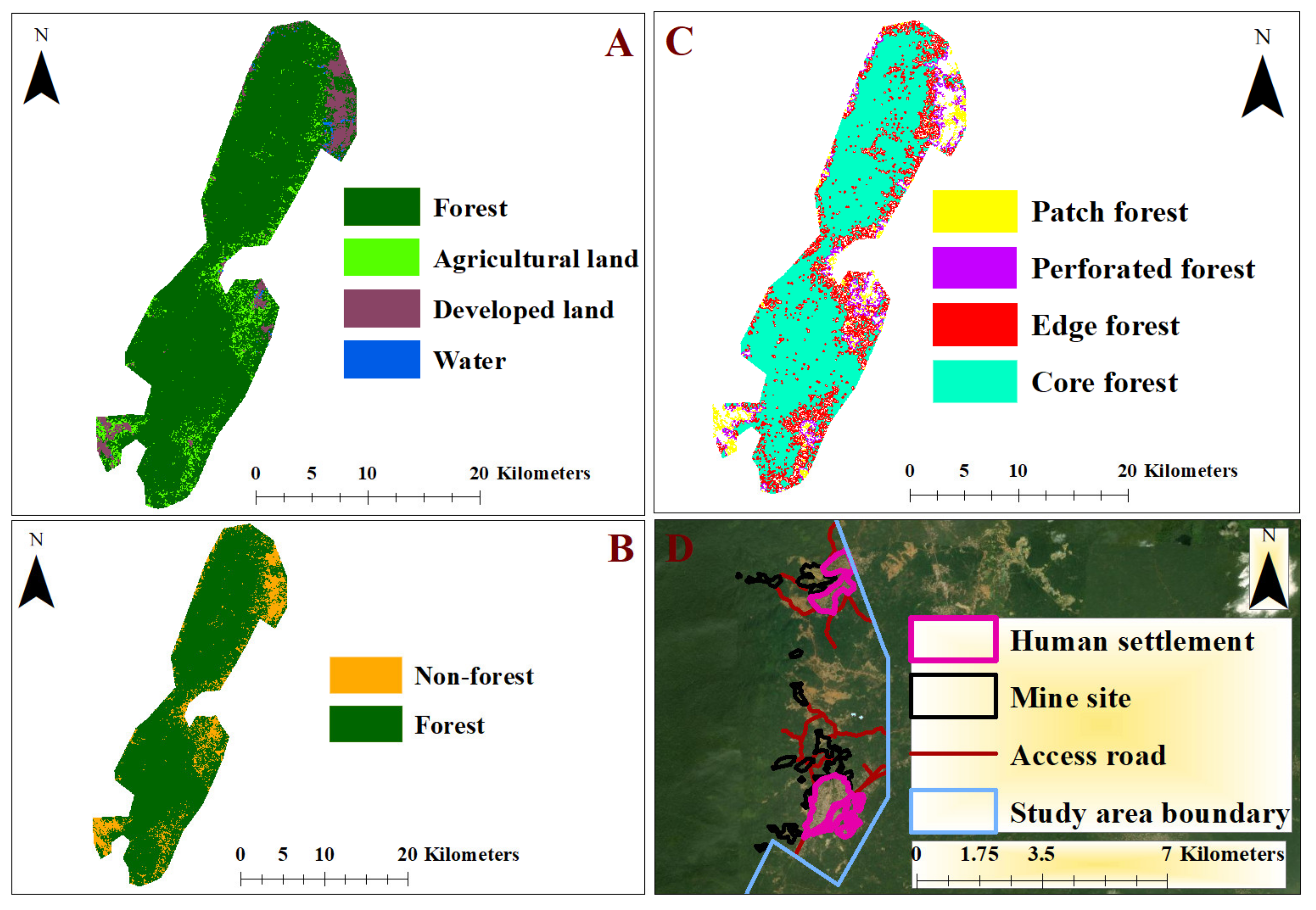
Core forest, an area of forest occurring outside the edge effect area and is not degraded by fragmentation [
14,
15], would likely perform socio-ecological functions (Note: the edge effect area is a distance of 100 m from non-forest to the forest interior where human activities, wildfires, micro-climate effects, and the effects of fragmentation would likely degrade forest cover [
16,
17]). Maintaining intact and large contiguous core forest patches would be necessary for preserving the integrity of forest ecosystems, providing non-timber forest products for communities, and reducing the impacts of global climate change through carbon sequestration [
18,
19]. Thus, the protection of a larger part of the core forest from land uses would be necessary, and to do so, there is a need to study the association between a variety of land uses and core forest patches. This would improve land managers’ understanding of the various land uses that would likely contribute to the degradation of core forest patches and consequently develop policies and management measures for the protection of the core forests. Moreover, this would ensure that policies and management initiatives that protect the forests are created in such a way that both ecological integrity and sustainable land use are ensured.
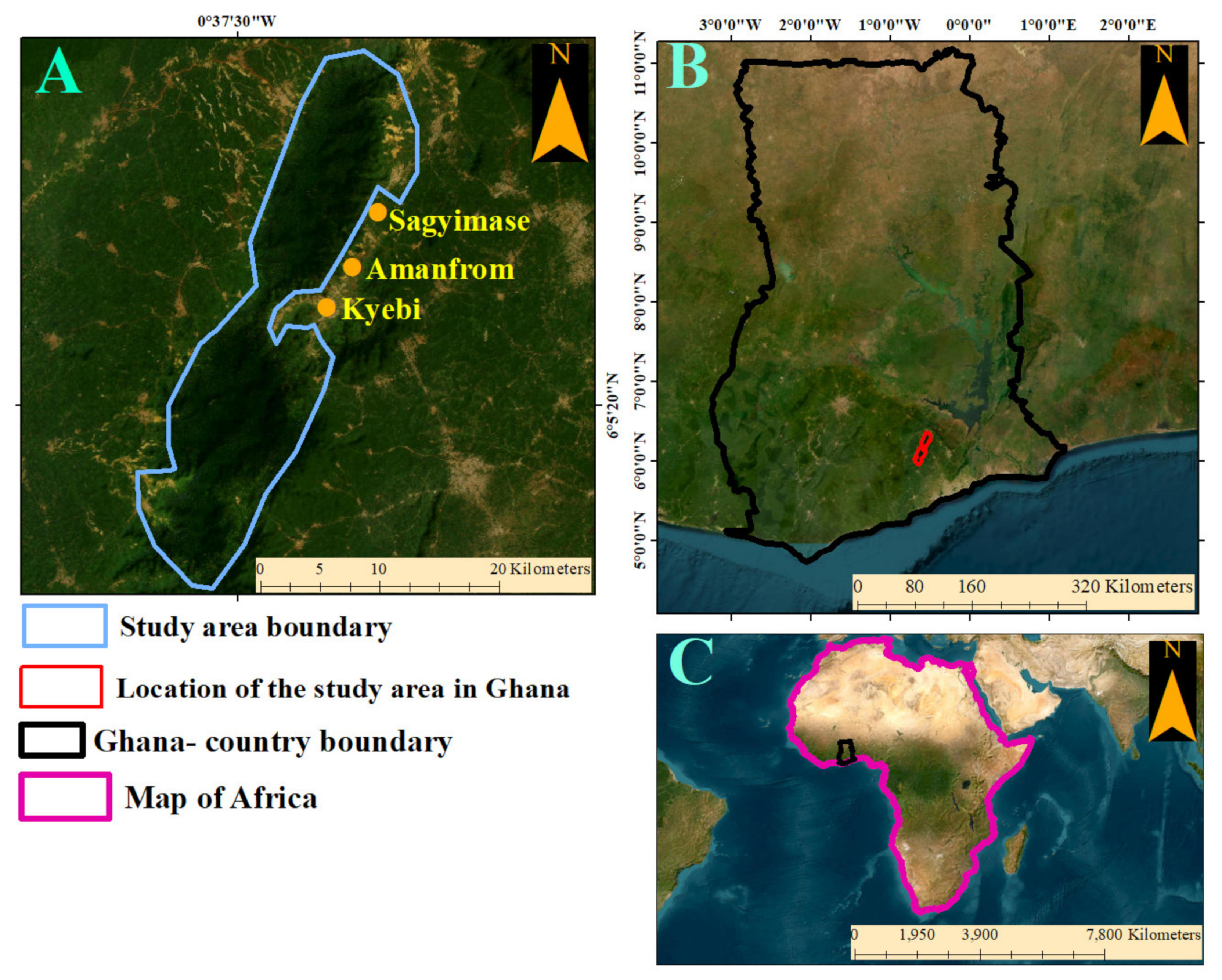
Our study area is the Atewa Range Forest Reserve (ARFR). Focusing our study on the ARFR, an area that falls within the tropical forest region, offers room to compare our study findings with findings from other tropical forest regions of the world. Similar to other tropical forest environments where land uses are increasing, the ARFR is experiencing a recent increase in the rate at which forest cover is being cleared for various land uses [
20,
21,
22]. The situation of forest degradation in the forest would likely increase with the proposition of the site for large-scale bauxite mining [
23]. For instance, previous studies have noted that encroachment by farmers and recent mining exploration are on the rise and have contributed to disturbances in the forest ecosystem of the reserve [
22,
24,
25]. The various land uses and forest cover patches would likely be influenced by terrain characteristics (e.g., slope and elevation). For instance, intact forest cover patches would likely be found on higher elevations due to a lack of access by humans. The ARFR as a protected landscape and a globally significant biodiversity area (GSBA) is expected to have a minimal amount of human influence, and the landscape is given the best possible protection while ensuring that non-threatening anthropogenic activities (e.g., harvesting non-timber forest products) are undertaken sustainably.
Previous land use and land cover studies in tropical forest regions (e.g., Asia, Africa, and Latin America) have focused mostly on measuring and predicting direct land cover change and fragmentation [
21,
26,
27,
28,
29]. However, similar to predicting direct land cover change, Oduro Appiah and Agyemang-Duah [
30] used geospatial approaches and statistical modeling to measure the relationship between land uses and forest patch sizes in the Tano-Offin Forest Reserve in Ghana. In the ARFR, Kusimi [
22] used GIS and remote sensing approaches to measure land use and cover change, noting how land use impacts forest cover. These studies in the tropical regions contribute to understanding the dynamics of land uses and most importantly, emphasize the relevance of applying geospatial approaches in measuring landscape characteristics. However, measuring the relationship between core forest patches, land uses, and other associated factors was beyond the scope of the previous studies. Thus, this study builds on previous studies by filling this knowledge gap.
Based on the knowledge gap identified, the objective of this study is to propose a model that expresses the relationship between core forest patches (dependent variable), land uses, and terrain characteristics (independent variables). The study uses GIS and remote sensing techniques (random forest machine learning classification) and methods from landscape ecology to process satellite images and construct the patches of forest cover and other land uses. With the aid of a logistic regression model, we propose a model that shows the association between core forest patches, land uses, and terrain characteristics (e.g., slope and aspect). Our study is relevant because it provides a spatial model for landscape managers and policymakers to develop land management strategies needed for protecting core forest patches from being impacted by the footprints of anthropogenic activities. Most importantly, with the outcome of this study, land managers can develop measures to ensure that anthropogenic activities are undertaken sustainably.
4. Discussion
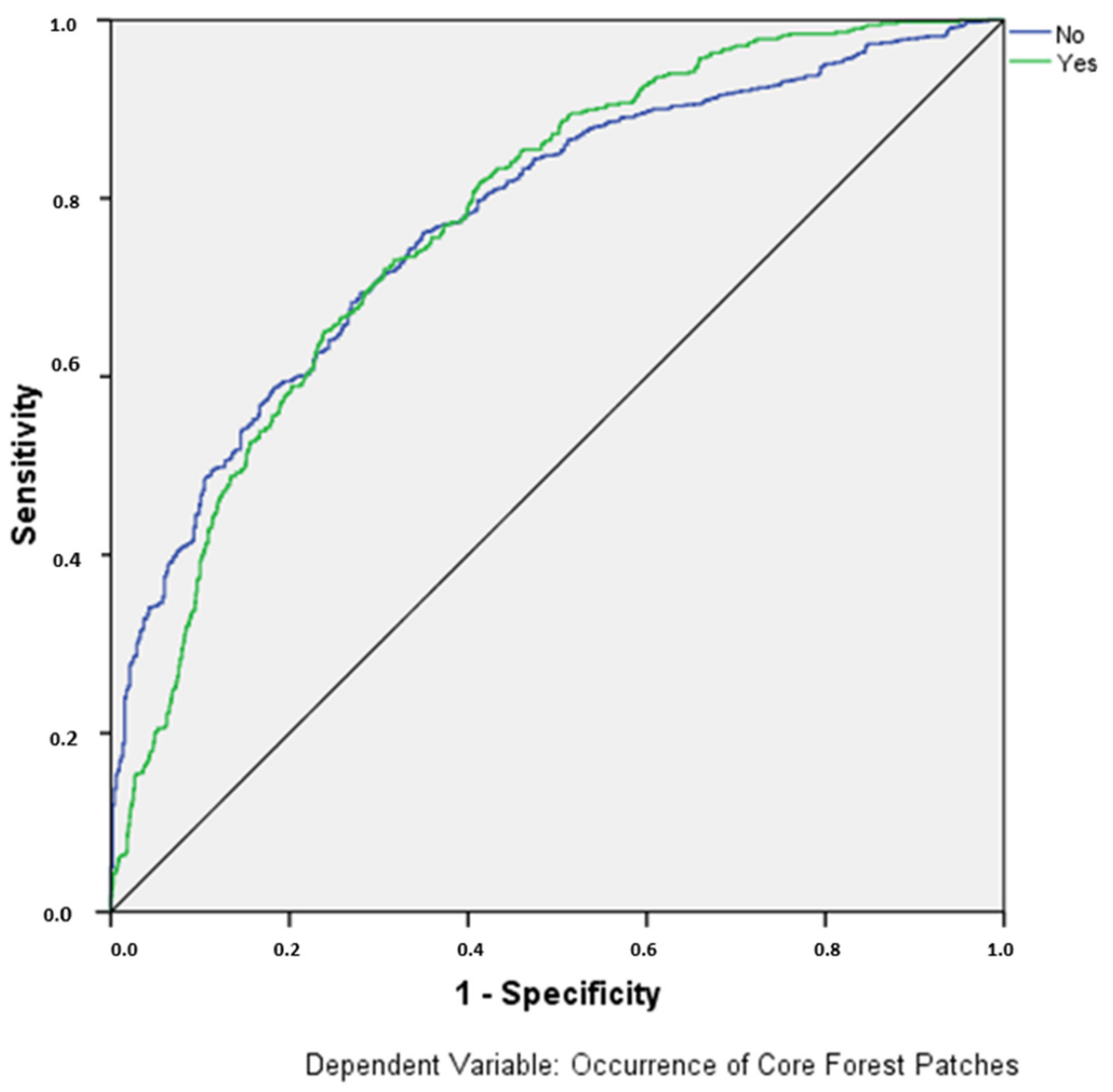
We present a model showing the relationship between the occurrence of core forest patches and land use and terrain variables. A significant association between the occurrence of core forest patches and elevation, slope, aspect, logging sites, mine sites, and access roads has been identified through the modeling process. With this association being established, the ROC value of 0.775 achieved in this analysis suggests that a modest, acceptable, and robust model has been produced. Similar ROC values (e.g., 0.715 and 0.790) have been reported in a previous study that used terrain and distance-land use variables in analyzing forest cover conversion patterns [
45,
46]. Furthermore, from our analysis, the outcome of the OTMC suggests that the final model results we have presented are a significant improvement upon the base model, the model without any explanatory variables.
Whereas our study compares results with that of previous studies from other tropical forest regions, studies that directly compare to ours are rare, and thus we make comparisons with studies that mostly focused on general land use and forest cover change. Our study outcome suggests that on higher elevations and higher slopes, intact forests are more likely to occur. This study outcome is likely due to the lack of easy accessibility at the higher slope and elevations by humans, and thus human activities would less likely take place on higher slopes and elevations. Also, the results of the study suggest that the high slopes and altitudes should likely be an area of focus in terms of crafting land management strategies and policies to protect the existing intact forest patches. With this being mentioned, this study outcome also creates an opportunity for the establishment of land policies that would likely improve sustainable land management in low-lying areas and low slopes on forest landscapes. Our results corroborate a related study in Chunati Wildlife Sanctuary, Bangladesh, in which Islam et al. [
42] noted that an increase in elevation and slope increases the probability that a vegetation patch will occur. However, Islam et al. [
46], did not indicate whether or not these vegetation patches are the core type. Concerning the direction of slope, Yang et al. [
47] have shown that north- and south-facing slopes influence differences in vegetation structure (biomass, cover, and height) in southwest China. In other tropical regions of the world (e.g., Indonesia and India), such terrain variables play roles in the occurrence of vegetation patches [
48,
49]. Thus, this demonstrates that terrain variables influence the nature of vegetation cover in other locations similar to what we have found in our study. However, the differences, for instance, in how the direction of slope variable influences vegetation structure may also be determined by latitudinal differences and the amount of solar radiation received in the various environments [
50,
51]. These differences present unique environmental challenges in different landscapes and thus these challenges would require unique land management strategies.
The study results note that logging in the forest reserve is significantly associated with the occurrence of core forests. Specifically, our results suggest that areas close to logging sites would likely not have more of the core forests as compared to areas far from the logging sites, and thus, intact forests would likely be located far from the logging sites. The outcome of our study is related to the results of a previous study in the Brazilian Amazon which found that logging activities give rise to non-contiguous forests in nearby areas culminating in the formation of many smaller fragments of forest cover [
52]. Similarly, in a related study that covers Africa, Asia, and Latin America, Putz et al. [
53] noted that the percentage of intact forests declines within logging blocks as the intensity of harvest increases. The rate at which non-core forests develop would increase at an increasing rate as more logging activities continue to penetrate core forest areas [
52]. Thus, with logging activities threatening most tropical forest regions, relevant land management measures would be necessary, especially in locations where logging activities have become a greater component of people’s livelihoods.
Similar to the logging activities, mining activities in the forest reserve have grown in recent times, and our study results show a significant association between mine sites and the occurrence of core forest patches. The study results suggest that core forests would more likely occur in areas far away from the mine sites. This outcome was expected because of the rate at which mining activities have increased in recent times in the forest reserve. Recent studies have noted that mining activities in tropical regions (e.g., India, Ghana, Colombia, Venezuela, Guyana, Suriname) contribute to a significant decline in forest cover [
22,
54,
55,
56,
57], and these are likely to affect the core forest patches. However, the use of sites in the forest landscape for mining would likely open up areas near the sites for other activities (e.g., the creation of mining infrastructure), and these are likely to result in further fragmentation and thus, the occurrence of fragmented forests near the mining sites. With our results, land managers could create land policies that would ensure core forest patches are protected by controlling the spatial spread of mine sites to many parts of the protected landscape. Thus, the results imply that land rehabilitation plans and policies should target the areas near the mine sites while increasing protection regimes in the areas farther away from these mine sites.
The results of our analysis suggest that the occurrence of core forest patches has a significant association with the presence of access roads in the forest reserve. Specifically, the study outcome suggests that core forest patches would likely be found in areas farther away from the access roads as compared to the areas closer to the roads. The areas close to the road would likely be accessed by humans, and thus, forests in those areas would likely be degraded because these areas would be opened to different levels of human influences. Hence, intact or core forest patches are less likely to be found close to the roads. Direct measurements of the impacts of access roads have shown that road construction has led to deforestation [
16]. As noted by Laurance et al. [
16], the degradation of forests contributed by roads in tropical forests is growing rapidly and is in two forms. First, through the clearance of forest for construction and second, through opening up of forest areas for humans to access hitherto inaccessible areas and thus, increasing the likelihood of clearing accessible forest areas for other human activities. Moreover, previous study results corroborate our results in that analysis from major tropical forest areas in Africa, Asia, and Latin America has found that intact forests are mostly found in areas far from access roads [
53]. In a related study, Teixeira et al. [
58] in an analysis of the Plateau of Ibiúna, southeast Brazil noted that forest regeneration significantly occurs in areas farther from roads. Thus, intact forests would likely form in these areas far from the road. The relationship between various land uses and the occurrence of core forest patches as indicated in the results calls for management measures and policies that protect forest patches that are farther away from land uses. Additionally, for managing the already fragmented forests, this study outcome shows that forest patches close to the land uses are mostly non-core forests and thus, management initiatives (e.g., tree planting) meant for regrowing and creating intact forest patches should target the areas close to land uses.
The results of our analysis show that forest patches are more likely to be core forests if they are found beyond 1 km from human settlement and agricultural land. However, the association between these human activity footprints and core forests is not statistically significant, implying the occurrence of core forest patches within or beyond 1 km from the two land uses is by random chance. Upon reviewing the spatial locations of human settlements, it was noticed that forests in general are not found in areas where human settlements are located, and it is likely that is the reason the association is not statistically significant. On the other hand, agricultural footprints are not associated with core forest patches likely because as found in a previous study [
59] agricultural lands are more likely to transition to forest cover in the future, and thus, the agricultural land locations would likely not be a problem and that would likely be the reason why they are not associated with whether or not core forest would occur. However, it is important to note that there will be a need to test more hypotheses to establish a robust conclusion about human settlements and agricultural land footprints and their association with core forest patches.
5. Conclusions
This study modeled the relationship between the occurrence of core forest patches and dominant anthropogenic activities and terrain variables. We show that core forest patches are significantly associated with land use and terrain variables. With a robust model, we conclude that core forest patches are found far away from land uses. Similarly, on higher slopes and elevations, core forest patches are more likely to occur relative to lower slopes and elevations. Moreover, our findings, based on the direction of slope, indicate that land managers have unique tasks of monitoring the different directions of slopes and ensuring that there is sustainable management of forest patches in protected landscapes. Thus, land management and land policies for maintaining core forests should target areas close to land uses as well as low slopes and elevations. Conversely, core forest preservation policies could target areas far away from land uses and areas on higher slopes and elevations.
With the current state-of-the-art geospatial satellite data processing having limitations, the classification of forest patches is less likely to be perfect given that there may be forest patch sizes that are less than the spatial resolution of the Landsat image used in this study. Thus, such a limitation would likely underestimate the number of patches and consequently the underestimation of the patches for the landscape morphological processing. Additionally, the selection of within 1 km and beyond 1 km distance threshold to classify the occurrence of core forest would likely be a limitation in this study. The limitations would slightly systematically bias the results. Hence, we recommend the use of high-resolution satellite images for classifying the forest patches as well as using multiple distance thresholds to classify the occurrence of forest patches in future studies.


