Article

Transformation of Soils and Mire Community Reestablishment Potential in Disturbed Abandoned Peatland: A Case Study from the Kaliningrad Region, Russia

by
Olga Antsiferova
,
Maxim Napreenko
* and
Tatiana Napreenko-Dorokhova
Scientific and Educational Centre for Environmental Geology and Maritime Management, Immanuel Kant Baltic Federal University, Kaliningrad 236016, Russia
*
Author to whom correspondence should be addressed.
Land 2023, 12(10), 1880; https://doi.org/10.3390/land12101880
Submission received: 1 September 2023 / Revised: 30 September 2023 / Accepted: 3 October 2023 / Published: 7 October 2023

Abstract

:
Degrading organic soils usually become a source of increased greenhouse gas emissions and fire frequency in disturbed peatlands. As a solution, the rewetting concept should consider not only the detailed hydrological characteristics of the peatland, but should also appraise the properties of the soils. Here, we provide the results of a detailed soil study carried out on an abandoned peatland in the Kaliningrad Region, Russia. The study aims to integrate data on soil properties, hydrology, and the degree of transformation of the current soil cover in terms of how this affects spontaneous revegetation and the potential for further mire community reestablishment. The paper contributes to a greater understanding of rehabilitation patterns of disturbed peatlands depending on the soil’s physical and hydrological properties in the humid climate of the southeastern Baltic region. The present-day soils of the peatland refer to two World Reference Base (WRB) groups: Gleisols and Histosols; the latter change successively from the periphery to the centre of the peatland as follows: Eutric/SapricHemicDystricFibric. Most Histosols are characterised by hydrothermal degradation in the upper layers with patches of pyrogenic degradation. Some local inundated areas show environmental conditions favourable for Sphagnum growth and the formation of mire communities. We have identified six groups of sites with different ecological and time-span potentials for mire community restoration during the implementation of rewetting activities. The rewetting feasibility of the peatland’s sites does not coincide with the degree of transformation of their soil profile, but is rather determined by the hydrological regime.

1. Introduction

Many cut-over and abandoned peatlands are now unmanaged areas with increased greenhouse gas emissions and a high risk of fires [1,2]. Trying to address this problem, peatland restoration projects, based on different rewetting techniques, often demonstrate good results in many countries [3,4]. However, the rewetting concept should consider not only the detailed hydrological characteristics of the peatland but also the properties of the soils. As soil organic matter plays a crucial role in the regulation of the carbon cycle, disturbed peatlands seem to be relevant sites for monitoring and investigation aimed at the development of mire rehabilitation techniques and carbon sequestration technologies [5,6,7]. For this purpose, the Rossyanka Carbon Measurement Supersite was established in the Kaliningrad Oblast of Russia [8,9].
The Kaliningrad region is an exclave of the Russian Federation situated on the southeastern coast of the Baltic Sea (Figure 1). The area belongs to the temperate climate zone [10]. Peatlands occupy slightly more than 5% of the area [11], which is close to the neighbouring territories of Latvia and Poland [12]. A significant number of peatlands are drained, now being a part of agricultural lands. The Peat Stock Cadastre of the region includes 282 peatland sites of commercial-scale peat deposits with a total area of 64,978 ha [13], of which 23,693 ha (36.5%) are raised bogs. To date, the cutover peatlands have not been surveyed and rehabilitated in the region, though the relevance of their inventory and further mire restoration is shown for the European part of Russia and Western Siberia [7,14], as well as for many European countries [4,5,15]. However, most publications focus on vegetation, with scarce attention paid to soil issues. We consider the study of soil conditions in abandoned drained peatlands important for the following reasons: (1) Since being exposed at the surface after mining, the deeper peat layers are affected by aeration and new plant communities, which results in the restart of soil formation processes. (2) The physical and chemical properties of soil (and underlying sedimentary material) constitute an environment that can be a favourable or a negative factor for the recolonisation of plant species during the spontaneous or managed process of mire restoration. (3) The carbon balance is strongly dependent on the structure of the peat bed and its hydrological regime.
The different rates of soil development or degradation are influenced by various factors, such as micro- and mesotopography, peat thickness and depth of underlying mineral deposits, drainage efficiency, vegetation composition, annual litter production and its decomposition rate, and anthropogenic impact, including rewetting activities. In abandoned peatlands, these factors often have essential spatial heterogeneity, which should be taken into consideration at a stage of elaboration of the rewetting concept.
Here, we present the results of a soil study conducted in the abandoned drained peatland (Figure 1), which was earlier designated as a pilot site for a mire rehabilitation project in the Kaliningrad region [16]. The research is considered relevant in the context of monitoring the environmental impact of time-varying wetlands and the concept of modelling and mapping of wetland dynamics [17]. We focus on the following objectives: to (1) evaluate the spatial heterogeneity and ecological properties of the present-day soils, (2) assess the degree of anthropogenic transformation of the soil cover, (3) reveal the relationship between soils and vegetation, (4) identify the potential of soils for mire ecosystem restoration, and (5) perform a classification of the study area in terms of site rewetting potentials.

2. Material and Methods
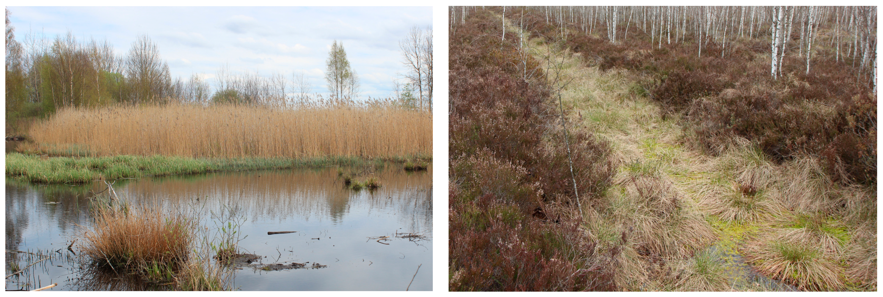
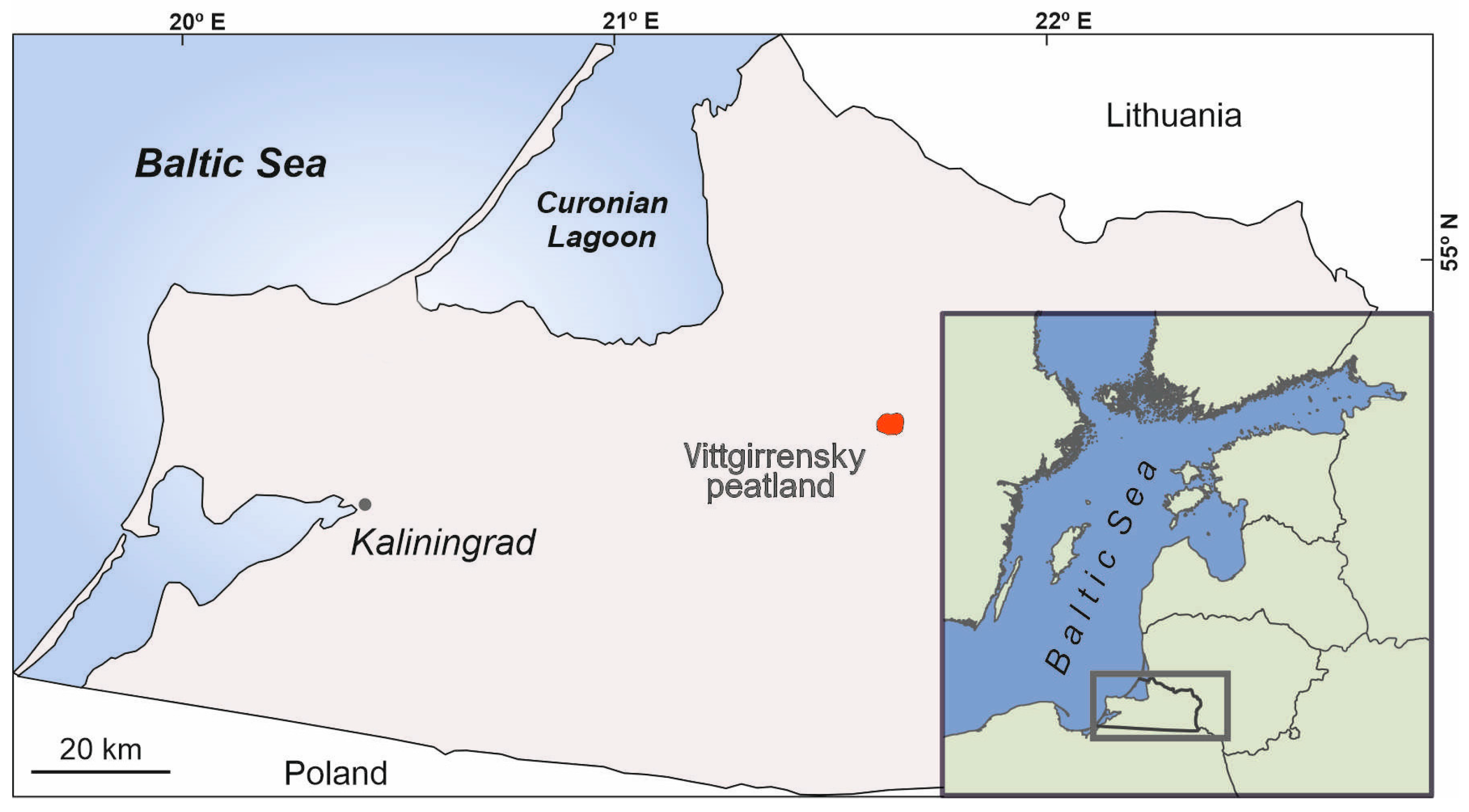
2.1. Study Site

The Vittgirrensky Peatland is located in the central part of Kaliningrad Oblast (Figure 1). The peatland area occupies 122 ha, representing a residual peat bed that remained after commercial peat extraction. Since 2021, the peatland has become a measurement area of the Rossyanka Carbon Supersite [8,9]. The territory is situated on the border of the boreal and nemoral zones and is characterised by an average annual air temperature of +7.8 °C and an average annual precipitation of 752 mm. The landscape of the study area is formed by rolling terrains of the glacial ground moraine (20–23 m above sea level) [10].
We do not provide a Digital Elevation Model in this paper as it is the subject of a separate investigation, but we analysed open data on the terrain elevation and topography. The Vittgirrensky peatland has a flat surface with a slight general slope in a northeastern direction. Most of the peatland is situated at a height of 18.5–19 m above sea level, while the edge zone is elevated to 20–21 m a.s.l. The highest site is located in the southwestern part of the peatland that reaches 22–23 m a.s.l., occupying the area where peat was not extracted.

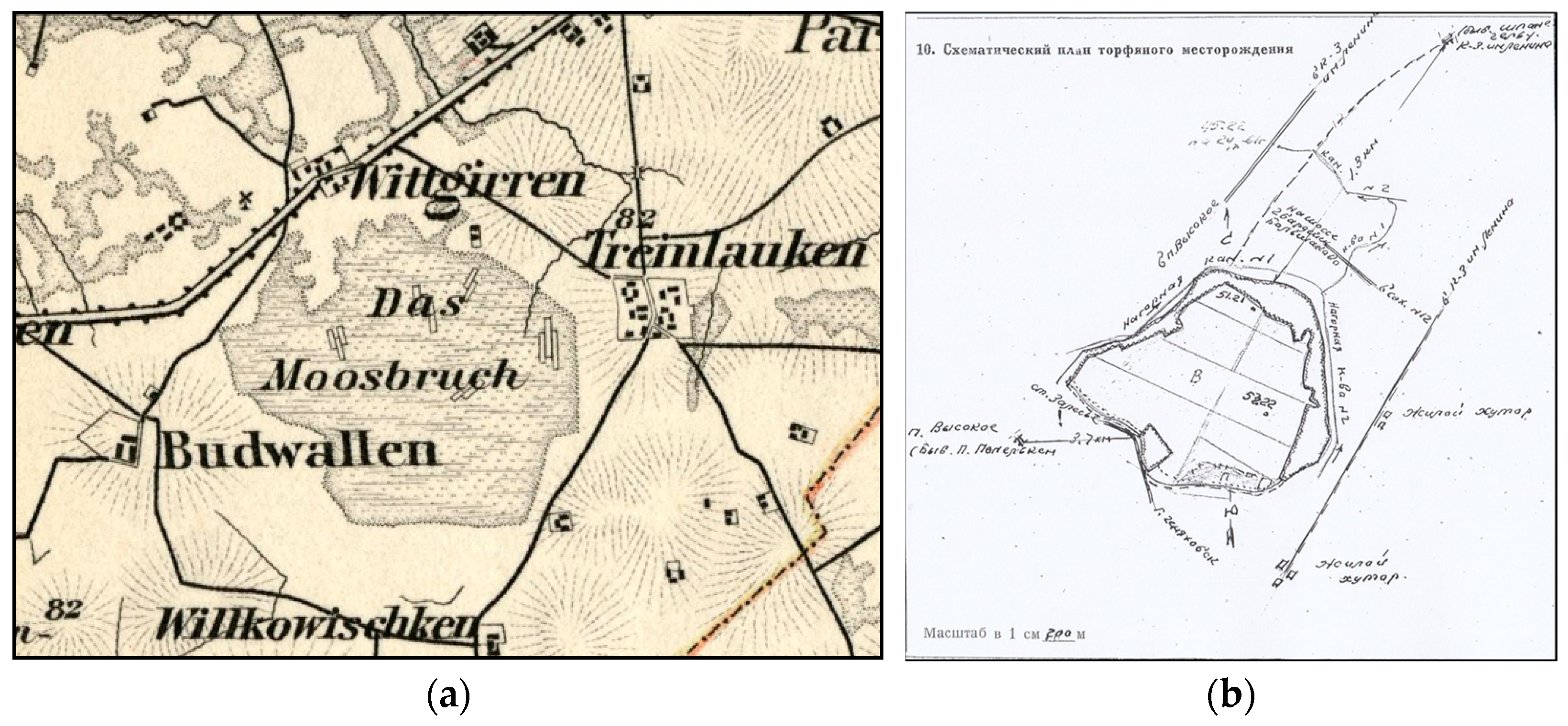
2.2. History of Land Use

A review of archival, cartographic, and literary data provides grounds to assume that the Vittgirrensky Peatland was a raised bog before drainage and peat mining, and that its exploration and development proceeded in several stages.
According to available old maps [18,19] and archived documents of the Geological Office [20,21], the edge zone of the bog was drained at the end of the 19th century (Figure 2a), and peat was mined by hand cutting.
After a full-scale inventory of peat deposits in the post-war period, the Vittgirrensky Peatland was included in the Peat Stock Cadastre of the Kaliningrad region [13] as a raised bog with an area of 98 ha, of which the commercial peat reserves an occupied 76 ha. The average peat depth was 3.00 m, while the thickest was 4.10 m. A more precise assessment of the peat deposit was made in 1961–1962 due to the plans for peat extraction (Figure 2b). This assessment gave 79.08 ha of commercial peat reserves consisting of fuscum-peat [21].
In the late 1970s and 1980s, the peatland was drained completely through a combined (open and closed) drainage system, and then commercial peat mining was started here using the milling method, except for the westernmost site of the peatland due to some technical and logistic reasons. The closed drainage system consists of underground corrugated plastic pipes and ceramic culverts (20 cm in diameter). The open drainage includes a network of narrow channels (up to 1 m deep) between the peat extraction fields and the trunk drainage channels. The peatland was abandoned after the peat extraction stopped in the late 1990s. Currently, the peatland is covered by regrowth communities that have developed after the destruction of the primary bog vegetation (Figure A1, Figure A2, Figure A3, Figure A4 and Figure A5). The peatland area and adjacent agricultural fields are drained, but the condition of the drainage system has deteriorated.

2.3. Field Survey

The research was carried out using a range of conventional methods. Soil morphology was described in the soil profiles and coring wells according to the national scheme [22], comparable with the international guidelines [23,24,25]. A total of 50 soil profiles and coring wells were established (Figure 3), from which 200 soil samples were taken to determine the chemical composition and moisture content. The soil and peat material have been sampled at 10 cm intervals from the retrieved cores, taking into account the boundaries between the horizons across the whole depth of the soil profile or coring well. Depending on the structure and main characteristics of the soil, the samples were collected using the Russian peat corer, the Edelman soil auger, or the Izmailsky soil auger. Additionally, 70 samples were taken from undisturbed deposits to measure soil bulk density using the cutting-ring method with 100 cm3 cylinders.
The soil profiles and coring wells extended to a depth that entirely exposed the residual peat bed and the upper layers of the underlying mineral deposits (in most cases 2.0 m). To clarify the boundaries of the peat deposits, a series of 57 additional coring and test pits (without sampling) was performed until the underlying mineral bed (0.5–2.0 m) was reached. The water table dynamics have been studied in the coring wells by direct measurements. The names of the soils are given according to the international World Reference Base (WRB) classification [26].

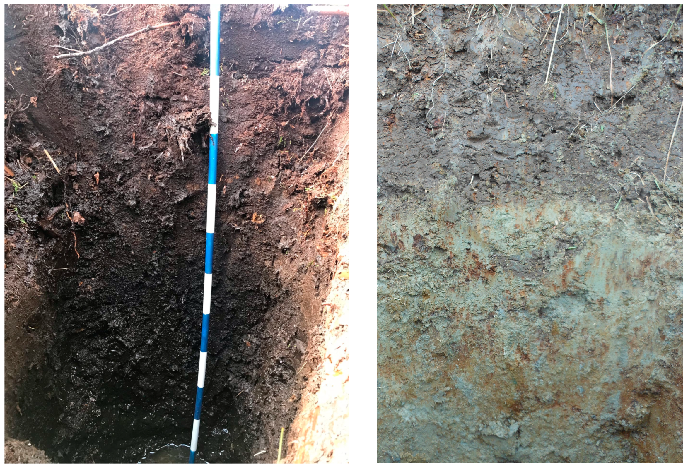
2.4. Measurements and Laboratory Treatment

The soil material was examined in the Chemical Testing Laboratory of the Immanuel Kant Baltic Federal University (Kaliningrad), in the Soil Chemistry Laboratory of the Kaliningrad State Technical University, in the Kaliningrad Agrochemical Service Centre, and in the V.V. Dokuchaev Soil Science Institute (Moscow).
The degree of peat decomposition was estimated by the ‘macroscopic’ field method according to the guidelines of V. Varlygin [27]. The soil solution chemistry (pHH2O, pHKCl) was determined by potentiometric measurements. The texture of the mineral deposits was studied using the standard pipette method with soil preparation by treatment with 4% Na4P2O7. Soil moisture content at field capacity and hygroscopic water content were determined via the oven drying (thermostatic-weight) method.
The ash content in the peat and muck samples was determined based on incineration in a muffle furnace PM-10 at 800 °C for two hours. The determination of total organic carbon (TOC) was performed using the dichromate oxidation method for the humus layers [28]. Total nitrogen was measured using the Kjeldahl method [29].
Soil samples were examined with four replications. Statistical analysis and a graphical summary of the data were performed using the software MS Excel 2016 and Grapher 19.1.288.

2.5. Soil Mapping Procedure

A sketch map of soils in the Vittgirrensky Peatland was performed by means of a comprehensive analysis of cartographic data, including a detailed aerial photographic plan of the site at a scale of 1:1000, ground truthing data, and the results of vegetation mapping [16]. All boundaries of soil units were identified from the in situ examination of soil morphology, moisture content (organoleptic determination), and degree of peat decomposition. In addition, the topography of the peatland is characterised by short, 0.5–0.7 m high ledges that separate old peat-cutting sites (zone of Gleysols) from the area of milled peat extraction (zone of Histosols). These ledges have been studied along their entire length and are considered to be the boundary between different soil units. Cartographic data capture and visualisation were performed using ESRI ArcGIS 10.0 software, including preliminary analysis and final mapping.

3. Results and Discussion

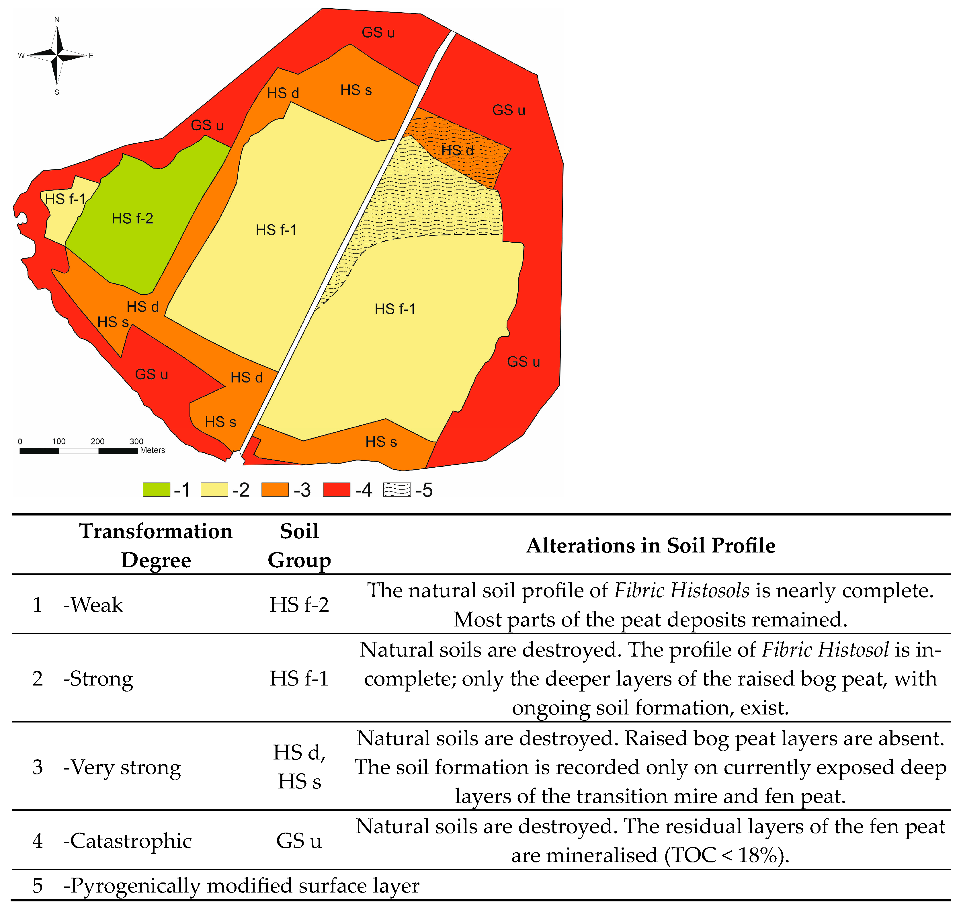
3.1. Spatial Distribution of Soils in the Vittgirrensky Peatland

The sketch map of soils (Figure 4) shows that the studied area includes five soil units that belong to two WRB reference soil groups [26]: Histosols and Gleysols (Figure A6).
Histosols occupy most of the study area but show an inhomogeneity in the occurrence of peat layers ranging from 0.35 to 2.15 m thick. The average thickness of the peat layer, with an organic carbon content of more than 20%, is 1.12 ± 0.08 m (coefficient of variation 34.9%). The main pattern of the soil cover is its concentricity, which reflects the intensity and direction of the mire formation process in the past as well as the present characteristics of the residual peat bed.
The central part is occupied by Fibric Histosols Drainic (HS f-1/HS f-2) with distinct layers of oligotrophic, mesotrophic, and eutrophic peat in their profile. This part is encircled by a narrow zone of Dystric Hemic Histosols (HS d), where a layer of oligo/mesotrophic peat reaches the maximum thickness. Small areas in the edge zone are occupied by Sapric Hemic Drainic Histosols (HS s) with an entire profile of less than 1 m, which consists of eutrophic fen peat. The peculiar site of the peatland, with the thickest layer of raised bog peat (up to 2.0 m), was found in the southwestern part. It has an overall thickness of about 2.5 m, with more than 90% oligotrophic Sphagnum peat (Table 1).
The margins of the peatland are occupied by Umbric Drainic Gleysols (GS u), which have no peat horizon. The humus horizon of these soils contains less than 18% organic carbon. The umbric horizon has an average thickness of 20 cm, and is directly underlain by the gley horizon.

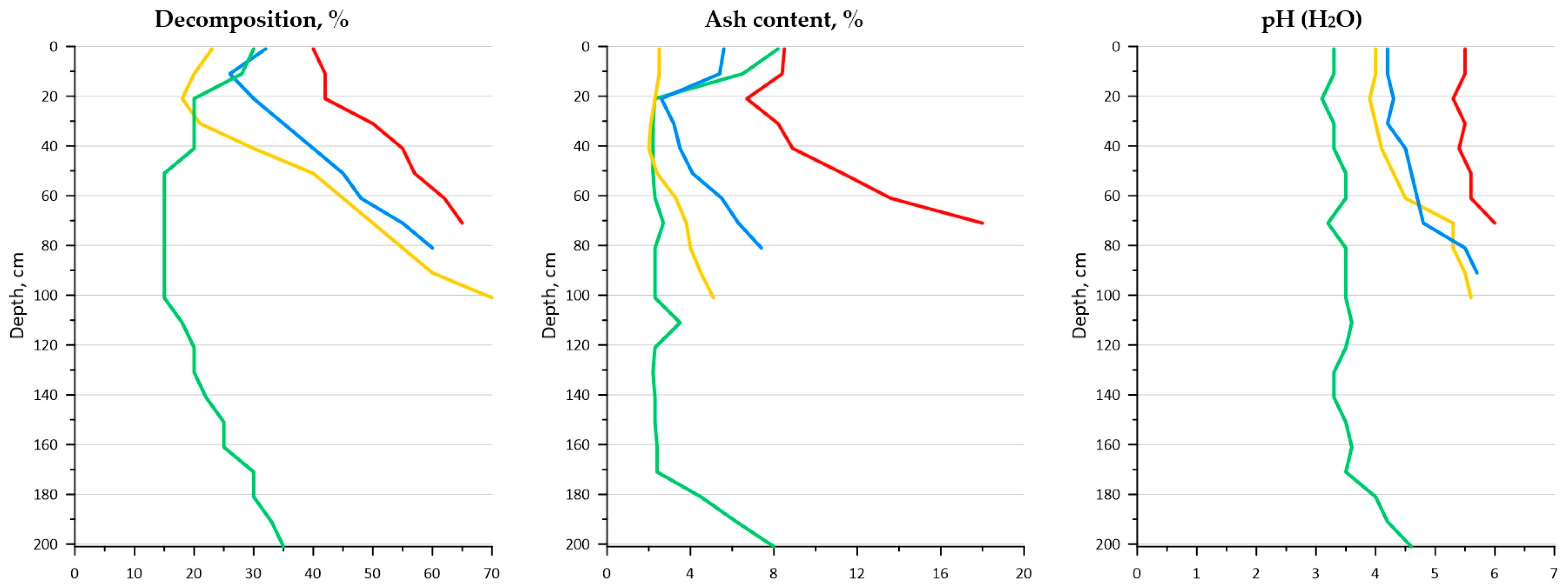
3.2. Ecological Characteristics of Soils

An analysis of a large set of data obtained for the Histosol profiles revealed a general feature for the radial differentiation of pH, ash content, and decomposition degree on the main part of the peatland, such as an increase in their values in the top–down direction (Figure 5). The changes in depth are determined by the different composition of organic residues during the transition from oligotrophic to eutrophic conditions.
The profile HS f-1 (Figure 5) represents Fibric Histosols (Drainic) that consist of three horizons of peat with different structures and compositions: the raised bog peat, the transition mire peat, and the fen peat, which successively replace each other in the soil profile. The horizons of the raised bog have a spongy and fibrous texture, low values of bulk density (0.07–0.12 g/cm3), total organic carbon content up to 54%, total nitrogen content of 0.5–0.8%, and a degree of decomposition of 15–25%. The peat is highly acidic, with low ash content and very high water content (the absolute water content is 1200–1600% at the saturation point; the relative water content exceeds 90%). The upper layers of Sphagnum fuscum-peat are characterised by the minimum values of density, ash content, and degree of decomposition. They are underlain by the layers of Sphagnum–Eriophorum peat, where these parameters increase.
The transition mire peat layers, with the herbaceous-moss composition, are located at depths of 40–75 cm. The degree of decomposition is 40–50%. These horizons are saturated over field capacity and include free bog water during the wet season (winter or early spring). The ash content is 3–5%, but pH values are higher than in the oligotrophic horizons (Figure 5). The bulk density is 0.07–0.12 g/cm3. The absolute water content of soil varies considerably (from 800 to 1200%), and the relative water content is 89–92%.
The layers of the fen peat are found from depths of 70–90 cm. Their characteristic features are a high degree of decomposition (>60%), black colour, and a mucky consistency. In most cases, they contain bog water. The dominating macrofossils are fragments of the alder wood and cork tissues, rhizomes, and rootlets of Phragmites and sedges. The thickness of the fen peat horizon is 10–30 cm, and then it is replaced, via a gradual transition, with a thin organic-matter-stained (organo-mineral) layer. The fen peat generally shows a slightly acidic pH range (4.7–5.8), being herewith a geochemical barrier where acidic solutions from the overlying peat horizons meet the neutral environment of the upper part of the underlying mineral deposits. This fact explains the shift in pH values. The absolute water content varies between 700 and 900%. The bulk density is 0.12–0.16 g/cm3.
The ash content of the fen peat is, in most cases, 3.5–4% but can be higher as it depends on the botanical composition of the peat. Approaching the mire kettle floor, the ash content increases due to the fine mineral admixture of the silt.
Whereas the organic matter content is lower in the fen peat (92–95%) compared to the raised bog peat and transition mire peat, the total organic carbon value is slightly higher due to the intensive humification. The value of total nitrogen content also reflects a distinction between the peat horizons of different geneses in the soil profile (from 0.5% in oligotrophic peat and 1.2% in eutrophic peat).
The profile HS f-2 (Figure 5) represents Fibric Histosols in the unmined part of the peatland. It is characterised by a significant thickness of the oligotrophic peat, while the layers of the mesotrophic and eutrophic peat are thin and indicate a rapid fen–bog transition in this area.
The profile HS d reflects the properties of Dystric Hemic Histosols that include only two horizons of the oligo/mesotrophic and eutrophic peat (Table 1). Their characteristics are similar to those described for Fibric Histosols (HS f-1).
The profile HS s represents Sapric Hemic Eutric Histosols found in the edge zone of the Vittgirrensky Peatland. It has the following characteristics: the relative water content of the soil is 80–83%, the absolute water content is 400–500%, the bulk density of the peat horizon is within the range of 0.15–0.45 g/cm3, the organic carbon percentage is 52.5–54%, and the concentration of the total soil nitrogen varies from 0.9 to 1.9% (Figure 5). The pH level depends on the composition of the peat: in the ligneous–herbaceous peat, it is lower compared to the ligneous (alder) peat. The pH values increase in the top–down direction, while, within the peat horizons, the pH level lies in a range from slightly acidic to neutral values. The alder peat also shows increased values of ash content and an admixture of silty particles compared to the herbaceous peat.

3.3. Spatial Distribution of Underlying Sediments

The studied peatland is situated within an agricultural landscape on Umbry-Gleyic Albeluvisols (Aric, Drainic, Loamic, Siltic), underlain by the moraine boulder-rich carbonated or leached (carbonate-free) loams, loamy sands and clays. The mire kettle floor lies at depths 80–130 cm under the residual peat bed. Some soils at the edge zone are also underlain by moraine gravelly (10–70 mm) carbonated deposits that contain 24.3% of the clay fraction and equal proportions of sand (38.6%) and silt (37.0%). We found that moraine gravelly carbonated material may have been assigned to a textural group between clay loams and loams.
In the central part, the underlying sediments have a different genesis. The particle size of limno-alluvial deposits varies here from loams to silty clay. Below, these deposits are underlain by fluvioglacial sands. The underlying sedimentary material is, thus, heterogeneous at a depth of 1.2–2.0 m in the main part of the peatland (Figure 4).
Soil carbonates are widespread in the underlying mineral deposits below 150 cm throughout the whole study area, varying in some areas from 130 to 170 cm. All carbonate layers are gleyed and characterised by a carbonate–hydrocarbonate system forming in the hypergenesis zone [30]. The contact of peat and carbonated mineral deposits (or waters) causes the saturation of peat layers with Ca2+ ions and the neutralisation of organic acids.
Carbonates may occur as continuous impregnations in clay (in most cases) or as limestone fragments of different sizes (in loams and sandy loams). The pH level increases in the carbonate-bearing horizons from slightly alkaline values (7.5–7.8) at a depth of 150–170 cm to alkaline values (8.1–8.4) within the layer of 180–200 cm.
Thus, we see a contrasting change in pH within 2 m of the soil profiles: from strongly acidic values in the upper oligotrophic peat horizons to slightly acidic values in the horizons of the eutrophic peat, and then a transition to alkaline values in the carbonate layers of the underlying mineral deposits.

3.4. Anthropogenic Transformation of the Soil Cover

During more than one hundred years of exploration and land use, the Vittgirrensky Peatland underwent impacts of varying intensity and spatial coverage. Studying its present-day soil cover provides new insights to reconstruct the main stages of the bog anthropogenic degradation, which are reflected in the degree of transformation of the natural soil profile.
The first stage began at the end of the 19th century, when drainage was performed in the peripheral part of the bog, and peat extraction was organised there using the cutting method. After cutting, the deeper layers of the mesotrophic peat were exposed to aeration, which induced their hydrothermal degradation. The transformation did not affect the main part of the bog but caused some decreases in the water table and birch coppice invasion. The second stage started in the 1970s after drainage in the central part of the peatland and further peat milling that destroyed the natural bog soils (ca. 2 m thick peat layer cut). On the cut-over edge sites, the residual peat layers underwent mineralisation. The third stage is considered post-technogenic (from the 1990s to the present). It is characterised by soil formation on the exposed deep peat horizons, a residual effect of drainage systems, and the hydrothermal and pyrogenic degradation of the surface peat layers. The anthropogenic transformation of soils is presented on a sketch map (Figure 6), which was compiled after identifying the degree of preservation of the natural bog soil profile in different parts of the Vittgirrensky Peatland.
In the spatial aspect, the preservation of the residual oligotrophic peat layers, after the industrial milling, depends on the initial thickness of the peat deposit. As the thickest peat deposits (more than 3 m) were in the central part of the peatland, a thin layer of oligotrophic peat (ca. 40 cm) remained here after cutting. At present, Fibric Histosols Drainic (HS f-1) are found in this area (Table 1). The southwestern site of the peatland (HS f-2, Figure 4) is the only area that has not been subjected to peat cutting and thus preserved a complete soil profile.
Dystric Hemic Histosols (HS d) and Sapric Hemic Eutric Histosols (HS s) formed from the residual peat in the areas where oligotrophic layer was completely cut down.
An important distinguishing feature of the organogenic soil is the pyrogenic remains on its surface that indicate the occurrence of periodic fires as a factor of post-technogenic soil degradation. The pyrogenic transformation of the peat layer is most pronounced in the northeastern part of the carbon polygon, where a specific soil patch has been identified (Figure 4 and Figure 6). The pyrogenic degradation has affected the 5 cm thick surface layer of the raised bog peat, where macromorphological evidence (pyrogenic black crusts) and changes in the chemical composition of the peat have been recorded in the places of fire spread. Primarily, the ash content increases abruptly up to 5–15% (depending on the degree of pyrogenic impact) in the layer of 0–5 cm. In the layers affected by fires, total organic carbon decreases while total nitrogen reaches the peak values (up to 1.3–1.5%), which may be considered as a specific indicator for pyrogenic impact in the analysis of the chemical composition of raised bog peat. The fires are most likely caused by the annual spring burning of dry plant residues on the adjacent agricultural land.

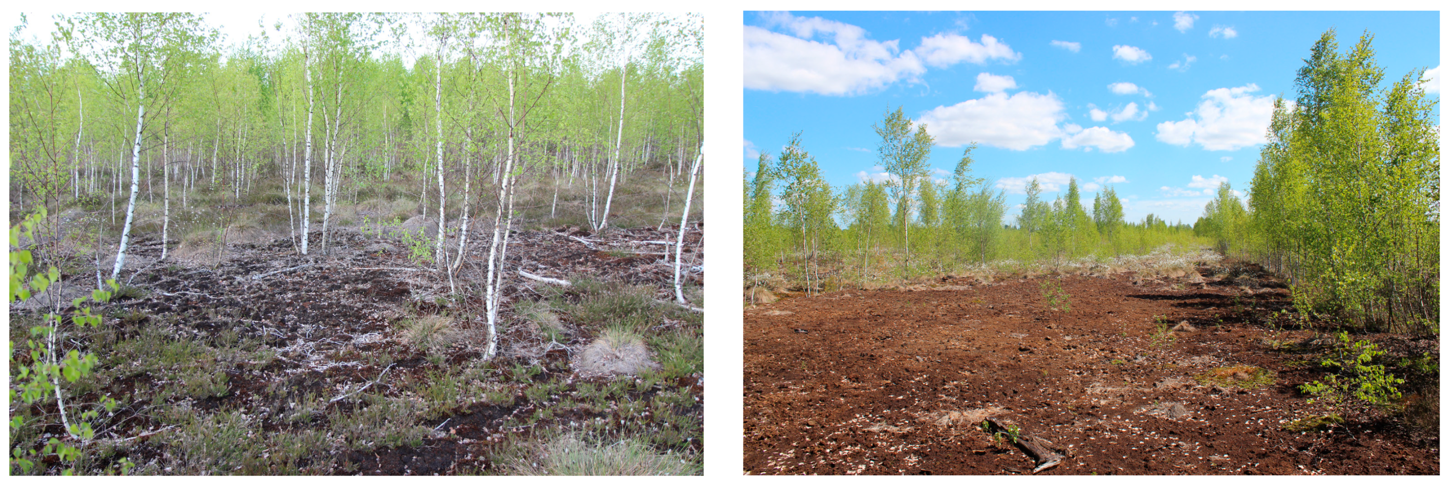
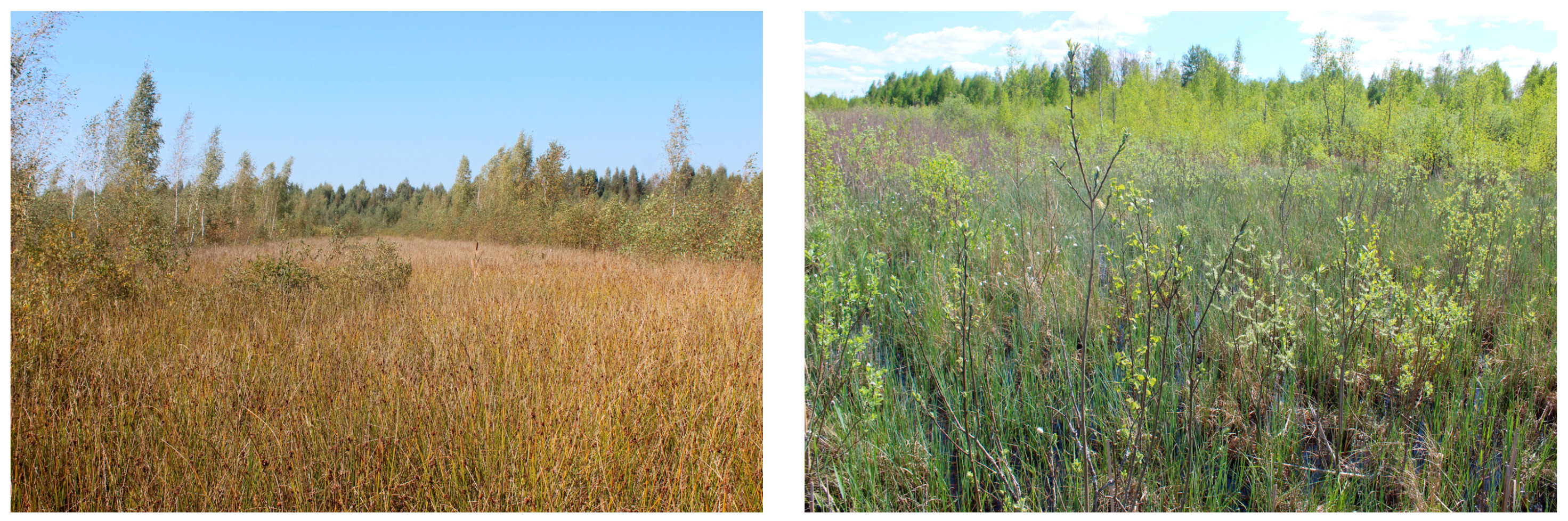
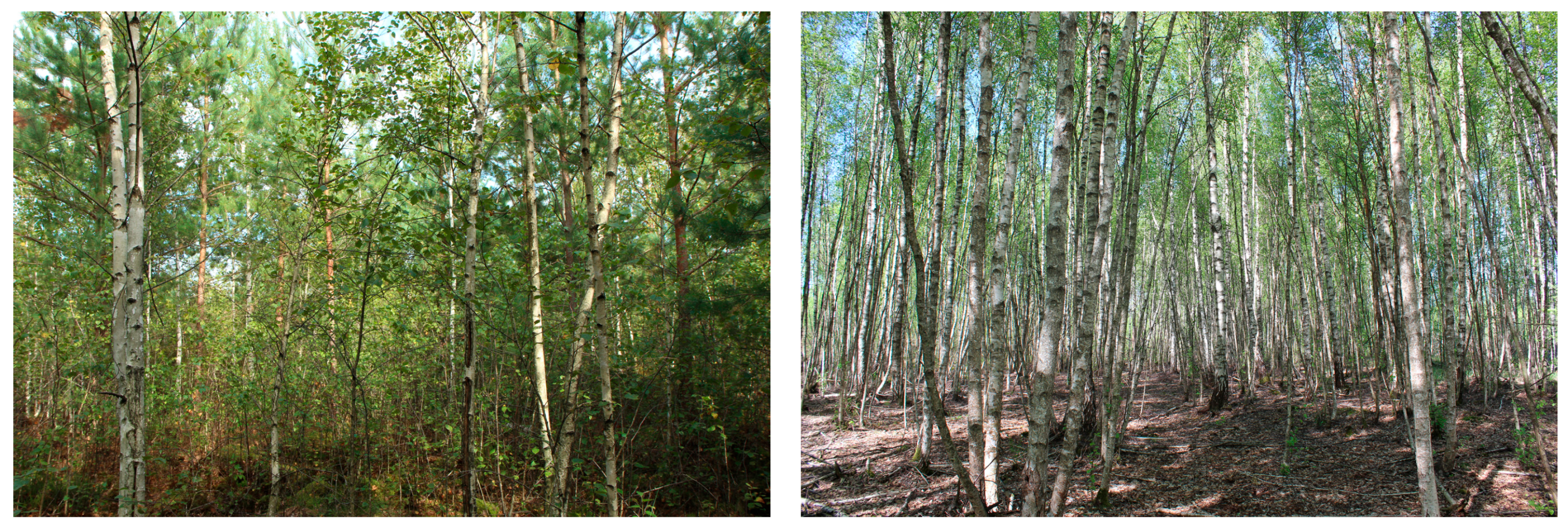
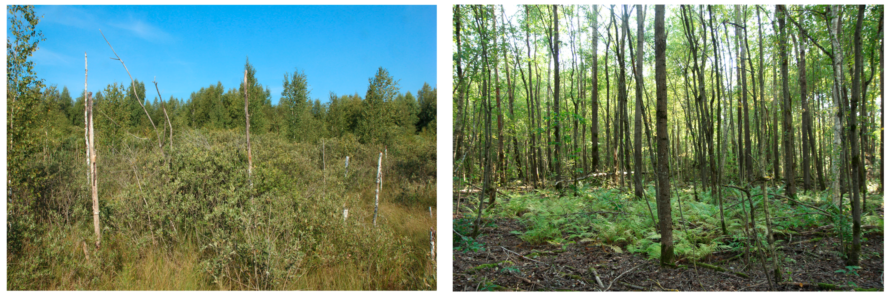
3.5. Relationship between Present-Day Soils and Vegetation Cover

Since vegetation cover at the scale being considered here is largely determined by soil properties, we have matched the outlines of the soil units (Figure 4) with a map of peatland vegetation [16]. Although the distribution of soils does not coincide with the boundaries of vegetation units, we could see the relationship between certain plant community categories and certain types of soil (Figure 7). Table 2 shows the main types of vegetation cover related (see also Figure A1, Figure A2, Figure A3, Figure A4 and Figure A5) to the present-day soil units in the Vittgirrensky Peatland and the dominating plant species of the ground layer, indicating the properties of the upper soil horizons and their hydrological features. It is remarkable that each soil type includes plant communities of different species compositions, which are associated with the different hydrological regimes on various sites within one soil unit.
Another important point in the context of mire restoration is the distribution of the so-called mire ‘true’ species [31]. For this purpose, we have divided all plant species into groups according to the degree of their ‘fidelity’ to the mire ecotope based on the scale of Botch and Smagin (Table 2) that was proposed for mires in the northwest of Russia [31] and updated taking into account the regional mire characteristics [11]. The mire ‘true’ species, with ‘fidelity’ ranks III-V, are given in Table 2 for each type of vegetation within each soil reference group.
Moistening is, apparently, a basic factor determining the distribution of mire species, but the presence of a peat layer also plays an important role. The highest percentage of mire ‘true’ species was recorded in the wet fen-like communities and drainage ditches, as these ecotopes are distinguished by a combination of a high water-table level, a longer wet period, and a certain thickness of the peat layer. It is noteworthy that they show the least development or complete absence of the tree layer, while an abundance of Sphagna dominates in the ground cover. In all other sites of the peatland, Sphagnum species are found only in scattered small turfs or are completely absent.
The sites with the oligotrophic raised bog peat show the maximum mire species diversity. Nevertheless, the HS f-2 unit, where the thickest but strongly drained layers of the raised bog peat are located, has a very low floristic diversity and a small number of mire ‘true’ species despite the absence of peat cutting. It confirms the leading role of the moistening factor.

3.6. The Role of Present-Day Soils in Bog Vegetation Recovery

As follows from Table 2, each soil group includes areas with different potentials for bog vegetation recovery. Among the main factors, we identify soil properties, hydrology, and the development of peat-forming Sphagnum species. Our studies show that a combination of these factors can either promote or impede the vegetation recovery process in the peatland (Table 3).
Soil properties. The physical and electrochemical properties of Fibric Histosols are usually favourable for mire soil formation revival on cut-over peatlands, which is typical of the environments in the Eastern Baltic Region [32]. The pH values of their upper peat horizon are, in most cases, strongly acidic, which matches the ecological preferences of the peat-forming Sphagnum mosses [33]. The trophic level and ash content also match the ecological optimum of the peat substrate. The low bulk density and high porosity of the residual peat layer are favourable physical bases for water saturation in the profile of Fibric Histosols (HS f-1/HS f-2).
Hydrological regime. One of the main obstacles to active bog ecosystem recovery is the unstable water table, which varies on average from 20–30 cm in winter and early spring to 50–60 cm in summer and autumn. This results in the exposure of more than half of the HS f-1/HS d profile to aeration during the warm period, activating the process of peat destruction and increasing its decomposition degree, especially in the horizons of mesotrophic and eutrophic peat.
In some areas of Fibric Histosols (HS f-1/HS f-2) and Dystric Hemic Histosols (HS d), a decline in the level of the water table to 70–80 cm during the dry periods resulted in the capillary-fringe truncation, desiccation of the surface layers of peat (moisture content less than 60%), and led to their hydrophobic conditions and a fire hazard. Therefore, a critical decrease in water table level, due to the combined effect of drainage systems and dry weather conditions, leads to the hydrothermal and pyrogenic degradation of Histosols as well as increased greenhouse gas emissions.
This problem is even more acute for a weakly disturbed site in the southwestern part of the peatland (HS f-2). Due to its higher location, compared to the main part of the peatland, it has the deepest records of the water table (80–110 cm) from June to October, which has led to the increased degree of decomposition in the upper soil horizon (oligotrophic fuscum-peat) of more than 30%. Hence, there are no conditions for spontaneous bog vegetation recovery in this area since Fibric Histosols (HS f-2) are at the stage of progressive hydrothermal degradation.
Occurrence of peat-forming Sphagnum species. Since the natural ecosystem of the Vittgirrensky Peatland was represented by an active raised bog in the past, the reestablishment of the peat-forming Sphagnum cover is of the greatest importance in the context of mire restoration activity. Moreover, Sphagnum mosses are arguably the most important peat-forming plants worldwide [34]. Thus, the diversity and abundance of Sphagnum species are the basis for the mire rehabilitation programme in the study area. However, the regenerative capacity and recovery potential of Sphagnum species are different. A study of mire restoration in European regions [4] shows that only certain species of Sphagnum (in particular, Sphagnum cuspidatum) spontaneously recolonise the rewetted sites, whereas, for most species of bog lawns and hummocks, reintroduction activity is required, including the search of diaspore sources, cultivation, and repatriation to communities.
In spite of the fact that 11 Sphagnum species are common in the peatland area, the soil-forming role of Sphagna is still insignificant to Histosols due to their very scattered distribution in plant communities. Most species (Sphagnum capillifolium, S. fallax, S. fimbriatum, S. fuscum, S. magellanicum, S. riparium, S. teres) are found occasionally in a small amount. Significant areas are occupied only by Sphagnum cuspidatum. Species such as Sphagnum angustifolium, S. centrale, and S. squarrosum are also quite common, forming relatively large sods or clumps. The latter four species are associated with small, inundated depressions or drainage ditches, where the thickness of the fresh Sphagnum peat is already 5–10 cm.
So, we can assume that the existing species diversity of Sphagna and improved hydrological conditions in the residual raised bog peat soils can provide recolonisation in the central part of the peatland by Sphagnum communities, without additional reintroduction.
In general, the successful restoration of bog vegetation requires raising the water table, which can provide a moisture content in the surface layer of Fibric Histosols (HS f-1/HS f-2) and Dystric Hemic Histosols (HS d) of over 76% during the dry seasons of the year [35]. This is the basic condition for creating a favourable hydrological regime. Meanwhile, in our case, the recovery of the raised bog communities is most likely in the central part of the study area. The peatland margins can only be restored to the fen ecosystem, as having no peat layer or only a thin layer of the eutrophic peat underlain by the carbonated mineral deposits.

3.7. Site Rewetting Potential

Regarding the combination of various factors that may have been essential for the mire rehabilitation process, we have identified several types (groups) of sites according to their recovery potential in the case of rewetting at the Vittgirrensky Peatland (Table 4, Figure 8). We also indicate the most likely habitat to be expected as a result of this rewetting management (according to the EUNIS classification [36]). Since data on the spatial location of soils are one of the crucial factors for rewetting potential, the soil-type labels are provided for each unit in Figure 8.
Site 1 (a rapid recovery of the raised bog communities is expected). The most favourable conditions for rapid distribution of the Sphagnum cover and peat formation exist only within a small, relatively wet area in the southern part of the peatland (Figure 8). It is confined to Fibric Histosols (HS f-1) with low pH values, a shallow water table, and a wide variety of Sphagna, among which there are raised bog species forming multiple micro-topography elements. This combination of factors seems to be very important for regenerating the peat formation and reestablishing the raised bog communities. The main efforts of rewetting management should aim at stabilising and maintaining the optimal water table level.
Site group 2 (recovery of the raised bog and transition mire communities is expected in the medium term). Conditions for the expansion of Sphagnum cover and peat formation are only partially favourable. Despite a significant percentage of mire ‘true’ species and a variety of Sphagna, only one species—Sphagnum cuspidatum—occupies an extensive area here, forming large mats in drainage ditches and within a small wet area with a thin layer of the fen peat in the northern part of the peatland. However, as the experience of peatland restoration shows [3,37], such communities can stabilise and exist for a long time as a successional stage without peat formation due to contrasting hydrological conditions (essential drying or prolonged flooding). Reducing water table fluctuations to shallow and only short-term flooding may enhance the invasion of the other Sphagnum species and successive expansion of Sphagnum cuspidatum mats to nearby areas. A century-old study by Gams and Ruoff [38] showed that, under favourable conditions, this Sphagnum species can rapidly fill the ditch with its biomass and spread beyond it. The high pH level in a thin layer of the fen peat and the influence of groundwater will probably limit the development of raised bog communities (except in bog hollows). Transition mire or/and poor fen communities are more likely to reestablish here during the restoration activities.
This group of sites also includes a large area in the peatland centre, located on the abandoned peat extraction fields on Histosols with the residual raised bog peat (HS f-1). Here, several Sphagnum hummock species were found in scattered small tufts. A rise in the water table during rewetting may induce the further distribution of Sphagna in the numerous depressions between cotton grass tussocks, facilitating the recovery of the transition mire communities. However, mire rehabilitation activity in this area will require addressing the pyrogenic mineralisation in the upper peat layer and root water uptake by the birch coppice.
Site group 3 (recovery of the bog and transition mire communities is expected in the long term). These sites are very different in physiognomy, but, in most sites, they are underlain by a thick layer of strongly desiccated raised bog peat (HS f-2). Under existing conditions, spontaneous mire vegetation recovery is unlikely to be expected. Mire restoration management will require, except for rewetting, some additional measures to facilitate the recolonisation of the area. As was noticed in the earlier studies [3], the natural regeneration of Sphagnum usually does not occur on bare peat; therefore, the reintroduction of Sphagnum propagules is envisaged here, probably, after a sufficient distribution of Eriophorum tussocks, which is currently observed in some places. The sites with dense birch regrowth also require the elimination of tree biomass, and, maybe, topsoil removal (the layer of highly mineralised raised bog peat). Communities most likely to be restored here are transition mire associations dominated by Eriophorum. The development of the micro-topography and recovery of the raised bog communities seem to be a long-term process in this part of the peatland.
Site group 4 (recovery of the fen communities is feasible in the medium or long term). These sites occupy the edge zone of the peatland, where peat was mined in the past by hand cutting. At present, the peat layer is absent here, but the area is characterised by a shallow water table, and a number of mire ‘true’ species have been recorded. As was observed in some studies [39,40], fen vegetation may develop in cases when the peat layer has been completely removed from the cutaway peatland. This process is mainly affected by soil and water properties. In our study site, we consider the recovery of the fen communities as being possible, though a peat-forming process is envisaged but only of low intensity.
Site group 5 (the mire restoration is presumably feasible). The sites are located on the periphery of the peatland on thin Histosols (HS d and HS s) that have been significantly altered due to strong drainage and the development of a proper forest, or due to flooding and the formation of long-term water bodies (also due to beaver activity). Many earlier investigations in other regions [41,42,43] show that drainage, peat mineralisation, and increased shading usually stimulate dramatic changes in vegetation on peat soils, especially in the ground layer. Birch volume might also become an impeding factor for the rewetting [44]. The experience of mire rehabilitation in the neighbouring Baltic countries [45] showed numerous difficulties during restoration activities on such drained sites, even with the elimination of trees and the moss-transfer technique [46]. Nevertheless, the soil properties in this area make mire restoration potentially feasible. However, rewetting management seems to be a time-consuming and expensive project. The start of mire rehabilitation here is appropriate only after a successful rewetting of the other sites of the peatland.
Site group 6 (the mire rehabilitation is doubtful). These sites occupy the outskirts of the mire depression, where the peat layer is absent. The lack of documentary data does not provide an understanding of whether peat-forming communities existed here before or not. Due to the combination of many unfavourable factors, the recovery of peat-forming communities is unlikely to be possible here, though successful rewetting management can induce local development of the fen communities or a paludified forest in the future.
It is important to note that the rewetting potential of different sites does not coincide with the transformation degree of their soil profile (Figure 6), as this transformation is mainly caused by a very complicated and often unfavourable hydrological regime. As a result, the sites with a completely preserved soil profile (HS f-2) have a rather weak potential for mire rehabilitation at present, whereas some areas with strongly transformed soil profiles—in particular, inundated patches with fen-like communities—show good conditions for bog recovery.
Thus, the properties and heterogeneity of the present-day soil cover show a different potential for mire vegetation recovery in the different parts of the Vittgirrensky Peatland. Soil cover determines different time periods and encourages the application of different approaches to restoration management during mire rehabilitation activities on the Rossyanka Carbon Supersite.

4. Conclusions

1. We identify the present-day soils of the Vittgirrensky Peatland as referring to two WRB groups: Gleisols and Histosols. The spatial distribution of soil units is concentric. Gleisols occupy the edge zone, where a thin residual peat layer (modern-day umbric horizon) is completely mineralised. Histosols were formed from the currently existing residual layers of peat; they change successively from the periphery to the centre of the peatland as follows: Eutric/SapricHemicDystricFibric.
2. The Histosol profiles show different values of indicators such as pH, ash content, and the degree of decomposition, which are associated with the structure and composition of the ancient peat horizons exposed to aeration after peat extraction, and then undergo a new stage of soil formation. The places of shallow peat are also influenced by the carbonated underlying sediments.
3. Most Histosols are characterised by hydrothermal degradation in the upper layers with patches of pyrogenic degradation. These processes significantly increase the risk of enormous greenhouse gas emissions from the peatland area, which requires elaboration following the rewetting strategy.
4. Each soil group includes plant communities of different compositions, which are associated with different hydrological regimes within one soil unit. The inundated sites with the oligotrophic peat show the maximum diversity of the mire ‘true’ species. These sites show good potential for the bog rehabilitation process, as they have favourable environmental conditions for Sphagnum growth and peat-forming recovery. Meanwhile, most peatland sites require a rise in the water table and complex rewetting management.
5. Based on the properties of present-day soils and differences in their occurrence, we have identified six groups of sites with different ecological and time-span potentials for mire community restoration during the implementation of rewetting activities. The scheme used to assess the cutover peatlands could contribute to the development of restoration projects for other disturbed wetlands.
6. The rewetting feasibility of the peatland’s sites does not coincide with the transformation degree of their soil profile. Due to a strongly unfavourable hydrological regime, the sites with a completely preserved soil profile have a weak potential for mire rehabilitation at present, and vice versa. On the other hand, the integration of soil, hydrology, and vegetation data allows for the relevant identification of site rewetting potential within the spatial heterogeneity of both soil and vegetation cover.

Author Contributions

Conceptualization, O.A. and M.N.; methodology, O.A. and M.N.; software, T.N.-D.; investigation, O.A. and M.N.; data curation, O.A. and M.N.; writing—original draft preparation, O.A. and M.N.; writing—review and editing, O.A., M.N. and T.N.-D.; visualization, O.A., M.N. and T.N.-D.; supervision, O.A. and M.N. All authors have read and agreed to the published version of the manuscript.

Funding

The research was supported by the State Assignment of the Ministry of Science and Higher Education of the Russian Federation, theme No. FZWM-2023-0002. The manuscript was prepared with support from the project ‘Restoring Peatlands in Russia—for fire prevention and climate change mitigation’ financed under the International Climate Initiative (IKI) of the German Federal Ministry for the Environment, Nature Conservation and Nuclear Safety (BMU), facilitated through the German Development Bank KfW and implemented by Wetlands International in partnership with the Institute of Forest Science, Russian Academy of Sciences, the Michael Succow Foundation and Greifswald University in cooperation with the Ministry of Natural Resources and Environment of the Russian Federation.

Data Availability Statement

All relevant data sets in this study are described in the manuscript.

Acknowledgments

The authors thank the anonymous reviewers of earlier versions for their valuable comments and suggestions.

Conflicts of Interest

The authors declare no conflict of interest.

Appendix A

Figure A1. Vegetation cover in the central part of the Vittgirrensky Peatland (on fibric Histosols, HS f-1): birch coppice on pyrogenically modified peat substrate (left) and bare peat site (right).
Land 12 01880 g0a1
Figure A2. Fen-like communities on inundated sites in the Vittgirrensky Peatland: Juncus-dominated, HS-d (left) and Carex-dominated, HS f-1 (right).
Land 12 01880 g0a2
Figure A3. Arboreal vegetation on severely drained sites in the Vittgirrensky Peatland: dense closed-canopy stand, HS f-2 (left) and dry birch forest, HS d (right).
Land 12 01880 g0a3
Figure A4. Vegetation on Gleysols (GS u) in the edge zone of the Vittgirrensky Peatland: wet shrubland (left) and wet forest with birch and aspen (right).
Land 12 01880 g0a4
Figure A5. Hydrophilic communities in the Vittgirrensky Peatland: reed beds (left) and Sphagnum lawn with Eriophorum in a drainage ditch (right).
Land 12 01880 g0a5
Figure A6. The soil profile of Histosols (left), occupying the main part of the Vittgirrensky Peatland, and Gleysols (right) from the edge zone of the study area.
Land 12 01880 g0a6

References

  1. Tubiello, F.N.; Biancalani, R.; Salvatore, M.; Rossi, S.; Conchedda, G. A worldwide assessment of greenhouse gas emissions from drained organic soils. Sustainability 2016, 8, 371. [Google Scholar] [CrossRef]
  2. Joosten, H.; Sirin, A.; Couwenberg, J.; Laine, J.; Smith, P. The Role of Peatlands in Climate Regulation. In Peatland Restoration and Ecosystem Services: Science, Policy and Practice; Bonn, A., Allott, T., Evans, M., Joosten, H., Stoneman, R., Eds.; Cambridge University Press: Cambridge, UK, 2016; pp. 66–79. [Google Scholar] [CrossRef]
  3. Poschlod, P.; Meindl, C.; Sliva, J.; Herkommer, U.; Jäger, M.; Schuckert, U.; Seemann, A.; Ullmann, A.; Wallner, T. Natural revegetation and restoration of drained and cut-over raised bogs in Southern Germany—A comparative analysis of four long-term monitoring studies. Glob. Environ. Res. 2007, 11, 205–216. [Google Scholar]
  4. Andersen, R.; Farrell, C.; Graf, M.; Muller, F.; Calvar, E.; Frankard, P.; Caporn, S.; Anderson, P. An overview of the progress and challenges of peatland restoration in Western Europe. Restor. Ecol. 2017, 25, 271–282. [Google Scholar] [CrossRef]
  5. Bonn, A.; Allott, T.; Evans, M.; Joosten, H.; Stoneman, R. (Eds.) Peatland Restoration and Ecosystem Services: Science, Policy and Practice; Cambridge University Press: Cambridge, UK, 2016; pp. 1–493. [Google Scholar] [CrossRef]
  6. Joosten, H.; Tapio-Biström, M.-L.; Tol, S. Peatland—Guidance for Climate Change Mitigation through Conservation, Rehabilitation and Sustainable Use; FAO and Wetlands International: Rome, Italy, 2012; pp. 1–100. [Google Scholar]
  7. Minayeva, T.Y.; Bragg, O.M.; Sirin, A.A. Towards ecosystem-based restoration of peatland biodiversity. Mires Peat 2017, 19, 1–36. [Google Scholar] [CrossRef]
  8. The Rossyanka Carbon Polygon. Scientific and Educational Project for Climate Active Greenhouse Gas Study. 2023. Available online: http://rosyanka.kantiana.ru/ (accessed on 2 July 2023). (In Russian).
  9. The Ministry of Science and Higher Education of the Russian Federation. Carbon Supersites: Russian Federation. 2023. Available online: https://carbon-polygons.ru/en/ (accessed on 2 July 2023).
  10. Romanova, E.A.; Vinogradova, O.L.; Frizina, I.V. Modern Landscapes in the Kaliningrad Region. In Terrestrial and Inland Water Environment of the Kaliningrad Region; Gritsenko, V.A., Sivkov, V.V., Yurov, A.V., Kostianoy, A.G., Eds.; The Handbook of Environmental Chemistry; Springer: Cham, Switzerland, 2018; Volume 65, pp. 97–119. [Google Scholar] [CrossRef]
  11. Napreenko, M.G. The Flora and Vegetation of the Raised Bogs in the Kaliningrad Region. Ph.D. Thesis, Immanuel Kant Baltic Federal University, Kaliningrad, Russia, 22 November 2002. (In Russian). [Google Scholar]
  12. Tanneberger, F.; Tegetmeyer, C.; Busse, S.; Barthelmes, A.; Shumka, S.; Moles Mariné, A.; Jenderedjian, K.; Steiner, G.M.; Essl, F.; Etzold, J.; et al. The peatland map of Europe. Mires Peat 2017, 19, 1–17. [Google Scholar] [CrossRef]
  13. Olenin, A.S. (Ed.) The Peat Stock Cadastre of the Kaliningrad Region; USSR: Moscow, Russia, 1952; pp. 1–63. (In Russian)
  14. Sirin, A.; Medvedeva, M.; Korotkov, V.; Itkin, V.; Minayeva, T.; Ilyasov, D.; Suvorov, G.; Joosten, H. Addressing peatland rewetting in Russian Federation climate reporting. Land 2021, 10, 1200. [Google Scholar] [CrossRef]
  15. Swenson, M.M.; Regan, S.; Bremmers, D.; Lawless, J.; Saunders, M.; Gill, L.W. Carbon balance of a restored and cutover raised bog: Implications for restoration and comparison to global trends. Biogeosciences 2019, 16, 713–731. [Google Scholar] [CrossRef]
  16. Napreenko, M.G.; Antsiferova, O.A.; Aldushin, A.V.; Samerkhanova, A.K.; Aldushina, Y.K.; Baranovskiy, P.N.; Napreenko-Dorokhova, T.V.; Panov, V.V.; Konshu, E.V. New Approaches to Sustainable Management of Wetland and Forest Ecosystems as a Response to Changing Socio-Economic Development Contexts. In Innovations and Traditions for Sustainable Development; Leal Filho, W., Krasnov, E., Gaeva, D., Eds.; World Sustainability Series; Springer: Cham, Switzerland, 2021; pp. 395–416. [Google Scholar] [CrossRef]
  17. Aslam, R.W.; Shu, H.; Yaseen, A.; Sajjad, A.; Ul Abidin, S.Z. Identification of time-varying wetlands neglected in Pakistan through remote sensing techniques. Environ. Sci. Pollut. Res. 2023, 30, 74031–74044. [Google Scholar] [CrossRef]
  18. Karte des Deutschen Reiches (Map of German Empire). Blatt: 5820031c. Mehlauken. 1893. Available online: https://www.davidrumsey.com/blog/2011/4/10/karte-des-deutschen-reiches-1893 (accessed on 23 September 2023).
  19. Germany 1:100,000 Series Map. Umgebung von Tilsit. 1934. Available online: https://digitalarchive.mcmaster.ca/islandora/object/macrepo:26717 (accessed on 23 September 2023).
  20. Certificate of the ‘Vittgirrensky’ Peat Stock; Kaliningrad Geological Office of the Peat Fund at the Government of the Russian Federation: Kaliningrad, Russia, 1949.
  21. Certificate of the ‘Vittgirrensky’ Peat Stock; Geological Agency of the Russian Federation, Northwestern Geological Office: Kaliningrad, Russia, 1962.
  22. Kornblum, E.A.; Mikhailov, I.S.; Nogina, N.A.; Targulyan, V.O. Basic Schedules of Properties of Morphological Soils Elements; Dokuchaev, V.V., Ed.; Soil Science Institute USSR: Moscow, Russia, 1982; pp. 1–60. (In Russian)
  23. FAO. Guidelines for Soil Description; FAO: Rome, Italy, 2006; Available online: https://www.fao.org/3/a0541e/a0541e.pdf (accessed on 1 September 2023).
  24. Ditzler, C.; Scheffe, K.; Monger, H.C. (Eds.) Soil Survey Manual; USDA Handbook No. 18; Government Printing Office: Washington, DC, USA, 2017; pp. 1–639.
  25. FAO. Peatlands Mapping and Monitoring: Recommendations and Technical Overview; FAO: Rome, Italy, 2020. [Google Scholar] [CrossRef]
  26. IUSS Working Group WRB. World Reference Base for Soil Resources 2014, Update 2015. International Soil Classification System for Naming Soils and Creating Legends for Soil Maps; World Soil Resources Reports No. 106; FAO: Rome, Italy, 2015; Available online: https://www.fao.org/3/i3794en/I3794en.pdf (accessed on 1 September 2023).
  27. Drzymulska, D. Peat decomposition—Shaping factors, significance in environmental studies and methods of determination; A literature review. Geologos 2016, 22, 61–69. [Google Scholar] [CrossRef]
  28. Review of Best Practice for SOC Monitoring; Soil Policy Evidence Programme Report; ADAS: Helsby, UK, 2020. Available online: https://www.gov.wales/sites/default/files/publications/2021-04/review-best-practice-soil-organic-carbon-monitoring.pdf (accessed on 1 September 2023).
  29. Michałowski, T.; Asuero, A.G.; Wybraniec, S. The titration in the Kjeldahl method of nitrogen determination: Base or acid as titrant? J. Chem. Educ. 2013, 90, 191–197. [Google Scholar] [CrossRef]
  30. Bargrizan, S.; Smernik, R.J.; Mosley, L.M. Constraining the carbonate system in soils via testing the internal consistency of pH, pCO2 and alkalinity measurements. Geochem. Trans. 2020, 21, 4. [Google Scholar] [CrossRef] [PubMed]
  31. Botch, M.S.; Smagin, V.A. Flora and Vegetation of Mires in the North-West Russia and Principles of Their Protection; Gydrometeoizdat: Saint Petersburg, Russia, 1993; pp. 1–225. (In Russian) [Google Scholar]
  32. Kõlli, R.; Astover, A.; Noormets, M.; Tõnutare, T.; Szajdak, L. Histosol as an ecologically active constituent of peatland: A case study from Estonia. Plant Soil 2009, 315, 3–17. [Google Scholar] [CrossRef]
  33. Ellenberg, H.; Weber, H.E.; Düll, R.; Wirth, V.; Werner, W.; Paulißen, D. Zeigerwerte von Pflanzen in Mitteleuropa. Scr. Geobot. 1992, 18, 1–258. (In German) [Google Scholar]
  34. Glime, J.M. Bryophyta—Sphagnopsida. Chapter 2–5. In Bryophyte Ecology. Volume 1. Physological Ecology; Glime, J.M., Ed.; Ebook Sponsored by Michigan Technological University and International Association of Bryologists. 2017. Available online: http://digitalcommons.mtu.edu/bryophyte-ecology/ (accessed on 2 July 2023).
  35. Panov, V.V. Restoration of Peatlands; Triada: Moscow, Russia, 2021; pp. 1–184. (In Russian) [Google Scholar]
  36. The European Environment Agency (EEA). EUNIS Habitat Types Search. 2023. Available online: https://eunis.eea.europa.eu/habitats.jsp (accessed on 2 July 2023).
  37. Dierßen, K.; Dierßen, B. Moore. Ökosysteme Mitteleuropas aus Geobotanischer Sicht (Peatlands. Ecosystems of Central Europe from a Geobotanical Perspective); Ulmer: Stuttgart, Germany, 2001; pp. 1–230. (In German) [Google Scholar]
  38. Gams, H.; Ruoff, S. Geschichte, Aufbau und Pflanzendecke des Zehlaubruches. Schriften Der Phys.-Ökon. Ges. Zu Königsberg I. Pr. 1929, 66, 1–193. (In German) [Google Scholar]
  39. Priede, A.; Mežaka, A.; Dobkeviča, L.; Grīnberga, L. Spontaneous revegetation of cutaway fens: Can it result in valuable habitats? Mires Peat 2016, 18, 1–14. [Google Scholar] [CrossRef]
  40. Price, J.S.; Heathwaite, A.L.; Baird, A.J. Hydrological processes in abandoned and restored peatlands: An overview of management approaches. Wetl. Ecol. Manag. 2003, 11, 65–83. [Google Scholar] [CrossRef]
  41. Laine, J.; Vasander, H.; Laiho, R. Long-term effects of water level drawdown on the vegetation of drained pine mires in southern Finland. J. Appl. Ecol. 1995, 32, 785–802. [Google Scholar] [CrossRef]
  42. Minkkinen, K.; Vasander, H.; Jauhiainen, S.; Karisto, M.; Laine, J. Post-drainage changes in vegetation composition and carbon balance in Lakkasuo mire, Central Finland. Plant Soil 1999, 207, 107–120. [Google Scholar] [CrossRef]
  43. Paal, J.; Jürjendal, I.; Suija, A.; Kull, A. Impact of drainage on vegetation of transitional mires in Estonia. Mires Peat 2016, 18, 1–19. [Google Scholar] [CrossRef]
  44. Maanavilja, L.; Aapala, K.; Haapalehto, T.; Kotiaho, J.S.; Tuittila, E.-S. Impact of drainage and hydrological restoration on vegetation structure in boreal spruce swamp forests. For. Ecol. Manag. 2014, 330, 115–125. [Google Scholar] [CrossRef]
  45. Karofeld, E.; Jarašius, L.; Priede, A.; Sendžikaitė, J. On the after-use and restoration of abandoned extracted peatlands in the Baltic countries. Restor. Ecol. 2016, 25, 293–300. [Google Scholar] [CrossRef]
  46. González, E.; Rochefort, L. Drivers of success in 53 cutover bogs restored by a moss layer transfer technique. Ecol. Eng. 2014, 68, 279–290. [Google Scholar] [CrossRef]
Figure 1. Location of the Vittgirrensky Peatland (the Rossyanka Carbon Measurement Supersite site) in the Kaliningrad Oblast.
Land 12 01880 g001
Figure 2. The Vittgirrensky Peatland in the archived documents: (a) on the map of the late 19th century [18], with the marked sites of peat mining, and (b) on the drainage plan issued in 1962 [21].
Land 12 01880 g002
Figure 3. Location of the soil profiles and coring wells established in the Vittgirrensky Peatland (basemap source: Google Earth, 2023).
Land 12 01880 g003
Figure 4. Sketch map of soils in the Vittgirrensky Peatland.
Land 12 01880 g004
Figure 5. Pedo-ecological characteristics of Histosols in profile: HS s (red), HS d (blue), HS f-1 (yellow), HS f-2 (green).
Land 12 01880 g005
Figure 6. The degree of anthropogenic transformation of soils in the Vittgirrensky Peatland (map key is given below).
Land 12 01880 g006
Figure 7. Relationship between modern-day soils and vegetation cover in the Vittgirrensky Peatland.
Land 12 01880 g007
Figure 8. Rewetting potential and feasibility of mire rehabilitation on different soil units in the Vittgirrensky Peatland (see categories listed below).
Land 12 01880 g008
Table 1. Thickness of the organic soil horizons.
SoilsThickness of the Peat Horizons, m
Total Peat LayerOligotrophic Peat
(Sphagnum fuscum + S. magellanicum − Eriophorum)
Oligo/Mesotrophic Peat
(Carex–Betula − Pinus–Bryales)
Eutrophic Peat
(Alnus–Phragmites − Carex–Hypnales)
HS s0.55 ± 0.06
0.35 − 0.70
--0.55 ± 0.06
0.35 − 0.70
HS d0.85 ± 0.04
0.70 − 0.90
-0.48 ± 0.03
0.40 − 0.60
0.37 ± 0.05
0.20 − 0.50
HS fi-11.14 ± 0.03
0.80 − 1.60
0.40 ± 0.03
0.20 − 0.70
0.34 ± 0.05
0 − 0.55
0.40 ± 0.03
0.30 − 0.60
HS f-22.00 ± 0.07
0.72 − 2.15
1.85 ± 0.21
0.72 − 2.00
0.10 ± 0.03
0 − 0.20
0.05 ± 0.04
0 − 0.20
Mean ± standard error of mean/limits of variation.
Table 2. Associations between vegetation cover and soil types in the Vittgirrensky Peatland.
Soil GroupPredominant VegetationGround LayerMire ‘True’ Species *
GS uWet shrublands Tall graminoids, sparse hydrophilic bryophytes Calamagrostis canescens IV, Calliergonella cuspidata IV, Polytrichum commune III, Sphagnum angustifolium IV, S. centrale IV, S. fallax IV, S. squarrosum IV, Warnstorfia fluitans IV
Dry shrublandsLeaf litter with sparse tall graminoidsSalix pentandra IV
Wet forest (birch and aspen)Hydrophilic forbs, graminoids, and sparse bryophytesPolytrichum commune III, Sphagnum fallax IV, S. squarrosum IV
HS s and HS dDry birch stand (different variants)Leaf litter, woodland edge forbs, Calluna, EriophorumCalamagrostis canescens IV, Calluna vulgaris III, Eriophorum vaginatum V, Polytrichum commune III, P. strictum V, Sphagnum fallax IV
Fen-like communities (Junc.-dominated)Juncus, Sphagnum carpetPolytrichum commune III, Sphagnum angustifolium IV, S. centrale IV, S. cuspidatum V, S. magellanicum IV, S. squarrosum IV, S. teres IV
Reed bedsTall graminoids, sparse hydrophilic bryophytesCalamagrostis canescens IV, Sphagnum squarrosum IV, Warnstorfia fluitans IV
HS f-1Birch coppice (different variants)Calluna, Eriophorum, PolytrichumCalluna vulgaris III, Drosera rotundifolia V, Eriophorum vaginatum V, Ledum palustre V, Polytrichum strictum V, Sphagnum angustifolium IV
Bare-peat sitesBare peat, Polytrichum, Campylopus introflexusPolytrichum strictum V
Hydrophilic communities in ditchesSphagnum cuspidatum, Eriophorum vaginatum, bare peat (inundated)Andromeda polifolia V, Carex rostrata IV, Eriophorum polystachyon IV, E. vaginatum V, Sphagnum angustifolium IV, S. cuspidatum V, S. fallax IV, S. fimbriatum III, S. magellanicum IV, S. squarrosum IV, Utricularia minor IV
Fen-like communities (Eriophorum/sedge-dominated)Sphagna, Eriophorum, Carex acuta, C. rostrataAulacomnium palustre IV, Calamagrostis canescens IV, Calluna vulgaris III, Carex rostrata IV, Calliergonella cuspidata IV, Drosera rotundifolia V, Eriophorum vaginatum V, Ledum palustre V, Polytrichum strictum V, Salix aurita III, S. pentandra IV, Sphagnum angustifolium IV, S. capillifolium IV, S. centrale IV, S. cuspidatum V, S. fallax IV, S. fuscum V, S. magellanicum IV, S. riparium IV, S. squarrosum IV, Warnstorfia fluitans IV, Utricularia minor IV
HS f-2Dense closed-canopy standCalluna vulgaris, Eriophorum, Polytrichum, leaf litter Calluna vulgaris III, Eriophorum vaginatum V, Polytrichum strictum V
* Mire ecotope fidelity scale (after Botch and Smagin [31]): I—incidental species for the mires; II—indifferent species spreading to the mires through their specific narrow niches; III—eurytopic species widespread on different habitats but having phytocoenotical optimum on mires; IV—species occurring mostly on mires; V—±obligate mire species. Plants of the latter three groups are defined as mire ‘true’ species.
Table 3. Ecological factors affecting bog vegetation recovery in different soil groups in the Vittgirrensky Peatland.
Soil UnitMain Ecological Limitations to Bog Vegetation RecoveryMeasures to Address Limiting Factors
Physical and Chemical Properties of SoilHydrological RegimeOccurrence of Sphagnum Species
HS f-2Eutrophication risk (due to mineralisation in the upper peat layer)Deep water table,
root water uptake (by tree species)
No Sphagna foundRaising of the water table,
reintroduction of Sphagna,
elimination of tree biomass
HS f-1
Inundated sites
No limitationWater table fluctuationsNo limitation (different Sphagnum species forming micro-topography)Stabilisation of the water table,
prevention of flooding
HS f-1
Sites of coppice
Risk of local eutrophication (due to mineralisation and pyrogenic material in the upper peat layer)Water table fluctuations in summer period,
root water uptake (by tree species)
Occasional Sphagnum turfsRaising of the water table,
reintroduction of Sphagna,
elimination of tree biomass (locally)
HS f-1;
HS d
Bare peat
Frost heaving,
local pyrogenic degradation
Deep water table,
capillary-fringe truncation
No Sphagna foundRaising of the water table,
reintroduction of Sphagna (after Eriophorum recolonisation)
HS d
Inundated sites
pH increasingWater table fluctuations,
flooding in winter period impeding peat formation
Sphagnum cuspidatum matsStabilisation of the water table,
prevention of flooding
HS d
Tree stand
Local pyrogenic degradation,
eutrophication risk (due to mineralisation and pyrogenic material in the upper peat layer)
Deep water table,
root water uptake (by tree species)
Occasional Sphagnum turfs in depressions near canalsRaising of the water table,
recovery monitoring (for further decision)
HS s
Flooded sites
Eutrophication risk (induced by carbonates from the underlying sediments)Long-term or steady floodingOccasional Sphagnum turfsRecovery monitoring (for further decision)
HS s
Tree stand
Eutrophication risk (induced by carbonates from the underlying sediments)Deep water table in summer period,
root water uptake (by tree species)
No Sphagna foundRaising of the water table (with further fen restoration)
GS uLack of peat,
high pH level
Deep water table in summer period,
root water uptake (by tree species)
No Sphagna found or scattered clumps (only species of eutrophic/mesotrophic habitats)Stabilisation of the water table (with further fen restoration)
Table 4. Rewetting potential of sites within different soil units in the Vittgirrensky Peatland.
Predominant VegetationType of SoilSoil PropertiesHydrologyMire ‘True’ Species, %Potential for Sphagna RecolonisationExpected Habitat
1. Rapid recovery of the raised bog communities
Fen-like communities (Eriophorum/sedge-dominated)HS f-1FavourablePartially favourable70–80High
-
Raised bog hummocks (Q1111)
-
Raised bog hollows (Q1112)
-
Sphagnum and Eriophorum rafts (Q258)
-
Eriophorum vaginatum quaking bogs (Q25C)
-
Carex rostrate quaking mires (Q253)
2. Recovery of the raised bog and transition mire communities in the medium term
Fen-like communities (Juncus-dominated)HS d
HS s
Partially favourablePartially favourable70–80Moderate to high
-
Sphagnum and Eriophorum rafts (Q258)
-
Eriophorum vaginatum quaking bogs (Q25C)
-
Raised bog hollows (Q1112)
Ditch hydrophilic communities (and adjacent patches)HS dFavourablePartially favourable50–70Moderate to high
-
Raised bog hollows (Q1112)
-
Sphagnum and Eriophorum rafts (Q258)
-
Eriophorum angustifolium fens (Q224)
Birch coppice sitesHS f-1FavourablePartially favourable<45Minor
-
Raised bog species-poor cottonsedge communities (Q11116)
-
Boreal Eriophorum vaginatum- Sphagnum fens (Q2261)
3. Recovery of the bog and transition mire communities in the long term
Bare-peat sitesHS f-1Partially favourableUnfavourable0–50None
-
Raised bog species-poor cottonsedge communities (Q11116)
-
Wet bare peat and peat haggs on raised bogs (Q115)
Dense birch stand (with pine)HS f-2Partially favourableStrongly unfavourable<45None
-
Northern bilberry Pinus sylvestris mire forests (Bog woodlands: T3J51)
-
Raised bog species-poor cottonsedge communities (Q11116)
4. Recovery of the fen communities in the medium or long term
Wet shrublandsGS uUnfavourable (lack of peat)Partially favourable60–70Minor
-
Sphagnum willow cars (S922)
-
Central European grey willow cars (S9212)
5. Mire restoration is presumably feasible (fen or/and transition mire)
Dry birch standHS s
HS d
HS f-1
Partially favourableStrongly unfavourable<30None
-
(?) Northern bilberry Pinus sylvestris mire forests (Bog woodlands: T3J51)
Reed bedsHS s
HS d
Partially favourablePartially favourable<40None to minimal
-
Tall-helophyte bed (Q51)
-
Tall-sedge bed (Q53)
6. Mire rehabilitation is doubtful
Wet forestGS uUnfavourable (lack of peat)Unfavourable<20None to minimal
-
(?) Temperate Salix and Populus riparian forest (T11)
Dry shrublandsGS uUnfavourable (lack of peat)Unfavourable<20None
-
(?) Grey willow cars (S921)
-
(?) Water-fringe medium-tall grass beds (Q515)
-
(?) Tall-sedge bed (Q53)
Disclaimer/Publisher’s Note: The statements, opinions and data contained in all publications are solely those of the individual author(s) and contributor(s) and not of MDPI and/or the editor(s). MDPI and/or the editor(s) disclaim responsibility for any injury to people or property resulting from any ideas, methods, instructions or products referred to in the content.

