
A Land Use Planning Literature Review: Literature Path, Planning Contexts, Optimization Methods, and Bibliometric Methods

Abstract
:1. Introduction
- (i)
- Assessing the credibility of the bibliometric method as a main literature study method of investigating knowledge development;
- (ii)
- Constructing the temporal trajectory of the land use planning literature to allow researchers to contextualize their problem within a specified time frame or perspective, or explore the influence of a specific time’s thinking on the application of methods in depth;
- (iii)
- Compiling and synthesizing state-of-the-art of land use optimization methods, characterizing their defining nature and identifying research frontiers;
- (iv)
- Providing a concise summary of existing optimization-based land use planning concepts and exploring the whereabouts of fundamental classic land use allocation theories/concepts and utility models within the popularly governing optimization-based land use planning research, emphasizing the built environment.
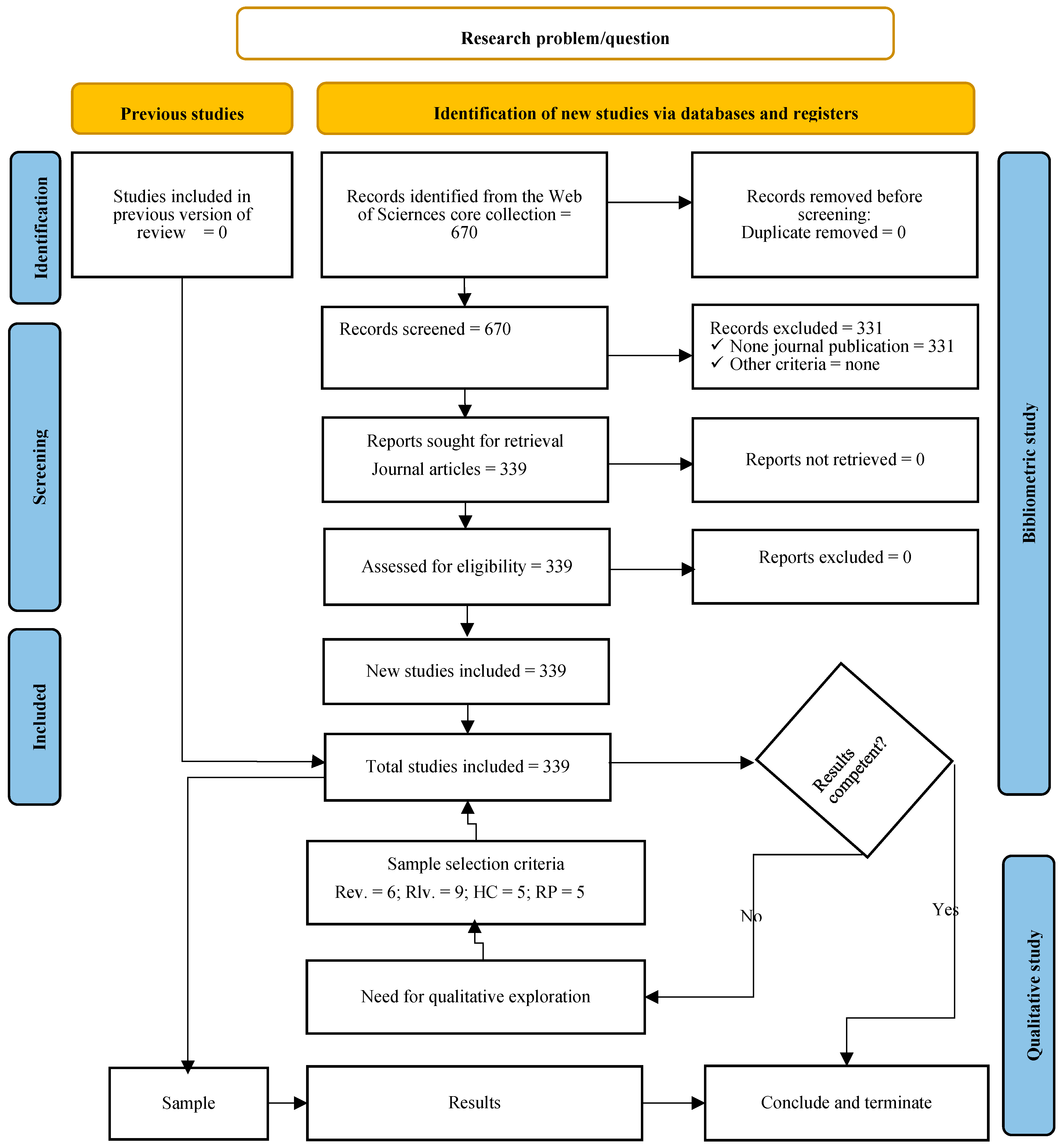
2. Materials and Methods
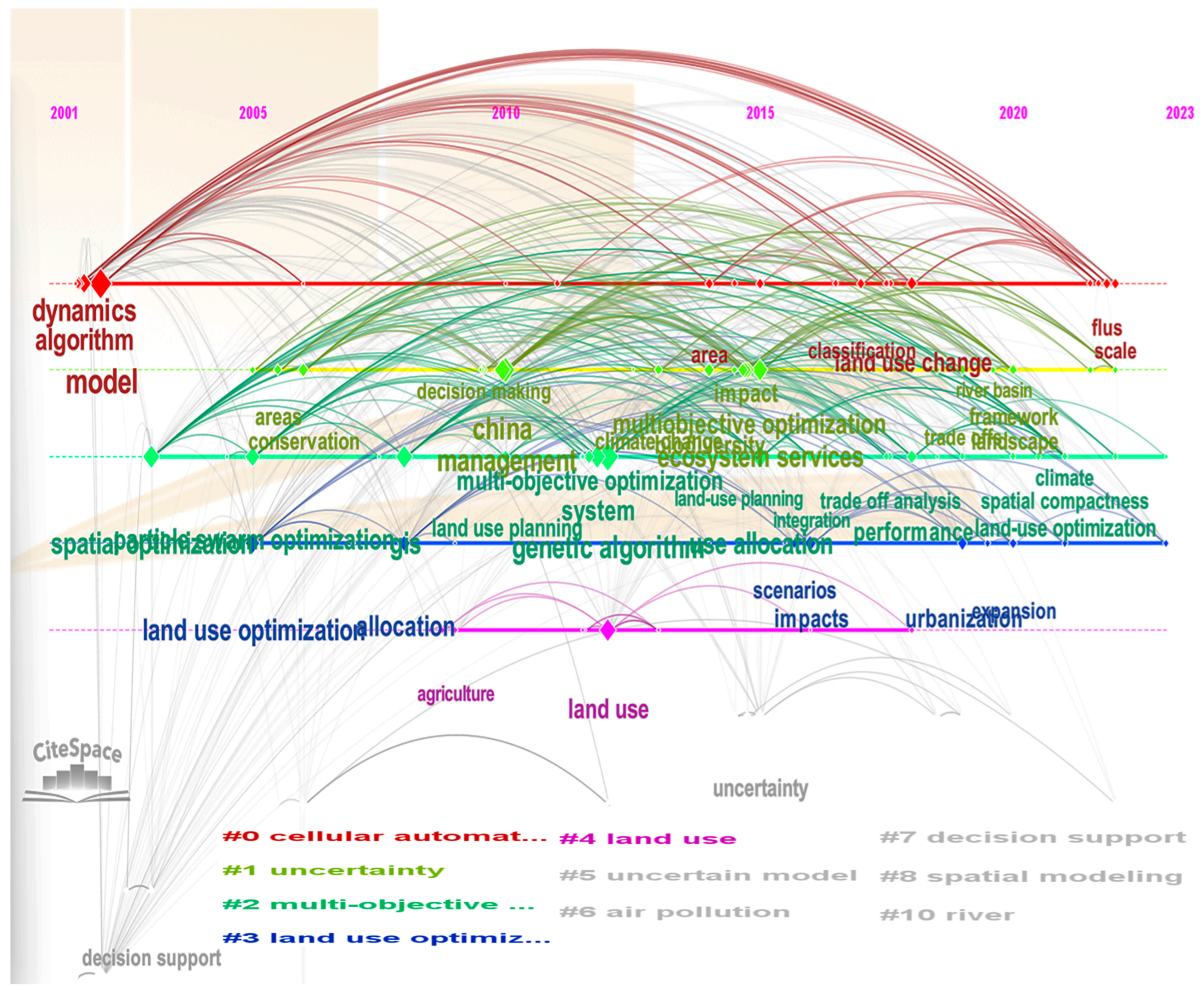
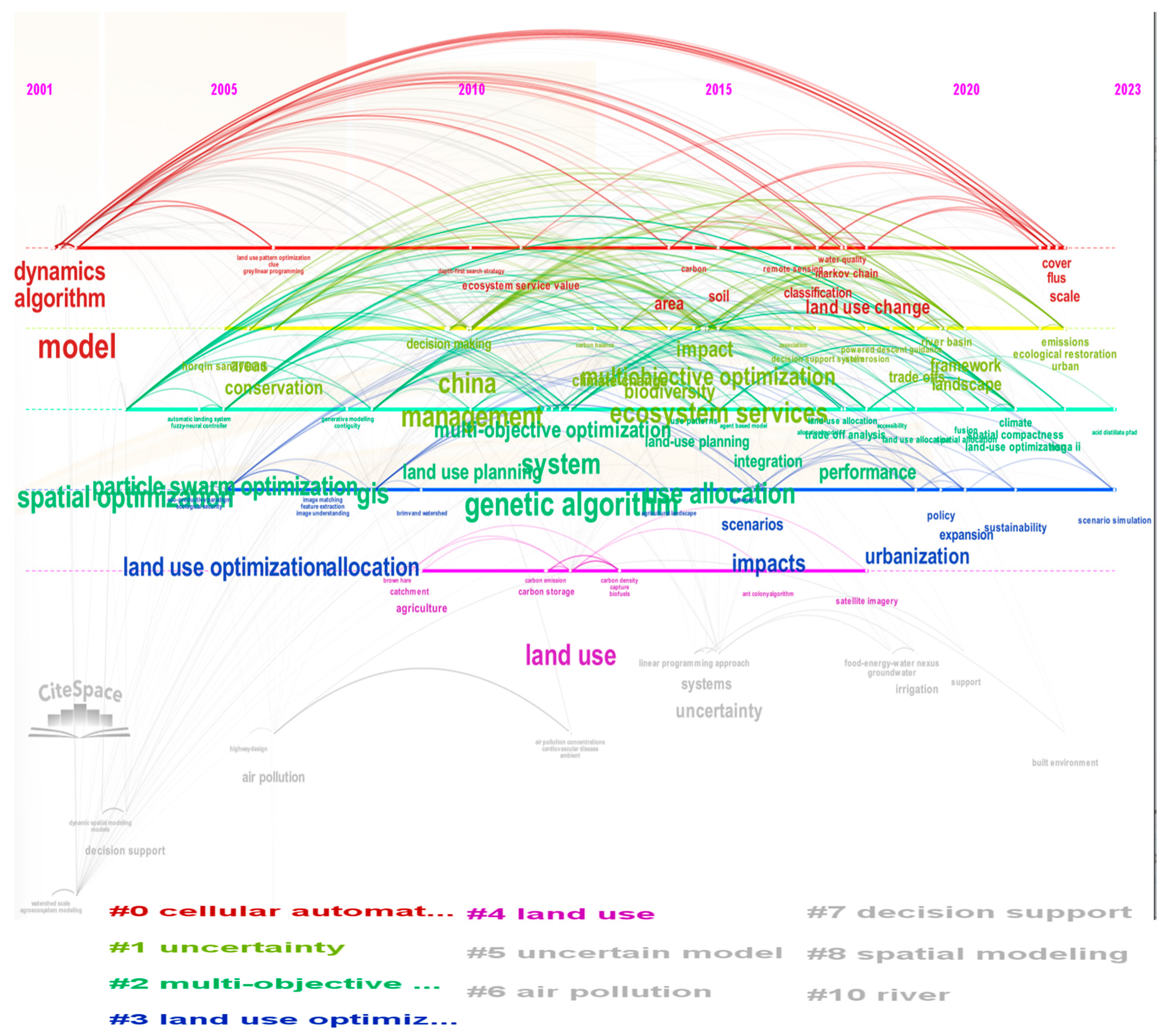
3. Bibliometric Indications
4. Previous Review Works
4.1. Brief Summary of Content Coverage
4.2. Value and Frontiers
5. Review of the Regular Articles
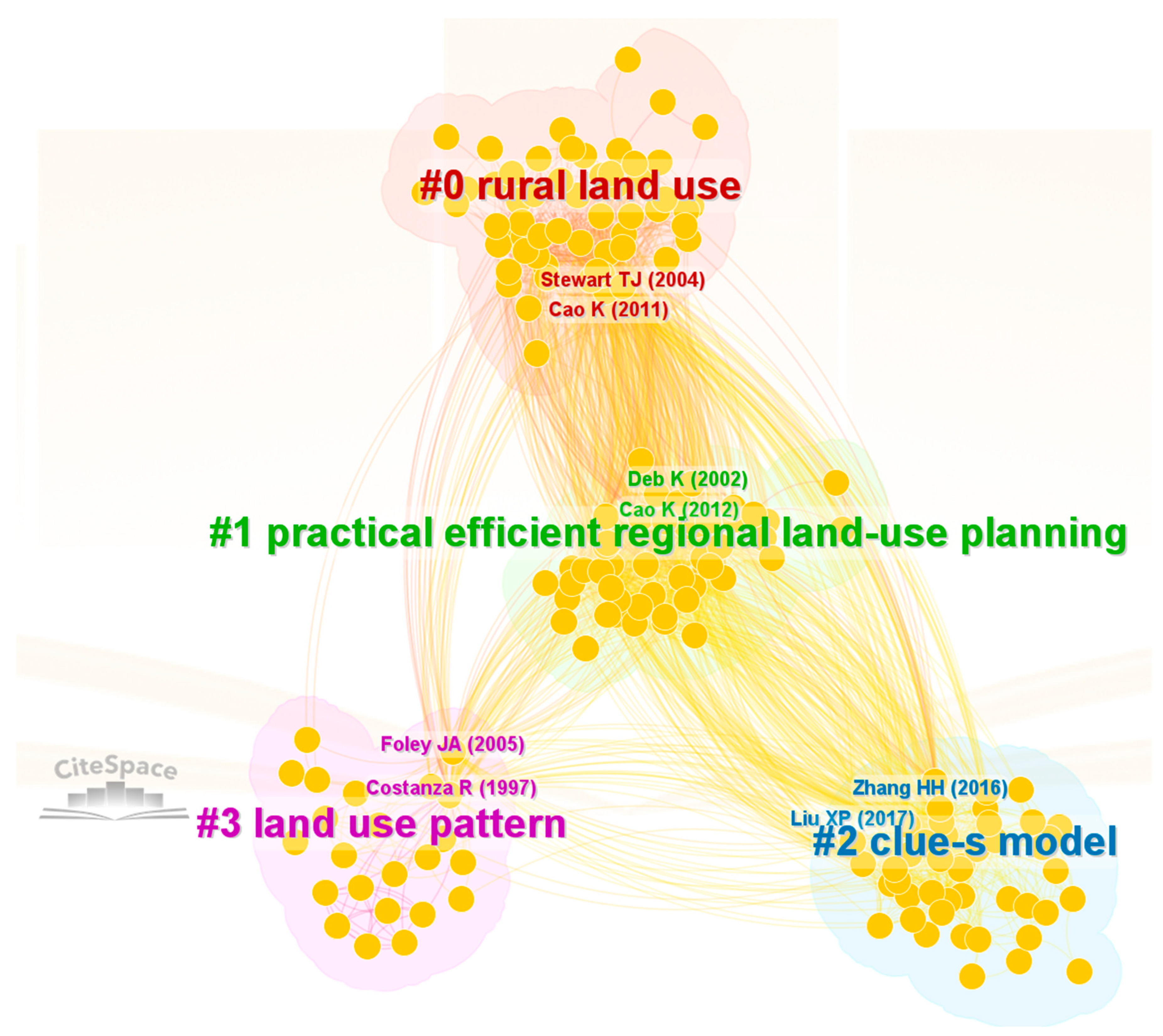
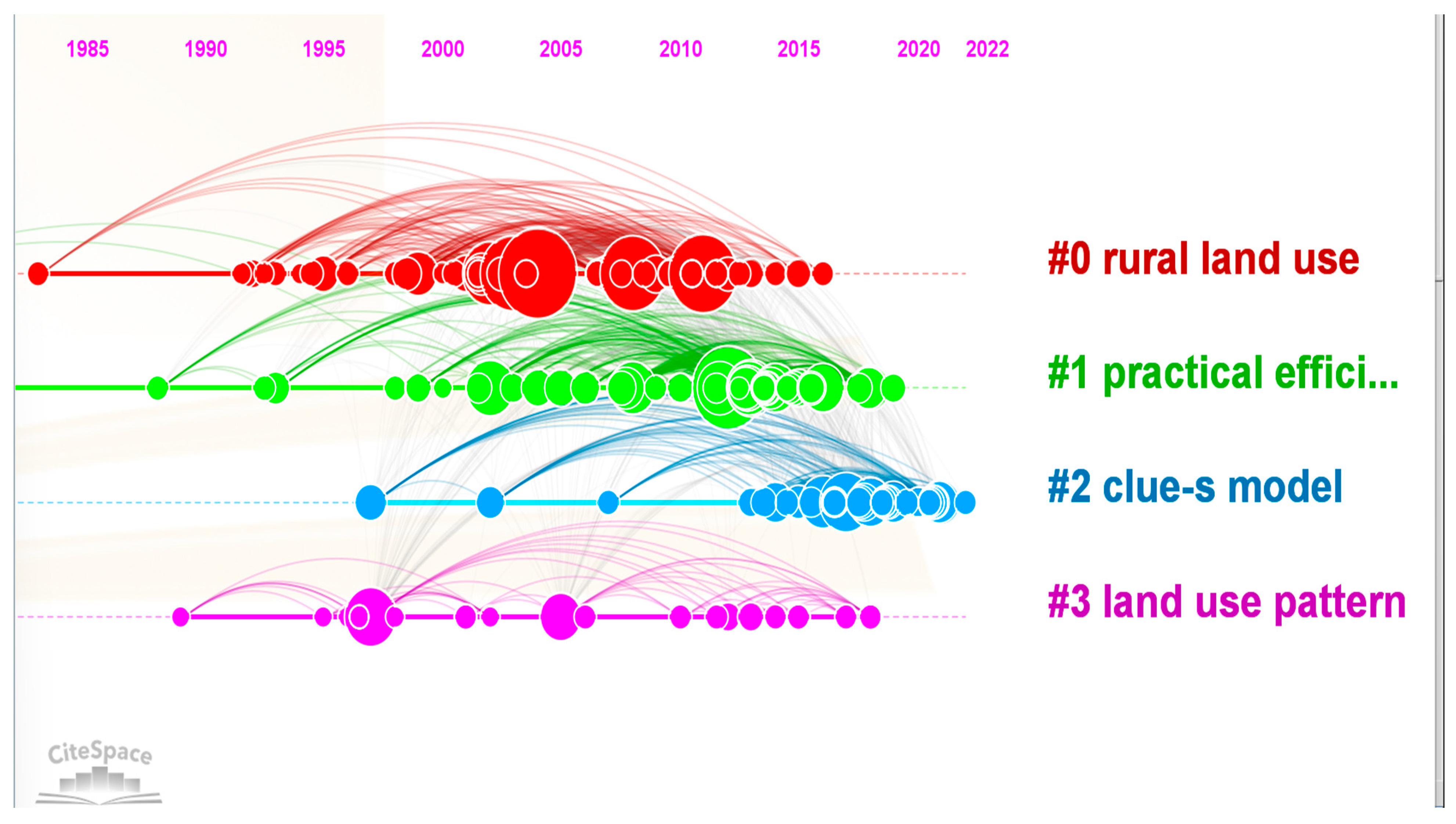
5.1. Literature Path Building
5.2. Land Use Planning Context and Method Development
5.2.1. Land Use Planning Context
Current State
Frontiers
5.2.2. Optimization Methods
Current Status
- (i)
- They questioned whether spatial evaluation and stakeholders’ surveys generate appropriate alternative schemes that shape the effectiveness of planning decisions;
- (ii)
- They highlighted the integration of ESs into land use without optimization technology (See [15]);
- (iii)
- They pointed out the efficiency limitations of manually generated planning schemes, emphasizing that representing government policy restrictions in a model is often challenging.
- (i)
- Servitude companion (SC)—certain functionalities of one global optimizer are mapped into another global optimizer as integral parts.
- (ii)
- Semi-parallel cooperation (SPC)—solutions that are unable to pass one global optimizer are evaluated by another global optimizer, and solutions of both streams are pooled together (and may undergo further local search operation).
- (iii)
- Sequential coupling (SqC)—the output of one (usually the global optimizer) is used as input to the other(s) (usually local optimizers). This is also observed between two local layout simulators.
- (iv)
- Bonded integration of transition rules (BITR)—land use transition rules are drawn based on principles drawn from multiple methods. Any one of the methods that contribute conceptual principles for devising the rule can serve as a hosting agent, while simulating land use transition.
Frontiers
6. Conclusions
Author Contributions
Funding
Data Availability Statement
Conflicts of Interest
Appendix A

Appendix B

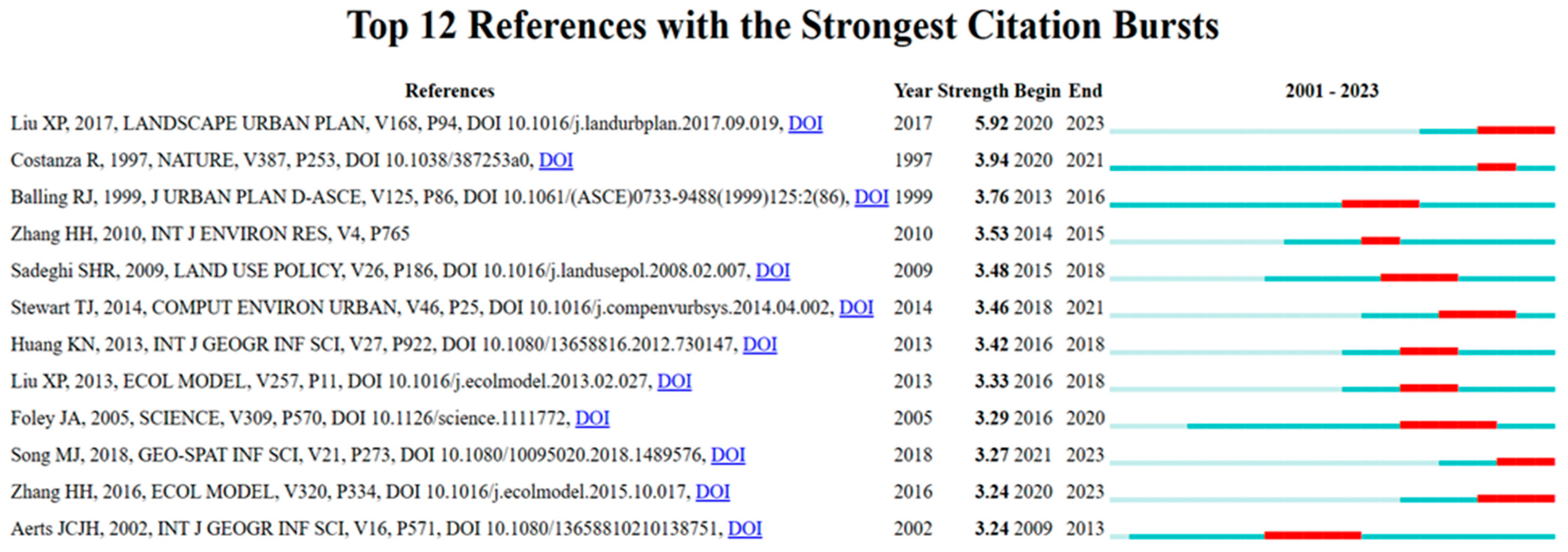
| Cluster ID | Citation Counts | References | DOI |
|---|---|---|---|
| 0 | 49 | Stewart TJ, 2004, COMPUT OPER RES, V31, P2293 [24] | 10.1016/S0305-0548(03)00188-6 |
| 1 | 42 | Cao K, 2012, COMPUT ENVIRON URBAN, V36, P257 [29] | 10.1016/j.compenvurbsys.2011.08.001 |
| 0 | 37 | Cao K, 2011, INT J GEOGR INF SCI, V25, P1949 [25] | 10.1080/13658816.2011.570269 |
| 0 | 34 | Aerts JCJH, 2003, GEOGR ANAL, V35, P148 [28] | 10.1353/geo.2003.0001 |
| 0 | 34 | Ligmann-Zielinska A, 2008, INT J GEOGR INF SCI, V22, P601 [27] | 10.1080/13658810701587495 |
| 0 | 22 | Aerts JCJH, 2002, INT J GEOGR INF SCI, V16, P571 [28] | 10.1080/13658810210138751 |
| 3 | 21 | Costanza R, 1997, NATURE, V387, P253 [32] | 10.1038/387253a0 |
| 2 | 21 | Liu XP, 2017, LANDSCAPE URBAN PLAN, V168, P94 [31] | 10.1016/j.landurbplan.2017.09.019 |
| 1 | 18 | Deb K, 2002, IEEE T EVOLUT COMPUT, V6, P182 [30] | 10.1109/4235.996017 |
| 1 | 17 | Liu XP, 2013, ECOL MODEL, V257, P11 [31] | 10.1016/j.ecolmodel.2013.02.027 |
Appendix C
| Cluster ID | Size | Silhouette | Label (LSI) | Label (LLR) | Label (MI) | Avg. Year |
|---|---|---|---|---|---|---|
| 0 | 58 | 0.74 | land use | rural land use (43.41, 10−4) | land use pattern (1.65) | 2004 |
| 1 | 47 | 0.777 | case study | practical efficient regional land use planning (25.91, 10−4) | using accessibility map (1.85) | 2009 |
| 2 | 44 | 0.849 | case study | clue-s model (56.76, 10−4) | potential area identification (1.39) | 2017 |
| 3 | 23 | 0.963 | land use pattern | land use pattern (75.62, 10−4) | land use pattern evolution (0.41) | 2005 |
| 10 | 4 | 1 | a hierarchical optimization approach to watershed land use planning | watershed land use planning (16.92, 10−4) | case study (0.08) | 1993 |
| 11 | 4 | 0.995 | two-stage land use optimization for a food–energy–water nexus system: a case study in Texas, Edwards region | energy-water nexus system (12.42, 0.001) | case study (0.07) | 2018 |
Appendix D

| Cited Paper | Citing Paper | |||
|---|---|---|---|---|
| Author(s) and DOI | Research Issue | Author(s) | Core Research Content | Cited Content |
| [28] | Application of SA to high dimensional non-linear multi-objective multisite land allocation | [39] | Improved knowledge-informed GA for multi-objective land use allocation | BLI—Heuristic algorithms |
| [29] | Modified NSGA-II | BLI—Sustainable development | ||
| [108] | Probabilistic-based gradient multi-objective land use optimization | BLI—Gradient methods in optimization | ||
| [50] | Validity and accuracy comparison b/n various algorithms in land use allocation (including SA) | CRC—What SA it is and its application | ||
| [49] | Application of particle swarm optimization for multi-objective urban land use optimization | BLI—Heuristic algorithm | ||
| [104] | Application of an improved artificial immune system for multi-objective land use allocation | BLI—Heuristic algorithms | ||
| [109] | Application of hybrid heuristic algorithms to multi-objective land use suitability assessment of the quadratic assignment problem | BLI—Heuristic algorithms | ||
| [110] | Multi-objective optimization model to consider transportation, formulated as mixed-integer programing | BLI—Integer programing | ||
| [80] | Improved artificial bee colony algorithm to solve spatial problems | BLI—Heuristic algorithms | ||
| [97] | Application of GA and game theory to solve land allocation problems | BLI—Heuristic algorithms | ||
| [36] | Simulating optimal multi-objective land use Applying multi-agent system and particle swarm | [111] | Urban growth boundary determination based on a multi-objective land use optimization applying a Pareto-front degradation searching strategy where lands were defined as agents | CRC—Application of agent in land use optimization |
| [112] | Collaborative optimal allocation of urban land to determine the growth boundary of urban agglomeration | BLI— The difficulty of transforming optimal land use structures into spatial layout | ||
| [113] | An agent-based optimization of water allocation (market) wherein farmers were represented as an agricultural agent | CRC—Application of agent in land use optimization | ||
| [114] | Linking agent-based modeling with the territorial life cycle assessment in land use planning | BLI—Complexity of spatial and temporal dynamics of territorial transformation | ||
| [115] | Optimizing deep underground infrastructure layouts based on a multi-agent system where each DUI is represented by an agent | CRC—The SE of multi-agent systems | ||
| [116] | Land use simulation (optimization) using CLUMondo mode | BLI—Complexity of quantifying conflicting interests; Use of fractal dimension; Sensitivity of complex landscape patch boundary to human disturbance | ||
| [117] | Use of gray multi-objective optimization and Patch generating land use simulation in land use optimization (hybrid methods) | BLI—The relationship of land use structure optimization and sustainable development | ||
| [118] | ESs value optimization for different scenarios | BLI—Previous studies on carbon sinks focus the relationship between carbon sinks and land use | ||
| [119] | Optimization of land use using a multi-agent system and multi-objective particle swarm optimization | BLI—Chinese land use planning hierarchies | ||
| [39] | Improved knowledge-informed NSGA-II for multi-objective land use optimization | [49] | Comparison of the performances of multi-objective optimization algorithm, NSGA-II, multi-objective particle swarm optimization, and multi-objective evolutionary algorithm in solving urban land use allocation problems | BLI—Many studies applied multi-objective optimization algorithms at regional level; Type of data model in LU optimization; Scalarization of objectives; CRC—Comparison of GA, PPSO, SA |
| [120] | Improved or multi-objective land use allocation | CRC—Improvement mechanisms to NSGA-II | ||
| [31] | Integration of system dynamics and hybrid PS optimization for solving land use allocation problems | [112] | Collaborative optimal allocation of urban land to determine growth boundary of urban agglomeration | BLI—Planning process involving quantity predication and spatial arrangements |
| [51] | Comparison of multi-objective GA, cuckoo search, and PPSO in agricultural land use optimization | BLI—Extensive application of artificial and swarm intelligence in land use allocation optimization | ||
| [121] | Investigating whether converting types of agricultural land can mitigate soil erosion | CRC—Advantage of PSO over others for land use optimization | ||
| [52] | Coupling Markov and CA to solve the structural–spatial coupled optimization problem | BLI—Wide application of hybrid models to solve land use optimization | ||
| [122] | Use of CA-Markov, land change modeler, patch-generating land use simulation to simulate the LUCC | BLI—Description of quantitative prediction models in land use optimization | ||
| [123] | Study on past and future land use changes in the Qinghai-Tibet Plateau to reflect effects of different policies/scenarios | BLI—Dynamic system is among the main simulation modeling | ||
| [10] | Multi-objective particle swarm optimization algorithm to find the best land use adjustment strategies for village classification | BLI—Land use optimization accounts current situation and multiple objectives | ||
| [13] | Integrating transport into urban land use optimization | BLI—How different studies consider accessibility | ||
| [124] | Modeling land use spatial conflict measurement based on a quantitative analysis of land use changes using ArCGIS 10.8, Yaahp, and SPSSAU 21.0 software | BLI—Advantage of entropy method in weighting objectives | ||
| [105] | A special purpose GIS GA to solve both direct (additive) objectives and indirect (spatial) objective | [125] | Accuracy in the extraction of the drainage network and morphometric analysis for assessing geomorphological characteristics and hydrological processes | BLI—Mentioning works undertaken to study the areas that are vulnerable to flood |
| [126] | Analyzing change in green space in different scenarios and the index characteristics of landscape patterns using FLUUS | BLI—Mentioning the authors optimized the spatial distribution of land resources using handling multiple objectives | ||
| [127] | Evaluating the carbon and GDP reconciliation using a multi-objective particle swarm algorithm | BLI—The authors utilized multi-objective programming | ||
| [128] | Compare performance of synchronous hypervolume-based NSGA-II and a memetic algorithm (MA), in which SH-NSGA-II is enhanced with a local search in amulti-objective Marian spatial planning problem | BLI—The iterative approach in land use optimization | ||
| [129] | High performance GA in land use optimization | BLI—The use of Ga in land use allocation | ||
| [59] | Land use optimization based on ESV | [130] | Adjusted dynamic two-stage optimization to explore comprehensive managerial insights of irrigative areas and forest expansion | BLI—The danger of water and soil erosion for sustainable development |
| [131] | NSGA-II for land use optimization that minimizes runoff and sediment and maximizes economic benefits, occupational opportunities, and land use suitability | BLI—Categorization of land optimization methods | ||
| [132] | Use of multi-objective linear programming and CLUE-S to optimize under different scenarios | BLI—Land use optimization need to address both economic and ecosystem elements | ||
| [133] | Application of MOP and FLUS to optimize land use allocation under strict ecological constraints | BLI—Optimization objectives are specific where the study area is small | ||
| [134] | Allocating land use and land cover (LULC) to minimize the surface for flood mitigation using goal programing and CLUE-S | BLI—Land use optimization is one of the proper solutions for soil and water conservation at the watershed level | ||
References
- Ma, S.; Zhang, Y.; Sun, C. Optimization and Application of Integrated Land Use and Transportation Model in Small-and Medium-Sized Cities in China. Sustainability 2019, 11, 2555. [Google Scholar] [CrossRef]
- Krehl, A.; Siedentop, S.; Taubenböck, H.; Wurm, M. A Comprehensive View on Urban Spatial Structure: Urban Density Patterns of German City Regions. Int. J. Geo-Inf. 2016, 5, 76. Available online: https://api.semanticscholar.org/CorpusID:1366807 (accessed on 9 October 2023). [CrossRef]
- Bertaud, A. The Spatial Organization of Cities: Deliberate Outcome or Unforeseen Consequence? Working Paper No. 2004-01; Institute of Urban and Regional Development University of California at Berkeley: Berkeley, CA, USA, 2004; Available online: https://www.researchgate.net/publication/45131759 (accessed on 15 June 2021).
- Anas, A.; Kim, I. General equilibrium models of polycentric endogenous congestion and job agglomeration. J. Urban Econ. 1996, 40, 232–256. [Google Scholar] [CrossRef]
- Andersson, R.; Samartin, A. A Model for Urban Commuting in a Multicenter City. J. Adv. Transp. 1985, 20, 173–191. [Google Scholar] [CrossRef]
- Jones, C. Land use planning policies and market forces: Utopian aspirations thwarted? Land Use Policy 2014, 38, 573–579. [Google Scholar] [CrossRef]
- Liu, C.; Deng, C.; Li, Z.; Liu, Y.; Wang, S. Optimization of Spatial Pattern of Land Use: Progress, Frontiers, and Prospects. Int. J. Environ. Res. Public Health 2022, 19, 5805. [Google Scholar] [CrossRef]
- Li, C.; Wu, Y.; Gao, B.; Zheng, K.; Wu, Y.; Li, C. Multi-scenario simulation of ecosystem service value for optimization of land use in the Sichuan-Yunnan ecological barrier, China. Ecol. Indic. 2021, 132, 108328. [Google Scholar] [CrossRef]
- Chaturvedi, V.; de Vries, W.T. Machine Learning Algorithms for Urban Land Use Planning: A Review. Urban Sci. 2021, 5, 68. [Google Scholar] [CrossRef]
- Chen, X.; Zhao, R.; Shi, P.; Zhang, L.; Yue, X.; Han, Z.; Wang, J.; Dou, H. Land Use Optimization Embedding in Ecological Suitability in the Embryonic Urban Agglomeration. Land 2023, 12, 1164. [Google Scholar] [CrossRef]
- Mori, T. Monocentric Versus Polycentric Models in Urban Economics; discussion paper series No. 611; Kyoto Institute of Economic Research Kier: Kyoto, Japan, 2006; Available online: http://www.kier.kyoto-u.ac.jp/index.html (accessed on 1 May 2021).
- Broitman, D. Dynamics of Polycentric Urban Structure Dynamics of Polycentric Urban Structure. Ph.D. Thesis, Technion—Israel Institute of Technology, Haifa, Israel, 2012. [Google Scholar]
- Wang, Z.; Han, Q.; De Vries, B. Land Use Spatial Optimization Using Accessibility Maps to Integrate Land Use and Transport in Urban Areas. Appl. Spat. 2022, 15, 1193–1217. [Google Scholar] [CrossRef]
- Liu, Y.; Tang, W.; He, J.; Liu, Y.; Ai, T.; Liu, D. A land use spatial optimization model based on genetic optimi-zation and game theory. Comput. Environ. Urban Syst. 2015, 49, 1–14. [Google Scholar] [CrossRef]
- Wu, X.; Wang, S.; Fu, B.; Liu, Y.; Zhu, Y. Land use optimization based on ecosystem service assessment: A case study in the Yanhe watershed. Land Use Policy 2018, 72, 303–312. [Google Scholar] [CrossRef]
- Jabareen, Y.R. Sustainable urban forms: Their typologies, models, and concepts. J. Plan. Educ. Res. 2006, 26, 38–52. [Google Scholar] [CrossRef]
- Jenks, M.; Burgess, R. (Eds.) Compact Cities: Sustainable Urban Forms for Developing Countries; Spon Press: London, UK; New York, NY, USA, 2000. [Google Scholar]
- Rahman, M.M.; Szabó, G. Multi-objective urban land use optimization using spatial data: A systematic review. Sustain. Cities Soc. 2021, 74, 103214. [Google Scholar] [CrossRef]
- Paré, G.; Trudel, M.C.; Jaana, M.; Kitsiou, S. Synthesizing information systems knowledge: A typology of literature reviews. Inf. Manag. 2015, 52, 183–199. [Google Scholar] [CrossRef]
- Cronin, P.; Ryan, F.; Coughlan, M. Undertaking a literature review: A step-by-step approach. Br. J. Nur. 2008, 17, 38–43. [Google Scholar] [CrossRef]
- Liberati, A.; Altman, D.G.; Tetzlaff, J.; Mulrow, C.; Gøtzsche, P.C.; Ioannidis, J.P.A.; Clarke, M.; Devereaux, P.j.; Kleijnen, J.; Moher, D. The PRISMA statement for reporting systematic reviews and meta-analyses of studies that evaluate health care interventions: Explanation and elaboration. Ann. Intern. Med. 2009, 151, W-65. [Google Scholar] [CrossRef]
- Snyder, H. Literature review as a research methodology: An overview and guidelines. J. Bus. Res. 2019, 104, 333–339. [Google Scholar] [CrossRef]
- Stewart, T.J.; Janssen, R.; van Herwijnen, M. A Genetic Algorithm Approach to Multiobjective Land Use Planning. Comput. Oper. Res. 2004, 31, 2293–2313. [Google Scholar] [CrossRef]
- Moher, D.; Liberati, A.; Tetzlaff, J.; Altman, D.G. Preferred reporting items for systematic reviews and me-ta-analyses: The PRISMA statement. PLoS Med. 2009, 6, e1000097. [Google Scholar] [CrossRef]
- Cao, K.; Batty, M.; Huang, B.; Liu, Y.; Yu, L.; Chen, J. Spatial multi-objective land use optimization: Extensions to the non-dominated sorting genetic algorithm-II. Int. Geogr. Inf. Sci. 2011, 25, 1949–1969. [Google Scholar] [CrossRef]
- Aerts, J.C.J.H.; van Herwijnen, M.; Stewart, T.J. Using Simulated Annealing and Spatial Goal Programming for Solving a Multi Site Land Use Allocation Problem. In Evolutionary Multi-Criterion Optimization: Lecture Notes in Computer Science; Fonseca, C.M., Fleming, P.J., Zitzler, E., Thiele, L., Deb, K., Eds.; Springer: Berlin/Heidelberg, Germany, 2003; Volume 2632, pp. 448–463. [Google Scholar] [CrossRef]
- Ligmann-Zielinska, A.; Church, R.; Jankowski, P. Spatial optimization as a generative technique for sustainable multiobjective land use allocation. Int. Geogr. Inf. Sci. 2008, 22, 601–622. [Google Scholar] [CrossRef]
- Aerts, J.C.J.H.; Heuvelink, G.B.M. Using simulated annealing for resource allocation. Int. Geogr. Inf. Sci. 2002, 16, 571–587. [Google Scholar] [CrossRef]
- Cao, K.; Huang, B.; Wang, S.; Lin, H. Sustainable land use optimization using Boundary-based Fast Genetic Algorithm. Comput. Environ. Urban Sys. 2012, 36, 257–269. [Google Scholar] [CrossRef]
- Deb, K.; Pratap, A.; Agrawal, S.; Meyarivan, T. A fast and elitist multiobjective genetic algorithm: NSGA-II. IEEE Trans. Evol. Comput. 2002, 6, 182–197. [Google Scholar] [CrossRef]
- Liu, X.; Ou, J.; Li, X.; Ai, B. Combining system dynamics and hybrid particle swarm optimization for land use allocation. Ecol. Model 2013, 257, 11–24. [Google Scholar] [CrossRef]
- Costanza, R.; d’Arge, R.; Rudolf, G.; Stephen, F.; Monica, G.; Bruce, H.; Karin, L.; Shahid, N.; O’Neill, R.V.; José, P.; et al. The Value of the World’s Ecosystem Services and Natural Capital. Nature 1997, 387, 253–260. [Google Scholar] [CrossRef]
- Liu, G.; Jin, Q.; Li, J.; Li, L.; He, C.; Huang, Y.; Yao, Y. Policy factors impact analysis based on remote sensing data and the CLUE-S model in the Lijiang River Basin, China. Catena 2017, 158, 286–297. [Google Scholar] [CrossRef]
- Mohammadi, M.; Nastaran, M.; Sahebgharani, A. Development, application, and comparison of hybrid meta-heuristics for urban land-use allocation optimization: Tabu search, genetic, GRASP, and simulated annealing algorithms. Comp. Environ. Urban Sys. 2016, 60, 23–36. [Google Scholar] [CrossRef]
- Pan, T.; Zhang, Y.; Su, F.; Lyne, V.; Cheng, F.; Xiao, H. Practical Efficient Regional Land-Use Planning Using Constrained Multi-Objective Genetic Algorithm Optimization. ISPRS Int. J. Geo-Inf. 2021, 10, 100. [Google Scholar] [CrossRef]
- Zhang, H.; Zeng, Y.; Jin, X.; Shu, B.; Zhou, Y.; Yang, X. Simulating multi objective land use optimization allocation using Multi-agent system-A case study in Changsha, China. Ecol. Model 2016, 320, 334–347. [Google Scholar] [CrossRef]
- Li, X.; Ma, X. An improved simulated annealing algorithm for interactive multi-objective land resource spatial allocation. Ecol. Complex. 2018, 36, 184–195. [Google Scholar] [CrossRef]
- Liu, H.; Yan, F.; Tian, H. Towards low-carbon cities: Patch-based multi-objective optimization of land use allocation using an improved non-dominated sorting genetic algorithm-II. Ecol. Indic. 2022, 34, 108455. [Google Scholar] [CrossRef]
- Song, M.; Chen, D. An improved knowledge-informed NSGA-II for multi-objective land allocation (MOLA). Geo-Spat. Inf. Sci. 2018, 21, 273–287. [Google Scholar] [CrossRef]
- Ding, X.; Zheng, M.; Zheng, X. The application of genetic algorithm in land use optimization research: A review. Land 2021, 10, 526. [Google Scholar] [CrossRef]
- Donthu, N.; Kumar, S.; Mukherjee, D.; Pandey, N.; Lim, W.M. How to conduct a bibliometric analysis: An over-view and guidelines. J. Bus. Res. 2021, 133, 285–296. [Google Scholar] [CrossRef]
- Memmah, M.M.; Lescourret, F.; Yao, X.; Lavigne, C. Metaheuristics for agricultural land use optimization. A review. Agron. Sustain. Dev. 2015, 35, 975–998. [Google Scholar] [CrossRef]
- Kaim, A.; Cord, A.F.; Volk, M. A review of multi-criteria optimization techniques for agricultural land use allocation. Environ. Model. Softw. 2018, 105, 79–93. [Google Scholar] [CrossRef]
- Yao, J.; Zhang, X.; Murray, A.T. Spatial Optimization for land use allocation: Accounting for Sustainability Concerns. Int. Reg. Sci. Rev. 2018, 41, 579–600. [Google Scholar] [CrossRef]
- Xin, Y.; Xin-Qi, Z.; Li-Ln, L. A spatiotemporal model of land use change based on ant colony optimization, Markov chain and cellular automata. Ecol. Model 2012, 233, 11–19. [Google Scholar] [CrossRef]
- Ouyang, Q.; Xu, H.Y. The study of the comparison of three crossover operators in genetic algorithm for solving single machine scheduling problem. In Proceedings of the 6th ICMSE, Qingdao, China, 17–19 July 2015; Atlantis Press: Amsterdam, The Netherlands, 2015; pp. 293–297. [Google Scholar] [CrossRef]
- Magalhaes-Mendes, J. A comparative study of crossover operators for genetic algorithms to solve the job shape scheduling problem. WSEAS Trans. Comput. 2003, 12, 164–173. Available online: https://api.semanticscholar.org/CorpusID:9217369 (accessed on 7 July 2023).
- Misevicius, A.; Kilda, B. Comparison of crossover operators for the quadratic assignment problem. Inf. Technol. Control 2005, 34, 109–119. Available online: https://api.semanticscholar.org/CorpusID:14093494 (accessed on 20 September 2023).
- Masoumi, Z.; van Genderen, J. Artificial intelligence for sustainable development of smart cities and urban land use management. Geo-Spat. Inf. Sci. 2023, 1–25. [Google Scholar] [CrossRef]
- Jahanishakib, F.; Ardakani, T.; Sabaee, M.S.; Salmanmahiny, A. Accuracy and validity assessment of application algorithms in land use allocation into comparison LP, SA, MOLA and MDCHOICE. Geocarto Int. 2022, 37, 10597–10618. [Google Scholar] [CrossRef]
- Sajith, G.; Srinivas, R.; Golberg, A.; Magner, J. Bio-inspired and artificial intelligence enabled hydro-economic model for diversified agricultural management. Agric. Water Manag. 2022, 269, 107638. [Google Scholar] [CrossRef]
- Ou, D.; Zhang, Q.; Tang, H.; Qin, J.; Yu, D.; Deng, O.; Gao, X.; Liu, T. Ecological spatial intensive use optimization modeling with framework of cellular automata for coordinating ecological protection and economic development. Sci. Total Environ. 2023, 857, 159319. [Google Scholar] [CrossRef] [PubMed]
- Yuan, M.; Liu, Y.; He, J.; Liu, D. Regional land use allocation using a coupled MAS and GA model: From local simulation to global optimization, a case study in Caidian District, Wuhan, China. Cartogr. Geogr. Inf. Sci. 2014, 41, 363–378. [Google Scholar] [CrossRef]
- Hasegawa, T.; Fujimori, S.; Ito, A.; Takahashi, K.; Masui, T. Global land use allocation model linked to an integrated assessment model. Sci. Total Environ. 2017, 580, 787–796. [Google Scholar] [CrossRef]
- Verburg, P.H.; Tabeau, A.; Hatna, E. Assessing spatial uncertainties of land allocation using a scenario approach and sensitivity analysis: A study for land use in Europe. J. Environ. Manag. 2013, 127, S132–S144. [Google Scholar] [CrossRef]
- Chakir, R.; Le Gallo, J. Predicting land use allocation in France: A spatial panel data analysis. Ecol. Econ. 2013, 92, 114–125. [Google Scholar] [CrossRef]
- Seppelt, R.; Voinov, A. Optimization methodology for land use patterns using spatially explicit landscape models. Ecol. Model. 2002, 151, 125–142. [Google Scholar] [CrossRef]
- Jin, N.; Termansen, M.; Hubacek, K. Genetic Algorithms for dynamic land-use optimization. In Proceedings of the IEEE Congress on Evolutionary Computation (IEEE World Congress on Computational Intelligence), Hong Kong, China, 1–6 June 2008; pp. 3816–3821. [Google Scholar] [CrossRef]
- Sadeghi, S.H.R.; Jalili, K.; Nikkami, D. Land use optimization in watershed scale. Land Use Policy 2009, 26, 186–193. [Google Scholar] [CrossRef]
- Cheng, S.; Chan, C.W.; Huang, G.H. An integrated multi-criteria decision analysis and inexact mixed integer linear programming approach for solid waste management. Artif. Intell. Eng. 2003, 16, 543–554. [Google Scholar] [CrossRef]
- Dong, C.; Huang, G.H.; Tan, Q.; Cai, Y. Coupled planning of water resources and agricultural landuse based on an inexact-stochastic programming model. Front. Earth Sci. 2014, 8, 70–80. [Google Scholar] [CrossRef]
- Zhou, M.; Cai, Y.; Guan, X.; Tan, S.; Lu, S. A hybrid inexact optimization model for land use allocation of China. Chin. Geogr. Sci. 2015, 25, 62–73. [Google Scholar] [CrossRef]
- Liu, Y.; Yu, Y.; Guo, H.; Yang, P. Optimal land use management for surface source water protection under uncer-tainty: A case study of Songhuaba watershed (Southwestern China). Water Resour. Manag. 2009, 23, 2069–2083. [Google Scholar] [CrossRef]
- Li, X.; Ma, X. An uncertain programming model for land use structure optimization to promote effectiveness of land use planning. Chin. Geogr. Sci. 2017, 27, 974–988. [Google Scholar] [CrossRef]
- Zhu, W.; Gao, Y.; Zhang, H.; Liu, L. Science of the Total Environment Optimization of the land use pattern in Horqin Sandy Land by using the CLUMondo model and Bayesian belief network. Sci. Total Environ. 2020, 739, 139929. [Google Scholar] [CrossRef]
- Jin, X.; Jiang, P.; Ma, D.; Li, M. Land system evolution of Qinghai-Tibetan Plateau under various development strategies. Appl. Geogr. 2019, 104, 1–9. [Google Scholar] [CrossRef]
- Li, G.; Zhao, Z.; Wang, L.; Li, Y.; Li, Y. Optimization of Ecological Land Use Layout Based on Multimodel Coupling. J. Urban Plan. Dev. 2023, 149, 04022053. [Google Scholar] [CrossRef]
- Li, X.; Xu, H.; Ma, X.; Huang, Y. A two-step spatially explicit optimization approach of integrating ecosystem services (ES) into land use planning (LUP) to generate the optimally sustainable schemes. Land Degrad. Dev. 2023, 34, 2508–2522. [Google Scholar] [CrossRef]
- Randolph, J. Environmental Land Use Planning and Management; Island Press: Washington, DC, USA, 2004. [Google Scholar]
- Handayanto, R.T.; Tripathi, N.K.; Kim, S.M.; Guha, S. Achieving a sustainable urban form through land use optimisation: Insights from Bekasi City’s land use plan (2010–2030). Sustainability 2017, 9, 221. [Google Scholar] [CrossRef]
- Chuvieco, E. Integration of linear programming and GIS for land use modelling. Int. J. Geogr. Inf. Sci. 1993, 7, 71–83. [Google Scholar] [CrossRef]
- Janssen, R.; van Herwijnen, M.; Stewart, T.; Aerts, J.C.J.H. Multiobjective decision support for landuse planning. Environ. Plan B 2008, 35, 740–756. [Google Scholar] [CrossRef]
- Rodrigue, J. The Utility Value of Land Use: Theoretical Foundations and Application to Shanghai. J. Transp. Geogr. 1994, 2, 441–454. [Google Scholar] [CrossRef]
- Anas, A.; Arnott, R.; Small, K.A. Urban Spatial Structure; Transport Center; Working paper No. 357; The University of California: Los Angeles, CA, USA, 1997; Available online: https://www.researchgate.net/publication/4981416_Urba (accessed on 25 August 2023).
- Allen, P.M.; Sanglier, M. A dynamic model of central place system—II. Geogr. Ann. 1981, 13, 149–164. [Google Scholar] [CrossRef]
- Allen, P.M.; Sanglier, M. Urban evolution, self-organization, and decision making. Environ. Plan. 1981, 13, 167–183. [Google Scholar] [CrossRef]
- Boussauw, K.; Witlox, F. Introducing a commute-energy performance index for Flanders. Transp. Res. A 2009, 43, 580–591. [Google Scholar] [CrossRef]
- Guth, D.; Holz-Rau, C.; Maciolek, M. Employment suburbanisation and commuter traffic in German city regions. In Proceedings of the 9th Swiss Transport Research Conference, Monte Verita, Switzerland, 9–11 September 2009; pp. 1–22. Available online: https://api.semanticscholar.org/CorpusID:130110269 (accessed on 12 April 2021).
- Ewing, R. Is Los Angeles Style Sprawl Desirable? J. Am. Plan 1997, 63, 108–126. [Google Scholar] [CrossRef]
- Yang, Z.; Zhu, X.; Moodie, D.R. Optimization of Land Use in a New Urban District. J. Urban Plan. Dev. 2015, 141, 05014010. [Google Scholar] [CrossRef]
- Ashenafi, A. Optimization Based Approach for Landuse/Transportation Policy Making. Ph.D Thesis, University of Coimbra, Coimbra, Portugal, 2015. Available online: https://hdl.handle.net/10316/28802 (accessed on 5 September 2023).
- Alexander, C. A City Is Not a Tree. In The City Reader, 1st ed.; Routledge: New York, NY, USA, 1992; pp. 118–131. [Google Scholar]
- Mohammadyari, F.; Tavakoli, M.; Zarandian, A.; Abdollahi, S. Optimization land use based on multi-scenario simulation of ecosystem service for sustainable landscape planning in a mixed urban—Forest watershed. Ecol. Model. 2023, 483, 110440. [Google Scholar] [CrossRef]
- Verburg, P.H.; Soepboer, W.; Veldkamp, A.; Limpiada, R.; Espaldon, V. Modeling the spatial dynamics of regional land use: The CLUE-S model. Environ. Manag. 2002, 30, 391–405. [Google Scholar] [CrossRef]
- St. John, R.; Tóth, S.F. Spatially explicit forest harvest scheduling with difference equations. Ann. Oper. Res. 2015, 232, 235–257. [Google Scholar] [CrossRef]
- Sharmin, T. A comparative study of sustainable urban forms: Compact city and short cycle strategy. AIUB J. Sci. Eng. 2011, 10, 1–9. Available online: https://www.researchgate.net/publication/313515348 (accessed on 12 April 2021).
- Mehari, A.; Genovese, P. Modeling Global and Local Aspects of Spatial Structure Explicitly in land use Optimization: The Case of Mek’ele City, Ethiopia. Chin. J. Urban Environ. Stud. 2023, 11, 2350011. [Google Scholar] [CrossRef]
- Kenworthy, J.; Fansler, D.; Newman, P. Cities and Automobile Dependence: An International Sourcebook; Gower: Aldershot, UK, 1989. [Google Scholar]
- Simmonds, D.; Coombe, D. The Transport Implication of Alternative Urban Form. In Achieving Sustainable Urban Form 2; Taylor Francis: London, UK, 2000; pp. 121–130. [Google Scholar]
- Masnavi, M.R. The New Millennium and the New Urban Paradigm: The Compact City in Practice. In Achieving Sustainable Urban Form; Taylor Francis: London, UK, 2000; pp. 64–73. [Google Scholar]
- Stead, D.; Williams, J.; Tifheridge, H. Land Use, Transport and People: Identifying the Connections. In Achieving Sustainable Urban Form; Taylor Francis: London, UK, 2000; pp. 174–186. [Google Scholar]
- Reid, E.; Greenwald, M.; Zhangm, M.; Walters, J.; Feldman, M.; Cervero, R.; Frank, L.; Thomas, J. Traffic generated by mixed-use developments—Six-region study using consistent built environmental measures. J. Urban Plan. Dev. 2011, 137, 248–261. [Google Scholar] [CrossRef]
- De Lara, M.; De Palma, A.; Kilani, M.; Piperno, S. Congestion pricing and long term urban form: Application to Paris region. Reg. Sci. Urban Econ. 2013, 43, 282–295. [Google Scholar] [CrossRef]
- Burton, E. The Potential of the Compact City for Promoting Social Equity. In Achieving Sustainable Urban Form; Taylor Francis: London, UK, 2000; pp. 19–29. [Google Scholar]
- Al-Thani, S.K.; Amato, A.; Kok, M.; Al-Ghamid, S.G. Urban sustainability and livability: An analysis of Doha’s urban-form and possible mitigation strategies. Sustainability 2019, 11, 786. [Google Scholar] [CrossRef]
- Anthony, A.F.; Offia, I.E.; Abidemi, B.R.; Kamoru, O.K.G. Urban Sustainability Concepts and Their Implications on Urban Form. Urban Reg. Plan. 2018, 3, 27–33. [Google Scholar] [CrossRef]
- Paritosh, P.; Kalita, B.; Sharma, D. A game theory based land layout optimization of cities using genetic algorithm. Int. J. Manag. Sci. 2019, 14, 155–168. [Google Scholar] [CrossRef]
- Zhang, H.H.; Zeng, Y.N.; Bian, L. Simulating multi-objective spatial optimization allocation of land use based on the integration of multi-agent system and genetic algorithm. Int. J. Environ. Res. 2010, 4, 765–776. [Google Scholar]
- Chieng, H.; Wahid, N. A performance comparison of genetic algorithm’s mutation operators in n-cities open loop travel salesman problem. Recent Adv. Soft Comput. Data Min. 2014, 287, 89–97. [Google Scholar] [CrossRef]
- Otman, A.; Jaafar, A. A comparative study of adaptive crossover for GA to resolve the travel salesman problem. Int. J. Comput. Appl. 2014, 31, 49–57. [Google Scholar]
- Kumar, S.G.; Panneerselevam, R. A study of crossover operators for genetic algorithm to solve VRP and its variants and new Sinusoidal Motion crossover operator. Int. J. Comput. Intell. Res. 2017, 1367, 1717–1735. Available online: https://api.semanticscholar.org/CorpusID:195181207 (accessed on 3 August 2023).
- Hakimi, D.; Oyewola, D.O.; Yahaya, Y.; Bolarin, G. Comparative analysis of genetic crossover operators in Knapsack problem. J. Appl. Environ. Manag. 2014, 20, 593–596. Available online: https://api.semanticscholar.org/CorpusID:125900969 (accessed on 3 August 2023). [CrossRef]
- Alajmi, A.; Wright, J. Selecting the most efficient genetic algorithm sets in solving unconstrained building optimization problem. Int. J. Sustain. Built Environ. 2014, 3, 18–26. [Google Scholar] [CrossRef]
- Huang, K.; Liu, X.; Li, X.; Liang, J.; He, S. An improved artificial immune system for seeking the Pareto front of land-use allocation problem in large areas. Int. Geogr. Inf. Sci. 2013, 27, 922–946. [Google Scholar] [CrossRef]
- Stewart, T.J.; Janssen, R. A multiobjective GIS-based land use planning algorithm. Comput. Environ. Urban Sys. 2014, 46, 25–34. [Google Scholar] [CrossRef]
- Balling, R.J.; Taber, J.T.; Brown, M.R.; Day, K. Multiiobjective urban planning using genetic algorithm. J. Urban Plan. Dev. 1999, 125. [Google Scholar] [CrossRef]
- Foley, J.; DeFries, R.; Asner, G.P.; Barford, C.; Bonan, G.; Carpenter, R.R.; Chapin, S.; Coe, M.T.; Daily, G.C.; Gibbs, H.K.; et al. Global Consequences of Land Use. Science 2005, 30, 1111772. [Google Scholar] [CrossRef]
- Luo, H.; Huang, B. A probabilistic framework with the gradient-based method for multi-objective land use optimization. Int. J. Geogr. Inf. Sci. 2023, 37, 1128–1156. [Google Scholar] [CrossRef]
- Khalili-Damghani, K.; Aminzadeh-Goharrizi, B.; Rastegar, S.; Aminzadeh-Goharrizi, B. Solving land-use suitability analysis and planning problem by a hybrid meta-heuristic algorithm. Int. Geogr. Inf. Sci. 2014, 28, 2390–2416. [Google Scholar] [CrossRef]
- Taromi, R.; DuRoss, M.; Chen, B.; Faghri, A.; Li, M.; DeLiberty, T. A multiobjective land development optimization model: The case of New Castle County, Delaware. Transp. Plan. Technol. 2015, 38, 277–304. [Google Scholar] [CrossRef]
- Ma, S.; Cai, Y.; Ai, B.; Xie, D.; Zhao, Y. Delimiting the urban growth boundary for sustainable development with a pareto front degradation searching strategy based optimization model. J. Clean. Prodc. 2022, 345, 131191. [Google Scholar] [CrossRef]
- Ma, S.; Cai, Y.; Xie, D.; Zhang, X.; Zhao, Y. Towards balanced development stage: Regulating the spatial pattern of agglomeration with collaborative optimal allocation of urban land. Cities 2022, 126, 103645. [Google Scholar] [CrossRef]
- Nouri, A.; Saghafian, B.; Bazargan-Lari, M.R.; Delavar, M. Local water market development based on multi-agent based simulation approach Author links open overlay panel. Ground Water Sustain. Dev. 2022, 19, 100826. [Google Scholar] [CrossRef]
- Ding, T.; Achten, W.M.J. Coupling agent-based modeling with territorial LCA to support agricultural land-use planning. J. Clean. Prodc. 2022, 380, 134914. [Google Scholar] [CrossRef]
- Zhang, C.; Zhao, Z.; Guo, D.; Gong, D.; Chen, Y. Optimization of spatial layouts for deep underground infrastructure in central business districts based on a multi-agent system model. Tunnel. Underground Space Technol. 2023, 135, 105046. [Google Scholar] [CrossRef]
- Fan, X.; Cheng, Y.; Li, Y. Multi-Scenario Land Use Simulation and Land Use Conflict Assessment Based on the CLUMondo Model: A Case Study of Liyang, China. Land 2023, 12, 917. [Google Scholar] [CrossRef]
- Meng, F.; Zhou, Z.; Zhang, P. Multi-Objective Optimization of Land Use in the Beijing–Tianjin–Hebei Region of China Based on the GMOP-PLUS Coupling Model. Sustainability 2023, 15, 3977. [Google Scholar] [CrossRef]
- Qin, M.; Zhao, Y.; Liu, Y.; Jiang, H.; Li, H.; Zhu, Z. Multi-scenario Simulation for 2060 and Driving Factors of the Eco-spatial Carbon Sink in the Beibu Gulf Urban Agglomeration, China. Chin. Geogr. Sci. 2023, 33, 85–101. [Google Scholar] [CrossRef]
- Liu, J.; Xia, M. Influencing Factors Analysis and Optimization of Land Use Allocation: Combining MAS with MOPSO Procedure. Sustainability 2023, 15, 1401. [Google Scholar] [CrossRef]
- Niyomubyeyi, O.; Veysipanah, M.; Sarwat, M.; Pilesjö, P.; Mansourian, A. An improved non-dominated sorting biogeography-based optimization algorithm for multi-objective land-use allocation: A case study in Kigali-Rwanda. Geo-Spat. Inf. Sci. 2022. [Google Scholar] [CrossRef]
- Wei, C.; Dong, X.; Yu, D.; Liu, J.; Reta, G.; Kuriqi, A. An alternative to the Grain for Green Program for soil and water conservation in the upper Huaihe River basin, China. J. Hydro. Reg. Stud. 2022, 43, 101180. [Google Scholar] [CrossRef]
- Yu, X.; Xiao, J.; Huang, K.; Li, Y.; Lin, Y.; Qi, G.; Liu, T.; Ren, P. Simulation of Land Use Based on Multiple Models in the Western Sichuan Plateau. Remote Sens. 2023, 15, 3629. [Google Scholar] [CrossRef]
- Xu, R.; Shi, P.; Gao, M.; Wang, Y.; Wang, G.; Su, B.; Huang, J.; Lin, Q.; Jiang, T. Projected land use changes in the Qinghai-Tibet Plateau at the carbon peak and carbon neutrality targets. Sci. China Earth Sci. 2023, 66, 1383–1398. [Google Scholar] [CrossRef]
- Cao, Y.; Jiang, Y.; Feng, L.; Shi, G.; He, H.; Yang, J. Identification of Territorial Spatial Pattern Conflicts in Aksu River Basin, China, from 1990 to 2020. Sustainability 2022, 14, 14941. [Google Scholar] [CrossRef]
- Erosemiah, D.; Viji, R. Study on Drainage Network Pattern and Morphometric Analysis by Using Hydrology Support Algorithm. J. Geol. Soc. India 2023, 99, 1006–1014. [Google Scholar] [CrossRef]
- Li, X.; Li, W.; Gao, Y. Multi-Scenario Simulation of Green Space Landscape Pattern in Harbin City Based on FLUS Model. Int. J. Environ. Res. Public Health 2023, 20, 4286. [Google Scholar] [CrossRef]
- Li, W.; Chen, Z.; Li, M.; Zhang, H.; Li, M.; Qiu, X.; Zho, C. Carbon emission and economic development trade-offs for optimizing land-use allocation in the Yangtze River Delta, China. Ecol. Indic. 2023, 147, 109950. [Google Scholar] [CrossRef]
- Basirati, M.; Billot, R.; Meyer, P. Two parameter-tuned multi-objective evolutionary-based algorithms for zoning management in marine spatial planning. Ann. Math. Artif. Intell. 2023. [Google Scholar] [CrossRef]
- Teijeiro, D.; Amor, M.; Doallo, R.; Corbelle, E.; Porta, J.; Parapar, J. Land consolidation through parcel exchange among landowners using a distributed Spark-based genetic algorithm. J. Supercomput. 2022, 78, 19522–19544. [Google Scholar] [CrossRef]
- Chen, R.; Xu, Z. A two-stage robust optimization framework for land-water-environment nexus management. IOP Conf. Ser. Earth Environ. Sci. 2021, 687, 012042. [Google Scholar] [CrossRef]
- Sheikh, V.; Salmani, H.; Mahiny, A.S.; Ownegh, M.; Fathabadi, A. Land use optimization through bridging multiobjective optimization and multicriteria decision-making models (case study: Tilabad Watershed, Golestan Province, Iran). Nat. Resour. Model. 2021, 34, 12301. [Google Scholar] [CrossRef]
- Jiang, H.; Xu, X.; Wang, L.; Zhang, T. Integrating Ecosystem Service Values and Economic Benefits for Sustainable Land Use Management in Semi-Arid Regions in Northern China. Sustainability 2021, 13, 10431. [Google Scholar] [CrossRef]
- Zhang, H.; Yang, Q.; Zhang, H.; Zhou, L.; Chen, H. Optimization of Land Use Based on the Source and Sink Landscape of Ecosystem Services: A Case Study of Fengdu County in the Three Gorges Reservoir Area, China. Land 2021, 10, 1242. [Google Scholar] [CrossRef]
- Phinyoyang, A.; Ongsomwang, S. Optimizing Land Use and Land Cover Allocation for Flood Mitigation Using Land Use Change and Hydrological Models with Goal Programming, Chaiyaphum, Thailand. Land 2021, 10, 1317. [Google Scholar] [CrossRef]
| Ref. Time | Identified Gap | Suggested Direction/Implications |
|---|---|---|
| 2002 | Optimization methods are problem-dependent. No generalized behavior was established | Improve the efficiency of algorithms through comparison of multiple scenarios |
| 2008 | Mismatch between optimization methods and planning perspective. i.e., assumption of the determined time | Intertemporal approach |
| Global optimization-implemented objectives used at the general management level(this problem still persists in urban land use) | Detailing objectives to a level at which quantifying value resources is practically possible | |
| 2015 | Coupling was not mature enough | Broadening the application and undertaking more research on hybridization approach |
| Limitations of local scale optimizers (game theory) applied independently | Hybridizing local optimizers with global optimizers to take relative advantage of exploration and exploitation | |
| 2017 | Determinate assumption of constraints | Modeling uncertainty |
| 2018 | Any trade-off considered acceptable/a feasible alternative | Minimizing the magnitude of trade-offs among objectives is a quality advantage |
| 2020 | Land use change driving factors not considered | Building the probability of land use change factors into simulations |
| 2021 | Global optimizers lack layout capability, while local optimizers lack structure capability | Coupling top-down and bottom-up methods attained a normative stage of application |
| 2023 | Spatial layout determined by local optimizers is affected by the historical trends of the land use change process | Spatial suitability analysis/horizontal process |
| The heterogeneous nature of spatial units providing ESs is affected by the historical transition record matrix of the logical transition rule | An emerging issue open for inquiry |
| Ref. | Domain | Applied on | Core content | Objectives | Method |
|---|---|---|---|---|---|
| [8] | Planning concept | Large region | Effect of land use change on ES | Economic benefits Max. ESV | GMOP and PLUS |
| [10] | Method | Urban agglomeration | Embedding land use optimization in ecological suitability | ESVs land use suitability | MOLP; DyCLUE; MCR |
| [13] | Planning concept | City | Accessibility model in land use planning | Max. Accessibility; Max. Compactness; Max. Suitability | NSGA-II |
| [14] | Method | Urban and rural region | Coordination of land uses at local level | Max. Suitability of land for a certain use and Max. Compactness | GA; DyGT |
| [15] | Planning concept | Watershed | Effect of land use change on ES | Max. Agricultural production; Max. Sediment retention; Max. Carbon sequestration; Max. Water quality; Max. sustainability of water production | InVEST; Biophysical models |
| [27] | Planning concept | City | Compact form of the sustainable city concept in land use planning | Min. Open space development; Min. Redevelopment; Min. Distance of new development site; Max. compatibility | GIS-MOLA |
| [29] | Method | City | Efficiency of NSGA-II for implementation | Max. GDP; Max. Environmental benefit; Max. Ecological suitability; Max. Accessibility; Max. Compactness; Max. Compatibility; Min. Use conversion; Max. NIMBY | NSGA-II |
| [45] | Method | District of a city | Hybrid optimization method for modeling land use change | NA | Markov-CA; ACO-CA |
| [57] | Method | Watershed | ES-based optimization under different land use management scenarios | Min. fertilizer use, Min. nutrient outflow and Max. economic yield | Monte Carlo; GA |
| [58] | Planning concept | Management farming | Temporal dimension of land use planning | Max. income | GA |
| [59] | Planning concept | Watershed | ES-based optimization | Min. soil erosion and Max. Economic benefit | Simplex-LP |
| [64] | Planning concept | City | Uncertainty incorporation in land use planning | Max. GDP Ecological benefit (ESV) | GA |
| [65] | Planning concept | Large region | Land use change driving factors; Probability surface-based land use optimization | Priority of land use type i | CLUMondo, BBN |
| [66,67] | Method | Large (rural + cities) | Application of hybrid methods for land use optimization | ESVs | DyMOO; CLUE-S; MCR |
| [69] | Planning concept | City region | Method of integrating ecological benefits into land use planning | ESVs Land use suitability | MOOLP CLUE-S |
| [70] | Method | City | Zoning mechanism in land use planning | Max. Compactness; Max. Compactness; Max. Dependency; Max. suitability | PSO; GA; Local search |
| [80] | Planning concept | City | Residential choice model in land use planning | Max. Quality of life for workers and Max. Productivity of facilities | GA |
| [83] | Method | Urban region | Application of hybrid methods for land use optimization | Max. Farm production; Max. Water yield; Max. Habitat quality; Max. Sediment retention; Max. Recreational quality; Max. Aesthetic quality | SA-GA |
Disclaimer/Publisher’s Note: The statements, opinions and data contained in all publications are solely those of the individual author(s) and contributor(s) and not of MDPI and/or the editor(s). MDPI and/or the editor(s) disclaim responsibility for any injury to people or property resulting from any ideas, methods, instructions or products referred to in the content. |
© 2023 by the authors. Licensee MDPI, Basel, Switzerland. This article is an open access article distributed under the terms and conditions of the Creative Commons Attribution (CC BY) license (https://creativecommons.org/licenses/by/4.0/).
Share and Cite
Mehari, A.; Genovese, P.V. A Land Use Planning Literature Review: Literature Path, Planning Contexts, Optimization Methods, and Bibliometric Methods. Land 2023, 12, 1982. https://doi.org/10.3390/land12111982
Mehari A, Genovese PV. A Land Use Planning Literature Review: Literature Path, Planning Contexts, Optimization Methods, and Bibliometric Methods. Land. 2023; 12(11):1982. https://doi.org/10.3390/land12111982
Chicago/Turabian StyleMehari, Ashenafi, and Paolo Vincenzo Genovese. 2023. "A Land Use Planning Literature Review: Literature Path, Planning Contexts, Optimization Methods, and Bibliometric Methods" Land 12, no. 11: 1982. https://doi.org/10.3390/land12111982