
Ecological Change and Livestock Governance in a Peruvian National Park
 , , , ,
Abstract
:1. Introduction
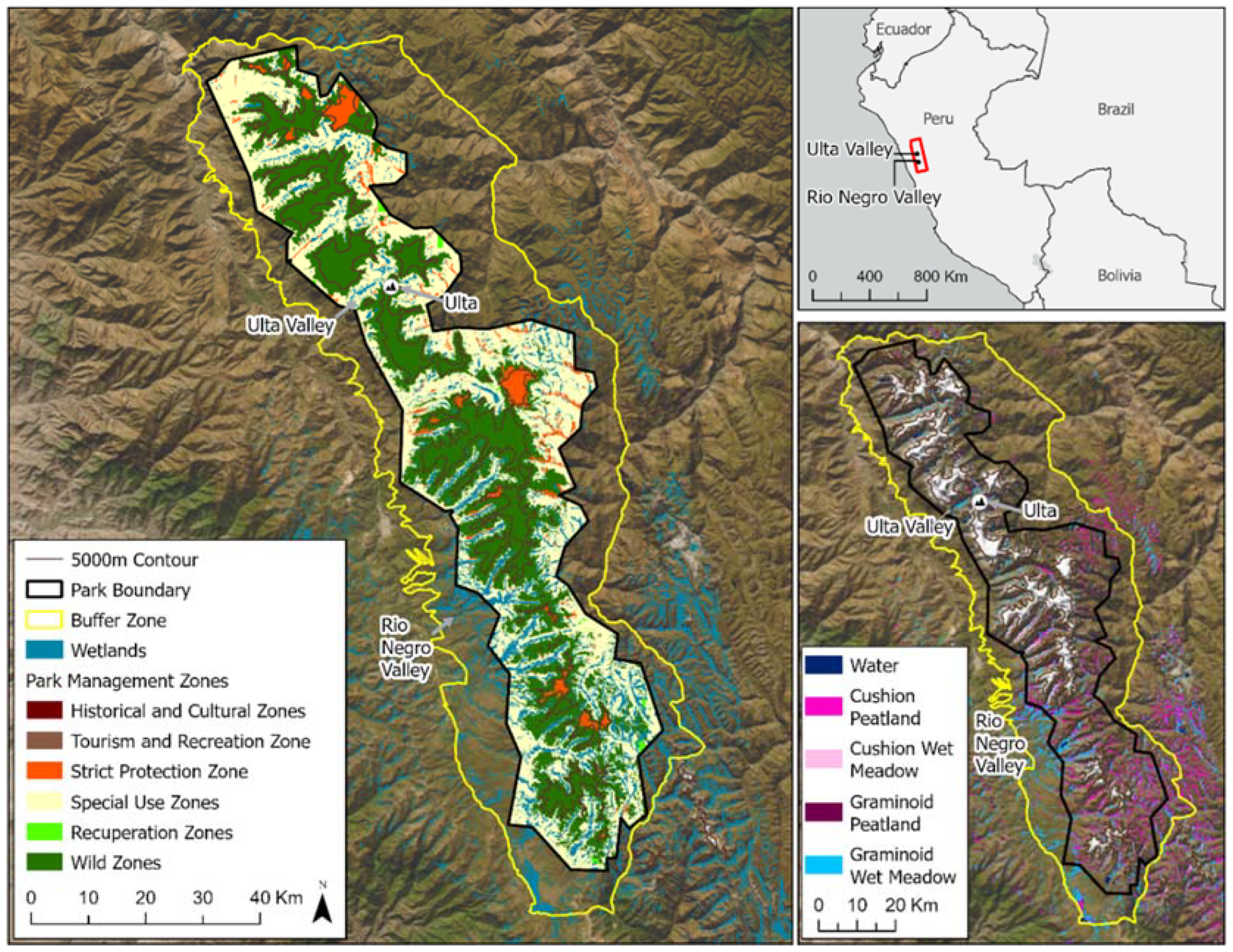
2. Study Area
3. Methods
4. Results
5. Discussion
Author Contributions
Funding
Data Availability Statement
Acknowledgments
Conflicts of Interest
References
- Watson, J.E.; Dudley, N.; Segan, D.B.; Hockings, M. The performance and potential of protected areas. Nature 2014, 515, 67–73. [Google Scholar] [CrossRef] [PubMed]
- Brockington, D.; Wilkie, D. Protected areas and poverty. Philos. Trans. R. Soc. B Biol. Sci. 2015, 370, 20140271. [Google Scholar] [CrossRef] [PubMed]
- Chou, S.; Lyra, A.; Mourão, C.; Dereczynski, C.; Pilotto, I.; Gomes, J.; Bustamante, J.; Tavares, P.; Silva, A.; Rodrigues, D.; et al. Assessment of Climate Change over South America under RCP 4.5 and 8.5 Downscaling Scenarios. Am. J. Clim. Change 2014, 3, 512–527. [Google Scholar] [CrossRef]
- Castellanos, E.; Lemos, M.F.; Astigarraga, L.; Chacón, N.; Cuvi, N.; Huggel, C.; Miranda, L.; Vale, M.M.; Ometto, J.P.; Peri, P.L.; et al. Central and South America. In Climate Change 2022: Impacts, Adaptation and Vulnerability. Contribution of Working Group II to the Sixth Assessment Report of the Intergovernmental Panel on Climate Change; Pörtner, H.-O., Roberts, D.C., Tignor, M., Poloczanska, E.S., Mintenbeck, K., Alegría, A., Craig, M., Langsdorf, S., Löschke, S., Möller, V., et al., Eds.; Cambridge University Press: Cambridge, UK; New York, NY, USA, 2022; pp. 1689–1816. [Google Scholar] [CrossRef]
- Malhi, Y.; Franklin, J.; Seddon, N.; Solan, M.; Turner, M.G.; Field, C.B.; Knowlton, N. Climate change and ecosystems: Threats, opportunities and solutions. Philos. Trans. R. Soc. B 2020, 375, 20190104. [Google Scholar] [CrossRef] [PubMed]
- UNEP. Scientific Blueprint to Tackle the Climate, Biodiversity and Pollution Emergencies. Nairobi. 2021. Available online: https://www.unep.org/resources/making-peace-nature (accessed on 5 November 2023).
- Ranius, T.; Widenfalk, L.A.; Seedre, M.; Lindman, L.; Felton, A.; Hämäläinen, A.; Filyushkina, A.; Öckinger, E. Protected area designation and management in a world of climate change: A review of recommendations. Ambio 2023, 52, 68–80. [Google Scholar] [CrossRef] [PubMed]
- Pennington, R.T.; Lavin, M.; Särkinen, T.; Lewis, G.P.; Klitgaard, B.B.; Hughes, C.E. Contrasting plant diversification histories within the Andean biodiversity hotspot. Proc. Natl. Acad. Sci. USA 2010, 107, 13783–13787. [Google Scholar] [CrossRef]
- Mark, B. Tracing tropical Andean glaciers over space and time: Some lessons and transdisciplinary implications. Glob. Planet. Change 2008, 60, 101–114. [Google Scholar] [CrossRef]
- Costanza, R.; d’Arge, R.; de Groot, R.; Farber, S.; Grasso, M.; Hannon, B.; Limburg, K.; Naeem, S.; O’Neill, R.V.; Paruelo, J.; et al. The value of the world’s ecosystem services and natural capital. Nature 1997, 387, 253–260. [Google Scholar] [CrossRef]
- Strack, M.; Davidson, S.J.; Hirano, T.; Dunn, C. The Potential of Peatlands as NatureBased Climate Solutions. Curr. Clim. Change Rep. 2022, 8, 71–82. [Google Scholar] [CrossRef]
- Page, S.E.; Baird, A.J. Peatlands and global change: Response and resilience. Annu. Rev. Environ. Resour. 2016, 41, 35–57. [Google Scholar] [CrossRef]
- UNEP. Global Peatlands Assessment—The State of the World’s Peatlands: Evidence for Action toward the Conservation, Restoration, and Sustainable Management of Peatlands. Main Report. Global Peatlands Initiative; United Nations Environment Programme: Nairobi, Kenya, 2022. [Google Scholar]
- Nahlik, A.M.; Fennessy, M.S. Carbon storage in US wetlands. Nat. Commun. 2016, 7, 13835. [Google Scholar] [CrossRef]
- Kolka, R.; Trettin, C.; Tang, W.; Krauss, K.; Bansal, S.; Drexler, J.K.; Wickland, R.; Chimner, D.; Hogan, E.J.; Pindilli, B.; et al. Chapter 13: Terrestrial wetlands. In Second State of the Carbon Cycle Report (SOCCR2): A Sustained Assessment Report; Cavallaro, N., Shrestha, G., Birdsey, R., Mayes, M.A., Najjar, R.G., Reed, S.C., Romero-Lankao, P., Zhu, Z., Eds.; U.S. Global Change Research Program: Washington, DC, USA, 2018; pp. 507–567. [Google Scholar]
- Cooper, D.J.; Chimner, R.A.; Merritt, D.M. Western Mountain Wetlands; University of California Press: Berkeley, CA, USA, 2012; pp. 313–328. [Google Scholar]
- Earle, L.R.; Warner, B.; Aravena, R. Rapid development of an unusual peat-accumulating ecosystem in the Chilean altiplano. Quat. Res. 2003, 59, 2–11. [Google Scholar] [CrossRef]
- Cooper, D.J.; Wolf, E.C.; Colson, C.; Vering, W.; Granda, A.; Meyer, M. Alpine Peatlands of the Andes, Cajamarca, Peru. Arct. Antarct. Alp. Res. 2010, 42, 19–33. [Google Scholar] [CrossRef]
- Maldonado Foncen, M.S. An introduction to the bofedales of the Peruvian High Andes. Mires Peat 2014, 15, 5. [Google Scholar]
- Salvador, F.; Monerris, J.; Rochefort, L. Peatlands of the Peruvian puna ecoregion: Types, characteristics and disturbance. Mires Peat 2014, 15, 1–17. [Google Scholar]
- Hribljan, J.A.; Suarez, E.; Bourgeau-Chavez, L.; Endres, S.; Lilleskov, E.A.; Chimbolema, S.; Wayson, C.; Serocki, E.; Chimner, R.A. Multidate, multisensor remote sensing reveals high density of carbon-rich mountain peatlands in the páramo of Ecuador. Glob. Change Biol. 2017, 23, 5412–5425. [Google Scholar] [CrossRef] [PubMed]
- Chimner, R.A.; Bourgeau-Chavez, L.L.; Grelik, S.; Hribljan, J.A.; Maria Planas Clarke, A.; Polk, M.H.; Lilleskov, E.A.; Fuentealba, B. Mapping extent and types of wetlands in the Cordillera Blanca, Peru. Wetlands 2019, 39, 1057–1067. [Google Scholar] [CrossRef]
- Chimner, R.A.; Resh, S.C.; Hribljan, J.A.; Battaglia, M.; Bourgeau-Chavez, L.; Bowser, G.; Lilleskov, E.A. Mountain Wetland Soil Carbon Stocks of Huascarán National Park, Peru. Front. Plant Sci. 2023, 14, 1048609. [Google Scholar] [CrossRef]
- Wolf, E.C.; Cooper, D.J. Fens of the Sierra Nevada, California, USA: Patterns of distribution and vegetation. Mires Peat 2015, 15, 1–22. [Google Scholar]
- Schook, D.M.; Borkenhagen, A.K.; McDaniel, P.A.; Wagner, J.I.; Cooper, D.J. Soils and hydrologic processes drive wet meadow formation and approaches to restoration, Western USA. Wetlands 2020, 40, 637–653. [Google Scholar] [CrossRef]
- Chimner, R.A.; Boone, R.; Bowser, G.; Bourgeau-Chavez, L.; Fuentealba, B.; Gilbert, J.; Ñaupari, J.A.; Polk, M.H.; Resh, S.; Turin, C.; et al. Andes, Bofedales, and the Communities of Huascarán National Park, Peru. Wetl. Sci. Pract. 2020, 37, 246–254. [Google Scholar]
- Carey, M.; Baraer, M.; Mark, B.G.; French, A.; Bury, J.; Young, K.R.; McKenzie, J.M. Toward hydro-social modeling: Merging human variables and the social sciences with climate-glacier runoff models (Santa River, Peru). J. Hydrol. 2014, 518, 60–70. [Google Scholar] [CrossRef]
- Enriquez, A.S.; Chimner, R.A.; Cremona, M.V. Long term grazing negatively affects nitrogen dynamics in Northern Patagonian wet meadows. J. Arid Environ. 2014, 109, 1–5. [Google Scholar] [CrossRef]
- Enriquez, A.S.; Chimner, R.A.; Diehl, P.; Cremona, M.V.; Bonvissuto, G.L. Grazing intensity and precipitation levels influence C reservoirs in Northern Patagonia wet and mesic meadows. Wetl. Ecol. Manag. 2015, 23, 439–451. [Google Scholar] [CrossRef]
- Young, K.R.; Ponette-González, A.; Polk, M.H.; Lipton, J.K. Snowlines and treelines in the tropical Andes. Ann. Am. Assoc. Geogr. 2017, 107, 429–440. [Google Scholar] [CrossRef]
- Young, K.R.; Lipton, J.K. Adaptive governance and climate change in the tropical highlands of western South America. Clim. Change 2006, 78, 63–102. [Google Scholar] [CrossRef]
- Anderson, E.P.; Marengo, J.; Villalba, R.; Halloy, S.; Young, B.; Cordero, D.; Gast, F.; Jaimes, E.; Ruiz, D.; Herzog, S.K.; et al. Consequences of climate change for ecosystems and ecosystem services in the tropical Andes. In Climate Change and Biodiversity in the Tropical Andes; Herzog, S.K., Martínez, R., Jørgensen, P.M., Tiessen, H., Eds.; Inter-American Institute for Global Change Research (IAI) and Scientific Committee on Problems of the Environment (SCOPE): Montevideo, Uruguay, 2011; 348p. [Google Scholar]
- Flores, E. Cambio climático: Pastizales Altoandinos y seguridad alimentaria. Rev. Glaciares Ecosist. Montaña 2016, 1, 13. [Google Scholar] [CrossRef]
- IPCC. IPCC Special Report on the Ocean and Cryosphere in a Changing Climate; Po, H.-O., Roberts, D.C., Masson-Delmotte, V., Zhai, P., Tignor, M., Poloczanska, E., Mintenbeck, K., Alegri, A., Nicolai, M., Okem, A., et al., Eds.; IPCC: Geneva, Switzerland, 2019. [Google Scholar]
- Mark, B.; French, A.; Bury, J.; Carey, M.; Young, K.; Wigmore, O.; Polk, M.H.; McKenzie, J.; Lautz, L.; Crumley, R.; et al. Glacier loss and hydro-social risks in the Peruvian Andes. Glob. Planet. Change 2017, 159, 61–76. [Google Scholar] [CrossRef]
- Postigo, J.C. Perception and resilience of Andean populations facing climate change. J. Ethnobiol. 2014, 34, 383–400. [Google Scholar] [CrossRef]
- Palacios, F. Pastizales de regadío para alpacas. In Pastores de Puna. Uywamichiq Punarunakuna; Flores Ochoa, J., Ed.; Instituto de Estudios Peruanos: Lima, Peru, 1977; pp. 155–191. [Google Scholar]
- Yager, K.; Valdivia, C.; Slayback, D.; Jimenez, E.; Meneses, R.I.; Palabral, A.; Bracho, M.; Romero, D.; Hubbard, A.; Pacheco, P.; et al. Socio-ecological dimensions of Andean pastoral landscape change: Bridging traditional ecological knowledge and satellite image analysis in Sajama National Park, Bolivia. Reg. Environ. Change 2019, 19, 1353–1369. [Google Scholar] [CrossRef]
- Monge-Salazar, M.J.; Tovar, C.; Cuadros-Adriazola, J.; Baiker, J.R.; Montesinos-Tubée, D.B.; Bonnesoeur, V.; Antiporta, J.; Román-Dañobeytia, F.; Fuentealba, B.; Ochoa-Tocachi, B.F.; et al. Ecohydrology and ecosystem services of a natural and an artificial bofedal wetland in the central Andes. Sci. Total Environ. 2022, 838, 155968. [Google Scholar] [CrossRef] [PubMed]
- Morlon, P.; Cobo, B.; Orlove, B.; Palacios Rios, F.; Felipe-Morales, C.; Reynel, C.; Rozas, W. Capítulo 4. Infraestructuras agrícolas: ¿Vestigios del pasado o técnicas para el futuro? In Comprender la Agricultura Campesina en los Andes Centrales: Perú-Bolivia; Morlon, P., Ed.; Institut Français d’études Andines: Lima, Peru, 1996. [Google Scholar] [CrossRef]
- Lane, K. Engineering the Puna: The Hydraulics of Agro-Pastoral Communities in a Northcentral Peruvian Valley. Ph.D. Thesis, University of Cambridge, Cambridgem, UK, 2006. [Google Scholar]
- Lane, K. Water Technology in the Andes. In Encyclopaedia of the History of Science, Technology, and Medicine in Non-Western Cultures; Selin, H., Ed.; Springer: Dordrecht, The Netherlands, 2014. [Google Scholar]
- Palacios, F. Tecnología del Pastoreo. In La Tecnología en el Mundo Andino. Runakunap Kawsayninkupaq Rurasqankunaqa; Lechaman, H., Soleli, A.M., Tomo, I., Eds.; Universidad Nacional Autónoma de México: Autónoma de México, México, 1981; pp. 217–232. [Google Scholar]
- Briske, D.D. Rangeland Systems: Processes, Management and Challenges; Springer Nature: Berlin/Heidelberg, Germany, 2017; p. 661. [Google Scholar]
- Bourgeau-Chavez, L.L.; Endres, S.L.; Graham, J.A.; Hribljan, J.A.; Chimner, R.A.; Lillieskov, E.A.; Battaglia, M.J. 2018. Mapping Peatlands in Boreal and Tropical Ecoregions. In Comprehensive Remote Sensing; Liang, S., Ed.; Elsevier: Oxford, UK, 2018; Volume 6, pp. 24–44. [Google Scholar]
- Ulander, L.M.H. Radiometric slope correction of synthetic-aperture radar images. IEEE Trans. Geosci. Remote Sens. 1996, 34, 1115–1122. [Google Scholar] [CrossRef]
- Planas-Clarke, A.M.; Chimner, R.A.; Hribljan, J.A.; Lilleskov, E.A.; Fuentealba, B. The effect of water table levels and short-term ditch restoration on mountain peatland carbon cycling in the Cordillera Blanca, Peru. Wetl. Ecol. Manag. 2020, 28, 51–69. [Google Scholar] [CrossRef]
- Yager, K.; Prieto, M.; Meneses, R.I. Reframing pastoral practices of bofedal management to increase the resilience of Andean water towers. Mt. Res. Dev. 2021, 41, A1–A9. [Google Scholar] [CrossRef]
- Valdivia, C. Diversification as a risk management strategy in an Andean Agropastoral community. Am. J. Agric. Econ. 1996, 78, 1329–1334. [Google Scholar] [CrossRef]
- Chimner, R.A.; Cooper, D.J.; Lemly, J.M. Mountain fen distribution, types and restoration priorities, San Juan Mountains, Colorado, USA. Wetlands 2010, 30, 763–771. [Google Scholar] [CrossRef]
- Chimner, R.A.; Bonvissuto, G.L.; Cremona, M.V.; Gaitan, J.J.; Lopez, C.R. Ecohydrological conditions of wetlands along a precipitation gradient in Patagonia, Argentina. Ecol. Austral. 2011, 21, 329–337. [Google Scholar]
- Sánchez, M.E.; Chimner, R.A.; Hribljan, J.A.; Lilleskov, E.A.; Suárez, E. Carbon dioxide and methane fluxes in grazed and ungrazed mountain peatlands in the Ecuadorian Andes. Mires Peat 2017, 19, 1–18. [Google Scholar] [CrossRef]
- Fjeldså, J. The Avifauna of the Polylepis Woodlands of the Andean Highlands: The Efficiency of Basing Conservation Priorities on Patterns of Endemism. Bird Conserv. Int. 1993, 3, 37–55. [Google Scholar] [CrossRef]
- Yensen, E.; Tarifa, T. Mammals of Bolivian Polylepis woodlands: Guild structure and diversity patterns in the world’s highest woodlands. Ecotropica 2002, 8, 145–162. [Google Scholar]
- Lloyd, H.; Marsden, S.J. Bird community variation across Polylepis woodland fragments and matrix habitats: Implications for biodiversity conservation within a high Andean landscape. Biodivers. Conserv. 2008, 17, 2645–2660. [Google Scholar] [CrossRef]
- Gareca, E.E.; Hermy, M.; Fjeldså, J.; Honnay, O. Polylepis woodland remnants as biodiversity islands in the Bolivian High Andes. Biodivers. Conserv. 2010, 19, 3327–3346. [Google Scholar] [CrossRef]
- Abdalla, M.; Hastings, A.; Truu, J.; Espenberg, M.; Mander, Ü.; Smith, P. Emissions of methane from northern peatlands: A review of management impacts and implications for future management options. Ecol. Evol. 2016, 6, 7080–7102. [Google Scholar] [CrossRef] [PubMed]
- Dobrowski, S.Z. A climatic basis for microrefugia: The influence of terrain on climate. Glob. Change Biol. 2011, 17, 1022–1035. [Google Scholar] [CrossRef]
- Michalak, J.L.; Stralberg, D.; Cartwright, J.M.; Lawler, J.J. Combining physical and species-based approaches improves refugia identification. Front. Ecol. Environ. 2020, 18, 254–260. [Google Scholar] [CrossRef]
- Turin, C.; Valdivia, C. Off-farm work in the Peruvian Altiplano: Seasonal and Geographic Considerations for Agricultural and Development Policies. In Seasonality, Rural Livelihoods and Development; Deveraux, S., Sabates-Wheeler, R., Longhurst, R., Chambers, R., Eds.; Routledge: London, UK, 2012; Ch09; pp. 145–160. [Google Scholar] [CrossRef]
- Turin, C. Perceptions of Rangeland Degradation and Its Causes in the Peruvian Altiplano Dry Puna. Ph.D. Thesis, University of Missouri-Columbia, Columbia, MO, USA, 2019. Available online: https://mospace.umsystem.edu/xmlui/handle/10355/71841 (accessed on 9 November 2023).
- Alarcon, J.A.; Flores, E.; Barrantes, C. Determination of the availability of payment for conservation and improvement activities of wetlands ecosystem of the Huaraz City, Peru. J. Environ. Pollut. Manag. 2018, 1, 105. [Google Scholar]
- Coppock, L.; Fernandez-Gimenez, M.; Hiernaux, P.; Huber-Sannwald, E.; Schloeder, C.; Valdivia, C.; Turin, C.; Turner, M.; Jacobs, M.; Arredondo, J. Rangelands in Developing Nations: Conceptual advances and societal implications. In Rangeland Systems. Processes, Management and Challenges; Briske, D., Ed.; Springer: Berlin/Heidelberg, Germany, 2017; ISBN 978-3-319-46709-2. Available online: http://www.springer.com/us/book/9783319467078 (accessed on 9 November 2023).
- Roy, H.E.; Baxter, E.; Saunders, A.; Pocock, M.J.O. Focal plant observations as a standardised method for pollinator monitoring: Opportunities and limitations for mass participation Citizen Science. PLoS ONE 2016, 11, e0150794. [Google Scholar]
- Ward, D.F.; Lariviere, M.C. Terrestrial invertebrate surveys and rapid biodiversity assessment in New Zealand: Lessons from Australia. N. Z. J. Ecol. 2004, 28, 151–159. [Google Scholar]
- Polk, M.H. They Are Drying Out: Social-Ecological Consequences of Glacier Recession on Mountain Peatlands in Huascarán National Park, Peru. Doctoral Dissertation, The University of Texas at Austin, Austin, TX, USA, 2016. [Google Scholar]
- Robertson, H.A.; McGee, T.K. Applying local knowledge: The contribution of oral history to wetland rehabilitation at Kanyapella Basin, Australia. J. Environ. Manag. 2003, 69, 275–287. [Google Scholar] [CrossRef]
- Hanson, A.M. Shoes in the seaweed and bottles on the beach. In A Political Ecology of Women, Water and Global Environmental Change; Buechler, S., Hanson, A.-M., Eds.; Routledge: New York, NY, USA, 2016; pp. 165–184. [Google Scholar]
- Boone, R.B.; Galvin, K.A.; BurnSilver, S.B.; Thornton, P.K.; Ojima, D.S.; Jawson, J.R. Using coupled simulation models to link pastoral decision making and ecosystem services. Ecol. Soc. 2011, 16, 6. [Google Scholar] [CrossRef]
- Boone, R.B.; Conant, R.T.; Sircely, J.; Thornton, P.K.; Herrero, M. Climate change impacts on selected global rangeland ecosystem services. Glob. Change Biol. 2018, 24, 1382–1393. [Google Scholar] [CrossRef]
- Sircely, J.; Boone, R.B.; Conant, R. Simulating rangeland ecosystem and vegetation dynamics with G-Range: Model description and evaluation at site and global scales. Rangel. Ecol. Manag. 2019, 72, 846–857. [Google Scholar] [CrossRef]
- Chambers, R. Participatory mapping and geographic information systems: Whose map? Who is empowered and who disempowered? Who gains and who loses? Electron. J. Inf. Syst. Dev. Ctries. 2006, 25, 1–11. [Google Scholar] [CrossRef]
- Young, K.R. Andean land use and biodiversity: Humanized landscapes in a time of change. Ann. Mo. Bot. Gard. 2009, 96, 492–507. [Google Scholar] [CrossRef]
- Bury, J.; Mark, B.G.; Carey, M.; Young, K.R.; McKenzie, J.; Baraer, M.; French, A.; Polk, M.H. New geographies of water and climate change in Peru: Coupled natural and social transformations in the Santa River watershed. Ann. Assoc. Am. Geogr. 2013, 103, 363–374. [Google Scholar] [CrossRef]
- López-i-Gelats, F.; Contreras Paco, J.L.; Huilcas Huayra, R.; Siguas Robles, O.D.; Quispe Peña, E.C.; Bartolomé Filella, J. Adaptation strategies of Andean pastoralist households to both climate and non-climate changes. Hum. Ecol. 2015, 43, 267–282. [Google Scholar] [CrossRef]
- Rolando, J.L.; Turin, C.; Ramírez, D.A.; Mares, V.; Monerris, J.; Quiroz, R. Key ecosystem services and ecological intensification of agriculture in the tropical High-Andean Puna as affected by land-use and climate changes. Agric. Ecosyst. Environ. 2017, 236, 221–223. [Google Scholar] [CrossRef]
- Hulvey, K.B.; Mellon, C.D.; Kleinhesselink, A.R. Rotational grazing can mitigate ecosystem service trade-offs between livestock production and water quality in semi-arid rangelands. J. Appl. Ecol. 2021, 58, 2113–2123. [Google Scholar] [CrossRef]
- Pavlů, V.; Hejcman, M.; Pavlů, L.; Gaisler, J. Effect of rotational and continuous grazing on vegetation of an upland grassland in the Jizerské Hory Mts., Czech Republic. Folia Geobot. 2003, 38, 21–34. [Google Scholar] [CrossRef]
- Byrnes, R.C.; Eastburn, D.J.; Tate, K.W.; Roche, L.M. A global meta-analysis of grazing impacts on soil health indicators. J. Environ. Qual. 2018, 47, 758–765. [Google Scholar] [CrossRef]
- Dong, S.; Zhang, Y.; Shen, H.; Li, S.; Xu, Y. Grazing Management and Pastoral Production. In Grasslands on the Third Pole of the World: Structure, Function, Process, and Resilience of Social-Ecological Systems; Springer International Publishing: Cham, Switzerland, 2023; pp. 199–230. [Google Scholar]
- Ingty, T. Pastoralism in the highest peaks: Role of the traditional grazing systems in maintaining biodiversity and ecosystem function in the alpine Himalaya. PLoS ONE 2021, 16, e0245221. [Google Scholar] [CrossRef] [PubMed]
- Mu, J.; Zeng, Y.; Wu, Q.; Niklas, K.J.; Niu, K. Traditional grazing regimes promote biodiversity and increase nectar production in Tibetan alpine meadows. Agric. Ecosyst. Environ. 2016, 233, 336–342. [Google Scholar] [CrossRef]


Disclaimer/Publisher’s Note: The statements, opinions and data contained in all publications are solely those of the individual author(s) and contributor(s) and not of MDPI and/or the editor(s). MDPI and/or the editor(s) disclaim responsibility for any injury to people or property resulting from any ideas, methods, instructions or products referred to in the content. |
© 2023 by the authors. Licensee MDPI, Basel, Switzerland. This article is an open access article distributed under the terms and conditions of the Creative Commons Attribution (CC BY) license (https://creativecommons.org/licenses/by/4.0/).
Share and Cite
Young, K.R.; Alata, E.; Chimner, R.A.; Boone, R.B.; Bowser, G.; Bourgeau-Chavez, L.; Fuentealba, B.; Gilbert, J.; Ñaupari, J.A.; Polk, M.H.; et al. Ecological Change and Livestock Governance in a Peruvian National Park. Land 2023, 12, 2051. https://doi.org/10.3390/land12112051
Young KR, Alata E, Chimner RA, Boone RB, Bowser G, Bourgeau-Chavez L, Fuentealba B, Gilbert J, Ñaupari JA, Polk MH, et al. Ecological Change and Livestock Governance in a Peruvian National Park. Land. 2023; 12(11):2051. https://doi.org/10.3390/land12112051
Chicago/Turabian StyleYoung, Kenneth R., Eyner Alata, Rodney A. Chimner, Randall B. Boone, Gillian Bowser, Laura Bourgeau-Chavez, Beatriz Fuentealba, Jessica Gilbert, Javier A. Ñaupari, Molly H. Polk, and et al. 2023. "Ecological Change and Livestock Governance in a Peruvian National Park" Land 12, no. 11: 2051. https://doi.org/10.3390/land12112051
APA StyleYoung, K. R., Alata, E., Chimner, R. A., Boone, R. B., Bowser, G., Bourgeau-Chavez, L., Fuentealba, B., Gilbert, J., Ñaupari, J. A., Polk, M. H., Resh, S. C., Turin, C., & Zarria-Samanamud, M. (2023). Ecological Change and Livestock Governance in a Peruvian National Park. Land, 12(11), 2051. https://doi.org/10.3390/land12112051