1. Introduction
Arabica coffee (
Coffea arabica) accounts for ~70% of coffee production worldwide, growing mainly in shaded and non-shaded systems in many tropical regions. Traditional shaded agroforestry plantations are highly valued due to their ecological, environmental, economic, and social benefits [
1,
2,
3]. The implementation of agroforestry systems, i.e., land-use systems where trees and crops are purposefully planted on the same piece of land, have been extensively proposed as a means of reducing soil erosion risks, improving soil’s hydraulic characteristics, soil hydrological and physical properties, and enhancing overall systems resilience [
1,
4,
5,
6]. Due to global climate change (long dry seasons, change in mean temperatures, low minimum temperature, and annual precipitation), coffee production has been affected negatively in all main producing regions [
7]. Responsively, new shade-grown coffee agroecosystems have been emerging in human-impacted landscapes as a consequence of land-use change because of economic, ecological, and social reasons. These new agroforestry systems contribute to enhanced hydrological ecosystem services by improving soil infiltration, thereby contributing to the resilience of agricultural systems [
5].
Soil hydraulic properties, including infiltration and hydraulic conductivity, are highly sensitive to land-use change, in terms of magnitude and variability. Thus, these properties are key elements to assess the function provided by new coffee agroecosystems and the strategies for climate change adaption [
8]. In this study, we selected the soil saturated hydraulic conductivity (Ks) as a main indicator to describe soil physical and hydraulic properties. The spatial elements that influence Ks values include soil moisture and temperature, root and fauna-created channels, fissures between soil aggregates, and vegetation that can establish species-specific litter quality control [
8]. Soil physical and hydraulic quality indicators are linked to the soil´s ability to hold and transmit water and air [
9]. Ks controls hydrologic processes such as rainfall infiltration and surface runoff and is sensible to soil disturbance, thus it has been frequently used as a land-use change indicator to describe the alteration of infiltration and soil hydrological influence [
10,
11,
12,
13]. Furthermore, the variable Ks has been used to study the impact of coffee and cocoa agroforestry systems on soil hydrological functions, showing a positive effect of trees on soil hydrological functioning in agroforestry systems [
5,
11].
Soil hydraulic properties vary greatly in space and time. A large number of measurements are required to assess the magnitude of the variation within the chosen area [
13]. Traditional methods for determining soil hydrological processes are costly and time consuming [
14]. Evaluating the impact of soil usage on the environment may necessitate extensive and time-consuming experimental efforts. Thus, the ability to estimate soil’s physical and hydraulic properties in a simple, inexpensive, and accurate manner is appealing for agronomic assessments [
15]. The steady version of the simplified method based on a Beerkan Infiltration run (SSBI method) proposed by Bagarello et al. [
16], which presents a low-cost and easy to implement alternative. The SSBI method makes use of the cumulative infiltration curve but does not require additional field and laboratory measurements to estimate Ks, such as initial and final soil water content, particle size distribution, or bulk density [
17]. Previous investigations on the same area suggest that the SSBI methodology is considered as a compromise between measurement reliability, applicative simplicity, and need for repeated sampling in space and time [
15,
18]. Furthermore, the SSBI method has been used as a robust methodology in previous studies to avoid uncertainties due to a specific shape of the cumulative infiltration [
19,
20] and has been recommended to be used instead of the BEST-steady method to avoid analysis failure in the case of soil hydrophobicity in tropical forests [
21]. Many studies have tested and used the SSBI method to determine the hydraulic properties of different tropical land-use systems [
21,
22,
23].
Other studies have shown that there is a strong relationship between shadow cover, soil moisture, soil temperature, and soil evaporation rates [
1,
3,
24]. Therefore, we included a one-time measurement of volumetric water content (VWC) with a time-domain reflectometry sensor to assess soil moisture in a specific moment in time under the same conditions in every study site. Additionally, we measured the surface temperature above organic matter (TAL) and below it (TBL) to assess the influence of leaf litter and grass on soil temperature. These methodologies were chosen because they require little equipment, are low cost, and can be easily replicated across a large area.
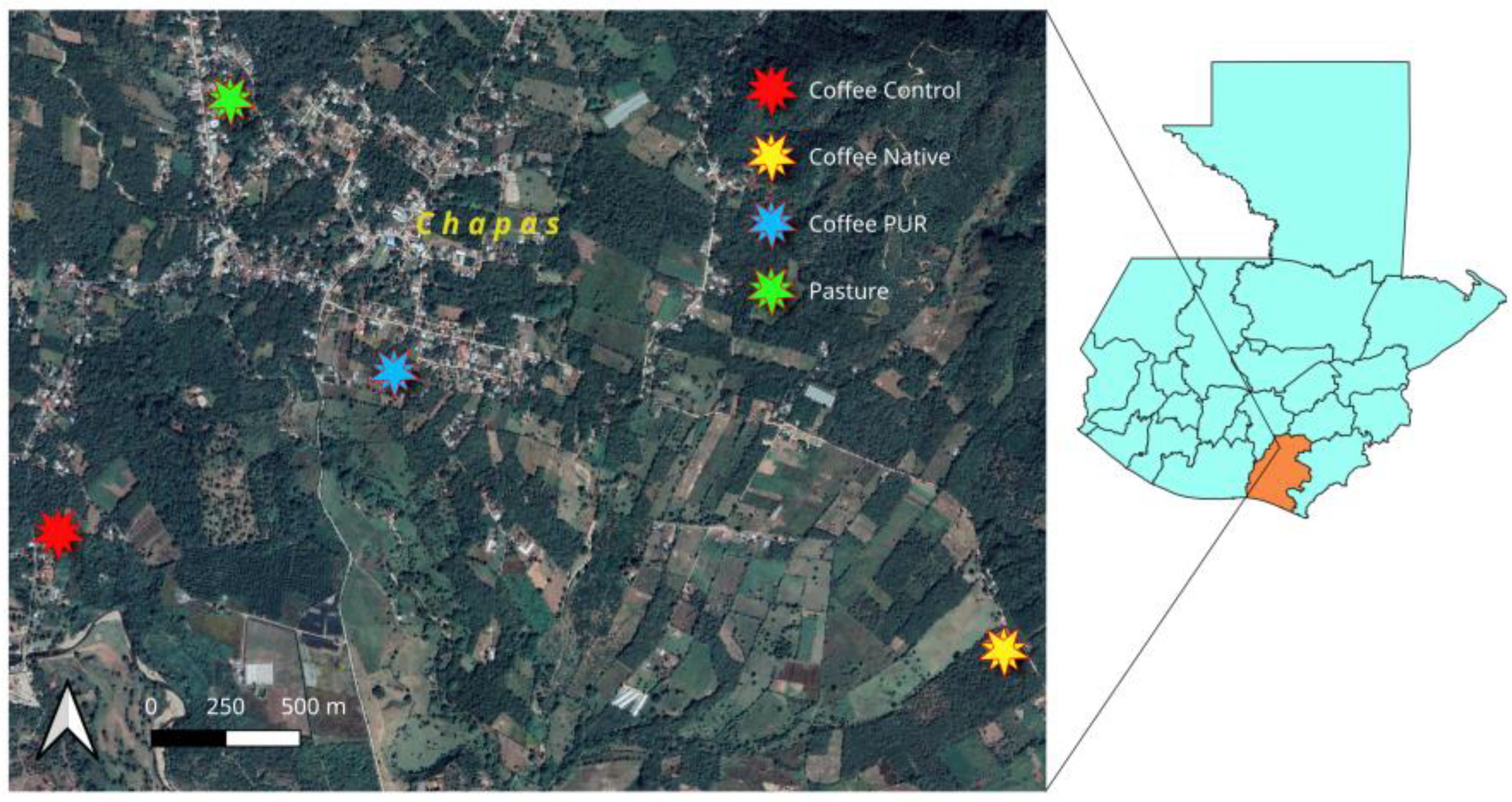
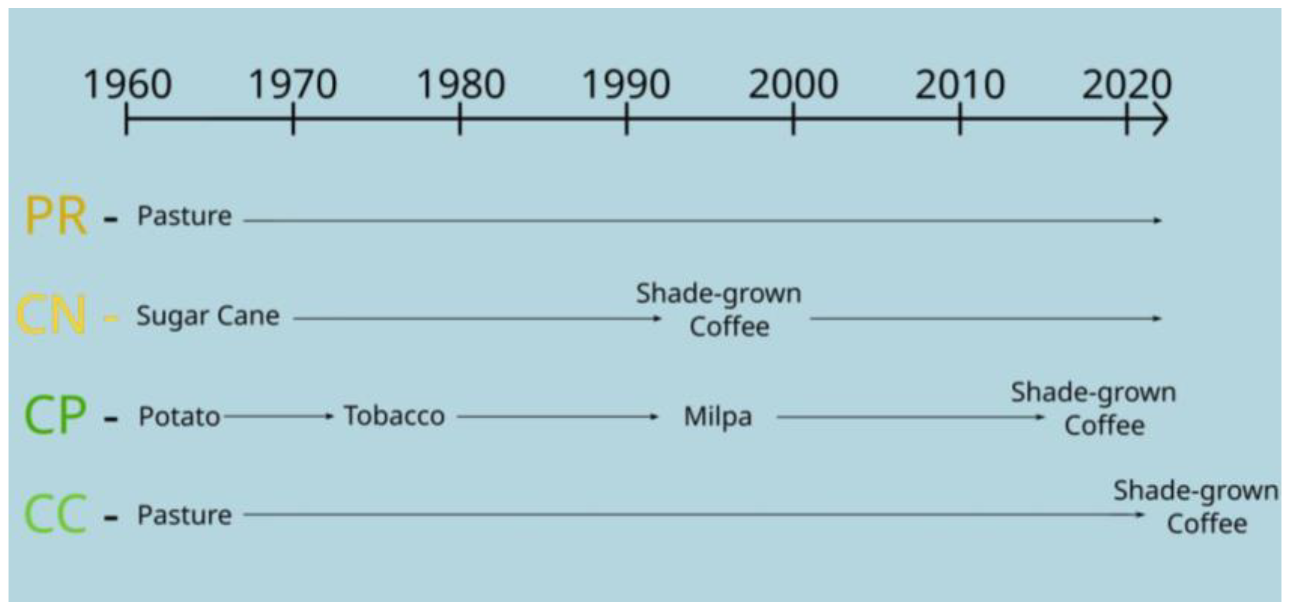
The present study aims to investigate the effect of agroforestry systems on soil physical and hydraulic properties in rainfed coffee farms of varying shade cover and age of the agroforestry system using low-cost and easy to implement methodologies. Important factors are the time needed to perform the measurements, the cost of materials, the cost of laboratory analysis, transport, and labor. Several studies regarding physical and hydraulic properties of soil have been carried out in Santa Rosa, Guatemala. Due to the absence of data about soil conditions of the coffee agroforestry system prior to the coffee plantation, we selected four land-use systems to replicate the influence of land-use systems over time in the region. A non-commercial pasture was included in the investigation to compare soil attributes to a non-agroforestry system within the same study area, resulting in a total of four land-use types: (i) a thirty-year-old shade-grown coffee (CN); (ii) a seven-year-old shade-grown coffee (CP); (iii) a one-year-old shade-grown coffee (CC); and a non-commercial pasture (PR). At each study site, we measured and compared Ks, TAL, TBL, and VWC. All four sites are located within the municipality of Nueva Santa Rosa, Santa Rosa department, Guatemala. So far, no studies have investigated the Ks values at different stages of coffee agroecosystems in time in this region. Following the findings that shaded agroforestry systems incorporating trees and cover crops improve soil physical, biochemical and biological components [
25,
26], and that forest regrowth promotes higher Ks increasing progressively over time [
5,
22,
27], and that the amount of shaded cover is directly related to the variability of soil moisture for the crop of interest and it is capable of reducing overall evaporative demand from soil evaporation [
1,
24], we hypothesized that mean Ks and mean VWC values would vary with the amount of canopy cover and age of the agroforestry trees in the system (CN > CP > CC = PR). Following the findings that shaded agroforestry systems improve microclimate conditions and soil temperature is lower under shaded conditions [
1,
24,
28], we hypothesized that TAL would vary with canopy cover (CC > PR > CP > CN): if the canopy cover is higher, less solar radiation will fall over the soil and temperature will be lower than that observed in land-use systems with lower canopy cover. Because the CC site is only one year old, no difference in plantation age was made between CC and PR. The PR site has higher soil cover, supporting the hypothesis that TAL would be lower than in CC.
Finally, to develop low-cost, easy to implement, and practical soil assessment tools for farmers, we used a soil visual evaluation tool developed by the Catholic Relief Service for coffee soils in Central America [
29]. We hypothesized that the scores for the soil visual assessment would vary with the age of the agroforestry system (CN > CP > CC = PR). Starting from the findings that coffee agroforestry systems can increase overall soil physical, biochemical, and biological components compared to non-shaded systems [
5,
26,
30], and that conventional coffee management can lead to higher soil erosion, decreasing overall soil health [
1,
31], we hypothesized that the scores for the soil visual assessment would vary with the age of the agroforestry system (CN > CP > CC = PR). This assumption leads to a conclusion that coffee agroforestry systems improve the overall soil health over time.
3. Results
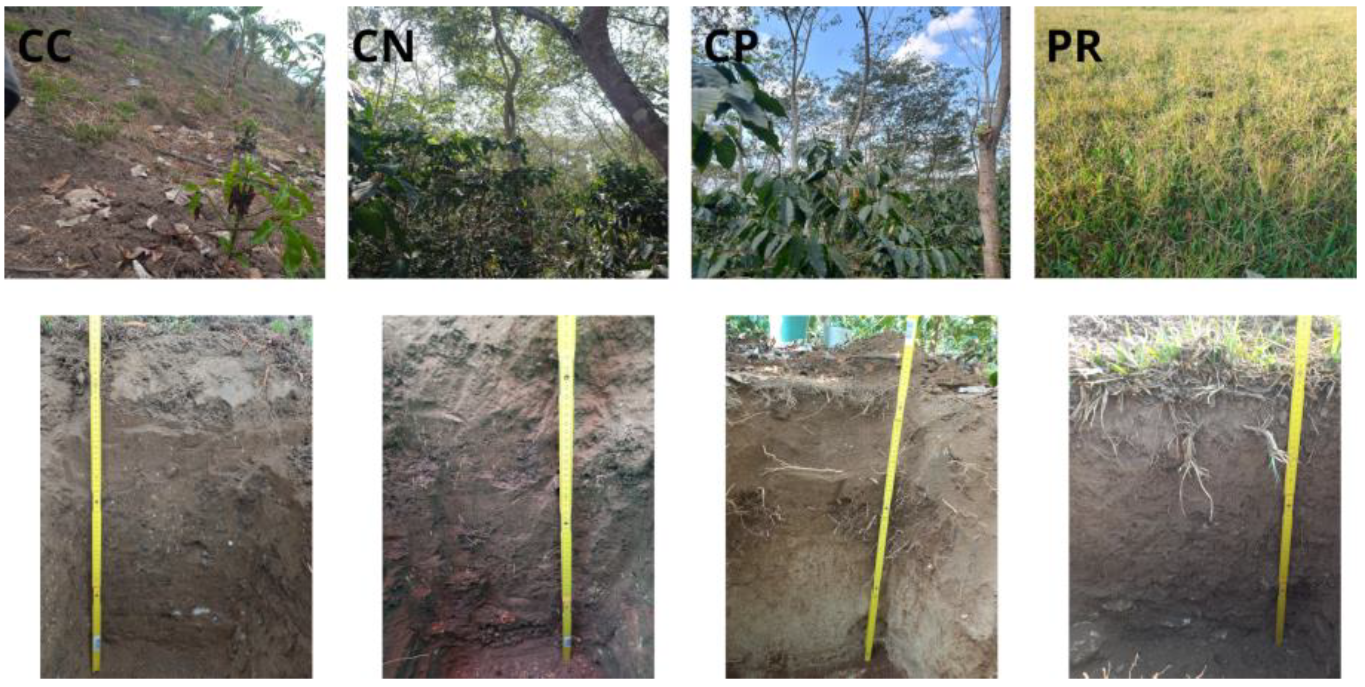
The vegetation characteristics show that the CN site has a significant higher canopy cover than the CP site (
Table 2). Otherwise, vegetation height of tree and DBH are highly similar between both land-use types.
The CC, CN, and CP sites had similar percentage of live biomass as soil cover (
Table 3), all between 21 and 30%. Most live biomass in the CN and CP sites were fern, creeping plants, and broad leaf plants such as
Achiyranthes aspera L. and
Ipomoea purpurea L. Otherwise, the live biomass on CC site includes mainly herbaceous vegetation, as it was converted from pasture to coffee plantation one year before. The PR site was covered entirely by live biomass, herbaceous vegetation. The CN site and CP site had a very high dead biomass percentage of soil cover, mainly leaf litter from the trees within the plots. The CC site had little dead biomass, mostly dead grass used as mulch. The site with the highest percentage of bare soil was CC. The other sites had no to a very low percentage of bare soil.
The texture of the first 0–30 cm of soil is sandy loam in CC, while it is sandy clay loam in CN, CP, and PR sites (
Table 4). The clay content is the lowest for the CC site with 7%. For the other sites, the clay content ranges between 21% and 34%. The silt content ranges between 18% and 31%, while the CC site has the lowest silt content, the PR site has the highest silt content. The sand content varies between 35% and 76%, with considerably higher sand values in CP and lower values in PR. The bulk density (ρb) values range from 1.05 to 1.18 g cm
−3, with higher similarities between CC and CP, the lowest value for PR and the highest for CN. Comparisons of field capacity (θfc) values between studies depict similar values for CC with 0.2227 cm
3 cm
−3, CN with 0.2541 cm
3 cm
−3, and CP with 0.2196 cm
3 cm
−3, and a considerably higher values for PR with 0.3207 cm
3 cm
−3. The same observation is made for θfc applied to the permanent wilting point (θpm), with PR having the highest value with 0.2008 cm
3 cm
−3. The pH has similar values in all study sites, ranging from 4.4 to 5.0.
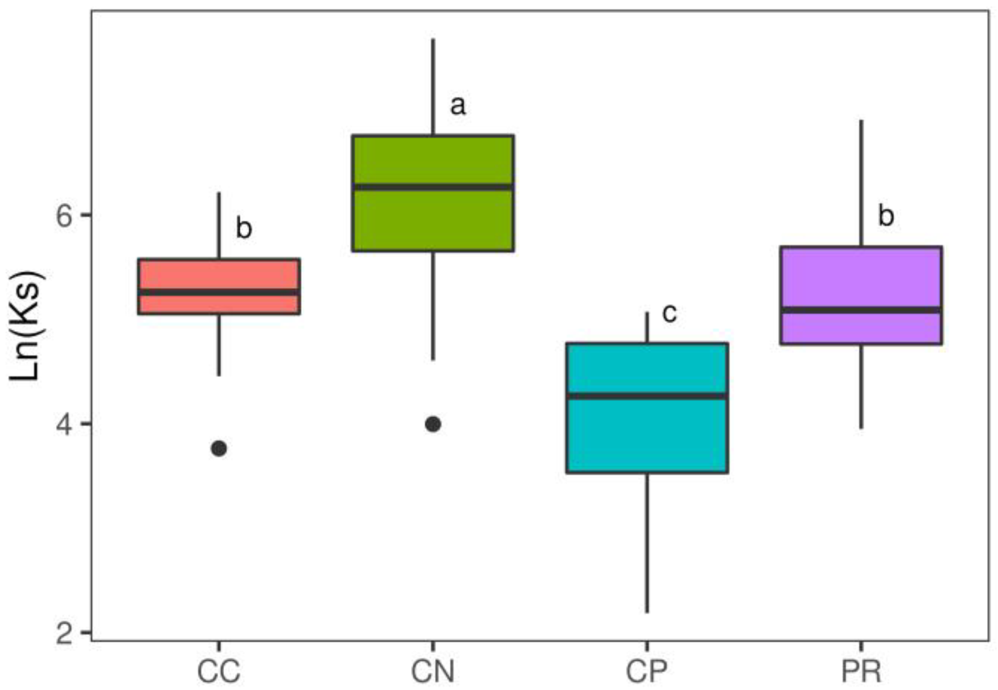
The Ks (
Figure 4) is significantly lower for CP (range: 9 to 160 mm h
−1) in comparison to the other sites and CN has significantly higher Ks values (range: 54 to 2185 mm h
−1). There is no significant difference between CC and PR in terms of Ks (range: 43 to 1004 mm h
−1) (
Table 5). A higher variability of Ks values is observed for CN, CP, and PR study sites. In contrast, smaller variations are evidenced in CC.
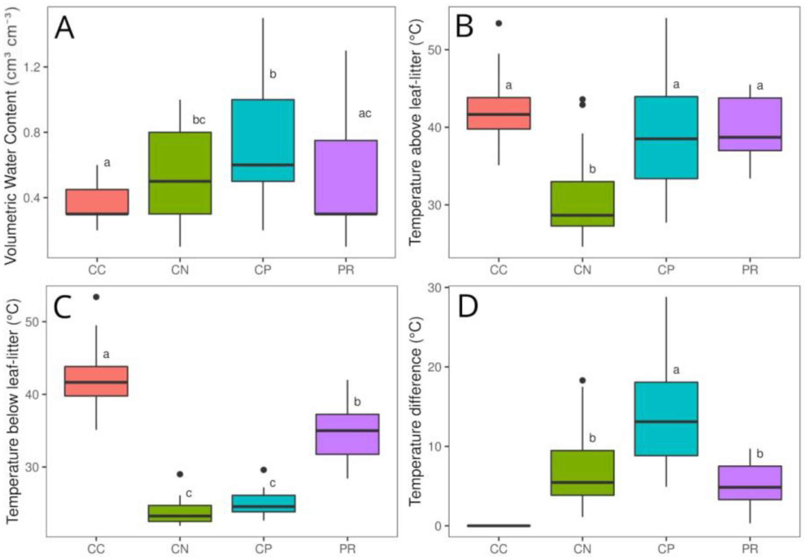
The volumetric water content shows significant higher values for CP and CN than CC and PR. We highlight that CN and PR has no statistically significant difference, as well as PR and CC. Nevertheless, CC has significantly lower values compared to CN (
Figure 5A). The temperature above leaf litter (TAL) is significantly lower between CN (range: 24 to 44 in °C) and CC, CP, and PR (range: 27 to 54 in °C). For temperature below soil cover, we observe the higher similarity between CC and PR (range: 28 to 53 in °C), and CN and CP (range: 21 to 29 in °C). The temperature difference ranges between 0.3 °C and 28.9 °C. It shows significant differences in CP with CN and PR.
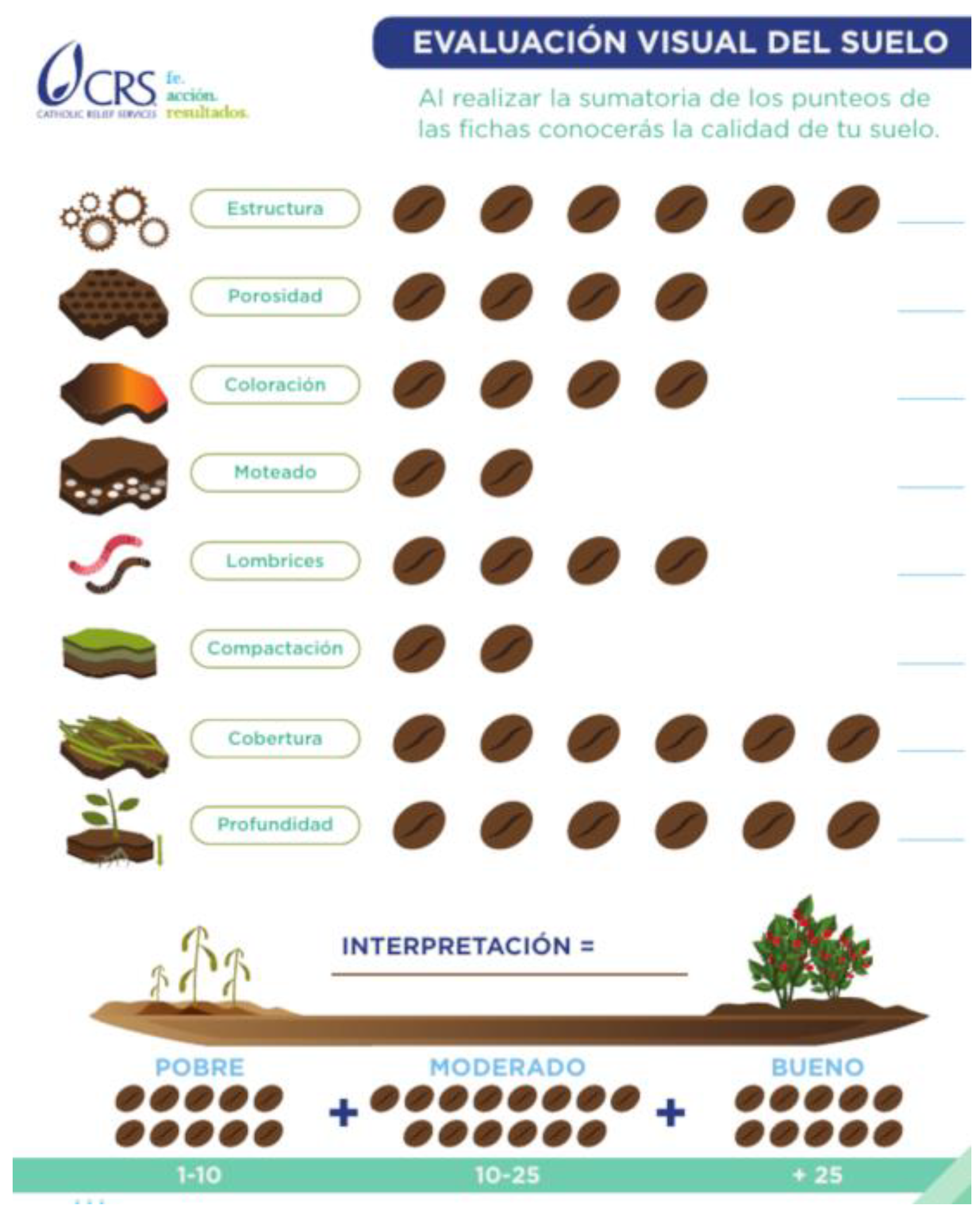
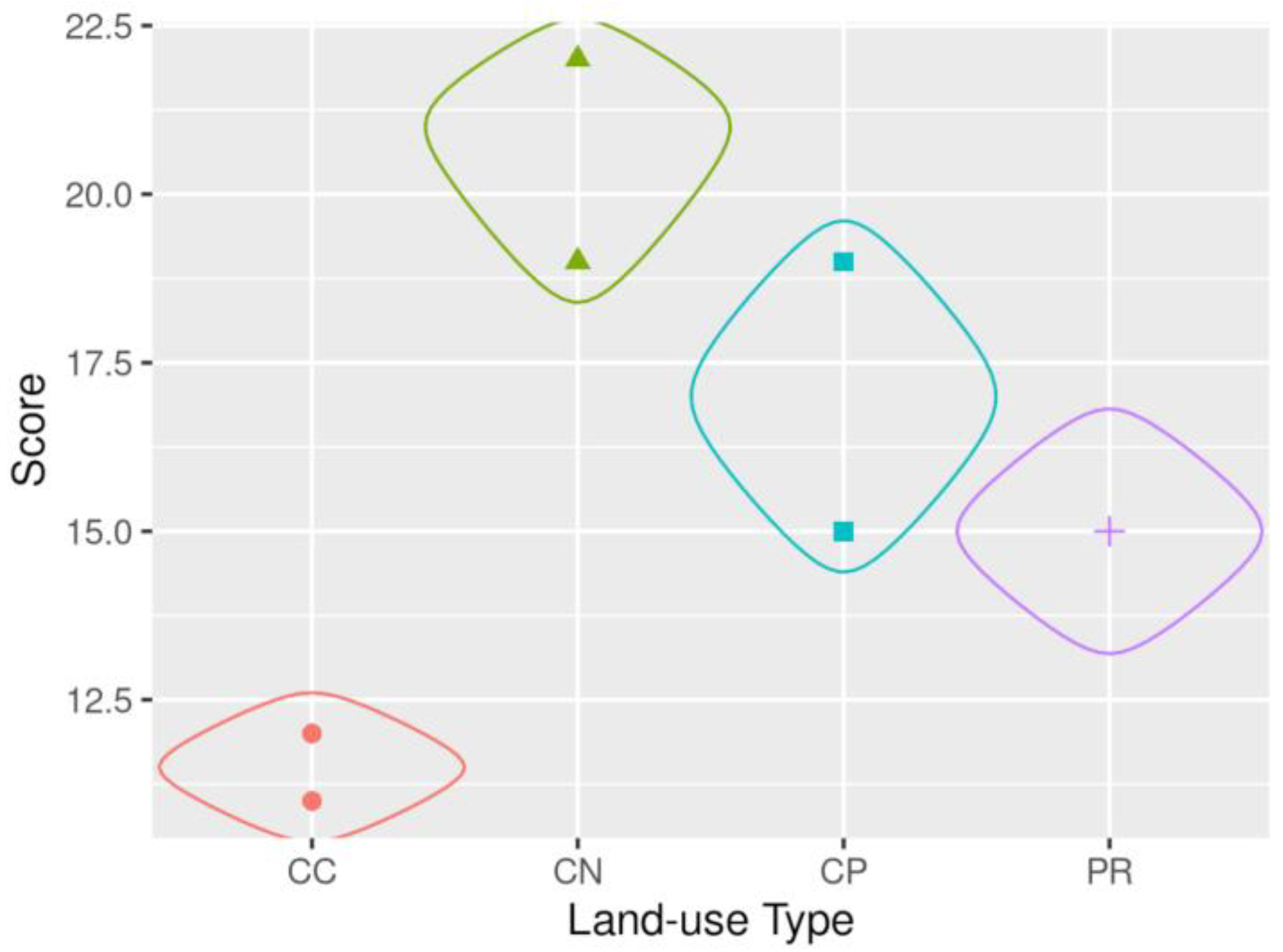
The results of the visual soil assessment are depicted in
Figure 6 and shown in detail in
Table 6. CN shows the highest scores (19, 22, and 22 points), followed by CP (19 and 15 points). The PR site scores 15 points twice and CC has the lowest scores (11 and 12 points). All plots, according to the three categories elaborated on (poor soil quality, moderate soil quality, and good soil quality) in the soil visual assessment, proposed by the Catholic Relief Services [
23], indicate a moderate soil condition. This means the plots score between 10 and 25 points after the evaluation using the corresponding table (
Figure A2) and the condition of the soil is assessed as moderate. If the soil scored under 10 points, it would be evaluated as negative soil conditions, and if the soil scored above 25 points, it would be categorized as positive soil conditions.
4. Discussion
The current study aims to use low-cost and easy to implement methodologies to assess the impact of shade-grown coffee agroecosystems on soil hydraulic conductivity over time. Evaluating the environmental impact of soil usage typically necessitates costly and time-consuming experimental efforts, limiting the possibility of estimating the physical and hydraulic properties of soil on a larger scale. Many coffee cooperatives and local research institutes, such as the cooperative Nuevo Sendero in Santa Rosa, Guatemala, lack access to demanding installations or expensive instrumentation. As a result, it is critical to estimate soil physical and hydraulic indicators using low-cost and simple to implement methods that provide a minimum degree of reliability to reach conclusions. Previous research in this area indicates that the SSBI methodology is a good compromise between measurement reliability, applicative simplicity, and the need for repeated sampling in space and time [
15,
18]. Furthermore, the soil visual soil analysis is even faster and cheaper to implement and can be used as a reference for soil quality in coffee plantations. During the study, we found a strong spatial variation among soil characteristics, even within the selected study sites. A large number of determinations is required to measure soil hydraulic properties properly and to assess the magnitude of the variation within the selected area. This finding thus confirms the need to find reliable methodologies to measure soil hydraulic properties that are not costly and time consuming to guarantee their on-field repeatability and feasibility. The methodologies chosen for this study proved to be relatively low cost and simple to implement for measuring soil hydraulic parameters and soil indicators. With a team of four people, one day of work was needed for each study site. All needed materials cost less than a total of USD 100, apart from the FieldScout Soil Sensor Reader (Spectrum Technologies), which costs around USD 400. This sensor, however, can be used repeatedly after a one-time purchase or rented from other research institutes or organizations.
While soils in the study area varied, this was overcome by selecting sites and landscape positions within the different land uses that have similar soil textural classes in the surface horizon. Due to the time and resource constraints of the research, it was not possible to include further treatments. However, we recommend that future studies include a larger number of treatments and replicates to ensure a more robust data set. A better understanding of the soils in the current area will aid in understanding the relationship between soil physical and hydrological characteristics.
Generally, soil attributes and Ks values show important differences between land-use types. Some differences in Ks values among specific land-cover types are not expected overall. Ks at the CP plantation is statistically lower than CC and PR. The lower Ks at CP does not support our study hypothesis that Ks average values would vary accordingly to the age of the trees in a land-use conversion from grassland to coffee agroforestry systems in time: CN > CP > CC = PR. Instead, the order is CN > CC = PR > CP. As expected, the highest Ks values are observed at the CN site, which also has greater values for the vegetation attributes (i.e., canopy cover, soil cover, vegetation height of tree, DBH, and the total number of trees). Higher Ks values for shade-grown coffee agroecosystems (older than 30 years) over pasture are also reported by Lozano -Baez et al. [
5] in the municipality of La Jagua de Ibirico, César department, Colombia, with predominant Entisols. They investigated the saturated hydraulic conductivity (Ks) and some hydrophysical soil attributes in four land-use types: shade-grown coffee; a natural regenerated forest 15 years ago; a pasture; and a reference forest. Their findings show that the Ks values for the coffee and the reference forest are comparable, indicating that trees have a positive effect on soil hydrological functioning in agroforestry systems. The study by Marín-Castro et al. [
43] shows that shade coffee plantations derived from tropical montane cloud forest can maintain a high capacity of soil hydraulic conductivity Ks, similar to that of the native forest. Tree species, particularly leguminous trees used in CN and CP (i.e.,
Inga fissiolyx), in association with coffee, can play an important role for soil water infiltration and support complementary water uptake [
5,
44,
45,
46]. Similarly, other authors report that soil compaction after forest conversion led to reduced Ks values and that intense agricultural use can cause a reduction in Ks in soil [
11,
47]. A systemic review of scientific literature investigating infiltration measurements in forests restored by tree planting in the subtropics and tropics conducted by Lozano-Baez et al. [
48] reveals that tree planting in forest restoration has positive effects on infiltration, supporting the higher Ks values found at CN.
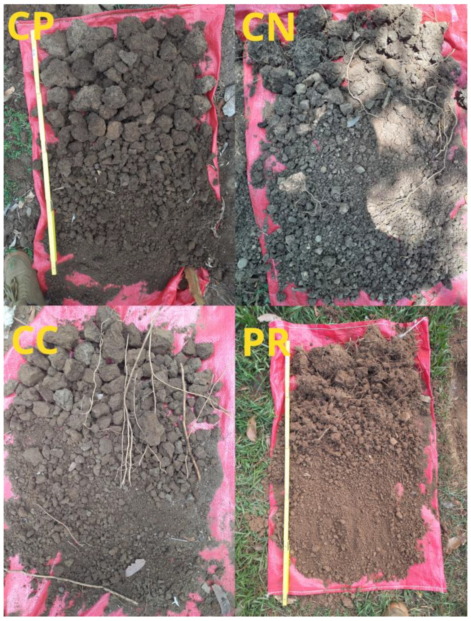
The CP site shows lower Ks values as expected. This result may be caused by the young age of the plantation. Prior investigations strengthen the position, that Ks full hydrological recovery of tropical degraded sites may take more than two decades. Ziegler et al. [
49] and Leite et al. [
27] suggest that a period of 25 years and 35 years could be enough to restore Ks values after soil degradation in Vietnam and in the Caatinga ecosystem respectively. Moreover, the profile from CP showed a very clear second horizon (at around 30 cm), where color and texture of the soil change drastically (
Figure 2). This is not observed on the other sites, were the color stayed constant along the soil horizons (until 70 to 100 cm). This very clear layer could influence the infiltration rate at the CP site. Generally, the PR and CC sites have high Ks values compared to other study sites with soils with similar textural class (sandy clay loam and sandy loam) [
22,
23]. This could be due to the land-use history of the sites, as both sites were used for non-commercial purposes. Thus, there was no intensive grazing management. The grazing management used by the landowners resembles more a rotational grazing management, which can improve soil degradation [
50]. Looking at the soil profile for PR, roots are present at a depth of 60 cm. In contrast, the CP site had no grazing management, and the potato and tobacco plantations could have had a more negative effect on the soil physic and hydrological properties than the non-commercial pastures management. Thus, it would be interesting for future studies to compare Ks values from the CP and PR sites with a land-use type based on other crops such as potato and sugar cane.
Looking more deeply into the study site CP, if plot 1 (CP1) from CP is excluded from the calculation of Ks for CP, Ks values at the plot 2 (CP2) in CP are statistically similar to CC and PR (
Table 5). The study site CP shows a high spatial variability of Ks values, and the greatest interquartile range and most extended whiskers of all study sites (
Figure 4). Furthermore, the mean Ks values between CP1 and CP2 are statistically significantly different (
Table 5). Both observations confirm a high spatial variability of soil hydrological characteristics within the study site CP, although both plots underwent similar land-use changes in the past decades. This shows the high spatial variability of soil characteristics and the importance of low-cost and easy to implement methodologies to cover increase repeatability in space and time of samples. Other study sites show no significant differences between mean Ks values between plots, indicating a more homogeneous distribution of soil physical and hydraulic characteristics.
The VWC values vary considerably between land-cover types. The statistically similar VWC values between the agroforestry coffee sites CP and CN, between the CN and PR land-use types, and the PR and CP sites, do not back up our initial hypothesis, mainly that the average VWC values would be ordered as follows: CN > CP > CC = PR. The actual result from the VWC average values is CP ≥ CN ≥ PR ≥ CC. Our initial hypothesis that TAL would vary at each site with different land-use type accordingly to canopy and soil cover (CC > PR > CP > CN), is not confirmed either. Instead, there is no significant difference between the mean TAL values for CC, PR, and CP, resulting in an average TAL value ordered as follows: CP = CN = PR > CN. Although we formulated these hypotheses based on findings from previous research on the influence of canopy cover, soil cover, and age of the plantation on microclimatic conditions of agroforestry systems, other investigations highlight the opposite, suggesting the importance to carry out further investigations in environments where little data are available.
The CN site has the lowest temperatures, below and above leaf litter, indicating that the higher canopy and soil cover impact greatly microclimatic conditions. Lin et al. [
1,
24] highlight the capacity of high shade cover (60–80%) coffee agroforestry systems to reduce overall evaporative demand, coffee transpiration, and contribute to the mitigation of variability in microclimate and soil moisture for the crop of interest. The high temperature difference between TAL and TBL for the CP site should not be left without attention. Although TAL is not significantly different between CP, CC, and PR, the CP site shows a taller boxplot, indicating a bigger spread of data. This could be due to the fact that the site has low canopy cover (20–30% shade), influencing the spatial variability of the temperature. Moreover, the high TD for CP indicates that leaf litter has a great positive influence on the soil temperature for young agroforestry systems.
Although CP has the highest VWC, it is not significantly higher than the values in CN. The study of Lin et al. [
1] outlines that lower shade cover (30–60% shade) could already contribute to maintain higher levels of soil moisture during the dry season. Additionally, Souza et al. [
51] argues that higher plant density and the presence of high trees, leads to a higher soil–water demand in forest and coffee sites, corroborating the slightly lower soil–water content in CN than CP. The study carried out by de Carvalho et al. [
28] shows lower soil moisture of shaded areas in contrast to the unshaded areas at different depths, which is also an indicator for improved deep water drainage, where trees in agroforestry systems reduce surface water losses. This research also explains that although water availability can be lower in the older shaded coffee systems during the dry season, such as in CP, it has no effect on coffee physiology because the coffee plant has neglected physiological growth development during this season.
The high TD values for CP show the importance of leaf litter for soil temperature, contributing to the maintenance of soil moisture. VWC was measured during morning hours, and dew was higher in the PR site due to higher temperature difference between night and day than in agroforestry systems. The study by Karki and Godman [
52] shows higher mean values for dew point in open pasture than in silvopastoral systems. Thus, morning dew could influence VWC values at the PR site. The low soil cover at the CC could explain the low VWC and the high soil temperature.
The values for the visual soil assessment (VSA) vary between plots and study sites. The hypothesis that the VSA would be ordered following the age of the agroforestry system: CN > CP > PR = CC, cannot be entirely confirmed. The study site PR shows higher results (twice 15 points) than the CC site (11 and 12 points). The repetitions for the soil visual assessment cannot be used for strong statistical statements, as there were too few repetitions. Nevertheless, it can be used as a reference to compare results and assess a visual soil assessment tool. The actual order for the scores for the VSA is CN > CP > PR > CC. All given scores group the state of the soil as moderate (scores between 10 and 25), according to the soil state classification proposed in the soil visual assessment tool developed by the CRS [
29]. The CN site scores the highest, reaching the upper scores for moderate soils, corroborating the results for Ks presented before. Soil structure, soil cover and soil depth are the most determining factors, as they have the highest influence on the total score. This contributes to the fact that PR scores better than CC, as CC has very low points for soil cover. It must be considered that the optimal time of the year proposed by the Catholic Relief Services to conduct the VSA is after the first rains. In Santa Rosa, Guatemala, this would be around the mid of Mai. Our study was conducted during the driest period of the year, at the end of the dry season (April). Thus, it must be considered that the soil VSA was carried out during a very dry period, and it should be repeated at different moments during the year (in
Table 6 almost every assessment scores zero for earthworms). The study sites score low for soil depth. This could be due to big rocks and very hard soils, which could be caused by the very dry season. Moreover, farmers and technical workers preferred the VSA methodology the most, making it a suitable methodology to be used by coffee farmers themselves.
According to multiple studies, shade trees in coffee agroecosystems can provide multiple benefits such as: (i) improve soil moisture retention and water infiltration [
44,
53,
54], (ii) regulate microclimate control [
1,
53,
55], (iii) regulate pests and diseases [
56,
57,
58,
59], (iv) provide a better quality of coffee beans [
43], (iv) help nutrient use efficiency [
60,
61,
62], (v) minimize erosion and landslide damage [
63,
64], and (vi) favor income stability [
60,
61,
62]. A high canopy cover in agroforestry coffee plantations, on the other hand, might decrease yield, resulting in a financial loss for coffee growers [
44]. Future studies assessing the advantages and disadvantages of shade-grown coffee in Santa Rosa department will therefore need to gather more empirical data.
The selected methodologies in this study have proven to be low cost and easy to implement, contributing to the development of soil assessment with restricted economic and time resources. This study was realized with low budget, reduced staff, and reduced time to implement the measurements. These conditions correspond to the reality of many research institutes in Guatemala and Latin America, making it vital to be able to carry out studies from this starting point to advance soil studies at local, national, and regional level. This study is a proof of its own applicability, as it was carried out with a very small budget and within a short period of time. In addition, we have managed to use methodologies that are simple and easy to understand for the farmers involved in this study, bringing the approach closer to day-to-day practice. The study participants are able to continue collecting data, contributing to the robustness of the study over time.
Other studies suggest that the SSBI methodology can be as robust as the BEST-steady method [
15,
17,
18,
22], making it a rapid, robust, and relatively inexpensive alternative to measuring soil hydraulic properties. Water infiltration techniques are easy to conduct and do not require intensive gears. Low-cost and rapid methodologies such as the ones presented in this study allow repeated measurements in time and space, strengthening the robustness of the data over time. Following the suggestions by Lozano et al. [
48], we recommend to monitor infiltration and other soil parameters in tropical and subtropical land-use systems at regular intervals to better understand the temporal variability of infiltration recovery and microclimatic parameters. Although we did not directly quantify variables such as soil macroporosity, soil biological activity, root biomass, plant diversity, organic matter, and topographic variations, these are widely regarded as primary drivers of Ks spatial variability in forest soils [
27,
48,
65,
66]. Further factors that contribute to differences in Ks include past land-use intensity as well as spatial and topographic variations in soil depths along the toposequences [
22]. Therefore, given the importance of the above mentioned factors, future research may investigate how to integrate low-cost and easy to implement methodologies to assess these factors in tropical and subtropical land-use systems.
5. Conclusions
This study supports the findings that agroforestry systems, such as shade-grown coffee, benefit the hydrophysical soil properties and micro-climatic conditions. The comparative analysis of Ks in coffee agroforestry systems older than 30 years (CN), coffee agroecosystem of seven years (CP), newly planted shade-grown coffee (CP), and non-commercial pasture (PR) show higher Ks values for CN. Comparison with prior studies shows that a period of seven years is too short to see a significant recovery of Ks.
Our study concludes that in seven-year-old coffee agroforestry systems, leaf litter can already improve soil moisture retention through climatic regulation. The soil visual assessment proposed by the Catholic Relief Services for coffee soils in Central America corroborates the presented results, showing the highest scores for CN followed by CP. The methodologies selected for this study were selected considering two main factors: affordability and reproducibility. The simplified method based on a Beerkan Infiltration run (SSBI method), the temperature measurements with an infrared thermometer, the use of a time-domain reflectometry sensor, and the soil visual assessment tool proposed by the Catholic Relief Services prove to be efficient, low cost, and easy to implement.
It must be noted that the available scientific evidence in this area is severely limited and that the use of rapid and inexpensive methodologies may have constraints that should be considered in future research: (1) The effect that plant species, diversity of plants, or tree densities could have on infiltration should be comprehensively considered in future research. (2) The scarcity of long-term studies using similar low-cost methodologies in the area is very limited. When the results of short-term experiments are extrapolated to long-term evaluations, this can be problematic and misleading. To better comprehend the temporal variability of infiltration recovery, we suggest monitoring infiltration in tropical land-use systems at set intervals. (3) The interactions between infiltration and other soil properties are extremely complex and remain poorly studied. More experiments in tropical agroforestry systems should be conducted, considering soil structure and the influence of microporosity and soil biological activity on infiltration. (4) Other factors influencing Ks, such as plant diversity, organic matter, topographic variations, and land-use history, should be considered more in detail to assess the differences in hydrological properties of different land-use systems.


 ,
, 

