Article

Pedogenesis of Fluvial Terrace Soils Related to Geomorphic Processes in Central Taiwan

1
Center of General Education, National Chungcheng University, Chiayi 62102, Taiwan
2
Department of Geography, National Changhua University of Education, Changhua 50058, Taiwan
3
Department of Agricultural Chemistry, National Taiwan University, Taipei 10617, Taiwan
4
Department of Science Education and Application, National Taichung University of Education, Taichung 40306, Taiwan
*
Author to whom correspondence should be addressed.
Land 2023, 12(3), 535; https://doi.org/10.3390/land12030535
Submission received: 27 December 2022 / Revised: 9 February 2023 / Accepted: 20 February 2023 / Published: 22 February 2023

Abstract

:
Pedogenetic features of the soils could be a proxy for revealing the landform surface processes. Our work first analyzed the particle size distributions and lithological discontinuities (LDs) of the soils in the midstream of the Zoushui River, central Taiwan. The results showed that the parental materials of the soils derive from mixed sediments of the Zoushui River and its tributaries, and the LDs of some soils suggested multi-depositional events with homogeneous lithology. Then, we proposed a soil chronosequence of Inceptisols, Ultisols, and Oxisols, over the Pleistocene timescale. There was a very well-defined semilogarithmic relationship between weighted profile development index (WPDI) values and soil age with correlation coefficients (r) greater than 0.9. The age of the soils did not certainly agree with the interglacials of the main marine isotope stage (MIS). However, the soils started to develop only after being aggraded by relatively warm and humid periods or by extreme rain events in cool and dry periods. Irrespective of whether the soils had started to develop, tectonic downcutting, providing clear altitudinal separation of the terrace treads, could inevitably happen later (or almost synchronologically) to ensure stabilities of the tread surfaces.

1. Introduction

The pedogenetic features of soil are related to the history of landform surface processes [1,2]. The soil chronosequence is thought to be a useful framework for gauging the relationships between pedogenesis and landform surface processes. A soil chronosequence is a suite of soils whose properties change over time under similar vegetation, topography, climate, and lithology conditions [1,3,4]. The soil chronosequence, which reveals the rates and directions of pedogenic change, is a valuable indicator for testing pedogenic theories [1,4,5]. For example, the soil chronosequence is used for gauging chronologically progressive or regressive developments of soil properties and the developments that reach a steady state or rarely reach a kind of near steady state [1,5,6,7]. Soil chronosequences also show that the genetic pathways of soils under varied climatic conditions are required for the evolution of a specific kind of soil [1,8,9,10].
Moreover, the soil chronosequence is thought to be an elementary issue of soil geomorphology [1], because the formative history of a continuum soil within the landscape directly relates to the landform surface processes [2,11]. The soil chronosequence shows that changes in pedogenic features on the landform surface over time could be an alternative solution for revealing geomorphic history that lacks dating data [1,12,13]. Several studies have proven the application of alternative solutions, such as postglacial landform evolutions in southern European alpines related to climatic shifts since the late Pleistocene [14,15], the relevance of soil distributions within a landscape to landform types and processes [16,17], pedostratigraphic relations of marine terraces [18,19,20], and the correlation of river terraces with lateritic soils that were uplifted and deformed by tectonic events [17,21,22].
Theoretical chronologic pathways have been proposed [1,10]; however, soil chronosequences in the tropical Western Pacific region, which are less understood and have different lithological conditions, have suggested the divergence of the pedogenic pathway. For example, soil chronosequences on fluvial terraces in central Taiwan suggest a pedogenic pathway from Entisols and Inceptisols to Ultisols within a period of thousands to tens of thousands of years [17,19,23], whereas another similar pedogenic pathway was proposed by Jien et al. [24] on the marine terraces on Green Island, eastern Taiwan. Two forest soils in Leyte, Philippines, which have developed from Quaternary and Pleistocene to Pliocene volcanoclastics, show a chronosequence from Andosol to Alisol [25]. Moreover, a pedogenic pathway from Entisols, Mollisols, Vertisols, and Alfisols has been constructed on the Holocene marine terraces in eastern Taiwan [26] as well as on the late-Pleistocene marine terraces of Kikai Island, Japan [27]. In addition, a very long period of soil chronosequences on Hainan Island, China, consisting of six profiles with ages ranging from 10 to 1800 ky, were formed on basalt. This revealed that kaolinite minerals were the main clay minerals, and gibbsite was enriched in the C-horizon of the older soils [28]. Furthermore, Pillans [29] showed a very slow developmental soil chronosequence forming on basalt of more than 1 Ma in northern Australia. The time required for forming a specific type of soil has provoked much controversy among studies.
A tropical river terrace soil chronosequence midstream of the Zoushui River in central Taiwan was constructed and used as a relative dating proxy for gauging the evolution of river terraces related to tectonic uplifts [17,21,23]. However, the period required for forming specific soils in this soil chronosequence is still debated because of the lack of dating ages [17], and no consensus on the geomorphic history of these terraces has been reached by various researchers [21,30,31,32]. Therefore, soils on the terraces that have not been studied by Tsai et al. [21,23] along the middle reaches of the Zoushui River are worthy of sampling and revealing the chronology of pedogenic features. It also helps increase the understanding of the soil chronosequence in the tropical Western Pacific region. In addition, based on geomorphic characteristics, paleoclimatic fluctuations [33], and dating ages [32], the soil chronosequence in the midstream of the Zoushui River has been influenced by geomorphic processes since the late Pleistocene. The aims of the study were (1) to present the chronological pedogenic pathway of soils in central Taiwan and (2) to gauge the required time for forming specific soils and relate pedogenic features to paleogeomorphic processes.

2. Materials and Methods

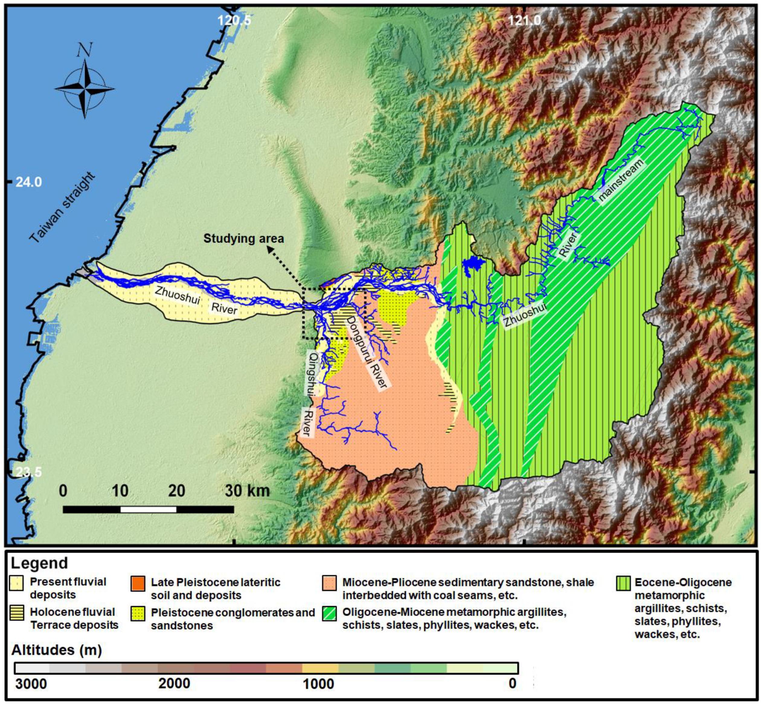
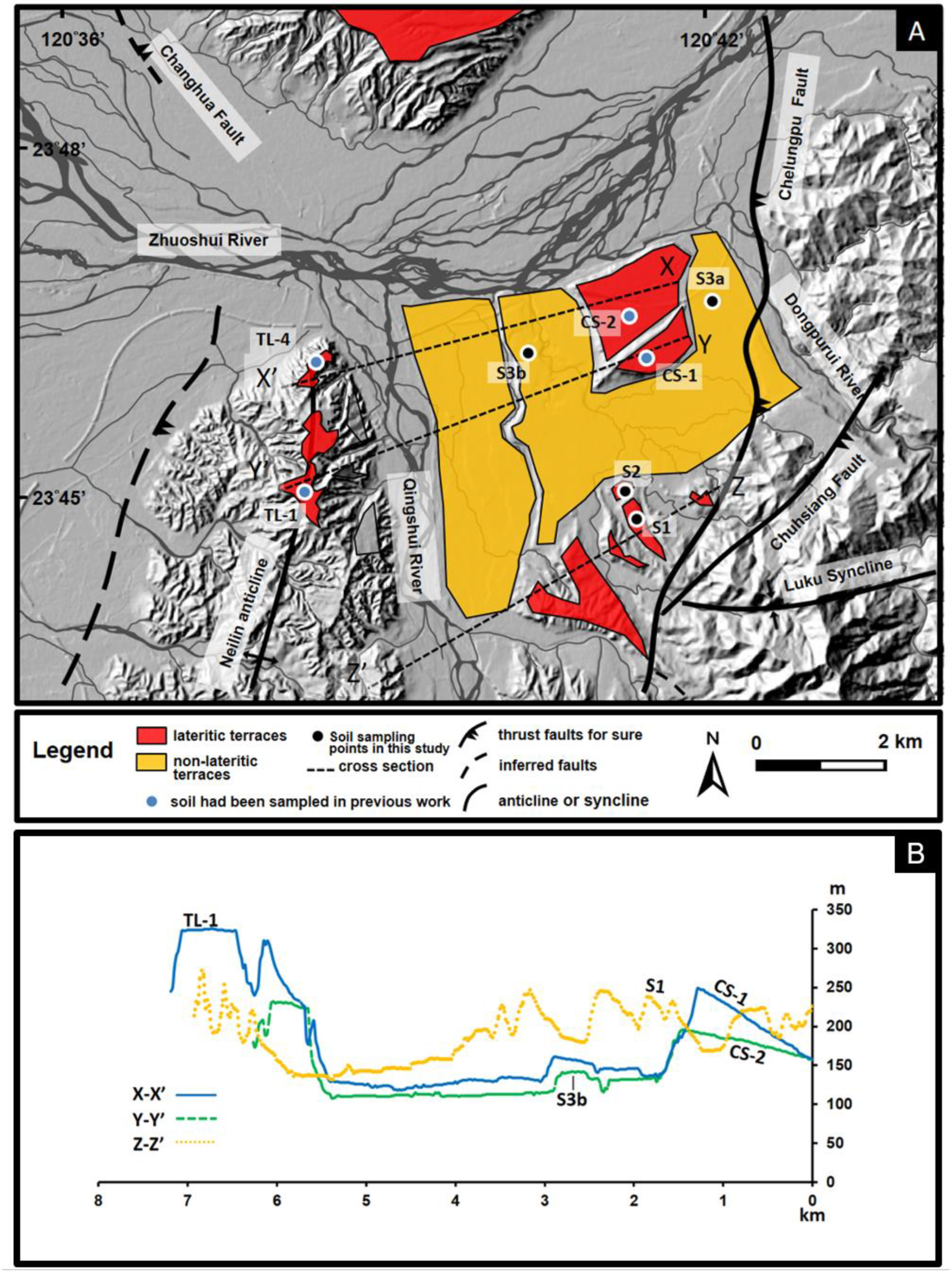
2.1. Geological Setting

Because of the convergence of the Philippine Sea Plate and the continental margin of the Eurasian Plate with a high shortening rate of approximately 7–8 cm per year [34,35], the latest orogenic movement in Taiwan has caused continued crustal deformation characteristics. The active tectonics not only cause the gradient of rock metamorphism to be high in the eastern part of Taiwan and slight or none in the western part (Figure 1), but also induce wide distributions of tableland-like terraces in Taiwan [36].
Tectonic compression induced two major active thrust faults in the mid-reaches of the Zoushui River, the Changhua and Chelungpu faults (Figure 2). The movements of the Changhua fault formed fault-bend folds and easterly tilted lateritic terraces (LT) (Figure 2) [21]. The latest displacement of the Chelungpu Fault caused the largest inland earthquake in the 20th century in Taiwan [37,38]. However, no evidence shows that the LT terraces in the middle reaches of the Zoushui River were deformed by the Chelungpu fault. Several fluvial terrace treads have been deposited and incised by the Zoushui River and its tributaries, the Qingshui River, and the Dongpurui River since the late Pleistocene in central Taiwan (Figure 2). However, only a few 14C dating ages have been determined for specific terraces [30].
The Zoushui River, the longest river in Taiwan, flows through metamorphic rocks (e.g., argillite, schist, slate, and phyllite) upstream and sedimentary rocks (e.g., sandstone, shale, and conglomerate) midstream (Figure 1). The mineralogical compositions of deposits by the mainstream upstream and by the tributaries from the midstream (e.g., Qingshui River and Dongpurui River in Figure 1) are quite different. The deposits upstream of the mainstream contain many slate fragments and debris. In contrast, the deposits by tributaries in the midstream contain sandstone or shale fragments with quartz grains [38]. Therefore, the percentage of quartz and slate fragments in sand-sized particles of the sediments and soils on the river terraces was used as an indicator of the parental origins of sediments and soils on the river terraces [39].
The mean monthly temperature of the study area varies from 28 °C in July to 19.8 °C in January, and mean annual temperature was 25 °C. The mean annual precipitation is approximately 1700 mm. The study area is characterized by a tropical monsoon climate. This climate condition suggests an udic soil moisture regime and hyperthermic soil temperature regime [40].

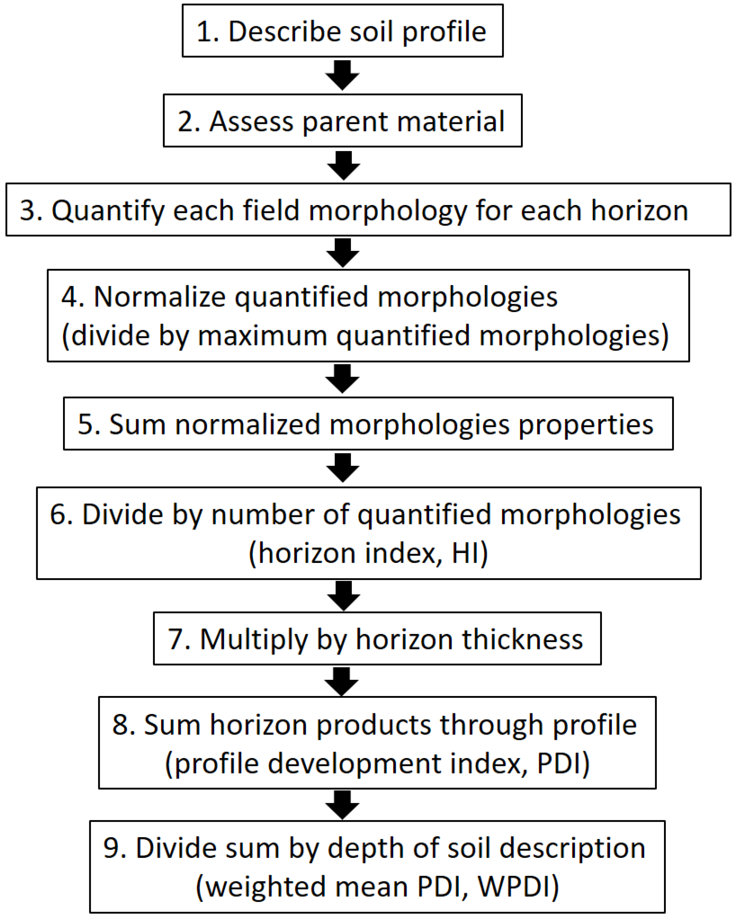
2.2. Soil Sampling, Morphological Descriptions, and Soil Development Index

To reveal the pedogenic features of the soils on the terraces and gauge the relationships between pedogenic features and geomorphic evolution of the terraces in the study area, we carefully selected one sampling site on each terrace, with fewer artificially modified sampling sites and well-preserved soil profiles. We sampled four terrace soils, named S1, S2, S3a, and S3b. The soil locations are shown as black dots in Figure 2. After sampling, the soils were air-dried and sieved (<2 mm) for further analysis. In addition, four other soils, named TL-1, TL-4, CS-1, and CS-2 (blue dots in Figure 2), were sampled, and their physicochemical properties were analyzed to correlate the lateritic terraces in our previous work [21,23]. We also used these abbreviations as the names of the terraces. Furthermore, we used these eight soils together to calculate the soil development index (SDI), determine the amounts of slate and quartz in sand-size fraction particles, and calculate indices of lithological discontinuity in this study. Table 1 lists the basic information about the eight studied soils related to geomorphic features.
The studied soils were described by morphological features based on the soil survey manual [41]. The horizon index (HI) and weighted mean profile development index (WPDI), proposed by Harden [3], were subsequently modified by Birkeland [1] and Tsai et al. [17]. Quantified soil morphologies have been used to easily compare developmental degrees between varied soils with different parent materials under different climatic regimes [42]. This study calculated HIs and WPDIs based on soil morphology, including color (moist and dry conditions), texture, structure, consistency, and clay coating. The pH and organic matter content of the soils used in the original method were excluded from the calculation because the pH and organic matter of soils for more than ten thousand years have reached a relatively steady state compared with other soil properties [1,17]. Moreover, the lower organic matter content in our soils was related to an indistinctive variation in the color value (lightening and darkening); thus, it was excluded from the calculation. Table 2 and Figure 3 present the calculation methods for the HI and WPDI.

2.3. Laboratory Analyses

A 35% hydrogen peroxide solution and the dithionite citrate bicarbonate (DCB) method [43] were used for removing organic matter and Fe-oxides from the soils, respectively. The particle-size distributions of the soils were determined using the pipette method [44]. Furthermore, the soil sand particle size fractions were collected and oven-dried (105 °C). The sand particle size fractions were then sieved into 5 particle grades: very coarse (2–1 mm), coarse (1–0.5 mm), medium (0.5–0.25 mm), fine (0.25–0.1 mm), and very fine (0.1–0.05 mm).
The very coarse, coarse, and medium particle size fractions were easily identified in the morphologic characteristics of rock fragments with a low-power microscope. These three grading particles were collected to subsequently determine amounts of slate fragments for assessing the origins of the sediments and soils in the Zoushui River basin. Therefore, we classified these particles into slate, quartz, and other rock fragments. Figure 4 shows the photos of quartz, slate, and other rock fragments taken with the low-power microscope. The morphologic characteristics of quartz particles were transparent grains with a glassy luster, no cleavage plane, and conchoidal fractures. In contrast, the slate particles showed black or greenish-black grains with a silky luster and schistosity. Thus, the other rock fragments have no quartz or slate features. Finally, we counted each grain as one point (point-counting method) to determine the number and proportions of these three groups. We counted each grain as one point.

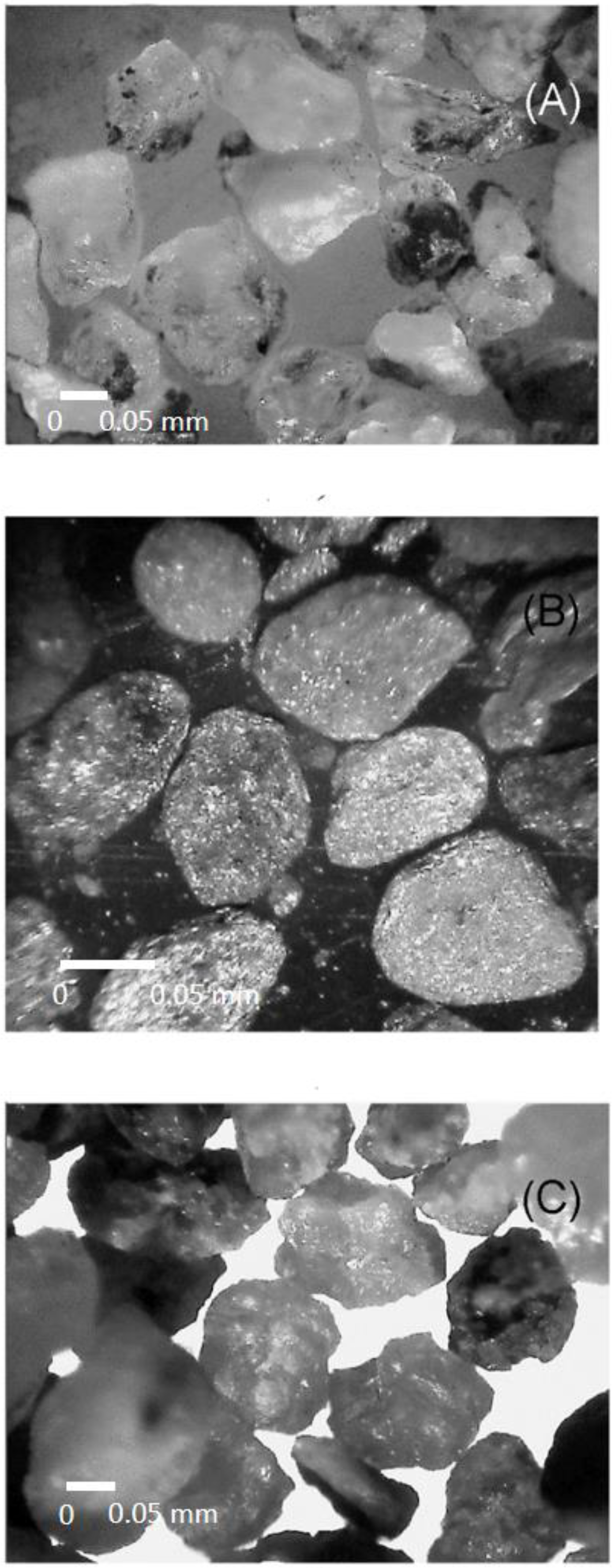
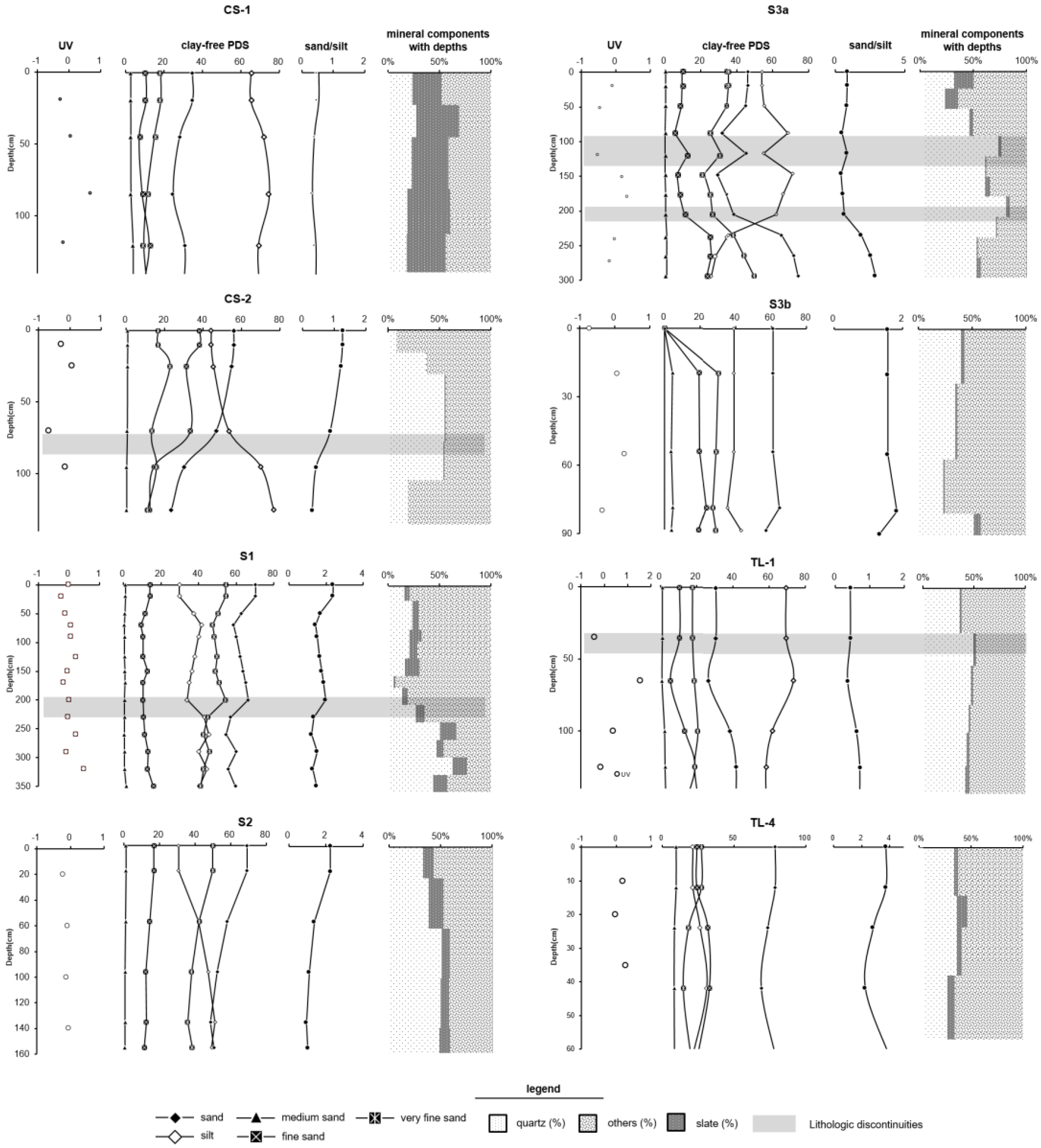
2.4. Indices of Lithological Discontinuity

Lithological discontinuities (LDs) are detectable changes in the vertical direction of a soil profile [45,46,47]. The presence or absence of LDs in a soil profile is useful for identifying disconformities in the parent material’s variable particle size or mineralogy, caused by stratification in the parent rock or by fluvial, colluvial, or aeolian additions [44,45,47,48]. Thus, besides the mineralogical components in sand-sized particles of the soils showing the parental origins, LDs could be a proxy to explore the origin of soils on terraces related to fluvial history.
Several soil properties are thought to be useful indices for identifying LDs, such as clay-free particle size distributions (CF-PSD, including clay-free sand, silt, medium sand, and fine sand particles), sand/silt ratio, and uniformity value (UV) [48,49,50]. These properties were used in this study. UV was calculated based on Cremeens and Mokma [50].
UV = % s i l t + % v e r y   f i n e   s a n d / % s a n d % v e r y   f i n e   s a n d i n   u p p e r   h o r i z o n % s i l t + % v e r y   f i n e   s a n d / % s a n d % v e r y   f i n e   s a n d i n   l o w e r   h o r i z o n 1
The greater the deviation of the uniformity value from zero, the greater the possibility of originally non-uniform parent materials. Schaetzl [48] and Tsai and Chen [49] suggested that ±0.6 was the proper value to identify the depth of the LDs. Therefore, in this study, a ±0.6 UV value was used to identify the LDs of all soils.

3. Results and Discussions

3.1. Soil Morphologies

The morphologies of CS-1, CS-2, TL-1, and TL-4 were described in our previous work [21]. The morphologies of S1, S2, S3a, and S3b are presented below:
The morphologies of the four soils suggested that S1 and S2 soils had higher degrees of development than S3a and S3b soils. The topsoils of S1 and S2 soils had morphological features such as yellowish-brown or olive-brown color, sandy loam texture, angular blocky or granular structures, friable in moist and slightly hard in dry consistency, slight or no stickiness, and slight plasticity in wet consistency, which meet the criteria of the ochric horizon [40] (Table 3). The subsoils of S1 and S2 were slightly rubified, had a strong brown color (7.5YR in hue), and had moderately to strongly subangular blocky structures, a sticky and very plastic wet consistency, a finer texture than topsoil, and a few faint clay films coating the lining pores. Subsoils S1 and S2 met the criteria for the argillic horizon [40] (Table 3). The S3a and S3b soils were less rubified and had moderately subangular blocks, a friable to firm moist consistency, a slight sticky or sticky consistency, and a slight plastic or plastic wet consistency. The topsoils of S3a and S3b were the ochric horizon, whereas the subsoils agreed with the criteria for a cambic horizon [40].
Based on their morphologies, the S1 and S2 soils were classified as Ultisols in Soil Taxonomy [40]. S3a and S3b soils were classified as Inceptisols in the Soil Taxonomy [40] (Table 1).

3.2. Particle Size Distributions, LDs, and Rock Fragments

The particle size distributions of CS-1, CS-2, TL-1, and TL-4 were reported in our previous work [21]. We determined the particle size distributions of S1, S2, S3a, and S3b soils (Table 4). The particle size distributions of the soils suggested that most soils had a coarse texture, with sand-size fractions of approximately 30–50% and more than 60% of sands (Table 4). Moreover, the clay distributions with depth indicated that clay was illuviated in the subsoils of the S1 and S2 soils, which met the criteria of the argillic horizon in the Soil Taxonomy [40], but the enrichment of clay in the subsoil of the S3a soils was attributed to multi-depositions or paddy cultivation (Table 4).
Furthermore, we calculated LDs indices for the eight soils. Figure 5 shows the depth distributions of the UV value, CF-PDs, clay-free sand/silt ratio, and mineralogical compositions of sand-size fractions for the soils. No distinct LD was identified based on UV values (variations less than ± 0.6), vertical consistency of CF-PDs, or clay-free sand/silt ratio in the CS-1, S2, S3b, and TL-4 soils (Figure 5). This suggested that the four soils were homogeneous. In contrast, vertical changes in the UV value, CF-PDs, and clay-free sand/silt ratios showed one or two LDs in CS-2, S1, S3a, and TL-1 soils (Figure 5).
Almost all soils contained varying amounts of slate fragments, such as the CS-1 soil, which had approximately 30–40% slate fragments, whereas the other soils contained approximately 1–20% (Table 4 and Figure 5). This suggests that the parent materials of the soils were derived from the cofluent sediments of the Zoushui River and its tributaries, the Dongpurui River, and the Qingshui River. This result further confirmed that the river terraces were formed by the Zoushui River and its tributaries [30].
LDs, the detectable changes in the vertical direction of a soil profile, originate from multi-depositional events with homogeneous lithology or varied parental materials from various sources [48,49]. The LDs could be difficult to identify from field morphologies because the pedogenic processes modified or erased features of the LDs [48], but they are easier to detect from some quantified parameters based on clay-free particle size distributions [48,49]. Our study suggested that the mineralogical compositions of the soils on the terraces were similar, whereas the LDs of the soils were attributed to multi-depositions by the Zoushui River and the tributaries before the fluvial terraces were abandoned by the river channels.

3.3. Pedogenic Correlations of the Soils

HI and WPDI values are indices for quantifying the degree of soil development [1,3]. Several studies have suggested that the HI and WPDI values of soils on the Quaternary terraces within the basin are good proxies for correlating terraces without aging and gauging scenarios of geomorphic evolution [17,21,22,51,52,53,54].
We used the HI and WPDI values of all soils in the study area for pedogenic correlations to determine the relative chronological order of soils. The HI and WPDI values of all soils are shown in Table 3 and Figure 6. The results showed that CS-1 and TL-1 had higher HI and WPDI values than other soils. The HI and WPDI values of the CS-2, S1, and S2 soils were similar, but those of S1 were slightly higher than those of the other two soils. Furthermore, by referring to the geomorphic features of the terraces where the soils were sampled, such as the difference in elevation, continuity of terrace treads, and dipping of the tilted terrace, we suggest that the ages of the CS-1, S1, and TL-1 soils were similar, whereas the CS-2 and S2 soils formed later in the same period.
S3a showed relatively higher HI and WPDI values than S3b and TL-4 soils due to anthropogenic disturbance. It is noticed that the S3a and S3b soils were perennially cultivated for rice for at least more than one hundred years [55]. Soil planted with rice for a long period was named paddy soil. Paddy soil is characterized by redoximorphic features, high silt content, bulk density, and hardness in dry consistency throughout the profile [56,57]. Similar morphologies were identified in the S3a and S3b soils, such as iron-oxide mottling through the profile, a very hard, dry consistency, and more than 50% silt content in the subsoil (Table 4). These morphologies yielded more points when quantifying the HI and WPDI values. Thus, the HI and WPDI values of S3a and S3b soils were not suitable for constructing a soil chronosequence. These two soils were excluded from the following discussions about the soil chronosequence. However, we further considered the geomorphic features and soil properties of all soils. We suggest that the ages of the S3a and S3b soils could be correlated to TL-4.

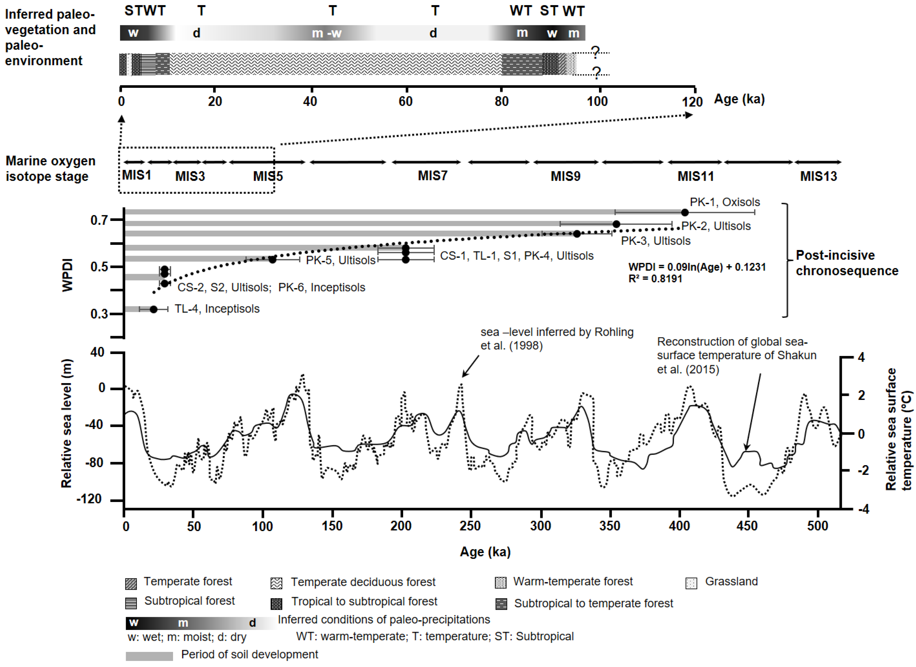
3.4. Further Implications for Soil Chronosequence Related to Paleo-Environments

A nearby soil chronosequence, in which the pedogenic pathway was from Inceptisols, Ultisols, and Oxisols, on the Pakua terraces in the midstream of the Zoushui River, was proposed by Tsai et al. [22] and Tsai et al. [23], whereas the absolute ages of the soil chronosequence were still under debate. Siame et al. [33] proposed a chronological framework of Pleistocene alluvial deposits for Pakua terraces using the 10Be cosmogenic dating method. The dating dates of the Pakua terraces provided more precise chronological constraints for constructing a soil chronosequence. Thus, we assigned the PK soils to given ages of terraces from the literature [22,33] and then correlated the soils in the study to the soils on the Pakua terraces based on HI as well as WPDI values. The soil ages in this study were then estimated.
A soil chronosequence of Inceptisols, Ultisols, and Oxisols over the Pleistocene timescale is proposed in this study (Figure 7). The soil chronosequence suggests that Inceptisols, Ultisols, and Oxisols require thousands, tens to several hundred thousand, and more than four hundred thousand years to form, respectively. Some soil chronosequences have been proposed under climatic conditions similar to those in Taiwan in the western Pacific regions. He et al. [28] suggested a soil chronosequence: Inceptisols (90–150 ka), Alfisols (640–1330 ka), and Oxisols (1810 ka). Another similar chronosequence was recently proposed by Huang et al. [58] and Li et al. [59]. Both soil chronosequences were found on Hainan Island, China, and their parental material was weathered basalt. In addition, Nagatsuka and Maejima [27] proposed a soil chronosequence, Mollisols (15–75 ka) and Alfisols (125–224 ka), on the marine terraces of Kikai Island, Ryukyu, Japan, whose parental materials are limestone. Moreover, Tsai et al. [60] and Huang et al. [26] constructed a marine terrace soil chronosequence of Entisols (<3 ka), Mollisols (3–7 ka), and Vertisols (>7 ka) in eastern Taiwan, and its parental materials were andesitic and volcanic fragments. Although the effect of parental materials on the soils would fade with time based on pedogenesis theory [45], our case indicated that even under similar climatic conditions, the discrepancy of parental materials still has a vital influence on soil properties over tens to hundreds of thousands of years.
Furthermore, dating or extrapolating ages were used for the terrace deposits instead of directly for the soils in the study area [30,33]. These ages could be considered the maximum age of the soil because the soil started to form after the terrace was abandoned by the stream channel [1,61]. Thus, we used WPDI values to construct a chronofunction for the soils. The results showed a very good relationship between WPDI values and soil age (Figure 7), with correlation coefficients (r) exceeding 0.9. A single-logarithmic relationship with age was suggested, which agreed with the function types proposed by Bockheim [6]. The pedogenesis of the soil has not yet reached a steady state.
Siame et al. [33] suggested that the ages of the Pleistocene terraces with lateritic soils in central Taiwan could be related to marine isotope stages (MIS). Figure 7 shows the relationship between the age of the soils and the time of the main MIS. This indicates that the ages of all soils did not exactly agree with the interglacials of the MIS, which are characterized by high sea levels and relatively warm temperatures. Instead, the ages of the soils agreed with those of the glacials of the MIS, such as PK-2, CS-2, S2, and TL-4 (Figure 7). Liew et al. [32] proposed detailed paleoclimatic changes based on the pollen stratigraphy record in central Taiwan since the last interglacial period of MIS 5 (Figure 6). Previous studies on the Late Pleistocene mass-wasting histories and river terraces within the basin of the Zoushui River have shown that the formative ages of the terraces may not agree with the interglacials of the main MIS [62,63]. Moreover, the thick alluvium of the terraces formed during the glacial period was triggered by heavy rain events that provided depositional loads [62,63]. Thus, although CS-2, S2, and TL-4 soils were in periods of relatively dry and cool climates (Figure 7), their formative histories could be related to some heavy rain events in the glacial stage.
We propose a scenario for soil-geomorphic interactions. Irrespective of the development of the soils, heavy rain events in either the interglacials or glacials provided sediment loads. Tectonic downcutting provided a clear altitudinal separation of the terrace treads. Relatively stable terrace treads facilitated the subsequent development of soils. These tectonic activities should be regarded as synchronically occurring; otherwise, other aggradation events would cover the soils and paleosoils, as well as multipedostratigraphies. The identification of one or two LDs in some soils indicated that repeated flooding occurred in a very short period.
Figure 7. Conceptual schematic diagram of soil pedogenesis related to paleoclimatic variations since MIS 11. Global mean sea level shifts were inferred by Rohling et al. [64]. Reconstruction of global mean sea-surface temperature was suggested by Shakun et al. [65]. Inferred conditions of paleovegetation and paleoenvironment were proposed by Liew et al. [32], which based on a pollen record from peat sediments in central Taiwan. WPDI values of PK−1~PK6, CS−1, CS−2, TL−1, and TL4 were calculated by Tsai et al. [23].
Land 12 00535 g007

4. Conclusions

The studied soils on the river terraces in the midstream of the Zoushui River, central Taiwan, show that more rubification, stronger structures, and clay coatings were identified in the old soils than in the young. No distinct LD was identified in CS-1, S2, S3b, and TL-4 soils. One or two LDs were identified in CS-2, S1, S3a, and TL-1 soils. Almost all of the soils contained varying amounts of slate fragments. This suggests that the parent materials of the soils were derived from the sediments of the Zoushui River and its tributaries. The LDs, which are detectable changes in the vertical direction of a soil profile, originate from multi-depositional events with homogeneous lithology. This suggests that the terraces where the soils overlie are cofluvial with the Zoushui River and its tributaries.
A post-incisive soil chronosequence for Inceptisols, Ultisols, and Oxisols over the Pleistocene timescale is proposed. WPDI values and soil ages showed a semi-logarithmic relationship, with a correlation coefficient (r) of approximately 0.9. This means that more than ten thousand years are required to form Ultisols, whereas the time required to form Oxisols is about 400 thousand years.
Irrespective of whether the soils had started to form since the glacial or interglacial periods, the incipient development of the soils was triggered by heavy rain events and by tectonic downcutting. The former provided thick sediments as parental materials, whereas the latter provided clear altitudinal separation of the terrace treads to ensure the stability of the tread surfaces, which facilitated subsequent development of the soils.

Author Contributions

Conceptualization, W.-S.H. and H.T.; Formal analysis, W.-S.H. and C.-S.L.; Funding acquisition, H.T.; Investigation, W.-S.H., C.-S.L., H.T. and S.-T.H.; Methodology, Z.-Y.H.; Resources, Z.-Y.H.; Writing—original draft, W.-S.H. and C.-S.L.; Writing—review & editing, H.T., Z.-Y.H. and S.-T.H. All authors have read and agreed to the published version of the manuscript.

Funding

This research was funded by the Ministry of Science and Technology, ROC, Taiwan, Contract No. MOST 111-2116-M-018-002.

Data Availability Statement

The authors declare that the data supporting the findings of this study are available within the paper.

Conflicts of Interest

We declare that we have no financial and personal relationships with other people or organizations that could inappropriately influence (bias) their work or state.

References

  1. Birkeland, P. Soil and Geomorphology; Oxford University Press: Oxford, UK, 1999. [Google Scholar]
  2. McFadden, L.D.; Knuepfer, P.L.K. Soil geomorphology: The linkage of pedology and surficial processes. Geomorphology 1990, 3, 197–205. [Google Scholar] [CrossRef]
  3. Harden, J.W. A quantitative index of soil development from field descriptions: Examples from a chronosequence in central California. Geoderma 1982, 28, 1–28. [Google Scholar] [CrossRef]
  4. Huggett, R.J. Soil chronosequences, soil development, and soil Evolution: A critical review. Catena 1998, 32, 155–172. [Google Scholar] [CrossRef]
  5. Sauer, D. Pedological concepts to be considered in soil chronosequence studies. Soil Res. 2015, 53, 577–591. [Google Scholar] [CrossRef]
  6. Bockheim, J.G. Solution and use of chronfunctions in studying soil development. Geoderma 1980, 24, 71–85. [Google Scholar] [CrossRef]
  7. Phillips, J.D. The robustness of chronosequences. Ecol. Modell. 2015, 298, 16–23. [Google Scholar] [CrossRef]
  8. Bockheim, J.G.; Gennadiyev, A.N.; Hammer, R.D.; Tandarich, J.P. Historical development of key concepts in pedology. Geoderma 2005, 124, 23–36. [Google Scholar] [CrossRef]
  9. Schaetzl, R.J.; Barrett, L.R.; Winkler, J.A. Choosing models for soil chronofunctions and fitting them to data. Eur. J. Soil Sci. 1994, 45, 219–232. [Google Scholar] [CrossRef]
  10. Lin, H. Three Principles of soil change and pedogenesis in time and space. Soil Sci. Soc. Am. J. 2011, 75, 2049–2070. [Google Scholar] [CrossRef] [Green Version]
  11. Birkeland, P.W. Soil-geomorphic research—A selective overview. Geomorphology 1990, 3, 207–224. [Google Scholar] [CrossRef]
  12. Schaetzl, R.J.; Lansing, E.; Mikesell, L.R.; Velbel, M.A. Soil characteristics related to weathering and pedogenesis across a geomorphic surface of uniform age in Michigan. Phys. Geogr. 2006, 27, 170–188. [Google Scholar] [CrossRef]
  13. Wysocki, D.A.; Schoeneberger, P.J.; Hirmas, D.R.; LaGarry, H.E. Geomorphology of soil landscapes. In Handbook of Soil Sciences: Properties and Processes, 2nd ed.; Huang, P.M., Li, Y., Sumner, M.E., Eds.; CRC Press: Boca Raton, FL, USA, 2012; pp. 29.1–29.26. [Google Scholar]
  14. D’Amico, M.E.; Pintaldi, E.; Catoni, M.; Freppaz, M.; Bonifacio, E. Pleistocene periglacial imprinting on polygenetic soils and paleosols in the SW Italian Alps. Catena 2019, 174, 269–284. [Google Scholar] [CrossRef]
  15. Mariani, G.S.; Compostella, C.; Trombino, L. Complex climate-induced changes in soil development as markers for the little ice age in the northern Apennines (Italy). Catena 2019, 181, 104074. [Google Scholar] [CrossRef]
  16. Dill, H.G.; Kaufhold, S.; Techmer, A.; Baritz, R.; Moussadek, R.A. Joint study in geomorphology, pedology and sedimentology of a mesoeuropean landscape in the Meseta and Atlas foreland (NW Morocco). A function of parent lithology, geodynamics and climate. J. Afr. Earth Sci. 2019, 158, 103531. [Google Scholar] [CrossRef]
  17. Tsai, H.; Hseu, Z.Y.; Kuo, H.Y.; Huang, W.S.; Chen, Z.S. Soilscape of west-central Taiwan: Its pedogenesis and geomorphic implications. Geomorphology 2016, 255, 81–94. [Google Scholar] [CrossRef]
  18. Huang, W.S.; Jien, S.H.; Huang, S.T.; Tsai, H.; Hseu, Z.Y. Pedogenesis of red soils overlaid coral reef terraces in the Southern Taiwan. Quat. Int. 2017, 441, 62–76. [Google Scholar] [CrossRef]
  19. Huang, W.S.; Jien, S.H.; Tsai, H.; Hseu, Z.Y.; Huang, S.T. Soil evolution in a tropical climate: An example from a chronosequence on marine Terraces in Taiwan. Catena 2016, 139, 61–72. [Google Scholar] [CrossRef]
  20. Mouslopoulou, V.; Begg, J.; Fülling, A.; Moraetis, D.; Partsinevelos, P.; Oncken, O. Distinct phases of eustatic and tectonic forcing for late Quaternary landscape evolution in southwest Crete, Greece. Earth Surf. Dynam. 2017, 5, 511–527. [Google Scholar] [CrossRef] [Green Version]
  21. Tsai, H.; Hseu, Z.Y.; Huang, W.S.; Chen, Z.S. Pedogenic approach to resolving the geomorphic evolution of the Pakua river terraces in central Taiwan. Geomorphology 2007, 83, 14–28. [Google Scholar] [CrossRef]
  22. Tsai, H.; Huang, W.S.; Hseu, Z.Y. Pedogenic correlation of lateritic river terraces in central Taiwan. Geomorphology 2007, 88, 201–213. [Google Scholar] [CrossRef]
  23. Tsai, H.; Huang, W.; Hseu, Z.; Chen, Z. A river terrace soil chronosequence of the Pakua tableland in central Taiwan. Soil Sci. 2006, 171, 167–179. [Google Scholar] [CrossRef]
  24. Jien, S.H.; Baillie, I.; Huang, W.S.; Chen, Y.Y.; Chiu, C.Y. Incipient ferralization and weathering indices along a soil chronosequence in Taiwan. Eur. J. Soil Sci. 2016, 67, 583–596. [Google Scholar] [CrossRef] [Green Version]
  25. Jahn, R.; Asio, V.B. Soils of the Tropical Forests of Leyte, Philippines I: Weathering, soil Characteristics, classification and site qualities. In Soils of Tropical Forest Ecosystems; Schulte, A., Ruhiyat, D., Eds.; Springer: Berlin/Heidelberg, Germany, 1998; pp. 29–36. [Google Scholar]
  26. Huang, W.S.; Tsai, H.; Tsai, C.C.; Hseu, Z.Y.; Chen, Z.S. Subtropical soil chronosequence on Holocene marine terraces in eastern Taiwan. Soil Sci. Soc. Am. J. 2010, 74, 1271–1283. [Google Scholar] [CrossRef]
  27. Nagatsuka, S.; Maejima, Y. Dating of soils on the raised coral reef terraces of Kikai Island in the Ryukyus, southwest Japan: With special reference to the age of Red-Yellow Soils. Quat. Res. 2001, 40, 137–147. [Google Scholar] [CrossRef]
  28. He, Y.; Li, D.C.; Velde, B.; Yang, Y.F.; Huang, C.M.; Gong, Z.T.; Zhang, G.L. Clay minerals in a soil chronosequence derived from basalt on Hainan island, China and its implication for pedogenesis. Geoderma 2008, 148, 206–212. [Google Scholar] [CrossRef]
  29. Pillans, B. Soil Development at snail’s pace: Evidence from a 6 Ma soil chronosequence on basalt in north Queensland, Australia. Geoderma 1997, 80, 117–128. [Google Scholar] [CrossRef]
  30. Ota, Y.; Bruce, J.; Shyu, H.; Chen, Y.-G.; Hsieh, M.-L. Deformation and age of fluvial terraces south of the Choushui River, Central Taiwan, and their tectonic implications. West. Pac. Earth Sci. 2002, 2, 251–260. [Google Scholar]
  31. Yang, K.S. The Geomorphological Study on Active Faults in Taiwan—Discussion on Relationship between Active Fault and Geomorphic Surface. Ph.D. Thesis, Chinese Culture University, Taipei, Taiwan, 1986. (In Chinese with English Abstract). [Google Scholar]
  32. Siame, L.L.; Chen, R.F.; Derrieux, F.; Lee, J.C.; Chang, K.J.; Bourlès, D.L.; Braucher, R.; Léanni, L.; Kang, C.C.; Chang, C.P. Pleistocene alluvial deposits dating along frontal thrust of Changhua fault in western Taiwan: The csmic ray exposure point of view. J. Asian Earth Sci. 2012, 51, 1–20. [Google Scholar] [CrossRef]
  33. Liew, P.; Huang, S.; Kuo, C. Pollen stratigraphy, vegetation and environment of the last Glacial and Holocene—A Record from Toushe Basin, Central Taiwan. Quat. Int. 2006, 147, 16–33. [Google Scholar] [CrossRef]
  34. Seno, T.; Stein, S.; Gripp, A.E. A model for the motion of the Philippine Sea Plate consistent with NUVEL-1 and Geological Data. J. Geophys. Res. 1993, 98, 17941–17948. [Google Scholar] [CrossRef]
  35. Yu, S.-B.B.; Chen, H.-Y.Y.; Kuo, L.-C.C. Velocity field of GPS stations in the Taiwan area. Tectonophysics 1997, 274, 41–59. [Google Scholar] [CrossRef]
  36. Hsieh, M.L. River-Terrace study in Taiwan: Past, present, and future. Spec. Publ. Cent. Geol. Surv. 2007, 18, 209–242. [Google Scholar]
  37. Kao, H.; Chen, W.P. The Chi-Chi earthquake sequence: Active, out-of-sequence thrust faulting in Taiwan. Science 2000, 288, 2346–2349. [Google Scholar] [CrossRef] [PubMed] [Green Version]
  38. Ma, K.F.; Lee, C.T.; Tsai, Y.B.; Shin, T.C.; Mori, J. The Chi-Chi, Taiwan earthquake: Large surface displacements on an inland thrust fault. Eos 1999, 80, 605–611. [Google Scholar] [CrossRef]
  39. Yeh, S. Depositonal Environment of the Toukoshan Formation, Douliu Hill. Master’s Thesis, National Sun Yat-Sen University, Kaohsiung, Taiwan, 1999. (In Chinese with English Abstract). [Google Scholar]
  40. Soil Survey Staff. Keys to Soil Taxonomy, 12th ed.; United States Department of Agriculture Natural Resources Conservation Service: Washington, DC, USA, 2014.
  41. Soil Survey Staff. Soil Survey Manual; U.S. Government Printing Office: Washington, DC, USA, 1993.
  42. Harden, J.W.; Taylor, E.M. A quantitative comparison of soil development in four climatic regimes. Quat. Res. 1983, 20, 342–359. [Google Scholar] [CrossRef]
  43. Mehram, O.P.; Jackson, L. Iron oxide removal from soils and clays by a dithionite-citrate system buffered with sodium bicarbonate. Clays Clay Miner. 1960, 7, 317–327. [Google Scholar] [CrossRef]
  44. Gee, G.W.; Bauder, J.W. Particle-size analysis. In Methods of Soil Analysis: Part 1; Page, A.L., Miller, R.H., Keeney, R.D., Eds.; Agronomy Monographs 9; American Society of Agronomy: Madison, WI, USA; Soil Science Society of America: Madison, WI, USA, 1986; pp. 383–411. [Google Scholar]
  45. Buol, S.W.; Southard, R.J.; Graham, R.C.; McDaniel, P.A. Soil Genesis and Classification, 6th ed.; Wiley-Blackwell: Oxford, UK, 2011; ISBN 9780813807690. [Google Scholar]
  46. Waroszewski, J.; Malkiewicz, M.; Mazurek, R.; Labaz, B.; Jezierski, P.; Kabala, C. Lithological discontinuities in Podzols developed from sandstone cover beds in the Stolowe Mountains (Poland). Catena 2015, 126, 11–19. [Google Scholar] [CrossRef]
  47. Ahr, S.W.; Nordt, L.C.; Driese, S.G. Assessing lithologic discontinuities and parent material uniformity within the Texas sandy mantle and implications for archaeological burial and preservation potential in upland settings. Quat. Res. 2012, 78, 60–71. [Google Scholar] [CrossRef]
  48. Schaetzl, R.J. Lithologic Discontinuities in some soils on drumlins: Theory, detection, and application. Soil Sci. 1998, 163, 570–590. [Google Scholar] [CrossRef]
  49. Tsai, C.C.; Chen, Z.S. Lithologic discontinuities in Ultisols along a toposequence in Taiwan. Soil Sci. 2000, 165, 587–596. [Google Scholar] [CrossRef]
  50. Cremeens, D.L.; Mokma, D.L. Argillic horizon expression and classification in the soils of two Michigan hydrosequences. Soil Sci. Soc. Am. J. 1986, 50, 1002–1007. [Google Scholar] [CrossRef]
  51. Tsai, C.C.; Chen, Z.S.; Kao, C.I.; Ottner, F.; Kao, S.J.; Zehetner, F. Pedogenic development of volcanic ash soils along a climosequence in northern Taiwan. Geoderma 2010, 156, 48–59. [Google Scholar] [CrossRef]
  52. Lewis, C.J.; McDonald, E.V.; Sancho, C.; Peña, J.L.; Rhodes, E.J. Climatic implications of correlated upper Pleistocene glacial and fluvial deposits on the Cinca and Gállego Rivers (NE Spain) based on OSL dating and soil stratigraphy. Glob. Planet. Chang. 2009, 67, 141–152. [Google Scholar] [CrossRef]
  53. Sion, B.D.; Harrison, B.J.; McDonald, E.V.; Phillips, F.M.; Axen, G.J. Chronofunctions for New Mexico, USA soils show relationships among climate, dust input, and soil development. Quat. Int. 2022, 618, 35–51. [Google Scholar] [CrossRef]
  54. Tsai, H.; Hseu, Z.Y.; Huang, S.T.; Huang, W.S.; Chen, Z.S. Geomorphology pedogenic properties of surface deposits used as evidence for the type of landform formation of the Tadu Tableland in central Taiwan. Geomorphology 2010, 114, 590–600. [Google Scholar] [CrossRef]
  55. Chen, Z.S. The Chorography of Zhushan Township; Zhushan Township Hall: Zhushan Township, Taiwan, 2001. [Google Scholar]
  56. Terasawa, S. Physical properties of paddy soil in Japan. Jpn. Agric. Res. Q. 1975, 9, 18–23. [Google Scholar]
  57. Li, Z.P.; Zhang, T.L.; Li, D.C.; Velde, B.; Han, F.X. Changes in soil properties of paddy fields across a cultivation chronosequence in subtropical China. Pedosphere 2005, 15, 110–119. [Google Scholar]
  58. Huang, L.M.; Zhang, X.H.; Shao, M.A.; Rossiter, D.; Zhang, G.L. Pedogenesis significantly decreases the stability of water-dispersible soil colloids in a humid tropical region. Geoderma 2016, 274, 45–53. [Google Scholar] [CrossRef]
  59. Li, D.; Yang, Y.; Guo, J.; Velde, B.; Zhang, G.; Hu, F.; Zhao, M. Evolution and significance of soil magnetism of basalt-derived chronosequence soils in tropical southern China. Agric. Sci. 2011, 2, 536–543. [Google Scholar] [CrossRef] [Green Version]
  60. Tsai, C.C.; Tsai, H.; Hseu, Z.Y.; Chen, Z.S. Soil genesis along a chronosequence on marine terraces in eastern Taiwan. Catena 2007, 71, 394–405. [Google Scholar] [CrossRef]
  61. Bull, W.B. Stream-terrace genesis: Implications for soil development. Geomorphology 1990, 3, 351–367. [Google Scholar] [CrossRef]
  62. Hsieh, M.L.; Ching, K.E.; Chyi, S.J.; Kang, S.C.; Chou, C.Y. Late Quaternary mass-wasting records in the actively uplifting Pa-Chang catchment, southwestern Taiwan. Geomorphology 2014, 216, 125–140. [Google Scholar] [CrossRef]
  63. Hsieh, M.; Chyi, S. Late Quaternary mass-wasting records and formation of fan terraces in the Chen-Yeo-Lan and Lao-nung catchments, central-southern Taiwan. Quat. Sci. Rev. 2010, 29, 1399–1418. [Google Scholar] [CrossRef]
  64. Rohling, E.J.; Fenton, M.; Jorissen, F.J.; Bertrand, P.; Ganssen, G.; Caulet, J.P. Magnitudes of sea-level low stands of the past 500,000 years. Nature 1998, 394, 162–165. [Google Scholar] [CrossRef]
  65. Shakun, J.D.; Leab, D.W.; Lisiecki, L.E.; Raymo, M.E. An 800-Kyr record of global surface ocean Δ18O and implications for ice volume-temperature coupling. Earth Planet. Sci. Lett. 2015, 426, 58–68. [Google Scholar] [CrossRef] [Green Version]
Figure 1. The Zoushui River flows through metamorphic rocks (e.g., argillite, schist, slate, phyllite) in upstream and sedimentary rocks (e.g., sandstone, shale, conglomerate) in the midstream. The mineralogical compositions of deposits by the mainstream upstream contain lots of slate fragments and debris. By contrast, those by the tributaries in the midstream (e.g., Qingshui River and Dongpurui River) contain sandstone or shale fragments with amounts of quartz grains.
Land 12 00535 g001
Figure 2. (A) Multiple-level terraces were formed in the mid reaches of the Zoushui River. Soils on the LT terraces are highly weathered and characterized by reddish color. Alternatively, soils on the latest-formed terraces are slightly weathered. The black dots show the soil sampling sites on the terraces. (B) The terraces have been deformed and tilted by the Changhua fault [22]. Soils are sampled on the terraces. We used abbreviations CS-1, CS-2, TL-1, S1, and S3b for naming soils and the names of terraces.
Land 12 00535 g002
Figure 3. Flow chart for calculating the HI or WPDI. Redrawn and modified from Harden and Taylor [42].
Land 12 00535 g003
Figure 4. Morphological characteristics of (A) quartz, (B) slate, and (C) other rock fragments by the low-power microscope.
Land 12 00535 g004
Figure 5. Depth distributions of UV value, clay-free PDs, sand/silt ratio, and three groups of rock fragments in sand-size fractions for the eight soils in the study. Parameters of CS−1, CS−2, TL−1, and TL−4 soil were calculated and determined based on the data proposed by Tsai et al. [23]. CS−1, S2, S3b, and TL-4 had no LDs, whereas one or two LDs were identified in CS-2, S1, S3a, and TL-1. Mineral components showed that slates were present in all soils in varying amounts. It suggested that parent materials of all soils originated from sediments of the Zoushui River and its tributaries.
Land 12 00535 g005
Figure 6. HI with depths and WPDI of the soils. HI and WPDI values of CS-1, CS-2, TL-1, and TL-4 were calculated by Tsai et al. [23].
Land 12 00535 g006
Table 1. The soil samples and geomorphic features of the terraces in the mid-reaches of the Zoushui River.
Soil SamplesAltitudesType of Terrace 2Dating or Estimated Age 3Soil Taxonomy 4
a.s.l. 1
(m)
ka
CS-1160–250LT>90, 160–200Ultisols
CS-2150–190LT30.7 ± 0.3Ultisols
S3a140–170FT<10Inceptisols
S3b140–170FT<10Inceptisols
S1205–250LT>90, 160–200Ultisols
S2180–185LT~30Ultisols
TL-1280–330LT>90, 160–200Ultisols
TL-4230–240LT<30Ultisols
1 “a.s.l.” represents the altitude above sea level. 2 LT: lateritic terrace, FT: fluvial terrace. LT formed in the late Pleistocene, and its soils had a higher developmental degree with red color. Alternatively, FT formed in the Holocene, and the soils on it show a lower developmental degree. 3 The ages of CS-2 terrace refer to Ota et al. [30], whereas the ages of CS-1 being estimated by Ota [3] were more than 90 ka, but new estimation of the CS-1 age was proposed by Siame et al. [33] based on cosmogenic 10Be dating of alluvial materials and geomorphic correlations. Moreover, the ages of TL-1, TL-4, S1, S2, S3a, and S3b are estimated based on the geomorphic features and pedogenic correlations to the soils or beneath deposits dated by Siame et al. [33] and Tsai et al. [17]. 4 based on the Soil Survey Staff [40].
Table 2. Quantification and normalization of soil morphologies for calculating Horizon Index (HI) based on the modified guidelines of Birkeland [1] and Tsai et al. [17]. The example of the calculation is based on the soil morphologies in S1.
Soil PropertiesHI
RubificationTotal TextureDry ConsistenceMoist ConsistenceStructureClay Films
Orders10 pts/increase in hue redness
5GY→10Y→5Y→2.5Y→10YR→7.5YR→
5YR→2.5YR→10R

10 pts/increase in chroma redness
0→1→2→3→4→5→6→7→8
10 pts/increase crossing toward clay on texture triangle.
S→LS→SL, Si→L, SCL→CL, SiL, SC→SiCL, C→SiC

10 pts/increase in stickiness
so→ss→s→vs

10 pts/increase in plasticity
po→ps→p→vp
10 pts/increase in hardness
lo→so→sh→h→vh→eh
10 pts/increase in firmness
lo→vfr→fr→fir→vfir→efir
points 5 10 20 30
grade  1 2 3
type pl gr pr col
     sbk
     abk
points  10 20 30 40
amounts v1 1 2 3
distinctness f d p
location  po br co pf
QuantificationXr = 10(hueΔX0 + chromaΔX0)dry + 10(hueΔX0 + chromaΔX0)moist; divide by current maximum (190) Xrn = Xr ÷ 190Xt = 10(textureΔX0 + stickinessΔX0 + plasticityΔX0)divide by current maximum (90)
Xtn = Xt ÷ 90
Xdc = 10(dry consistenceΔX0)divide by 2 plus current maxium (2 × 50 = 100)
Xdcn = Xdc ÷ 100
Xmc = 10(moist consistenceΔX0)divide by 2 plus current maxium (2 × 50 = 100)
Xmcn = Xdc ÷ 100
Choose the structure with greatest abundance
Xs = (grade + type) divide by maximum primary possible (60)
Xsn = Xs ÷ 60
Choose the class of clay film with the greatest abundance
Xcf = (amount + distinctness_location)-20; if Xcf > 0, Xcf divide by current maximum (130)
Xcfn = (Xcf-20) ÷ 130
exampleS1
Bt1 0.95
0.890.30.30.670.080.53
Table 3. Morphologies of the soils.
PedonHorizonDepthMunsell ColorTexture 1Structure 2Consistence 3Clay
Coatings 4
HI 5
MoistDryDryMoistWet
cm
S1
A0–2010YR 4/410YR 6/4SL2fm, sbk&grshfrss&p-0.31
AB20–5010YR 5/610YR 6/6L3fm, abkhfrss&p-0.41
Bt150–707.5YR 5/87.5YR 6/8L3fm, sbkhfirs&vpv1fpo0.53
Bt270–907.5YR 5/87.5YR 7/8L3fmc, sbk&abkhfirs&vp1fpo0.54
Bt390–1257.5YR 5/87.5YR 6/8L3fmc, sbk&abkhfirs&vp2fpo0.56
Bt4125–1507.5YR 5/87.5YR 6/8L3fm, sbkhfirs&vp2dpo0.57
Bt5150–1707.5YR 5/87.5YR 6/8L2mc, abkhfirs&vpv1fpf0.52
Bt6170–20010YR 5/610YR 6/6L1vff, sbkvhfirss&p--
BC1200–23010YR 5/610YR 7/6L1vff, sbkvhfrss&p--
BC2230–26010YR 5/610YR 7/6L1fm, sbkvhfrss&p--
BC3260–29010YR 5/610YR 7/6L1fm, sbkhfrss&p--
BC4290–32010YR 5/610YR 7/6L1f, sbk&grhfrss&p--
BC5320–3502.5Y 6/62.5Y 7/6L1f, sbk&grhfrss&p--
S2
A0–202.5Y 4/42.5Y 6/4SL2fm, sbk&grshfrso&sp-0.26
Bt120–607.5YR 4/67.5YR 6/6L2mc, sbkvhfiss&p-0.44
Bt260–1007.5YR 5/67.5YR 6/6L2fm, sbkvhfis&vp-0.53
Bt3100–1407.5YR 5/67.5YR 6/6L3fm, sbkvhfis&vp-0.56
Bt4140–16010YR 5/610YR 6/6L2fm, sbkvhfis&p-0.44
S3a
A0–2010YR 3/210YR 5/2L2fm, sbkhfiso&p-0.37
AB20–50matrix
10YR 5/6
mottle
10Y 7/1
5%
10YR 6/6L2mc, sbkvhfiso&p-0.45
Bw150–90matrix
10YR 4/6
mottle
10Y 7/1
5%
10YR 6/6SiL2fm, gr&abkvhfis&p-0.53
Bw290–120matrix
10YR 4/6
mottle
10Y 7/1
5%
10YR 5/6L2fm, sbkvhfis&p-0.53
Bw3120–150matrix
10YR 5/4
mottle
10Y 7/1
5%
10YR 6/4SiL2fm, sbkvhfis&p-0.49
Bw4150–180matrix
10YR 4/6
mottle
10Y 7/1
5%
10YR 5/6SiL2mc, sbkvhfis&p-0.53
Bw5180–210matrix
10YR 4/6
mottle
10Y 7/1
5%
10YR 5/6L2fm, sbk&abkvhfiss&p-0.47
BC1210–240matrix
10YR 4/4
mottle
10Y 7/1
10%
10YR 5/4SL2fm, sbk&grvhfrss&p-0.42
BC2240–270matrix
10YR 4/6
mottle
10Y 7/1
5%
10YR 5/6SL2fm, sbk&grvhfrss&p-0.45
BC3270–300matrix
10YR 4/6
mottle
10Y 7/1
5%
10YR 5/6SL2fm, sbkvhfrss&p-0.44
S3b
A0–202.5Y 4/42.5Y 5/4SL2fm, sbk&grshfrss&ps-0.28
Bw120–552.5Y 4/42.5Y 6/4SL2m, sbkshfrss&ps-0.28
Bw255–802.5Y 4/32.5Y 6/3SL2m, sbkshfrss&ps-0.26
BC80–905Y 4/45Y 6/4SL1m, sbkshvfrso&po-0.18
C>905Y 4/4 SL1f, gr vfrso&po--
sediments of Zhoushui River
5GY 3/15GY 4/1Ssgloloso&po--
sediments of Qingshui River
5Y 4/25Y 5/2Ssgloloso&po--
sediments of Dongpurui River
5Y 6/25Y 4/2Ssgloloso&po--
1 using the US system; SL = sandy loam, SCL = sandy clay loam, C = clay, CL = clay loam, SiC = silty clay. 2 sg = single grain. Three = strong, two = moderate, one = weak, f = fine, vf = very fine, m = medium, c = coarse, gr = granular, abk = angular blocky, sbk = subangular blocky, vc = very coarse. 3 lo = loose, so = soft, sh = slight hard, h = hard, vh = very hard, eh = extremely hard, fir = firm, fr = friable, v = very, w = weak, so = none sticky, ss = slightly sticky, s = sticky, vs. = very sticky, po = none plastic, ps = slightly plastic, p = plastic, vp = very plastic. 4 One = few, two = common, three = many, f = faint, d = distinct, p = prominent, pf = ped face; po = line tubular or interstitial pores. 5 HI was calculated based on the method proposed by Harden [3], which was subsequently modified by Birkeland [1] and Tsai et al. [17]. We used modern alluvium as parental materials for the calculation of HI. We used the alluvium of Zhoushui River and its tributaries as the parental materials for calculating the HI of the soils.
Table 4. Particle size distributions of the soils.
HorizonDepth Total Size Class Sand 1Sand/Silt 2
SandSiltClayVCCMFVF
cm%%
S1
A0–205925160.30.40.811.845.72.4
AB20–504728250.10.30.58.737.71.7
Bt150–704532230.30.20.37.236.51.4
Bt270–904530250.20.20.47.836.21.5
Bt390–1254628260.30.30.47.736.81.6
Bt4125–1504928230.40.40.59.837.61.8
Bt5150–1705228201.40.80.78.340.71.9
Bt6170–2005327200.40.40.58.343.42.0
BC1200–2304534220.30.30.48.435.41.3
BC2230–2604235220.20.20.38.732.81.2
BC3260–2904832200.20.20.410.436.61.5
BC4290–3204435210.10.20.510.133.61.3
BC5320–3504732210.50.71.112.632.41.5
S2
A0–20632890.20.61.115.445.52.3
Bt120–604734180.10.40.811.734.31.4
Bt260–1004137220.10.20.59.629.71.1
Bt3100–1403840220.20.20.59.827.91.0
Bt4140–1603938220.10.20.48.929.51.0
S3a
A0–204148120.20.30.38.431.50.9
AB20–503948130.10.20.48.029.90.8
Bw150–902554210.00.00.14.320.00.5
Bw290–1203745180.00.00.110.625.70.8
Bw3120–1502356210.00.00.15.317.20.4
Bw4150–1802752220.00.00.26.420.00.5
Bw5180–2102947240.00.10.28.320.10.6
BC1210–2405731130.10.10.822.033.51.8
BC2240–2706325120.10.21.022.738.62.5
BC3270–3006623100.10.30.920.744.12.9
S3b
A0–2061390.382.04.34.419.430.31.6
Bw120–5561390.393.55.13.619.628.91.6
Bw255–8064350.444.15.74.523.326.71.8
BC80–9057430.401.63.53.719.028.81.3
1 VC: very coarse (2–1 mm); C: coarse (1–0.5 mm); M: medium (0.5–0.25 mm); F: fine (0.25–0.1 mm); VF: very fine (0.1–0.05 mm). 2 sand/silt ratio is calculated based on clay-free.
Disclaimer/Publisher’s Note: The statements, opinions and data contained in all publications are solely those of the individual author(s) and contributor(s) and not of MDPI and/or the editor(s). MDPI and/or the editor(s) disclaim responsibility for any injury to people or property resulting from any ideas, methods, instructions or products referred to in the content.

