Article

A Study of Historical Urban Landscape Layering in Luoyang Based on Historical Map Translation

School of Architecture and Urban Planning, Chongqing University, Chongqing 400030, China
*
Author to whom correspondence should be addressed.
Land 2023, 12(3), 663; https://doi.org/10.3390/land12030663
Submission received: 16 February 2023 / Revised: 9 March 2023 / Accepted: 9 March 2023 / Published: 11 March 2023

Abstract

:
China has undergone a tremendous urbanization process over the past four decades, resulting in a considerable conflict between the desire to construct contemporary urban areas and the desire to safeguard old urban structures. In addition to destroying the physical space of ancient urban sites, urban development has fragmented the natural landscape and severed its structural relationship with the historical urban landscape. In this study, we selected Luoyang as the research object and digitally translated and laminated the laminar process of Luoyang’s historical urban landscape based on historical maps and related historical documents. It is intended to establish a digital historical urban landscape information database comprising data from different periods of the city through the systematic translation of historic maps and through combining the following different landscape carriers: urban spatial patterns, roads and streets, landscape units, and landmark buildings. While reading the historical maps of the city, the spatial analysis tool, ArcGIS, was used to identify the trajectory of the spatial evolution of Luoyang’s spatial structure throughout its history. In this paper, we suggest the establishment of a Luoyang urban historical axis system to integrate the city’s fragmented historical urban landscape, thereby strengthening the social perception of such historical urban landscapes and preserving their memory.

1. Introduction

The concept of Historic Urban Landscape (HUL) was first proposed by UNESCO in 2005, at the Vienna Memorandum for the conservation of historical cultural heritage and historical urban planning. HUL refers to “an urban area where cultural and natural values and attributes have accumulated over time [1]”, which goes beyond the concept of a “historical center” or “whole” to include the broader urban context and its geographic setting [2]. In HUL, from an urban management perspective, the location itself, the city’s profile, the visual axis, the building types, open areas, terrain, vegetation, infrastructures, archaeology, anthropology, modern architecture, etc., are all taken into account [3]. The merits of layering and the methods used are emphasized repeatedly in the “Recommendation on Historic Urban landscape” [4], which will create another way to study the conservation of historical cities. The merits and methods of layering are also emphasized repeatedly in HUL’s proposals for historical urban landscapes, which will also open up a new avenue for studying the conservation of historical cities. Layering is one of the key characteristics of historic urban landscapes [5]. This is because, as a city develops dynamically over time, layers from various historical eras of the city build up and overlap to create the current historical urban landscape [6].
Theoretical approaches to the study of historical urban landscape layering include the following: Conzen’s theory of urban morphological regionalization, which is based on the stratification and correlation analysis of historical town and city maps, and which provides a framework for examining the development of the landscape forms of historical towns and cities in terms of plan units, building types, and land and building uses [7]. The “lasagna” planning technique, which was developed by L. McHarg, is based on factor stratification analysis and map overlay techniques [8]. C. Rowe’s collage city hypothesis integrates the various historical layers of the past, present, and future [9]. O. M. Ungers, a German architect, used a spatial cascade urban design strategy [10]. Additionally, layering is the most fundamental way to organize data in CAD and ArcGIS. Specifically, the data model is structured into a spatial map through the data layering and picture decomposition of geographic entities [11]. The complicated relationships within the historical urban landscape are analyzed by adopting the urban morphology technique in the study. The layered carriers must represent both the urban environment and the historical memory that is reflected by each layer of the historical layering. The urban spatial structure, roads and alleyways, landscape units, and architectural entities are considered to be the material carriers of the stacked layers [12], which collectively make up the overall historical urban landscape in the dual dimensions of time and space.
As a result of the layered interactions between the natural and constructed environments during a city’s dynamic evolution, and since it serves as a key development engine for a historical city, the historical landscape is valued highly in local urban strategies [13]. “The traditional method of establishing clusters, historical clusters, or old cities and separating them from the rest of the city is insufficient to maintain the character and quality of the city, and it will eventually lose its urban character. Integrity becomes the key to problem-solving in a landscape approach, where all elements are systematically layered and interrelated [14].” The physical spaces of cities’ historical heritage have been repeatedly invaded and reset during the previous 40 years of rapid urbanization in China, which has caused a structural disconnect between cities’ spatial patterns and their historical landscapes [15]. Historical landscape fragmentation is a physical process, which is changed by the structure and functions of the urban space [16]. Regrettably, unlike the protection of historical heritage sites, such urban structures and cultural landscapes related to a city’s historical spatial elements are often the most likely to be overlooked [17,18]. Therefore, ways of preventing the fragmentation of historical urban environments and maintaining their continuity and integrity are matters worth debating in the process of modernizing and transforming historical cities, especially under the structural reform of urban space.
Urban settings and landscapes consist of layers of history and memories that are apparent in physical urban elements, such as significant buildings, monuments, and urban spatial structures [19]. An urban spatial structure is the configuration of a city’s many physical components—walls, streets, buildings, etc.—as they interact through their natural mechanisms over a certain historical era [20]. The spatial layout of cities and their forms throughout Chinese history is, to a significant extent, the product of the distribution of governmental power, along with institutional arrangements. Historically, landmarks (e.g., pagodas, magistracies, and temples) defined the functions of the neighborhoods in which they were located and, thus, became status symbols for various social groups. However, city walls, as symbols of power, cut through cities’ interiors, forming relatively enclosed and exclusive spaces of varying sizes [21]. Furthermore, the central axis, which is a structural component of an urban area, served as the spatial composition rule for ancient Chinese capitals and other significant cities. The symmetry, balance, order, and sequence associated with this allowed rituals to be expressed spatially, lending the city authority and orthodoxy [22].
Urban axes are a vital way for people to experience the urban environment and its spatial form [23]. They are articulated through the external open space system of a city and its interaction with the architecture [24]. Some of them express themselves explicitly, while others must be revealed through research into a city’s main thoroughfares, the linear shapes of open spaces, and the end views associated with structures [25]. Chinese urban axes have unique characteristics and frequently take the form of an entity axis, which has buildings placed in its middle [26]. For instance, the central axis in Beijing links the city’s linear space with the massive Forbidden City building group, which forms an overall axis space that passes through the city’s center [27]. However, as a city develops historically, its axes shift in terms of its position, size, purpose, and spatial organization. For instance, Nanjing, the former seat of the Six Dynasties, once had three city axes; however, two of these have since vanished into the mists of time, leaving only the axis of the Ming Imperial Palace, which is still in existence [28].
Luoyang, a well-known ancient Chinese capital, has repeatedly been destroyed and rebuilt throughout history. As a result, despite the continuity of some regional traits, which have been maintained during its urban growth, the historical environment and the places of the city have not been continually and entirely inherited [29]. In contrast to the traditional Chinese central axis and the symmetrical urban spatial structure of other significant Chinese capitals, such as Beijing and Xi’an, Luoyang’s current urban spatial structure exhibits a belt pattern, which runs along the river. Its urban axes also comprise the current multi-axis, composite urban spatial pattern, which has undergone continuous historical accumulation [30]. Therefore, establishing how to identify Luoyang’s urban historical axes was a key issue in this study, because of the superposition of urban axes from different historical periods. Another key issue was how to establish a system for Luoyang’s historical urban axes to integrate the fragmented historical urban landscape.
Studying the dynamics and continuum of landscape change is necessary to understand the complexity of landscape transformation, and to reveal the dimension, pace, magnitude, and impact of changes [31]. It is also necessary to obtain reliable data that enables proper decision-making. The visualization of old maps allows us to understand the dramatic landscape and urban transformations that have occurred through time [32]. In this study, we selected Luoyang as the research object and digitally translated and laminated the laminar process of Luoyang’s historical urban landscape based on historical maps and related historical documents. Through this, It is intended to establish a digital historical urban landscape information database, comprising data from the different periods of the city. The information database would be achieved through the systematic translation of historical maps, and through combining the following different landscape carriers: the urban spatial pattern; roads and streets; landscape units; landmark buildings; and different development stages, such as origin, development, and maturity.
There are five sections in this paper. The second section, which follows this introduction, provides a summary of the case study object, Luoyang, an introduction to the layering research and analytical framework, and the procedures used in historical map translation. Section 3 describes the process of identifying urban spatial changes in Luoyang by reading historical maps from various periods and by analyzing translated digital information maps with ArcGIS analysis tools. This was undertaken to reveal the central spatial forms and characteristics of the city’s historical spatial pattern. Section 4 discusses the development of the urban historical axis system and its positive effects on urban perception. Finally, the conclusion of Section 5 summarizes the study’s findings and illustrates the study’s inspirations for the conservation and renewal of historical cities.

2. Materials and Methods

2.1. Research Subject

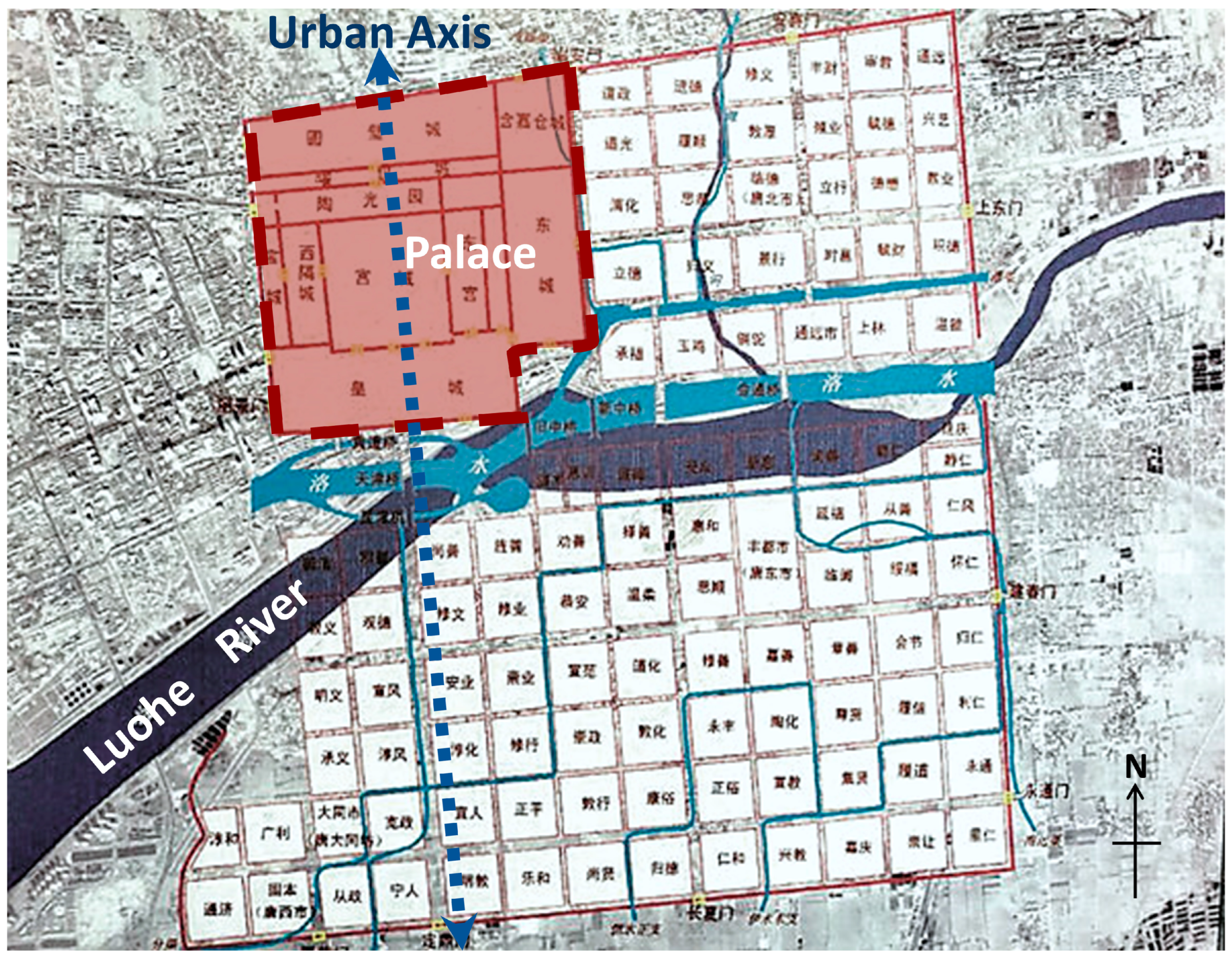
2.1.1. Pattern of the Urban Natural Landscape and Historical Spatial Structure

With Longmen Mountain to the south, Mang Mountain to the north, and Hangu Valley to the west, Luoyang is situated at the western end of the Yiluo Basin, forming an urban geographic space that is surrounded by mountains on three sides that is spacious in the east. The topography of Luoyang has not altered considerably since ancient times. The terrain is mountainous in the west and flat in the east, with mountains, hills, and plains interspersed, adding complexity to the landscape. There are six parallel rivers, and the two rivers of Yiluo are the two major ones in Luoyang. They are significant natural geographical features of the city. The city is a blend of landscape and natural endowment, and the ancient cities of Luoyang were distributed along the narrow east–west river valley plain, and the Luo River was the axis. The ancient city sites of Xia, Shang, Zhou, Han and Wei, Sui and Tang, and Jin and Yuan were preliminarily identified, and they were distributed in the strip area on both sides of the bank of the Luo River from the west to Jianhe, and from the east to the intersection of Yiluo. Only the Luo River can be the common coordinate to maintain their relationship (Figure 1).
The spatial structure of ancient Chinese cities is a figurative expression of traditional planning thought processes, as they contain the planners’ treatments of natural landscape patterns and the rulers’ will to power [33]. Although the ancient capital of Luoyang has been relocated several times over the ages, the emperor’s palace city and the city’s axis arising from it dominated the layout of the entire city, which highlighted the emperor’s authority and constituted the soul of the city, whether in the Han and Wei dynasties or the Sui and Tang dynasties. For instance, the restoration map of Luoyang City during the Sui and Tang dynasties revealed that the flowing Luo River split the city into two sections, the north, and south, with the palace city positioned in the north-west rather than in the city’s center (Figure 2). Since the city’s central axis is to the west, and it is not a centrally symmetrical city, Luoyang’s layout under the Sui and Tang dynasties differed from that of most ancient Chinese cities. According to the archives, a unique landscape city axis pattern was created when Yu Wen Kai settled the palace opposite Longmen Ique and extended it south to Shangqing Palace, on Mount Mang [34].

2.1.2. The Evolution of the Historical District in Luoyang

The capital of the state was established in Luoyang in 1046 BC, following the Western Zhou Dynasty’s overthrow of the Yin Dynasty. On the northern bank of the Luo River, the Duke of Zhou constructed King City and Cheng Zhou City. From then, Luoyang began its 1500-year history as a capital. After the Northern Song Dynasty, Luoyang gradually declined because of years of war, a shift in economic strength from the north to the south, and the degradation of the environment. The city’s status was downgraded to that of a general prefecture, and its size was drastically reduced. The ancient Jin Yuan City of Luoyang was only 1.96 square kilometers, only one-twenty-fourth the size of Luoyang City during the Sui and Tang dynasties. Furthermore, the building’s above-ground portion of the previously prosperous capital city has vanished. Prior to its liberation, the old city of Luoyang was the location of the ancient cities of the Jin, Yuan, Ming, and Qing dynasties. After four urban master plans based on the old town, Luoyang evolved into its current multi-axis, composite urban spatial pattern after the country was founded.
With the gradual excavation of ancient ruins—including those from the Eastern Zhou Dynasty’s royal city and Luoyang City during the Sui and Tang dynasties—Luoyang is gradually regaining its urban memory and enhancing the landscape features of its historical city, which are part of its magnificent, historical royal capital. The heritage venue, which serves as the historical landscape’s anchor point, generates material and immaterial radiation to the historical landscape’s layered space. It also influences the macroscopic urban spatial structure and the microscopic neighborhood style. This power is the primary force behind the historical urban landscape’s overall spatial formation [35]. It was posited that Luoyang’s urban space has undergone a unique process of historical landscape formation, which has included continuous reverse layering. In the paper, the historical landscape layering research should be separated into three periods, namely: the pre-modern period (1915–1950); the period of urban industrialization (1950–1985); and the period of rapid urbanization (1985–2020) (Figure 3).

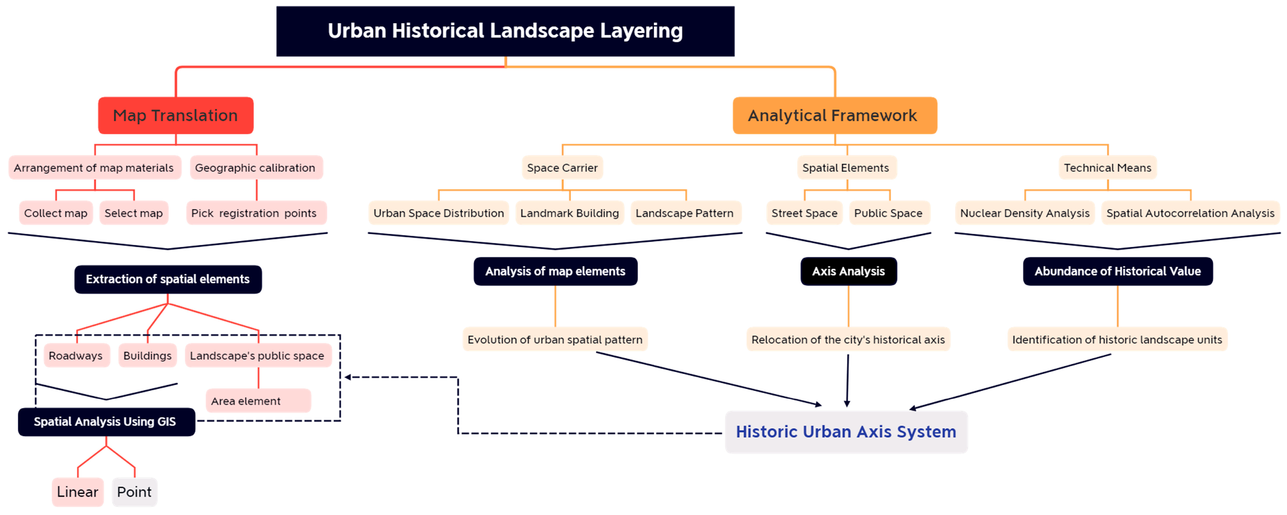
2.2. An Analytical Framework for Historical Urban Landscapes

Hierarchical historical landscape analysis is an ephemeral analysis of historical landscapes’ heritage elements, which describes an urban spatial transformation through the superposition of overall or local historical heritage elements in each period [36]. This paper extracted historical urban landscape spatial carriers, such as linear structural elements (roads and alleys), landmark buildings, and landscaped public spaces. The different historical landscape carriers were superimposed vertically, with time attributes as vertical clues. The translated historical landscapes of different periods were analyzed through superimposed maps, using ArcGIS software and its spatial analysis method. Additionally, we extracted the raster data to investigate the spatial agglomeration relationships (Figure 4).

2.2.1. Method for Hierarchical Study of Urban Spatial Structure

The extraction of spatial linear elements, particularly skeleton elements, is the key ingredient in a layered analysis of urban spatial structures. The city wall was an extraordinarily intuitive and prominent extraction feature from Luoyang’s pre-modern city. The city’s axis also has been determined based on the distribution of significant highways and landmark structures; however, in the modernization period only remnants of the Luoyang city walls remain, and their skeletal elements are no longer effective for control. The road patterns, architecture, and place elements all impact the functional structure of urban spaces [37]. The leading road network controls the linear spatial features, and the changing paths of urban roads over time serve as a key reference to mark the trajectory of a city’s historical spatial axis.

2.2.2. Method of Layered Analysis for Landscaped Public Areas (Landmark Building)

By investigating the spatial distribution of the research object and analyzing its spatial clustering relationship using the ArcGIS spatial autocorrelation analysis method, the landscape space and significant landmarks within it were utilized as micro-level layered carriers, to assist in analyzing the spatial value abundance of the historical landscape. The first procedure involved conducting a nuclear density analysis of frameworks from different eras. Nuclear density analysis is used to calculate the density of point elements in their immediate surroundings, and this index can clearly reflect the clustering and degree of dispersion among historical landscape elements [38]. In order to further identify the distribution trend of historical landscape elements in this study, the ArcGIS global autocorrelation analysis tool was used to analyze and judge their spatial clustering characteristics [39]. Moran’s I index is generally used to reflect results. If the index is positive, it indicates that the object has a significant spatial positive correlation in spatial distribution, which is reflected in the historical landscape object, and this indicates a high-value historical landscape clustering, or a low-value historical landscape clustering.

2.3. Historical Map Translations

Historical map translation is the identification and extraction of the historical landscape elements that are expressed in historical maps and of the spatial fall and correction in the historical town status map [40]. This is used to form a historical map of a city, according to modern cartographic standards. In order to visually portray the information about the current city on modern maps [41], it is important to utilize the historical map translation technique to convert the early historical maps into integrated history maps of the city, using modern maps as the map foundation. Using digital tools, digitally processed historical materials gradually started being introduced in large quantities into the study of urban historical morphology, with the help of ArcGIS [42]. Changes in the spatial extent of cities and the migration of urban centers can be more easily traced through ArcGIS [43]. Today, it is possible to digitally translate historical maps based on ArcGIS to achieve quantitative descriptions and spatiotemporal mathematical analyses of historical urban spaces with sufficient accuracy.

2.3.1. Selection and alignment of Historical Maps

Several historical maps and satellite images from various periods were collected for this study and used as reference materials for the translation of historical maps, in conjunction with the city’s master plan and the historical city preservation plan. Two mapping maps were chosen as the baseline materials for the historical map translation, based on the completeness, clarity, and richness of the information expressed in the maps. In contrast, one intention map and one satellite image of the city were referenced. The 2019 Luoyang City Map data were used as the basis for interpretation. In this study, historical map information from different periods was aligned to the WGS84 coordinate system, which was positioned in ArcGIS, and information from the historical maps of different periods was input into the map database separately (Table 1).
During the map alignment process, using the map from 1915 as an example, fixed elements were identified from a modern satellite map and used as control points. Existing city gates and landmarks were then used as precise reference coordinates. The current satellite image of Luoyang City from Google Earth and the 1915 Luoyang City Map were imported into ArcGIS. Using the geographic alignment toolbar and using the current satellite map as the base map, the six control points on the map from 1915 and the current satellite map were clicked one-by-one, until they were aligned (Table 2).

2.3.2. Extraction of Spatial Elements

The quality of the historical data is not always good enough to apply it uniformly to the historical and contemporary maps of all cities. Therefore, the method of translating urban environmental elements must be simple. In this study, it was necessary to vectorize the classified elements into point elements, line elements, and area elements, according to their characteristics, because ArcGIS would have been unable to identify the spatial elements in the historical map directly [44]. Historical maps are translated in the following two steps: First, the spatial elements are classified, reorganized, and associated. Second, the spatial elements are vectorized, and three types of spatial elements are obtained in different historical periods’ roadways, buildings, and sites. The categorized elements are vectorized and predicated on their properties, as follows:
(1)
Roadways are converted into line elements, and roads from various eras are superimposed and compared.
(2)
Buildings are converted into point elements in order to identify changes in the density distribution of historical building elements over time.
(3)
The landscape’s public space is translated into an area element, which serves as an essential anchor point in the layered space for analyzing the radiating influence on the surrounding environment.

3. Results

3.1. Luoyang Historical Map Translation from the Pre-Modern Period

The opening of the railroad and the push of military and political forces during these changing times were the two main driving forces behind the change in the urban spatial structure of Luoyang during the pre-modern period. Following the completion of the Bianluo Railway in 1910, several streets, including East Xin’an Street and South Xin’an Street, were planned and constructed to the south of Luoyang’s East Station Square. In addition, ancillary facilities, such as locomotive factories, repair shops, and water towers, were also planned and constructed in this area. Wu Pei-fu, the warlords of the Direct Line’s core of power, expanded the West Engineering Camp and built the Guanghan Palace, Jiguang Building, the airfield, and other architectural facilities in 1920. The Nanjing National Government relocated the capital to Luoyang in 1932. It adopted the “Plan for the Prosperity of the Capital after the Return of the Central Government to Nanjing”, which included plans to build the Luoyang power plant and to establish the Luoyang branch of the Central Military Academy, which have been partially implemented since then [45].

3.1.1. Extraction and Mapping of Spatial Features

City gates and walls: The walls of Luoyang were repaired seven times during the Qing Dynasty, until 1939, when the nationalist government ordered their demolition because they could facilitate a counter-attack. The city was roughly a square, with 1400 m sides, and the city walls had 4 gates, each with a moon city and a pavilion, and a total of 39 low platforms around the city.
Street and alley space: The city’s spaces within the city walls were divided into four large blocks, with the main roads of the east, west, north, and south streets. They were categorized into three neighborhoods in the southeast corner, two in the southwest corner, three in the northeast corner, three in the northwest corner, one at the west gate, and two at the south gate. Numerous streets and alleys further divided the city’s space and extended deeper into the neighborhoods, forming 9 streets, 18 lanes, and 72 hutongs.
Landmark buildings: The main public buildings inside the gates included official buildings, religious buildings, and cultural buildings. There were also important commercial buildings outside the gates (Table 3).

3.1.2. Reconstruction of the Urban Spatial Pattern

Luoyang followed the traditional pattern of local Chinese cities in the pre-modern era, with city walls separating the inner and outer parts of the city. Temples stood within the city walls, and government offices, commanders, prisons, and other authorities were scattered throughout the city. Important religious and cultural buildings, such as the drum tower and the City God Temple, were arranged along one side of East–West Street, and yet, spatially, East–West Street was not in a central and symmetrical position. Therefore, it was difficult to identify it as the city’s central axis, either spatially or functionally. The historical mapping maps showed a misalignment between the spatial center of power and the spatial center of the city. In reality, this was just a spatial misalignment, but not in terms of perception. Because the powerful institutions occupied the city center as a matter of course in the traditional public opinion maps of Luoyang, and the city, as a symbol of power, produced various exclusive spaces to delineate different social classes, it is believed that the central axis of Luoyang during this period was recognized as a conceptual axis rather than one that actually existed. Notably, Wenfeng Pagoda, Ancestor Temple, Four-eye Well, a lake, and a large green area, constituted the only landscape units within the city walls. These were located at the eastern end of Donghe Lane, which was in the southeast corner of the city.
Outside the city walls, Luoyang City developed a city gate annex area along the four city gates, the majority of which were streets with concentrated commercial operations or handicraft production, with the leading merchant houses concentrated in the area of Nanguan, from Yandiankou to Xiaoshichao. The small stone bridge led westward to the Luze Hall. Further south, at the end of Zhugan Lane, was the Shan-Shaan Hall, another Chamber of Commerce building. Parallel to the south side of the city wall, Ma Shi Street continued west to the Zhou Gong Temple, which was one mile outside of the city. The fur stores were located in Dongguan and Xinjie, and the Yingen Gate led 15 km east, to the Baima Temple, with other temples (the Wenmiao and Guandi temples) along this route. Dongguan was also a Muslim settlement, as the Muslim Hutong and Dongguan Mosques were located there.
The massive development of the city gates’ annex area was obviously not a spillover of functional urban land because there were still expansive fields in the northwest corner of Luoyang at this time. The land outside the city’s walls belonged to the marketplace, as it was less expensive to live in and better suited to commercial development. The larger salt houses were situated close to Beiguan and the railway station (i.e., today’s Luoyang East Station), which had grown in magnitude due to the introduction of the railway zone. Intriguingly, instead of choosing the city’s original power space as its base camp, the new warlord, Wu Pei Fu, who was the representative of the new power, built the West Engineering Camp on the west side, away from the old city. It was connected to the city via the road, west of the Zhou Gong Temple, and Ma Shi Street. Therefore, an east–west corridor along the Luo River formed the city’s axis of development during this period (Figure 5).

3.2. Historical Map Translations from the Period of Urban Industrialization

When the country was first founded, 7 of the 156 key construction projects were placed in Luoyang, and Luoyang was designated as one of the 8 key planning cities for new industries. Through this, the framework, scale, structure, and form of the modern city were formed. The first urban master plan avoided the three great sites of the Han and Wei capitals, the Eastern Zhou royal city, and the Sui and Tang capitals by situating industrial construction in an area west of the Jianhe River, far from the old town. This new model of building a new city far from the ancient city is known as the Luoyang model and it established a precedent for protecting cultural relics and large sites [46].

3.2.1. Extraction and Mapping of Spatial Features

Roads’ spatial patterns: The old city district built the ring road and the green belt around the city, opened Zhongzhou East Road as the east–west arterial road, and widened the former North–South Street as the principal north–south arterial road within the old city. Xigong District used the east–west direction of Zhongzhou Road as the horizontal axis and the north–south direction of Stadium Road and Golden Valley Park Road as the vertical axis. Circularly arranged, the roads in the Jianxi District intersected in both directions. The east–west arterial road traversed the entire industrial area and connected to the city center, whereas the north–south route was primarily used to link factories with residential areas and to communicate with the east–west arterial road.
Landmark buildings: A large number of residential buildings, office buildings, and commercial buildings were designed and built in the Soviet style, in Jianxi District and Xigong District, during this time. In addition, Xigong District planned Wangcheng Park on the historical site of Zhouwangcheng to protect it, and constructed the Luoyang City Museum (now the Palace of Mass Art) nearby (Table 4).

3.2.2. Alteration of Urban Spatial Configuration

During the period of urban industrialization, the city of Luoyang was arranged from west to east, with production areas, residential and storage areas, and cultural, educational, and scientific research areas forming a belt-like urban distribution. The old city and Chanshuihe district were primarily occupied by light industry, then residential and commercial areas, in an attempt to preserve the historical space’s original appearance. However, the city walls and gates have long since disappeared, and only the moat vaguely outlines the square form of the former city of Jin Yuan. Youth Palace Square was constructed on the site of the former Henan Provincial Government Office, which was surrounded by commercial and cultural buildings such as the Old City Mall, the People’s Cinema, and the Luoyang Theater. At the time, this comprised the commercial core of the historical city. The landscaped space, of which Wenfeng Pagoda was the visual center in the southeast corner of the city during the Republican period, was forgotten. This was apparent in satellite images from the time, in which buildings were seen to surround the surrounding area, the lake had disappeared, and the wasteland had become overgrown with weeds.
Spatially, Zhongzhou Road connected different areas of the city from west to east, and it was a crucial horizontal part of the city’s skeleton. The city’s vertical central axis started from Luoyang Station in the north, with Jinguyuan Road as the skeleton and Xigong Stadium as the southern terminal. The city center square was set at the intersection with the horizontal axis. Public facilities, including department stores, banks, hostels, post offices, and telecommunications, were arranged around the square, making it the administrative, commercial, and transportation center. Jianxi District was an industrial zone for the production of machinery. By the West Zhongzhou Road, it was split into two groups: the south side was the living area and the north side was the production area. The two areas had a parallel, corresponding arrangement and a green isolation zone was planned between them. At a particular time, the majority of workers from across the nation who supported their construction relocated to this area. The landmark buildings of Guangzhou Mall and Shanghai Mall constituted a unique cultural enclave, which created a distinct experience of life in the city’s local narrative (Figure 6).

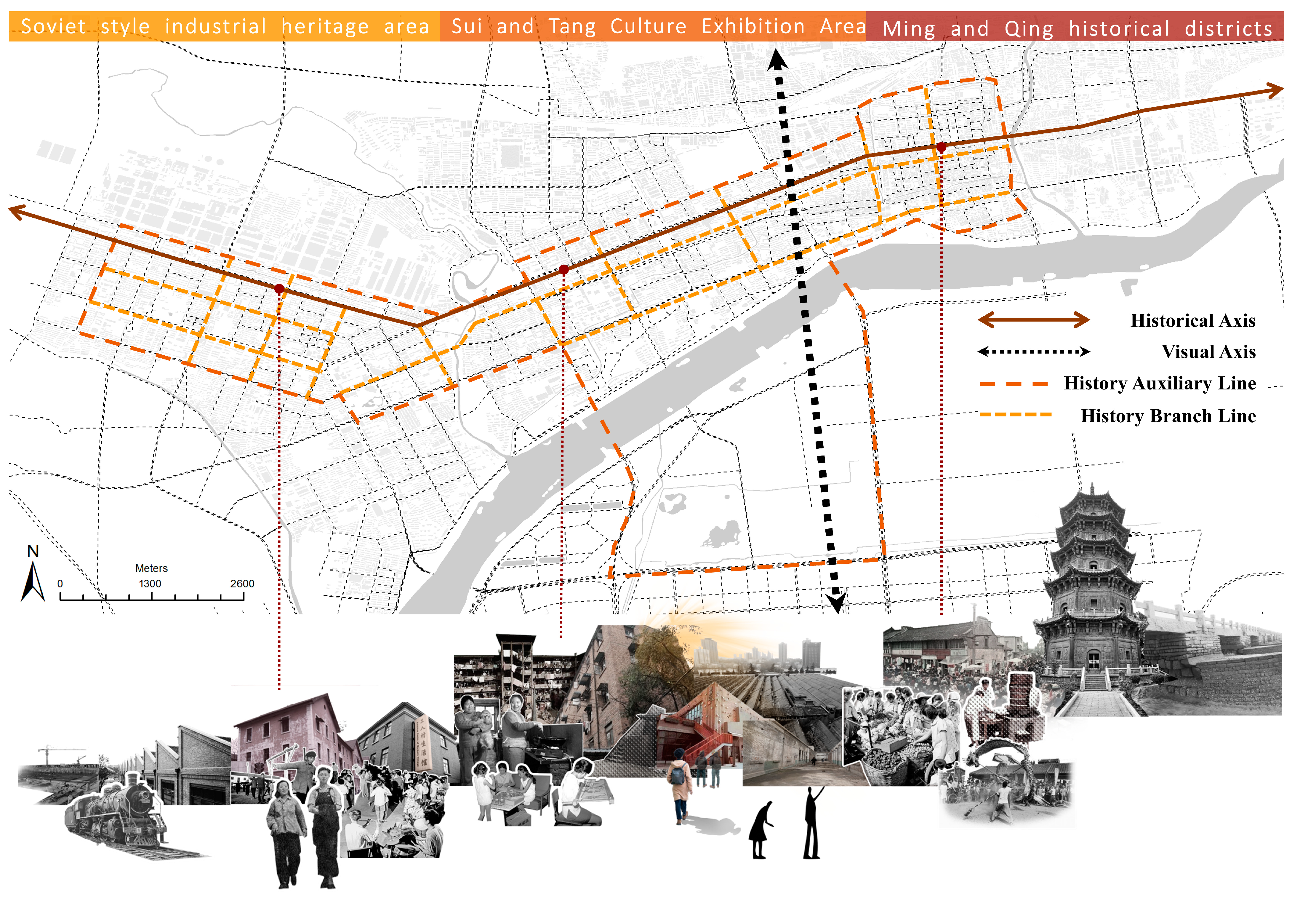
3.3. The Rapidly Urbanizing Period’s Historical Urban Landscape Layers

After 1993, Luoyang’s urban orientation shifted significantly, repositioning the city as a national historical and cultural city, a renowned ancient capital, and a tourist destination. The third urban master plan pushed the metropolitan area of Luoyang southward, across the Luo River. The city was developed south of the river with the intention of constructing the Luonan New District, which would transform it from a single ribbon city (as it was in the 1970s), into a modern, multi-group, circle-type urban structure and form. With the strengthening of the national drive to protect historical and cultural heritage in the new millennium, the protection of historical and cultural cities became a prerequisite for the fourth urban master plan. The protection and utilization of site space and the restoration of the city’s historical and cultural landscape became the primary impetus for urban renewal and construction during this period.

3.3.1. Anchoring of Historical Urban Landscape Spaces

Luoyang’s urban spatial pattern was a decentralized, polycentric structure during this period, with the Luo River as the axis; vertical and horizontal expressways, main city roads, and peripheral roads as the backbone; and green belts connecting the three ancient city sites. Ruins were used as permanent green areas, and the ruins of Zhoushan and Sui Tang City were used to form two natural green areas, which were embedded in the city of Jianxi and Luonan. Additionally, the new Luopu Park, Luoshen Park, and other scenic waterfront gardens were integrated into the ecological water greenway that was created by combining the Luo River, the Jian River, and the Stalking River. From a spatial perspective, Zhongzhou Road linked the central green squares of each city subdistrict, in turn, as follows: Youth Palace Square, Yingtianmen Square, Zhou Wangcheng Square, and Peony Square. It passed through Wangcheng Park, Peony Park, and other parks and green areas. This formed a horizontal, ecological, green corridor, which was intertwined and linked to the green belt that was formed by the natural water system. This embedded the historical urban landscape space naturally in the city and formed a good ecological landscape pattern.
The anchoring force of the historical urban landscape’s layered space was also represented in the landscape restoration of the site’s space. First, the construction of Sui Tang Luoyang City Ruins Park (including the scenic area of Kyushu Pond) in Luobei, which created an ecological green space with cultural, tourism, and leisure functions in the center of the city. Second, the site of Sui Tang Luoyang City (the Luonan part) was to be established as a permanent green space, the original road network pattern of the ancient city was to be gradually cleaned up and displayed, the ruins of the li-fang and city wall were to be displayed, and a new scenic area—a botanical garden —was to be constructed on the site of Sui Tang Luoyang City. Since it was situated on the site of Emperor Yang’s forbidden garden, the original Luoyang botanical garden was renamed Xiyuan Park. In addition, the 1970s expansion of the city center’s square in Xigong District was renamed Zhou Wangcheng Square, due to the discovery of carriage and horse pits dating back to the Eastern Zhou Dynasty. This, along with the Tianzi Driving Six Square and the historical districts in the east and southwest corners of the old city, formed the core historical and cultural exhibition area of Luoyang (Figure 7).

3.3.2. Reproduction of the Historical Urban and Cultural Landscape

In eastern culture, nature and culture are an inseparable, integral whole, and the cultural landscape is the link between nature and cultural heritage. This reveals the intimate nature of heritage, land, and landscape [47,48]. As a critical category of the traditional Chinese scenic concept, “eight scenes” refers to a cultural landscape formed from a combination of urban and natural features. The eight scenes of Luoyang, as recorded by the county government of Luoyang, depend on the elements of the city’s natural landscape, such as Mang Mountain, Luoshui, Yishui, and Longmen. The purpose is to provide people with places for daily leisure and recreation, which, thereby, become massive public cultural spaces in the city. Public urban spaces are realms that citizens use extensively. They can potentially take essential roles in enhancing the social qualities of human life by instilling a sense of place in the urban community.
Longmen Mountain and Mang Mountain are situated at opposite extremities of the Sui Tang Luoyang city axis. To protect the Sui Tang Luoyang site and to improve the landscape’s visual corridor, Luobei removed the structures in the palace area and the north central axis and reconstructed representative buildings on the Tang Dynasty palace axis, including Yingtianmen, Mingtang, and Paradise. Vertically, along the landscape pattern axis of Shangqing Palace Forest Park—from Yingtianmen Square to Dingdingmen Square—Longmen Yique was rebuilt, and new scenic spots were also constructed along this route: Jiuzhou Pond, the remains of Luoyang City from the Sui Tang Dynasty, a botanical garden, and Xingluo Lake Park. The botanical garden and Xingluo Lake Park have only recently been built along the route; therefore, the structural axis of urban space and the visual axis of landscape space now cross at the Yingtianmen–Mingtang line, making it the new gravitational center of the city.
In addition to restoring the landscape’s spatial axis, the cultural landscape of the Sui Tang Grand Canal in Luoyang has been reconstructed by tracing the historical landscape’s space. One example of this reconstruction is the restoration of the ancient city of Luoyi. “Luoyi” was the ancient name of Luoyang during the Cheng–Zhou period. The scenic spot contains protected buildings from many historical periods, such as Wenfeng Pagoda, the Henan Province Temple of Literature, Four-eye Well, and the ruins of Jin Yuan’s ancient city walls. This restored the spatial landscape pattern of the southeast corner of the ancient city of the late Qing Dynasty and the early Ming Dynasty. The moat water was also led to reproduce the site of Xintan, from the period of Wu Zetian, with the intention of restoring the old prosperous scene. Because of this, the scenery here is now a convergence of the ancient city’s thousand-year history. In addition, the Sui Tang Grand Canal Culture Museum has been designed and built at the confluence of the Luo River and the Chanshui River. Together with the precious heritage of the canal, such as the ruins of the Hanjia and Huiluo warehouses, this will represent a display space for the cultural heritage of the Grand Canal and reawaken the historical and cultural memory of the prosperity of Luoyang during the canal era, through the revitalization and translation of the historical and cultural landscape.

3.4. Value Analysis of Historical Urban Landscape Units

Conzen’s concept of morphological regions is generally used to analyze historical value abundance [49]. The overall spatial distribution density of historical landmark buildings can represent the distribution of historical value richness in a period. The higher the historical value abundance of a region, the greater the number of historical landmark buildings in that region [50]. Firstly, by analyzing the nuclear density of landmark buildings in different periods through the ArcGIS spatial analysis platform, we can obtain the density distribution map of historical building elements in each period. In the pre-modern era, the distribution of landmark buildings was concentrated in the southeast corner of the old city, particularly in the Nanguan district, which was strongly associated with the commercial prosperity of the area (Figure 8a). During the period of urban industrialization, the distribution of landmark buildings was concentrated in the Jianxi District, which was the focal point of urban construction at the time. This period left behind a significant number of industrial buildings, which were constructed in the Soviet-style (Figure 8b). During the period of fast urbanization, the high-density area of landmark structures migrated to the region of Yingtianmen Square—the Sui Tang Luoyang City Ruins Park—which is not unrelated to the restoration of the traditional landscape’s spatial pattern and the axis of the Sui Tang Palace City (Figure 8c).
Furthermore, in this study, the spatial overlay analysis tool in the ArcGIS platform was used to superimpose equal weights on the historical value richness distribution maps for each period, to obtain the total historical value richness layer accumulation map (Figure 8d). Through using the ArcGIS spatial correlation analysis tool, our correlation test was conducted on the general map of the landmark buildings from different periods of Luoyang’s historical urban area, based on the distribution of the value enrichment. The total density laminar map of the historical building elements was first converted to a raster image, and then the raster data were extracted to points, using the extraction tool. The global autocorrelation Moran I index value of 0.087, with a positive value, was calculated. This indicated that the value richness of the period had a high positive correlation with the spatial distribution. Further research using the high/low clustering analysis tool revealed that the Z score was 2.4, which indicated high aggregation (Figure 9). This indicated that the spatial clustering effect was more pronounced when the value richness of the area was greater. On this basis, combined with the regional distribution of the total laminar map of historical value richness in space, the historical urban area of Luoyang was divided into three distinct levels and types of historical landscape units: the Ming and Qing Dynasty historical protection district in the old city; the historical core display area for the palace ruins of Luoyang City, during the Sui and Tang Dynasties; and the Soviet-style industrial heritage area in Jianxi.

4. Discussion

How can a historical axis, which was once the capital of past dynasties, be recognized? Should we extract the core urban axis of the site of each royal city and perform an uncomplicated addition? Or should we select more to create a systematic historical axis? If so, what would the extraction standard be? The answer to these questions can be explored by going back to the spatial and temporal evolutionary track of the historical urban structure. Taking Luoyang as an example, its main urban area is dominated by the sites of the royal cities of the Eastern Zhou, Sui, and Tang dynasties, whereas the ancient capitals of the Han and Wei dynasties and the summer capital of the royal city were located on the city’s outskirts and in the surrounding districts and counties. The urban axis of each royal city should be identified in conjunction with historical maps and recent archaeological findings. Among them, the central axis of Luoyang City in the Sui and Tang Dynasties, and of Luoyang City in the Han and Wei Dynasties connected Mang Mountain, Palace City, and Longmen Yi Que (Wan’an Mountain Double Que). This better reflected the Chinese people’s understanding of space and social order, as well as the urban space’s response to the landscape’s culture. Archaeological findings at the location of the Eastern Zhou King City are still distant from the ideal city plan of Chinese medial symmetry, making it difficult to determine its spatial axis with conviction. The discrepancies between the spatial, physical, and conceptual axes of the walled cities of the Jin, Yuan, Ming, and Qing dynasties have already been discussed. Thus, the identification of the city’s core axis remains a challenging topic.
In contemporary times, the urban expansion of Luoyang has been intimately tied to the Luo River. Although its spatial vertical central axis has been continuously relocated, its horizontal skeleton element (Zhongzhou Road) has been organically linked to the spatial subdivision of the city along the Luo River and can be constantly extended eastward, to the Han and Wei sites, and to the Yanshui site in Shangdu. As a result, the Luoyang Historical and Cultural Protection City Plan adopted the Luo River as the natural axis to connect the series of sites in Luoyang with the Zhongzhou Road–301 National Road as the city’s historical axis in the 1980s [51]. Regrettably, the most recent historical preservation plan has ignored this significant historical axis and has blended the Zhouwangcheng Square axis with the Luonan Sui Tang site’s axis to form that era’s axis [52]. Thus the actual spatial axes and visual axes should be integrated into the building of historical axes and their systems in Luoyang’s historical city. Zhongzhou Road, as the east–west axis in the development of Luoyang City, can link the significant historical landscape spaces from different historical periods and the visual axis of the landscape spaces—as marked by the physical historical landscape elements, such as Mang Mountain, Mingtang, Longmen, and Ique—can echo the historical and cultural landscape of Luoyang. This forms the cross-shaped structural skeleton of the historical landscape axis system of Luoyang City.
Thanks to the concept of site protection in the city’s initial master plan, East–West Street and North–South Street still form a cross-shaped skeleton in the old city of Luoyang, which has preserved the historical aspect of the square grid. The primary alteration is located in the city’s northern region. Zhongzhou East Road was the east–west corridor of the old city area, based on Flag Temple Street, in front of the ancient city’s Henan Provincial Office, which runs parallel to East–West Street and shares the traffic pressure of its urban artery. In this study, the historical neighborhoods of the ancient city, which remain to this day, were extracted by using the intersection tool of the ArcGIS platform to correlate and overlay the road shapefile files of the pre-modernization period, the urban industrialization period, and the rapid urbanization period. Through the screening and evaluation of these historical streets, the system was used to build a longitudinal and horizontal urban historical axis system, which took the historical era axis and the visual axis of the landscape as the cross framework, with Ding Ding Road, Longmen Avenue, Gu Cheng Road, Wang Cheng Road, Xiuan Road, and Qingdao Road forming a road loop system. For the historical auxiliary routes, it extracted Paste Guo Xiang, Ma Shi Street, Kaixuan Road, and Jinghua Road in the horizontal direction, and Xin Street, North and South Street, Jingu Yuan Road, and Tianjin Road in the vertical direction, to improve the spatial accessibility of the road system in the historical landscape area (Figure 10).
As a result of the layered interactions between the natural and constructed environments during the city’s dynamic evolution, and since, it has served as a key development engine for the historical city, and the historical landscape is highly valued in local urban strategies. Contemporary urban renewal places more emphasis on “walkable cities and perceivable patterns” [53]. The latter especially reflects the echoing relationship between the city and its dependent regional environment and is closer to the living foundation of the urban organism. The urban pattern is perceived through physical roads, rivers, nodes, and landmarks, but the echoes on a larger scale also need to be made through non-physical landscape corridors and cultural routes. This system of urban historical axes will strengthen the social perception, cultural memory, and identity of historic urban landscapes and will contribute to the integration of historical and cultural landscapes [54,55].

5. Conclusions

The historical urban landscape has been essential in Luoyang’s socio-cultural identity and economic development. A considerable number of historical areas in Luoyang have been and are being redeveloped. Similar to many other historical cities in China and more widely, these historical areas should not be treated as isolated “islands” in the master and conservation plans. Instead, they should be intertwined with other urban features and recognition should be given to their ability to play a structural role in reconnecting historical and modern cities and in further guiding and improving urban development. The example of the historical–religious city of Ray has demonstrated that, although the landscape is fragmented in physical space, the residents do not perceive the landscape structure as fragmented. This indicates that the continuity of spatial structure can reverse the fragmentation of the physical space of the historical urban landscape at the level of social perception, but only if attention is paid to the spatial structure of the city and the integration of the landscape’s function [56].
This study has used the method of historical map translation to examine the construction and evolutionary process of Luoyang’s historical urban landscapes and its internal urban structure. The dynamic identity and changing character of cities can be represented through the identification of the structures, places, and other traditional cultural elements of historic urban landscapes and through the analysis of their historical contexts and evolution. This allows us to identify a city’s historical axis based on the spatial structure’s evolution over time. This can be one of the reference frames that guide today’s urban renewal. The future is a continuum of the past and present, and urban renewal is a technical method of the material form and a means of preserving the continuity and integrity of a city’s historical landscape [57]. The construction of an urban historical axis system can efficiently integrate all components of the urban spatial system, establish urban historical resource lines, and create a distinctive urban cultural belt.
A cultural landscape approach enables diverse communities to be seen as part of that landscape. That is cultural, historical, and political conditions that affect contemporary communities are part of human engagement with the place [58]. The cultural landscape approach can be a means of reuniting fragmented approaches to valuing and constructing the environments we inhabit, a means of overcoming the distinctions between the historical environment and new developments, and a means of uniting nature and culture and built heritage and context [59]. Treating the historical urban landscape as the infrastructure for livable cities is essential to ensuring the continuity of local culture and reconnecting the people and the places that together comprise cultural tourism sites [60]. In this sense, it is beneficial for achieving the balance between, and the fusion of, modern construction and historical inheritance in the process of urban renewal. The core of the multi-dimensional utilization of historical landscape resources in contemporary urban construction is to perpetuate the structure of linear features as far as possible. On this basis, the relationship between man and nature can be further developed in the continuous evolution of urban spaces. This paper can provide a reference for the inheritance and renewal of historical environmental protection in other cities with similar conditions.

Author Contributions

Conceptualization, S.D. and D.S.; methodology, S.D.; software, S.D.; validation, S.D. and D.S.; formal analysis, S.D.; investigation, S.D.; resources, S.D.; data curation, S.D.; writing—original draft preparation, S.D.; writing—review and editing, S.D.; visualization, S.D.; supervision, D.S.; project administration, S.D.; funding acquisition, S.D. All authors have read and agreed to the published version of the manuscript.

Funding

This research received no external funding.

Institutional Review Board Statement

Not applicable.

Informed Consent Statement

Not applicable.

Data Availability Statement

All the data used are reflected in the article. If you need other relevant data, please contact the author.

Conflicts of Interest

The authors declare no conflict of interest.

References

  1. UNESCO. World Heritage and Contemporary Architecture—Managing the Historic Urban Landscape; UNESCO: Paris, France, 2005. [Google Scholar]
  2. UNESCO. Declaration on the Conservation of Historic Urban Landscapes (WHC-05/15,GA/7); UNESCO: Paris, France, 2005. [Google Scholar]
  3. Rey-Perez, J.; Siguencia Ávila, M.E. Historic urban landscape: An approach for sustainable management in Cuenca (Ecuador). J. Cult. Herit. Manag. Sustain. Dev. 2017, 7, 308–327. [Google Scholar] [CrossRef] [Green Version]
  4. UNESCO. Recommendation on the Historic Urban Landscape; UNESCO: Paris, France, 2011. [Google Scholar]
  5. Briceno, M.; Sanchez, A.; Tamayo, J.; Izquierdo, H.; Ponsot, E.; Ulloa, R.; Camacho, L. Historical layers of the urban landscape of Ibarra, Ecuador. Rev. Geogr. Venez. 2021, 62, 256–271. [Google Scholar]
  6. Li, X.; Hou, W.; Liu, M.; Yu, Z. Traditional Thoughts and Modern Development of the Historical Urban Landscape in China: Lessons Learned from the Example of Pingyao Historical City. Land 2022, 11, 247. [Google Scholar] [CrossRef]
  7. Conzen, M.R.G. Alnwick, Northumbenrland: A Study in Town—Plan Analysis; George Philip SAGE Publications: London, UK, 1960. [Google Scholar]
  8. McHarg, I.L. Design with Nature; Wiley: New York, NY, USA, 1995. [Google Scholar]
  9. Rowe, C. Collage City; The MIT Press: Boston, MA, USA, 1984. [Google Scholar]
  10. OM, U. The Diatectic City; Skiraeditore: Milan, Italy, 1997. [Google Scholar]
  11. Cervelli, E.; Pindozzi, S. The Historical Transformation of Peri-Urban Land Use Patterns, via Landscape GIS-Based Analysis and Landscape Metrics, in the Vesuvius Area. Appl. Sci. 2022, 12, 2442. [Google Scholar] [CrossRef]
  12. Chen, J.; Park, H.; Fan, P.; Tian, L.; Ouyang, Z.; Lafortezza, R. Cultural Landmarks and Urban Landscapes in Three Contrasting Societies. Sustainability 2021, 13, 4295. [Google Scholar] [CrossRef]
  13. Taylor, K. The Historic Urban Landscape paradigm and cities as cultural landscapes. Challenging orthodoxy in urban conservation. Landsc. Res. 2016, 41, 471–480. [Google Scholar] [CrossRef]
  14. Oers, R.v.; Han, F.; Wang, X. The concept of urban historic landscape and its connection with cultural landscape. Chin. Landsc. Archit. 2012, 28, 16–18. [Google Scholar]
  15. Lin, Y.; Luo, P. A Study on the Implicit Structure of Historical Environment in Urban Space of Xuzhou. Sustainability 2022, 14, 6837. [Google Scholar] [CrossRef]
  16. Monavari, S.M.; Fard, S.M.B. A GIS Based Assessment Tool for Biodiversity Conservation. Int. J. Environ. Res. 2010, 4, 701–712. [Google Scholar]
  17. Dong, C. Urban historical landscape construction methods and designs: The case of the old town of Jingdezhen. Open House Int. 2019, 44, 13–16. [Google Scholar] [CrossRef]
  18. Tang, M.D.; Chen, T.C. Cultural Landscape Evolution Under Rapid Urban Development: A Case Study of Shichahai Historical Area in Beijing, China. In Proceedings of the 2nd International Conference on Logistics, Informatics and Service Science (LISS), Beijing, China, 12–15 July 2012. [Google Scholar]
  19. Leila Mahmoudi, F.; Marzieh, S.; Leila, S. Contextualizing Palimpsest of Collective Memory in an Urban Heritage Site: Case Study of Chahar Bagh, Shiraz-Iran. ArchNet-IJAR Int. J. Archit. Res. 2015, 9, 218–231. [Google Scholar] [CrossRef]
  20. Angel, S.; Parent, J.; Civco, D.L. The fragmentation of urban landscapes: Global evidence of a key attribute of the spatial structure of cities, 1990–2000. Environ. Urban. 2012, 24, 249–283. [Google Scholar] [CrossRef] [Green Version]
  21. Lu, X. The Spatial Structure of Chinese History; Guangxi Normal University Press: Guilin, China, 2014. [Google Scholar]
  22. Kainan, C. Study on the Explicit Characteristics and Value Features of Urban Physical Axes. Master’s Thesis, South China University of Technology, Guangzhou, China, 2016. [Google Scholar]
  23. Song, Y. Exploring the impact of urban axis structure on cities. In Proceedings of the 2019 14th Urban Development and Planning Conference, Zhengzhou, China, 27–28 August 2019; p. 4. [Google Scholar]
  24. Alvarez, J.J.G. Fragmentary industrial areas and urban renewal: The case of an industrial axis in Guadalajara, Mexico. Urban Des. Int. 2009, 14, 172–187. [Google Scholar] [CrossRef]
  25. Wang, J. Study of Traditional Urban Spatial Axes. J. Archit. 2003, 4, 24–27. [Google Scholar]
  26. Huang, X.S. Space, State, and Crowds: Urban Squares on Beijing’s Central Axis in the 1910s. Archit. Theory Rev. 2019, 23, 214–232. [Google Scholar] [CrossRef]
  27. Lv, Z. Identification and Conservation of Beijing’s Central Axis Based on the Historic Urban Landscape. Landsc. Archit. 2022, 29, 20–25. [Google Scholar] [CrossRef]
  28. Wang, Y. Nanjing Urban Space Creation Study. Ph.D. Thesis, Wuhan University, Wuhan, China, 2010. [Google Scholar]
  29. Su, X.; Sigley, G.G.; Song, C. Relational Authenticity and Reconstructed Heritage Space: A Balance of Heritage Preservation, Tourism, and Urban Renewal in Luoyang Silk Road Dingding Gate. Sustainability 2020, 12, 5830. [Google Scholar] [CrossRef]
  30. Liao, Q.P.; Yang, S.L. Exploration on the impact of traditional Chinese philosophy on urban planning in ancient China. In Proceedings of the 2nd International Conference on Civil Engineering and Transportation (ICCET 2012), Guilin, China, 27–28 October 2012; p. 143. [Google Scholar]
  31. Antrop, M. Landscape change and the urbanization process in Europe. Landsc. Urban Plan. 2004, 67, 9–26. [Google Scholar] [CrossRef]
  32. San-Antonio-Gomez, C.; Velilla, C.; Manzano-Agugliaro, F. Urban and landscape changes through historical maps: The Real Sitio of Aranjuez (1775-2005), a case study. Comput. Environ. Urban Syst. 2014, 44, 47–58. [Google Scholar] [CrossRef]
  33. Cai, F. The City Inside and Outside the Map—A Comparison of City Maps on the Intangible Understanding of Chinese Cities. Architects 2011, 151, 95–98. [Google Scholar]
  34. Committee, L.L.H.C. Luoyang City Chronicle; Zhongzhou Ancient Books Publishing House: Zhengzhou, China, 2006; Volume 1. [Google Scholar]
  35. Liu, Y. A Preliminary Study on “Anchoring-Layering” Theory for Cognition and Conservation of Historic Urban Landscape. Ph.D. Thesis, Tsinghua University, Beijing, China, 2014. [Google Scholar]
  36. Zhang, X. A Study of Chongqing’s Historic Urban Landscape Layers Based on Historical Map Translation. Master’s Thesis, Chongqing University, Chongqing, China, 2019. [Google Scholar]
  37. Shen, D.; Dong, S. Transition of Urban Morphology in the Mountainous Areas Since Early-Modern Times from the Perspective of Urban Historic Landscape—A GIS Tools and Historical Map Translation Approach. Sustainability 2022, 14, 2896. [Google Scholar] [CrossRef]
  38. Wang, Q.; Bing, H.; Wang, S.Q.; Xu, Q. Study on the Spatial Distribution Characteristics and Influencing Factors of Famous Historical and Cultural Towns or Villages in Hubei Province, China. Sustainability 2022, 14, 3735. [Google Scholar] [CrossRef]
  39. Wu, H.; Xu, H.; Tian, X.; Zhang, W.; Lu, C. Multistage Sampling and Optimization for Forest Volume Inventory Based on Spatial Autocorrelation Analysis. Forests 2023, 14, 250. [Google Scholar] [CrossRef]
  40. Lv, Q. A Preliminary Study on the Spatial Form Evolution of Jiangbei City in Chongqing in Modern Times Based on Map Analysis. Master’s Thesis, Chongqing University, Chongqing, China, 2021. [Google Scholar]
  41. Li, J.; Dong, W. An integrated research approach on city map decoding based on reshaping decoding of ancient map of Hangzhou city. City Plan. Rev. 2008, 2, 93–98. [Google Scholar]
  42. Berila, A.; Isufi, F. Two Decades (2000-2020) Measuring Urban Sprawl Using GIS, RS and Landscape Metrics: A Case Study of Municipality of Prishtina (Kosovo). J. Ecol. Eng. 2021, 22, 114–125. [Google Scholar] [CrossRef]
  43. Alvares-Sanches, T.; Osborne, P.E.; James, P.A.B.; Bahaj, A.S. Tracking a city’s center of gravity over 500 years of growth from a time series of georectified historical maps. Cartogr. Geogr. Inf. Sci. 2020, 47, 524–536. [Google Scholar] [CrossRef]
  44. Zhang, N.; Liu, F.; Zhao, P.; Sun, S.; Tan, L.; Zeng, Y.; Duan, S.; Fang, X.; Kim, H.-j. Extraction and Digital Translation of Urban Spatial Elements Based on a Series of Historical Maps. Mob. Inf. Syst. 2022, 2022, 1–12. [Google Scholar] [CrossRef]
  45. Li, Z.; Zheng, Z. General History of Luoyang; Zhongzhou Ancient Books Publishing House: Zhengzhou, China, 2001. [Google Scholar]
  46. Li, H. Luoyang Model: The First Five-Year Plan to Avoid the Old City and Build a New District. City Plan. Rev. 2017, 41, 114–116. [Google Scholar]
  47. Hussein, F.; Stephens, J.; Tiwari, R. Cultural Memories and Sense of Place in Historic Urban Landscapes: The Case of Masrah Al Salam, the Demolished Theatre Context in Alexandria, Egypt. Land 2020, 9, 264. [Google Scholar] [CrossRef]
  48. Taylor, K. From Physical Determinant to Cultural Construct: Shifting discourses in reading landscape as history and ideology. In Proceedings of the Fifteenth Annual Conference of the Society of Architectural Historians Australia and New Zealand, Melbourne, VIC, Australia, 28 September–1 October 1998; pp. 371–378. [Google Scholar]
  49. Whitehand, J.W.R. British urban morphology: The Conzenian tradition. Urban Morphol. 2001, 5, 103–109. [Google Scholar] [CrossRef]
  50. Cen, B. A Study on the Stratification of Dalian Urban Historical Landscape (1898–1945). Master’s Thesis, Liaoning Normal University, Dalian, China, 2021. [Google Scholar]
  51. Li, G. The capital of Luo in the sky is finely sculpted—Luoyang Historical and Cultural City Protection Plan. City Plan. Rev. 1989, 2, 50–53. [Google Scholar]
  52. Yang, L.; Xu, M.; Zhao, X.; Such, Y.; Feng, X. Exploring the Protection Planning of Historical and Cultural Cities in the New Era—Luoyang as an Example. City Plan. Rev. 2022, 46, 46–58+81. [Google Scholar]
  53. Zhang, K. Promoting the Optimization of the Spatial Structure of the National Land of Famous Cities with the Clues of Human-Land Relationship: The Case of Kunming, a Famous City of Highland Lakes. Herit. Archit. 2022, 27, 12–20. [Google Scholar] [CrossRef]
  54. Garau, C.; Annunziata, A.; Yamu, C. The Multi-Method Tool ‘PAST’ for Evaluating Cultural Routes in Historical Cities: Evidence from Cagliari, Italy. Sustainability 2020, 12, 5513. [Google Scholar] [CrossRef]
  55. Ziyaee, M. Assessment of urban identity through a matrix of cultural landscapes. Cities 2018, 74, 21–31. [Google Scholar] [CrossRef]
  56. Khaniki, Z.A.; Darabi, H.; Irani-Behbahani, H. Integrated Analysis of Urban Landscape Fragmentation (Case Study: Historical-Religious City of Ray). Int. J. Environ. Res. 2015, 9, 511–522. [Google Scholar]
  57. Zhao, Y.; Liu, J.; Zheng, Y. Preservation and Renewal: A Study on Visual Evaluation of Urban Historical and Cultural Street Landscape in Quanzhou. Sustainability 2022, 14, 8775. [Google Scholar] [CrossRef]
  58. Wang, S.; Gu, K. Pingyao: The historic urban landscape and planning for heritage-led urban changes. Cities 2020, 97, 102489. [Google Scholar] [CrossRef]
  59. Punekar, A. Value-led heritage and sustainable development: The case of Bijapur, India. In Designing Sustainable Cities in the Developing World; Watson, G.B., Zetter, R., Eds.; Ashgate: Aldershot, UK, 2006; pp. 103–120. [Google Scholar]
  60. Siguencia Avila, M.E.; Rey Pérez, J. Heritage values protection, from the monument to the urban dimension. Case study: The historic centre of Santa Ana de los Ríos de Cuenca, Ecuador. Hist. Environ. Policy Pract. 2016, 7, 164–176. [Google Scholar] [CrossRef] [Green Version]
Figure 1. Luoyang capital city site map of the past generations. (Map retrieved from the Luoyang Urban Planning Exhibition Hall.)
Land 12 00663 g001
Figure 2. Restoration of the capital city of Luoyang in the Sui Dynasty. (Map retrieved from the book The History of Chinese Architecture.).
Land 12 00663 g002
Figure 3. Luoyang City development history.
Land 12 00663 g003
Figure 4. An analytical framework for historical urban landscapes.
Land 12 00663 g004
Figure 5. Historical translation map of Luoyang in the pre-modern period. (Adapted according to historical maps of Luoyang from 1915 to 1932.).
Land 12 00663 g005
Figure 6. Historical translation map of the urban industrialization period. (Adapted according to historical maps of Luoyang and satellite pictures between 1969 and 1978.).
Land 12 00663 g006
Figure 7. Historical landscape layers of Luoyang in the period of rapid urbanization. (Adapted according to an urban map of Luoyang from 2019).
Land 12 00663 g007
Figure 8. Historical value richness chart: (a) in 1915; (b) in 1970; (c) in the current time; (d) stacked graphs (Chart provided by ArcGIS Screenshot).
Land 12 00663 g008
Figure 9. (a) Space autocorrelation statement; (b) High/low clustering analysis (images provided by ArcGIS Screenshot).
Land 12 00663 g009
Figure 10. Luoyang urban historic axis system.
Land 12 00663 g010
Table 1. Historical maps and satellite image of Luoyang.
PeriodsThe Pre-Modern TimesUrban Industrialization
NameLuoyang City and the Four Customs in 1915Situations around Luoyang in 1932Travel map of Luoyang in 1969Satellite pictures of Luoyang in 1978
SourceBeijing Army Survey BureauGeneral Bureau of Land Survey, Headquarters of the StaffChaohua Publishing Presshttps://earthexplorer.usgs.gov/ UGL (accessed date 4 September 2022)
PreviewLand 12 00663 i001Land 12 00663 i002Land 12 00663 i003Land 12 00663 i004
Table 2. Six precise reference coordinates.
No.Reference CoordinateLongitudeLatitude
1Shrine Temple112.4624734.67612Land 12 00663 i005
2Lijing Gate112.4714834.68124
3Town God’s Temple of Henan112.4724134.68302
4Luze Guild Hall112.4891434.6793
5Drum tower112.4831134.68294
6Shanshan Guild Hall112.4820434.67624
Table 3. Extraction of urban spatial elements in pre-modern Luoyang.
Element TypeFeature Extraction
City gateLijing Gate
StreetsNorth and South Street, East and West Street, Mashi Street, New Street, Donghe Lane, Tieguo Lane, etc.
Government buildingsHenan Provincial Government Office, the former site of the office of the Eighth Route Army in Luoyang, Luoyang Western Industrial Barracks
Cultural architectureConfucius temple of Henan
Religious architectureTaoist temple, Shrine Temple, Anguo Temple, Town God’s Temple of Henan, Dongguan Mosque
Chamber of Commerce
Building
Luze Guild Hall, Shanshan Guild Hall
Landscape architectureDrum tower, Wenfeng tower in Luoyang, Small stone bridge
Residential buildingVilla Yard
Table 4. Extraction of urban spatial elements in the urban industrialization period.
Element TypeFeature Extraction
City gateJian’an Gate
StreetsZhongzhou Road, Jinguyuan Road, Dingding Road, Jiudu Road, Wangcheng Road, Xiyuan Road
Historical sitesHanjia Granary Site
Cultural architectureMain Exhibition Building of Luoyang Museum
Landscape architectureSite of Eastern Zhou Capital
Commercial buildingsShanghai Market, Guangzhou Market
Residential buildingLuoyang Jianxi Soviet-style architectural complex
Disclaimer/Publisher’s Note: The statements, opinions and data contained in all publications are solely those of the individual author(s) and contributor(s) and not of MDPI and/or the editor(s). MDPI and/or the editor(s) disclaim responsibility for any injury to people or property resulting from any ideas, methods, instructions or products referred to in the content.

