1. Introduction
Rural settlement refers to population settlements at a certain scale and is closely related to agricultural production, also known as rural residential areas or rural settlements. Rural settlement is a special artificial and semi-artificial landscape on the Earth’s surface and a spatial phenomenon with regional characteristics [
1]. The spatial characteristics and evolution process of rural settlement are the concentrated embodiment of the human–land relationship in vast rural areas [
2]. With the rapid progress of urbanization, rural society has undergone dramatic changes. As the spatial carrier of rural social and economic development, the spatial layout, form, scale, and structure level of rural settlements are also undergoing significant transformation [
3,
4]. The impact of urbanization on rural settlement space is manifested in two aspects: first, expansion of rural settlement space. Urbanization has brought development opportunities to some villages, causing them to develop by virtue of their own resource advantages and realizing the scale expansion of settlement space. The second aspect is the gradual decline and disappearance of the settlement. Affected by the expansion and development of cities and towns, rural settlement space in the suburbs of cities and towns is gradually being swallowed up by towns, and the nature of the settlement space has fundamentally changed [
5,
6]. Therefore, it is of practical significance to explore the evolution and driving mechanism of rural settlements for solving rural diseases caused by excessive urbanization speed.
Rural settlement is the spatial carrier of rural social economy, farmers’ production and life, cultural traditions and customs, etc. The study of the evolution process, pattern, effect, and mechanism of rural settlement is the core content of modern rural geography research [
7,
8]. Kohl [
9] systematically expounded the formation of rural settlements for the first time, and analyzed the relationship between the distribution and geographical environment. Demandeon [
10], Brunhes [
11], and Hoffman [
12] provided empirical discussions on the rural settlement spatial evolution characteristics in France, Germany, and Bulgaria. After the 1960s, the study of rural settlements entered the quantitative stage, paying more attention to the impact of human decision-making behavior on formation and development, and emphasizing a combination of qualitative and quantitative research. For example, Cater [
13], Palmer [
14], and John [
15] studied the spatial distribution characteristics from a sociological perspective. In the 1990s, the rural settlement research paradigm began to transform into the socio-humanistic. It has gradually become a trend to explore rural settlements from the perspectives of sociology, ecology, economics, etc. Rural communities, urban–rural relations, rural policies, population and settlements, and rural settlement models have gradually become the main research contents [
16,
17,
18,
19,
20]. Since the beginning of the 21st century, with the rapid development of urbanization, the settlement spatial structure has undergone significant changes, and study of the evolution has gradually become a hot topic. For example, Ruda [
21] explored the morphological structure and scale change characteristics based on the industrialization influence. Matteucci [
22] studied the settlement expansion into the outer suburbs of Buenos Aires Province, Argentina, and found the settlement spatial expansion mainly occurred in the high-altitude areas. Njoh [
23] analyzed the evolution process of settlements by using the land price fluctuation. Different methods such as Voronoi diagram, CA model, and landscape pattern index were used to quantitatively analyze the evolution of settlements [
24,
25,
26,
27]. In the early research stage of the influencing mechanism, it was generally believed that the physical geographical environment was the primary one, and the influence of geographical environmental factors on settlement morphology was discussed [
28,
29,
30]. With the development of productivity, the influence of human factors on settlement layout and form gradually increases, and the influencing factors of the settlements pattern gradually extend to the humanities and social field, involving government policies, land system, population migration, human decision-making behavior, urban–rural interaction, population density, social culture and other aspects [
31,
32,
33]. On the whole, the research in western countries has gradually diversified, and in-depth study of rural settlements combined with multidisciplinary research has become the main direction.
The research on rural settlements in China was relatively late and mainly focused on rural settlements, agricultural regionalization, and agricultural land use in the initial stage [
34,
35,
36,
37]. Especially since the 1990s, with the influence of the development of new countryside, domestic scholars have been attracted to the topic, providing different perspectives such as settlement scale [
38], settlement system [
39], evolution mechanism [
40,
41], spatial form [
42,
43], and spatial reconstruction [
44,
45], and different scales such as province [
46,
47], city [
48,
49], county [
50,
51], and village [
52,
53]. A systematic and comprehensive study of rural settlements was conducted by using different methods such as “3S” technology [
54,
55,
56], CA model [
57], CLUE-S model [
58], and landscape pattern index [
59,
60,
61]. By reviewing the existing research results, it can be found that: (1) the current research has gradually deepened from the macro scale to the county and village scale; the research scale has been increasingly refined. (2) The research content showed a trend of diversification and integration, among which the evolution mechanism and spatial reconstruction of settlements were the focus of attention, especially in exploring the influencing factors of settlement evolution, in addition to paying attention to the constraints of geographical factors [
62], economic factors [
63], institutional policies [
64], and other factors that have become important analysis content. (3) The research method showed a shift from single statistical analysis to integrated analysis of multiple methods. In particular, the application of new technologies and methods made the research process of rural settlements more scientific, which provided support for further revealing the mechanism of settlement evolution. However, most studies have analyzed the spatial distribution of settlements and influencing factors in different periods, and few studies have explored the scale and influencing factors of the overall rural settlements. There was a lack of summary of the rural settlements’ evolution rules in typical regions, and the research on the evolution mechanism of rural settlements was insufficient.
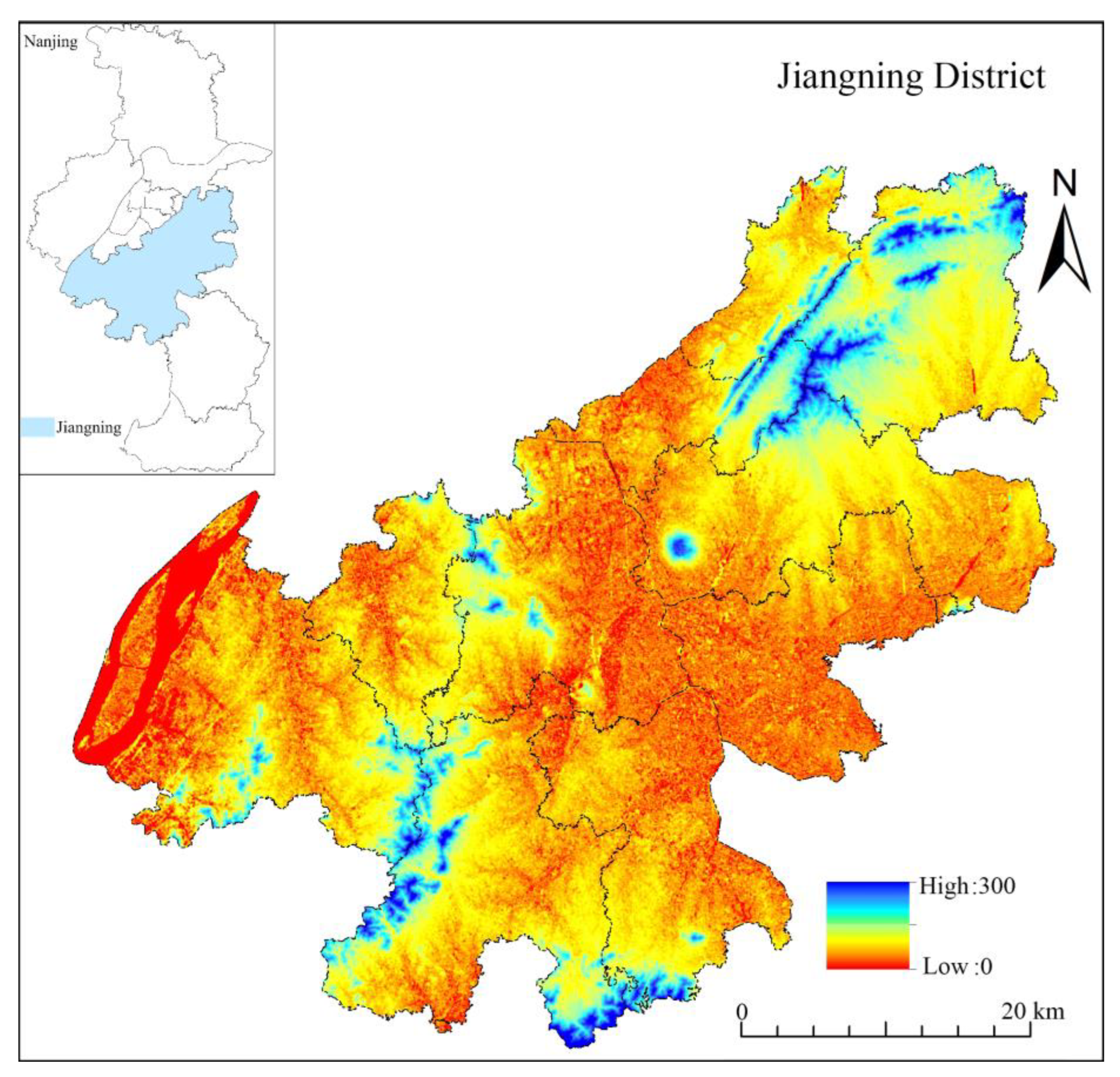
Rapid urbanization area is a regional concept, which is mainly used to judge the level of urbanization in an area through the urbanization rate (the proportion of urban population in the total population). The urbanization level in a rapid urbanization area exceeds 50%, and the annual growth rate of urbanization exceeds 1%. The process of urbanization in Jiangning District has been accelerating and has entered a stage of rapid development. Rural settlements are undergoing rapid evolution, which is typical of the changes of rural settlements in counties in rapidly urbanized areas. In view of this, this paper took Jiangning District in the Yangtze River Delta, using two remote sensing images (2010, 2020), and comprehensively used landscape pattern index, rank-scale law, and local hotspot detection model to explore the evolution characteristics of rural settlements in Jiangning District; a geographical detector was introduced to reveal the driving mechanism of settlement pattern evolution, in order to provide theoretical support for the spatial reconstruction of settlements in rapidly urbanized areas. The main aims of this paper are as follows:
What were the evolution characteristics of rural settlements pattern in rapidly urbanized areas? Based on multi-temporal remote sensing images, the characteristics of settlement spatial evolution in rapidly urbanized areas were analyzed from two different dimensions of scale and space distribution, by comprehensive use of landscape pattern index, rank-scale law, and local hotspot detection model.
What were the evolution-driving mechanisms of rural settlements pattern in rapidly urbanized areas? Natural environment, traffic conditions, and economic social factors were selected; a geographical-detector model was used to quantitatively reveal the leading factors of pattern evolution; and the driving mechanism of the settlement pattern evolution was elaborated.
4. Discussion
With the significant transformation from the planned economy to the market economy system and the rapid progress of urbanization and industrialization, the space of rural settlements has changed from the past “homogeneous and homogeneous” to “heterogeneous and heterogeneous”, and gradually tends to differential development paths and diversified development goals. In particular, in regions with high economic development level and rapid urbanization, the spatial elements, structure, and organizational relationship of rural settlements are changing rapidly. Rural settlements are also undergoing the transformation stage of optimizing the regional spatial pattern, restructuring the socio-economic form, and improving the functional layout. Taking Jiangning District as a typical case, this paper found that the patches area of rural settlement decreased by nearly half from 2010 to 2020, showing a trend of massive reduction, which indicated that rapid urbanization had an important impact on the evolution of rural settlement pattern, and caused a serious “squeeze” on rural space. The analysis conclusion was basically consistent with the research conclusions of Liu [
76], Li [
77], Lin [
78], and other scholars.
On the research of the mechanism of rural settlement pattern evolution, the current research [
79,
80,
81] has shown that the evolution process of rural settlements was comprehensively driven by multiple factors, and different factors show different characteristics as time and regional environment change. At present, many scholars [
82,
83,
84] believe that natural environmental factors played a fundamental role in the pattern formation of rural settlements in the early stage, and the natural environmental factors lasted for a long time due to less interference from other sources; socio-economic factors played an increasingly prominent role in the process of urbanization, and gradually became an important factor affecting the pattern of rural settlements. Using the geographical-detector model, this study confirmed that economic and social factors played a leading role in the evolution of rural settlement pattern in rapidly urbanized areas, and the role was becoming stronger, and the impact of natural environmental factors was diminishing.
Against the background of rapid urbanization, how to optimize and reconstruct the spatial pattern of rural settlements is a realistic proposition. Combined with the future evolution trend of rural settlements, and according to the implementation goals and requirements of rural vitalization, this paper tried to put forward the typical models of rural settlement spatial reconstruction in rapidly urbanized areas, namely, suburban integration type, agglomeration promotion type, characteristic protection type, and relocation and withdrawal type [
85,
86,
87,
88]. ① Suburban integration type refers to the suburbs near the city and the villages where the county seat Chengguan town is located, which have the advantages of becoming the back garden of the city, but also have the conditions of becoming part of the city. We will accelerate the integrated development of urban and rural industries, infrastructure connectivity, and joint contribution and sharing of public services, and gradually strengthen our capacity to serve urban development and carry out spillover of urban functions. ② Agglomeration promotion type refers to the existing large central villages and other general villages that will continue to exist, and orderly promote transformation and upgrading on the basis of the original scale, by activating the industry, optimizing the environment, protecting and preserving the rural style, and building a beautiful village suitable for living and business. ③ Characteristic protection type refers to villages with rich natural, historical, and cultural characteristics, such as famous historical and cultural villages, traditional villages, minority villages with characteristics, and famous landscape tourism villages. We should make reasonable use of characteristic village resources, develop rural tourism and characteristic industries, and form a benign mutual promotion mechanism between characteristic resource protection and village development. ④ Relocation and withdrawal type refers to villages located in areas with poor living conditions and a fragile ecological environment, villages that need to be relocated due to major construction projects, and villages with particularly severe population loss. The government has adopted such measures as poverty alleviation relocation, ecological livable relocation, and rural agglomeration and development relocation, and implemented village relocation and consolidation, so as to coordinate solutions to problems related to villagers’ livelihoods and ecological protection.
5. Conclusions
The paper took Jiangning District as a case study, comprehensively using the landscape pattern index, the rank-scale law, the local hot spot-detection model, and the geographical-detector model, and revealed the pattern evolution and driving mechanism of rural settlements in rapidly urbanized areas from 2010 to 2020. The following conclusions were obtained:
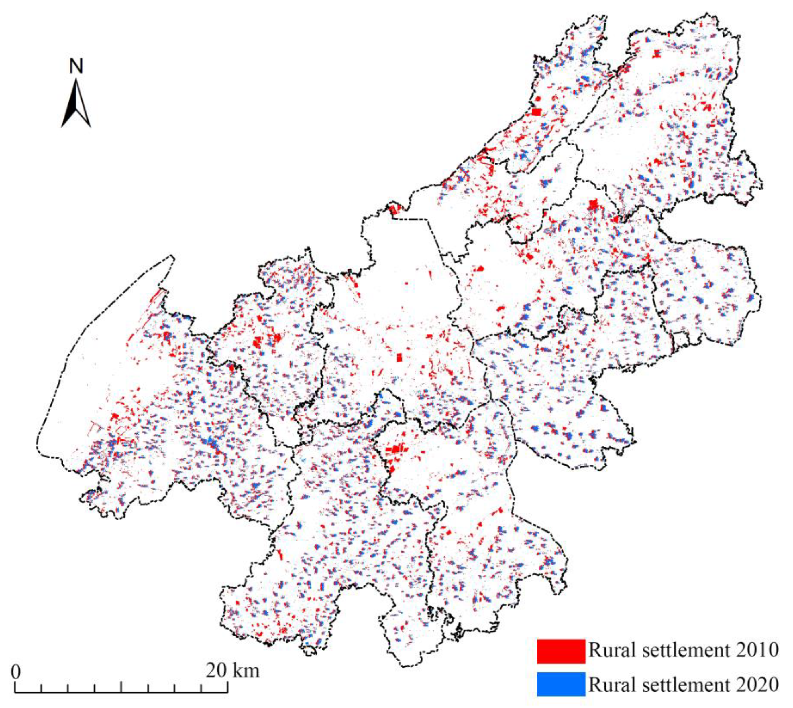
(1) The number of rural settlements showed a trend of large-scale reduction in Jiangning District, with the area of rural settlements reduced by 44.18% in recent 10 years. This shows that the pattern of rural settlements has undergone significant changes in the rapidly urbanized areas. The Zipf index of the settlements scale was less than 1 in Jiangning District in 2010 and 2020, indicating that the scale of rural settlements was generally well developed and the scale system of rural settlements was evenly distributed in the rapidly urbanized areas.
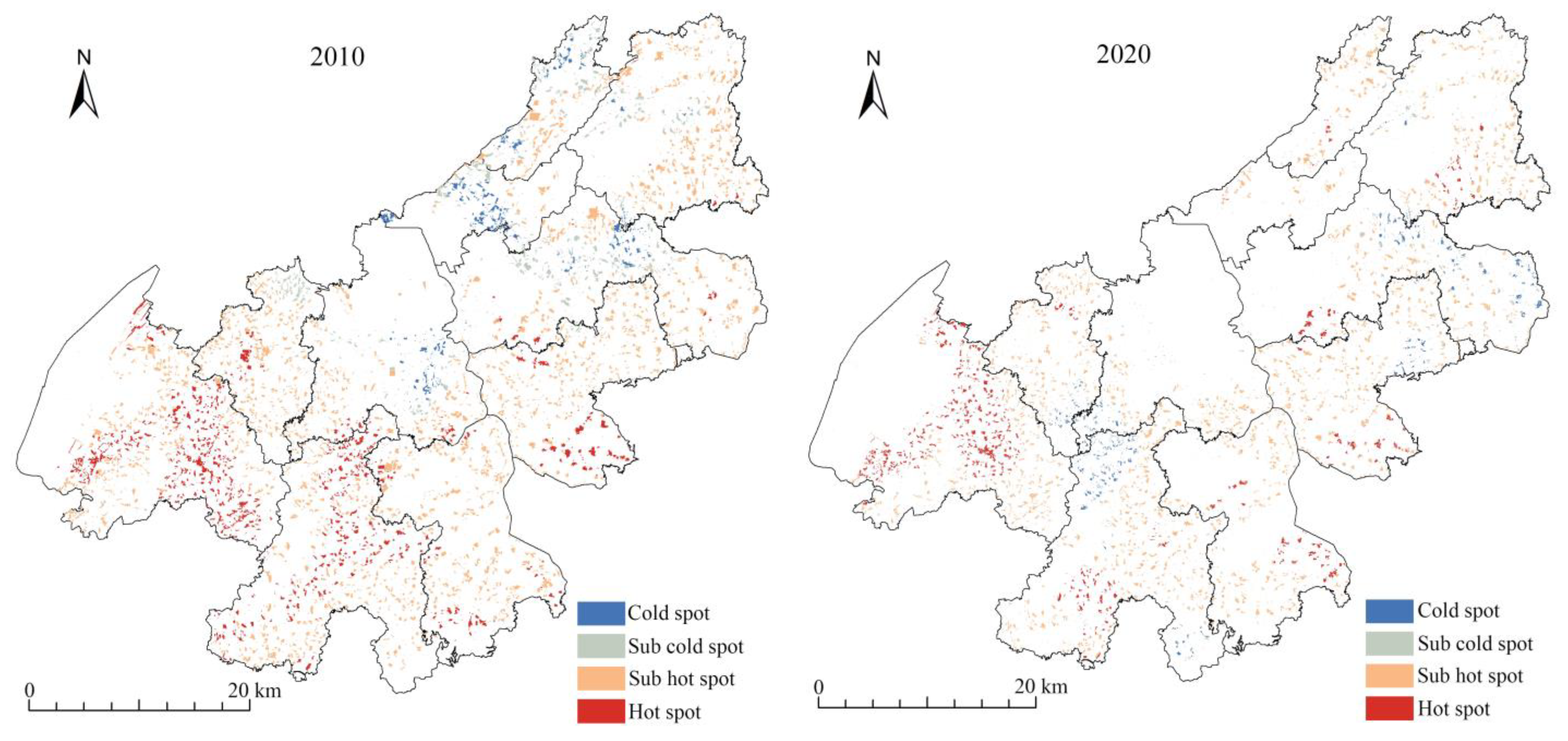
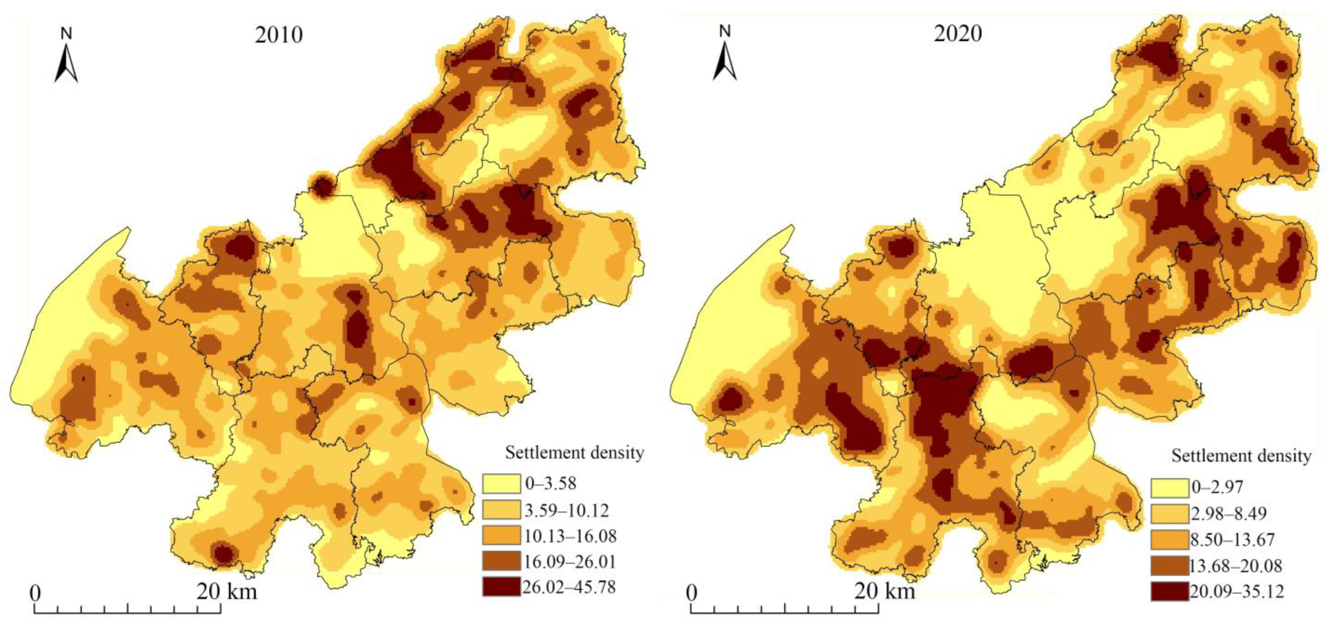
(2) The spatial distribution of rural settlements showed an “agglomeration” pattern in Jiangning District from 2010 to 2020, and the agglomeration trend was increasing. This showed that the distribution of rural settlements was closely related to human activities in the rapidly urbanized areas. The density distribution of rural settlements showed a “multi-core” center, and the distribution pattern gradually decreased from the center to the periphery in the rapidly urbanized areas.
(3) The evolution of rural settlement pattern was the result of the effects of geographical, traffic-accessibility, and socio-economic factors in the rapidly urbanized areas. Natural environmental factors such as terrain, water system, and cultivated land resources have shaped the spatial pattern of rural settlements, and their role has gradually weakened. Economic development, agricultural population, traffic conditions, and other socio-economic factors have played a leading role in the evolution of rural settlement pattern, and the interaction could enhance the impact on the evolution of rural settlement pattern.


