Article

Engagement with Urban Soils Part II: Starting Points for Sustainable Urban Planning Guidelines Derived from Maya Soil Connectivity

1
Faculté d’Architecture La Cambre Horta, Université Libre de Bruxelles, 1050 Bruxelles, Belgium
2
Facultad de Arquitectura, Universidad Autónoma de Yucatán, Mérida 97000, Mexico
3
School of Water, Energy and Environment, Cranfield University, Cranfield, Bedfordshire MK43 0AL, UK
4
Institute of Archaeology, University College London, London WC1H 0PY, UK
*
Author to whom correspondence should be addressed.
Land 2023, 12(4), 891; https://doi.org/10.3390/land12040891
Submission received: 3 March 2023 / Revised: 12 April 2023 / Accepted: 13 April 2023 / Published: 15 April 2023
(This article belongs to the Section Urban Contexts and Urban-Rural Interactions)

Abstract

:
Using the Precolumbian lowland Maya model of urban soil connectivity discussed in Part I, we review how soil connectivity can transition into urban planning policy and, by extension, could ultimately become codified as vantages and guidelines for urban design. In Maya agro-urban landscapes, the interspersion of open and green space with construction and paving provides edges (or interfaces) between sealed and unsealed soils at which the potential for soil connectivity manifests. These edges create an undeniable opportunity for urban planning to determine methods, guidelines, and conditions that can enhance soil connectivity. We argue that adequate attention to soils in urban sustainability goals would counteract misconceptions about the compact city paradigm and compensation for soil sealing in urban practice. Through preserving and increasing urban soil availability, proximity, and accessibility, advisory policies can stimulate shared values and everyday behaviours that reinforce the responsible and productive use of urban soils. Such urban planning can enable and encourage widespread participation in urban soil management. To promote policymaking on urban soils, we assess the importance and challenges of using urban green space as a proxy for the presence of urban soils. Our review suggests that urban green space offers high potential for use in urban planning to develop habit architectures that nurture soil-oriented pro-environmental behaviour. However, we also acknowledge the need for consistent and systematic data on urban soils that match sustainable urban development concepts to assist the effective transition of soil connectivity into urban planning codifications. Formulating adequate soil-oriented planning guidelines will require translating empirical insights into policy applications. To this end, we propose methods for enhancing our understanding and ability to monitor urban soil connectivity, including onsite surveys of land-use and bottom-up experience of soils, the mapping of the edges between sealed and unsealed soils, and using landscape ecological scales of analysis. In conclusion, we position soil care and connectivity as a primary task for urban planning and design and digest our findings and empirical vantages into concrete starting points devised as instruments to support urban planning in achieving soil codification.

1. Introduction

Weighty reports from the Food and Agriculture Organization [1] and Intergovernmental Panel on Climate Change [2] assert the pivotal role of soils in global ecosystemic functioning and the alarming state of land degradation. Urbanisation, and the associated needs of urban populations, drive agricultural practices and modes of production over the world to meet demands. Meeting these demands is largely responsible for accelerating soil erosion and diminishing soil quality at rates that significantly outpace soil formation [1,2,3,4,5,6]. The fundamental nature of contemporary urban environments characterised by high-density urban land cover is such that the soil dependency of urban populations remains concealed and distanced. Consequently, urban populations lack awareness of, engagement with, and concern for soils [7]. The absence and inadequate treatment of soils are also apparent in aspirational advisory urban policy [8,9], ultimately allowing the dissociation between urban life and its dependency on soils to deepen [10]. Despite the detrimental effects of preceding urban development, urban planning and design are essential for attaining urban soil sustainability (see [11]). Thanks to previous efforts identifying the archaeological manifestation of urban soil management, we can now build on the Precolumbian lowland Maya model of urban soil connectivity (i.e., soil–society relations, sensu McBratney et al. [12]). We will use the Maya model to equip urban planning to codify urban soil management into policy and design guidelines.
Evans et al. [7] review empirical archaeological evidence on diverse and intensive Maya soil management practices from urban design preserving space for soils to enhancing soil quality and approaches to soil protection as part of everyday urban life. Evans et al. end up formulating a range of questions urban planning should address in order to stimulate soil connectivity according to principles observed in lowland Maya urban centres. Vis et al. [10] use socio-cultural interpretations of Maya urban society to posit that supporting a culture of soil care should be a primary task for urban planning and design. Vis et al. recognise that how soil connectivity was supported through creating frequent and distributed opportunities for encounter and engagement with soils in Maya urban environments itself emerged from a broadly shared pro-environmental cultural attitude. We thus articulate that the Maya model of stimulating urban soil connectivity relied on three routes:
  • Encounter and engagement with soils;
  • Knowledge exchange for sharing and nurturing pro-environmental values;
  • Encouraging broad participation in productive human–environment relations.
The second and third routes are adapted from McBratney et al.’s [12] (p. 208) originally suggested routes for stimulating soil connectivity: (1) education and knowledge exchange with soil experts and managers; and (2) cultivating relationships between producers who work with soil resources and consumers of soil products. Adaptation is necessary because McBratney et al.’s [12] (see also [13]) suggested approach is precarious and risks limited impact while maintaining stakeholder divisions and attitudes that perpetuate the paradigm of reductive social-ecological relations responsible for unsustainable urban development [10].
Since present-day role models for stimulating the ‘new’ notion of urban soil connectivity are lacking, it is now key for urban planning and design to consider this archaeological model for urban soil connectivity. Critical appreciation of the mechanisms of Maya urban soil connectivity may permit the adjustment of policy guidelines and approaches accordingly, in order to set contemporary urban life on a trajectory towards soil security. Therefore, in Part II of our argument, we will consider how archaeological evidence can be used and translated into concrete starting points for urban planning and design to catalyse soil connectivity. This crucial step reifies the purpose of ‘applied archaeology’ [14,15], which is to utilise archaeological knowledge to address developmental challenges perceived in the present. Such starting points extend our concern for soil connectivity into the codification dimension of soil security.
McBratney et al. [12] conceptualised five dimensions of soil security: capability, condition, capital, codification, and connectivity. Scholarly attention informing each of these dimensions in urban contexts has not been equally weighted. The enhancement of soil condition in urban environments has been thoroughly studied (see [13,16,17,18]), as has boosting soil capability and soil capital (see [19,20,21]). In 2014, McBratney et al. [12] argued that soil connectivity had been under-researched, which, we assert, is still valid today. Using Evans et al. [7] and Vis et al. [10] efforts to substantiate and understand the dynamics of soil connectivity in urban society in practice, we can start to address how these insights can be transferred to the realm of policy. Successful adoption of soil connectivity stimuli into planning policy would expand previous attention given to urban soil codification that targets aspects of soil quality evaluation (see [22,23]) and compensation of soil sealing (see [11]). Thus, we subscribe to the idea that “protecting the soil […] is no longer sufficient to describe the deep paradigm shift necessary to enter the urban and ecological transition from the soil side and to understand the actual complexity of the relation between soil and urbanisation” [24] (p. 53).
In order to facilitate the transition of soil connectivity into urban planning policy and, by extension, vantages and guidelines for urban design, we will first revisit insights into how soil connectivity is manifest in urban environments following on from Evans et al.’s [7] thesis of the availability, proximity, and accessibility of soils in lowland Maya agro-urban landscapes. This is significant for two main reasons. First, the existence of the Maya model of urban soil connectivity demonstrates that “[r] esolving the land-use paradox […] is […] an indisputable urban design challenge” [7] (p. 2). Second, considering how soil connectivity is stimulated by urban form and spatial configurations identifies the kind of information urban planning will minimally require in order to formulate guidelines and monitor their implementation. The inadequate treatment of soil management in planning policy advice and sustainability aspirations is due to perceiving urban development as solely a threat to soil security. The next step involves recognising that this situation neglects to appreciate that urban planning and design are key to achieving sustainable urban soil resources [11]. Therefore, we review how the lowland Maya model of soil connectivity, broadly carried and enacted in urban life, suggests opportunities for planning urban soil connectivity. Subsequently, we offer a critical assessment of the challenge of obtaining information on accessible urban soils in contemporary urban environments, proposing data on urban green space as an imperfect first-stage proxy. We then discuss several recent methodological developments which could be adapted to approach and assemble information on urban soils and soil connectivity that is more accurate and has greater utility than currently available data. We will conclude by offering up a list of concrete starting points, conceived as conceptually informed targets and leverage points as well as empirical vantages and methods, to support and guide the development of urban planning and codification of soil in policies that promote soil connectivity.

2. Soil Connectivity in Urban Environments

The challenges and principles for achieving urban soil security are fundamentally the same as those that govern the role of soils in global sustainable development [12]. Soil sealing, habitat fragmentation, and reduced access to, or depletion of, the local stock of soils are among the effects that result from increasing urbanisation and intensive development, which highlight the urban land-use paradox that more land is needed to house people, yet more land is also needed to sustain them [7]. Exactly in geographies where populations concentrate (i.e., cities and urban landscapes), the soils theoretically capable of contributing to the local sustenance of that population are sealed, maltreated, or diminished by physical construction and socio-economic conflicts of interests.
Alternatively, empirical evidence shows the pervasive soil presence in tropical lowland Maya urban environments making the everyday experience of, and engagement with, soils inevitable [7]. Such urban environments not only enable but also encourage soil management routines by making their utility and necessity apparent. The adoption of soil management behaviours in Maya urban life is indicative of the presence of socio-cultural mechanisms that reinforce knowledge exchange, such as rituals that maintain shared values around human–environment relationships and engagement with cultural narratives and calendar cycles related to agricultural production. The existence of productive soil–society relationships reveals widely carried participatory attitudes among the Maya area as producers and consumers of soil products [10]. This underlines a dialectic generative process between socio-cultural values and behaviours and the physical environment (see also Section 3.1). In this second part of our diptych, we, therefore, revisit our insights into how soil connectivity manifests in urban environments to elucidate the urban design challenge confronting decision makers, which urban planning should guide and identify the types of information that will assist in formulating soil-oriented planning. Which Maya principles can urban planning and design observe to generate public awareness of soil benefits and to promote habitual pro-environmental social practices that are inclusive of urban soils?
It stands to reason that environments with the greatest potential to involve a large proportion of inhabitants in habitual soil connectivity in their everyday lives are structured by configurations in which access to, or the presence of, soils is frequently interrupted by spaces reserved for other social (including economic and cultural) activity. Quotidian soil connectivity is then permitted to arise from encounters and interactions facilitated by how the edges connect sealed soil areas into the urban system. Having an urban development or planning principle focusing on the instrumental position of edges would correspond with the connectivity characteristics of Maya agro-urban landscapes. Tropical lowland Maya urbanism is characterised by the relative dispersal of structures and groundworks over the landscape, which is interpreted as the incorporation of a high degree of open and green space in its built environment configurations [25,26,27,28,29,30] (but see Pugh and Rice [31] for an atypical example in which open space consignment to the urban hinterlands is preferred). Maya urban environments make space for soils through settling practices that demonstrate a concern with maintaining and enhancing the availability, proximity, and accessibility of soils [7] (see Figure 1). The utility of the dimensions of areas of soil as available, proximal, and accessible is dependent on how the edges of unsealed soil areas are shaped by physical and configurational characteristics in the design of the built environment (cf. [32], and Vis [33] (pp. 96–120) on constituting built environments with boundaries).
Assisted by soil science, Robin [34] demonstrates that the Maya household is constituted by the activities taking place between buildings, thus emphasising the connectivity of interior and exterior spaces. Encounters and interactions with soils enabled across the edges of sealed soil areas could range from deliberate cultivation and soil management strategies to the inevitable material decay of the built environment and waste deposition practices [7,35,36,37]. Waste, material discard, and decay of the built environment offer relatively untapped potential for contributions to the dimensions of soil capacity, condition, and capital [12]. The current urban practice appears to favour final deposition (i.e., landfill), while sustainable development goals emphasise waste minimisation and recycling, thus missing opportunities to engage with soil maintenance and intergenerational soil renewal [10,37].
Grauer [38] conducted a detailed investigation of activities taking place along the edges of small-scale karst depressions (pocket bajos) in the Maya city of Aventura (Belize). The spatial configuration of basic land-use elements at Aventura illustrates the integration of soil resources as proximal to residential units. “Every pocket bajo mapped at Aventura has between 1 and 3 mounds [ruins of architectural construction] within 5 meters of its edge”, and 20 percent of construction remained within 20 meters [38] (p. 84). Grauer’s analysis of material evidence marks the spaces in between and along the pocket bajos’ edges as locations of rituals underlining the meaningful engagement and physical interconnection of inhabitants with their environment (including water and soils) and their ancestors. The case of Aventura explicitly aids us in articulating that it is in how spatial design shapes the edges of sealed soil areas that urban planning can create an opportunity for habitual soil connectivity. The spatial design ultimately determines where and to what extent unsealed soils are present and can be perceived, encountered, or accessed in the urban environment.
Figure 1. A section of Chunchucmil (Mexico) demonstrating the spatial arrangement of architecture and garden areas and the frequency and complexity of edges to areas without soil (i.e., bedrock) (source: [35], reprinted with permission from Scott Hutson).
Land 12 00891 g001
Comprehending the variety and lineage of the edges of sealed soil areas in historical urban environments would require concerted comparative mapping efforts to facilitate quantitative analyses and qualitative interpretations. A frequent obstructing factor in such efforts is the compromised nature, consistency, and, above all, availability of physical evidence distinguishing built, paved, and unpaved areas (e.g., exposing bedrock) from areas in which historical soil cover can be identified. In the Maya area, typical topographical surface surveys or airborne Light Detection and Ranging (LiDAR) would not readily permit such land-use distinctions (cf. [39]). Although some soil cover can be inferred from topographical surveys or historical maps, reliable results in most cases would depend on excavation (exemplified by the Maya area [35,40,41,42,43]) or direct historical accounts (cf. [44], Figure 155). Stimulating this direction of investigation, the growing attention to the conceptualisation and significance of urban open space, its differentiation and integration, in historical contexts is welcome [33,45,46,47,48]. Such research sets an important step towards the more useful distinction of green and grey open space (esp. [46]), which, in turn, better equips inference of paved, unpaved, and soil-covered areas.
Urban green space suggests the likely presence of some urban soils. However, urban green space classifications conceal considerable variety in actual land use, green space characteristics, and differences in access, such as location and containment within other exclusionary specialised land uses (e.g., industry) or distinguishing public from private space (e.g., [49,50]). Simultaneously there are unresolved challenges in the mapping and classification of urban green space using remote sensing imagery, which plays a determinant role in global data availability on urban green space (e.g., [51,52,53]). Confused and uncertain classifications of urban green space also hamper effective planning towards SDG indicator 11.7.1 on open space provision.
It is readily acknowledged that, in broad terms, green space used for physical recreation is seen to involve less intensive soil engagement than the active cultivation of urban green space. For example, McElwee [54] explains that the intensive soil management required for sporting activities goes largely unnoticed, whereas gardening is the outdoor activity that is commonly seen to involve working soil with associated well-being benefits. Nicholls et al. [55] indicate that soil maintenance practices as part of urban and peri-urban agriculture (UPA) contribute to soil quality, soil formation, and sustainable food production (Evans et al. [7] demonstrate the same for lowland Maya urbanism). Reporting on the results of the project Our Common Soil, Barcelloni Corte and Boivin [56] and Viganò and Guenat [24] offer a conceptual reframing of urban soils as ‘living soils’ that stresses the mutability of soil qualities and functionality through human (and planning) interventions. By applying a landscape approach to consider agricultural and urban soils in combination as ‘rurban’ soils, these authors show the wide potential for achieving both ecological and urban living benefits through integrative pro-active soil management. Dehaene and Vandermaelen [57] argue that in order to place soil centrally in urban planning, it needs to start taking care of the soil caretaker. For them, this implies that urban planning needs to look beyond the bounds of the urban built environment where “we find not only traditional and residual soil care practices, but also perspectives to question our own discipline, and communities of practice that can assist us in coming up with distinctive ideas and an accompanying paradigm” [57] (p. 51). It is clear from the Maya model of soil connectivity that planning should not only humbly process input from rural or smallholder farmers, but it must also consider the expertise and participation of all soil caretakers in maintaining productive relationships with soils.
Notwithstanding the difficulties with consistent data availability and meaningful classifications of green space and their actual use, an adaptation of innovative urban morphological mapping methods (e.g., [33,58] on Boundary Line Type (BLT) Mapping; [59]) and their combination with landscape ecology (cf. [60]) would permit the identification of the edges between sealed and unsealed urban soils (Figure 2 illustrates this empirical opportunity). Taking a cue from BLT Mapping, subsequent comparative analyses could differentiate the variety of social and material properties these edges comprise, where variety in properties indicates qualitative differences in habitual soil connectivity opportunities in the urban built environment. Furthermore, systematic edge mapping would enable the study of the lineage of their occurrence and performative roles throughout the development of urban built environment configurations (e.g., in densification and land cover intensification processes).
Effective application of analytical mapping of such urban soil–society interfaces first requires the resolution of respective contemporary, historical, and archaeological challenges in mapping differentiations of urban open space with accuracy and precision. If resolved, the topographically detailed land-use categories produced need to be reconciled across those disciplines in order to facilitate consistent appreciation of the presence and access to urban soils through time and across urban societies. That we feel confident to speak of a Maya model of urban soil connectivity is partially derived from our incomprehensive synthesis of data on agro-urban landscape characteristics. Instances of lowland Maya agro-urban landscapes display consistency in the relationships of built-to-open space over an extensive and diverse region. From the evidence for deliberate soil enhancement, it can be deduced that a notion of soil connectivity played at least a co-determinant role in the development of their urban environments [7]. This consistency is a strong indicator of long-term shared cultural values, common practices, rituals and ceremonies, and periodic knowledge exchange that support the incorporation and management of soil presence and its associated benefits in urban environments [10]. Our work in Part I [10] leads to the insight that we should adjust how we envision urban societal stakeholder groups and their roles in soil connectivity. Therefore, in how we assess transferring archaeological insights into opportunities for planning urban soil connectivity, we aim to demonstrate ways of facilitating broad participation in productive soil–society relations and to fortify urban decision makers as essential enablers of this goal. With that premise, we will now explore where and how urban planning and design interventions can begin to promote and enhance opportunities for everyday soil encounters and engagement. Such frequent enactments of commonplace soil connectivity will enable and support urban stakeholders in securing urban soils as an intergenerational resource.

3. Translating Maya Practices into Starting Points for Urban Planning

3.1. Opportunities for Planning Urban Soil Connectivity

In Part I [10], we address the need to counter the absence or subsumed position of soils in aspirational planning advisories to achieve global ambitions for urban sustainability and the associated planning commitments of the New Urban Agenda (NUA) [9]. The perhaps unsurprising effect of general goals targeting sustainability and global advisory planning is that the treatment of soils in local planning policies of individual cities globally remains uneven and imbalanced [61]. Teixeira da Silva et al. analyse seven urban plans adopted from 2007 to 2016 by metropolitan areas across the world with populations of over 2 million. It is worth reiterating what they surmise on the role of soils in these plans [61] (p. 1094): “While most plans frequently used words such as ‘‘food’’, ‘‘land’’ and ‘‘water’’, soil functions are not addressed equally in the plans. Even though there are some goals in the plans to increase local food production, no direct link between soil functions and ‘‘food’’ is established”.
In spite of the general absence of soil in local planning policies, Peleman et al. [11] assert that where soils do receive explicit consideration, the focus is on a flawed logic of compensating for (intra-city) soil sealing. Indeed, the subsumption of soil as a critical aspect of sustainability goals associated with land leads to an inadequate unpacking of soil’s essential position in land-use competition arising from urban development strategies set out in advisory policy documents such as the EU’s No Net Land Take by 2050 [8] and NUA [9]. The impoverished understanding of urban soils’ ecological functions (e.g., [62]) means these documents risk encouraging a simplified implementation of supposed sustainable urban development outlined by the compact city paradigm ([63], relatively high residential density with mixed land uses requiring less per capita infrastructure as contrasted to mechanised transport reliant urban sprawl).
Halting and reversing the negative effects of the trajectory of increasing urban soil sealing is predominantly the purview of urban municipalities and local authorities. Their policies set out the lines for how major urban land-use categories are planned and implemented. Dehaene and Vandermaelen [57] (p. 45) use agroecology to expose the compact city fallacy. Permitting progressive urban soil sealing in already urbanised areas banishes accessible soils from our cities, allowing the dissociation between urban life and its soil dependency to deepen. As Peleman et al. [11] (p. 8) state: soil sealing policies that permit infill and thus the removal of soils and their accessibility “uncritically [consider] the last reserves of open land as worthless because they have already been ‘compromised’ by the urban fabric that surrounds them.” Dehaene and Vandermaelen [57] further point out that by concentrating populations in urban centres, our ability to care for soils in surrounding rural and peri-urban areas becomes less feasible. The landscapes within which the majority of soils are positioned need to remain populated and vibrant themselves. This reasoning highlights our Part I [10] vantage that because people concentrate in urban areas, these also offer the greatest potential for the highest intensity of soil–society relationships. Therefore, methods, guidelines, and conditions determined by urban planning policies can enhance soil connectivity to achieve urban soil security. The initial formulation of (locally or regionally) adequate planning guidelines requires translating empirical insights into policy applications and understanding the lived experience of urban environments. Successful planning policy also requires methods for scientific observation and monitoring of urban soils and soil–society relations (Evans et al. [7] (p. 13) list essential questions to address in order to stimulate soil connectivity that arises from Maya evidence). Furthermore, the effectiveness of planning depends on the power and means of the authority to enforce correct implementation.
The archaeology of Maya urban life shows the resilience and social-ecological benefits of a culture in which urban practices value productive human–environment relationships among diverse, multi-ethnic populations. Likewise, in current urban societies all across the world, cultures, worldviews, beliefs, and lifestyle preferences mix, while the recognised urgency of environmental threats and the unsustainability of our highly consumptive urban lives hold increasing public sway. Maya evidence thus reveals an opportunity for urban policy and practice to arrange pro-environmental behaviour by instating unifying values and dispositions in order to constitute regionally appropriate versions of cosmopolitan (cf. ‘rooted cosmopolitanism’, sensu Appiah) urban culture. We should take this opportunity to employ planning processes and urban design to place environmental relations at the heart of regional cultures, cutting across the multifarious inclinations of globalised urban life.
Pre-existing role models can prove more persuasive than prescriptive policies and more accessible than scientific principles in isolation to inspire urban populations to act. Insights from lowland Maya urbanism may serve as pathways towards restoring and awakening a collective appreciation of soil dependence and soil benefits among urban inhabitants. The mobilisation of a broad societal contingent as an urban stakeholder category to stimulate and sustain soil connectivity depends on establishing a generative dialectic of two crucial elements in urban life:
(1)
Converting public awareness of environmental threats, and the reported willingness to undertake environmental care, into shared values and quotidian behaviours that reinforce the responsible and productive use of soil as an intergenerational resource;
(2)
Enabling and encouraging wide participation in urban soil management by preserving and increasing urban soil availability, proximity, and accessibility to promote everyday encounters and durable conscious engagement with soils.
The nature of archaeological evidence prevents unequivocal direct arguments from asserting the existence and implementation of urban planning policies in Maya urban landscapes (for discussion, see [31,64]). While large-scale infrastructure and civil engineering, as well as the construction and periodic redesign of major monumental complexes and urban scenes, required planning strategies (see [65]), it is ambiguous whether the layout and positioning of residential units and neighbourhoods were equally subject to coordination (e.g., [66]; cf. [67] on the relating circulation and visibility to the distribution of infrastructure, resource access, and land subdivision). Archaeological evidence predominantly provides insights into the outcomes of urban practices. The spatial and architectural implementation of Maya urban farmsteads in the course of developing urban contexts would at least have been subject to informal or community-based consent. Such an urban practice strongly aligns with bottom-up motivations to act, for which the Maya supplied socio-cultural values and spatial opportunity as derived from a profoundly engaged social-ecological perspective on human–environment relations. Today’s agents of urban development are permitted to act on the environment predominantly through ownership structures determined by a mechanistic or deterministic worldview (cf. [68]). Masterplans and visions put down ambitions for urban development and typically include zonation of ascribed land-use categories. These plans predetermine which kind of material change of state is permitted to support future land use, with the objective of balancing the competing values and priority interests of development agents and stakeholders.
Urban planning policies govern the involvement of most stakeholder groups with urban soil, and so determine respective stakeholder needs for soil information (cf. stakeholders discussed by Siebe et al. [69]). On the other hand, Linder et al. [70] confront the pertinence of nurturing pro-environmental habits. Habits are routinised daily behavioural patterns which occur without further reflection. Linder et al. position habits as essential components for a holistic understanding of pro-environmental attitudes and sustainable behaviours. They argue the importance of understanding leverage points that permit habits to emerge. Since 40% of daily behaviours are performed without deliberation, we should invest in creating conditions that transform attitudes and intentional behaviour into environmentally beneficial habits. Building on the concept of ‘habit architecture’, they explain that the social and physical environment set boundary conditions that can support or discourage specific behaviours (sometimes even overpower intentions). Resonating well-established time-geographical notions of restricting and enabling time–space resources [71,72,73], Linder et al. [70] (p. 7) write: “Physical and social environmental conditions motivate and constrain actions through the range of behaviours they allow and enable. In order for any habit to develop, the possibility for that habit needs to be provided by the surrounding context.”
Lowland Maya urban environments provided the means and opportunity for everyday soil encounters and engagement (see [7,10]). Such behavioural patterns were reinforced through a shared culture of enacting the value of holistic human–environment relationships (humans and environments as mutually constitutive). Participation in ceremonies and everyday rituals as part of urban life routinely unified cultural beliefs with practical utility. It is straightforward to frame Maya archaeological evidence as evidence of cumulative pro-environmental and soil-oriented habits. These habits sit alongside some intentional behaviours, which were supported and reinforced on daily and periodical bases by both their social and physical environments and societal knowledge interwoven with cultivation cycles. Maya urbanism thus demonstrates the potential of ‘habit architecture’ in fostering a regional pro-environmental urban culture.
Our insights into bottom-up soil engagement practices derived from Maya evidence stand at odds with prevalent top-down contemporary urban planning instruments. How urban soil interests are determined by top-down planners may not match what it takes to inspire individuals to enact beneficial soil–society relationships. According to Teixeira da Silva et al. [61], better applications of soil science in urban planning would connect different stakeholders to distinct categories of urban soil benefits or services. Our inevitable and urgent recommendation is for urban planning—comprising urban planning research, local and global urban planning policies, advisories, awarding accolades (e.g., European Green Capital), and agendas such as NUA [9]—to acknowledge the fundamental dependency of urban society on soils explicitly.
Upon elucidating urban society’s fundamental dependency on soils, urban planning should concentrate on enabling urban soil stakeholders to connect to aspects of the versatile utility and foundational ecological value of urban soils. When urban planning and design provide both durable spatial means (how urban land use is allocated, shaped, divided, and adaptable) and socio-cultural reinforcement of human–environment relations, the long-term management and spatial development of intergenerational (sustainable) urban environmental resources may be within reach. To support this mission, it becomes prudent to consider how urban planning can approach primary target locations of urban soils for stimulating soil connectivity and how we can equip urban planning with appropriate information for promoting soil connectivity.

3.2. Urban Green Space as Soil Locations

In urban green spaces, the presence and benefits of soils are implicit. Growing planning and design interest in urban green space thus offer a chance to foreground soils. We previously discussed that the mapping of and information on the usage of urban green space is often ambiguous, if not ineffective. There is no consistent agreement on how to categorise or measure urban green space, and the green space classification often subsumes a number of different functional land uses [49,50,51]. In policy resulting from SDG target 11.7, the treatment of green space remains indiscriminate from public and open space. Remote sensing techniques typically produce inadequate data for proper monitoring of incremental changes that diminish urban green space as a resource for sustainable development [74]. “[U]rban planners need to have information about soils, not only of their mechanical properties, but also about the distribution of soils and landforms in the city and its surroundings” [69] (p. 355). Based on insights derived from lowland Maya urbanism, we argue that improved implementation of urban soil (and associated green space) monitoring still falls well short of planning for soil connectivity. That is, monitoring alone does not provide the insights and information that enable soil-oriented nature-based solutions (executing development using natural attributes) [75] to guide the design of spatial land-use configurations.
The value of green space in the attainment of urban sustainability is increasingly recognised, but certain aspects of urban green space receive much more attention than others. Their potential for food production (e.g., [4,25,26,55,76,77,78,79]) and managing or increasing urban biodiversity (e.g., [80,81,82,83,84,85]) are amongst the most frequently referenced [86]. In reality, the benefits of green space and its usage for urban sustainability are often interconnected. Nicholls et al. [55] highlight that practising polyculture in small urban plots enhances productivity and that small-scale urban agriculture supports soil quality. The advantages of small-scale engagement confirm that the present-day adoption of soil management practises for urban cultivation derived from Maya urban landscapes has the potential for urban soil sustainability (see [7,10]). A further interesting development concerns the detected correlation between (the perception of) urban green space biodiversity and positive impacts on health and well-being [87,88,89,90] (for soil biodiversity in particular, see [62]). Vis-à-vis the patterns of urban land cover in the global south, Drescher [76] observes the potential of unsealed soil areas in urban environments to enable food production and waste (water) management. In their summary of recent urban case studies on soil-related ecosystem services, Teixeira da Silva et al. [61] (pp. 1095–1098) note that attention focuses on soil productivity in urban environments, whereas aspects such as lifecycle maintenance and the representation of cultural values, meaning, and heritage remain underdeveloped (but see [37]).
Considering the location of green space among population concentrations, regular use for socio-cultural (community) activities is inevitable. This makes urban green space a high-potential location and resource for establishing a habit architecture that nurtures pro-environmental behaviour (sensu Linder et al. [70]). There are concerns, however, about uneven access and how usage correlates with urban socio-economic inequality, as associated with metric distance to residential locations, connectedness in the urban network, and quality of urban green space (e.g., [91,92], cf. [93]) as well as the need to match the intended purpose of the space to the functionality required by the community [87]. As such, not everyone benefits equally from the social, health, recreational, and economic services—including land value increases and overall attractiveness—that urban green space provides alongside its ecological function and sustainability potential.
Underutilisation owing to reduced accessibility or negative impacts on attractiveness and safety contributes to the pressure on urban green space from land-use competition. Colding et al. [74] (pp. 3–5) identify an additional five drivers of incremental loss of public urban green space, which tends to go largely unnoticed by urban inhabitants:
(1)
Lack of financial support, often leading to land-use change and privatisation;
(2)
Separation of attributes, which means that green spaces are split up to serve specific functions, often as a result of cost-saving measures or conflict mitigation;
(3)
Increasing private control and infrastructural safety measures, which means monitoring and policing that may restrict access or impact ecological properties, privacy, and attractiveness, reducing social use of public green space;
(4)
Congestion or direct over-use, which can make transaction or governance costs excessive (e.g., crowding, access capacity, conflicts between users);
(5)
Activity intensification, often as a result of proximal population densification, where combining different functions in the same space, or improving efficiency for a single use of space, compromise the quality of environmental resources and sustainability aspirations.
Alarmingly, Colding et al. argue that cumulative incremental change leads to baseline shifts (adapted from Pauly [94]; see [95] (pp. 6–7) in the experience of urban nature, recognised by psychologists (see [96,97]), “where each generation of humans tends to take the current condition of an ecosystem as the nondegraded state” [74] (p. 6). Over time well-intended small decisions incur gradual land-use change causing loss of ecological qualities, opportunity, and experience. Such processes of incremental change thus emerge as a key cause of Pyle’s ‘extinction of experience’ (referenced by [98]) and the dissociation between urban life and its soil dependency. The consequences for the long-term management of intergenerational resources, such as the availability and accessibility of urban soils, are detrimental.
Enabling top-down urban planning policies to maintain and create spatial opportunities for soil connectivity requires agreement on the social-ecological value of urban soils and their association with functional categories of urban green space. Only with such an agreement will it be possible to measure, map, and analyse the spatial morphological properties of extant urban soil resources effectively, including where urban green space signals the presence of healthy urban soils.

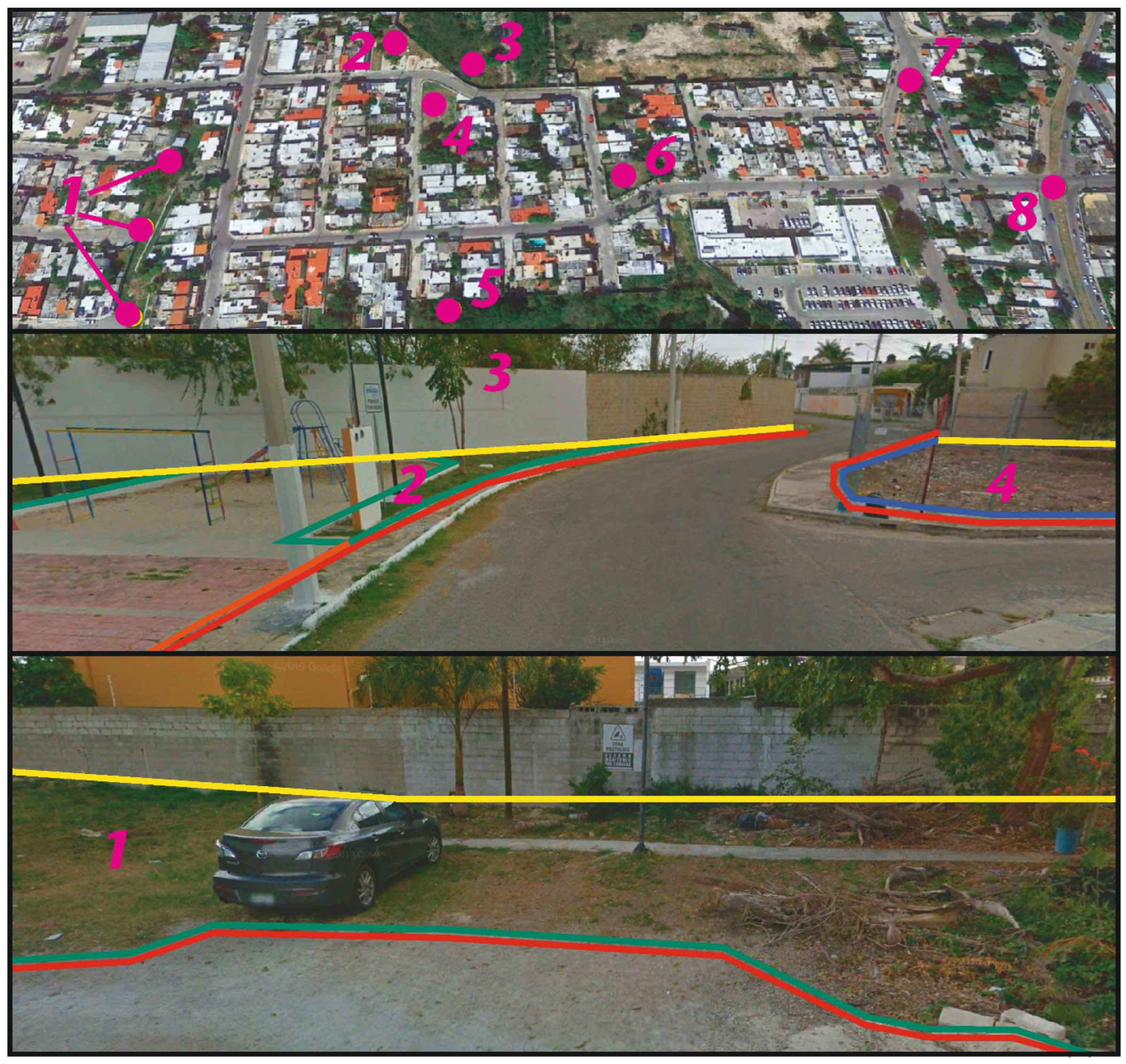
3.3. Methods to Aid Urban Planning in Analysing and Assessing Urban Soil Connectivity

So long as the quality of mapping urban green space is restricted by technical limitations in remote sensing and computation, we may need to invest more research efforts into onsite urban surveys in the interim. Next to ascribed spatial categorisation, an adaptation of respondent-based geocoding methodology may offer opportunities to add bottom-up spatial definition to urban soil presence and encounters [99]. Samuelsson et al. [99] used a public participatory GIS (PPGIS) to record the perception of opportunity and emotive response to urban environment attributes. Similarly, detailed attention to the mapping and analysis of the spatial-material characteristics of the interfaces between sealed soil and unsealed soil areas would enable an urban design-oriented appreciation of soil connectivity opportunities. Such appreciation of designed properties stimulating soil connectivity requires urban morphological mapping to pay particular attention to how the boundaries and connections between spaces with ecologically distinct surface characteristics are shaped. To this end, Boundary Line Type (BLT) Mapping [33,58] provides a useful conceptual and methodological blueprint for mapping and comparing boundaries in urban built environments.
Planning the spatial allocation of unsealed soils and the edges of sealed soil areas (Figure 2) should adhere to the logic of ‘ecology of urban ecosystems’ and avoid marginalising soil presence through ‘ecology in urban ecosystems’ (difference elaborated by Picket et al. [83]; cf. [62]). The interplay of sealed and unsealed areas should be considered as a component of building connectedness and corridors that support viable habitat matrices, contribute to soils, enhance soil quality, and mitigate the negative effects of soil fragmentation. Thinking about how patches of landscape ecological properties link up chimes with a functional network approach to urban green space. Rather than the easy application of metric buffers to approximate the accessibility of urban green spaces, network analyses better match the principle of access resulting from moving through the urban environment and its correlation to usage [91].
Marcus and Berghauser Pont [60] (p. 1) recognise the potential to “integrate essential concepts in landscape ecology such as patches, matrix and fragmentation […] with essential variables in urban morphology such as distance, density and diversity.” Their work subsequently suggests that the urban built environment could be considered a landscape ecological matrix. Simultaneously, this landscape ecological scale of analysis would appear more appropriate for approaching cities, or urban life, as a social-ecological system [100,101]. We note that a landscape approach to sustainable urban development better corresponds to the concept of Maya agro-urban landscapes [29,102] and better accommodates the holistic human–environment relationship values found in Maya society [30,38]. In general, we stress that there are various opportunities to bring urban morphological sophistication to the analysis of urban soils. Such methods would help planners to monitor patterns of change in the presence and accessibility of urban soils over time and to understand how the urban built environment can facilitate soil connectivity.
Differences in the units of quantification between urban soil studies and the lack of (quantifiable) data, e.g., cultural use-benefits, obstruct the formulation of concrete indicators that would enable the effective monitoring of how urban soils support or deliver specific benefits [61]. The lack of consistent and systematic quantitative data that match sustainable urban development concepts is by no means a challenge unique to understanding cities in history and archaeology (cf. [103]). We believe there is significant methodological development to undertake to establish stable units of (quantitative) measurement and (qualitative) assessment that enable appropriate mapping and analysis of urban soil presence and connectivity. The problem of generating and formatting appropriate information stands in the way of formulating spatially explicit planning principles and guidelines. Consequently, here we resort to signposting several methodological routes capable of addressing crucial aspects of this problem. When appropriate analytical units are fully operational and have been applied over suitable varieties of case studies, such detailed empirical knowledge can start informing nature-based solutions in which environmental, social, and built components all play a constitutive role [83,104]. We stress the importance of formulating spatially explicit sustainable urban planning policies for two simple reasons:
(1)
The promotion of pro-environmental habits, including dedicated attention to soil engagement;
(2)
The fact that urban expansion resulting from global urbanisation processes is a challenge that can only be tackled through creative interdisciplinary design thinking.
The requirement for spatially explicit urban planning for soil engagement leaves us to illustrate the power of Maya urban archaeological insights to inspire creative urban design responses. Vis et al. [105] reported on the cross-sectoral urban design ideas competition Dust to Dust: Redesigning urban life in healthy soils and the co-productive process of developing winning entries via a charrette into a public exhibition at the renowned Sainsbury Centre for Visual Arts (SCVA), Norwich, UK. The competition used lowland Maya urbanism as a source of inspiration to set brief requesting urban designs that put soils first.
In the Dust to Dust exhibition, the space opened with a display that visualised urban soil properties resulting from a number of contexts that are frequently encountered in regional urban environments (Figure 3). An introduction was then provided on the importance of soils in the spatial patterns of Maya urban landscapes. The soil display and introduction contextualised the presentation of the contemporary site-based urban design concepts and generative design principles devised by the six winning multidisciplinary teams, all of which addressed sustainable urban development challenges. The Dust to Dust competition and exhibition demonstrate how urban soil knowledge can be enhanced, disseminated, and translated to find ways to promote soil connectivity by creating conducive environmental conditions. Maya archaeology provided an evidence- and insight-base and source of inspiration for sustainable urban design responses. Soil specialists collaborated with other (urban design and planning) stakeholders to offer potential holistic solutions for negotiating conflicting land-use interests and developing habit architectures. The results communicated the significance of the links between urban design, cultural values and habitual soil engagement, and soil quality for achieving urban soil security to a general audience. Finally, all multidisciplinary design ideas stressed both the active participation of urban inhabitants in productive relations with the urban environment and their conscious engagement with cultural and individual values. We are hopeful that the proposals achieved in collaboration with urban practitioners can ultimately find a way to implementation in planning and design.
Naturally, we acknowledge that architects and urban designers have taken an interest in working with soils to serve sustainable development [11] without a prompt from archaeology. Several contributions to the recent OASE Journal for Architecture issue dedicated to soils appear to move towards the notion of soil connectivity we advocate here. The purpose of these contributions seems to be to encourage designers and those involved in design decision-making to position soil as a regenerative agent, acknowledging soil dependency, and embracing plans for and participation in soil care (see [24,56,57,106,107,108]). In our view, planning for soil connectivity containing spatially concrete guidelines would support and enable a broad producer-consumer category of urban stakeholders to engage with soils. The formulation of guidelines, and the associated tasks of monitoring and revision, would invigorate the role of soil specialists (rather than merely scientists) in multi-stakeholder networks addressing sustainable urban development challenges.

4. Conclusions

We have applied archaeological evidence to set out a path towards urban planning for soil engagement and a culture of soil care that is broadly carried and enacted in urban society. We see the incorporation of soil-oriented urban planning guidelines as part of a specification of (advisory) sustainable urban development goals. Insights from lowland Maya urbanism can offer direct support and guidance for the benefits and opportunities of incorporating soil connectivity in urban planning. We can build on the Precolumbian lowland Maya model of urban soil connectivity because it supplies an example of urban settling patterns demonstrating conscious practices that create space for soils, contribute to soils, and care for soils (addressing three of McBratney et al.’s [12] five dimensions of soil security: soil capability, condition, and capital). These practices indicate that soil awareness and engagement in Maya urban society was widespread, which is supported by an interpretation of a culture of appreciating the value of soils in maintaining productive human–environment relationships. Lowland Maya urban soil connectivity implores us to shift from thinking in terms of ‘soil performance’ or ‘ecosystemic services’ to considering the interdependence of human–environment relations. Appraising how inhabitants dealt with inevitable soil dependency in lowland Maya urbanism creates high-potential opportunities for urban planning advances that guide urban design towards supporting and enabling a broad urban population to engage with soils.
Our efforts recognise that for urban planning to facilitate and promote soil engagement and soil care ultimately requires a transition of soil connectivity to soil codification (the other two dimensions of soil security). Treating soils explicitly in sustainable development goals (sensu lato, not merely the UN’s SDGs and associated programmes) could help to convert public willingness to undertake environmental care into conscious stakeholders that value urban soils. Urban planning then has the opportunity to stimulate and sustain soil connectivity by enabling and encouraging wide participation in urban soil management. However, obstacles remain that prevent the translation of a model of urban soil connectivity into spatially explicit urban planning guidelines. We have identified that the availability and suitability of information through which to approach the current presence and condition of urban soils are inadequate. Furthermore, methodological development is required to define appropriate units of analysis and specify methods for identifying, understanding, and monitoring the spatial dimensions and material properties of soil connectivity. For this reason, we dedicate our conclusions to the formulation of concrete starting points, which are conceived as conceptually informed targets and leverage points, as well as empirical vantages and methods to be used as instruments to support policymaking, digested from our discussions. These starting points help urban planning to achieve soil codification and envision soil care to become a primary task for urban planning and design.
The lowland Maya vantage elicits the following concrete starting points which seek to underpin contemporary urban planning efforts to harness urban soils as an equitably accessible intergenerational resource:
  • Urban planning should direct urban design towards producing spatial configurations that consider the social-ecological benefits of maintaining and valuing healthy urban soils and enabling everyday engagements with soils by ensuring and enhancing their availability, proximity, and accessibility;
  • There are opportunities for planning policy and urban design to order pro-environmental behaviour by instating and reinforcing environments which are conducive to values and behaviours that motivate and unify regionally appropriate social-ecological cultures [10];
  • Planning policy and design can embrace the potential of habit architecture as an essential component in nurturing holistic pro-environmental attitudes and sustainable behaviours alongside stimulating wide participation and conscious engagement in soil management;
  • Despite the difficulties in obtaining accurate data differentiating the uses and qualities of urban green space and their implicit reference to soil presence, urban green space still offers high-potential locations to foreground urban soils and promote soil-society relations;
  • Critical threats to the usefulness and efficacy of urban green space as initial proxies for stimulating urban soil connectivity comprise:
    • Failing to recognise the interconnectedness of urban green space sustainability benefits;
    • Uneven access, especially correlated to socio-economic inequality and misalignment of urban green space use-value to community needs;
    • Risk of urban green space loss from land-use competition pressures and cumulative incremental change resulting from the compact city model and population densification (e.g., loss of crucial engagement in private green space, see [10].
  • Methods for assessing and analysing soil connectivity to remedy the lack of consistent and systematic data that match sustainable urban development concepts:
    • Social-ecological urban surveys to mitigate inaccurate and imprecise data on urban green space, actual land use, and associated urban soil presence;
    • Respondent-based bottom-up spatial definition of urban soil presence and encounters;
    • Mapping the interfaces (edges) of sealed and unsealed soil areas to articulate their material and accessibility characteristics and analyse their urban morphological lineage over time;
    • Choosing a landscape ecological scale of analysis to approach urban life as a social-ecological system, integrating landscape ecological and urban morphological concepts to assess the functional network qualities of sealed/unsealed urban soil areas;
    • Using cogent role models from alternative urban traditions to inspire a creative design response catering to enhancing urban soil quality, optimising opportunities for soil-society relations, and supporting intergenerational maintenance practices.
Through critical engagement with these starting points, as well as by paying heed to further analogical evidence from a variety of past (indigenous) urban traditions, urban planning policies, sustainable planning advice, and associated design practice stand a chance to effect long-term management and spatial development of urban soils as an intergenerational urban ecological resource. Urban planning will then establish a culture of soil care that connects a broad community of urban soil stakeholders to knowledge produced by soil specialists.

Author Contributions

Conceptualization, B.N.V., D.L.E. and E.G.; Methodology, B.N.V. and D.L.E.; Investigation, B.N.V. and D.L.E.; Writing—original draft, B.N.V. and D.L.E.; Writing—review & editing, B.N.V., D.L.E. and E.G.; Visualization, B.N.V. and D.L.E.; Project administration, B.N.V.; Funding acquisition, B.N.V., D.L.E. and E.G. All authors have read and agreed to the published version of the manuscript.

Funding

The paper was initiated as part of the project Pre-Columbian Tropical Urban Life: Placing the Past in Designs for Sustainable Urban Futures (TruLife), funded by an Arts & Humanities Research Council (AHRC; UK) grant to Benjamin Vis (PI) and Christian Isendahl (CoI) (AH/N006240/1), the steering committee of which included Elizabeth Graham and Karsten Lambers. The onward development of this paper has been supported by funding from project No. 20-02725Y awarded by the GACR—Czech Science Foundation awarded to Monika Baumanova (PI) and Benjamin Vis (CoI) and funding from the European Union (Project: 101063202—REMIND—HORIZON-MSCA-2021-PF) to Benjamin Vis. Daniel Evans was in part supported by funding from a ‘NERC Cross-disciplinary research for Discovery Science’ project (NE/X018326/1), as well as an 75th Anniversary Research Fellowship awarded by Cranfield University. Elizabeth Graham’s work has in part been supported by funding from the Leverhulme Trust (Grant No. RPG-2013-204).

Data Availability Statement

No new data were created or analysed in this study. Data sharing is not applicable to this article.

Acknowledgments

The authors thank Christian Isendahl for his valuable feedback on previous versions of this work. The authors thank Scott Hutson for his permission to reproduce a figure.

Conflicts of Interest

The authors declare that they have no known competing financial interests or personal relationships that could have appeared to influence the work reported in this paper. The authors declare that the work described here has not been published previously, it is not under consideration for publication elsewhere, and that it is approved by all authors.

References

  1. FAO. Status of the World’s Soil Resources: Technical Summary; FAO: Rome, Italy, 2015. [Google Scholar]
  2. IPCC. IPCC Summary for Policymakers. In Climate Change and Land: An IPCC Special Report on Climate Change, Desertification, Land Degradation, Sustainable Land Management, Food Security, and Greenhouse Gas Fluxes in Terrestrial Ecosystems; IPCC: Geneva, Switzerland, 2019; Available online: https://www.ipcc.ch/site/assets/uploads/sites/4/2019/12/02_Summary-for-Policymakers_SPM.pdf (accessed on 23 February 2022).
  3. Bren d’Amour, C.; Reitsma, F.; Baiocchi, G.; Barthel, S.; Güneralp, B.; Erb, K.-H.; Haberl, H.; Creutzig, F.; Seto, K.C. Future Urban Land Expansion and Implications for Global Croplands. Proc. Natl. Acad. Sci. USA 2017, 114, 8939–8944. [Google Scholar] [CrossRef] [PubMed]
  4. Barthel, S.; Isendahl, C.; Vis, B.N.; Drescher, A.; Evans, D.L.; Van Timmeren, A. Global urbanization and food production in direct competition for land: Leverage places to mitigate impacts on SDG2 and on the Earth System. Anthr. Rev. 2019, 6, 71–97. [Google Scholar] [CrossRef]
  5. Evans, D.L.; Quinton, J.N.; Tye, A.M.; Rodés, Á.; Davies, J.A.C.; Mudd, S.M.; Quine, T.A. Arable soil formation and erosion: A hillslope-based cosmogenic nuclide study in the United Kingdom. Soil 2019, 5, 253–263. [Google Scholar] [CrossRef]
  6. Evans, D.L.; Quinton, J.N.; Davies, J.A.C.; Zhao, J.; Govers, G. Soil Lifespans and How They Can Be Extended by Land Use and Management Change. Environ. Res. Lett. 2020, 15, 0940b2. [Google Scholar] [CrossRef]
  7. Evans, D.L.; Vis, B.N.; Dunning, N.P.; Graham, E.; Isendahl, C. Buried solutions: How Maya urban life substantiates soil connectivity. Geoderma 2021, 387, 114925. [Google Scholar] [CrossRef]
  8. Science for Environment Policy. No Net Land Take by 2050? Future Brief 14; Produced for the European Commission DG Environment by the Science Communication Unit, UWE: Bristol, 2016. Available online: https://ec.europa.eu/science-environment-policy (accessed on 8 March 2022).
  9. United Nations. New Urban Agenda; United Nations, 2017. Available online: https://www.habitat3.org/the-new-urban-agenda (accessed on 10 February 2023).
  10. Vis, B.N.; Evans, D.L.; Graham, E. Engagement with Urban Soils Part I: Applying Maya Soil Connectivity Practices to Intergenerational Planning for Urban Sustainability. Land 2023, 12, Page. [Google Scholar]
  11. Peleman, D.; Ronner, E.; Barcelloni Corte, M.; Viganò, P. Exploring the Soil: Not a Sentimental Journey. OASE 2022, 110, 5–15. [Google Scholar]
  12. McBratney, A.; Field, D.J.; Koch, A. The Dimensions of Soil Security. Geoderma 2014, 212, 203–213. [Google Scholar] [CrossRef]
  13. Morgan, C.L.S.; McBratney, A.B.; Field, D.J.; Koch, A.; Bouma, J.; Carré, F. Synthesis: Goals to Achieve Soil Security. In Global Soil Security; Field, D.J., Morgan, C.L.S., McBratney, A.B., Eds.; Springer International Publishing: Cham, Switzerland, 2017; pp. 457–463. [Google Scholar]
  14. Stump, D. On Applied Archaeology, Indigenous Knowledge, and the Usable Past. Curr. Anthropol. 2013, 54, 268–298. [Google Scholar] [CrossRef]
  15. Isendahl, C.; Stump, D. Conclusion: Anthropocentric historical ecology, applied archaeology, and the future of a useable past. In Oxford Handbook of Historical Ecology and Applied Archaeology; Isendahl, C., Stump, D., Eds.; Oxford University Press: Oxford, UK, 2019; pp. 581–597. [Google Scholar]
  16. McDonnell, M.J.; Pickett, S.T.A.; Groffman, P.; Bohlen, P.; Pouyat, R.V.; Zipperer, W.C.; Parmelee, R.W.; Carreiro, M.M.; Medley, K. Ecosystem processes along an urban-to-rural gradient. Urban Ecosyst. 1997, 1, 21–36. [Google Scholar] [CrossRef]
  17. Tresch, S.; Moretti, M.; Le Bayon, R.-C.; Mäder, P.; Zanetta, A.; Frey, D.; Stehle, B.; Kuhn, A.; Munyangabe, A.; Fliessbach, A. Urban Soil Quality Assessment—A Comprehensive Case Study Dataset of Urban Garden Soils. Front. Environ. Sci. 2018, 6, 1–5. [Google Scholar] [CrossRef]
  18. Streeter, M.T.; Schilling, K.E.; Demanett, Z. Soil health variations across an agricultural–urban gradient, Iowa, USA. Environ. Earth Sci. 2019, 78, 691. [Google Scholar] [CrossRef]
  19. Rawlins, B.G.; Harris, J.; Price, S.; Bartlett, M. A review of climate change impacts on urban soil functions with examples and policy insights from England, UK. Soil Use Manag. 2013, 31, 46–61. [Google Scholar] [CrossRef]
  20. Ferrara, A.; Salvati, L.; Sabbi, A.; Colantoni, A. Soil resources, land cover changes and rural areas: Towards a spatial mismatch? Sci. Total Environ. 2014, 478, 116–122. [Google Scholar] [CrossRef] [PubMed]
  21. Morel, J.L.; Chenu, C.; Lorenz, K. Ecosystem services provided by soils of urban, industrial, traffic, mining, and military areas (SUITMAs). J. Soils Sediments 2015, 15, 1659–1666. [Google Scholar] [CrossRef]
  22. Vrščaj, B.; Poggio, L.; Marsan, F.A. A method for soil environmental quality evaluation for management and planning in urban areas. Landsc. Urban Plan. 2008, 88, 81–94. [Google Scholar] [CrossRef]
  23. Li, G.; Sun, G.X.; Ren, Y.; Luo, X.S.; Zhu, Y.G. Urban Soil and Human Health: A review. Eur. J. Soil Sci. 2018, 69, 196–215. [Google Scholar] [CrossRef]
  24. Viganò, P.; Guenat, C. Our Common Soil. OASE 2022, 110, 53–65. [Google Scholar]
  25. Graham, E. Maya Cities and the Character of Tropical Urbanism. In The Development of Urbanism from a Global Perspective; Sinclair, P., Ed.; Uppsala University: Uppsala, Sweden, 1996; Available online: https://www.arkeologi.uu.se/Research/Publications/Development_of_Urbanism/ (accessed on 19 January 2023).
  26. Graham, E. Stone Cities, Green Cities. Archaeol. Pap. Am. Anthropol. Assoc. 1999, 9, 185–194. [Google Scholar] [CrossRef]
  27. Chase, A.; Chase, D. Scale and Intensity in Classic Maya Agriculture: Terracing and Agriculture in the ‘Garden City’ of Caracol, Belize. Cult. Agricult. 1998, 20, 60–77. [Google Scholar] [CrossRef]
  28. Isendahl, C.; Smith, M.E. Sustainable agrarian urbanism: The low-density cities of the Mayas and Aztecs. Cities 2013, 31, 132–143. [Google Scholar] [CrossRef]
  29. Graham, E.; Isendahl, C. Neotropical Cities as Agro-Urban Landscapes. In The Resilience of Heritage—Cultivating a Future of the Past; Studies in Global Archaeology 23; Ekblom, A., Isendahl, C., Lindholm, K.-J., Eds.; Dept. of Archaeology and Ancient History, Uppsala University: Uppsala, Sweden, 2018; pp. 165–180. [Google Scholar]
  30. Lucero, L.J.; Cruz, J.G. Reconceptualizing Urbanism: Insights From Maya Cosmology. Front. Sustain. Cities 2020, 2, 1. [Google Scholar] [CrossRef]
  31. Pugh, T.W.; Rice, P.M. Early Urban Planning, Spatial Strategies, and the Maya Gridded City of Nixtun-Ch’ich’, Petén, Guatemala. Curr. Anthropol. 2017, 58, 576–603. [Google Scholar] [CrossRef]
  32. Vis, B.N. Establishing Boundaries: A conceptualisation for the comparative social study of built environment configurations. Spaces Flows Int. J. Urban ExtraUrban Stud. 2013, 2, 15–29. [Google Scholar] [CrossRef]
  33. Vis, B.N. Cities Made of Boundaries: Mapping Social Life in Urban Form; UCL Press: London, UK, 2018. [Google Scholar]
  34. Robin, C. Outside of Houses: The practices of everyday life at Chan Nòohol, Belize. J. Soc. Archaeol. 2002, 2, 245–268. [Google Scholar] [CrossRef]
  35. Hutson, S.R.; Stanton, T.W.; Magnoni, A.; Terry, R.; Craner, J. Beyond the buildings: Formation processes of ancient Maya houselots and methods for the study of non-architectural space. J. Anthr. Archaeol. 2007, 26, 442–473. [Google Scholar] [CrossRef]
  36. Macphail, R.I.; Graham, E.; Crowther, J.; Turner, S. Marco Gonzalez, Ambergris Caye, Belize: A geoarchaeological record of ground raising associated with surface soil formation and the presence of a Dark Earth. J. Archaeol. Sci. 2017, 77, 35–51. [Google Scholar] [CrossRef]
  37. Graham, E.; Evans, D.L.; Duncan, L. A Waste of Time. In The Temporalities of Waste: Out of Sight, Out of Time; Allon, F., Barcan, R., Eddison-Cogan, K., Eds.; Routledge: Abingdon, UK, 2021; pp. 151–166. [Google Scholar]
  38. Grauer, K.C. Active environments: Relational ontologies of landscape at the ancient Maya city of Aventura, Belize. J. Soc. Archaeol. 2020, 20, 74–94. [Google Scholar] [CrossRef]
  39. Hutson, S.R. Adapting LiDAR Data for Regional Variation in the Tropics: A case study from the Northern Maya Lowlands. J. Archaeol. Sci. Rep. 2015, 4, 252–263. [Google Scholar] [CrossRef]
  40. Kepecs, S.; Boucher, S. The Prehispanic Cultivation of Rejolladas and Stone-lands: New evidence from northeast Yucatán. In The Managed Mosaic: Ancient Maya Agriculture and Resource Use; Fedick, S.L., Ed.; University of Utah Press: Salt Lake City, UT, USA, 1996; pp. 69–91. [Google Scholar]
  41. Isendahl, C. Common Knowledge: Lowland Maya urban farming at Xuch. Ph.D. Thesis, Uppsala University, Uppsala, Sweden, 2002. Available online: http://www.diva-portal.org/smash/record.jsf?pid=diva2%3A161573anddswid=-615 (accessed on 5 April 2020).
  42. Hutson, S.R.; Magnoni, A.; Stanton, T.W. House rules? The practice of social organization in classic períod Chunchucmil, Yucatán, Mexico. Anc. Mesoam. 2004, 15, 74–92. [Google Scholar]
  43. Beach, T.; Luzadder-Beach, S.; Sweetwood, R.V.; Farrell, P.; Mazeau, D.E.; Terry, R.E. Soils and Agricultural Carrying Capacity. In Ancient Maya Commerce: Multidisciplinary Research at Chunchucmil; Hutson, S.R., Ed.; University Press of Colorado: Boulder, CO, USA, 2017; pp. 197–220. [Google Scholar]
  44. Keene, D. Survey of Medieval Winchester; Winchester Studies 2; Clarendon Press: Oxford, UK, 1985; Volume 2. [Google Scholar]
  45. Smith, M.L. Urban empty spaces. Contentious places for consensus-building. Archaeol. Dialog. 2008, 15, 216–231. [Google Scholar] [CrossRef]
  46. Stanley, B.W.; Stark, B.L.; Johnston, K.L.; Smith, M.E. Urban Open Spaces in Historical Perspective: A transdisciplinary typology and analysis. Urban Geogr. 2012, 33, 1089–1117. [Google Scholar] [CrossRef]
  47. Stark, B.L. Urban Gardens and Parks in Pre-modern States and Empires. Camb. Archaeol. J. 2014, 24, 87–115. [Google Scholar] [CrossRef]
  48. Jervis, B.; Cembrzyński, P.; Fleisher, J.; Tys, D.; Wynne-Jones, S. The Archaeology of Emptiness? Understanding Open Urban Spaces in the Medieval World. J. Urban Archaeol. 2021, 4, 221–246. [Google Scholar]
  49. Nor, A.N.M.; Abdullah, S.A. Developing Urban Green Space Classification System Using Multi-Criteria: The Case of Kuala Lumpur City, Malaysia. J. Landsc. Ecol. 2019, 12, 16–36. [Google Scholar] [CrossRef]
  50. Woldesemayat, E.M.; Genovese, P.V. Urban Green Space Composition and Configuration in Functional Land Use Areas in Addis Ababa, Ethiopia, and Their Relationship with Urban Form. Land 2021, 10, 85. [Google Scholar] [CrossRef]
  51. Le Texier, M.; Schiel, K.; Caruso, G. The provision of urban green space and its accessibility: Spatial data effects in Brussels. PLoS ONE 2018, 13, e0204684. [Google Scholar] [CrossRef]
  52. Huang, C.; Yang, J.; Clinton, N.; Yu, L.; Huang, H.; Dronova, I.; Jin, J. Mapping the maximum extents of urban green spaces in 1039 cities using dense satellite images. Environ. Res. Lett. 2021, 16, 064072. [Google Scholar] [CrossRef]
  53. Ludwig, C.; Hecht, R.; Lautenbach, S.; Schorcht, M.; Zipf, A. Mapping Public Urban Green Spaces Based on OpenStreetMap and Sentinel-2 Imagery Using Belief Functions. ISPRS Int. J. Geo-Inf. 2021, 10, 251. [Google Scholar] [CrossRef]
  54. McElwee, P. The role of soils in learning and inspiration, physical and psychological experiences, and in supporting identities. Philos. Trans. R. Soc. B Biol. Sci. 2021, 376, 20200184. [Google Scholar] [CrossRef]
  55. Nicholls, E.; Ely, A.; Birkin, L.; Basu, P.; Goulson, D. The contribution of small-scale food production in urban areas to the sustainable development goals: A review and case study. Sustain. Sci. 2020, 15, 1585–1599. [Google Scholar] [CrossRef]
  56. Barcelloni Corte, M.; Boivin, P. Soils for Transition: Towards an urbanism of ‘living soil’. OASE 2022, 110, 177–185. [Google Scholar]
  57. Dehaene, M.; Vandermaelen, H. Waking up in the Land of Urban Agroecology: Lessons in Modesty for Urbanism. OASE 2022, 110, 43–51. [Google Scholar]
  58. Vis, B.N. Mapping Socio-Spatial Relations in the Urban Built Environment through Time: Describing the Socio-Spatial Significance of Inhabiting Urban Form. In Mapping Spatial Relations, Their Perceptions and Dynamics: The City Today and in the Past; Lecture Notes in Geoinformation and Cartography; Rau, S., Schönherr, E., Eds.; Springer International: Berlin, Germany, 2014; pp. 45–93. [Google Scholar]
  59. Dovey, K.; Pafka, E.; Ristic, M. Mapping Urbanities: Morphologies, Flows, Possibilities; Routledge: Abingdon, UK, 2017. [Google Scholar] [CrossRef]
  60. Marcus, L.; Berghauser Pont, M. Towards a Social-Ecological Urban Morphology: Integrating urban form and landscape ecology. ISUF 2015, 2015, 556613–557385. [Google Scholar]
  61. da Silva, R.T.; Fleskens, L.; van Delden, H.; van der Ploeg, M. Incorporating soil ecosystem services into urban planning: Status, challenges and opportunities. Landsc. Ecol. 2018, 33, 1087–1102. [Google Scholar] [CrossRef]
  62. Sun, X.; Liddicoat, C.; Tiunov, A.; Bin Wang, B.; Zhang, Y.; Lu, C.; Li, Z.; Scheu, S.; Breed, M.F.; Geisen, S.; et al. Harnessing soil biodiversity to promote human health in cities. npj Urban Sustain. 2023, 3, 1–8. [Google Scholar] [CrossRef]
  63. Dempsey, N. Revisiting the Compact City. Built Environ. 2010, 36, 5–8. [Google Scholar] [CrossRef]
  64. Smith, M. Form and Meaning in the Earliest Cities: A New Approach to Ancient Urban Planning. J. Plan. Hist. 2007, 6, 3–47. [Google Scholar] [CrossRef]
  65. Peiró Vitoria, A. La Estructura Urbana de las Ciudades Mayas del Periodo Clásico; Harrasowitz Verlag: Wiesbaden, Germany, 2018. [Google Scholar]
  66. Hutson, S.R. The Ancient Urban Maya: Neighborhoods, Inequality, and Built Form; University Press of Florida: Gainesville, FL, USA, 2016. [Google Scholar]
  67. Campiani, A. Dimensión Urbana y Percepción en la Ciudad Maya Clásica de Palenque. Gremium 2021, 8, 75–90. [Google Scholar] [CrossRef]
  68. Du Plessis, C. A Conceptual Framework for Understanding Social-Ecological Systems. In Exploring Sustainability Science—A Southern African Perspective; Burns, M., Weaver, A., Eds.; Sun Press: Stellenbosch, South Africa, 2008; pp. 59–90. [Google Scholar]
  69. Siebe, C.; Cram, S.; Palomino, L.M. Enhancing Awareness about the Importance of Urban Soils’. In Urban Soils; Lal, R., Stewart, B.A., Eds.; CRC Press: Boca Raton, FL, USA, 2018; pp. 351–374. [Google Scholar]
  70. Linder, N.; Giusti, M.; Samuelsson, K.; Barthel, S. Pro-environmental habits: An underexplored research agenda in sustainability science. AMBIO 2021, 51, 546–556. [Google Scholar] [CrossRef]
  71. Pred, A. Social Reproduction and the Time-Geography of Everyday Life. Geogr. Ann. Ser. B Hum. Geogr. 1981, 63, 5. [Google Scholar] [CrossRef]
  72. Pred, A. Place as Historically Contingent Process: Structuration and the Time-Geography of Becoming Places. Ann. Assoc. Am. Geogr. 1984, 74, 279–297. [Google Scholar] [CrossRef]
  73. Pred, A.R. Place, Practice and Structure: Social and Spatial Transformation in Southern Sweden: 1750–1850; Polity Press: Cambridge, UK, 1986. [Google Scholar]
  74. Colding, J.; Gren, Å.; Barthel, S. The Incremental Demise of Urban Green Spaces. Land 2020, 9, 162. [Google Scholar] [CrossRef]
  75. Nesshöver, C.; Assmuth, T.; Irvine, K.N.; Rusch, G.M.; Waylen, K.A.; Delbaere, B.; Haase, D.; Jones-Walters, L.; Keune, H.; Kovacs, E.; et al. The Science, Policy and Practice of Nature-Based Solutions: An interdisciplinary perspective. Sci. Total Environ. 2017, 579, 1215–1227. [Google Scholar] [CrossRef]
  76. Drescher, A.W. Food for the Cities: Urban agriculture in developing countries. Acta Hortic. 2004, 643, 227–231. [Google Scholar] [CrossRef]
  77. Barthel, S.; Parker, J.; Ernstson, H. Food and Green Space in Cities: A Resilience Lens on Gardens and Urban Environmental Movements. Urban Stud. 2013, 52, 1321–1338. [Google Scholar] [CrossRef]
  78. Barthel, S.; Isendahl, C. Urban gardens, agriculture, and water management: Sources of resilience for long-term food security in cities. Ecol. Econ. 2013, 86, 224–234. [Google Scholar] [CrossRef]
  79. E Walsh, L.; Mead, B.R.; A Hardman, C.; Evans, D.; Liu, L.; Falagán, N.; Kourmpetli, S.; Davies, J. Potential of urban green spaces for supporting horticultural production: A national scale analysis. Environ. Res. Lett. 2022, 17, 014052. [Google Scholar] [CrossRef]
  80. Angold, P.G.; Sadler, J.P.; Hill, M.O.; Pullin, A.; Rushton, S.; Austin, K.; Small, E.; Wood, B.; Wadsworth, R.; Sanderson, R.; et al. Biodiversity in Urban Habitat Patches. Sci. Total Environ. 2006, 360, 196–204. [Google Scholar] [CrossRef]
  81. Kong, F.; Yin, H.; Nakagoshi, N.; Zong, Y. Urban Green Space Network Development for Biodiversity Conservation: Identification based on graph theory and gravity modeling. Landsc. Urban Plan. 2010, 95, 16–27. [Google Scholar] [CrossRef]
  82. Turrini, T.; Knop, E. A Landscape Ecology Approach Identifies Important Drivers of Urban Diversity. Glob. Change Biol. 2015, 21, 1652–1667. [Google Scholar] [CrossRef]
  83. Pickett, S.T.A.; Cadenasso, M.L.; Childers, D.L.; Mcdonnell, M.J.; Zhou, W. Evolution and future of urban ecological science: Ecology in, of, and for the city. Ecosyst. Health Sustain. 2016, 2, 1229. [Google Scholar] [CrossRef]
  84. Lepczyk, C.A.; Aronson, M.F.J.; Evans, K.L.; Goddard, M.A.; Lerman, S.B.; MacIvor, J.S. Biodiveristy in the City: Fundamental questions for understanding the ecology of urban green spaces for biodiversity conservation. BioScience 2017, 67, 799–807. [Google Scholar] [CrossRef]
  85. Aronson, M.F.; Lepczyk, C.A.; Evans, K.L.; Goddard, M.A.; Lerman, S.B.; MacIvor, J.S.; Nilon, C.H.; Vargo, T. Biodiversity in the City: Key challenges for urban green space management. Front. Ecol. Environ. 2017, 15, 189–196. [Google Scholar] [CrossRef]
  86. Evans, D.; Falagán, N.; Hardman, C.; Kourmpetli, S.; Liu, L.; Mead, B.; Davies, J. Ecosystem service delivery by urban agriculture and green infrastructure—A systematic review. Ecosyst. Serv. 2022, 54, 101405. [Google Scholar] [CrossRef]
  87. Lee, A.; Jordan, H.; Horsley, J. Value of urban green spaces in promoting healthy living and wellbeing: Prospects for planning. Risk Manag. Health Policy 2015, 8, 131–137. [Google Scholar] [CrossRef]
  88. Kruize, H.; van der Vliet, N.; Staatsen, B.; Bell, R.; Chiabai, A.; Muiños, G.; Higgins, S.; Quiroga, S.; Martinez-Juarez, P.; Aberg Yngwe, M.; et al. Urban Green Space: Creating a triple win for environmental sustainability, health, and health equity through behavior change. Int. J. Environ. Res. Public Health 2019, 16, 4403. [Google Scholar] [CrossRef]
  89. Wood, E.; Harsant, A.; Dallimer, M.; Cronin de Chavez, A.; McEachan, R.R.; Hassall, C. Not All Green Space Is Created Equal: Biodiversity predicts psychological restorative benefits from urban green space. Front. Psychol. 2018, 9, 2320. [Google Scholar] [CrossRef]
  90. Cameron, R.W.F.; Brindley, P.; Mears, M.; McEwan, K.; Ferguson, F.; Sheffield, D.; Jorgensen, A.; Riley, J.; Goodrick, J.; Ballard, L.; et al. Where the Wild Things Are! Do urban green spaces with greater avian biodiversity promote more positive emotions in humans? Urban Ecosyst. 2020, 23, 301–317. [Google Scholar]
  91. Moseley, D.; Marzano, M.; Chetcuti, J.; Watts, K. Green networks for people: Application of a functional approach to support the planning and management of greenspace. Landsc. Urban Plan. 2013, 116, 4. [Google Scholar] [CrossRef]
  92. Santiago, L.E.; Ortiz, J.C.V.; Santiago-Bartolomei, R.; Meléndez-Ackerman, E.J.; Garcia-Montiel, D.C. Uneven Access and Underuse of Ecological Amenities in Urban Parks of the Río Piedras Watershed. Ecol. Soc. 2014, 19, 26. [Google Scholar] [CrossRef]
  93. Soga, M.; Gaston, K.J. The ecology of human–nature interactions. Proc. R. Soc. B Boil. Sci. 2020, 287, 20191882. [Google Scholar] [CrossRef] [PubMed]
  94. Pauly, D. Anecdotes and the Shifting Baseline Syndrome of Fisheries. Trends Ecol. Evol. 1995, 10, 430. [Google Scholar] [CrossRef] [PubMed]
  95. Jones, P. Technological Innovation and Resource Management in the Fisheries of the British Isles, ca. 1400-1900. Ph.D. Thesis, University of Strathclyde, Glasgow, UK, 2016. [Google Scholar]
  96. Hartig, T.; Kahn, P.H. Living in cities, naturally. Science 2016, 352, 938–940. [Google Scholar] [CrossRef]
  97. Soga, M.; Gaston, K.J. Shifting baseline syndrome: Causes, consequences, and implications. Front. Ecol. Environ. 2018, 16, 222–230. [Google Scholar] [CrossRef]
  98. Soga, M.; Gaston, K.J. Extinction of experience: The loss of human-nature interactions. Front. Ecol. Environ. 2016, 14, 94–101. [Google Scholar] [CrossRef]
  99. Samuelsson, K.; Colding, J.; Barthel, S. Urban resilience at eye level: Spatial analysis of empirically defined experiential landscapes. Landsc. Urban Plan. 2019, 187, 70–80. [Google Scholar] [CrossRef]
  100. Ernstson, H.; Van Der Leeuw, S.E.; Redman, C.L.; Meffert, D.J.; Davis, G.E.; Alfsen, C.; Elmqvist, T. Urban Transitions: On Urban Resilience and Human-Dominated Ecosystems. AMBIO 2010, 39, 531–545. [Google Scholar]
  101. Marcus, L.; Colding, J. Toward an integrated theory of spatial morphology and resilient urban systems. Ecol. Soc. 2014, 19, 190455. [Google Scholar] [CrossRef]
  102. Isendahl, C. Agro-urban landscapes: The example of Maya lowland cities. Antiquity 2012, 86, 1112–1125. [Google Scholar] [CrossRef]
  103. Smith, M.E.; Lobo, J.; Peeples, M.A.; York, A.M.; Stanley, B.W.; Crawford, K.A.; Gauthier, N.; Huster, A.C. The persistence of ancient settlements and urban sustainability. Proc. Natl. Acad. Sci. USA 2021, 118, e2018155118. [Google Scholar] [CrossRef]
  104. Keesstra, S.; Mol, G.; de Leeuw, J.; Okx, J.; Molenaar, C.; de Cleen, M.; Visser, S. Soil-Related Sustainable Development Goals: Four Concepts to Make Land Degradation Neutrality and Restoration Work. Land 2018, 7, 133. [Google Scholar] [CrossRef]
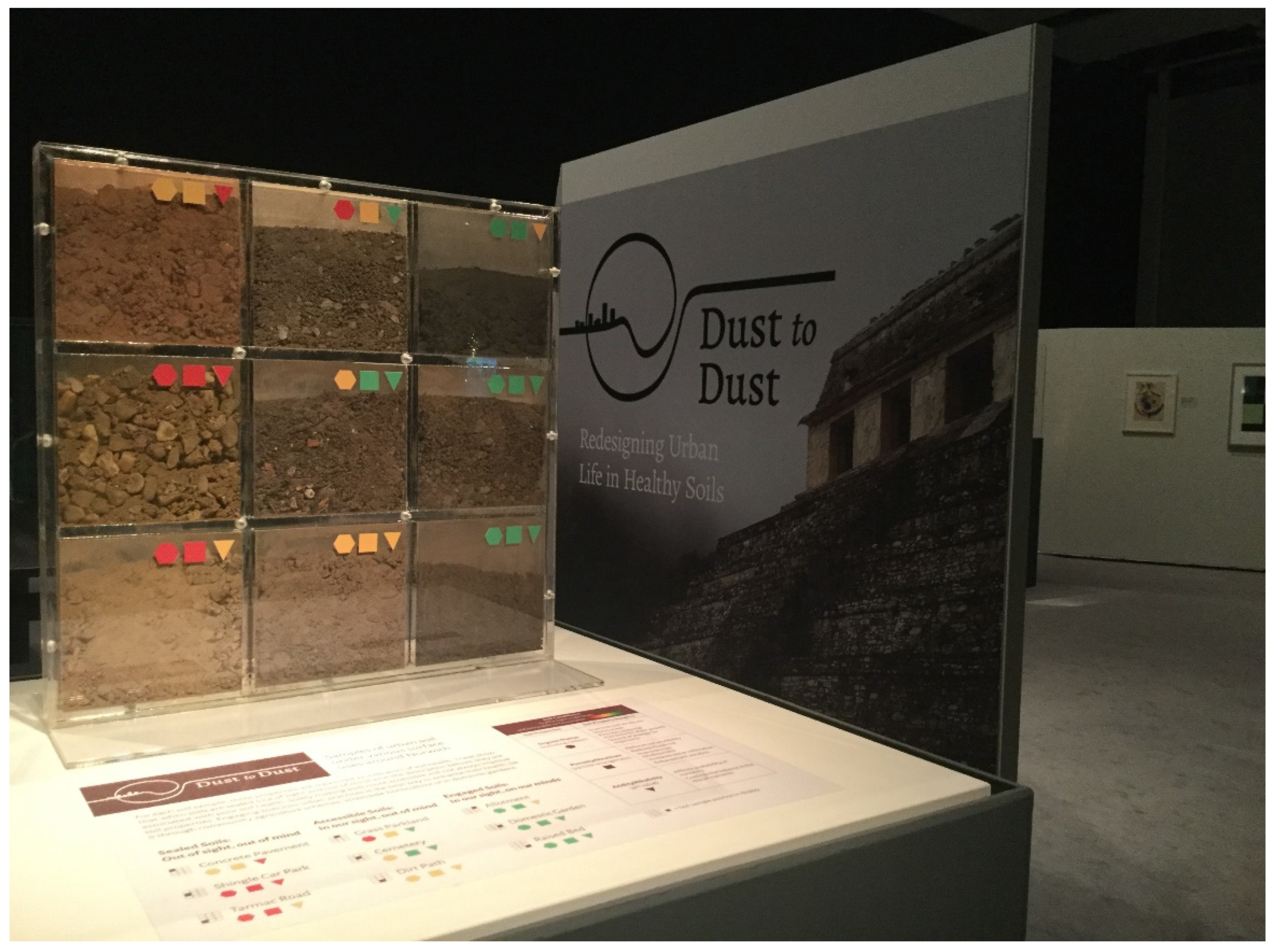
  105. Vis, B.N.; Evans, D.L.; Isendahl, C.; Graham, E. Dust to Dust: Redesigning urban life in healthy soil. Air Water Environ. Int. 2020, 66, 47–55. [Google Scholar]
  106. Bee, M.; Clément, G. Soil as Space of Indecision. OASE 2022, 110, 145–151. [Google Scholar]
  107. Kuzniecow Bacchin, T.; Recubenis Sanchis, I. Soil, Planning and Climatic Crisis in the Dutch Upper Delta. OASE 2022, 110, 167–175. [Google Scholar]
  108. Gwagwa, A.; Dipura, R.; Baranyk, I. From Suitcase to Mayor: A subversive politics of soil care. OASE 2022, 110, 199–201. [Google Scholar]
Figure 2. We exemplify how soil edge mapping could be applied, using a number of occurrences of urban soil in the Roma neighbourhood of Mérida, Yucatán. The numbers in the top aerial photograph indicate the following urban soil situations: (1) soils found in the margins of built space, presumably public space, which are highly accessible and especially proximal to residents of the adjacent street; (2) publicly accessible soils, part of a park and playground maintained by the municipality; (3) soil contained as part of the grounds of an educational institution, which would be at times accessible through membership of the educational community and may be maintained in part to serve specific activities; (4) soil contained on an as yet undeveloped private and fenced plot, inaccessible to the public; (5) soil supporting an area of vibrant vegetation, devoid of clear access ways, surrounded by development, it is unclear if this is private or public land; (6) soil contained in a privately run parking lot, to which the public have paid access, but not to engage with soils, which sole purpose may be to support grass vegetation to keep the area neat; (7) soil supporting select trees and vegetation as part of gardens may look deceptively green while concealing that the soil itself is virtually sealed unto the stems of that vegetation; and (8) soil wedged in between a major traffic artery (part of a disused railway), which is highly accessible to any member of the public when traversing, but remains underused. The lower parts show the street scenes of situations 1–4. The yellow edge indicates the inaccessibility of urban soils due to impermeable walling. The green edges indicate publicly accessible soils without physical restrictions. The orange edge indicates sealed soil with some permeability (here, tiles or sand). The blue edge indicates visible yet inaccessible soil as part of private land. The red edges indicate impermeably sealed soils by concrete and tarmac surfaces, only mitigated by cracks formed by ageing. (Background images credit: Google Earth © 2023).
Land 12 00891 g002
Figure 3. The soil display opening the Dust to Dust: Redesigning urban life in healthy soils exhibition at the Sainsbury Centre, Norwich, UK, which generates public awareness that productively used urban soils have the most beneficial properties. (Image credit: Daniel Evans).
Land 12 00891 g003
Disclaimer/Publisher’s Note: The statements, opinions and data contained in all publications are solely those of the individual author(s) and contributor(s) and not of MDPI and/or the editor(s). MDPI and/or the editor(s) disclaim responsibility for any injury to people or property resulting from any ideas, methods, instructions or products referred to in the content.

