Article

Ecosystem Quality Assessment and Ecological Restoration in Fragile Zone of Loess Plateau: A Case Study of Suide County, China

1
College of Landscape Architecture and Arts, Northwest A&F University, Xianyang 712100, China
2
Shaanxi Forestry Survey & Planning Institute, Xi’an 710127, China
3
Xi’an Urban Planning & Design Institute, Xi’an 710127, China
*
Author to whom correspondence should be addressed.
Land 2023, 12(6), 1131; https://doi.org/10.3390/land12061131
Submission received: 6 April 2023 / Revised: 21 May 2023 / Accepted: 24 May 2023 / Published: 26 May 2023

Abstract

:
The Loess Plateau is the world’s largest loess landform region, characterized by a fragile ecosystem and frequent natural disasters that render it highly susceptible to ecological damage, highlighting urgent ecological restoration. We constructed a “Pattern-Service-Stress Ecosystem Quality Assessment Model” based on the connotation of ecosystem quality and the ArcGIS platform, then applied it to Suide County, a representative area of the Loess Plateau, as the research object. Next, using the dispersal ecology theory and the MCR model, we constructed an ideal ecological network. According to the quality assessment and ecological network analysis, we selected areas with low ecosystem quality within the scope of an ecological corridor as key areas for restoration. Finally, we proposed restoration strategies using regional ecological techniques. This study yielded the following results: The spatial pattern of ecosystem quality in Suide County exhibited a “high in the south and low in the north” pattern, with a high-value area of 823.87 km2, and a low-value area of 509.31 km2, accounting for 44.45% and 27.48% of the total area, respectively. In Suide County’s ecological network, the spatial distribution of ecological sources and corridors is dense in the south and sparse in the north, with a significant amount of path overlap within ecological corridors. Located on the southern ecological corridor of Suide County, forty-five key areas for restoration were classified into seven types. Eight problems were identified in the key areas, and twenty-three targeted restoration measures were proposed. These measures can result in 6.44 km2 of forest land and 5.26 km2 of grassland, improving the ecosystem quality of the key areas and even the entirety of Suide County. This study guides Suide County’s ecological restoration work and provides a paradigm for ecosystem quality assessment and ecological restoration on the Loess Plateau, pointing out directions. It has a certain radiation-driven effect and an important reference significance for ecological restoration in ecologically fragile areas.

Graphical Abstract

1. Introduction

Ecosystems play a crucial role in the coexistence of human society and the natural environment, as well as in achieving sustainable development. In 2001, the Millennium Ecosystem Assessment was jointly launched by the United Nations Environment Programme and the International Intergovernmental Science Policy Platform to study the health of ecosystems at a global scale [1]. This project has had a profound impact on the study of global ecological and environmental issues, and sustainable development. However, due to increasing human activities, intensive land development, and the introduction of pollutants, the ecosystem in China is facing severe threats [2]. Such a remarkable transformation has resulted in devastating consequences for the environment and ecosystems [3]. Ecosystem degradation, reduced biodiversity, and weakened carbon sink capacity have become increasingly prominent issues. Therefore, urgent efforts are needed to restore ecosystems.
Located in the middle reaches of the Yellow River, the loess hilly and gully region not only plays an important role in performing local grain production, water conservation, soil conservation, and other ecological functions, but also provides water conservation, irrigation, and other spillover ecological services for the downstream regions. However, the region is recognized as a fragile ecological environment globally due to its gullies and ravines, complex and broken topography, severe water and soil erosion, and land degradation, making the ecosystem highly vulnerable to damage [4,5,6]. Although the local forest coverage has increased to some extent since the implementation of reforestation in 1999, no significant improvement in ecological restoration and ecological service functions has been witnessed so far [6]. Despite several previous studies and restoration efforts, the Loess Plateau still faces issues, including the accurate identification of ecological issues, unclear restoration focus areas, less holistic consideration, and insufficient specificity and personalization in ecological restoration plans. Therefore, it is crucial to identify the priority areas for ecological restoration from a holistic perspective and provide targeted measures for ecological restoration in the Loess Plateau. To ensure the practicality of ecological restoration plans [7], we deliberately chose the county level as the scale of observation. Suide County, located on the Loess Plateau, is a typical area of the Loess Plateau and has been previously studied [8,9]. Therefore, assessing ecosystem quality and ecological restoration in Suide County can provide a model and guidance for ecological restoration work in the Loess Plateau region.
According to scholarly research, the regional ecosystem quality can characterize the health of an ecosystem in a specific area. The definition of ecosystem quality varies both domestically and internationally. Scholars define regional ecosystem quality as “the inherent natural properties of regional ecosystems and ecological products, as well as their applicability and satisfaction for the survival and development of human society” [10,11]. Ecosystem quality is mainly affected by ecological attributes of an ecosystem’s authenticity, integrity, multifunctionality, and stability [10]. Ecosystem quality describes the characteristics of the ecosystem itself, characterizing the health of the ecosystem and the sustainability of existing ecological functions under the influence of natural and socio-economic conditions [12]. Therefore, ecosystem quality assessment needs to focus on the stability and integrity of the ecosystem structure itself, the ability of the ecosystem to provide various services to humans, and the degree of human impact on the ecosystem.
Foreign countries have been studying ecosystem quality since the early 1980s, with typical representatives, such as the U.S. Environmental Protection Agency, proposing environmental monitoring and assessment programs at different scales [13]. As the concept and practice of ecosystem quality continue to evolve, the study of ecosystem quality has been divided into two primary areas: the comprehensive study and evaluation of all types of ecosystems within a particular region, and the evaluation of a single type of ecosystem. These two approaches have slightly different research objectives and scopes of application. Studies that evaluate all types of ecosystems within a specific region, such as the evaluations of ecosystem quality in Anhui Province [14], the Sahel region in Africa [15], and Puer City [12], aim to assess the overall quality of ecosystems and the integrated level of ecological services in the region. This approach can provide holistic guidance and decision support for ecological conservation and restoration in the region, and help to achieve ecological sustainability. Holistic evaluation can provide comprehensive and systematic information, which is more adequate for decision support. Studies that evaluate specific ecosystems, such as forest ecosystems [16], freshwater ecosystems [17], watershed ecosystems [18], and urban ecosystems [19], aim to assess the health status of that ecosystem, the ability to supply ecological services, and the vulnerability of the ecosystem. This research approach can provide a detailed understanding of the ecosystem and provide guidance for its conservation and restoration. Single-ecosystem evaluations can delve into the problems and challenges of a particular ecosystem and provide more fine-grained guidance for the conservation and restoration of individual ecosystems. Taken together, the advantages of the two evaluation methods depend largely on the purpose of the specific study and the characteristics of the study area. Using a set of models to comprehensively evaluate the quality of all ecosystem types in Suide County can identify the characteristics of each type of ecosystem and the interconnections and interactions among them. This approach can better assess the overall ecological condition of Suide County and thus facilitate the ecological restoration work carried out in the area.
For the comprehensive evaluation of ecosystem quality, scholars have explored evaluation systems for ecosystem quality using methods such as ecological footprint and Remote Sensing Ecological Index (RSEI) [14,15]. The main aspect of ecosystem quality that the ecological footprint focuses on is the impact of human activities on the environment. By using this method, researchers can evaluate the sustainability of human activities and identify areas where improvements can be made to reduce environmental impacts. Therefore, ecological footprint is an effective tool for evaluating the degree of a coordinated development of ecological environment quality and the supply–demand relationship of ecological footprints. RSEI primarily evaluates ecosystem quality using remote sensing data. Remote sensing images can better reflect vegetation conditions and monitor changes in the ecological environment over a large scale and a long period of time. Through RSEI, studies aim to provide insights into the long-term monitoring of ecological environment changes in the region and inform strategies for protecting the ecological environment. However, these studies and their models are mostly limited to a single perspective, focusing only on one or a few aspects of the ecosystem to address specific single problems, and have not comprehensively evaluated ecosystem quality. In addition, previous evaluations of ecosystem quality have not been closely linked to ecological restoration and have not provided sufficient scientific basis for ecological restoration work. This deficiency has reduced the necessity and significance of ecosystem quality evaluation. However, by deeply understanding the connotations of ecosystem quality and combining the identification and diagnosis of ecological problems from the perspective of the life community, the ecosystem quality model constructed can comprehensively evaluate the development status of ecosystems in the study area, identify the weak links and potential risks of the ecological environment, and provide a scientific basis for targeted ecological restoration measures. Therefore, this model is particularly suitable for the Loess Plateau’s ecologically fragile areas that are in urgent need of ecological restoration, and it can promote the sustainable development of ecosystems. Ecological restoration is the process of assisting the recovery of an ecosystem that has been degraded, damaged, or destroyed [20]. This process assists the recovery of ecological processes in order to recover impaired natural and semi-cultural ecosystems that satisfy not only socioeconomic values, but also cultural, personal, and ecological ones [21,22]. To carry out ecological restoration effectively, certain basic principles need to be followed. These include valuing the natural restorative capacity and complexity of ecosystems, emphasizing the integrity and sustainability of ecosystems, and promoting human–nature participation and cooperation. These principles provide guidance and methodology for ecological restoration, aiming to restore and rebuild damaged ecosystems and promote their sustainable development. The practice of ecological restoration requires a holistic perspective of the entire ecosystem, and appropriate engineering techniques should be used based on local conditions to achieve long-term effectiveness and sustainability. At the national level, the concept of “mountains-rivers-forests-farmlands-lakes-grasslands life community” is a concept for ecological restoration. This concept is rooted in ecological ethics, environmental protection, and sustainable development theories, and aims to illustrate the interdependence and interaction among ecosystem elements, with the characteristics of wholeness, systematicness, and balance [23,24]. It reflects the synergy and organic connections among various ecosystems [25], and promotes the development of ecological restoration towards integration. To better evaluate and restore the ecosystem, the perspective of the life community should be adopted, and the construction of an ecological network should be considered to identify the importance of the ecological restoration area to the whole [26,27]. Additionally, engineering methods and techniques, such as the Miyawaki method [28], the site-specific selection of tree species [29], and the installation of shrub buffer strips [30], are applicable to the Loess Plateau and can make concrete contributions to ecological restoration.
In light of this context, this study took Suide County, a typical area of the Loess Plateau, as the study area. By exploring the connotations of ecosystem quality and identifying and diagnosing ecological problems from the perspective of a life community, we constructed an ecosystem quality assessment model that both comprehensively reflects the ecological condition of the Loess Plateau and provides a theoretical basis and ideas for ecological restoration. It was then used to evaluate the ecosystem quality of Suide County. Next, an ecological network was generated by identifying ecological sources and constructing a resistance surface under a holistic perspective. Thereafter, the ecological network was overlaid with the ecosystem quality assessment to identify key areas with relatively low ecological restoration costs and high restoration benefits. Finally, the key areas for restoration were classified based on changes in land use types and ecological problems, and specific ecological restoration measures were proposed.

2. Materials

2.1. Study Area

Suide County (110°04′–110°41′ E, 37°16′–37°45′ N) is located in the southeast of Yulin City, Shaanxi Province, with a total land area of 1853 square kilometers and 15 towns in the county (Figure 1). Suide County is between 608 m and 1287 m above sea level, with an average altitude of 920 m. The terrain is highest in the northeast and lowest in the southeast, with a general trend of gradual decrease from the northwest to the southeast. Yellow River bends southward in the southeast boundary of the county. Wuding River flows from the county’s north to the southeast. Dali River flows from the northwest to the southeast of the county into the Wuding River. Suide County belongs to the first attached area of loess hills and gullies, which is a typical loess hilly and gully region, mainly in the loess hills. In addition, due to the cutting and alluvial accumulation of the Yellow River and the Wuding River, many valley areas have been formed. The county is a national key county for soil erosion control, a demonstration county for ecological environment construction, and a national poverty-stricken county. For a long time, serious soil erosion, a poor production environment, and a weak economic base have restricted the sustainable development of its agriculture and rural economy [31].
Based on the distribution of land use types of Suide County in 2020 (Figure 2, Table 1 and Table 2), it was found that the farmland area is 927.95 square kilometers, accounting for 50.07% of the total land use, which is the main type of land use in Suide County, with a high degree of fragmentation. Forest and grassland account for 15.15% and 31.99% of the total land use, respectively, and their spatial distribution is relatively scattered. In addition, construction land is concentrated along the river, while the majority of unused land is located in the southeast. The unused land, containing bare land and bare rocky gravel land, is difficult to repair due to its high slope and harsh geography. Forest ecosystems have better biomass, carbon sequestration capacity, and restoration ability than grassland ecosystems [32,33]. However, the percentage of forest land in Suide County’s land use is far less than that of grassland, indicating that a large percentage of the county’s ecosystems have a simple biological community structure, fewer ecological niches, and low ecosystem quality, which requires ecosystem quality evaluation and restoration. Therefore, the area is encouraged to convert grassland and farmland with natural geographical conditions into forest land to enrich the biological community and improve the ecosystem quality in Suide County.

2.2. Data Resources

This study chooses eight kinds of data, which are DEM (Digital Elevation Model), Landsat8, land use type, soil erosion intensity, evaporation, precipitation, NPP (Net Primary Productivity), and the third national land survey data. Their detailed information is in Table 2.

3. Methods

3.1. Construction of Pattern–Service–Stress Ecosystem Quality Assessment Model

For the evaluation of ecosystem quality, we have selected the following primary indicators: ecosystem pattern, ecosystem services, and ecological stress. Corresponding secondary indicators were also selected to characterize the primary indicators and amplify regional characteristics of the Loess Plateau to complete the construction of the pattern–service–stress ecosystem quality model (Table 3). As previously mentioned, ecosystem quality is affected by the ecological attributes of ecosystem authenticity, integrity, multifunctionality, and stability. Ecosystem authenticity refers to the degree to which the original features of the ecosystem are preserved under human activity. Ecosystem integrity refers to the completeness of the spatial pattern, food web, and ecological elements of real ecosystems under human activity. An ecosystem pattern is used to represent the authenticity and integrity of an ecosystem [3,12]. Ecological multifunctionality is the ability of an ecosystem to provide various services, which is characterized by using ecosystem services [3,18,34]. Ecological stability is a comprehensive characteristic of an ecosystem’s ability to withstand natural environmental changes and human interference, which is characterized using ecological stress [35,36]. On 26 August 2020, the Chinese Ministry of Natural Resources, the Ministry of Finance, and the Ministry of Ecology and Environment jointly issued the “Guidelines for the Protection and Restoration of Mountain-Water-Forest-Farmland-Lake-Grassland Ecosystems (Trial)” [37]. This guideline serves as an important guide for scientifically carrying out the integrated protection and restoration of mountain–water–forest–field–lake–grass ecosystems and offers a guiding position. The guideline considers ecosystem pattern, habitat quality, ecosystem services, and ecological stress as the four dimensions of identifying and diagnosing ecological problems that align with the connotation of ecosystem quality. The constructed model comprehensively covers almost all aspects of identifying and diagnosing ecological problems, reflecting the status and trends of the ecosystem, therefore better guiding the protection and management of the ecosystem, and laying the foundation for subsequent ecological restoration.

3.1.1. Ecosystem Pattern

The ecological pattern approach considers the region as a whole, emphasizing the integrity of ecological processes, and takes into account the integrity and coordination of various ecological elements in the region in the research process [38]. By constructing an ecological security pattern, patches, corridors, and key areas of regional ecosystems can be identified. The spatial distribution of these critical elements can demonstrate the spatial distribution and interaction mode of each component of the ecosystem, as well as the overall structure of the ecosystem, thereby highlighting the ecosystem’s authenticity and integrity.
The ecosystem pattern in the Loess Plateau region is complex, diverse, and heterogeneous. The region is primarily characterized by loess landforms and wind erosion landforms, which have resulted in gullies and ravines, a complex topography, and large undulations. Additionally, its diverse land use patterns have led to the intertwining and interweaving of different ecosystem types in different geographical locations, resulting in different landscape types, such as core, bridge, and branch, and forming complex ecological patterns. The existence of these patterns impacts the complexity of the ecosystem in the Loess Plateau region and plays a significant role in the stability and adaptability of the ecosystem.
What we need is to obtain visual data on the ecosystem pattern at the county level. Currently, the MSPA (Morphological Spatial Pattern Analysis) and Landscape Pattern Index are widely used methods in academia. MSPA, based on mathematical morphology concepts, categorizes arbitrary binary patterns into seven types: core, islet, loop, bridge, perforation, edge, and branch [39]. Landscape pattern indices are measures for quantifying the composition and configuration of ecosystems across a region or study area. They have been used to characterize different study areas or regions or to measure a region’s landscape change through time [40].
This study utilized the MSPA method and verified it with the landscape pattern index, to assign values to individual landscape elements, ultimately achieving the quantification of an ecosystem pattern. The specific reasons are as follows: (1) The MSPA method is well-suited for analyzing ecosystem patterns at small scales in counties, offering accurate and reproducible mapping and analysis of patterns at multiple observation scales. This enables ecologists to perform better analytical treatments [41]. However, applying landscape pattern indices to a highly fragmented landscape of fine-scale habitat patterns for the Loess Plateau does not yield valid information [40]. (2) The MSPA method is better suited for producing visualized data, as it can directly identify hubs and links from a single land-cover map, rather than a GIS overlay of several maps, by creating structure from the spatial relationships among land-cover features [42], and it can accurately derive landscape ecotypes and structural elements at the meta-level, leading directly to visualized pattern maps. In contrast, visualizing the landscape pattern index requires the use of the moving window analysis method, which can distort edges and reduce the accuracy of the ecosystem pattern. This may affect the specific edge selection of priority restoration sites in the next step.
For the analysis of ecosystem patterns, we adopt the MSPA method with reference to previous studies [27], with forests and grasslands considered as the foreground and other land use types as the background. Through multiple tests and the use of data from previous studies [42], we determined that a physical distance of 60 m at the edge yields the most reasonable results for Suide County. Next, we assigned corresponding values to each category based on their ecological characteristics to quantify the quality of their spatial patterns. The ecological meaning of landscape types and their specific quantification are presented in Table 4.

3.1.2. Ecosystem Services

Ecosystem services are natural processes that benefit humans [43], and they provide an important portion of the total contribution to human welfare on this planet [44]. Ecosystem service valuation plays a significant role in environmental policy making as it characterizes the multifunctionality of ecosystems, helps people to better understand the various services and benefits that ecosystems provide for human well-being, and supports ecological conservation and sustainable development.
The region’s unique geographical environment and natural characteristics make ecosystem services particularly important in the Loess Plateau. The food and raw material supply services provided by the region are valuable to local economic development. The maintenance of biodiversity services is essential to ecological restoration and sustainable development. Carbon sink services, which measure the carbon sequestration capacity of the Loess Plateau, are crucial for climate change mitigation and the improvement of local natural conditions. These ecosystem services are not only vital for the livelihoods of local people and ecosystem functions, but also for global ecosystem health.
Previous studies have classified ecosystem services into a provisioning service, a regulating service, a cultural service, and a supporting service [45,46]. Since a cultural service has no direct impact on the quality of the ecosystem itself, we selected the other three indicators for ecosystem service measurement.
  • Provisioning service: with reference to previous studies’ data and the current situation of Suide County, we used the unit area value equivalent factor to evaluate the supply service capacity of regions with different land use types [47,48,49,50], as shown in Table 5.
  • Regulating service: we selected the carbon sink capacity to characterize the regulating services of the ecosystem, measured by NPP [51].
  • Supporting service: Biodiversity was chosen to characterize the supporting services of the ecosystem, and it was measured by processing NDVI (Normalized Difference Vegetation Index) into FVC (Fractional Vegetation Cover) through linear stretching [52]. NDVI data were obtained by processing Landsat 8 data using ENVI software [28].

3.1.3. Ecological Stress

The term “ecological stress” simply refers to the negative impacts on the ecosystem or its biotic components due to various causes, most of which are anthropogenic [53]. The evaluation of ecological stress can reveal the stability and vulnerability of an ecosystem, as well as its ability to respond to different disturbances and pressures. Furthermore, assessing ecological stress can assist in developing strategies and measures to protect and restore ecosystems, thus preserving their health and functionality.
Due to population growth, resource depletion, and climate change, the Loess Plateau region is highly ecologically vulnerable, under significant pressure from human activities, and presents significant challenges for ecosystem restoration and reconstruction. Population stress accelerates land degradation and a loss of biodiversity. Industrial stress exacerbates habitat pollution. Transport stress hinders migration and population connectivity. These social stressors pose significant difficulties in the restoration and rehabilitation of the Loess Plateau ecosystem. Additionally, drought causes water scarcity, vegetation degradation, and reduced crop yields. Flash floods cause serious hydrological disasters. Soil erosion accelerates land impoverishment and soil erosion. These natural stresses further disrupt the ecological balance and impede sustainable land use. The interplay of these stressors has put the Loess Plateau ecosystem under tremendous pressure, posing important challenges to the protection and restoration of the ecosystem’s functions and sustainable development. Therefore, identifying the spatial differentiation of these stresses on the ecosystem is crucial to maintain the stability and sustainability of the ecosystem.
We categorize ecological stress into natural stress and social stress. Natural stress primarily reflects the impacts of natural disasters on ecosystems, while social stress represents the stress caused by human activities on the ecological environment [54,55]. Considering the ecological conditions in Suide County, we selected three indicators to characterize social stress: population stress [56,57], industrial stress [54], and transportation stress [58].
The process of visualizing population pressure and industrial pressure is as follows. Buildings, industrial sites, and mining sites in the third national land survey data are converted into points by the “feature to point” function in ArcGIS. Then, the area of the region is then used as a weight and a “kernel density” is performed on these points. The results obtained represent the impact of human distribution and industrial mining on the surrounding environment. For transportation stress, we used “line density”, with different weights assigned to national and other roads, to characterize their impact on the ecosystem.
For natural stress, we selected three indicators: drought stress [59,60], flash flood stress [61], and soil erosion stress [54,62].
Previous research has indicated that using the K index to measure drought in the Loess Plateau is feasible and relatively accurate [63]. The calculation formula for the K value model is as follows:
K = P / E ,
in the formula, K is the value of the drought day monitoring index. P′ and E′ are the relative change rates of precipitation and reference evapotranspiration, respectively.
The P′ is given by:
P   =   P / P ¯ ,
where P is the accumulated precipitation for a certain month and P is the average precipitation for the corresponding month over the past 30 years (i.e., normal climate).
The E′ is given by:
E = E / E ¯ ,
where E is the cumulative reference evapotranspiration for a certain month (the same as P), and E is the average reference evapotranspiration for the corresponding month over the most recent 30 years (i.e., under normal climate conditions). The FAO Penman–Monteith method is used to calculate E in this article. By using the aforementioned formula, we calculated the K value for each month from 2011 to 2020. We corrected the part where K is greater than 1 to 1. After that, drought data was generated by assigning weights to K values, based on the Ka values representing the severity of drought in Shaanxi Province, by referring to the “Meteorological Drought Grades” (Figure 3). As for flash floods, we comprehensively overlaid NDVI, the K value, topographic relief, elevation, and river network density in Suide County to obtain the spatial distribution of flash flood impacts [64,65]. The calculation method for NDVI has been described in a previous text. Similarly, the K value data was generated using the method mentioned above, with the difference that the corrected K values less than 1 were set to 1. The topographic relief was calculated based on DEM data [64], while the river network density was obtained by calculating line density through rivers. Soil erosion stresses were utilized by soil erosion intensity data from the National Tibetan Plateau Scientific Data Center.

3.2. The Weight Calculated by AHP–EWM Model

This study calculated the weights of indicators in the ecosystem quality assessment by combining the AHP (Analytic Hierarchy Process) and EWM (Entropy Weight Method).
AHP is a subjective method for calculating weights for multi-level and multi-objective decision problems. However, AHP requires the quantification of decision-makers’ professional knowledge and judgment, which can be influenced by subjective factors such as values, experience, and biases [66]. In addition, EWM can fully utilize the information in the original data and objectively display the weight of each indicator. However, EWM only starts from the measured data itself, ignoring the relationship between the various index factors of the measured data, and is greatly affected by the digital discrimination of the data [67,68].
The combined use of AHP and EWM leverages their respective strengths while reducing the subjective influence of AHP and avoiding potential deviations from actual production by EWM. This provides a scientific method for determining the weights of ecosystem quality assessment indicators. The calculation method of the AHP–EWM model is presented below.
We invited 10 experts in related fields to fill in a questionnaire and used AHP to calculate subjective weights. The objective weights were obtained by data calculation using EWM. Next, we introduced the concept of distance function and used the linear combination to obtain the combined weight wi in ecosystem quality assessment [69,70].
The expression for the combination weights is as follows:
w i = α w i + β w i
where a and B are the distribution coefficients of the weights, α + β = 1 .
The expression of the distance function between subjective weights and objective weights is:
d ( w i , w i ) = [ 1 2 i = 1 n ( w i w i ) 2 ] 1 2
The difference between a and B is the difference between the distribution coefficients.
D = α β
The system of equations is constructed from the above as follows.
d w i , w i 2 = ( α β ) 2 α + β = 1
By solving Equation (7), we can obtain the allocation coefficients α and β for each weight. The combined weight is obtained by substituting the allocation coefficients into Equation (4). The results are shown in Table 6.

3.3. The Construction of the Ecological Network and the Selection of Key Areas for Restoration

An ecological network refers to a comprehensive network with biodiversity protection and ecosystem service functions based on the ecosystem pattern, composed of ecological sources, ecological corridors, and other ecological spatial units, reflecting the concept of dispersal ecology. Ecological corridors are belt-like areas in an ecological network that are important for the connectivity of material, energy, and information flows [2,71]. Ecospatial networks are based on an holistic view of the structure and the spatial distribution of ecosystems, in line with the principle of wholeness from the perspective of the community of life. The ecological network allows us to identify new potential conservation areas to maximize the representation of biodiversity and improve the conservation of ecosystems in the medium and long term. This information is of great value because it can provide new and more accurate evidence that can guide current conservation decision-making processes [72].
Therefore, establishing and restoring the ecological space network is of great significance for biodiversity recovery, the maintenance of ecosystem quality, and the selection and proposal of priority restoration areas [72]. It can not only facilitate the most efficient maintenance of regional ecological security but can also provide a theoretical basis for the government to enact reasonable ecological restoration measures in different areas [3,73,74], while minimizing cost input.
In this study, we initially extracted the top 30 ecological sources using the landscape type core and ranked the top 15 ecological sources as first-class ecological sources according to the PC (probability of connectivity) and the dPC (delta of PC) in the landscape index based on MSPA analysis [75]. The remaining sources were designated as second-class ecological sources. Subsequently, we constructed a resistance surface using the MCR (Minimum Cumulative Resistance) model by weighting and superimposing terrain undulation and land use type assignments [76].
In order to amplify the degree of ecological disturbance of different land use types, we refer to the previous literature [77,78], and assign the ecological resistance coefficients of different land use types. In detail, the coefficients of forest land, grassland, waters, farmland, unused land, and construction land were 1, 5, 10, 40, 100, and 300, respectively, and were then superposed with terrain undulation to calculate the resistance surface.
Finally, ArcGIS was used to calculate and construct ecological corridors to obtain the ecological network. The calculation model is as follows:
MCR = f m i n j = n i = m ( D i j × R i ) ,
where MCR refers to the minimum cumulative resistance value, D i j refers to the spatial distance from the source to the landscape unit, and R i refers to the resistance value of the landscape unit.
In order to improve the selection of priority restoration areas, a grading system was assigned to ecological corridors. The corridors between primary ecological sources were considered as first-class ecological corridors, while the corridors connecting first-class ecological sources to second-class ecological sources were labeled as second-class ecological corridors. Line density analysis and normalization were performed to identify important areas for the construction of the ecological space network. Subsequently, the negative impact on ecosystem quality was superimposed with corridor density to obtain a map of key restoration areas. This map clearly indicates areas that are crucial to the overall ecosystem, as well as areas with relatively poor ecosystem quality, allowing for a scientific and clear selection of priority areas and their specific boundaries from a holistic perspective of the community of life. Additionally, the ecological restoration of key areas not only incurs relatively lower costs compared with the restoration of entire areas but also yields enormous benefits that can be instrumental in promoting the overall improvement of the ecosystem quality in Suide County.

4. Results

4.1. Ecosystem Quality Assessment Results

4.1.1. Ecosystem Pattern

As shown in Figure 4, from the perspective of ecosystem pattern factors, the core area represents large natural patches with high-quality ecosystems. It is mainly distributed in the southern part of Suide County, including a considerable amount of forest and grassland. The core area in the northern region is limited and fragmented. Although bridges and branches are distributed throughout the region, the relatively scattered distribution of the core area patches leads to poor connectivity between these patches, which is not conducive to the diffusion and exchange of biological material between patches in the core area. Farmland, urban areas, and unused land are all background areas and do not have ecological benefits. Other landscape types have small areas scattered throughout Suide County and have a relatively minor impact on the holistic ecosystem pattern of Suide County.
From the assessment results of the ecosystem pattern, the high and higher middle areas of Suide County have an area of 442.60 km2, accounting for 23.88%; the middle area has an area of 284.29 km2, accounting for 15.34%; and the lower middle and low areas have an area of 1126.43 km2, accounting for 60.78%. The holistic ecosystem pattern index of Suide County is relatively low, possibly because the disorderly distribution of farmland has led to the fragmentation of the holistic patches in Suide County, and no comprehensive ecological restoration has been carried out. The assessment of the ecosystem pattern in the southern region is generally higher than that in the northern region. The areas with a high ecosystem pattern assessment are mainly concentrated in large areas of grassland and forest, while the areas with a low assessment are mainly farmland, construction land, and unused land. The edges of the forests and grasslands are influenced by the low external pattern areas and tend to have a medium ecosystem pattern assessment.

4.1.2. Ecosystem Services

As depicted in Figure 5, from the perspective of ecosystem service factors, cultivated land exhibits the best service supply, followed by forest and grassland, while construction land and unused land have the poorest service supply. With regards to supporting services, Xuejiamao Town, Cuijiawan Town, and Dingxianyan Town in the southern part of Suide County, and Tianzhuang Town in the southeast, exhibit the strongest supporting service capacity and the best biodiversity, while the northwest, county town, and southeast regions exhibit relatively weaker supporting service capacity. In terms of regulating services, Suide County has good regulating services, with the central and western regions being slightly better than other areas, while the urban area continues to perform poorly. Overall, the performance of each element in Suide County is relatively good, but the construction land factor in the county town performs poorly.
Based on the assessment results of the ecosystem services, the high and higher middle regions in Suide County encompass an area of 954.78 km2, accounting for 51.52%; the middle region encompasses an area of 400.66 km2, accounting for 21.62%; and the lower middle and low regions encompass an area of 497.89 km2, accounting for 26.86%. The holistic level of the ecosystem services in Suide County is relatively high, which may be attributed to the ecological restoration measures implemented in the early stage. The region with the highest value is located in the cultivated land along the river and the high-quality forest and grassland, which possess superior natural conditions, high vegetation coverage, and the capacity to provide various services. However, there are also two areas with low levels of ecosystem services, namely, the construction land in the central region and the unused land along the river in the southeast corner. Due to natural reasons or human activities, the vegetation coverage in these two areas is low, making it difficult to provide services.

4.1.3. Ecological Stress

As depicted in Figure 6, the ecological stress levels in Suide County vary significantly based on ecological service factors, with the northwest experiencing higher stress levels than the southeast. In particular, the urban areas and river-side regions of the county face very high stress levels due to population pressure. Industrial stress is predominantly concentrated in the industrial areas along the river in Sishilipu Town and Xindian Township and their surrounding regions, while sporadic stress is observed in other areas. Traffic stress has a huge impact on the ecosystem of the northern section of the Wuding River, and, due to the fact that some national highways and other roads run from east to west, traffic stress affects the central part of Suide County, especially the road intersections. Generally, areas with lower terrain, such as the plains and areas along the river, have higher ecological stress due to frequent human activities. The degree of drought-induced stress decreases from west to east, while the areas of northeastern and western mountainous areas of Suide County, and the southern side of Cuijiawan Town, experience the highest stress levels caused by soil erosion. Flash flood stress is most severe in the areas along the Wuding River and the Yellow River basin in the southeast corner, while the tributaries of the Wuding River experience secondary stress. Generally speaking, there is no obvious rule for natural stress, and it is affected by different natural conditions, resulting in stress.
The ecological stress assessment results reveal significant differences in the holistic ecological stress levels in Suide County, with an area of 196.23 square kilometers in the high and higher middle areas, accounting for 10.59%; 584.94 square kilometers in the middle areas, accounting for 31.56%; and 1072.16 square kilometers in the lower middle and low areas, accounting for 57.85%. The northern region of the county experiences higher stress levels than the southern region due to soil erosion, and the eastern and western regions are more stressed than the central region. Ecological stress is most severe in the urban areas and industrial land along the Wuding River in Mingzhou Town, Shilipu Town, the Xindian Township, and the Zhangjiabian Township, while the areas along the river and transportation routes are also greatly affected by ecological stress. Forests, grasslands, and farmland situated far from urban areas face lower ecological stress.

4.1.4. Ecosystem Quality

After statistical analysis, the ecosystem quality in Suide County is mainly categorized as middle level (Figure 7 and Table 7). The spatial distribution pattern of ecosystem quality is characterized by a “high in the south and low in the north” pattern. The areas with good ecosystem quality are fragmented and not strongly connected as a whole.
According to Figure 7, the low-level ecosystem quality area is 16.09 km2, which accounts for 0.87% of the total area of Suide County. The main land use types in this area are construction land and a small amount of farmland. These areas are extremely vulnerable to human disturbances and are difficult to restore in the short term. They are concentrated in the urban area of Mingzhou Town and upstream mining areas, mainly affected by high landscape fragmentation, low ecosystem productivity index, high human interference, and high susceptibility to geological hazards. The lower middle-level ecosystem quality area is 493.22 km2, accounting for 26.61% of the total area of Suide County. The main land use types are unused land and some farmland. These areas are more easily disturbed by human activities and can cause instability in the ecosystem. Part of this area is distributed in the farmland area in the north of Suide County, mainly affected by high landscape fragmentation, high human interference, and a high susceptibility to geological hazards, resulting in a poor ecosystem quality. The other part is located in the unused land in the east of Zaolinping Town, with poor geographic conditions, less biomass, and biological diversity, resulting in poor ecosystem quality. The area of middle-level ecosystem quality area is 520.15 km2, accounting for 28.07% of the total area of Suide County. The main land use type is some farmland. These areas are mainly distributed in some farmland in the north and most of the farmland in the south of Suide County, which are affected by high human interference. The ecosystem pattern index in these areas is poor, the ecosystem service is good, and the ecological stress is generally formed by a comprehensive superposition to obtain the middle-level. The area of higher middle-level ecosystem quality area is 482.77 km2, accounting for 26.05% of the total area of Suide County. The main land use types are forests and grasslands. These areas are mainly distributed on the edge of high-quality areas, adjacent to low-quality ecosystem areas. Although the ecosystem quality is good, it is more susceptible to interference and influence from low-quality areas and has higher ecological stress. The area of high-level ecosystem quality area is 341.10 km2, accounting for 18.40% of the total area of Suide County. The main land use types are forests and grasslands. These areas are mainly distributed in the southern forest and grassland area, with a high ecosystem pattern index, strong ecosystem service capacity, and less ecological stress. This area represents the high-quality ecosystem area of Suide County.

4.2. Ecological Network Construction Results

As depicted in Figure 8, the total area of ecological sources in Suide County is 159.49 km2. The first-class ecological sources are generally concentrated in the central and southern parts, while the second-class ecological sources are more dispersed. The degree of agglomeration and the scale of ecological sources in the south are superior to those in other areas of the study area, whereas ecological sources in the north are fragmented and scattered. This study further revealed that the ecosystem quality of ecological source sites was generally preferred and could provide diverse ecological services to the ecosystem of Suide County. Using the MCR model, a total of 105 first-class ecological corridors with a total length of 110.34 km, and 225 second-class ecological corridors, were generated. Most of these corridors are situated in the central and southern parts of Suide, and the corridors are generally long and dense with a significant number of overlapping paths in potential ecological corridors with high redundancy. This indicates that the ecological connectivity in the southern part of Suide County plays a crucial role in the holistic ecosystem quality of Suide County. On the contrary, the ecological corridors in the northern area are mainly secondary corridors, are sparsely distributed, and have poor ecological connectivity. Considering the ecological conditions of Suide County and related studies [2,79], a corridor width of 100–300 m was determined. The corridor width can provide better migration space for species and reduce the impact of human activities. The establishment of the corridor width facilitates the identification of key areas for restoration in the subsequent step.

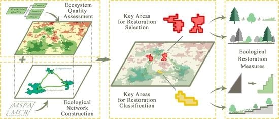
4.3. Identification and Measures of Key Areas for Restoration

4.3.1. Pattern and Classification of Key Areas for Restoration

We have identified key areas for restoration by conducting an overlay analysis of ecosystem quality and ecological networks in areas with severe ecological problems and a high potential for restoration. Suide County’s entire area was ranked by priority, and targeted ecological restoration was carried out accordingly. As illustrated in Figure 9, the priority restoration areas are primarily situated in the southern part of Suide County, with the key areas for restoration mostly consisting of farmland and grassland. Among these, the most urgent areas are mainly distributed along rivers. Most urgent, More urgent, and Urgent areas were selected to analyze their ecology in more detail.
We selected the top 50 key areas for restoration in order of size from largest to smallest, excluding basic farmland, resulting in 45 remaining areas (Figure 10). Basic farmland refers to farmland that cannot be occupied, as determined by China’s total land use plan based on the demand for agricultural products, population, and socio-economic development over a certain period. Compared with farmland, permanent basic farmland is of greater significance, with stricter protection and a more stable spatial pattern, and plays a vital role in stabilizing food production [80]. Based on the above basic idea, the researchers classified these areas into seven types, taking into account their land use types, local geographical and habitat conditions, and ecological problems. The classification is presented in Table 8.
Among the 45 restoration areas, the largest area after restoration will be converted into forestland. Specifically, the farmland into forest areas are scattered in the southern part of Suide County, while the grassland into forest areas are distributed along the rivers. The areas for forest degradation management are concentrated in the central and western regions. The areas for farmland into grassland and grassland degradation management are more dispersed. The areas for unused land transformation are located in the southeastern part. The watershed ecological corridor construction areas are situated in the downstream of the Wuding River and the southeastern corner of the Yellow River Basin. The restoration areas exhibit an overall pattern characterized by “a line with multiple points”. The “line” refers to the linear ecological restoration areas along the river basins, while the “multiple points” are distributed in the southeastern part of Suide County.

4.3.2. Categorized Restoration Plan of Key Areas for Restoration

Through the classification study of the top 45 key areas for restoration, the most typical areas were selected and comprehensively analyzed in terms of ecosystem patterns, ecosystem services, and ecological stresses. It was found that a series of serious ecological problems, such as watershed ecological degradation, soil erosion, and vegetation degradation, existed in the priority restoration areas to different degrees. Although the restoration priorities and restoration measures for compound formation were similar, they varied due to their different habitat conditions, geographical distribution, and land use types. Therefore, it is necessary to develop a detailed ecological restoration plan based on classification.
To address the various types of priority restoration sites, corresponding restoration plans were proposed based on problem identification. For example, the restoration strategy for the area of farmland into grassland is focused on level-terrace site preparation; the restoration strategy for the area of grassland degradation management is focused on grassland management; the restoration strategy for the area of grassland into forest land is focused on site-specific tree species selection; the restoration strategy for the area of farmland into forest land is focused on artificial afforestation and natural restoration; the restoration strategy for the area of forest degradation management is focused on the Miyawaki method; and the restoration strategy for the area of other land transformation is focused on the installation of a shrub buffer strip, and the construction of watershed ecological corridor construction. Moreover, the restoration strategies for industrial and mining land restoration, pollution control, and ecological slope protection were identified for the area with many problems. A detailed summary of the problems and restoration measures is provided in Table 9.

4.3.3. Blueprint for Ecosystem Quality of Suide County in 10 Years

In order to vividly demonstrate the results that can be achieved by the ecological restoration given above, a 10-year target and blueprint for ecological restoration in Suide County and an area comparison of ecosystem quality have been developed (Figure 11 and Table 10). This will serve as a guide and benchmark for the specific conditions of ecological restoration.
After statistical analysis, this study predicts that the quality of ecosystems in Suide County after restoration will be mainly at a moderate to a high level. Although the holistic spatial distribution of ecosystem quality still shows a pattern of “high in the south and low in the north”, the quality of ecosystems in both the north and south areas will be significantly improved compared with the period before restoration. As shown in the figure, the areas of low and lower-middle level ecosystem quality is expected to be 7.71 km2 and 342.63 km2, respectively, accounting for a total of 18.9% of the total area of Suide County. However, this holistic area is significantly reduced compared with the pre-restoration period, while the ecosystem quality of farmland in the northern and central areas will mostly improve to the middle level. The holistic area of the middle-level ecosystem quality will be 509.09 km2, accounting for 27.47% of the total area, and the overall area will remain basically unchanged, while the ecosystem quality in the southeast area will improve due to the construction and improvement of the ecological spatial network. The area of ecosystem quality above the middle level is 426.16 km2, accounting for 22.99% of the total area, with a significant increase in the overall area.
This study also predicts that various environmental problems such as soil erosion, flash flood invasion, and drought sanding in priority restoration areas will be alleviated through the restoration efforts. Natural ecosystems will be restored and reconstructed, land use types and layouts will be significantly optimized, and forest and grass vegetation cover will be significantly increased. Barren land will change from disorderly development to orderly development, and soil erosion on sloping land will be effectively controlled. Furthermore, the water environment quality in watersheds will be continuously improved, and the ecological environment of Suide County, which is composed of Suide County’s mountains, rivers, forests, farmlands, lakes, and grasslands, will be greatly improved. This is attributed to the improvement in water connotation and water supply capacity, the increase in biodiversity, and the great improvement in soil and water conservation capacity.

5. Discussions and Conclusions

5.1. Discussions

5.1.1. Connection: How to Integrate Ecological Restoration with Ecosystem Quality Assessment

In the practice of ecological restoration on the Loess Plateau, there are still several issues that need to be addressed. Firstly, there is still uncertainty in identifying and quantitatively analyzing ecological problems, which can lead to key restoration areas being neglected or not effectively restored. Furthermore, existing evaluation standards and methods for ecological problems require further refinement and improvement. Secondly, there is a lack of comprehensive planning and management, as well as zoning and classification guidance, which leads to an unclear selection and determination of priority restoration areas. This limitation prevents the full utilization of limited resources and funding to achieve maximum ecological restoration benefits and is far from the strategic goal of ecologically sustainable development [98]. Thirdly, the lack of specificity and personalization in ecological restoration plans makes it difficult to conduct targeted restoration according to the actual situations in different regions. Moreover, the lack of targeted scientific and technological support is one of the significant factors that affect the implementation of ecological restoration plans. What is urgently needed is a more effective policy system and increased research into more suitable environmental restoration intervention techniques in China, given the inherent risks of the Chinese project objectives [99].
To address these issues, a pattern–service–stress ecosystem quality evaluation model has been constructed in this study from the perspective of the community of life. This model can comprehensively reflect the status of the ecosystem and its causes, allowing for a more effective identification and diagnosis of ecological problems. Additionally, the combination of ecosystem quality evaluation and ecological network analysis can effectively select priority restoration areas, optimizing the use of funding and resources. Finally, based on quality evaluation, appropriately scientific and technological methods and means can be employed for ecological restoration according to local conditions, making ecological restoration plans more specific and scientific.
Therefore, ecosystem quality should be regarded as a prerequisite for ecological restoration and used as a scientific guide for restoration efforts. This approach will effectively address the issues faced in previous restoration practices, and contribute to the goal of achieving ecologically sustainable development.

5.1.2. Economical: Achieving Efficient Restoration Goals under Limited Resources

Promoting ecological restoration in China requires strong support from local governments, but limitations such as a shortage of talent at the grassroots level and tight fiscal revenue and expenditure hinder its development. Consequently, local governments are often less enthusiastic about implementing free ecological restoration programs due to limited financial resources and a lack of skilled personnel. Cost and operability become significant concerns in implementing such schemes.
Suide County, located in the ecologically fragile area of the Loess Plateau, is a typical gully area that poses significant restoration challenges. Ecologically fragile areas in the Loess Plateau are characterized by large areas, difficulty in restoration, and high costs. Selecting priority restoration areas and promoting the construction of ecological networks is an effective and efficient approach to restoring the ecological environment. Holistic planning, unified deployment, local governance, and precise implementation can enhance the service function and quality of the ecosystem in Suide County. This study aims to address the practical problems associated with promoting ecological restoration in areas with limited resources. By addressing these issues and implementing the proposed solutions, local governments can achieve efficient restoration goals despite the constraints of limited resources.

5.1.3. Promotion: Exploring the Universality of Models and Methods

A universal model should possess certain features, such as simplicity, generality, and reproducibility, so that others can understand and apply it more easily [100]. Our pattern–service–stress ecosystem quality assessment model and the method of selecting key areas for restoration meet these characteristics and can be well-promoted in the Loess Plateau and across China to guide ecological restoration.
The model adopts a single-factor and multi-factor combination method with a simple and clear structure and expression, using three primary indicators. The method of selecting priority restoration areas is simple and easy to implement, possessing simplicity. The primary indicators are selected based on the definition of ecosystem quality from the perspective of life community and can be applied to different fields, geographic environments, and ecosystems, promoting an ecosystem quality evaluation and identifying ecological problems. The secondary indicators are scientifically selected based on the geographic conditions and the current statuses of the ecosystems in typical areas of the Loess Plateau. They can clearly reflect the ecological conditions of the Loess Plateau, and are suitable for ecosystem quality assessment, ecological problem recognition, and diagnosis in the Loess Plateau, and have universality. The model’s results can be repeated and validated at different times and places, making the model more reliable and robust. The model has verifiable parameters, making it easier for others to understand and verify its effectiveness and reliability, and offer reproducibility.

5.1.4. Shortcomings and Prospects

This study primarily focuses on the spatial distribution of ecosystem quality and its relation to ecological restoration. However, the temporal distribution of ecosystem quality has not been explored in depth. A discussion on changes in ecosystem quality over time may better identify the development patterns of the ecosystem in Suidexian, reveal ecological problems, prioritize restoration areas, and conduct ecological restoration.
The priority restoration areas of “one line and multiple points” are only the first step in constructing and restoring the ecological network of Suide County. This step mainly involves restoring ecological points, connecting ecological corridors, increasing ecological source areas, and improving their quality to construct and enhance the ecological network of Suide County. This is equivalent to “from point to line”. After the ecological restoration is completed in this step, the next step is “from line to surface”. The completed ecological corridor can serve as a regional division. Subsequently, the ecological principle of dispersal will be employed to assist species movement from ecological sources and corridors of high population density to enclosed areas of low population density [101]. In areas with diverse characteristics, infiltration ecological restoration will be implemented based on local conditions to achieve overall enhancements in regional ecosystem quality (Figure 12).
Taking Suide County as a whole, ecological restoration should first be carried out in the southern region where ecosystem quality is relatively good. This will promote the construction and improvement of the ecological network and ecosystem quality in the southern region. If an area has poor ecosystem quality but the surrounding areas have high ecosystem quality, the “spillover effect” of diffusion ecology can be used to help improve the ecosystem services of the area with poor quality. Improving the ecosystem quality in the southern region of Suide County is conducive to the “spillover effect” on the ecological restoration of the northern region, driving the holistic improvement of the ecosystem quality of Suide County. Therefore, the next step should be to fully utilize the spillover effect based on the improvement of the ecosystem quality in the southern region of Suide County to carry out ecological restoration in the northern region and comprehensively improve the ecosystem quality of Suide County as a whole (Figure 12).

5.2. Conclusions

In this study, the pattern–service–stress ecosystem quality assessment model was applied to evaluate the ecosystem quality in Suide County. The ecological network was then constructed by the MCR model, combined with an ecosystem quality assessment to identify and classify the key areas for restoration. Ultimately, specific ecological restoration measures were proposed to target these areas.
The following conclusions were drawn from this study:
The overall spatial distribution pattern of ecosystem quality in Suide County exhibits a “high in the south and low in the north” trend. The high-value areas (high and higher-middle level) cover an area of 823.87 km2, which accounts for 44.45% of the total area of Suide County. These areas are dominated by forest land and grassland, which are the most biodiverse and well-preserved natural environments with complete ecosystem structures. Moreover, they possess abundant ecosystem functions, such as carbon sinks and biodiversity maintenance, and can provide suitable habitats and food sources for organisms while coping with ecological stresses, thus serving as ecological source areas. The low-value areas (low and lower-middle levels) cover an area of 509.31 km2, accounting for 27.48% of the total area. These areas mainly consist of construction land, unused land, and partly farmland, with a relatively poor natural environment and severe ecological structure loss. These areas exhibit almost no ecosystem service capacity and are greatly affected by ecological stresses, such as industrial and mining pressures, and soil erosion.
An ecological network, composed of ecological sources and corridors, was constructed in Suide County. The total area of ecological sources was found to be 159.49 km2, with 105 primary ecological corridors covering a total length of 110.34 km, and 225 secondary ecological corridors. The dense corridors in the south and a large number of overlapping paths indicate the critical role played by ecological corridors in improving the overall ecosystem quality of Suide County. A total of 45 key restoration areas were identified by overlaying the ecosystem quality assessment with the ecological network analysis. These key areas are primarily located in the southern ecological corridor and along the Wuding River, and mainly consist of farmland and some grassland.
The key areas for restoration were classified into seven types, namely, farmland into forest, grassland into forest, forest degradation management, farmland into grassland, grassland degradation management, unused land transformation, and watershed ecological corridor construction. This study identified a total of eight types of problems in priority restoration areas and proposed a total of twenty-three types of targeted restoration solutions. These restoration measures could convert 6.44 km2 of forest land and 5.26 km2 of grassland. By doing so, the ecological problems in the key areas can be effectively alleviated, and the natural ecosystem can be restored and reconstructed. As a result, the overall ecosystem quality in Suide County can be improved.
This study provides a paradigm and direction for the assessment of ecosystem quality and the implementation of ecological restoration in the Loess Plateau region. It has the potential for a significant impact on the development of ecological civilization, not only in similar areas but also throughout the country.

Author Contributions

Conceptualization, J.X. and X.W.; methodology, J.X. and X.W.; software, J.X. and D.R.; validation, B.X., X.Z. and Y.F.; formal analysis, J.X.; investigation, D.R. and X.Z.; resources, B.X.; data curation, B.X. and Y.F.; writing—original draft preparation, J.X., D.R., and X.W.; writing—review and editing, J.X.; visualization, J.X. and D.R.; supervision, J.X. and X.W.; project administration, D.R.; funding acquisition, X.W. All authors have read and agreed to the published version of the manuscript.

Funding

This research was funded by Chinese Universities Scientific Fund (No. 2452019203).

Data Availability Statement

The data presented in this study are available on request from the corresponding author.

Conflicts of Interest

The authors declare no conflict of interest.

References

  1. Carpenter, S.R.; DeFries, R.; Dietz, T.; Mooney, H.A.; Polasky, S.; Reid, W.V.; Scholes, R.J. Ecology. Millennium ecosystem assessment: Research needs. Science 2006, 314, 257–258. [Google Scholar] [CrossRef]
  2. Li, Q.; Zhou, Y.; Yi, S. An integrated approach to constructing ecological security patterns and identifying ecological restoration and protection areas: A case study of Jingmen, China. Ecol. Indic. 2022, 137, 108723. [Google Scholar] [CrossRef]
  3. Ai, J.; Feng, L.; Dong, X.; Zhu, X.; Li, Y. Exploring coupling coordination between urbanization and ecosystem quality (1985–2010): A case study from Lianyungang City, China. Front. Earth Sci. 2015, 10, 527–545. [Google Scholar] [CrossRef]
  4. Wang, S.; Fu, B.; Piao, S.; Lü, Y.; Ciais, P.; Feng, X.; Wang, Y. Reduced sediment transport in the Yellow River due to anthropogenic changes. Nat. Geosci. 2015, 9, 38–41. [Google Scholar] [CrossRef]
  5. Feng, X.; Fu, B.; Piao, S.; Wang, S.; Ciais, P.; Zeng, Z.; Lü, Y.; Zeng, Y.; Li, Y.; Jiang, X.; et al. Revegetation in China’s Loess Plateau is approaching sustainable water resource limits. Nat. Clim. Chang. 2016, 6, 1019–1022. [Google Scholar] [CrossRef]
  6. Zhou, J.; Hou, Q.; Li, W. Spatial resilience assessment and optimization of small watershed based on complex network theory. Ecol. Indic. 2022, 145, 109730. [Google Scholar] [CrossRef]
  7. Levin, S.A. The Problem of Pattern and Scale in Ecology: The Robert H. MacArthur Award Lecture. Ecology 1992, 73, 1943–1967. [Google Scholar] [CrossRef]
  8. Liu, L.; Li, Z.W.; Nie, X.D.; He, J.J.; Huang, B.; Chang, X.F.; Liu, C.; Xiao, H.B.; Wang, D.Y. Hydraulic-based empirical model for sediment and soil organic carbon loss on steep slopes for extreme rainstorms on the Chinese loess Plateau. J. Hydrol. 2017, 554, 600–612. [Google Scholar] [CrossRef]
  9. Cao, J.; Tang, G.; Fang, X.; Liu, Y.; Zhu, Y.; Li, J.; Wagner, W. Identification of Active Gully Erosion Sites in the Loess Plateau of China Using MF-DFA. Remote Sens. 2020, 12, 589. [Google Scholar] [CrossRef]
  10. Yu, G.; Wang, Y.; Yang, M. Discussion on the ecological theory and technological approaches of ecosystem quality improvement and stability enhancement. Chin. J. Appl. Ecol. 2023, 34, 1–10. [Google Scholar]
  11. Yu, G.; Wang, Y.; Yang, M. Discussion on the ecological theory and assessment methods of ecosystem quality and its evolution. Chin. J. Appl. Ecol. 2022, 33, 865–877. [Google Scholar]
  12. Ma, P.; Guo, S.; Zhou, Q.; Guo, L. Evaluation of Ecosystem Quality in Puer City Based on GIS. Ecol. Econ. 2020, 36, 188–195. [Google Scholar]
  13. Antunes, P.; Santos, R.; Jordão, L.s. The application of Geographical Information Systems to determine environmental impact significance. Environ. Impact Assess. Rev. 2001, 21, 511–535. [Google Scholar] [CrossRef]
  14. Miao, C.-l.; Sun, L.-y.; Yang, L. The studies of ecological environmental quality assessment in Anhui Province based on ecological footprint. Ecol. Indic. 2016, 60, 879–883. [Google Scholar] [CrossRef]
  15. Wu, S.; Gao, X.; Lei, J.; Zhou, N.; Guo, Z.; Shang, B. Ecological environment quality evaluation of the Sahel region in Africa based on remote sensing ecological index. J. Arid Land 2022, 14, 14–33. [Google Scholar] [CrossRef]
  16. Guo, K.; Wang, B.; Niu, X. A Review of Research on Forest Ecosystem Quality Assessment and Prediction Methods. Forests 2023, 14, 317. [Google Scholar] [CrossRef]
  17. Rodrigues, S.; Xavier, B.; Nogueira, S.; Antunes, S.C. Intermittent Rivers as a Challenge for Freshwater Ecosystems Quality Evaluation: A Study Case in the Ribeira de Silveirinhos, Portugal. Water 2022, 15, 17. [Google Scholar] [CrossRef]
  18. Pan, J.; Dong, L. Comprehensive evaluation of ecosystem quality in the Shule River basin, Northwest China from 2001 to 2010. Chin. J. Appl. Ecol. 2016, 27, 2907–2915. [Google Scholar]
  19. Zhu, J.; Weng, Y.; Zhang, B.; Xie, G.; Gao, Z.; Du, Y. Evaluation of Urban Ecosystem Quality in Ningbo City Based on the Combination Weighting Method. Environ. Monit. China 2011, 27, 64–68. [Google Scholar]
  20. SER International Primer on Ecological Restoration Society for Ecological Restoration. Tucson. Restoration Resource Center the SER International Primer on Ecological Restoration. Available online: https://www.ser-rrc.org/resource/the-ser-international-primer-on/ (accessed on 4 April 2023).
  21. Clewell, A.F.; Aronson, J. Ecological Restoration: Principles, Values, and Structure of an Emerging Profession; Springer: Berlin/Heidelberg, Germany, 2013; pp. 15–31. [Google Scholar]
  22. Aronson, J.; Clewell, A.; Moreno-Mateos, D. Ecological restoration and ecological engineering: Complementary or indivisible? Ecol. Eng. 2016, 91, 392–395. [Google Scholar] [CrossRef]
  23. Wang, X.; He, J.; Rao, S.; Jiang, H. Design of Implementation Path of Ecological Engineering for Ecological Protection and Restoration of Multi Ecological Elements. Environ. Prot. 2018, 46, 17–21. [Google Scholar]
  24. Peng, J.; Lü, D.; Zhang, T.; Liu, Q.; Lin, J. Systematic cognition of ecological protection and restoration of mountains-rivers-forests-farmlands-lakes-grasslands. Acta Ecol. Sin. 2019, 39, 8755–8762. [Google Scholar]
  25. Zou, C.; Wang, Y.; Wang, W.; Xu, D.; Lin, N.; Lin, W. Theory of Mountain-River-Forest-Farmland-Lake-Grass System and Ecological Protection and Restoration Research. J. Ecol. Rural Environ. 2018, 34, 961–967. [Google Scholar]
  26. Wei, Q.; Halike, A.; Yao, K.; Chen, L.; Balati, M. Construction and optimization of ecological security pattern in Ebinur Lake Basin based on MSPA-MCR models. Ecol. Indic. 2022, 138, 108857. [Google Scholar] [CrossRef]
  27. Chen, X.; Kang, B.; Li, M.; Du, Z.; Zhang, L.; Li, H. Identification of priority areas for territorial ecological conservation and restoration based on ecological networks: A case study of Tianjin City, China. Ecol. Indic. 2023, 146, 109809. [Google Scholar] [CrossRef]
  28. Zhang, X.; Hu, H.; Wang, X.; Tian, Q.; Zhong, X.; Shen, L. Plant Community Degradation Inquiry and Ecological Restoration Design in South Lake Scenic Area of China. Forests 2023, 14, 181. [Google Scholar] [CrossRef]
  29. Wang, J.; Jiang, Z.; Xia, Z. Grain-for-Green Policy and Its Achievements. In Restoration and Development of the Degraded Loess Plateau, China; Springer: Tokyo, Japan, 2014; pp. 137–147. [Google Scholar]
  30. Fu, B.; Chen, L. Agricultural landscape spatial pattern analysis in the semi-arid hill area of the Loess Plateau, China. J. Arid Environ. 2000, 44, 291–303. [Google Scholar] [CrossRef]
  31. Liu, Y.; Jin, X.; Hu, Y. Study on the Pattern of Rural Distinctive Eco-economy Based on Land Resources: A Case Study of Suide County in Loess Hilly Areas. J. Nat. Resour. 2006, 5, 738–745. [Google Scholar]
  32. Fu, X.; Shao, M.; Wei, X.; Horton, R. Soil organic carbon and total nitrogen as affected by vegetation types in Northern Loess Plateau of China. Geoderma 2010, 155, 31–35. [Google Scholar] [CrossRef]
  33. Fang, J.; Guo, Z.; Piao, S.; Chen, A. Terrestrial vegetation carbon sinks in China, 1981–2000. Sci. Sin. 2007, 37, 804–812. [Google Scholar] [CrossRef]
  34. He, J.; Pan, Z.; Liu, D.; Guo, X. Exploring the regional differences of ecosystem health and its driving factors in China. Sci. Total Environ. 2019, 673, 553–564. [Google Scholar] [CrossRef] [PubMed]
  35. Sun, B.; Tang, J.; Yu, D.; Song, Z.; Wang, P. Ecosystem health assessment: A PSR analysis combining AHP and FCE methods for Jiaozhou Bay, China1. Ocean Coast. Manag. 2019, 168, 41–50. [Google Scholar] [CrossRef]
  36. Liang, B.; Shi, P.; Wang, W.; Tang, X.; Zhou, W.; Jing, Y. Integrated assessment of ecosystem quality of arid inland river basin based on RS and GIS:A case study on Shiyang River Basin, Northwest China. Chin. J. Appl. Ecol. 2017, 1, 199–209. [Google Scholar]
  37. Ministry of Natural Resources of the People’s Republic of China; Ministry of Finance of the People’s Republic of China; Ministry of Ecology and Environment of the People’s Republic of China. Guidelines for the Protection and Restoration of Mountain-Water-Forest-Farmland-Lake-Grassland Ecosystems (Trial); Ministry of Ecology and Environment of the People’s Republic of China: Beijing, China, 2020.
  38. Yu, G.; Yang, M.; Chen, Z.; Zhang, L. Technical approach and strategic plan for large-scale ecological and environmental governance and national ecological security pattern construction. Chin. J. Appl. Ecol. 2021, 32, 1141–1153. [Google Scholar]
  39. Soille, P.; Vogt, P. Morphological segmentation of binary patterns. Pattern Recognit. Lett. 2009, 30, 456–459. [Google Scholar] [CrossRef]
  40. Corry, R.C.; Nassauer, J.I. Limitations of using landscape pattern indices to evaluate the ecological consequences of alternative plans and designs. Landsc. Urban Plan. 2005, 72, 265–280. [Google Scholar] [CrossRef]
  41. Vogt, P.; Ferrari, J.R.; Lookingbill, T.R.; Gardner, R.H.; Riitters, K.H.; Ostapowicz, K. Mapping functional connectivity. Ecol. Indic. 2009, 9, 64–71. [Google Scholar] [CrossRef]
  42. Wickham, J.D.; Riitters, K.H.; Wade, T.G.; Vogt, P. A national assessment of green infrastructure and change for the conterminous United States using morphological image processing. Landsc. Urban Plan. 2010, 94, 186–195. [Google Scholar] [CrossRef]
  43. Whelan, C.J.; Wenny, D.G.; Marquis, R.J. Ecosystem services provided by birds. Ann. N. Y. Acad. Sci. 2008, 1134, 25–60. [Google Scholar] [CrossRef]
  44. Costanza, R.; d’Arge, R.; de Groot, R.; Farber, S.; Grasso, M.; Hannon, B.; Limburg, K.; Naeem, S.; O’Neill, R.V.; Paruelo, J.; et al. The value of the world’s ecosystem services and natural capital. Ecol. Econ. 1998, 25, 3–15. [Google Scholar] [CrossRef]
  45. Ryan, R.M.; Deci, E.L. On Happiness and Human Potentials: A Review of Research on Hedonic and Eudaimonic Well-Being. Annu. Rev. Psychol. 2001, 52, 141–166. [Google Scholar] [CrossRef] [PubMed]
  46. Liu, W.; Zhan, J.; Zhao, F.; Yan, H.; Zhang, F.; Wei, X. Impacts of urbanization-induced land-use changes on ecosystem services: A case study of the Pearl River Delta Metropolitan Region, China. Ecol. Indic. 2019, 98, 228–238. [Google Scholar] [CrossRef]
  47. Xie, G.; Zhang, C.; Zhang, L.; Chen, W.; Li, S. Improvement of the Evaluation Method for Ecosystem Service Value Based on Per Unit Area. J. Nat. Resour. 2015, 8, 1243–1254. [Google Scholar]
  48. China Statistical Yearbook 2011. Available online: http://www.stats.gov.cn/sj/ndsj/2011/lefte.htm (accessed on 20 May 2023).
  49. National Agricultural Cost and Benefit Information Compilation 2011. Available online: https://www.yearbookchina.com/navibooklist-N2012040088-1.html (accessed on 20 May 2023).
  50. China Forestry Statistical Yearbook 2010. Available online: https://www.yearbookchina.com/navibooklist-N2011110055-1.html (accessed on 20 May 2023).
  51. Wang, X.; Wu, J.; Liu, Y.; Hai, X.; Shanguan, Z.; Deng, L. Driving factors of ecosystem services and their spatiotemporal change assessment based on land use types in the Loess Plateau. J. Environ. Manag. 2022, 311, 114835. [Google Scholar] [CrossRef] [PubMed]
  52. Krishnaswamy, J.; Bawa, K.S.; Ganeshaiah, K.N.; Kiran, M.C. Quantifying and mapping biodiversity and ecosystem services: Utility of a multi-season NDVI based Mahalanobis distance surrogate. Remote Sens. Environ. 2009, 113, 857–867. [Google Scholar] [CrossRef]
  53. Lin, M.; Lin, T.; Jones, L.; Liu, X.; Xing, L.; Sui, J.; Zhang, J.; Ye, H.; Liu, Y.; Zhang, G.; et al. Quantitatively Assessing Ecological Stress of Urbanization on Natural Ecosystems by Using a Landscape-Adjacency Index. Remote Sens. 2021, 13, 1352. [Google Scholar] [CrossRef]
  54. Dai, X.; Gao, Y.; He, X.; Liu, T.; Jiang, B.; Shao, H.; Yao, Y. Spatial-temporal pattern evolution and driving force analysis of ecological environment vulnerability in Panzhihua City. Environ. Sci. Pollut. Res. Int. 2021, 28, 7151–7166. [Google Scholar] [CrossRef]
  55. Xiaolei, Z.; Yuee, Y.; Hui, W.; Feng, Z.; Liyu, W.; Jizhou, R. Assessment of eco-environment vulnerability in the northeastern margin of the Qinghai-Tibetan Plateau, China. Environ. Earth Sci. 2010, 63, 667–674. [Google Scholar] [CrossRef]
  56. Chi, Y.; Shi, H.; Wang, Y.; Guo, Z.; Wang, E. Evaluation on island ecological vulnerability and its spatial heterogeneity. Mar. Pollut. Bull. 2017, 125, 216–241. [Google Scholar] [CrossRef]
  57. Shao, H.; Sun, X.; Wang, H.; Zhang, X.; Xiang, Z.; Tan, R.; Chen, X.; Xian, W.; Qi, J. A method to the impact assessment of the returning grazing land to grassland project on regional eco-environmental vulnerability. Environ. Impact Assess. Rev. 2016, 56, 155–167. [Google Scholar] [CrossRef]
  58. Wei, X.; Eboy, O.V.; Xu, L.; Yu, D. Ecological Sensitivity of Urban Agglomeration in the Guanzhong Plain, China. Sustainability 2023, 15, 4804. [Google Scholar] [CrossRef]
  59. Piao, S.; Zhang, X.; Chen, A.; Liu, Q.; Lian, X.; Wang, X.; Peng, S.; Wu, X. The impacts of climate extremes on the terrestrial carbon cycle: A review. Sci. Sin. 2019, 9, 1321–1334. [Google Scholar] [CrossRef]
  60. Yu, X.; Zhang, L.; Zhou, T.; Zhang, X. Long-term changes in the effect of drought stress on ecosystems across global drylands. Sci. Sin. 2023, 1, 151–166. [Google Scholar] [CrossRef]
  61. Liu, B.; Tao, H.; Liu, S.; Yu, H.; Kong, B. Dynamics of regional ecological frangibility under natural hazard stress: A case study in Qingping Town of Sichuan Province, Southwest China. Chin. J. Appl. Ecol. 2012, 1, 193–198. [Google Scholar] [CrossRef]
  62. Kan, A.-k.; Li, G.-q.; Yang, X.; Zeng, Y.-l.; Tesren, L.; He, J. Ecological vulnerability analysis of Tibetan towns with tourism-based economy: A case study of the Bayi District. J. Mt. Sci. 2018, 15, 1101–1114. [Google Scholar] [CrossRef]
  63. Wang, S.; Wang, J.; Zhang, Q.; Li, Y. Applicability Evaluation of Drought Indices in Northern China and the Reasons for Their Differences. Plateau Meteorol. 2020, 3, 628–640. [Google Scholar]
  64. Liu, Y.; Han, J.; Xie, M.; Shang, T.; Zhao, X.; Ge, W. Risk Assessment of Flood Disaster on the Loess Plateau Based on Integration of GIS and AHP. Res. Soil Water Conserv. 2023, 2, 129–134. [Google Scholar]
  65. Zaharia, L.; Costache, R.; Prăvălie, R.; Ioana-Toroimac, G. Mapping flood and flooding potential indices: A methodological approach to identifying areas susceptible to flood and flooding risk. Case study: The Prahova catchment (Romania). Front. Earth Sci. 2017, 11, 229–247. [Google Scholar] [CrossRef]
  66. Hontoria, E.; Munier, N. Uses and Limitations of the AHP Method A Non-Mathematical and Rational Analysis; Springer: Berlin/Heidelberg, Germany, 2021; pp. 41–90. [Google Scholar]
  67. Ding, X.; Chong, X.; Bao, Z.; Xue, Y.; Zhang, S. Fuzzy Comprehensive Assessment Method Based on the Entropy Weight Method and Its Application in the Water Environmental Safety Evaluation of the Heshangshan Drinking Water Source Area, Three Gorges Reservoir Area, China. Water 2017, 9, 329. [Google Scholar] [CrossRef]
  68. Li, M.; Li, B.; Chu, J.; Wu, H.; Yang, Z.; Fan, J.; Yang, L.; Liu, P.; Long, J. Groundwater Quality Evaluation and Analysis Technology Based on AHP-EWM-GRA and Its Application. Water Air Soil Pollut. 2022, 234, 19. [Google Scholar] [CrossRef]
  69. Liu, Y.; Wang, S.; Wang, X.; Jiang, D.; Ravindranath, N.H.; Rahman, A.; Htwe, N.M.; Vijitpan, T. Flood risk assessment in Bangladesh, India and Myanmar based on the AHP weight method and entropy weight method. Geogr. Res. 2020, 8, 1892–1906. [Google Scholar]
  70. Zhang, C.; Wang, Q.; Chen, J.; Gu, F.; Zhang, W. Evaluation of debris flow risk in Jinsha River based on combined weight process. Rock Soil Mech. 2011, 3, 831–836. [Google Scholar]
  71. Liu, Z.; Huang, Q.; Tang, G. Identification of urban flight corridors for migratory birds in the coastal regions of Shenzhen city based on three-dimensional landscapes. Landsc. Ecol. 2020, 36, 2043–2057. [Google Scholar] [CrossRef]
  72. Liang, J.; He, X.; Zeng, G.; Zhong, M.; Gao, X.; Li, X.; Li, X.; Wu, H.; Feng, C.; Xing, W.; et al. Integrating priority areas and ecological corridors into national network for conservation planning in China. Sci. Total Environ. 2018, 626, 22–29. [Google Scholar] [CrossRef]
  73. Huang, X.; Wang, H.; Shan, L.; Xiao, F. Constructing and optimizing urban ecological network in the context of rapid urbanization for improving landscape connectivity. Ecol. Indic. 2021, 132, 108319. [Google Scholar] [CrossRef]
  74. Von Thaden, J.; Badillo-Montaño, R.; Lira-Noriega, A.; García-Ramírez, A.; Benítez, G.; Equihua, M.; Looker, N.; Pérez-Maqueo, O. Contributions of green spaces and isolated trees to landscape connectivity in an urban landscape. Urban For. Urban Green. 2021, 64, 127277. [Google Scholar] [CrossRef]
  75. Nie, W.; Shi, Y.; Siaw, M.J.; Yang, F.; Wu, R.; Wu, X.; Zheng, X.; Bao, Z. Constructing and optimizing ecological network at county and town Scale: The case of Anji County, China. Ecol. Indic. 2021, 132, 108294. [Google Scholar] [CrossRef]
  76. Jin, L.; Xu, Q.; Yi, J.; Zhong, X. Integrating CVOR-GWLR-Circuit model into construction of ecological security pattern in Yunnan Province, China. Environ. Sci. Pollut. Res. Int. 2022, 29, 81520–81545. [Google Scholar] [CrossRef]
  77. Dong, J.; Peng, J.; Xu, Z.; Liu, Y.; Wang, X.; Li, B. Integrating regional and interregional approaches to identify ecological security patterns. Landsc. Ecol. 2021, 36, 2151–2164. [Google Scholar] [CrossRef]
  78. Zhang, L.; Peng, J.; Liu, Y.; Wu, J. Coupling ecosystem services supply and human ecological demand to identify landscape ecological security pattern: A case study in Beijing–Tianjin–Hebei region, China. Urban Ecosyst. 2016, 20, 701–714. [Google Scholar] [CrossRef]
  79. Lin, Q.; Eladawy, A.; Sha, J.; Li, X.; Wang, J.; Kurbanov, E.; Thomas, A. Remotely Sensed Ecological Protection Redline and Security Pattern Construction: A Comparative Analysis of Pingtan (China) and Durban (South Africa). Remote Sens. 2021, 13, 2865. [Google Scholar] [CrossRef]
  80. Zhang, Q.; Wu, C. Optimization Model of Permanent Basic Farmland Indicators Distribution from the Perspective of Equity: A Case from W County, China. Land 2022, 11, 1290. [Google Scholar] [CrossRef]
  81. Li, H. Research on the Comprehensive Management Mode of Runoff Regulation in Loess Plateau Gully Region. Yellow River 2008, 278, 77–79. [Google Scholar]
  82. BryBryan, B.A.; Gao, L.; Ye, Y.; Sun, X.; Connor, J.D.; Crossman, N.D.; Stafford-Smith, M.; Wu, J.; He, C.; Yu, D. China’s response to a national land-system sustainability emergency. Nature 2018, 559, 193–204. [Google Scholar] [CrossRef]
  83. Grassland Law of the People’s Republic of China Interpretation (Chapter 4–Chapter 6). Available online: https://zhuanlan.zhihu.com/p/487093319 (accessed on 4 April 2023).
  84. Pu, Y.; Ye, C.; Zhang, S.; Long, G.; Yang, L.; Jia, Y.; Xu, X.; Li, Y. Effects of different ecological restoration patterns on labile organic carbon and carbon pool management index of desertification grassland soil in zoige. Acta Ecol. Sin. 2017, 37, 367–377. [Google Scholar]
  85. Francaviglia, R.; Neri, U. Temporary ditches are effective in reducing soil erosion in hilly areas. An evaluation with the RUSLE model. Ital. J. Agron. 2020, 15, 1125–4718. [Google Scholar]
  86. Opinions on the Evaluation of Sand Control Measures in Environmental Impact Assessments of Development and Construction Projects in Sandy Areas. Available online: https://www.forestry.gov.cn/main/5925/20200414/090421698839942.html (accessed on 4 April 2023).
  87. Liu, J.; Li, S.; Ouyang, Z.; Christine, T.; Chen, X. Ecological and socioeconomic effects of China’s policies for ecosystem services. Proc. Natl. Acad. Sci. USA 2008, 105, 9477–9482. [Google Scholar] [CrossRef]
  88. Opinion on Further Strengthening Biodiversity Conservation. Available online: http://www.gov.cn/zhengce/2021-10/19/content_5643674.htm (accessed on 4 April 2023).
  89. Zhang, X.; Yang, Z.; Zha, T.; Zhang, Z.; Wang, G.; Zhu, Y.; Lü, Z. Changes in the physical properties of soil in forestlands after 22 years under the influence of the Conversion of Cropland into Farmland Project in Loess region, Western Shanxi Province. Acta Ecol. Sin. 2017, 37, 416–424. [Google Scholar]
  90. National Forestry Administration. Technical Regulations for Restoration of Degraded Protective Forests (Trial); National Forestry and Grassland Administration: Beijing, China, 2017. [Google Scholar]
  91. Tian, T.; Bai, Y.; Zhang, X. Problems and Countermeasures in Forest Restoration in China. J. Northwest For. Univ. 2019, 34, 269–272. [Google Scholar]
  92. Schirone, B.; Salis, A.; Vessella, F. Effectiveness of the Miyawaki method in Mediter ranean forest restoration programs. Landsc. Ecol. Eng. 2011, 7, 81–92. [Google Scholar] [CrossRef]
  93. State Administration for Market Regulation; Standardization Administration. Technical Specifications for Bare Slope Revegetation; National Forestry and Grassland Administration: Beijing, China, 2019.
  94. Zhu, Q.; Yu, K.; Li, D. The width of ecological corridor in landscape planning. Acta Ecol. Sin. 2005, 25, 2406–2412. [Google Scholar]
  95. Lian, Z.; Hao, H.; Zhao, J.; Cao, K.; Wang, H.; He, Z. Evaluation of Remote Sensing Ecological Index Based on Soil and Water Conservation on the Effectiveness of Management of Abandoned Mine Landscaping Transformation. Int. J. Environ. Res. Public Health 2022, 19, 9750. [Google Scholar] [CrossRef] [PubMed]
  96. Li, D.; Zheng, B.; Liu, Y.; Chu, Z.; He, Y.; Huang, M. Use of multiple water surface flow constructed wetlands for non-point source water pollution control. Appl. Microbiol. Biotechnol. 2018, 102, 5355–5368. [Google Scholar] [CrossRef] [PubMed]
  97. Feng, W.; Liu, Y.; Chen, Z.; Li, Y.; Huang, Y. Theoretical and practical research into excavation slope protection for agricultural geographical engineering in the Loess Plateau: A case study of China’s Yangjuangou catchment. J. Rural Stud. 2022, 93, 309–317. [Google Scholar] [CrossRef]
  98. Liu, G.; Tsunekawa, A.; Dang, X.; Du, S. Future Development-Related Challenges on the Loess Plateau. In Restoration and Development of the Degraded Loess Plateau, China; Tsunekawa, A., Liu, G., Yamanaka, N., Du, S., Eds.; Springer: Tokyo, Japan, 2014; pp. 267–282. [Google Scholar]
  99. Cao, S. Impact of China’s Large-Scale Ecological Restoration Program on the Environment and Society in Arid and Semiarid Areas of China: Achievements, Problems, Synthesis, and Applications. Crit. Rev. Environ. Sci. Technol. 2011, 41, 317–335. [Google Scholar] [CrossRef]
  100. Xavier, G.; Laibson, D.I. The seven properties of good models. In The Foundations of Positive and Normative Economics: A Handbook; Caplin, A., Schotter, A., Eds.; Oxford University Press: Oxford, UK, 2008. [Google Scholar]
  101. Reece, J.; Urry, L.; Cain, M.; Wasserman, S.; Minorsky, P.; Jackson, R. Campbell Biology, 9th ed.; Pearson: Boston, MA, USA, 2011; pp. 1162–1187. [Google Scholar]
Figure 1. Geographical location of the study area.
Land 12 01131 g001
Figure 2. Distribution of land use types of Suide County, 2020.
Land 12 01131 g002
Figure 3. Drought weights (Ka values) by month in Suide County.
Land 12 01131 g003
Figure 4. Spatial differentiation of ecosystem pattern and its indicator. (a) Landscape type; (b) Ecosystem pattern.
Land 12 01131 g004
Figure 5. Spatial differentiation of ecosystem service and its indicators. (a) Provisioning service; (b) Regulation service; (c) Supporting service; (d) Ecosystem service.
Land 12 01131 g005
Figure 6. Spatial differentiation of ecological stress and their indicators. (a) Population stress; (b) Industrial stress; (c) Transportation stress; (d) Drought stress; (e) Flash flood stress; (f) Soil erosion stress; (g) Ecological stress.
Land 12 01131 g006
Figure 7. Spatial differentiation of ecosystem quality in Suide County.
Land 12 01131 g007
Figure 8. Spatial differentiation of ecological network in Suide County.
Land 12 01131 g008
Figure 9. Suide County priority restoration level evaluation.
Land 12 01131 g009
Figure 10. Spatial distribution of key areas for restoration and typical cases.
Land 12 01131 g010
Figure 11. Blueprint for ecosystem quality of Suide County in 10 years.
Land 12 01131 g011
Figure 12. Future ecological network development model.
Land 12 01131 g012
Table 1. Area and percentage of each land use type.
Land Use TypeArea (km2)Percentage
Farmland927.95 50.07%
Forest land280.72 15.15%
Grassland592.83 31.99%
Waters17.78 0.96%
Construction land13.37 0.72%
Unused land20.69 1.12%
Table 2. Main data used in this study.
Data TypesData SourcesResolution (m)Collection Time
DEMASTGTM2 DEM Datehttps://earthexplorer.usgs.gov, accessed on 12 November 2022.30-
Landsat 8 OLI_TIRSGeospatial Data Cloudhttps://www.gscloud.cn, accessed on 6 January 2023.302020-0530-0608,0802-0811
Land use typesResource and Environmental Science and Data Centerhttps://www.resdc.cn, accessed on 12 November 2022.302020
Soil erosion intensityNational Tibetan Plateau Scientific Data Centerhttps://data.tpdc.ac.cn, accessed on 6 January 2023.3002015
EvaporationNational Earth System Science Data Centerhttps://www.geodata.cn, accessed on 7 January 2023.10001991–2020
PrecipitationNational Earth System Science Data Centerhttps://www.geodata.cn, accessed on 7 January 2023.10001991–2020
NPPGlobal Land Surface Satellite (GLASS)http://www.glass.umd.edu/, accessed on 9 January 2023.5002020
The third national land survey dataSuide County Natural Resources Department--2020
Table 3. Pattern–Service–Stress Ecosystem Quality Assessment Model indicator system.
Primary IndicatorsSecondary Indicators
Ecosystem pattern-
Ecosystem serviceprovisioning servicefood and raw material supply
supporting servicebiodiversity conservation
regulating servicecarbon sink capacity
Ecological stresssocial stresspopulation stress
industrial stress
transportation stress
natural stressdrought stress
flash floods stress
soil erosion stress
Table 4. Ecological meaning and quantitative values of MSPA landscape types.
Landscape TypeEcological MeaningQuantitative Values
CoreLarge natural patches, wildlife habitats, forest reserves, etc.1
IsletSmall, isolated, fragmented natural patches that are not connected to each other, usually including small urban green spaces within built-up areas.0.75
PerforationThe construction land inside the core area of ecological space, which does not have ecological benefits.0.65
EdgeThe transition between the core area and the built-up land, which has an edge effect.0.7
BridgeLinking ribbon ecological lands between core areas, i.e., corridors in the regional green infrastructure, facilitating species migration, energy flow, and network formation within the region.0.8
LoopEcological corridors connected to the same core area with small scale and low connectivity to peripheral natural patches.0.65
BranchEcological patches linked to only one section of the core area, with poor landscape connectivity.0.6
BackgroundNot ecologically beneficial as a backdrop for other landscape types.0.2
Table 5. Supply capacity evaluation parameters for each land use type [47,48,49,50].
Land Use TypeRainfed CroplandClosed Forest LandShrub LandSparse Wood LandOther Forest LandHigh-Coverage Grassland
Food supply0.850.290.190.130.250.23
Raw material supply0.40.660.430.290.580.34
Provisioning service1.250.950.620.420.830.57
Normalized processing10.760.4960.3360.6640.456
Land Use TypeMedium-Coverage GrasslandLow-Coverage GrasslandWatersConstruction LandUnused Land
Food supply0.160.080.800
Raw material supply0.230.110.2300
Provisioning service0.390.191.0300
Normalized processing0.3120.1520.82400
Table 6. Weight of ecosystem quality assessment index.
w i w i w i Primary IndicatorsSecondary Indicators w i w i w i
41.65% 26.97% 49.00% Ecosystem pattern-
18.24% 7.45% 23.65% Ecosystem
service
food and raw material supply32.85%56.84% 42.12%
biodiversity conservation40.51% 37.62% 39.39%
carbon sink capacity26.64% 5.54%18.48%
40.11% 65.58% 27.35% Ecological
stress
population stress15.08% 20.12% 16.66%
industrial stress14.54%53.84%26.89%
transportation stress13.65% 24.34% 17.01%
drought stress18.48%0.12%12.71%
flash floods stress12.76% 0.19% 8.81%
soil erosion stress25.49%1.39%17.92%
Table 7. Type of ecosystem quality, area, and its percentage in Suide County.
Quality TypeArea (km2)Percentage
Low16.09 0.87%
Lower middle493.22 26.61%
Middle520.15 28.07%
Higher middle482.77 26.05%
High341.10 18.40%
Table 8. Key areas for restoration types, areas, and their percentage.
Land Use Types after RestorationOriginal Land Use TypeKey Areas for Restoration ClassificationQuantityArea (km2)Percentage of Original Land Use Type AreaPercentage of Suide County
Forest landFarmlandFarmland into forest82.660.29%0.14%
GrasslandGrassland into forest33.210.54%0.17%
Forest landForest degradation
management
20.570.20%0.03%
GrasslandFarmlandFarmland into
grassland
183.640.39%0.20%
GrasslandGrassland degradation management61.620.27%0.09%
Unused landUnused landUnused land
transformation
31.095.27%0.06%
--Watershed ecological
corridor construction
-19.58--
Table 9. Ecological problems and restoration strategies for 7 types of key areas.
TypesEcological IssuesRestoration Strategies
Farmland into forest The vegetation coverage of the region is low.
Some areas are affected by mild soil erosion, with poor supply services and a slightly low carbon sink capacity.
Level-terrace site preparation. Artificial grass planting. Moisture preservation.
1. Level-terrace site preparation, planting grass forage, such as Poa pratensis, Festuca ovina, Setaria viridis, etc. This paradigm is mainly suitable for the improvement of natural grassland with poor site conditions [81].
2. Adopt hole sowing, strip sowing, spreading, or nutrient propagation to restore grassland vegetation and improve grassland quality and productivity. Herbaceous plants mixed with Hippophae rhamnoides, Achnatherum splendens, Stipa bungeana, Bothriochloa ischaemum, Artemisia giraldii, Cleistogenes chinensis [29].
3. Effective use of forest and grass vegetation to cover the ground surface and effective use of ground moisture to reduce water evaporation [82,83].
Grassland
into forest
The area is mainly affected by high soil erosion and poor supply services.
Some areas are prone to flash floods, threatened by drought, and have low vegetation cover.
Soil improvement. Strengthen water conservation. Grassland management.
1. In areas with less precipitation, soil quality can be improved by using the shrub–grass intercropping mode (planting herbaceous plants among tamarisk trees in banded plateau) [84].
2. This area will be threatened by flash flood disaster, so it is necessary to consider setting up temporary ditches and other protective measures [85].
3. Livestock grazing is prohibited or rotated regularly over different sections of pasture or grazing area to allow for grass recovery and growth. Sand barrier, physical sand fixation, chemical sand fixation, straw sand fixation, and other measures for grassland desertification [86].
Forest
degradation management
The area is mainly affected by mild soil erosion and has poor supply services.
Some areas are affected by traffic and population, with slightly lower vegetation cover and a slightly lower carbon sink capacity.
Site-specific selection of tree species. Increase biodiversity. Afforestation by planting seedlings.
1. In the shady slope of the rhegmalypt or level-terrace site preparation, planting wet temperate deciduous forest (such as Pinus tabulaeformis); mixed forest (such as Pinus tabulaeformis and Hippophae rhamnoides) planted on semi-shady slope; on the sunny slope, the land is prepared for planting drought-resistant shrubs (such as Sophora viciifolia). Land preparation in rhegmalypt or storage tanks on the semi-sunny slope for planting drought-resistant mixed forest (Platycladus orientalis mixed with Sophora viciifolia) [87].
2. Adhere to biological diversity, do not use invasive alien species, give priority to the use of native tree species, such as Caragana korshinskii, Populus, and Styphnolobium japonicum [88].
3. Combining fast-growing and slow-growing tree species for afforestation, with fast-growing species as the main species, and using mainly 1–2 year old seedlings.
Farmland into grassland The area is affected by mild soil erosion and has low vegetation cover.
Some areas are slightly affected by drought, with low supply services and an average carbon sink capacity.
Artificial afforestation. Natural restoration. Agroforestry projects. Soil and water conservation forests.
Appropriate tree species, the scientific selection of artificial afforestation tree species, improve forest structure, moderate the development of economic fruit and forest economy, such as pure forests of species such as Robinia pseudoacacia, Pinus tabulaeformis, and Platycladus orientalis, as well as mixed forests of Pinus tabulaeformis × Robinia pseudoacacia and Robinia pseudoacacia × Platycladus orientalis. Understory vegetation includes Forsythia suspensa, Hippophae rhamnoides, Spiraea salicifolia, and Rosa xanthina [89].
2. Enclose the ecologically fragile areas to reduce human interference, and use natural restoration capabilities to restore vegetation, such as Quercus liaotungensis and Populus davidiana [90].
3. Economic forests have dual benefits in terms of economy and ecology. The three main suitable tree species selected are Prunus armeniaco, Amygdalus davidiana, and Crataegus pinnatifida.
4. These should be established at the inflection points of convex slopes, the upper inflection points of concave slopes, the curve inflection points of terraced slopes, and the middle part of flat slopes.
Grassland
degradation management
The area is mainly affected by moderate soil erosion and has poor supply services. The vegetation structure in the forestland is relatively simple, the quality of the forest stand is low, and the fire prevention capability is weak. Some areas are prone to flash floods.Introduce intermediate species. The theory of forest vegetation restoration. The Miyawaki method.
1. Using a traditional reforestation method, the natural succession process is
accelerated by introducing intermediate species [91].
2. Using the Miyawaki method, the native forest was constructed with native tree species, and the climax community type adapted to the local climate was established in a short time [92].
3. In accordance with the “one center, two belts” forest phase renewal strategy: “One center” refers to maintaining the top of the mountain in its original state—ecological forest land protection. The “two belts” are restoration and transformation in “two zones” (restoration and transformation), which comprise ecological forest land restoration and forest landscape creation, based on the theories of natural succession and moderate disturbance to transplant areas of Sargassum pine in the forest land to form a forest window, relying on natural forces to achieve positive community succession and form the ecological background of the landscape [28].
Unused land
transformation
The area is mainly affected by flash floods and droughts, with very poor supply services and very low vegetation cover.
Low carbon sink capacity in some areas.
Installation of shrub buffer strip. Soil reinforcement. Groundcover plants cover the ground.
1. Shrub buffer strip should be set up in erosion-sensitive areas between the hilltop and the slope and between the slope and the gully. Shrub buffering can effectively control water flow and reduce erosion [30].
2. When the bare slope cannot meet the soil conditions for vegetation restoration, the necessary soil reinforcement technology should be selected based on the slope type and planting technology [93].
3. Slopes greater than 25° are planted with mixed vegetation including Hippophae rhamnoides, Achnatherum splendens, Stipa bungeana, Bothriochloa ischaemum gradually covering the bare ground.
Watershed ecological corridor constructionThe area has numerous problems: industrial and mining duress is the most prominent, followed by flash floods, and then soil erosion, drought, and traffic.
The holistic vegetation cover is extremely low and the carbon sink capacity is extremely low, resulting in an incomplete ecosystem structure and poor stability; some areas have extremely poor supply services.
Ecological corridor. Industrial and mining site restoration. Pollution control. Ecological slope protection.
1. Construction of watershed ecological corridor, including floodplain, riparian forest, wetland, river corridor, and river groundwater system. Setting up river corridors and constructing check dams and water retention dams along the river banks. Designing a composite ecological structure and constructing a new river channel with ecological diversity consisting of embankments, reed wetlands, and waterfront roads [94].
2. Strengthen the ecological restoration and protection of industrial and mining stress areas, including land remediation, mine reclamation, and mine vegetation restoration. Focus on controlling source pollution and industrial pollution, and promote pollution control. The sewage along the planning line must be treated and discharged to the standard [95].
3. Planning ecological pollution control wetlands, using slow infiltration wetland process, combining submerged surface flow wetlands. The main construction of slow flow engineering, plant configuration, and the degradation of biochemicals, total nitrogen, and phosphorus in the sewage to improve the purification capacity of the river [96].
4. The natural gentle slope of green ecology is adopted on both sides of the river to form slope greening, and the natural green barrier is formed by planting forest belts on both sides of the revetment to build a new ecological protection project. In the watershed with insufficient biomass, the additional inoculation of animals and plants suitable for the establishment of watershed ecosystems can promote ecological restoration and improve ecosystem quality [97].
Table 10. Area comparison of ecosystem quality of Suide County.
Quality TypeArea (km2)Area Difference (km2)PercentagePercentage Difference
Low7.71 −8.38 0.42%−0.45%
Lower-middle342.63 −150.59 18.49%−8.13%
Middle509.09 −11.06 27.47%−0.60%
Higher-middle567.75 84.98 30.63%4.59%
High426.16 85.06 22.99%4.59%
Disclaimer/Publisher’s Note: The statements, opinions and data contained in all publications are solely those of the individual author(s) and contributor(s) and not of MDPI and/or the editor(s). MDPI and/or the editor(s) disclaim responsibility for any injury to people or property resulting from any ideas, methods, instructions or products referred to in the content.

