1. Introduction
Accessibility refers to the ease of moving from one place to another, based on the starting point, final destination, and the form of connection between them [
1]. With regard to primary schools, accessibility is affected by the spatial distribution of primary schools, students’ dwellings, and the transportation system between them. Accessing primary school is a crucial activity for children and their families [
2], through which economic and social sustainable development may be achieved regionally and globally [
3]. As a universal call, Sustainable Development Goal (SDG) 4 aims to ensure inclusive and equitable quality education, and it also contributes to the overarching goals of eradicating poverty (SDG 1) and reducing inequities (SDG 10) [
4,
5]. Additionally, owing to the physical limitations of young children, as well as safety considerations, long-distance daily commuting is not suitable for primary school students. Consequently, it is of particular importance that policymakers make primary schools accessible.
The theory of spatial justice, elaborated by Soja, emphasizes the fact that justness and fairness differ in different locations depending on a range of factors, giving the theory of justice a spatial dimension [
6]. Physical space has long been seen as a fixed background that supports and impacts the realization of social justice through its influence on social action [
6], while with the increasing attention to space [
7] and its effects on people’s activities, the physical environment is gradually realized by scholars as the production of social and economic processes [
8]. Physical distance is one of the important factors affecting spatial justice. In Soja’s description, “the friction of distance” results in a “distance-minimizing behavior” and those human activities “tend to cluster” [
6]. Uneven access to school is a means of spatial injustice in education [
9], spatial patterns of primary school accessibility and the mechanisms generating these patterns have become a major focus in research on education equity [
10,
11,
12]. In the state of West Virginia in the United States, Emily Talen [
13] found substantial spatial injustice in access to primary school, varying by county and school district. Research conducted in four European cities revealed significant spatial imbalances in primary school accessibility conditioned by population density (the higher the population density, the better the primary school accessibility) [
14]. A study in China also showed that in Hangzhou, primary school accessibility decreased from the city’s center to its periphery [
15].
Studies of primary school accessibility typically use case studies and tools designed in urban areas or developed world contexts rather than rural areas in the developing world. However, primary school accessibility issues in rural areas differ markedly from those in urban areas or developed contexts. Considering their own stated goals alongside the broader international agendas, particularly ‘Education for All’ [
16], governments in developing countries have adopted various primary education reform measures to increase educational accessibility, such as increasing funding for primary school education [
17,
18], reforming curriculum [
19], and so on. First, in recent decades governments of developing countries have often framed policies ordering school consolidation by merging or closing small-scale rural primary schools as a response to trends of fertility decline, population aging, and rural out-migration, pursuing the efficiency and economy of education [
20]. Developing countries such as Brazil, India, and China have been experiencing the process of primary school consolidation in rural areas [
21,
22,
23], while wealthier countries have completed this process or followed a rather de-centralizing trend [
24]. Consequently, schools in many rural communities have been closed, resulting in longer distances to primary schools for residents of those communities and reducing education accessibility. Primary school consolidation is a complex process that is influenced by the willingness of the government at different levels and the reactions of the affected people [
25]. Clearly, this process is spatially unbalanced, meaning school closures are not evenly distributed across communities, which may lead to spatial injustice in education provision, but its spatial characteristics and driving factors within rural areas have not yet received enough attention [
9,
26].
School accessibility depends not just on location but on transportation. Transportation networks have been expanding worldwide [
27], with unprecedented growth in the developing world in recent decades [
28]. Rapid road network growth is widely recognized as a key means of poverty reduction in rural areas through increasing economic efficiency and enhancing opportunities for livelihoods, training, education, shops, and social connections [
29,
30]. In the Tonle Sap Basin, Cambodia, the Rural Roads Improvement Project (RRIP) was implemented from 2010 to 2016 to improve approximately 505.4 km of rural roads across seven provinces and to provide 560,000 beneficiaries with all-year road access to provincial and agricultural towns [
31]. In China, the Building a New Socialist Countryside program, initiated in 2005, accelerated road network expansion in rural areas [
32]. By reducing travel times, road access could potentially offset the burdens school consolidation brings, but this effect depends on the extent and evenness of road expansion. Limited local budgets and physical features make the distribution of road network construction projects spatially heterogeneous, especially in mountainous rural areas in developing countries [
32]. This unevenness can limit the extent to which road construction reduces spatial injustice of primary school accessibility. Road expansion that favors some areas over others could amplify uneven primary school accessibility. The extent to which either effect occurs is an empirical question. Although research on transportation has emphasized the importance of connectivity between roads and education and other public facilities for rural development, empirical studies are scant [
33]. There is a pressing need for empirical studies that address the combined effects of school consolidation and road expansion on primary school accessibility in rural areas.
Topography must be the core focus of this work. Previous studies conducted in urban areas of the developed world, which are minimally constrained by topography, have greatly improved our understanding of the spatial distribution of primary school accessibility and factors that influence it, especially socioeconomic predictors. Many rural areas have rugged terrain, which is an important natural limiting factor in the construction and maintenance of roads and schools. Additionally, studies have shown that hilly and mountainous topographies have profound effects on social and economic development [
2,
34,
35], influencing population, arable agricultural land area, and agricultural product prices, which may further affect decisions surrounding primary school consolidation and road construction. While remote mountainous areas are often cited as primary school accessibility deserts [
4], empirical studies of the effects of topographic factors on primary school accessibility remain rare.
School consolidation and road network expansion are reconfiguring patterns of access to rural primary schools. Topography appears to mediate these relationships. In this study, we, therefore, examine variation in primary school accessibility following school consolidation and road expansion in a mountainous area of southwestern China. By examining how topography and community attributes shape primary school accessibility in this context, we demonstrate a methodology for accurately identifying areas with poor access to schools and the mechanisms that produce spatial injustice. This work both furthers theoretical understandings of spatial injustices related to education and provides starting points for policymakers to make targeted efforts to increase educational equity.
3. Methods
3.1. Study Area
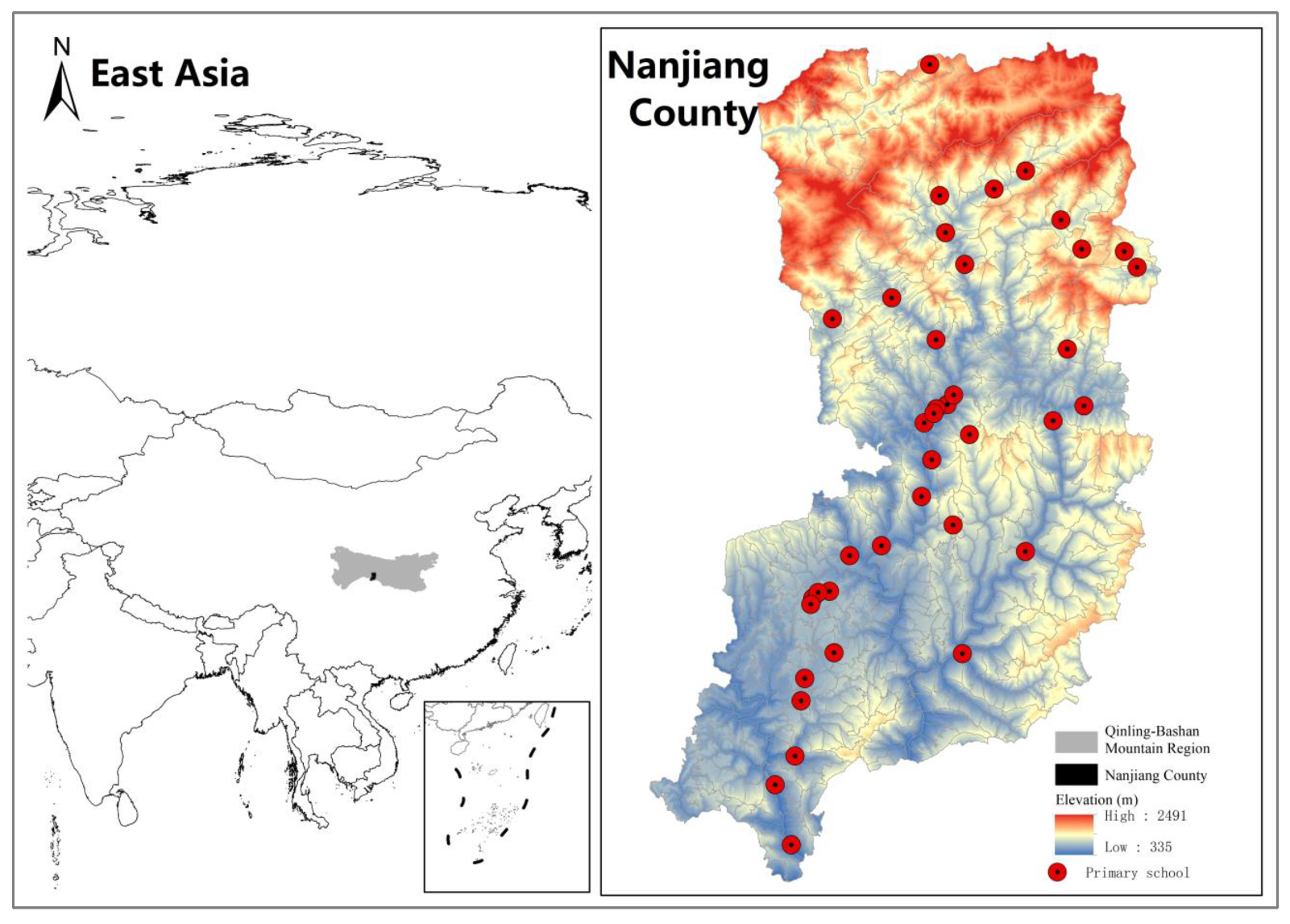
Nanjiang County is a mountainous county in the Qinling-Bashan Mountain region in southwest China. As shown in
Figure 1, Nanjiang is characterized by deep valleys and steep slopes, with elevations ranging from 335 m to 2491 m and an average elevation of 1100 m. In the northern half of Nanjiang, the topography is relatively complex, and the overall elevation is higher, while the southern half is lower and flatter. Nanjiang County has jurisdiction over 561 administrative villages or communities and has a total population of 609,000. The county was announced by the provincial government to be removed from the Chinese national poverty-stricken county list by 2019. Before rural primary school consolidation, every village in Nanjiang had a primary school, so primary school accessibility did not differ between administrative villages. From 2000 to 2005, the number of primary schools decreased from 512 to 65, a decrease of 87.30%. In the following decade, the number of primary schools continued to fall at a slower rate, stabilizing at 39 (including six-year complete primary schools and nine-year compulsory schools) in 2015. Most primary schools are distributed in low-elevation areas, and only five are above 1000 m. Meanwhile, from 2001 to 2018, road mileage in Nanjiang County increased from 917 km to 5359 km. The significant decrease in the number of primary schools and the rapid expansion of road networks, as well as the complex topographic features in Nanjiang, make it a suitable area for this study.
3.2. Primary School Accessibility Assessment
In related research, numerous studies have optimized accessibility assessment methods by improving the accuracy of the capacity and spatial-temporal variation characteristics, of services, demands, and the transportation system between them [
59,
60,
61], such as capturing the temporal variation of food service accessibility, due to the dynamics both of traffic conditions and of individuals’ intensities in performing activities at different times of day [
62]. Given this study’s emphasis on physical accessibility and the Chinese government’s nearby enrollment policy, we adopt the classical measure of travel distance impedance to the nearest school to evaluate primary school accessibility. This method assumes that residents always prefer the nearest primary school, and hence the shorter the distance, the better the primary school accessibility [
63].
Due to the constraints of rugged terrain and winding roads, traditional distance calculation methods based on plane distance may bias primary school accessibility assessment results in mountainous areas. Network and cost-distance analysis tools in digital map applications enable an accurate measurement of the real commute distance from the starting point to the destination. This function has been used by some studies on accessibility assessment in urban areas [
64,
65]. We believe this method should also be applied in studies conducted in rural areas to increase the accuracy of measurement of primary school accessibility.
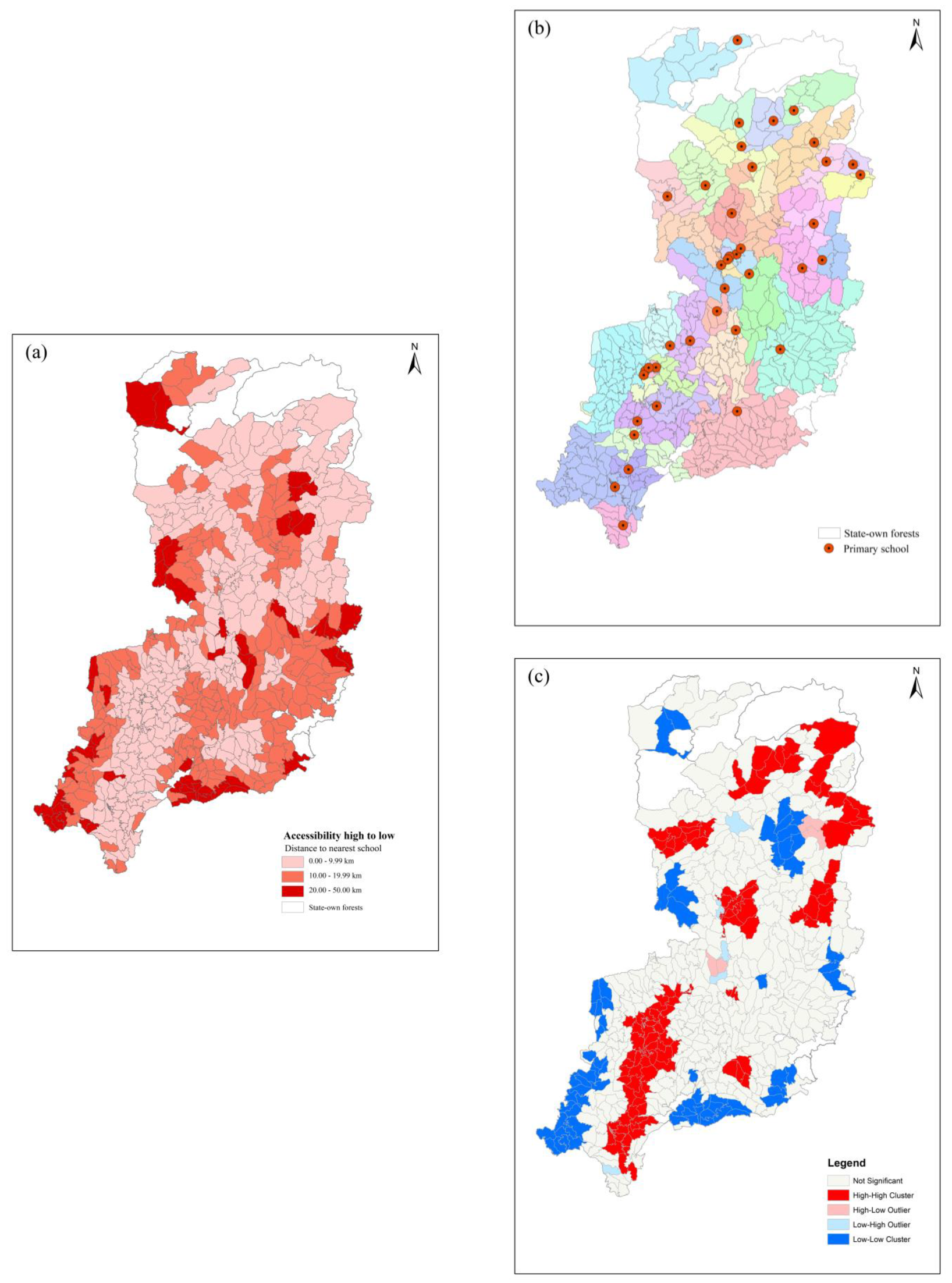
Taking the location of the committee office of each administrative village as the starting point and all primary schools as the destinations, we used the route planning function of Gaode Map (the top downloaded digital map application in China) to calculate the actual driving commute distance from each administrative village to each primary school. The geographical location information of the 561 administrative village committee offices and the 39 primary schools in Nanjiang County are points of interest (POIs) downloaded from Gaode Map. The shortest commute distance from each village to schools was identified using map service calculation results. The longer the commute distance from the administrative village to the nearest primary school, the worse the primary school accessibility in the administrative village. We then normalized commute distances using min-max normalization, yielding values between 0 and 1, with higher values indicating better primary school accessibility.
3.3. Topographic Factors and Datasets
The characterization of topographic features is a complex issue. Our literature review suggests that elevation differences and the ruggedness within villages and between a village and the nearest school are potentially important factors influencing primary school accessibility. Considering these facts, we calculated the average elevation and standard deviation of the slope of each village territory to reflect the village’s elevation and ruggedness. The elevation and ruggedness features between the village and its nearest school are delineated by a 12.5 m wide zone surrounding a straight line extending from the village committee office to the nearest school (hereafter straight zone). The average elevation and standard deviation of the slope of this straight zone are calculated to measure elevation and ruggedness, respectively. The data source for these variables was DEM data for Nanjiang County with 12.5 m pixels (downloaded from the official NASA website).
3.4. Data Analysis
To understand differences in primary school accessibility of administrative villages, we adopted the Hierarchical and k-means cluster methods to classify all administrative villages according to elevation and ruggedness, respectively. We used hierarchical cluster to determine the number and centroid of each classification and then used k-means clustering to classify administrative villages.
Exploratory spatial data analysis (ESDA) was adopted to quantify the spatial patterns of primary school accessibility. Within this broad group of techniques in ESDA, global Moran’s Index and local Moran’s Index analysis methods are commonly used. Notably, global Moran’s Index is a way to measure spatial autocorrelation, which is wildly used in geography and geographic information science to measure how closely clustered different features are. A positive and significant global Moran’s Index value indicates a general pattern of clustering in spaces with similar values. Formula (1) shows the calculation of Moran’s
I:
Note: represents the number of spatial units indexed by and , is the variable of interest (accessibility of administrative villages in the study area), and is a matrix of spatial weights.
The local Moran’s Index is used to detect the extent and location of outliers or clusters. The local indicators of spatial association (LISA) clustering map is a visualization of local Moran’s I statistic, providing a way to categorize the nature of spatial autocorrelation into four types, corresponding to spatial clusters and spatial outliers. Specifically, observations labeled in low-low and high-high represent potential spatial clusters, meaning values surrounded by similar neighbors, whereas observations labeled in low-high and high-low suggest potential spatial outliers, meaning values surrounded by dissimilar neighbors. In this study, by using Geoda software, we calculated global Moran’s I of the primary school accessibility of each administrative village in Nanjiang County and drew LISA clustering map to signify the spatial clustering pattern. Specifically, we used the first-order Queen method to define the spatial relationships between counties, meaning if two villages share the same boundary or vertex, they are defined as neighbors.
Regression analysis is an approach for modeling the relationship between a scalar response and one or more explanatory variables. In this study, we used regression analysis to explore whether and how different topographic factors influence primary school accessibility. If a significant spatial autocorrelation relationship of primary school accessibility is tested by using global Moran’s
I analysis, the spatial regression model should be considered; otherwise, non-spatial linear regression should be adopted. The spatial regression model mainly emphasizes the impact of the proximity of the studied units on the dependent variables of the units in the model. According to the influence of neighboring units, the spatial models can be divided into three types, namely, the spatial lag model (SLM), the spatial error model (SEM), and the spatial Durbin model (SDM). Specifically, SLM refers to the fact that the dependent variable of a region is affected by the independent variables of the surrounding regions. SEM, on the other hand, refers to the fact that the dependent variable in a region is affected by the unobservable error variable in adjacent regions. SDM means that the dependent variable is jointly affected by the dependent variable and the independent variable of neighboring regions. Usually, researchers use the spatial Lagrange Multiplier (LM) test and the robust LM test to test the fitting degrees of the spatial regression models. Formulas (2)–(4) show the mathematical formulas of SLM, SEM, and SDM, respectively.
Note: is the dependent variable, stands for the independent variable, and is the spatial weight matrix. represents error term. represent the spatial regression coefficients of dependent variable, spatial error term, and independent variable, respectively.
The primary school accessibility of each administrative village was the dependent variable, and the elevation and ruggedness of administrative villages and of the straight zone were independent variables of interest in the regression models. Generally, with a longer Euclidean distance, the commute distance is longer, and thus Euclidean distance between the village and its nearest school was also used as a control variable. Since primary school accessibility is clearly affected by socioeconomic factors and population [
11], socioeconomic and demographic factors were included as control variables. Village-scale socioeconomic data in China are extremely limited in availability. Hence, we used the commute distance from each village to the county seat, calculated by Gaode Map, as proxy variable for socioeconomic development conditions. Studies show strong negative correlations between distance and socioeconomic conditions; the longer the distance, the weaker development conditions tend to be [
66,
67]. We include the total population of each village, based on the population data in a 100 m grid provided by WorldPop, as demographic control variable.
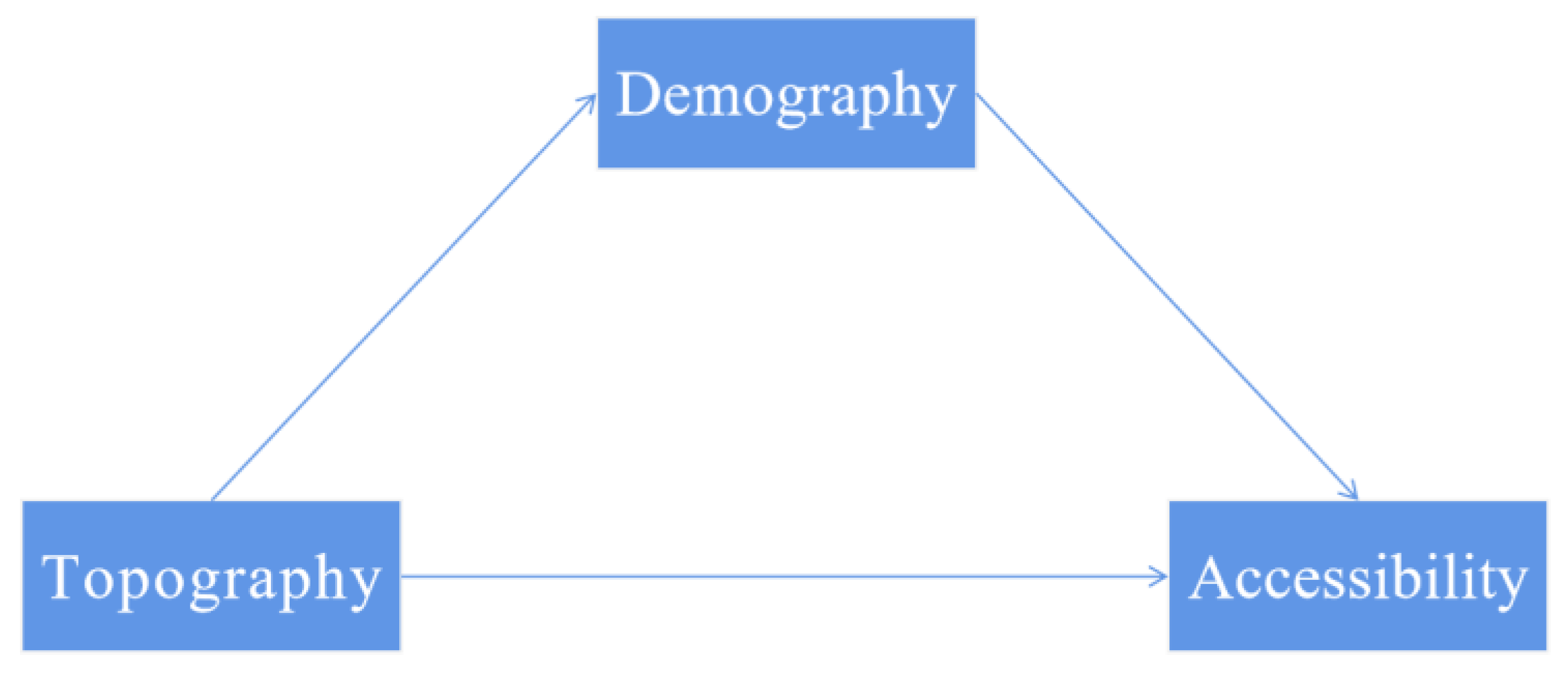
We are also interested in the potential mediating effect of population on primary school accessibility (
Figure 2). Hence, we adopted Baron and Kenny’s mediator analysis method [
68] by adding two other regression models to analyze whether the elevation and ruggedness of administrative villages and of the straight zone have an indirect impact on primary school accessibility by influencing administrative village population, conceptual formulas were shown in
Table 1.


