Abstract
The geological heritage of Australia’s landscapes and World Heritage areas has generally been underpromoted to the public by the tourism industry. However, in 2008, the fledgling world of geotourism in Australia received a significant boost with two events: the Inaugural Global Geotourism Conference ‘Discover the Earth beneath our Feet’ held in Fremantle, Western Australia, and the declaration of the UNESCO Kanawinka Global Geopark, which linked volcanic regions in South Australia and Victoria. Simultaneously the Australian Federal Government launched the ‘Australian National Landscapes’ (ANL) program. However, this impetus was not sustained when the Kanawinka Global Geopark was deregistered as a UNESCO-branded geopark in 2012, and the ANL program faded within a decade. Despite these setbacks, as an outcome of the 2008 Fremantle conference, several productive lines of geotourism have developed across Australia. This paper reviews the history of Australian geotourism since 2008. It examines the impacts of the experiences, lessons learned, problems for geology as perceived by National Parks and the Environment movement, geological communication problems, and the subsequent evolution of Australian geotourism. From these issues, new non-government bodies and initiatives have arisen, including the Australian Geoparks Network, the Australian Geoscience Council, and the recent development of a National Geotourism Strategy. Strong elements emerging from these initiatives are the increasing development of geotrails (which suit the large Australian continent) and the new Australian concept of ‘GeoRegions’. These are in response to an awareness that geotourism requires a flexible outlook to widen the appreciation and appeal of geological heritage and landscapes to the broader public. A further new direction is suggested: for Australian geotourism to combine with some elements of ICOMOS Cultural Routes. An outstanding example, the ICOMOS Overland Telegraph Line (OTL) Cultural Route that crosses Australia from south to north, is considered. For 2000 km, the construction of this line in the 1870s followed the regional geology and hydrology, relying upon the available biota but bringing about a clash of human cultures. The six colonies of Australia were finally linked to the world by wire, but the arrival of the OTL had a significant impact on the country’s Indigenous inhabitants. In Australia and globally, geotourism is incorporating the A–B–Cs (abiotic, biotic and cultural elements) to more effectively encourage the public to value their landscapes and the associated stories. The OTL provides an example of a newly introduced fourth dimension for geotourism, which gives consideration to the socio-political context of landscape adaptation.
1. Introduction
1.1. Geotourism in Australia
Having been developed from an idea initially conceived in Britain a decade earlier, the discipline of ‘Geotourism’ was publicly introduced into Australia in 2008 at the Inaugural Global Geotourism Conference held in Fremantle in the large and geologically diverse state of Western Australia. This coincided with the inauguration by UNESCO (United Nations Environment and Scientific Cultural Organisation) of the Kanawinka Global Geopark, which spanned portions of two Australian States: southeastern South Australia and western Victoria. This was the first global geopark in the Southern Hemisphere. Impetus for the Kanawinka Geopark was gained three years earlier in 2005 following the publication of the book Geotourism, written by two Australian authors [1]. By combining geomorphology, geology and tourism business platforms, the book introduced Australia to the world of geotourism and geoparks. The landscape of the Kanawinka Global Geopark (referred to as Kanawinka in this paper) was designated due to Indigenous and settler interactions with its extensive volcanic sites: a combination of geological and cultural features, which are fundamental components of geotourism. As such, it generated much interest within Australia as it moved the concept of landscape-based tourism beyond conventional tourism promotions of the Australian continent.
An important aspect of geotourism was enunciated at the Fremantle conference by keynote speaker Elery Hamilton-Smith, who stated that “Geotourism is too important to be left in the hands of geologists!” [2]. However, this idea was slow to be embraced by the geological profession: e.g., ‘Geotourism… has geology as a central focus and embraces geological tourism for dedicated geotourists’ [3]. Geoparks have bloomed in China where geotourism is termed ‘Tourism Earth-Science’. In China, there has been a ‘focus on geology in combination with ecology and culture’ [4], which is synchronous with UNESCO’s geopark ethos. Both forms have a focus on local community development. In the USA, there are no geoparks, but there is an outstanding National Parks network. Geotourism ‘enhances the distinctive geographical character of a place—its environment, heritage, aesthetics, culture and the well-being of its residents’ [5]. In Australia, this broader approach has been developed to include the abiotic, biotic, and cultural elements (A-B-Cs). ‘A’ includes the climate, sky, landscape and geology; ‘B’ encompasses flora, fauna and ecology; ‘C’ refers to Indigenous, historical and community cultural elements. Recently it is being referred to as ‘Geodiversity’, although this is a contested terminology [3]. More recently, a fourth dimension has been suggested, which considers the socio-political context of landscape adaptation [6]. Put simply, ‘Geo’ means ‘Earth’, not ‘Rocks’, and it applies to the planet. Geotourism embraces the full spectrum of geology, botany, biology, first nations, later settlers, land development and communities [7]. In semi-arid Australia, the A–B–C approach is exemplified in the new Western Australian geotourism initiative of the Murchison GeoRegion [8].
Prior to the advent of geotourism, ‘for many years Australia was recognised internationally as a leader in the field of geological heritage documentation and conservation’ [9] due to the efforts of many members of the Geological Society of Australia (GSA) in its subcommittees of all state divisions. However, concerns about the nation-wide trend for tertiary undergraduates to seek enrolments in the broader environmental sciences rather than earth sciences and geology prompted initiatives to popularise these fields. By drawing upon its many geoheritage sites, geotourism was one tool that was perceived as capable of achieving this goal by reaching out to the broader public through tourism and education [7]. Where the term ‘geotourism’ is used in this text, it variously refers to the discipline itself, to the concept, or to the group of Australians who are working within it to develop and advance it.
1.2. Australia’s Natural Attractions and Image
Geotourism is now becoming a better-established concept [7]. While there is an emerging acceptance among the various geological disciplines, in broader Australian tourism circles, geotourism enjoys only preliminary or incremental awareness. This is ironic, as the most successful driver of the nation’s primary tourism marketing focuses on its regional development, nature-based tourism and the nation’s outstanding natural features. ‘The Natural Environment…attracts a lot of interest from out-of-region travellers and represents a strength for Australia compared to most other destinations’ [10]. The Great Barrier Reef and the great red rock of Uluru at the continent’s centre have been the dominant images of the travel promotions of Australian tourism and of Qantas, the prominent international airline that is identified specifically with the Australian continent [10,11] (Figure 1). In more recent years, Kakadu National Park’s dramatic cliff country in the Northern Territory and images of Tasmania in the cool temperate south have become internationally recognised. Tourism Australia statistics indicate that ~9 million international visitors arrive in Australia each year. In combination with domestic travellers, 44% visit non-urban regions (see Section 3.2). The Red Centre with Uluru is the most popular destination. In other words, Australian tourism promotion is geotourism!
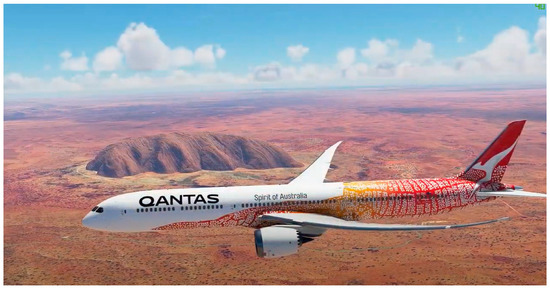
Figure 1.
QANTAS aircraft painted with Indigenous artwork flying by Uluru/Ayers Rock at the centre of the Australian continent; this constitutes outstanding aerial geotourism. Image reproduced with the permission of Tourism Australia. Sources [10,11].
1.3. Australia’s World Heritage and Limited Promotion
A number of these celebrated outstanding landscapes are designated as World Heritage sites (Figure 2). Those of striking visual geomorphological attraction are Uluru, Kakadu, Purnululu, the Great Barrier Reef, Fraser Island, Lord Howe Island, the Blue Mountains, Willandra Lakes, the Tasmanian Wilderness, Naracoorte Caves/Riversleigh fossil sites, the Ningaloo Coast and Reef, Heard and McDonald Islands, and Macquarie Island, all of which exhibit extensive abiotic attributes—the ‘A’ of A–B–C. The biotic (‘B’) attributes are strongly represented in the other World Heritage natural sites of the Wet Tropics, Gondwana Rainforests, Macquarie Island and Shark Bay. While the cultural (‘C’) attributes cover a collection of colonial/convict sites (none in free-settled South Australia!), four of the geological sites above are designated as ‘Mixed’ World Heritage sites as they combine outstanding landscapes containing major Indigenous components: Kakadu, Uluru, the Willandra Lakes, and the recently listed Budj Bim cultural landscape [12].
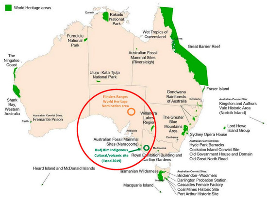
Figure 2.
Natural and Cultural World Heritage areas of Australia. The red circle contains the recent Budj Bim listing in Western Victoria and the Flinders Ranges in South Australia, which are currently with UNESCO for tentative listing. Adapted by the author in 2020 from the original source map (now unobtainable). Permission to adapt was provided from the Australian Department of Climate Change, Environment, Energy and Water. Source [7].
The first Australian World Heritage designations were Kakadu National Park (Northern Territory) in 1979 and the Great Barrier Reef (Queensland) in 1981. While the natural character of the Australian continent has become identifiable through some of its outstanding World Heritage natural sites, it is ironic that there continues to be little publicity in tourist advertisements, enticements or literature that acknowledges their World Heritage status. This deficiency extends to a lack of identification with and appreciation of the actual geoheritage elements of our World Heritage sites. For example, the Shark Bay World Heritage area in Western Australia is identified for its ‘B’ (biotic) values, but it has outstanding coastal geoheritage attributes of global importance [13] that are rarely mentioned. In Australia, World Heritage is highly valued and sought after but appears to be considered more as a status and conservation responsibility, rather than being elevated for marketing purposes across the tourism industry.
Thus, an opening appeared for alternative programs to promote Australian landscapes for tourism and public appreciation. A different UNESCO designation for Global Geoparks had been expanding rapidly on other continents and led to the initiative of the Kanawinka Volcanic Geopark, a significant step forward in Australian geotourism [14]. The experience of the establishment and deregistration of the UNESCO Kanawinka Geopark and the subsequent assessment of its strengths and weaknesses has shaped Australian geotourism initiatives significantly throughout the last decade. These issues are addressed in the following discussions.
2. UNESCO Kanawinka Global Geopark: De-Listed but Geotourism Lessons Learned
2.1. Australia’s First Geopark
This first (and only) former Australian geopark grew from a ‘Volcano Discovery Trail’ across the Newer Volcanics region, a vast plain of ~400 extinct monogenetic volcanoes, lava flows and crater sites ranging in age from 5 Ma to ~5 ka (Figure 3). The park was intended to capture tourist traffic between the adjacent Great Ocean Road (GOR) in the south and the natural attractions of the Grampians Ranges to the north. The nomination process was initiated in 2005 by Professor Bernie Joyce and Dr Susan Turner. It was guided by inaugural Director Joane McKnight to affirmation as the 57th global geopark at a UNESCO geopark conference held in Germany in 2008 [15]. Kanawinka Geopark proceeded successfully for four years with the financial support of seven cross-border councils and shires in South Australia and Victoria, and two other neighbouring but non-contributing shires. At 400 × 150 km, Kanawinka was the largest geopark on the planet and all the other 56 geoparks of that time could fit into one corner of it. A framework paper was published on its establishment, content and marketing [16], and Kanawinka was represented at several international conferences (Germany, Malaysia, Hong Kong, Brisbane and Perth). In 2011, Bernie Joyce, Grant Humphries and incoming Director Ian Lewis expanded the information on 60 geosites by integrating volcanics, karst, wildlife, history and culture into the geopark framework (Figure 4).
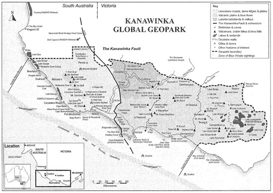
Figure 3.
Multiple geosites across the Kanawinka Geopark. The Karst Plain is to the west and the Volcanic Plain is to the east of the central Kanawinka Fault. Source [16]. Image reproduced with the permission of the author. Geosite descriptions are in the detailed ‘Kanawinka Geotrails’ map brochure [Supplementary S1].
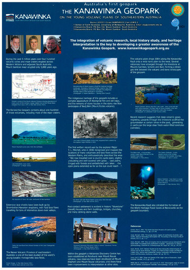
Figure 4.
Kanawinka Geopark poster demonstrating the A–B–C elements associated with the volcanic and karst landscapes (Joyce B, Humphries G and Lewis ID 2012). This poster image is also included as a grateful tribute to the late Professor Bernie Joyce. Photographs courtesy of Mac Web Services except where otherwise stated. Small text is readable upon enlargement.
2.2. De-Listing and Rebirth
Unbeknown to the Geopark Directorate, lobbying and resistance from the mining, agriculture and National Parks industries was due to the perception of a UNESCO geopark (incorrectly) as another layer of restrictive environmental regulation or, alternatively, as a competitor for state and federal funding. These perspectives were deeply misguided: the geopark was a community-based operation with no legal powers, promoting visitation into the region. At the same time, state and federal environment ministers were concerned that formal Australian (host) government approval had not been obtained by UNESCO or the Kanawinka nomination team through the correct diplomatic channels prior to the geopark’s establishment in 2008 [9,17]. This combination of events led to a formal instruction by the Australian government to UNESCO inspectors in 2012 that they were not permitted to undertake the four-yearly geopark review, which was due that year. This obliged UNESCO to delist Kanawinka as a global geopark, much to the disappointment of its supporters. Geopark #57 has remained globally unassigned and no geoparks have appeared in Australia since, despite some attempts in other regions in recent years [18]. However, due to the geopark’s public popularity, supporters were determined not to lose its name, concept and brand identity in the tourism and geological worlds, considering its possible future reinstatement. Therefore, as director, Ian Lewis renamed it as ‘Kanawinka Geotrails’ and redesigned the map brochures (see the detailed Kanawinka map brochure [Supplementary S1]). To date, 200,000 of these brochures have been distributed from the 25 Tourist Information Centres across the region. The renaming and the updated map had a positive influence in expanding the concept of geotrails in Australia, which are addressed later in this paper, and the ‘Kanawinka Geotrails’ continue to this day [19].
2.3. Assessment of Kanawinka’s Strengths and Weaknesses, 2008–2012
In the decade since Kanawinka, lessons have been learned. There have been some claims that the Kanawinka Geopark ‘failed’ [20] (and T Raimondo: personal communication in presentation ‘Hot Rocks, Ice Sheets and Melted Crust’ to Field Geology Club of South Australia, 3 October 2019). Such claims are incorrect; Kanawinka functioned fully and effectively for four years until it was undone by circumstances beyond its control. However, from informal reviews by its supporters and the Geotourism Standing Committee of the Geological Society of Australia (GSA), a number of insights have emerged:
2.3.1. Positives
- A useful, popular and informative map was adapted and produced, elevating knowledge and awareness of the Newer Volcanics, the Gambier karstfield and the Geopark ethos [Supplementary S1];
- Interactions with local communities and schools were instructive and stimulating;
- Links with some Indigenous groups (Gunditjmara and Girai Wurrung) have extended the community’s awareness of the region’s pre-settlement cultures;
- The support of the seven local councils/shires (Corangamite, Moyne, Southern Grampians and Glenelg Shires in Victoria and Mount Gambier, Grant and Wattle Range Councils in South Australia) showed that cross-border cooperation for a large nature-based region is possible;
- The recognition of the large karst component of the geopark and the geology of the central Kanawinka Faultline itself doubled the geoattractions available [16];
- The presence of UNESCO branding brought attention to the region and provided economic benefit [16];
- Communication and promotional links with the adjacent World Heritage Naracoorte Caves Fossil Site strengthened UNESCO connections [16];
- The publicity of Kanawinka boosted visitation to the region, generated a major documentary of the Mount Gambier volcanic complex, increased the usage of the Penshurst Volcanoes Discovery Centre and Tower Hill Interpretation Complex, and stimulated the construction of the Mount Elephant Volcano Interpretation centre;
- The geopark ethos and emphasis on the abiotic/biotic/cultural heritage aspects (referred to in Section 1.1 and Section 1.2) was particularly valued by the community.
2.3.2. Negatives and Oversights
- Kanawinka, being only supported by seven local Shires, had to compete for tourism visitation with the adjacent Great Ocean Road (GOR) region, which was heavily supported by the Victorian Government’s tourism initiatives.
- Some of Kanawinka’s local shires and councils only made expenditure available for promotions within their own boundaries.
- Some local shires and councils slowly withdrew their financial support over the four years, but Kanawinka had been relying upon the equal funding that had been committed by the contributing agencies.
- The geopark was supported by only one city (Mount Gambier, population ~30,000 and with a major nationally renowned volcanic complex containing the famous Blue Lake) and a series of small towns that were generally ~50 km apart. The other city of ~30,000, Warrnambool, is self-contained as its own separate urban shire within the Kanawinka boundaries. However, it chose from the beginning not to support Kanawinka but rather the nearby Great Ocean Road region instead, with which it more readily identified as a coastal city, despite outstanding nearby volcanics at Tower Hill.
- The distance between small communities at different corners of the large region and their localised travel patterns meant that their familiarity with, and thus their support for, distant features of the geopark was low as a direct result of Kanawinka’s size.
- The external resistance to Kanawinka referred to in Section 2.2 above was unknown to the committee or the committee would have made direct representations to the Federal Government and learned of their concerns. We were not forewarned.
- The Federal Government’s concerns referred to in Section 2.2 above exposed deficiencies of due diligence by UNESCO in its 2008 Kanawinka approval process [9]. UNESCO is understood to have subsequently addressed such procedures in that regard.
- No Indigenous representatives, now a vital element of global geoparks, were on the Kanawinka committee. Some Kerrupjmara elders shared some volcanic landscape stories with Kanawinka in a successful outreach; however, to the Gunditjmara people the Kanawinka Global Geopark was a concept which did not have relevance for them. Their focus was on gaining World Heritage Cultural Landscape status for their local Budj Bim volcanic country, which was achieved a decade later (Figure 2 and Figure 4).
- The Kanawinka Geopark Committee members were not made aware of the necessity of support of the South Australian and Victorian State Governments’ geological agencies for the approval of a geopark.
2.4. Realisations and Insights
2.4.1. Size
Kanawinka Geopark was the size of some smaller European nations e.g., Belgium, Switzerland, Holland and Denmark. Its sheer area of 400 x 150 km dwarfed all the other geoparks before and since. Meeting costs were sizeable for a committee of ten from across the whole region. Priorities of the seven supporting shires and councils often differed according to their locations, some separated by considerable distances. The older, more eroded and subdued Australian continental landscape leads to geoheritage sites of significance distributed over larger areas, requiring significant travel. This is an important problem facing Australian tourism promotion [6]. By contrast, the European geopark model of a small area adjacent to a large city population (e.g., 500,000) is a much easier focus for finance, coordination, engagement of its supporting population and the involvement of a relatively nearby national government.
2.4.2. Large Nations and Landscape Decisions
Smaller European nations and their geoparks contrast to large-area democratic federations with nation-sized states or provinces (e.g., Canada, USA and Australia), where these second-order governments make many decisions independent of the federal legislature, almost like semi-independent nations. As an example, the Australian states still view the National Government with some reserve and each other with the same competitiveness as at the time when each was a separate colony prior to the Federation in 1901. UNESCO geoparks’ management in Paris during Kanawinka’s time (2008–2012) were not very aware of or experienced with how a large, federated nation operates around the substantial powers of its semi-independent states or provinces, as there were no other geoparks in such nations then. Geoparks were much more readily attainable in the centrally governed nations of China and across Europe, where the other 56 geoparks were concentrated in Kanawinka’s time.
2.4.3. Relationships with Neighbouring World Heritage Areas
Adjacent to the Kanawinka Global Geopark lies the UNESCO World Heritage Naracoorte Fossil Caves site. Its council region was not approached to be part of the geopark during initial planning as it is not in a volcanic zone. On reflection, its extensive karst characteristics would have been a most appropriate inclusion with the western Kanawinka karstfields in South Australia. Nevertheless, Kanawinka Geopark maintained ongoing active contact with Naracoorte and now as a Geotrail network continues to promote the association between the two tourism and research bodies to the advantage of both.
By contrast, there was minimal contact between Kanawinka and the Budj Bim Indigenous volcanic area contained within its western volcanic zone. This outstanding landscape consists of a large lava field from Budj Bim (Mount Eccles) volcano, which first erupted ~30,000 years ago with a subsequent flow ~8000 years ago, which dammed Tae Rak (Lake Condah). This was an event witnessed by the Gunditjmara ancestors [21]. This allowed them subsequently to utilise the broken lava stones to develop a now well-documented settled aquaculture of stone huts and eel traps near the coastline from ~7000 years ago onwards and to exploit the rough lava landscape using defensive tactics in the ‘Eumeralla Wars’ of resistance against the encroaching European settlers [22]. The remains of many small circular lava stone huts are still seen after being destroyed by European settlers to build drystone walls when the ‘enclosure’ of land began. This is now the Budj Bim Cultural World Heritage area. The attainment of this status by the Gunditjmara people over a decade of concentrated efforts has reinforced in their people a proud independence of spirit and their own pathway forward, including funding. Interaction between Kanawinka Geotrails and Budj Bim was minor and ideally this should have been actively strengthened. Contact now is still sporadic although both bodies benefit from the tourism promotion activities of either, drawing attention to the region. Kanawinka Geotrails are extremely fortunate to have two World Heritage areas (one Natural, one Cultural) within its neighbourhood with which to encourage geotourism visitation of this rich and diverse region.
2.5. Subsequent Australian Geopark Attempts and Australian Attitudes to UNESCO
Since the de-listing of Kanawinka Geopark, the number of UNESCO global geoparks has tripled, spanning all habitable continents except Australia (195 in 48 nations) [23]. In Australia, however, UNESCO advice and activities have not always been so successful. An informal UNESCO appraisal of Arkaroola Sanctuary, a privately run conservation and arid tourism operation in the northern Flinders Ranges of South Australia, advised it to be unsuitable as a geopark prospect despite being a spectacular mountain area with unique ancient geology and iconic South Australian mining settlement history, attracting great ongoing research interest. UNESCO would require a notable Indigenous role and input (McKeever P: pers comm 2017), a value which was not required strongly for Kanawinka ten years prior. Arkaroola had been in contact with the nearby Adnyamathanha Indigenous people over several decades, but an operative relationship never properly developed. The informal verdict was a setback for Arkaroola and a cause for contemplation and re-evaluation for any who envisaged future Australian geoparks.
A few years later, UNESCO’s criticism of Australia’s alleged mishandling of the condition of the World Heritage Great Barrier Reef (GBR), encouraged by Australian environmental activists, was poorly received by the GBR tourism industry for what was basically perceived as unsubstantiated criticism, and quite widely nationally by a feeling that UNESCO has only a limited role in telling Australia what to do with its own natural assets. The response generated, in areas of the Australian public, an element of national reluctance towards UNESCO which still persists. Additionally, agricultural interests in the settled south of the continent around the Kanawinka region accepted the UNESCO geopark, but this is certainly not so in the wide-horizon large pastoral and mining north. This has led to the failure of two aspirational geopark initiatives in Outback Queensland (Etheridge) and the agricultural country of northern NSW (Warrumbungle). Further, a long-running attempt to initiate a UNESCO Cultural Landscape designation for the Mount Lofty Ranges and Barossa Valley in South Australia has dissipated over the last two decades for lack of sufficient sustained community support. Since around 2017, several initiatives for ‘pre-‘aspiring geoparks on either side of the continent have been proceeding with varying intensity and some inconsistency, requiring a long time frame ahead for any eventual success at UNESCO level. Regarding geotourism, there is some ongoing contact between UNESCO and several Australian geotourism bodies (AGN and AGC, discussed in Section 6.2 and Section 6.3 below.
3. Australian National LANDSCAPES
3.1. Sixteen National Landscapes but without Kanawinka
Whatever the reasons for World Heritage not being very actively promoted in tourism programmes, at the same time as plans for the Kanawinka Geopark were being submitted to UNESCO by a voluntary organising committee in 2005, the Australian Government was initiating a somewhat similar concept of its own, named as the Australian National Landscapes (ANLs). This involved selecting regions with distinctive natural characteristics, generally from National Parks, and combining those resources with tourism promotion. It differed from geoparks as it was a ‘top-down’ government-driven program devolving management to local regions rather than a community-driven initiative. The first of sixteen ANLs was Australia’s Red Centre National Landscape, launched in December 2006. Subsequently mostly coastal and forested ANL’s were designated. They included some World Heritage areas: the Great Barrier Reef, Wet Tropics, Blue Mountains, Tasmania, elements of the Red Centre, Ningaloo-Shark Bay, but moved significantly beyond these to cover coastal zones, old volcanics, and arid and tropical rangelands that were not nominated for World Heritage (Figure 5).
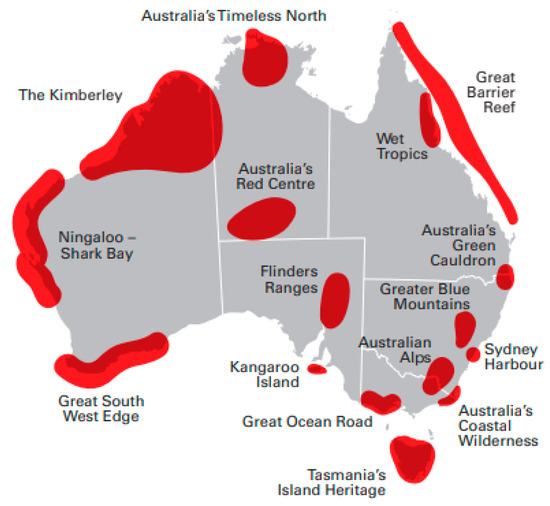
Figure 5.
Australian National Landscapes: Image by permission of the Australian Department of Climate Change, Environment, Energy and Water. Sources: [24].
However, the 16 ANL’s did not include the Newer Volcanics/Kanawinka region. This is located across the entire section of the Great Ocean Road (GOR) outlined above (Figure 5): the GOR is explicitly the very coastal edge alone. The omission of iconic landscape regions, such as Kanawinka and the vast Nullarbor Plain, may have been from a perception of limited tourism visitation densities. While this was so, ANL aims and criteria had an interesting similarity to the aspirations of geoparks, quite a coincidence of timing and purpose in 2005, which is the year of Kanawinka’s conception. ANLs also had a similarity with the more recent concept of GeoRegions (discussed below). All three of these landscape management forms (Geoparks, ANLs, GeoRegions) represent a sequential evolutionary path of geotourism ideas developed across Australian regions in the last decade.
3.2. ANLs Reasons and Aims
ANLs were conceived to broaden public appreciation for Australia’s outstanding natural features but also to utilise these features to generate more visitation-based revenue. The Australian government drove the ANL initiative via a combination of two federal agencies, Tourism Australia and Parks Australia, tasked with a mission to encourage cooperation between tourism promoters, private enterprise, various state and local government departments and park authorities, conservation organisations and Indigenous groups. This was part of a longer-term strategy, which required the tourism and conservation sectors to coordinate in a manner and to an extent not previously attempted, based on a concept of a vital link between tourism and conservation.
It aimed to make Australia’s 9000 national parks, protected areas and reserves “digestible” for domestic and international visitors [24].
The Programme aimed to promote the conservation of Australia’s natural assets while raising awareness and visitation to Australia’s premiere culture- and nature-based destinations that deliver memorable holiday experiences to the international ‘Experience Seeker’ target market [Supplementary S2].
In a notably similar approach to that of Kanawinka Geopark and geoparks in general, a combination of ‘nature and culture’ [25] was identified for the ANL program as being attractive to the tourist market beyond that of natural landscapes alone. It might even be contemplated that ANLs were conceived to be the Australian government’s equivalent of geoparks. To cater to a wide range of tourism experiences across these landscapes, ANLs were required by an evaluation board to have cultural components, not just natural features:
National Landscapes promote and support the conservation of some of Australia’s most distinct and rich environments and raise the profile of the natural and cultural tourism experience in Australia [26].
The federally driven ANL programme placed a greater emphasis on tourism than conservation and provided a series of objectives for elevating training and interpretation across the industry:
- Provision of formal yet sensitive training for interpreters;
- A certification process leading to formal qualifications;
- Establishing and maintaining consistent quality of nature tourism standards;
- Providing a programme with the capacity to be managed by nature tourism practitioners.
The partnership between Tourism Australia and Parks Australia was an opportunity taken by the Australian Government to utilise the public relations capacity of tourism with the (subsidised) landscape assets of national parks. It was an attempt to generate increased public revenue from both departments through more visitation, including promoting international tourism and, in particular, targeting the burgeoning Chinese tourism market in Australia at that time. As the decade progressed, federal ANL aims were extended to boosting the role of national parks’ contribution to regional (mainly rural) communities by improving access utilities. This enhanced the concerns of conservationists, ecologists and rangers who perceived further pressure on conservation areas and national parks resulting from an increase in tourism ventures. In an endeavour to partially allay such concerns, the program rather hopefully ‘‘encourage[d] all elements of the tourism industry to undertake conservation initiatives that improve the visitor’s experience and contribute to the environment’ [27].
For five years, 2012–2016, nature-based domestic, international and day tripper visitor numbers in Australia rose by 41%, 49% and 62%, respectively. In that period, all sixteen ANLs generated $18 billion, of which $6 billion came from Tasmania, GOR and the Greater Blue Mountains, all located close to the large population sources of Sydney, Melbourne, and Hobart (Figure 5) [28]. This also provided an increase in employment in the National Landscapes regions.
Most National Landscape areas (except for two [Red Centre and Ningaloo]) have seen an increase in employment over the past five years. For example, on average the GOR created an additional 894 new jobs each year between 2012 and 2016 … These jobs are particularly important for the more remote areas, where non-tourism related jobs are limited [28].
3.3. Outcomes and Limitations
The ANL programme had some initial successes. A prominent one was the Great Ocean Road (GOR) landscape southwest of Melbourne, Victoria, themed around spectacular cliffside views along the coastal road itself, which had commenced construction by returning World War One soldiers as a war memorial and was completed as a re-employment strategy in the Great Depression years. The GOR ANL received strong local support and from the Victorian government as a flagship tourism attraction, also receiving many direct flights from China into the State capital, Melbourne, nearby. The marketing of this ANL placed emphasis on its strong combination of natural and cultural elements: geology, marine environment, history, and its outstanding and dramatic coastal scenery [29]. In areas of the Tasmania ANL, natural tourism sites abound, and high-end hiking experiences flourished. These were complemented by multiple historic convict sites and lifestyle aspects: food and wine at Salamanca Place wharf, the Antarctic Mawson’s Hut Museum, and the renowned Museum of Old and New Art in Hobart (MONA). The beautiful Greater Blue Mountains were very popular, being a day drive from Sydney, Australia’s largest city [30]. In the Red Centre and Timeless North ANLs, several Indigenous communities have been able to develop very successful and popular tourism initiatives at Uluru and Standley Chasm.
After eight years of operations, a review of ANLs was undertaken in 2016 by the Tourism Transport Forum (TTF). The following observations were compiled by the report’s authors [31]:
- The assessment revealed a varied range of ANL performances of which Tasmania was the standout ANL.
- Many others performed with varying success, in part due to the level of investment that their governments were making in promoting and improving their key natural assets, as well as relative distance from major population and international tourism gateways.
- Many of the National Landscapes featured in this report [are] isolated, only accessible by infrequent flights or long car trips and have limited options for people to stay in hotels or do things when they get there. This makes them unattractive places to visit, especially for international visitors.
- The National Landscape areas still have a low proportion of visitors that come from overseas. Indeed, 10 of the 16 areas have a single digit proportion of visitors from overseas.
3.4. Management and Funding Issues
3.4.1. Management/Delegation
Pointedly, the federal ANL program did not provide on-site leadership, just a framework and the initial impetus. From the outset, each National Landscape had to take responsibility for organising and running its own regional steering committee. These managed the coordination of multiple local stakeholders: shires, national parks, volunteer groups, Indigenous representatives, conservation and tourism bodies. ‘Since 2014, the Chairs of the Steering Committees [have] had complete ownership of the Program’ [26].
3.4.2. Promotion
Similarly, the federal ANL program did not provide localised advertising or promotion to each ANL as it was focused internationally. Instead, it compiled criteria for each ANL to identify for themselves their best iconic natural and cultural experiences within each landscape. The individual ANLs had to rely upon the promotion provided through Tourism Australia’s digital, social and public relations channels or also fund their own. The national coverage was not focused on visitors from within each ANL or the nation. Instead, it was aimed primarily at the international ‘experience seeker’ market to visit landscapes in Australia. The latest Tourism Australia post-COVID international promotion is ‘Australia - Come and Say G’Day’ with cartoon characters Ruby Roo and Louie Unicorn travelling by magic to the same primary tourism sites: the Great Barrier Reef, Uluru, and the Sydney Harbour Bridge and Opera House. This lightweight marketing approach may be attractive to some in its way, but after so much effort by the local ANL organisations, it makes no mention of ANLs at all, nor even the concept. Neither has there been mention of the interpretation of landscapes, or inclusion of geotourism, despite the emphasis of landscape imagery in the tourism promotions.
3.4.3. Funding Deflection
Of most concern, however, was that the ANL program was never intended to deliver funding from a central (national) source. It was announced with the intention that each ANL seek its own funding and support from local, state and regional sources to attempt to accomplish the following (summarised from [28]):
- Improving facilities, maintenance and high quality visitor services;
- Delivering diverse world-class nature-based experiences;
- Marketing their nature tourism attractions in a competitive global market;
- Coordinating stakeholders, including private investors;
- Developing sustainable business and employment opportunities for Indigenous traditional owners when sought and supported by their local communities.
3.5. Handover of ANLs to Ecotourism Australia
The regional steering committees performed variably, particularly those located at a significant distance from large accessible populations. The high level of quality that was expected needed considerable resources, commitment and effort. These requirements for some ANLs were foreseen as potentially difficult to reach:
… most National Landscapes can be described as high visitation and bio-diverse. This implies a need for high quality visitor management and outstanding environmental management, supported by initial and ongoing funding. In the absence of clear funding mechanisms, it is unlikely that the longer term environmental or socio-economic objectives of the Program will be achieved [32].
Tolkach et al. (2016) [32] conducted a detailed marketing assessment of the ANLs, followed in 2017 by the TTF review [28], both after almost a decade of the ANL program’s implementation. Subsequently from around that time, however, the profiles of ANLs began to diminish from public view. This coincides with the Australian Government deciding to cease overseeing the ANL program and to hand it over to a non-government agency. This appears to have been as planned initially but may have been also influenced by a sudden significant reduction in the Chinese visitor numbers arising from national political factors but occurring several years before COVID spread across Australia.
Ecotourism Australia (EA) was targeted as the successor to manage the national ANL program. EA is a long-established not-for-profit organisation based in Queensland, providing eco-certification programs across Australia through ~500 tourism agencies [33]. It partners with Parks Australia and the National Parks of Queensland, Victoria, Tasmania, South Australia and Western Australia. Surprisingly, it does not partner with New South Wales, which is the biggest State tourism market. The handover occurred without any fanfare around 2017–2018, with a small start-up payment from the Australian Government and a requirement that each ANL make a monetary contribution to EA; however, the ANLs chose not to respond to this arrangement, so eventually, EA let the ANL program go and took the ANL references off their website. The landscapes remain geographically but the ANL program and branding have now disappeared.
During its few years of ANL stewardship, EA was exposed to geotourism at their various seminars and at their Global Eco Asia-Pacific Tourism Conference in Adelaide, South Australia in 2017; however, EA showed only little interest in embracing this extra dimension of landscape interpretation and allowed the concept to diminish within their organisation. It was felt by geotourism supporters that this was a lost opportunity. EA may also have been discouraged by an earlier decision advised by Tourism Australia in 2010 ‘that it has not looked into the field of geotourism and will not be in the foreseeable future’ [9].
3.6. ANL Achievements and Disappointments
The ANL Strategic Direction Pyramid released at inception scheduled a series of milestones [26]:
| 2005–2009 | Awareness of local stakeholders and developing strategies. | |
| 2010–2014 | Setting the Foundation: priority projects, products and marketing. | |
| 2015–2017 | Seeing the Results: trade awareness, increased technology and employment. | |
| 2018–2020 | Achieving Potential: global recognition of ANL’s; increased tourism patronage. |
By 2017, ANLs had ceased to operate in a form recognisable from their original concept and initiation a decade previously. Reports for each National Landscape are now out-of-date by six years or more and have been removed from the Tourism Australia website [34].
It is very regrettable that only some of the pyramid’s objectives were achieved. The ANLs that progressed were Tasmania, GOR and Blue Mountains as they had received substantial state government and solid local population support in several forms. They continue to succeed very well, beyond the days of the ANL brand. The 2017 TTF survey [28] revealed the performance imbalance between these and the other 13 more remote ANLs. As an example, in the Flinders Ranges ANL in South Australia, great efforts were undertaken by the local ANL Steering Committee led by Lorraine Edmunds to produce a detailed concept and action plan for the region entitled ‘Mountains of Memory’ [35]; however, very little funding was made available and the plans lapsed, so years of hard and enthusiastic work by that community subsided and then evaporated, leaving the proponents of the ANL and their many supporters feeling discarded. These problems with nation-wide initiatives for large semi-remote regions were foreseen during the second pyramid stage [36]. They have a similarity (at a subcontinental scale) to the problems discovered across the large Kanawinka Geopark region: distance, finance, small community size and marketability. Landscape size and distance is a particular Australian demographic problem for geological regions and for geotourism itself [37].
However, the ANL program and concept deserves credit for its ambitions:
Australia’s National Landscapes Program presented an opportunity for previously under-funded and under-resourced remote and rural cultural and heritage sites to develop attractive tourism products that educate visitors about the rich history and culture of Australia and preserve local heritage for future generations…
It [was] arguably the world’s largest and most ambitious of its kind. Most previous studies on collaborative destination management that have been mentioned [in this paper] have been based on individual tourist destinations rather than on nation-wide frameworks. In this context, the Australia’s National Landscape Program [provided] a unique opportunity to investigate the issues confronting a collaborative destination management approach in the context of a multi-level (federal, state and local) political system and inter-state environment where the various landscapes are located in distinct socio-economic, cultural and ecological environments [32].
For the ‘Mountains of Memory’ region, there has recently been a more positive outcome. The South Australian government has activated a nature-based tourism policy that has led to the current preparation of a nomination of the Flinders Ranges for World Heritage status, in part, drawing upon the excellent work of the earlier ANL Steering Committee a decade previously. Geotourism for the Flinders Ranges is evolving but with a change of direction.
4. Regional Development Australia (RDA), SEGRA and Private Landscape Initiatives
Geotourism has more recently been represented within two Australian semi-voluntary organisations whose primary focus is to promote development and progress across rural regions independent of the nation’s seven large capital cities (including Canberra). The majority of Australia’s natural and geological heritage features are located in rural areas.
4.1. RDAs
There are many Regional Development Boards (known as RDAs) across Australia (Figure 6). They receive partial assistance and direction from the Australian Government’s Department of Regional Development but are not branches of that agency. They are guided by local committees rather resembling those national steering committees of the ANL structure but with a much wider remit, extending to many aspects of regional needs and initiatives for improving economic development and infrastructure [38].
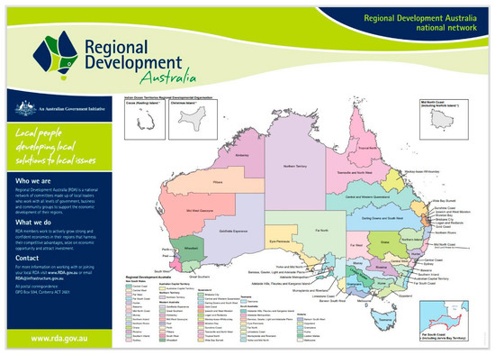
Figure 6.
Multiple Regional Development Board localities across Australia. Image by permission of Regional Development Australia. Small text can be read when enlarged. Source [38].
Some RDAs receive assistance from state governments, but this is not common. Due to the higher-priority development and support needs of such communities, geotourism has not been seen as a significant contributor and so has had only occasional RDA attention without actively being advanced. This is illustrated by the disparity between annual Australian resources sector income, which is six times greater than all Australian annual tourism income [39], of which geotourism is only a small proportion. Only in certain areas are RDAs able to assist with limited funding, and a recent approach by some geotourism representatives for financial assistance to promote a section of the Kanawinka Volcanic Trail was unsuccessful. Geotourism needs to demonstrate likely successful strategies and capacity to deliver returns to regional communities before it can expect support compared to other important community requirements. Geotrails and GeoRegions, when prepared and presented well, may receive future acceptance and success.
4.2. SEGRA
Sustainable Economic Growth for Regional Australia (SEGRA) is a semi-voluntary organisation that originated two decades ago in the large regional centre of Geelong in western Victoria. It is specifically focused on assisting country regions across Australia with innovative ideas to ‘help in providing strategic and targeted responses to the social, economic and environmental issues affecting regional Australia’. Their approach ‘aims to assist regional, rural and remote Australia to source and identify the techniques, skills and issues they need to address which will help achieve successful economic growth and development’ [40].
SEGRA holds annual conferences in different strategic regional centres across Australia each year. Over the last decade, geotourism has been introduced at their conferences as another new strategy to contribute to regional development by utilising the natural heritage of rural areas. Geotourism papers and presentations have been given in all states at SEGRA conferences in Alice Springs, Bathurst, Esperance, Port Augusta, Mackay, Baroota, Kalgoorlie and Tasmania. Conferences and geotourism seminars have been well attended and raise the profile of geotourism in provincial centres by drawing attention to their local geological and landscape assets and explaining their stories and tourism attributes. However, SEGRA’s interest in geotourism has recently been waning, most likely for similar reasons to the RDAs, demonstrating that geotourism will need to present deliverable results to warrant rural financial support.
4.3. Private Landscape Initiatives
Landscapes funded by private investment can also be partly grant-funded and/or supported by philanthropy. Two South Australian (semi-arid) examples are the Arkaroola Sanctuary in the northern Flinders Ranges (Figure 7), which is a legacy of eminent South Australian geologist Reg Sprigg [41], and the South Australian Nature Foundation’s large semi-arid zone properties of Witchelina and Hiltaba [42]. In the northern territory, an example is the Indigenous community-owned Standley Chasm, an interpretive nature tourism operation (Figure 8) providing conservation, education, interpretation and local Indigenous employment training and opportunities [43]. All of these examples are utilising geotourism in different forms—quality accommodation and exploration trips, four-wheel drive tours and camping. Landscape walks with A–B–C components are provided by local Indigenous guides with their interpretation and legends/stories of ‘Country’, which is the Australian Indigenous term for landscapes.
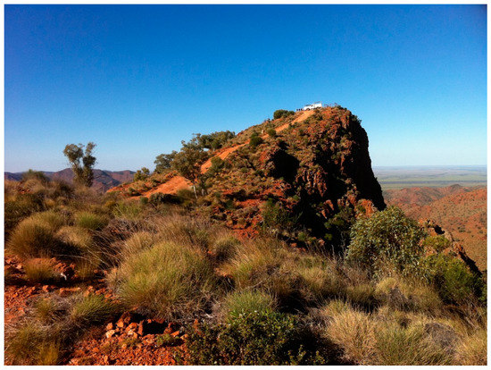
Figure 7.
Spectacular Ridgetop country, Arkaroola Wilderness Sanctuary (a private enterprise), Flinders Ranges, South Australia. Image by permission of James Newcombe. © James Newcombe 2012.
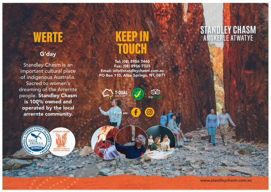
Figure 8.
Standley Chasm Indigenous Geotrail Brochure cover, Northern Territory [43]. Image by permission of the Standley Chasm management.
5. Australian Geotourism Learnings Derived from Kanawinka Geopark, ANLs and ‘Protection vs. Promotion’ Issues
5.1. Learnings from the Geopark
Learnings from Kanawinka and the ANLs can be grouped under several main themes:
Government and local support
- Political support needed from state and national governments and agencies;
- Geotourism is best connected to regional development organisations;
- Local leadership, not centralised management, is more effective for geotourism undertakings;
- Government engagement with private landscapes needs to be more flexible and cooperative.
Strategic positive promotion
- Promotions must elevate understanding of geotourism’s raison d’etre;
- Strategies are required to effectively coordinate and promote large georegions;
- Convincing the resource and agricultural sectors that geoparks are not restrictive;
- Convincing the national parks and conservation industries that geoparks are not competition.
Increasing the levels of visitor experience
- Interaction with neighbouring geotourism attractions where available;
- Provision of international-level quality facilities and interpretation;
- The value of using more digital technologies for interpretation.
Wider inclusive engagement
- The importance of A–B–Cs in all approaches to geotourism (i.e., ‘Geodiversity’);
- Diversity and inclusion are necessary; Indigenous involvement, in particular;
- Increased use of general terms: e.g., ‘Landscape stories’ rather than ‘Geology’;
- Dedicated enthusiasm and effort cannot succeed without committed funding.
5.2. Other Geotourism Issues of the Decade
5.2.1. ‘Protection vs. Promotion’: The Heritage Dilemma
While geotourism learned a number of important outcomes from the Kanawinka and ANL experiences, there were other realisations emerging through the last decade. Several of these principally arose from the ‘Protection vs. Promotion’ issues relating to sites of vulnerability, including geoheritage sites. Reconstruction across Europe following the widespread destruction of World War Two drove an initial focus on rebuilding and repairing ‘Built Heritage’ in so many ruined cities and towns [44]. Since then, the concept of heritage and conserving places of significance has burgeoned and extended to ‘Natural Heritage’ sites. The subsequent expansion of world-wide tourism and visitation to heritage sites has placed many such sites under increasing pressure. This is now identified as ‘over-visitation’ in Europe, Asia and the Americas and raises the continuing dilemma of protecting these important sites while attempting to cater to the economic benefits they bring to any affected locality. Pressure is greatly felt by national parks (and their equivalents), ecologists, tourism developers, promoters and the local communities. These concerns apply equally to geotourism as the latest participant in this field.
5.2.2. Bio- and Ecofocuses: Unawareness or a Bias against Geology?
The Australian continent has >9000 various protected/ecological/wilderness areas, of which >500 are national parks (NPs) [24]. Dominance by national parks and various ecological bodies has been reflected in the management of their sites. Throughout the 20th century, their focus had been on conservation and biology: ‘Australia’s national parks and reserves used to be managed as conservation enclaves’ [25] [Supplementary S2]. Similarly the emerging ecological movements were concentrated on the bioenvironment and water. Water was by now considered as an environmental element, not just a liquid mineral resource as previously. Even in some quarters, water was becoming regarded more as a ’living’ entity. Such activism was ‘humanising’ elements of the environment (e.g., the ‘Gaia’ concept), which appealed to increasing numbers of the public. NPs were ambivalent at best about visitation, facing the dilemma of conserving but needing increased income, impelled by State ‘user pays’ directives and ‘Nature Tourism’ programs in all states. Ecologists became concerned that Ecotourism projects and glamping schemes may be damaging the environments and wildlife they are reliant upon promoting. Similar concerns began to develop for geotourism regarding geoheritage sites.
5.2.3. Tourism, National Parks and Geologists—Reluctance, Resistance, Reticence?
The Tourism industry strongly promotes landscapes but does not attempt to explain or interpret them. As mentioned earlier, NPs were also concerned at these alternative landscape concepts of geoparks (as perceived funding competitors) and ANLs (as requiring reluctant partners). NP staff and ecologists have minimal or no geological or earth science components in their degrees, certifications or training. ‘Few parks services employ or work with geologists or earth scientists and management and interpretation is strongly biased towards biological and ecological aspects…Some of those with the least appreciation of geological sites are biological scientists’ [9]. Earth Sciences themselves suffer from perception problems; NPs and the environmental movement criticize geologists, miners and mining on the grounds that they run extractive and ’exploitative’ industries, cause environmental ‘damage’ and contribute directly to ‘Climate Change’. These are claims with some factual components but are regularly reported in the media with emotive emphasis. Oil, uranium and now ‘carbon’ are depicted as threatening minerals and elements. Geology itself is misunderstood as Depth and Deep Time are both difficult concepts for most people, leading to disinterest or avoidance. The terminology of geology is too specialised for the public. Of relevance to this issue is the widely held perception in education and tourism fields that the average educational level of adults and parents is in the year 7, 8, or 9 (mid-secondary school) range. As such, geological communication to the adult public is best re-oriented to this level without an academic or professional prejudice. Geotourism struggles from the same perceptions by direct association.
5.3. Learnings from These Issues
Publicly, unfortunately, the work of geoscientists, geologists, engineers and indeed scientists in general is increasingly challenged. The factual scientific argument that minerals support all the framework of modern life is struggling against the media, social media and activism which are ‘humanistic’ or ‘anthropomorphic’. These agencies present the planet and water as living entities. So, together with the scientific arguments, geology and geotourism have to engage new approaches to relate to the media, the public, national parks, ecologists and the tourism industry. ‘Engagement with the cultural landscape is not ‘dumbing down’ the geology’ [45]. This means delivering messages that link the inanimate with the animate:
- Educate the concept that the soils, ecology, vegetation and any life forms are the direct derivative of the underlying rock, minerals and water;
- Use the catchphrase ‘Soil, environment and culture come from geology and climate.’
- Geoheritage is as important as ‘natural (bio) and built (cultural)’ heritage;
- Rehabilitation of extracted landscapes contributes towards sustainability;
- Emphasise a wider A–B–C approach in geology and geotourism. This can also be enhanced by introducing the term ‘Geodiversity’ to the public;
- Use natural ‘landscape stories’ to explain the beauty, spectacle and significance of geosites;
- Use cultural ‘landscape stories’ to describe human and spiritual interpretations and interactions with geosites;
- Water has increasing threats in terms of its storage, containment, quality and scarcity. Use ‘Water’ as a link between geology and life (through hydrology and hydrogeology);
- Lobby for basic geology with a human framework into eco- and NP training and schools;
- Use language and terminology for the general public at mid-secondary school level.
Various geotourism-based organisations began to address these experiences to enable the different aspects of (Australian) geotourism to evolve. As the decade since Kanawinka, NP attitudes and ANLs has progressed, geotourism has delivered some successes and made necessary improvements to its strategies based on the above learnings. Discussion of these efforts follow.
6. The GSA, AGN and AGC: Towards a National Geotourism Strategy
6.1. The Geological Society of Australia (GSA)
The Geological Society of Australia (GSA) has divisions in every state with various subcommittees focusing on geological heritage, field guides and geotourism. The emphases on each vary across the divisions. The GSA has for half a century promoted nominations, listings and descriptions of sites of geological significance (now termed ‘Geoheritage Sites’) with the intention of protecting them [46]. In several States this has been achieved by elevating some of these sites onto state heritage or national heritage registers and in so doing, obliging land developers to notify and consult with the relevant authorities regarding any potential impact on the geoheritage feature. The GSA is an important member of the Australian Geoscience Council. The GSA has developed geological guide booklets and pamphlets in all states [47] and made many of them freely available via the GSA website. Around the nation, the GSA has been initiating geotrails, usually in conjunction with local authorities and occasionally with support from state geological agencies. Generally, these are short geotrails as they are easier to design, plan, manage, and maintain, and require the support of a single local council or shire with an interest in them [48,49]. Several longer geotrails cross various jurisdictions and borders and involve broader coordination.
Notably for geotourism, within a three-year period, 2016–2018, three major national conferences involving the GSA membership were held in Adelaide, South Australia’s capital city: the Australian Earth Sciences Convention (2016), the Global Eco Asia-Pacific Tourism Conference (2017), and the Australian Geoscience Council Convention (2018). GSA-based forums, workshops and seminars were presented on geotourism themes at all three, including reviewing past experiences with Kanawinka and the ANL’s and an expanding role for geoheritage. From these discussions, several distinct approaches were given major impetus: reviving Geopark attempts by the Australian Geoparks Network (AGN), instigating a new concept of GeoRegions by the Australian Geoscience Council (AGC) and the development of a national series of new Geotrails by the GSA, all directed at elevating the public profile of geotourism in Australia. A resolve was also made to boost virtual experiences of landscapes with innovative approaches, recent examples being South Australia’s Flinders Ranges and Hallett Cove geological areas [50].
6.2. The Australian Geoparks Network (AGN) and Geopark Initiatives
The Australian Geoparks Network (AGN) supported Kanawinka Geopark during its four-year existence in 2008–2012. It continued to lobby for Kanawinka’s re-registration and continuation in the aftermath of the Australian Government’s instruction against renewal of Kanawinka’s UNESCO status. In recent years the AGN has been reactivated and is working strongly, particularly in Western Australia, with preparations for up to four ‘pre-aspiring’ geoparks in the more populated southwestern regions of that state [51]. Two pre-aspiring geopark initiatives in the continent’s east (Queensland and New South Wales) undertaken by other groups independent of the AGN have been unsuccessful due to difficulties with some elements of local support. A current proposal for the Ku-Ring-Gai Peninsula just north of Sydney as a future geopark has considerable support, particularly aided by its fruitful involvement with local Indigenous groups and embracing full A–B–C components in their plans [52,53]. In South Australia a large loop geotrail (~400 km) proposed for the Flinders Ranges encloses many individual geoheritage sites nominated collectively for World Heritage listing [7]. This loop may also define the region and its assets as a suitable boundary for a geopark as they can coexist with World Heritage areas. In Australia, large- or small-loop geotrails may be a strategic tactic to precede future geopark plans. Geotourism in Australia does not depend on geoparks but would be significantly boosted with their return.
6.3. The Australian Geoscience Council (AGC) …
The Australian Geoscience Council Inc (AGC) consists of geoscientific organisations operating across the broad field of Australia’s extractive, mineral and environmental industries, including government bodies and academic research institutions. The AGC’s primary objectives are threefold [54]:
- To provide expert apolitical advice to governments on geoscience matters;
- To promote effective geoscience education and research;
- To promote a greater appreciation of the economic, environmental and cultural values of the geosciences to the Australian public.
The preference of governments in Australia is to view anything with a ‘Geo’ prefix through the lens of mining activities and to delegate such decision-making to their Departments of Energy, Mining, Geological Surveys and the like. Unfortunately, this approach also extends to geotourism, geoparks and GeoRegions rather than (perhaps better) directing them to tourism agencies. However, the AGC recognises and prioritises the importance of gaining government endorsement. It is devising a National Geotourism Strategy that can fulfil the expectations of both the resource and tourism fields and is acceptable to the evolving policies at the government level in all states and the Australian Government. To help achieve this, the AGC is able to draw upon the expertise of its member organisations, many members of whom work or have close connections with government.
6.4. … and the National Geotourism Strategy
Thus, the AGC set up the National Geotourism Strategy (NGS) in 2021. Aware that governments are concerned with returns on investment for provisions of finance or resources, the strategy is aimed to demonstrate that geotourism can contribute to the economic benefit of the community by its capacity to:
- improve visitor experience at natural sites and geoheritage sites;
- ensure responsible and sustainable practices to protect and promote site visitation;
- include the A–B–C elements in geotourism to broaden its public appeal;
- increase and improve community engagement;
- protect cultural sensitivity of some geoheritage and geosites, where appropriate.
The NGS receives significant input from seven working groups, consisting of specialists from the AGC member organisations, with each group concentrating on a particular goal [55]:
- Goal 1:
- Assess, utilise and promote new digital technologies;
- Goal 2:
- Define approval pathways for major geotourism projects;
- Goal 3:
- Establish a framework for creating high-quality sustainable geotrails: local, regional, and national;
- Goal 4:
- Establish national criteria for geoheritage listings suitable for geotourism;
- Goal 5:
- Develop geotourism in regional mining communities with potential geoheritage and cultural heritage sites;
- Goal 6:
- Strengthen Australia’s international geoscience standing through geotourism excellence;
- Goal 7:
- Develop and enhance interpretation/communication skills for presenters at geosites.
An excellent archive of many geotourism contributions which have informed this strategy, is located at: https://www.leisuresolutions.com.au/geotourism-industry-groups/ (accessed on 26 January 2023). Throughout 2022, work on Goals 1–5 has resulted in several virtual technologies being trialled, with the AGC maintaining close consultation with Geoscience Australia (the leading national agency), geotrails in several states approaching commencement, preparation of a Geoheritage Criteria Register, and the reappraisal of historical mine sites in Tasmania and South Australia for their geotourism capacity. For Goals 6 and 7, geotourism is now positioned for inclusion within Geoscience Education at a forthcoming international conference, and geological communication skills are being reviewed in detail to improve public understanding and appreciation of geoheritage sites. These seven goals are evidence that the NGS is systematically addressing the learnings gathered over the last decade from the varied geotourism experiences across the continent.
7. GeoRegions, Geotrails and Geoheritage Trails
7.1. A new Australian Landscape Model
UNESCO now has 195 geoparks across five continents of the world, while the Australian continent had one briefly and now has none. For a large continent with a great many significant landscape areas containing special and unique geological attractions suitable for geoparks, this has been a squandered international opportunity. The GSA, AGN and AGC note with interest the recent early geopark successes in Canada, a large-area nation with powerful provincial governments, similar to the Australian states, and which now has five small geoparks [56]. In Australia, contemplation of the geopark model has led to consideration of instigating other geotourism landscape hubs of an Australian character, which could reflect important elements of the geopark model against a potential revival of geoparks in future years, yet for the present would avoid the political pressures experienced during the Kanawinka de-listing which still linger. The collective insights of the GSA, AGN and AGC over the last decade are derived from the Kanawinka experience, reflections on national parks and ecology responses, motivations of the ANL’s and linkages with the RDA and SEGRA. These have coalesced into the newer outcomes of GeoRegions, geotrails and geoheritage trails, all major contributors to Australian geotourism.
7.2. GeoRegions
7.2.1. The GeoRegion Concept
The GSA, AGN and AGC have contributed to developing the concept of Australian ‘GeoRegions’ to promote landscape-scale geotourism and encourage the commitment of resources to them [17,18]. AGC Goal 5 encourages inclusion within a GeoRegion of the biotic (‘B’) and cultural heritage content (‘C’), embracing mining heritage. GeoRegions are a uniquely Australian concept designed to be acceptable and understandable to the public, government and management authorities and be compatible with this nation’s culture. The term ‘GeoRegions’ is intended to be a marketable brand for tourism and acceptable to governments. The GeoRegion concept has arisen as a multiple strategy to:
- reawaken and utilise the earlier ANL concepts;
- identify regions that contain a series of significant geosites;
- introduce the concept of ‘GeoRegions’ to Australian audiences;
- be a concept which local populations and authorities can recognise and with which thay can identify and relate;
- be a concept in which local audiences want to participate to promote/boost their tourism;
- be marketable in their own right;
- be a preparation for reactivating the geopark initiative across Australia.
The GeoRegion strategy aims for support from state governments and national geoscience-based organisations to acquire the backing that was not sought for Kanawinka prior to 2008 or provided to it subsequently. A–B–C categories can be integrated into suitable GeoRegion packages for local tourism promotion agencies and local councils who are involved with any associated funding. This A–B–C approach prepares the GeoRegion for the attributes of an aspiring geopark if that path is subsequently pursued. UNESCO has a strategy of developing more geoparks world-wide [39] but as they do not have federal or state government support in Australia, GeoRegions are a necessary evolution of geotourism for this nation.
7.2.2. The Murchison GeoRegion: An Example of Semi-Arid Geotourism
Australia’s first GeoRegion is in Western Australia. This is the Murchison GeoRegion. This is located just inland of the central-northern Western Australian coastline, abutting the Shark Bay World Heritage area and former ANL. It has the brand theme ‘Ancient Lands, Brilliant Skies’ (Figure 9) [8]. The Murchison River is the second-longest in the state (~800 km) and drains the inland Archaean Yilgarn Craton westwards to the coast, receiving much of its water from summer cyclones. The GeoRegion features 21 geo-, bio- and cultural heritage sites (A–B–C) across a 400 × 400 km area, with access to the sites on a ‘GeoDrive’ trail. Sites vary from Mount Magnet’s early mining heritage to desert landforms, meteorite craters, dryland botany, waterholes and ephemeral lakes.
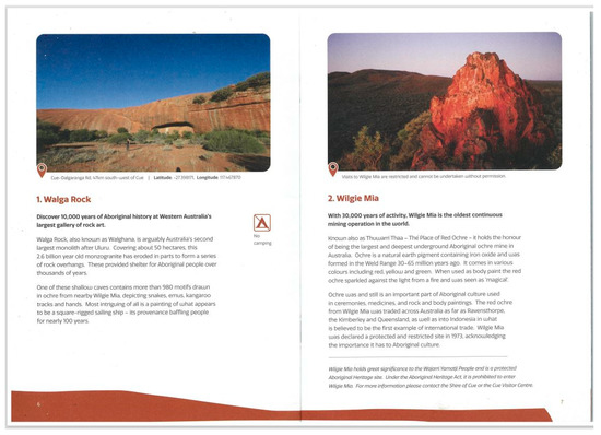
Figure 9.
Two pages of the Murchison GeoRegion Guidebook featuring strong relationships between geology and Indigenous Culture. Image by permission of Murchison GeoRegion Administration. Source [8].
It highlights the abiotic, biotic and cultural features of significant sites in the region to encourage a deeper understanding of, and connection with, the land…While visiting the 21 sites along the GeoRegion Trail, we encourage you to take a moment to consider how each element works together’ [8].
It has produced an informative guidebook as an app which received national ABC TV coverage at its launch. The Murchison GeoRegion has the characteristics and aims similar to those of a geopark. In particular, Murchison also has in common the ancient Australian landscapes of the Yilgarn and Gawler Cratons, and the Curnamona, Musgrave and Aileron Provinces of WA, SA and NT. These show the essence of semi-arid ‘Outback’ Australia. Most importantly, it has the solid support, pride and commitment of its communities and leads the way for creating other Australian GeoRegions.
7.2.3. Other Potential GeoRegions
South Australia provides three contrasting examples of potential GeoRegions. These are a large coastal island, a volcanic plain and an arid mountain range. Kangaroo Island is a former ANL (Figure 5) 150 km × 50 km in area with a Cambrian basement intruded by granites and overlain by Devonian sediments with outstanding fish fossils, Palaeogene–Neogene ironstone plateaux and Quaternary Ice Age dunefields. The Geological Survey of South Australia has produced a detailed geology map of the complete island highlighting the variety of 18 geosites revealed along its coastline and is an excellent interpretation aide [57]. Island flora and fauna species evolved in isolation and fossils are found. Recent bushfires devastated one third of the island, but the bioscape is now evidence of resilience and the excellent restorative work re-establishing floral and faunal habitats. Its human history contains the tragedy of a disappeared Indigenous population cut off from the mainland by the last marine post-glacial transgression and who died out ~2000 years before the arrival of European explorers, whalers and settlers [58]. All the elements of a GeoRegion are present in abundance.
In the southeast of the State, the Kanawinka Volcanic Plain retains all the elements that made it a successful geopark for four years and is thus eminently suitable as a GeoRegion. A visual proposal for this has recently been released, illustrating its major landscape attractions and extending it to include the Grampians sandstone ranges [59]. The semi-arid Flinders Ranges (also a former ANL) is being nominated for World Heritage and a lengthy-loop geotrail has been proposed to link its 35 geoheritage sites with bio- and cultural heritage localities [7]. The looped geotrail can define a GeoRegion with all the suitable elements. All three potential GeoRegions have outstanding geotourism components and could evolve to become geoparks in the future.
7.3. Geotrails
In 2012, the year that UNESCO was required under Australian Government instructions to deregister Kanawinka Geopark, Australia had relatively few geotrails. Globally, a trend was emerging for longer networks of geotrails, such as the Canadian model. This is a series of province-based medium- and short-length geotrails that link across the North American continent with easy access along its full extent [60]. Realising that a long geotrail network concept was more appealing to the local authorities and councils rather than the unfortunately politically-charged brand name ‘Geopark’ at that time, the Kanawinka Director converted Kanawinka Geopark to ‘Kanawinka Geotrails’ where the focus became the multiple network of roads linking ~400 volcanic and karst sites and the Budj Bim and Naracoorte Caves World Heritage sites across the large Kanawinka region (see detailed Kanawinka Map Brochure [Supplementary S1]. Kanawinka Geotrails has been successful ever since and will continue to be with the added advantage of retaining local support and the name ‘Kanawinka’, should it be reactivated as a geopark in the future. The geotrail concept and movement in Australia has blossomed in the last decade (see below), to which Kanawinka has therefore made a significant contribution.
Some ‘Geoheritage Trails’ already existed in South Australia, arising from the GSA (SA) Division’s Geoguide series based around designated South Australian geoheritage sites (formerly listed as ‘Geological Monuments’): Brachina Geotrail (a 20 km transect through the Flinders Ranges with multiple geoheritage sites), Hallett Cove Geotrail (an urban geological park dramatically demonstrating Precambrian platforms, Permian glacial action and Palaeogene/Neogene estuarine deposition along a linear walking trail) and North Terrace Building Stones Geotrail (describing the geoheritage of the State’s Parliamentary, Institutional and University edifices and their stones’ origins from rural quarry sites) [61]. Other states also contain examples of short, medium and long geotrails—the Ulladulla coastal Geotrail in New South Wales, the ‘Cradle Coast’ Geotrail to assist rurally depressed northwest Tasmania and the ‘Dig the Tropic’ Geotrail traversing the entire state of Queensland from east to west for 1200 km [62].
However, the reality was that many ‘Geological Monuments’, GSA and Geological Survey Field Guides and interpretive field maps were near-dormant assets, being largely unknown or inaccessible to the general public. Some geologists felt that this anonymity aided in the protection of geoheritage sites, while others suggested that increased awareness might achieve the same. At several subsequent conferences over the last decade, discussions in geotourism seminars motivated an enthusiasm for more geotrails to be developed and publicised nationally, as their advantages and suitability for a large continent were more widely realised:
Geotrails are relatively easy to establish as they can be constructed around routes currently used by tourists—4WD, car, bike, walking and horse-riding trails—easily linking with accommodation destinations but not competing with or impacting on land management/access issues [60].
Geotrails have been an emerging 21st-century trend linking serial geosites, natural and mining and cultural features, effectively linking geo-themes on a wide scale [63].
There is not a common format for geotrails across Australia and each state or local council has its own variations and forms of interpretation signage. Standardised formats, signage and apps, etc. may be a goal for the AGC under its NGS or through the GSA. While some attempts have been made in Europe to commence such commonality, it may be seen as desirable to experience local variations.
In 2023, Australia has many geotrails with more under development [64]. Most are short or of moderate length, but the Dig the Tropic Geotrail across Queensland and the Savannah Way across Australia’s tropical north from Queensland to Western Australia, supported by local Councils and Shires along their routes, are outstanding Australian examples of the Canadian cross-continental model. Short geotrails have appeal for single local councils and shires as they can be funded and managed by the one authority. They are now appearing in all states: abandoned Railway Cutting Geotrails in Queensland and WA, short coastal walking geotrails in Port Macquarie and Newcastle (NSW) and Port Victoria (SA), a Dinosaur Trail (Victoria), and in the Northern Territory are found the Darwin City, Pine Creek and Red Centre Standley Chasm short geotrails. In Western Australia, the concept of GeoDrive Trails is being introduced along stretches of populated coastlines (Alan Briggs pers comm 2022) after being successfully trialled and accepted across the ‘Ancient Lands, Brilliant Skies’ country of the Murchison GeoRegion’s GeoDrive trail, increasing the driving public’s exposure to geotourism along the various routes.
8. A New Australian Geotourism Innovation: Integrating a Geotrail with an ICOMOS Cultural Route
8.1. Geotourism Linking with ICOMOS
All these learnings and experiences have brought geotourism in Australia to 2023. With Australian geotourism now focused on broadening its appeal to the public based on a decade of varied experiences, it is appropriate to look more widely and in unexpected places for ideas, innovations, opportunities, areas of support and unrecognised resources to expand its attractions. Another new direction that Australian geotourism can consider now presents itself by combining with a globally significant ICOMOS Cultural Route.
ICOMOS (the International Council on Monuments and Sites) is an official advisory body to UNESCO, evaluating cultural sites and routes that link human endeavour with landscapes [44]. Two toolkits are available to identify such sites and assess their suitability or vulnerability for public exposure or otherwise: the Australia ICOMOS Heritage Toolkit (now also utilised internationally) and the National Geoheritage Toolkit [65]. ICOMOS identifies regions and linear entities of great cultural significance within many nations, some of which also cross borders. Examples are: the Silk Road, Rock Art localities in northern Africa, Japanese pilgrim routes and Kalgoorlie’s Golden Pipeline [66,67]. These are known as ICOMOS Cultural Landscapes and Routes, a resource previously unknown to Australian geotourism. Critically, such trails are shaped by the geology of their settings.
8.2. The Overland Telegraph Line: Geology Defines a Great ICOMOS Cultural Trail
ICOMOS Australia has designated an Australian Cultural Route that is highly compatible with geotourism and known as the Overland Telegraph Line Cultural Route (OTL). It can also be a long geotrail concept, taking advantage of Australia’s wide diverse interior with its red desert rocks so frequently promoted in tourism advertising. The story of this route is very well documented [68]. The OTL Cultural Route links South Australia to Darwin in the Northern Territory (‘from the top to the tail’ in Tourism jargon) (Figure 10). With a single continuous copper wire completed in 1872, the line itself was highly significant in the development of the Australian nation, finally linking it telegraphically to the continents of Asia, Europe and North America, and to the centre of the British Empire in London (Figure 11). It bypassed connections by sailing ship, which took more than three months from Britain to Australia. After initial exploration, the OTL was constructed by two colonial work teams with the vital assistance of Aboriginals and Afghan cameleers (Figure 12) [69].
Figure 10.
A 1940 historical map of the Overland Telegraph Line Route. © South Australian Library and reproduced with their permission. Source [70].
Figure 11.
Historical photo from 1935: OTL constructed in 1872; rail line to Alice Springs built 1910. © History SA and reproduced with their permission. Source [71].
Figure 12.
Afghan Cameleers provided the majority of transport for goods, material and equipment required for the construction of the Overland Telegraph Line. The camels obtained water from the artesian springs, which dictated the transport and OTL route. © History SA and reproduced with their permission. Source [69].
For 2000 km, the OTL followed the geology between the two great Delamerian and Petermann Orogenies through the middle of the Australian continent from south to north [72]. This is a great ‘Outback’ corridor from the Flinders Ranges past opal fields and vast inland seas of huge dry salt lakes, following a line of desert springs along the western edge of the Great Artesian Basin (shown to the explorers by Aborigines) (Figure 13) to the Red Centre’s Macdonnell Ranges (Figure 14) and finally into the tropical lowlands of the north.
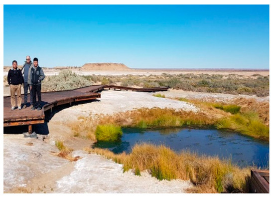
Figure 13.
Great Artesian Basin ‘Mound’ Spring in desert country, northern South Australia. Image by permission of SA Department for Environment and Water.
Figure 14.
Macdonnell Ranges (Petermann Orogeny), Central Australia, Northern Territory. Image by permission Emu Run Experience. Source [73].
This iconic route symbolises both a joining of cultures linking the Australian Colonies to the world of nations and a clash of cultures as European technology, construction and land acquisition moved inexorably through lands occupied by Indigenous peoples for millennia. In Australia, there is a current reassessment of the social impacts and legacy of its construction and operation upon the Indigenous peoples living along its hinterland as part of a national reconciliation policy. This is consistent with the newly introduced socio-political element being considered within geotourism (Figure 15) [6]. Recently the OTL celebrated the 150th anniversary of its ceremonial connection in 1872 near Alice Springs, and a commemorative history book has been released [68].
Figure 15.
Granite boulder memorial to Reverend John Flynn, originator of the Royal Flying Doctor Service, which services the vast distances of inland Australia. Memorial located at the Heavitree Range, Alice Springs. The citation refers to a challenge between Geoheritage and Geoculture. Subsequently, after much conflict, this boulder, locally known as a ‘marble’, has been returned to the others at the sacred site of the ’Devils Marbles’. Photo: Nicholas Hall. © Nicholas Hall. Source [74].
Within some of these landscapes are relict ecology (cycad ‘Palms’ and baobab trees), megafaunal fossils, and desert flora and fauna (Figure 16 and Figure 17). In Geomythology, which is a conjunction of geology and landscape stories, both of the mountain ranges and the vast dry lakes were formed by giant snake ancestors in the Dreamtime world of the Arrernte and Adnyamathanha people. The OTL trail has many layers, of which the geology and hydrogeology are the powerful drivers of all subsequent biological and cultural events, evoking the A–B–C of geotourism addressed throughout this paper.
Figure 16.
Cycads are not palm trees and are of ancient lineage. Australia’s separation from Antarctica and drying climate resulted in isolation of the central Australian species Macrozamia macdonnellii, existing only in the central Australian Macdonnell Ranges, where shade and water are found. Its nearest relatives are located 1400 km away. Photo: I Lewis. Image reproduced with the permission of the author.
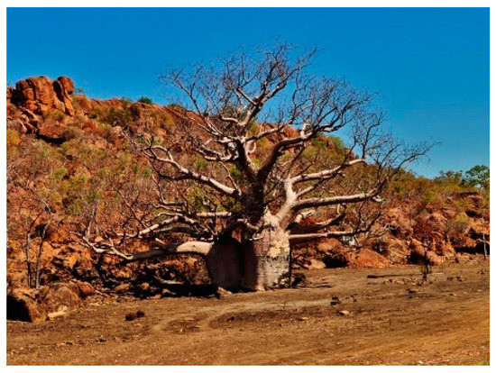
Figure 17.
Boab Tree (Adansonia gregorii), also known as ‘Bottle Trees’, Timber Creek, Northern Territory. Photo: Pufus&ViniusFollow and reproduced with their permission. Source [75].
8.3. A cross-Continental ‘Firestone Geotrail’
As a geotrail and cultural trail, the OTL can be a driving, aerial, train or coachline travel experience with some walking trail elements. It is serviced by ‘The Ghan’, a cross-continental rail experience named after the early cameleers and by a sealed highway known as the ‘Explorers Way’. Here are all the ingredients for a cross-continental geotrail with international messages derived directly from the application of the A–B–Cs and a socio-political context in equal measure—the terrain, the desert ecology, tropic life forms and the major cultural impacts. Given all this, it is ironic that Tourism Australia markets a ‘Darwin to Barossa (South Australia)’ self-drive tour as ’14 days of nature, wine and aboriginal cultures’ [76] yet does not mention the OTL or geological stories. Its reference to these is ‘striking Landscapes from wetlands to deserts, unforgettable natural wonders, from rugged gorges and salt lakes to iconic Uluru’. It then lists standout landforms, such as Kakadu for waterfalls and rock art, Nimiluk for the Katherine Gorge boat trip, Uluru, Kata Juta (the Olgas Range), Coober Pedy and Wilpena Pound in the Flinders Ranges. Based primarily on some of Australia’s most outstanding geoheritage sites, this is Geotourism but without its name, recognition or explanations of the landscapes.
The OTL intersects the Red Centre Geotrail region, abuts the Standley Chasm and Larapinta (West Macdonnells) Trails, and meets the Tenant Creek and Pine Creek Mine Trails, culminating at the Darwin City Geotrail. Northern Territory geologist Mark Azendorf has suggested the excellent name of ‘Firestone Geotrail’ for such a great central Australian concept, symbolising the geology and hot climate of central Australia (Azendorf pers comm). For geotourism, this presents the opportunity to combine with the ICOMOS international stature in a Geotrail to show the world, boosting the ICOMOS cultural stories with those of the underlying geology, which enabled the OTL to be conceived, laid out and completed. Such a combination is highly compatible with the following statement:
… the emerging concept of ‘Geoarchive’ refers to the notion that Earth, as a story-teller, has an archive of stories related to the evolution of Earth physically, geochemically, petrogenetically and structurally, and to the origin and evolution of life. The story of the development of the human race is also embedded within the archive of the Earth, with the landscape providing communities with a sense of place and the material resources to develop as a society [77].
The ICOMOS OTL Cultural Route in concert with a ‘Firestone’ Geoheritage Trail offers stimulating innovative strategies to retain and attract people to these areas. This represents another step in the evolution of geotourism in Australia, which needs to continue to be inventive in order to be relevant and encourage public attention.
9. Conclusions
Australian Geotourism has been evolving over the last decade and a half, drawing from the experiences of Kanawinka Global Geopark, the Australian National Landscapes, concerns from National Parks and the environmental movement, and of geology’s communication with the public. In response to these, two national organisations are, respectively, improving publicity for geotourism/geoparks and developing a National Geotourism Strategy recognised at the highest levels of Government, essential for any international aspirations. Both have a common aim of elevating geotourism to a mainstream activity well suited to Australia and its natural landscapes, particularly using a multifocus A–B–C approach. This strategy has the capacity to generate wider community interest, engagement and appreciation, and an increased participation in the Earth Sciences. It is beyond the role of National Parks and may have the outcome of reactivating the geopark movement and acceptability by Australian governments, to allow this nation to re-join the other five geopark continents. Australian geotourism and the public both benefit from the inclusion of the A–B–Cs in the interpretation and explanation of landscapes. In a further evolutionary step, an innovative combination with ICOMOS Cultural Routes can also be of benefit to both movements. A suggested example is the Overland Telegraph Line as an outstanding cross-continental geocultural trail.
Supplementary Materials
The following supporting information can be downloaded at: https://www.mdpi.com/article/10.3390/land12061190/s1. Supplementary S1: the detailed Kanawinka Map Brochure and Supplementary S2: Supples 2014 Reference.
Funding
No funding was provided or requested for this study or the compilation of the paper.
Data Availability Statement
Data where used has been cited from the relevant reference.
Acknowledgments
I sincerely thank the reviewers for their valuable comments that have improved this manuscript. I am grateful to my fellow members of the Geological Society of Australia, the Australian Geopark Network, and Working Groups of the Australian Geoscience Council for their productive and stimulating meetings, discussions and ideas over the last decade, contributing to the evolution of geotourism in Australia.
Conflicts of Interest
No potential conflicts of interest was reported by the author.
Disclaimer
The research and discussions contributing to this paper are derived from the author’s involvement with the Geological Society of Australia, the Australian Geopark Network and Working Groups of the Australian Geoscience Council. The author is based in South Australia and has used examples from that state as flagbearers for similar concepts in other states of Australia.
References
- Dowling, R.K.; Newsome, D. (Eds.) Geotourism; Elsevier—Butterworth-Heinemann: Oxford, UK, 2005. [Google Scholar] [CrossRef]
- Dowling, R.K., Newsome, D., Eds.; Geotourism. In Proceedings of the Inaugural Global Geotourism Conference, ‘Discover the Earth Beneath Our Feet’; Promaco Conventions, Perth, Australia, 17–20 August 2008. [Google Scholar]
- Ollier, C. Problems of geotourism and geodiversity. Quaest. Geogr. 2012, 31, 57–61. [Google Scholar] [CrossRef]
- Chen, A.; Lu, Y.; Ng, Y.C. The Principles of Geotourism; Science Press [Springer]: Beijing, China, 2015. [Google Scholar] [CrossRef]
- National Geographic Website. Retrieved 9 June 2020. Available online: https://www.nationalgeographic.com/maps/geotourism/ (accessed on 26 January 2023).
- Newsome, D.; Ladd, P. The dimensions of geotourism with a spotlight on geodiversity in a subdued landscape. Int. J. Geoheritage Park. 2022, 10, 351–366. [Google Scholar] [CrossRef]
- Lewis, I.D. Linking geoheritage sites: Geotourism and a prospective Geotrail in the Flinders Ranges World Heritage Nomination area, South Australia. Aust. J. Earth Sci. 2020, 67, 1195–1210. [Google Scholar] [CrossRef]
- Murchison GeoRegion Website. Available online: www.murchisongeoregion.com (accessed on 26 January 2023).
- Creaser, P. Chapter 2 Australia’s Geological Heritage: Raising awareness at a national level. In Global Geotourism Perspectives; Dowling, R.K., Newsome, D., Eds.; Goodfellow Publishers Ltd.: Oxford, UK, 2010; pp. 18–32. [Google Scholar] [CrossRef]
- Tourism Australia Website. Available online: https://www.tourism.australia.com/content/dam/digital/corporate/documents/future-of-demand/tourism-australia-global-future-of-tourism-demand-research-public-report.pdf (accessed on 26 January 2023).
- QANTAS u-Tube Site. Available online: https://www.youtube.com/watch?v=vShHWaNy8O4 (accessed on 26 January 2023).
- UNESCO. World Heritage List. Available online: https://whc.unesco.org/en/list (accessed on 26 January 2023).
- Brocx, M. Geoheritage Values of Shark Bay, Western Australia, The Australian Geologist (TAG) 204:9-11; Geological Society of Australia: Sydney, Australia, 2022. [Google Scholar]
- Kanawinka Geopark Website. Available online: https://www.visitportland.com.au/kanawinka-geopark-coast-caves/ (accessed on 26 January 2023).
- Dowling, R.K.; Newsome, D. Chapter 1 Geotourism: A Global Activity. In Global Geotourism Perspectives; Dowling, R.K., Newsome, D., Eds.; Goodfellow: Oxford, UK, 2010; pp. 1–17. [Google Scholar] [CrossRef]
- Lewis, I.D. Chapter 14 Kanawinka Australia–setting up, marketing and ensuring the future of a large geopark. In Global Geotourism Perspectives; Dowling, R.K., Newsome, D., Eds.; Goodfellow Publishers Ltd.: Oxford, UK, 2010; pp. 1–23. [Google Scholar] [CrossRef]
- Robinson, A.M. The History of Geopark Development in Australia–A New Way forward. Geoconserv. Res. 2022, 5, 89–107. [Google Scholar] [CrossRef]
- Robinson, A.M. Geotourism, GeoRegions, Geotrails, and Geoparks–A Regional Development Opportunity for Australia, General Briefing (23 September); Australian Geoscience Council Inc.: Canberra, Australia, 2022; Available online: https://bit.ly/3yWex5u (accessed on 26 January 2023).
- Kanawinka Geotrails Website. Available online: https//.www.visitgrampians.com.au/products/kanawinka-geotrail (accessed on 26 January 2023).
- James, P. Wicked Witchelina and Hotspot Hiltaba—Is it time for another UGG boot in Australia? Field Geol. Club S. Aust. Bull. 2019, 48, 7. [Google Scholar]
- Budj Bim Website. Available online: https://www.budjbim.com.au/about-us/world-heritage/ (accessed on 26 January 2023).
- Grant, L. The Fighting Gunditjmara. Australian War Memorial Website. 2021. Available online: https://www.awm.gov.au/articles/blog/the-fighting-gunditjmara (accessed on 26 January 2023).
- UNESCO. Global Geoparks List. Available online: https://en.unesco.org/global-geoparks/list (accessed on 26 January 2023).
- Parks Australia and Tourism Australia. Australia’s National Landscapes: 2013 Outcome Report; Parks Australia, Australian Government: Canberra, Australia, 2013.
- Supples, C. Australia’s National Landscapes: A partnership between tourism and conservation—NBSAP Forum 2014. Available online: https://www.wettropics.gov.au/site/user-assets/docs/final_tor-national-landscapes_v1_august2012.pdf (accessed on 26 January 2023).
- DCCEEW Website. Department of Climate Change, Energy, the Environment and Water. Available online: http://www.environment.gov.au/topics/national-parks/national-landscapes-0 (accessed on 26 January 2023).
- Schofield, H. Australia’s National Landscapes Program—Promoting our World Heritage icons. In Keeping the Outstanding Exceptional: The Future of World Heritage in Australia; Figgis, P., Leverington, A., Mackay, R., Maclean, A., Valentine, P., Eds.; Australian Committee for IUCN: Sydney, Australia, 2013; pp. 180–185. [Google Scholar]
- Osmond, M. Unlocking Our Great Outdoors; Tourism & Transport Forum: Sydney, Australia, 2017; Available online: https://www.ttf.org.au/?s=unlocking+our+great+outdoors (accessed on 26 January 2023).
- Manifold, P. Written in Stone: Reading the Rocks of the Great Ocean Road; Philomena Manifold: Fitzroy, Australia, 2017. [Google Scholar]
- Hatherly, P.; Brown, I. The Blue Mountains—Exploring Landscapes Shaped by the Underlying Rocks, Uplift and Erosion; Windy Cliff Press: Mount Victoria, NSW, Australia, 2022. [Google Scholar]
- Whitelaw, P.A.; King, B.E.; Tolkach, D. Protected areas, conservation and tourism—Financing the sustainable dream. J. Sustain. Tour. 2014, 22, 584–603. [Google Scholar] [CrossRef]
- Tolkach, D.; King, B.; Whitelaw, P.A. Creating Australia’s National Landscapes: Issues of collaborative destination management. J. Destin. Mark. Manag. 2016, 5, 117–132. [Google Scholar] [CrossRef]
- EA Website. Available online: https://www.ecotourism.org.au/ (accessed on 26 January 2023).
- ANL Reports Website. Available online: http://www.tourism.australia.com/national-landscapes/8335.aspx (accessed on 26 January 2023).
- Mountains of Memory. Flinders Ranges Experience Development Strategy Pilot—National Long-Term Tourism Strategy; 2011. Available online: https://www.austrade.gov.au/ArticleDocuments/5499/Flinders-Ranges-Experience-Development-Strategy.pdf.aspx (accessed on 26 January 2023).
- Kinnear, S.; Charters, K.; Vitartas, P. (Eds.) Regional Advantage and innovation—Achieving Australia’s National Outcomes; Physica-Verlag, Springer: Berlin/Heidelberg, Germany, 2013; pp. 3–20. [Google Scholar]
- Briggs, A.; Newsome, D.; Dowling, R. A proposed governance model for the adoption of geoparks in Australia. Int. J. Geoheritage Park. 2021, 10, 160–172. [Google Scholar] [CrossRef]
- RDA Website. Regional Development Australia. Available online: https://www.rda.gov.au/about (accessed on 26 January 2023).
- Briggs, A.; Dowling, R.; Newsome, D. Geoparks–learnings from Australia. J. Tour. Futur. 2021; ahead-of-print. [Google Scholar] [CrossRef]
- SEGRA Website. Available online: segra.com.au (accessed on 26 January 2023).
- Irving, J. Arkaroola—Creating a new type of protected area. In Innovation for 21st Century Conservation; Figgis, P., Fitzsimons, J., Irving, J., Eds.; Australian Committee for IUCN: Sydney, Australia, 2012; pp. 86–93. Available online: https://www.researchgate.net/profile/James-Fitzsimons-3/publication/256128440_Innovation_for_21st_Century_Conservation/links/5e3758d1a6fdccd96581afc4/Innovation-for-21st-Century-Conservation.pdf#page=86 (accessed on 26 January 2023).
- James, P. Geotourism Matters #1—What is Geotourism? Naturematters 2020, 1, 12. Available online: www.naturefoundation.org.au (accessed on 26 January 2023).
- Standley Chasm Website. Available online: https://www.standleychasm.com.au/about (accessed on 26 January 2023).
- ICOMOS Mission Website. Available online: https://www.icomos.org/en/about-icomos/mission-and-vision/icomos-mission (accessed on 26 January 2023).
- Gordon, J.E. Geoheritage, geotourism and the Cultural Landscape: Enhancing the Visitor Experience and Promoting Geoconservation. Geosciences 2018, 8, 136. [Google Scholar] [CrossRef]
- GSA Website. Available online: https://www.gsa.org.au/Public/Public/Geoheritage/Geoheritage.aspx?hkey=157cbfd3-e838-4eae-be96-6f7ad3caaf8e (accessed on 26 January 2023).
- SARIG Website. Geological Excursions and Field Guides. Available online: https://products.sarig.sa.gov.au/Products/Index/381 (accessed on 26 January 2023).
- Newcastle Geotrail Website. Available online: https://www.visitnewcastle.com.au/see-do/itineraries/newcastle-coastal-geotrail#/highlight (accessed on 26 January 2023).
- Port Victoria Geotrail Website. Available online: https//www.toursa.com.au/listing/see-do-in-the-yorke-peninsula/port-victoria-geology-trail (accessed on 26 January 2023).
- Project LIVE Website. Learning through Immersive Virtual Environments. University of South Australia: Adelaide, Australia. Available online: http://projectlive.org.au (accessed on 26 January 2023).
- AGN Website. Available online: https://australiangeoparksnetwork.org/about/ (accessed on 26 January 2023).
- Conroy, R.J.; Bonzol, U.A.; Illingsworth, J.J.; Martyn, J.E.; Mitchell, P.B.; Percival, I.G.; Robinson, A.M.; Robson, D.F.; Walsh, J.B. The Natural and Cultural History of the Ku-Ring-Gai GeoRegion, New South Wales. Proc. Linnaean Soc. N. S. Wales 2022, 144, 129–226. Available online: https//:openjournals.library.sydney.edu.au/index.php/LIN/index (accessed on 26 January 2023).
- Ku-Ring-Gai-GeoRegion Website. Available online: https://www.pittwateronlinenews.com/The-Ku-Ring-Gai-GeoRegion-Proposal.php (accessed on 26 January 2023).
- AGC Website. Available online: https://www.agc.org.au (accessed on 26 January 2023).
- Cohen, C.; Hronsky, J.; Shaw, B. AGC Submission to the Resource 2030 Task Force. 2022. Available online: https://www.agc.org.au/communications/submissions/ (accessed on 26 January 2023).
- Canadian Geoparks Website. Available online: https://www.canadiangeoparks.ca (accessed on 26 January 2023).
- Kangaroo Island Geomap Website. Available online: https//www.energymining.sa.gov.au/industry/geological-survey/geology (accessed on 26 January 2023).
- Lampert, R.J. Chapter 6 Aborigines. In Natural History of Kangaroo Island; Tyler, M.J., Twidale, C.R., Ling, J.K., Eds.; Occasional Publications of the Royal Society of South Australia No 2: Adelaide, South Australia, 1979; pp. 81–89. [Google Scholar]
- Scholz-Talbot, T. Explaining GeoRegions—Kanawinka Revisited. U-Tube Presentation. Available online: https://www.leisuresolutions.com.au/geotourism-industry-groups/ (accessed on 26 January 2023).
- Lewis, I.D.; Robinson, A.M. Geoheritage, Geotourism, Geotrails and a South Australian Songline. In Proceedings of the Global Eco Conference, Adelaide, Australia, 27–29 November 2017; Available online: https://globaleco.com.au/Proceedings/2017/ian-d-lewis-and-angus-m-robinson.pdf (accessed on 26 January 2023).
- Cooper, B. North Terrace Adelaide Geological Trail—A City Walk Observing Geology, Building Stones and Building Stone Use; Department for Manufacturing, Innovation, Trade, Resources and Energy [DMITRE] (Pamphlet), Geological Society of Australia South Australian Division: Adelaide, Australia, 2013; Available online: https://www.gsa.org.au/Public/Publications/Field_Guides/SA/Public/Divisions/SA_Subpages/SA_Geology_Field_Brochures.aspx (accessed on 26 January 2023).
- Dig the Tropic Website. Available online: https://www.digthetropic.com.au/ (accessed on 26 January 2023).
- Dowling, R.K.; Newsome, D. (Eds.) Handbook of Geotourism; Edward Elgar: Cheltenham, UK, 2018. [Google Scholar]
- Robson, D. Geotourism Standing Committee–Driving Geotrail Development. The Australian Geologist (TAG) 2022; Geological Society of Australia: Sydney, Australia, 2022; Volume 202, pp. 14–16. [Google Scholar]
- Brocx, M.; Semeniuk, V. Developing a Tool-Kit for Geoheritage and Geoconservation in Western Australia. ProGeo News 2009, 1, 5–9. Available online: https://www.gsa.org.au/Public/Geoheritage/Geoheritage-Tool-Kit/Public/Geoheritage/Geoheritage_Tool-Kit.aspx (accessed on 26 January 2023).
- ICOMOS Australia Website. Understanding Cultural Routes. Australia ICOMOS National Scientific Committee on Cultural Landscapes and Routes; Australia ICOMOS: Sydney, Australia, 2014; Available online: https://culturallandscapesandroutesnsc.wordpress.com (accessed on 26 January 2023).
- Mulvaney, J. ‘…these Aboriginal lines of travel’. Mak. Tracks Hist. Environ. 2002, 16, 4–7. Available online: https://australia.icomos.org/publications/historic-environment/he-vol-16-no-2-2002-making-tracks/ (accessed on 26 January 2023).
- Pugh, D. Twenty to the Mile—The Overland Telegraph Line; eBook Alchemy Pty. Ltd.: Darwin, Australia, 2022. [Google Scholar]
- History SA Website. June Edwards.Afghans. SA History Hub, History Trust of South Australia. Available online: https://sahistoryhub.history.sa.gov.au/subjects/afghans (accessed on 26 January 2023).
- South Australian Library Collection. Available online: https://collections.slsa.sa.gov.au/resource/B+78437 (accessed on 26 January 2023).
- History SA Collections Website. Available online: https://collections.history.sa.gov.au/nodes/view/44266 (accessed on 26 January 2023).
- Jenkins, R.J.F.; Lindsay, J.F.; Walter, M.R. Field Guide to the Adelaide Geosyncline and Amadeus Basin, Australia; Australian Geological Survey Organisation (AGSO), Department of Primary Industries and Energy: Canberra, Australia, 1993; Available online: https://d28rz98at9flks.cloudfront.net/14633/Rec1993_035.pdf (accessed on 26 January 2023).
- Emu Run Experience Website. Available online: https://www.emurun.com.au (accessed on 26 January 2023).
- Nicholas Hall Photography. Available online: https://www.nicholashallphoto.com.au/prints (accessed on 26 January 2023).
- Pufus & ViniusFollow flikr site. Available online: https://www.flickr.com/photos/pufusvinius/8175665486 (accessed on 26 January 2023).
- Darwin Tour Website. Available online: https://www.australia.com/en/trips-and-itineraries.html (accessed on 26 January 2023).
- Brocx, M.; Semeniuk, V. Building stones can be of geoheritage significance. Geoheritage 2019, 11, 133–149. [Google Scholar] [CrossRef]


Disclaimer/Publisher’s Note: The statements, opinions and data contained in all publications are solely those of the individual author(s) and contributor(s) and not of MDPI and/or the editor(s). MDPI and/or the editor(s) disclaim responsibility for any injury to people or property resulting from any ideas, methods, instructions or products referred to in the content. |
© 2023 by the author. Licensee MDPI, Basel, Switzerland. This article is an open access article distributed under the terms and conditions of the Creative Commons Attribution (CC BY) license (https://creativecommons.org/licenses/by/4.0/).