Article

Coupling Biodiversity and Human Pressures to Indicate Conservation Priorities for Threatened Waterfowl Species: A Case in the Henan Yellow River Wetland National Nature Reserve

College of Landscape Architecture and Art, Henan Agricultural University, Zhengzhou 450002, China
*
Author to whom correspondence should be addressed.
These authors contributed equally to this work.
Land 2023, 12(6), 1250; https://doi.org/10.3390/land12061250
Submission received: 4 May 2023 / Revised: 26 May 2023 / Accepted: 16 June 2023 / Published: 19 June 2023
(This article belongs to the Special Issue Monitoring and Simulation of Wetland Ecological Processes)

Abstract

:
Following severe anthropogenic pressure from rapid economic development, wetland biodiversity is now decreasing alarmingly, thus leading to adverse effects. Protected areas (PAs) can be crucial conservation tools to secure wetland biodiversity. However, whether these PAs exhibit high conservation efficiency in buffering wildlife and habitats from human pressures needs to be understood. Given their sensitivity to habitat quality and regional resource changes, threatened waterfowl could be suitable wetland ecosystem indicators. This study examined the conservation effectiveness of Henan Yellow River Wetland National Nature Reserve (HYRWNNR), which is a crucial region on the East Asia–Australia route for global bird migration. We performed Maximum Entropy (MaxEnt) modeling based on field survey data of the 19 threatened waterfowl species, and Human Impact Index (HII) was further mapped with waterfowls distribution to identify the conservation gap and priorities of the HYRWNNR. The results indicated that threatened waterfowl distribution were affected by both environmental factors and human pressure, and a conservation gap existed in the HYRWNNR. Two conservation scenarios were generated based on the spatial pattern of conservation priorities, and their corresponding management strategies were suggested. This study identifies conservation priorities from a novel perspective by synthesizing habitat suitability and human pressure, which can present basic information regarding the HYRWNNR management while supporting waterfowl conservation planning, ultimately promoting wetland habitats sustainability.

1. Introduction

Wetlands and their surrounding buffer areas are prolific ecosystems worldwide, providing many benefits [1]. However, the total wetland surface has sharply diminished in the last century, largely from human activities and climate change (e.g., drought) [2,3]. Consequently, wetland-dependent species are declining at significantly higher rates than those of terrestrial ecosystems, and such evidence is mounting for birds, reptiles, amphibians, mammals, fish, and invertebrates [4,5,6]. The loss of wetland biodiversity destabilizes ecosystems and impacts key resources for the human population, negatively affecting human well-being [7].
While the designation and maintenance of protected areas (PAs) have long been confirmed as one of the crucial strategies to protect biodiversity in the face of global anthropogenic change, their effectiveness in achieving this goal remains unclear [8,9]. The 2030 EU Biodiversity Strategy and regional policies have highlighted the need to evaluate the effectiveness of PAs in achieving biodiversity conservation [10]. Scientific evidence also highlighted the importance of enhancing existing PAs effectiveness [11,12]. For example, a recent analysis focused on waterfowl suggests that PAs have a mixed impact on these species, with a strong indication that specifically managed areas are beneficial for waterfowl populations, and a positive impact on the size of PAs was weak. Accordingly, more than increasing the size and quantity of PAs are required to fulfill the current and future biodiversity conservation needs [13]. The current challenge refers to the enhancement of the effectiveness of the existing PAs.
Given their ability to respond rapidly to changes in habitat quality and wide distribution, waterfowl can serve as indicators of endemic species representing wetland biodiversity [9,14]. Waterfowl are undergoing widespread declines, which are generally attributed to changes in wetland environments caused by human activities [15,16]. Compared with common waterfowl that have extensively employed artificial habitats (e.g., fishponds and farmlands), threatened waterfowl species are more sensitive to human disturbance and tend to prefer undisturbed natural habitats [17,18]. Furthermore, threatened waterfowl species are generally regarded as umbrella species or flagship species due to their strong representation of wetland habitat quality [17,18,19,20]. Researchers can thus effectively identify habitat quality of wetlands and guide cost-effective species monitoring programs by assessing the distribution of threatened waterfowl.
Despite the ecological importance and management concern, research on threatened waterfowl is given little attention in PAs. Recently, a handful of studies have been conducted to identify priority areas for protecting threatened waterfowl, which improved PAs conservation effectiveness [17,19,21,22]. Empirical evidence from the UK and Korea indicated PAs effectiveness shortfalls by assessing the protected area coincidence with threatened waterfowl-rich areas [19,21]. However, due to species monitoring programs’ deficiency, spatially explicit threatened waterfowl data are lacking in developing countries [23,24]. For example, in China, the performance of PAs in protecting threatened waterfowl is raising concern. However, these studies were only performed at the local scale and focused on a single or few species (e.g., red-crowned crane, oriental stork) [17,25]. Overall, the knowledge gap of threatened waterfowl hinders PAs management worldwide.
Currently, intensive development pressures threaten waterfowl survival [26]. It is often the various anthropogenic disturbances that will ultimately lead to major changes in wetland ecosystems. Specifically, the habitat degradation caused by human activities (such as the pollution from agriculture or industry, drought, and recreational activities, etc.) might adversely affect the foraging and breeding of waterfowl [9,27,28]; the modification of landscape structure resulting from the expansion of road networks or land use/land cover change are determinants of the migration of waterfowl [29,30,31]. Although anthropogenic disturbance has been confirmed as one of the major drivers of the biodiversity crisis, its effect has yet to be adequately evaluated in PAs [32]. Human pressure in PAs is urgently needed to prevent threatened species from disappearing before being discovered and recorded.
In China, the principal PAs refer to nature reserves (the most strictly PAs with the main function of biodiversity conservation), occupying over 80% of the protected areas [33]. Henan Yellow River Wetland National Nature Reserve (HYRWNNR) belongs to the crucial region of the global bird migration route from East Asia to Australia, with its natural wetlands playing a crucial role in global avian biodiversity. In recent years, the development intensity of the Yellow River resources has progressively increased, and the expansion of agricultural land has squeezed the natural wetlands such that waterfowl habitats can be destroyed [34]. Frequent illegal hunting and human activities exacerbate the situation mentioned above, so biodiversity seriously declines [35]. In 2019, the Chinese Government incorporated the Yellow River Basin’s ecological protection and high-quality development into its national development strategy. Thus, it is particularly important to evaluate the effectiveness of the nature reserves along the Yellow River basin. Nevertheless, the research on these nature reserves primarily focuses on eco-tourism and avifauna distribution, and the research on the linkage between biodiversity and human activities has aroused less attention.
Therefore, this study aimed to evaluate the effectiveness of the HYRWNNR in maintaining threatened waterfowl richness by combining an assessment of human pressure. Maximum Entropy (MaxEnt) modeling and the Human Impact Index (HII) were applied to generate a comprehensive assessment of the HYRWNNR that reflects natural factors and various anthropogenic factors. The objectives of this study are (1) to explore the conservation hotspot by coupling threatened waterfowls’ suitability and human pressure; (2) to evaluate the effectiveness of the HYRWNNR by comparing the conservation priorities and functional zoning of the HYRWNNR; and (3) to provide insights into biodiversity conservation and management for the HYRWNNR.

2. Materials and Methods

2.1. Study Area

The HYRWNNR is located in the middle and lower reaches of the Yellow River of the northwest Henan Province and has a total area of over 68,000 hm2 between latitudes 34°33′ N–35°05′ N and longitudes 112°21′ E–112°48′ E. This nature reserve encompasses four cities: Sanmenxia, Luoyang, Jiyuan, and Jiaozuo. The HYRWNNR was established based on the original three provincial reserves and two state-owned forest farms in Henan Province and merged into a national nature reserve in 2003. The functional zoning of the HYRWNNR is shown in Figure 1.
The HYRWNNR experiences a temperate monsoon climate, with an annual average precipitation of 614.2 mm and an annual average temperature of 14.2 °C. The HYRWNNR is located in the typical marsh habitat along the Yellow River, and provides suitable habitats for over 160 waterfowls due to its high-quality wetland resources. The population of 22 species of waterfowl exceeds 1% of the population of this species on the migration route from East Asia to Australia. Specifically, this region is one of the world’s most critical wintering places, breeding Great Bustard (Otis tarda) and Whooper Swan (Cygnus cygnus) threatened species.

2.2. Methodological Framework

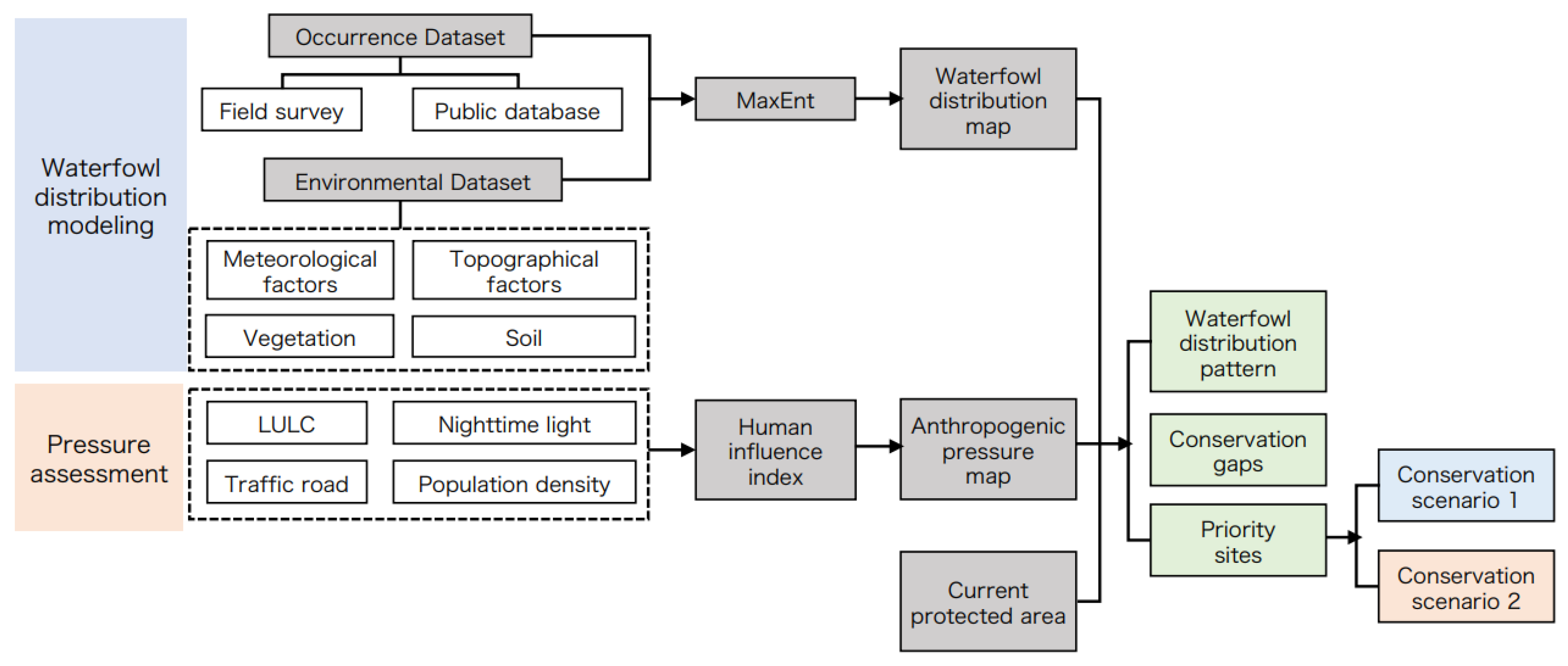
Figure 2 indicates a flowchart depicting the current study methodology. We assessed the conservation effectiveness of the HYRWNNR based on the integration of waterfowl distribution modeling and anthropogenic pressure assessment. First, MaxEnt was applied using threatened waterfowl occurrence data and environmental variables [36,37]. Subsequently, a human influence index integrating four index categories was proposed to assess human disturbance in the HYRWNNR [38]. Finally, the spatial pattern of human pressures and habitat suitability was superimposed with the bivariate spatial autocorrelation to interpret the conservation priority [39,40].

2.3. MaxEnt Prediction

2.3.1. Avifauna

We screened the threatened waterfowl species according to the following criteria: (1) the protected waterfowl was included in the List of Key Protected Wild Animals in China, first published in 1989, which contains a comprehensive and representative list of precious and threatened animal species. (2) The endangered bird species were embedded in the IUCN Red List of Threatened Species (https://www.iucnredlist.org/ (accessed on 27 August 2020)). (3) The birds that inhabit or often inhabit wetlands, including all birds of the Gaviiformes, Podicipediformes, Ciconiiformes, Anseriformes, and Charadriiforme. In addition, several birds of the Pelecaniformes, Gruiformes, and Coraciiformes.
Due to the relatively few occurrences and populations of threatened waterfowl, in the present study, we generate the occurrence dataset by combining records from field surveys and public databases. This is to improve the distribution model’s reliability. The field survey was continuously conducted from January 2019 to December 2020. We used the line transect method to establish multiple 500 m transects along the river and recorded the specific names of waterfowl we observed during our movement [41]. The investigation was conducted in clear weather the waterfowl observation probability. We used a 40 × 100 mm telescope to observe the waterfowl and recorded their location using a hand-held Global Positioning System (GPS) afterward. We only record waterfowl that explicitly use wetland habitats (e.g., foraging, resting, and moving between trees); waterfowls that fly by are not counted. Due to the inaccessibility of the water area, we estimate the geographical coordinates of the waterfowl observed on the water surface based on the approximate distance from the occurrence point to the shore. The field surveys yielded 203 records of 19 threatened waterfowl species. The search process in the public database is based on the 19 threatened waterfowls obtained from the field survey. The public data sources were the Bird Report (https://www.birdreport.cn/ (accessed on 11 January 2021)) and eBird (https://www.ebird.org/ (accessed on 12 January 2021)). We set the period and area parameters that are consistent with the field survey and input the scientific names of 19 species, respectively, to obtain their occurrence data. According to the combination of field survey data and a public database, we compiled 354 occurrence records for 19 species of threatened waterfowl (Table S1).
At last, we conducted data filtering to ensure data validity and minimize public data bias. The data filtering process includes two steps: (1) Deleted the occurrence records distributed outside the boundary of the HYRWNNR. (2) Imported the sampled records that were filtered in step one into ArcGIS (version 10.5), using the ‘Buffer’ tool to establish a 500 m buffer around each occurrence point, and placed these points and buffer information on a grating layer of 1 km × 1 km pixels [42,43]. To avoid the autocorrelation issues, records in each pixel were retained if there were less than three records, from which we removed one record with distances fewer than 500 m from others if they involved the same species [44]. After the filtering step, a total of 228 occurrence points remained for further model analysis.

2.3.2. Environmental Variables

Dramatic shifts in the ranges of waterfowl driven by temperature and precipitation have been documented in previous studies, and elevated temperatures might promote the migration of waterfowl to relatively high latitudes [45,46]. Precipitation has a significant impact on wetlands, which can alter the distribution of waterfowl and the structure of waterfowl communities [47]. Additionally, spatial topographic variation might affect the richness and distribution pattern of wildlife [48]. Therefore, to map the distribution of the 19 threatened waterfowl species, we adopted a range of variables related to meteorology, topography, vegetation, and soil (Table 1). Meteorological variables were obtained from WorldClim and interpolated to a 30″ resolution (~1 km grid cell) for further analysis. The elevation layer was extracted from the Google Earth Engine. For vegetation and soil layers, data are downloaded from the Resource and Environmental Science and Data Center. To minimize multicollinearity among the variables involved in the prediction, the Pearson correlation coefficient of variables was assessed by using SPSS (version 22.0) to ensure all variable pairs with Pearson’s correlation coefficient less than 0.7. Finally, 12 environmental variables with relatively low correlation and more obvious ecological significance were selected to provide information for waterfowl distribution modeling.

2.3.3. Model Operation and Validation

MaxEnt Software (version 3.4.2) was adopted to model the habitat suitability of the 19 threatened waterfowl species in HYRWNNR. The MaxEnt model parameters used in this study are as follows. A 75% portion of the occurrence data was randomly selected for training, whereas the remaining 25% was used for testing. “Bootstrap” was chosen as the replicated run type and was replicated 10 times. The maximum iterations ran 500 times, and the convergence threshold and prevalence were software defaults (0.00001 and 0.5, respectively). Ten thousand background points were also randomly generated from the whole study area [49].
To assess the SDM performance, we use the area (AUC) under the receiver operating curve. AUC is commonly used in SDM studies as a classification metric to evaluate the model’s ability to distinguish between the presence and absence of points. AUC ranges from 0 to 1, indicating the models with 0.75 < AUC < 0.85, 0.85 < AUC < 1 can be treated as providing good and excellent performance, respectively, while an AUC value lower than 0.5 indicates that the performance of the model is worse than that of a random classifier [36]. Besides, the relevance of variables and the contribution of each variable to the models were estimated using percent contribution, permutation importance, and Jackknife tests; the higher the value of the variable, the greater its influence.

2.4. Anthropogenic Pressure Assessment

2.4.1. Anthropogenic Pressure Data

The Yellow River’s Henan section is one of China’s most artificially developed and densely populated regions. Therefore, anthropogenic pressure is the major threat to biodiversity conservation in the HYRWNNR. The current study adopted a geospatial approach to efficiently evaluate the anthropogenic pressure. The HYRWNNR was divided into 1 km grids with the same resolution as the MaxEnt model. Then, anthropogenic pressure within each grid cell was quantified considering four types of direct/indirect pressures: land use and land cover (LULC), nighttime light intensity, population density, and road traffic condition.
Sentinel-2 images from April to May 2021 (cloud cover less than 5%) were downloaded from Google Earth Engine (GEE) platform and pre-processed by embedding, cloud removal, cropping, etc. [50]. Land use classification was carried out on the GEE platform according to the images. According to field investigation and previous studies, the land types in the study area were divided into 8 categories: farmland, woodland, grassland, water body, wetland, artificial surface, unused land, and fishpond (Figure 3). At the same time, the normalized vegetation index (NDVI), normalized differential water index (NDWI), and normalized differential building land index (NDBI) were calculated based on the image. Based on 30 m spatial resolution elevation data, topographic features such as slope, direction, and elevation were calculated. These indexes were calculated to improve land use classification accuracy. Finally, after manual interpretation and correction, the total land use classification accuracy was 88%, and the KAPPA coefficient was 0.86. See Table 2 for detailed information on anthropogenic pressure data.

2.4.2. Anthropogenic Pressure Assessment

A geospatial approach was adopted to estimate anthropogenic pressure in the study area. By superimposing a series of spatial elements related to human activities, including population density, railways, main roads, expressways, secondary roads, nighttime light, and land use types, the comprehensive human impact intensity index (HII) was obtained as a quantitative indicator to measure the impact of human activities on the wetland ecosystem [51]. After all kinds of data grids are reclassified, each factor is assigned from 0 to 10 concerning relevant literature (Table S2). The HII in the HYRWNNR was calculated as follows:
HII = Slanduse + Spopden + Snightlight + Straffic
where Slanduse represents the assigned score of land use (each land use type is scored according to the correlation with human activities), Spopden refers to the reassigned score of population density, Snightlight represents the assigned score of night light, and Straffic represents the summed scores of railways, expressways, main roads, and secondary roads. The HII value ranges from 0 (unmanned influence) to 58 (the strongest human impact obtained by this calculation method). The scoring method for each human element is based on Sanderson [38].
Lastly, to further explore how individual anthropogenic factors affect the richness of threatened waterfowl, the autoregressive model was performed according to MaxEnt the output and four categories of factors (i.e., population density, land cover, traffic accessibility, and nighttime light). The autoregressive model was built according to the equation as follows:
y = ρWy + Xβ + ε
where y is the interpreted variable matrix, X is the interpreted variable matrix, ρ is the spatial effect coefficient, β is a parameter vector, and W is a spatial matrix [52]. The result of the autoregressive model showed a high degree of fit (R2 = 0.834), indicating reliability. The autoregressive model was conducted with the “spatialreg” package in the R (version 4.1.0).

2.5. Conservation Prioritization

We combined the anthropogenic pressure with the waterfowl distribution map to identify the potential areas with the highest conservation priority or the greatest threat to threatened waterfowl. Unlike the previous research’s simple superposition of the species layer and disturbance layer, we adopt the bivariate spatial autocorrelation method to describe the spatial correlation and dependence characteristics of habitat suitability and anthropogenic disturbance. Here, GeoDa 1.6.7 was used for spatial analysis of the independent variables; bivariate spatial autocorrelation was assessed using global Moran’s I and local Moran’s I. The global Moran’s I was first calculated to reveal the overall correlation trend of the two variables, and local Moran’s I was further calculated and visualized on the study area map [53]. Finally, the result of local Moran’s I was divided into four aggregations: high-high (H-H), high-low (H-L), low-low (L-L), and low-high (L-H).
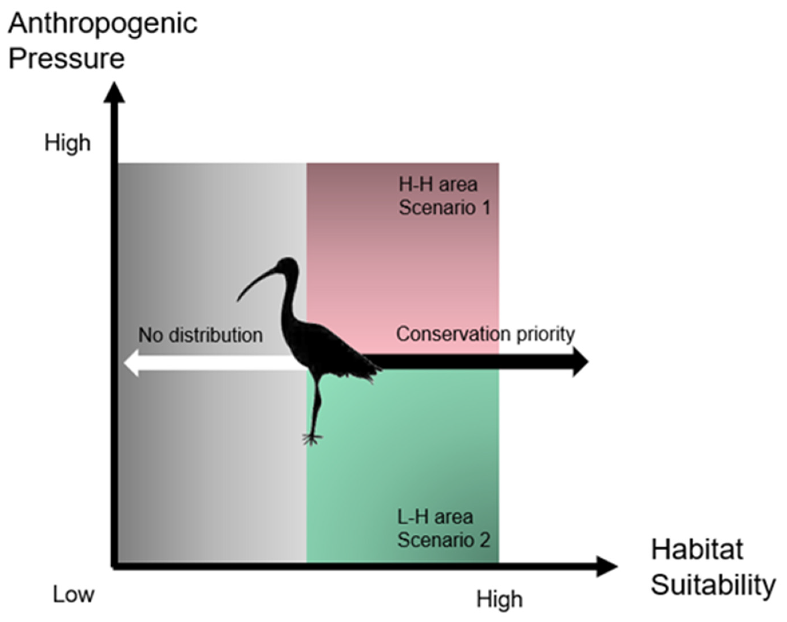
Based on the output of bivariate spatial autocorrelation, a two-dimensional conceptual framework was adopted to determine the conservation priorities (Figure 4): (1) The areas exhibiting high habitat suitability for waterfowl and low human pressure were most conducive to waterfowl conservation and habitat management, corresponding to the highest conservation priority. (2) The areas with high waterfowl habitat suitability and severe pressure indicate that although the current environment is suitable for waterfowl survival, habitats might be prone to degradation. However, due to the high maintenance costs, these areas are classified as secondary conservation priority areas in the current study. (3) The areas with low suitability of waterfowl habitats are not suitable for the survival and reproduction of waterfowls and are defined as the lowest conservation priority. Consequently, based on outcomes of the habitat suitability and anthropogenic pressure compared with the functional zoning of the HYRWNNR, three levels of priority zones were identified: The habitats with low waterfowl suitability (L-L/H-L areas) < The habitats with high waterfowl suitability and severe anthropogenic pressure (H-H areas) < The habitats with high waterfowl suitability and low anthropogenic pressure (L-H areas).

3. Results

3.1. Waterfowl Species Distribution

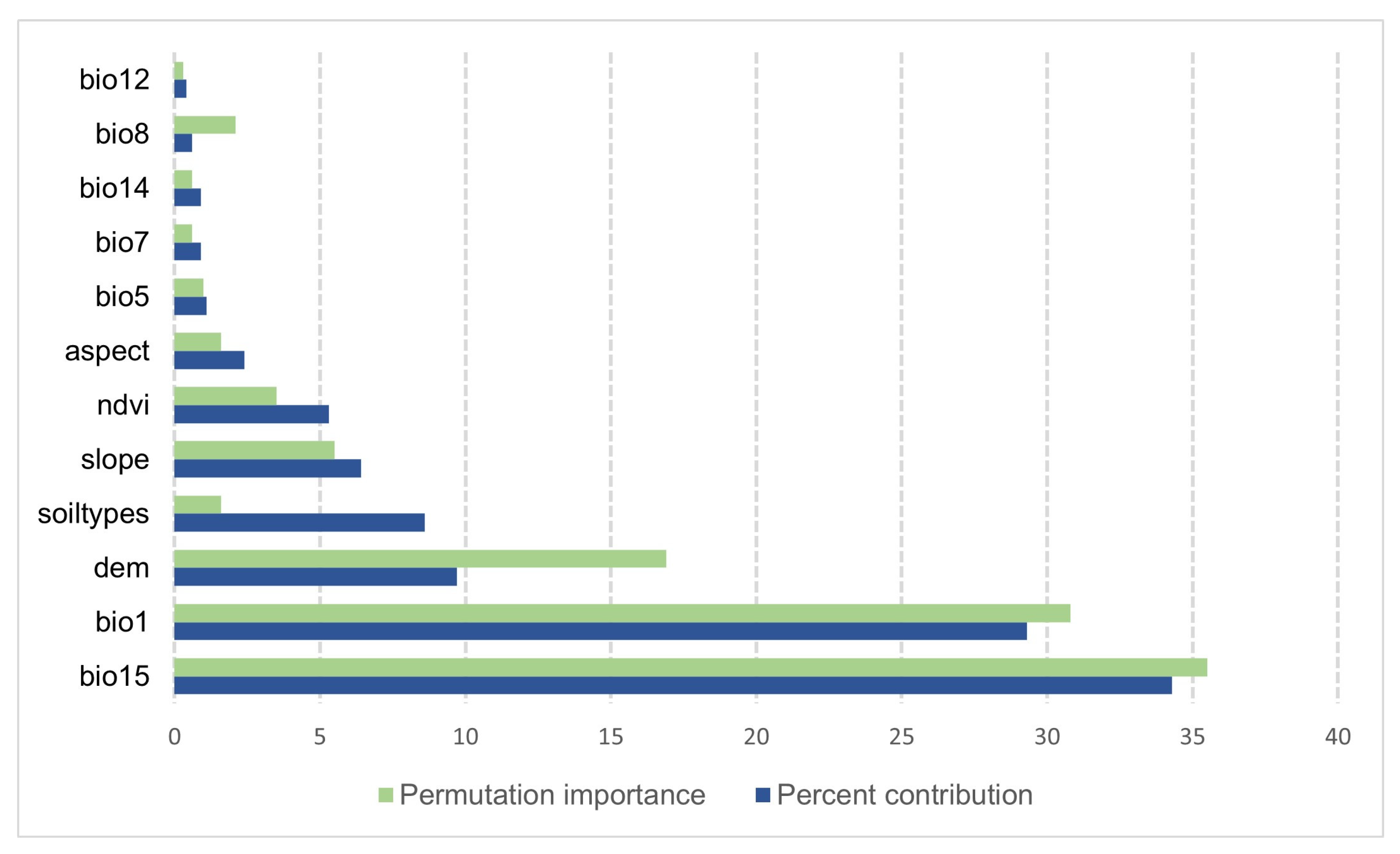
In the present study, the mean AUC value obtained from the MaxEnt model was 0.859, indicating that the simulation of the waterfowl distribution in the HYRWNNR using the MaxEnt was accurate (Figure S1). Moreover, each environmental variable’s importance based on the MaxEnt model was determined using percent contribution, permutation importance, and Jackknife tests. For the percent contribution, seasonal variation in precipitation (bio15, with 34.3% contribution), annual mean temperature (bio1, with 29.3% contribution), and altitude (DEM, with 9.7% contribution) were determined as the top three contributors. Permutation importance is the value that randomly displaces each environmental factor from the training presence and background data. Larger values indicate a stronger model dependence on that variable. Permutation importance values of environmental variables affecting the potential distribution of threatened waterfowl are shown in Figure 5. The results of jackknife tests that were shown in Figure S2, it can be concluded that when only a single environmental variable was used, the three environmental variables with the highest regularized training gain are: precipitation in the dry month (bio14, 0.2612), seasonal variation of precipitation (bio15, 0.2603), and annual mean temperature (bio1, 0.2295).
The habitat suitability map was generated by MaxEnt software. The logistic output of the MaxEnt is continuous, allowing for subtle differentiation between the modeled suitability of different regions of values between 0 and 1. Based on the results of the species occurrence and the suitability range determined by MaxEnt, the produced continuous map was classified into five grades: highly suitable (0.76–1), suitable (0.55–0.76), moderately suitable (0.36–0.55), less suitable (0.16–0.36), and unsuitable (0–0.16). The MaxEnt model found a highly suitable habitat, namely a distribution hotspot, predominantly in the east and central areas of the HYRWNNR. The suitable and moderately suitable habitats showed an aggregation trend, mainly distributed in the west of the HYRWNNR. The less suitable habitats showed a scattered distribution, but most of the area was located in the west of the HYRWNNR. The unsuited habitat was mainly characterized by waterbody, where few waterfowl were observed (Figure 6). Theoretically, natatorial birds behave closely related to the water surface; thus, a few waterfowl species remained inside the unsuitable habitat area. Still, the current study did not consider those distributions due to a deficiency of observation and complexity of river morphology.

3.2. Human Influence Index

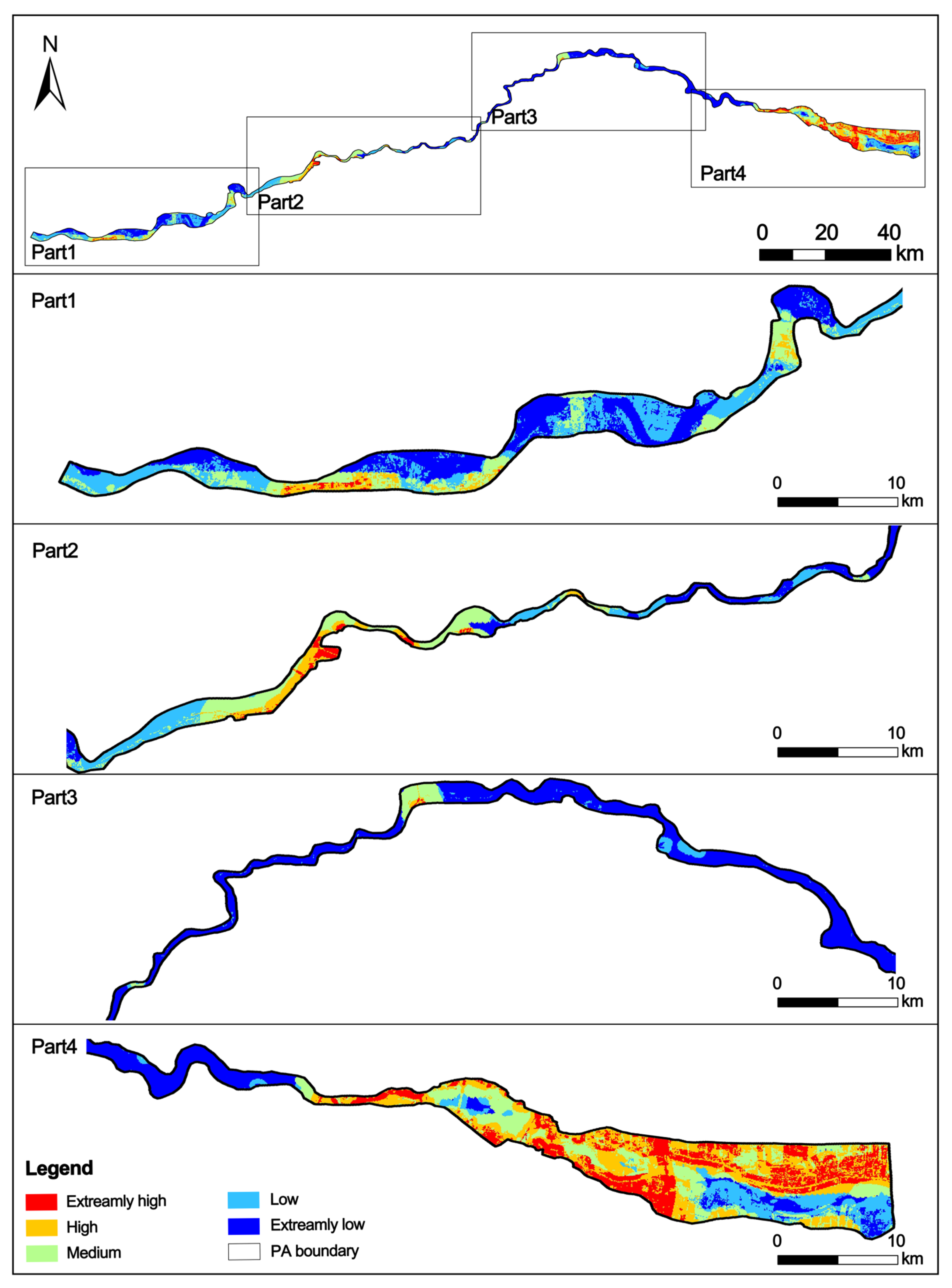
The human influence model results were classified in ArcGIS10.2 using the natural breakpoint method. These results were divided into five grades: extremely low, low, medium, high, and extremely high. Figure 7 shows the spatial patterns of human pressure. The areas under extremely high-intensity human pressure were characterized by dense rural residential areas and road networks, mainly distributed on the east and west of the HYRWNNR, accounting for 10.71% of the total area. The areas with high-intensity human pressure were mainly distributed in the west, accounting for 16.81% of the total area, which was mainly affected by farmland and secondary roads. The medium-intensity area was mainly located in the east and west areas, surrounded by rivers, wetlands, concentrated fishponds, and some sporadic settlements, accounting for 18.92% of the total area. These areas had flat terrain features, rich water resources, developed agriculture, and frequent farming. There was a fishpond, river channel, and forest grassland in the low-intensity area of the east. Within the HYRWNNR, 33.67% of the area was under extremely low-intensity human pressure. These areas were formed by river water, forest land, and grassland, and were mainly distributed in the middle of the nature reserve (Table S3).

3.3. Bivariate Spatial Autocorrelation Analysis

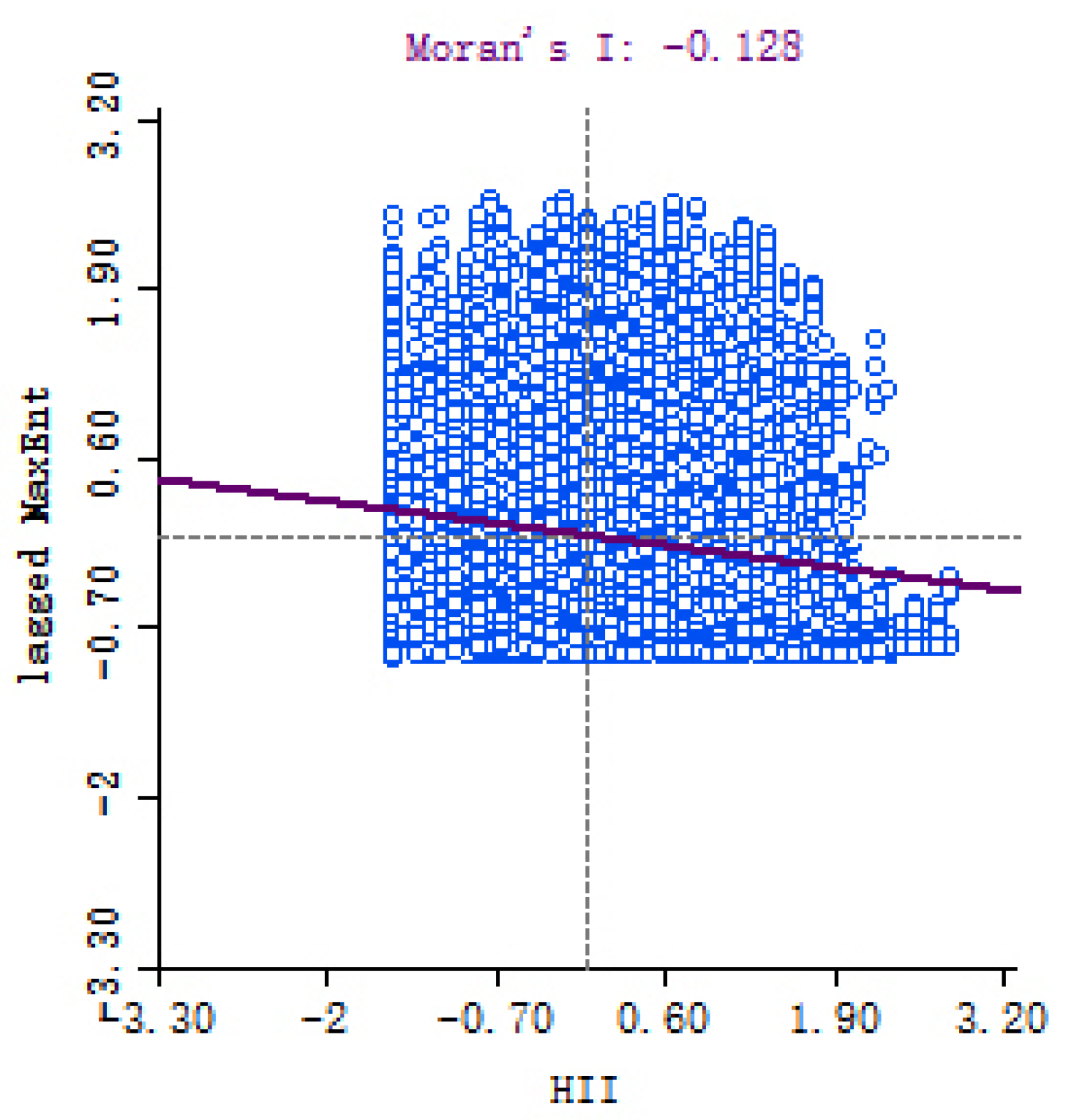
Using the comprehensive index of human influence, a Moran scatterplot was created (Figure 8). Randomization 999 was selected in GeoDa for the significance test. The results showed that the p-values were less than 0.001, indicating a significant negative spatial association between human influence and habitat suitability (Moran’s I = −0.128). Global assessment detected a negative correlation between human disturbance and waterfowl occurrence; many points occurred in the H-H quadrant. Thus, the local assessment is necessary to clarify the agglomeration differences in specific spatial locations.
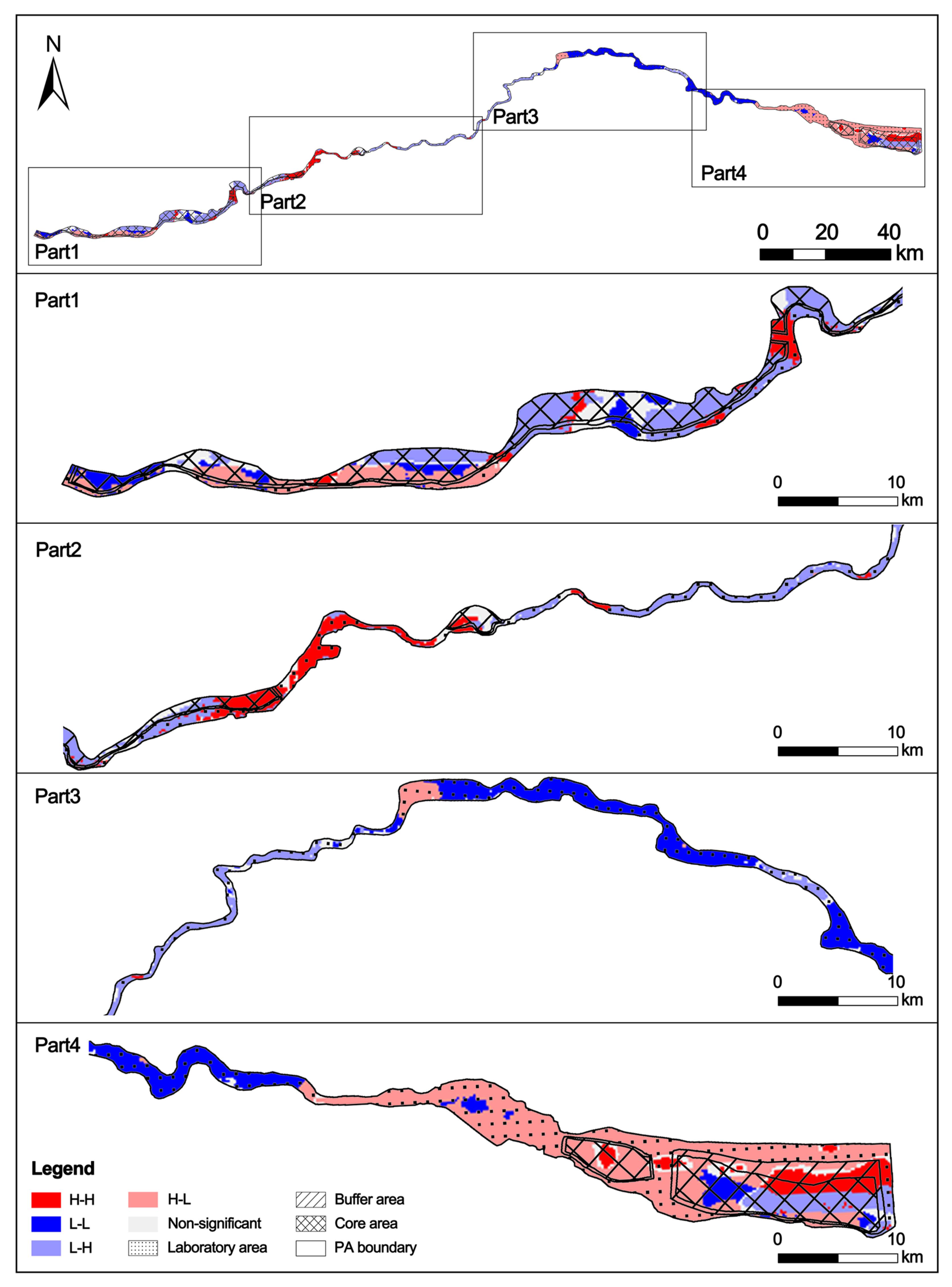
The results of local spatial autocorrelation analysis between human pressure and habitat distribution indicated that the four types of clusters were sporadically distributed in the HYRWNNR (Figure 9). H-H clusters indicate abundant waterfowl areas under intense human disturbance occurred in the west and east of nature reserves. Similarly, H-L clusters were also concentrated west and east of the HYRWNNR. L-H clusters indicate the area with a high waterfowl richness and under less anthropogenic pressure, distributed throughout the HYRWNNR. The area associated with L-H clusters belongs to Sanmenxia, Xiaolangdi, and Xixiayuan Reservoir Areas. Thus, relevant protection managements and policies provide an environment with limited human activities for waterfowl species’ foraging and inhabitation. L-L clusters are primarily located northeast of the HYRWNNR, meaning the involved areas have been affected by intensive human activities or are subjected to natural environmental constraints. Consequently, these habitats are unsuitable for waterfowl survival.
According to the result of the autoregressive model, the correlations between anthropogenic factors and habitat suitability were obtained, as shown in Table 3. Negative correlations were found among the traffic accessibility, nighttime light, and habitat suitability of threatened waterfowl. On the other hand, the correlations between population density, LULC, and habitat suitability were insignificant.

3.4. Identification of Conservation Gaps

The existing boundaries of the core area were compared against the priority areas obtained by species distribution and HII mapping. The priority areas were clarified as two scenarios in the current study based on human pressure intensity. The conservation priority areas ranked first in priority level were expressed as L-H areas, whereas it was that only 49% of L-H areas were covered by core areas. Moreover, the H-H areas were ranked second, and 58% of these areas overlapped with the core area. Overall, modeling of the threatened waterfowl species in the HYRWNNR showed a poor representation of high conservation priority areas within the existing management zone designation.

4. Discussion

4.1. Significance of the Framework

Ecological conservation and high-quality development of the Yellow River Basin is a channel for China to make significant contributions to global ecological security [35]; this study takes the HYRWNNR as an example, evaluating its effectiveness for biodiversity conservation by using threatened waterfowl as an indicator. We highlighted that serious conservation gaps exist in the HYRWNNR, and our study, together with other findings [54,55,56], can integrate solid bases for the biological conservation of the Yellow River Basin.
Due to their sensibility to human-dominated environments that make detections relatively rare, important gaps remain in knowledge of the distribution and ecology of threatened waterfowl species. Recent studies are beginning to address this issue by using extensive species databases (such as national species databases and museum records) and long-term monitoring data [19,21]. However, a number of developing countries face a lack of previously mentioned databases due to the limitation of manpower and financial resource constraints. The threatened waterfowl species data of the current study was primarily obtained from field surveys, which can provide basic information for wetland ecosystem management. Additionally, the umbrella effect of threatened species was discussed in previous studies [17,20]; thus, PAs that managed for threatened waterfowl species are expected to protect the majority of waterfowl species in these areas.
In addition, we determined the effectiveness of the HYRWNNR by combing the species distribution and human pressure. Previous studies have identified the correlation between human pressure and waterfowl in wetland ecosystems in terms of land use type, landscape fragmentation, human activity, and noise [15,27,30]. However, the associations between human pressure and waterfowl were rarely applied in the context of PAs, hindering the comprehensive assessment of PAs. In fact, the increasing intensity of development in the Yellow River basin over the last decades may have boosted the accelerated degradation of natural habitats [34], and we believe our findings can provide insights into improving the environmental resource management in the HYRWNNR, and serve as an example for regions around the world affected by anthropogenic disturbance.

4.2. Driving Factors for Threatened Waterfowl Distribution

Waterfowl, especially migratory birds, are potentially influenced by the climate conditions and human disturbance in wetlands, which can affect their migrating breeding, and foraging [57]. In terms of the MaxEnt model of waterfowl species distribution, precipitation in the driest month, seasonal variation of precipitation, and annual mean temperature are determined as the key driving factors. The previously mentioned result, in general, is consistent with the previous study, which stated that variations in precipitation and temperature affect the hydrology and vegetation of wetlands, thereby affecting the habitat selection for wetland-endemic species [58]. Specifically, temperature affects waterfowl metabolism, reproduction, and migration, which was confirmed as the determinant of the avifauna pattern [59]. Precipitation and seasonality result in wetland water level changes. Extensive research has shown that wetland water level is a vital factor in waterfowl foraging and habitat choice [60,61]. In addition to climate-related factors, the current study also confirmed the impact of topographical factors on geographical distribution, as altitude contributed 9% of the MaxEnt model. Altitude can indicate the habitat heterogeneity of the study areas, and they are significantly correlated with the local flora and climate conditions [62,63].
Besides natural environmental factors, anthropogenic pressure was determined as the factor for waterfowl species distribution patterns. High HII values are negatively correlated with the richness of threatened waterfowl. Thus, this study suggests that HII can be explored on a regional scale to predict human disturbance, as proven in the HYRWNNR for threatened waterfowl’s decline. Among the anthropogenic factors, traffic accessibility and nighttime light adversely affect the habitat suitability of threatened waterfowl. Light pollution has been reported as an increasing worldwide pressure for biodiversity, which might disrupt biological rhythms and decrease species richness [64]. Furthermore, intensive road construction causes sharp reduction and fragmentation in wetland habitats, such that waterfowl habitat suitability changes [65]. The resulting environmental change might lead to a serious change in waterfowl spatial distribution and exert a significant negative effect on waterfowl richness and diversity. It is noteworthy that although some existing research on patterns of avian distribution on a regional scale has considered human demography as a factor in avian communities, most research has reported a negative correlation between avian richness and population density, not consistent with the results of existing research [66,67]. In the current study, the insignificant association between human population density and threatened waterfowls might be attributed to the following reasons: Firstly, the above pattern may be because in certain regions, both humans and wildlife are seeking the most productive ecosystems, which alleviates the contradiction between humans and waterfowls; Secondly, the aggregation of humans might not have a direct impact on waterfowls, and the main threat might come from the intensity and type of human activity.

4.3. Management Suggestions

Evaluating potential causes of conservation gaps in this study revealed several implications for optimal biodiversity conservation. First, a comprehensive monitoring system should be developed, as long-term and full-coverage field surveys on waterfowl determine the potential for modeling and the effectiveness of assessing the HYRWNNR. Moreover, this study suggests that the proposed conservation framework should be used and undertaken periodically to increase the conservation effectiveness of the HYRWNNR through the evaluation of the ecological environment and human pressure. Furthermore, we superimposed human activities and regional threats based on the predicted distribution of threatened waterfowl. Finally, we generated two scenarios to contribute to the biodiversity conservation and restoration site selection.
In the scenario of the L-H areas, an effective long-term protection plan should be formulated, and wetlands’ ecological functions can be protected and restored based on a unified consideration of the regional species’ resources and geographical environment. Various measures can be taken to strengthen protection in key areas where threatened birds are concentrated (e.g., filling the existing protection gaps by building new protected areas, upgrading existing protected areas, establishing protected areas, and launching special protection actions in key habitats of non-protected areas). Since there are still fishponds and farmlands in the HYRWNNR, local administrators should establish relatively strict construction permits or a reward and punishment system (e.g., incentive measures to encourage residents to report violations) and impose strict penalties for violations.
As indicated by the areas located in the H-H category, despite the coexistence of waterfowl hotspots and human disturbance, waterfowl still have degradation risk in suitable areas that exhibit high human pressure. For the case of the H-H areas, this study suggests that it is imperative for policymakers, environmental agencies, and managers of the HYRWNNR to integrate a management framework for effectively coordinating the contradiction between urban development and wetland conservation. First, the fishponds and farmlands distributed in the areas mentioned above should be ecologically restored by rewilding measures for reconstructing the waterfowl ecological niche and food chain. Second, administrators can control the intensity of anthropogenic activities by monitoring local land-use change trends. Considering that artificial activities and fragmentation of wetland ecosystems are the primary threats to waterfowl species, anthropogenic data are one of the most effective conservation tools. Lastly, the gap areas can be taken as the potential location of the wetland parks based on scientific research in the background survey (e.g., human pressure, environmental resources, avian species distribution).

4.4. Strengths and Limitations of the Study

The research framework of this study can be applied in similar regions to assess PAs conservation effectiveness. Specifically, the present study has several important strengths. The threatened waterfowl species were set as biological indicators to evaluate the protected area’s effectiveness, filling the current knowledge gap about these species. Also, in our methodological framework, conservation priorities are assessed by MaxEnt and HII. This makes it possible to support precise conservation strategies according to different levels of human pressure.
However, several limitations should be discussed. First, this study was cross-sectional, with species and environmental data mainly collected in 2019–2020. Due to the lagging response of species to environmental changes, cross-sectional data might entail bias that cannot fully characterize the response mechanism of species-environmental change. Second, although the HII can provide a realistic reflection of anthropogenic pressure, the accuracy of data applied to HII needs to be improved. Here, due to the unavailability of precise data, we set the LULC pressure based on expert knowledge and parameters reflecting the LULC types in the HYRWNNR. Therefore, follow-up studies should optimize the human pressure characterization, and explore the response mechanism of avian biodiversity to environmental changes from the perspective of dynamic evolution.

5. Conclusions

A comprehensive conservation assessment of the effectiveness of function zoning of PA in protecting threatened waterfowl species was conducted in the middle and lower reaches of the Yellow River, China. It could be concluded that natural environmental factors and human pressure determine the geographical distribution of threatened waterfowl. Thus, conservation strategies should be established based on the careful consideration of natural and artificial factors. Firstly, this study revealed that the core area did not occupy a large area of waterfowl biodiversity hotspots, indicating serious conservation gaps existed in the HYRWNNR. Secondly, based on the distribution of threatened waterfowl, we superimposed anthropogenic pressure and regional threats and generated two scenarios to contribute to the site selection for biodiversity conservation and restoration. The method can support precise conservation strategies for wetlands and can be used as a standard component of global biodiversity assessment and conservation approaches.

Supplementary Materials

The following supporting information can be downloaded at: https://www.mdpi.com/article/10.3390/land12061250/s1, Figure S1: AOC values of ROC curves; Figure S2: The jackknife test result of environment factor; Table S1: The threatened waterfowl species investigated during field survey; Table S2: Assignment method for each anthropogenic factors; Table S3: The overlaped proportion between protected area and area within different degree of anthropogenic pressure.

Author Contributions

Conceptualization, Y.C. and Y.L.; Data curation, N.D.; Funding acquisition, Y.L.; Investigation, Y.C.; Methodology, Y.C., S.W. and Y.L.; Resources, Y.L.; Software, Y.C. and S.W.; Supervision, G.T.; Validation, N.D.; Writing—original draft, Y.C. and S.W.; Writing—review and editing, G.T. and Y.L. All authors have read and agreed to the published version of the manuscript.

Funding

This research was funded by Henan Province Key R&D and Promotion Special Project (232400410293), Henan Province International Cooperation Research Project (HNGD2021035), and the 2021 Research and Practice Project of Higher Education Teaching Reform in Henan Province (2021SJGLX162Y).

Data Availability Statement

The data presented in this study are available on request from the first author.

Acknowledgments

We would like to thank Jingsheng Zhang and Huimin Geng for their strong support during the process of framework construction. We are grateful to Noelikanto Ramamonjisoa, a researcher at Environmental Studies, Kyoto University, Japan, for the language assistance. The authors gratefully appreciate editors and reviewers for their constructive comments.

Conflicts of Interest

The authors declare no conflict of interest.

References

  1. Junk, W.J.; An, S.; Finlayson, C.M.; Gopal, B.; Květ, J.; Mitchell, S.A.; Mitsch, W.J.; Robarts, R.D. Current state of knowledge regarding the world’s wetlands and their future under global climate change: A synthesis. Aquat. Sci. 2013, 75, 151–167. [Google Scholar] [CrossRef] [Green Version]
  2. Fluet-Chouinard, E.; Stocker, B.D.; Zhang, Z.; Malhotra, A.; Melton, J.R.; Poulter, B.; Kaplan, J.O.; Goldewijk, K.K.; Siebert, S.; Minayeva, T.; et al. Extensive global wetland loss over the past three centuries. Nature 2023, 614, 281–286. [Google Scholar] [CrossRef] [PubMed]
  3. Mammides, C. A global assessment of the human pressure on the world’s lakes. Glob. Environ. Chang. 2020, 63, 102084. [Google Scholar] [CrossRef]
  4. Rosenberg, K.V.; Dokter, A.M.; Blancher, P.J.; Sauer, J.R.; Smith, A.C.; Smith, P.A.; Stanton, J.C.; Panjabi, A.; Helft, L.; Parr, M.; et al. Decline of the North American avifauna. Science 2019, 366, 120–124. [Google Scholar] [CrossRef]
  5. Collen, B.; Whitton, F.; Dyer, E.E.; Baillie, J.E.M.; Cumberlidge, N.; Darwall, W.R.T.; Pollock, C.; Richman, N.I.; Soulsby, A.-M.; Böhm, M. Global patterns of freshwater species diversity, threat and endemism. Glob. Ecol. Biogeogr. 2014, 23, 40–51. [Google Scholar] [CrossRef] [PubMed] [Green Version]
  6. Tickner, D.; Opperman, J.J.; Abell, R.; Acreman, M.; Arthington, A.H.; Bunn, S.E.; Cooke, S.J.; Dalton, J.; Darwall, W.; Edwards, G.; et al. Bending the Curve of Global Freshwater Biodiversity Loss: An Emergency Recovery Plan. BioScience 2020, 70, 330–342. [Google Scholar] [CrossRef] [PubMed] [Green Version]
  7. Lu, M.; Zou, Y.; Xun, Q.; Yu, Z.; Jiang, M.; Sheng, L.; Lu, X.; Wang, D. Anthropogenic disturbances caused declines in the wetland area and carbon pool in China during the last four decades. Glob. Chang. Biol. 2021, 27, 3837–3845. [Google Scholar] [CrossRef]
  8. Watson, J.E.M.; Dudley, N.; Segan, D.B.; Hockings, M. The performance and potential of protected areas. Nature 2014, 515, 67–73. [Google Scholar] [CrossRef]
  9. Barocas, A.; Tobler, M.W.; Abanto Valladares, N.; Alarcon Pardo, A.; Macdonald, D.W.; Swaisgood, R.R. Protected areas maintain neotropical freshwater bird biodiversity in the face of human activity. Ecol. Indic. 2023, 150, 110256. [Google Scholar] [CrossRef]
  10. Hermoso, V.; Carvalho, S.B.; Giakoumi, S.; Goldsborough, D.; Katsanevakis, S.; Leontiou, S.; Markantonatou, V.; Rumes, B.; Vogiatzakis, I.N.; Yates, K.L. The EU Biodiversity Strategy for 2030: Opportunities and challenges on the path towards biodiversity recovery. Environ. Sci. Policy 2022, 127, 263–271. [Google Scholar] [CrossRef]
  11. Geldmann, J.; Manica, A.; Burgess, N.D.; Coad, L.; Balmford, A. A global-level assessment of the effectiveness of protected areas at resisting anthropogenic pressures. Proc. Natl. Acad. Sci. USA 2019, 116, 23209–23215. [Google Scholar] [CrossRef] [PubMed]
  12. Chen, H.; Zhang, T.; Costanza, R.; Kubiszewski, I. Review of the approaches for assessing protected areas’ effectiveness. Environ. Impact Assess. Rev. 2023, 98, 106929. [Google Scholar] [CrossRef]
  13. Wauchope, H.S.; Jones, J.P.G.; Geldmann, J.; Simmons, B.I.; Amano, T.; Blanco, D.E.; Fuller, R.A.; Johnston, A.; Langendoen, T.; Mundkur, T.; et al. Protected areas have a mixed impact on waterbirds, but management helps. Nature 2022, 605, 103–107. [Google Scholar] [CrossRef] [PubMed]
  14. Zhang, L.; Ouyang, Z. Focusing on rapid urbanization areas can control the rapid loss of migratory water bird habitats in China. Glob. Ecol. Conserv. 2019, 20, e00801. [Google Scholar] [CrossRef]
  15. McDuie, F.; Lorenz, A.A.; Klinger, R.C.; Overton, C.T.; Feldheim, C.L.; Ackerman, J.T.; Casazza, M.L. Informing wetland management with waterfowl movement and sanctuary use responses to human-induced disturbance. J. Environ. Manag. 2021, 297, 113170. [Google Scholar] [CrossRef]
  16. Sun, X.; Shen, J.; Xiao, Y.; Li, S.; Cao, M. Habitat suitability and potential biological corridors for waterbirds in Yancheng coastal wetland of China. Ecol. Indic. 2023, 148, 110090. [Google Scholar] [CrossRef]
  17. Wang, C.; Liu, H.; Li, Y.; Dong, B.; Qiu, C.; Yang, J.; Zong, Y.; Chen, H.; Zhao, Y.; Zhang, Y. Study on habitat suitability and environmental variable thresholds of rare waterbirds. Sci. Total Environ. 2021, 785, 147316. [Google Scholar] [CrossRef]
  18. Wang, C.; Zhou, Y.; Zhang, H.; Li, Y.; Liu, H.; Dong, B. Study on the rare waterbird habitat networks of a new UNESCO World Natural Heritage site based on scenario simulation. Sci. Total Environ. 2022, 843, 157058. [Google Scholar] [CrossRef]
  19. Kim, J.H.; Park, S.; Kim, S.H.; Lee, E.J. Identifying high-priority conservation areas for endangered waterbirds using a flagship species in the Korean DMZ. Ecol. Eng. 2021, 159, 106080. [Google Scholar] [CrossRef]
  20. Holopainen, S.; Čehovská, M.; Jaatinen, K.; Laaksonen, T.; Lindén, A.; Nummi, P.; Piha, M.; Pöysä, H.; Toivanen, T.; Väänänen, V.-M.; et al. A rapid increase of large-sized waterfowl does not explain the population declines of small-sized waterbird at their breeding sites. Glob. Ecol. Conserv. 2022, 36, e02144. [Google Scholar] [CrossRef]
  21. Barnes, A.E.; Davies, J.G.; Martay, B.; Boersch-Supan, P.H.; Harris, S.J.; Noble, D.G.; Pearce-Higgins, J.W.; Robinson, R.A. Rare and declining bird species benefit most from designating protected areas for conservation in the UK. Nat. Ecol. Evol. 2023, 7, 92–101. [Google Scholar] [CrossRef] [PubMed]
  22. Marolla, F.; Aarvak, T.; Hamel, S.; Ims, R.A.; Kéry, M.; Mellard, J.P.; Nater, C.R.; Schaub, M.; Vougioukalou, M.; Yoccoz, N.G.; et al. Life-cycle analysis of an endangered migratory goose to assess the impact of conservation actions on population recovery. Biol. Conserv. 2023, 281, 110028. [Google Scholar] [CrossRef]
  23. El-Gabbas, A.; Gilbert, F.; Dormann, C.F. Spatial conservation prioritisation in data-poor countries: A quantitative sensitivity analysis using multiple taxa. BMC Ecol. 2020, 20, 35. [Google Scholar] [CrossRef]
  24. De Silva, S. Need for longitudinal studies of Asian wildlife in the face of crises. Glob. Ecol. Conserv. 2016, 6, 276–285. [Google Scholar] [CrossRef] [Green Version]
  25. Sun, X.; Liu, W.; Li, S.; Chen, P.; Cao, M.; Randhir, T.O.; Zhang, Y. Species richness patterns of waterbirds overwintering on the Jiangsu coast for coastal reclamation. Ocean Coast. Manag. 2021, 205, 105488. [Google Scholar] [CrossRef]
  26. Zhao, Q.; Boomer, G.S.; Kendall, W.L. The non-linear, interactive effects of population density and climate drive the geographical patterns of waterfowl survival. Biol. Conserv. 2018, 221, 1–9. [Google Scholar] [CrossRef]
  27. Xu, Y.; Si, Y.; Yin, S.; Zhang, W.; Grishchenko, M.; Prins, H.H.T.; Gong, P.; de Boer, W.F. Species-dependent effects of habitat degradation in relation to seasonal distribution of migratory waterfowl in the East Asian–Australasian Flyway. Landsc. Ecol. 2019, 34, 243–257. [Google Scholar] [CrossRef] [Green Version]
  28. Kahara, S.N.; Skalos, D.; Madurapperuma, B.; Hernandez, K. Habitat quality and drought effects on breeding mallard and other waterfowl populations in California, USA. J. Wildl. Manag. 2022, 86, e22133. [Google Scholar] [CrossRef]
  29. Zhang, W.; Li, X.; Yu, L.; Si, Y. Multi-scale habitat selection by two declining East Asian waterfowl species at their core spring stopover area. Ecol. Indic. 2018, 87, 127–135. [Google Scholar] [CrossRef]
  30. Timmers, R.; van Kuijk, M.; Verweij, P.A.; Ghazoul, J.; Hautier, Y.; Laurance, W.F.; Arriaga-Weiss, S.L.; Askins, R.A.; Battisti, C.; Berg, Å.; et al. Conservation of birds in fragmented landscapes requires protected areas. Front. Ecol. Environ. 2022, 20, 361–369. [Google Scholar] [CrossRef]
  31. Gao, B.; Gong, P.; Zhang, W.; Yang, J.; Si, Y. Multiscale effects of habitat and surrounding matrices on waterbird diversity in the Yangtze River Floodplain. Landsc. Ecol. 2021, 36, 179–190. [Google Scholar] [CrossRef]
  32. Shrestha, N.; Xu, X.; Meng, J.; Wang, Z. Vulnerabilities of protected lands in the face of climate and human footprint changes. Nat. Commun. 2021, 12, 1632. [Google Scholar] [CrossRef] [PubMed]
  33. Xu, W.; Xiao, Y.; Zhang, J.; Yang, W.; Zhang, L.; Hull, V.; Wang, Z.; Zheng, H.; Liu, J.; Polasky, S.; et al. Strengthening protected areas for biodiversity and ecosystem services in China. Proc. Natl. Acad. Sci. USA 2017, 114, 1601–1606. [Google Scholar] [CrossRef] [PubMed] [Green Version]
  34. Zhang, P.; Li, X.; Yu, Y. Relationship between ecosystem services and farmers’ well-being in the Yellow River Wetland Nature Reserve of China. Ecol. Indic. 2023, 146, 109810. [Google Scholar] [CrossRef]
  35. Wei, Z.; Jian, Z.; Sun, Y.; Pan, F.; Han, H.; Liu, Q.; Mei, Y. Ecological sustainability and high-quality development of the Yellow River Delta in China based on the improved ecological footprint model. Sci. Rep. 2023, 13, 3821. [Google Scholar] [CrossRef]
  36. Merow, C.; Smith, M.J.; Silander, J.A., Jr. A practical guide to MaxEnt for modeling species’ distributions: What it does, and why inputs and settings matter. Ecography 2013, 36, 1058–1069. [Google Scholar] [CrossRef]
  37. Na, X.; Zhou, H.; Zang, S.; Wu, C.; Li, W.; Li, M. Maximum Entropy modeling for habitat suitability assessment of Red-crowned crane. Ecol. Indic. 2018, 91, 439–446. [Google Scholar] [CrossRef]
  38. Sanderson, E.W.; Jaiteh, M.; Levy, M.A.; Redford, K.H.; Wannebo, A.V.; Woolmer, G. The Human Footprint and the Last of the Wild: The human footprint is a global map of human influence on the land surface, which suggests that human beings are stewards of nature, whether we like it or not. BioScience 2002, 52, 891–904. [Google Scholar] [CrossRef] [Green Version]
  39. Santangeli, A.; Girardello, M.; Buechley, E.R.; Eklund, J.; Phipps, W.L. Navigating spaces for implementing raptor research and conservation under varying levels of violence and governance in the Global South. Biol. Conserv. 2019, 239, 108212. [Google Scholar] [CrossRef]
  40. Sokal, R.R.; Thomson, J.D. Applications of Spatial Autocorrelation in Ecology. In Develoments in Numerical Ecology; NATO ASI Series; Springer: Berlin/Heidelberg, Germany, 1987; pp. 431–466. [Google Scholar]
  41. Samanta, S.; Das, D.; Mandal, S. Diversity, status and guild structure of the avifauna in the Ajodhya Foothills, Baghmundi, Purulia, West Bengal, India. Trop. Ecol. 2022, 64, 211–223. [Google Scholar] [CrossRef]
  42. Huang, Z.; Bai, Y.; Alatalo, J.M.; Yang, Z. Mapping biodiversity conservation priorities for protected areas: A case study in Xishuangbanna Tropical Area, China. Biol. Conserv. 2020, 249, 108741. [Google Scholar] [CrossRef]
  43. Li, Y.; Nigh, T. GIS-based prioritization of private land parcels for biodiversity conservation: A case study from the Current and Eleven Point Conservation Opportunity Areas, Missouri. Appl. Geogr. 2011, 31, 98–107. [Google Scholar] [CrossRef]
  44. Yackulic, C.B.; Chandler, R.; Zipkin, E.F.; Royle, J.A.; Nichols, J.D.; Campbell Grant, E.H.; Veran, S. Presence-only modelling using MAXENT: When can we trust the inferences? Methods Ecol. Evol. 2013, 4, 236–243. [Google Scholar] [CrossRef]
  45. Li, X.; Anderson, C.J.; Wang, Y.; Lei, G. Waterbird diversity and abundance in response to variations in climate in the Liaohe Estuary, China. Ecol. Indic. 2021, 132, 108286. [Google Scholar] [CrossRef]
  46. Amano, T.; Székely, T.; Wauchope, H.S.; Sandel, B.; Nagy, S.; Mundkur, T.; Langendoen, T.; Blanco, D.; Michel, N.L.; Sutherland, W.J. Responses of global waterbird populations to climate change vary with latitude. Nat. Clim. Chang. 2020, 10, 959–964. [Google Scholar] [CrossRef]
  47. Withey, P.; van Kooten, G.C. The effect of climate change on optimal wetlands and waterfowl management in Western Canada. Ecol. Econ. 2011, 70, 798–805. [Google Scholar] [CrossRef]
  48. Amatulli, G.; Domisch, S.; Tuanmu, M.-N.; Parmentier, B.; Ranipeta, A.; Malczyk, J.; Jetz, W. A suite of global, cross-scale topographic variables for environmental and biodiversity modeling. Sci. Data 2018, 5, 180040. [Google Scholar] [CrossRef] [PubMed] [Green Version]
  49. Lin, J.; Li, H.; Zeng, Y.; He, X.; Zhuang, Y.; Liang, Y.; Lu, S. Estimating potential illegal land development in conservation areas based on a presence-only model. J. Environ. Manag. 2022, 321, 115994. [Google Scholar] [CrossRef]
  50. Tamiminia, H.; Salehi, B.; Mahdianpari, M.; Quackenbush, L.; Adeli, S.; Brisco, B. Google Earth Engine for geo-big data applications: A meta-analysis and systematic review. ISPRS J. Photogramm. Remote Sens. 2020, 164, 152–170. [Google Scholar] [CrossRef]
  51. De Oliveira, M.L.; Peres, P.H.d.F.; Grotta-Neto, F.; Vogliotti, A.; Passos, F.d.C.; Duarte, J.M.B. Using niche modelling and human influence index to indicate conservation priorities for Atlantic forest deer species. J. Nat. Conserv. 2022, 69, 126262. [Google Scholar] [CrossRef]
  52. Ver Hoef, J.M.; Peterson, E.E.; Hooten, M.B.; Hanks, E.M.; Fortin, M.-J. Spatial autoregressive models for statistical inference from ecological data. Ecol. Monogr. 2018, 88, 36–59. [Google Scholar] [CrossRef] [Green Version]
  53. Lee, S.-I. Developing a bivariate spatial association measure: An integration of Pearson’s r and Moran’s I. J. Geogr. Syst. 2001, 3, 369–385. [Google Scholar] [CrossRef]
  54. Huang, L.; Wang, J.; Chen, X. Ecological infrastructure planning of large river basin to promote nature conservation and ecosystem functions. J. Environ. Manag. 2022, 306, 114482. [Google Scholar] [CrossRef]
  55. Kang, J.; Li, C.; Li, M.; Zhang, T.; Zhang, B. Identifying priority areas for conservation in the lower Yellow River basin from an ecological network perspective. Ecosyst. Health Sustain. 2022, 8, 2105751. [Google Scholar] [CrossRef]
  56. Yi, S.; Wu, P.; Peng, X.; Tang, Z.; Bai, F.; Sun, X.; Gao, Y.; Qin, H.; Yu, X.; Wang, R.; et al. Biodiversity, environmental context and structural attributes as drivers of aboveground biomass in shrublands at the middle and lower reaches of the Yellow River basin. Sci. Total Environ. 2021, 774, 145198. [Google Scholar] [CrossRef] [PubMed]
  57. Blake-Bradshaw, A.G.; Lancaster, J.D.; O’Connell, J.R.; Matthews, J.W.; Eichholz, M.W.; Hagy, H.M. Suitability of Wetlands for Migrating and Breeding Waterbirds in Illinois. Wetlands 2020, 40, 1993–2010. [Google Scholar] [CrossRef]
  58. Poiani, K.A.; Johnson, W.C.; Kittel, T.G.F. Sensitivity of a prairie wetland to increased temperature and seasonal precipitation changes. JAWRA J. Am. Water Resour. Assoc. 1995, 31, 283–294. [Google Scholar] [CrossRef]
  59. Rahbek, C.; Gotelli, N.J.; Colwell, R.K.; Entsminger, G.L.; Rangel, T.F.L.V.B.; Graves, G.R. Predicting continental-scale patterns of bird species richness with spatially explicit models. Proc. R. Soc. B Biol. Sci. 2006, 274, 165–174. [Google Scholar] [CrossRef] [PubMed] [Green Version]
  60. Casazza, M.L.; McDuie, F.; Jones, S.; Lorenz, A.A.; Overton, C.T.; Yee, J.; Feldheim, C.L.; Ackerman, J.T.; Thorne, K.M. Waterfowl use of wetland habitats informs wetland restoration designs for multi-species benefits. J. Appl. Ecol. 2021, 58, 1910–1920. [Google Scholar] [CrossRef]
  61. Ma, Z.; Cai, Y.; Li, B.; Chen, J. Managing Wetland Habitats for Waterbirds: An International Perspective. Wetlands 2010, 30, 15–27. [Google Scholar] [CrossRef]
  62. Stokes, A.; Angeles, G.; Anthelme, F.; Aranda-Delgado, E.; Barois, I.; Bounous, M.; Cruz-Maldonado, N.; Decaëns, T.; Fourtier, S.; Freschet, G.T.; et al. Shifts in soil and plant functional diversity along an altitudinal gradient in the French Alps. BMC Res. Notes 2021, 14, 54. [Google Scholar] [CrossRef] [PubMed]
  63. Bhandari, J.; Zhang, Y. Effect of altitude and soil properties on biomass and plant richness in the grasslands of Tibet, China, and Manang District, Nepal. Ecosphere 2019, 10, e02915. [Google Scholar] [CrossRef] [Green Version]
  64. Sordello, R.; Busson, S.; Cornuau, J.H.; Deverchère, P.; Faure, B.; Guetté, A.; Hölker, F.; Kerbiriou, C.; Lengagne, T.; Le Viol, I.; et al. A plea for a worldwide development of dark infrastructure for biodiversity—Practical examples and ways to go forward. Landsc. Urban Plan. 2022, 219, 104332. [Google Scholar] [CrossRef]
  65. Cooke, S.C.; Balmford, A.; Donald, P.F.; Newson, S.E.; Johnston, A. Roads as a contributor to landscape-scale variation in bird communities. Nat. Commun. 2020, 11, 3125. [Google Scholar] [CrossRef]
  66. Gagné, S.A.; Sherman, P.J.; Singh, K.K.; Meentemeyer, R.K. The effect of human population size on the breeding bird diversity of urban regions. Biodivers. Conserv. 2016, 25, 653–671. [Google Scholar] [CrossRef]
  67. Latta, S.C.; Musher, L.J.; Latta, K.N.; Katzner, T.E. Influence of human population size and the built environment on avian assemblages in urban green spaces. Urban Ecosyst. 2013, 16, 463–479. [Google Scholar] [CrossRef]
Figure 1. Map of the study area.
Land 12 01250 g001
Figure 2. Methodology flowchart.
Land 12 01250 g002
Figure 3. Land use in the HYRWNNR.
Land 12 01250 g003
Figure 4. The conceptual framework for identifying potential conservation areas in the HYRWNNR.
Land 12 01250 g004
Figure 5. Contribution of environmental variables. Abbreviations: bio1—Annual average temperature, the bio5—Max temperature of the warmest month, bio7—Temperature annual range, the bio8—Mean temperature of the wettest quarter, bio12—Annual Precipitation, bio14—Precipitation of the driest month, bio15—Precipitation Seasonality.
Land 12 01250 g005
Figure 6. Location of five categories of suitable areas for biodiversity hotspots of threatened waterfowl in the HYRWNNR based on the MaxEnt model.
Land 12 01250 g006
Figure 7. Location of five categories of different human influence in the HYRWNNR.
Land 12 01250 g007
Figure 8. Moran scatterplot for human pressure and distribution of suitable habitat.
Land 12 01250 g008
Figure 9. Distribution of significant LISAs for human pressure and distribution of suitable habitat.
Land 12 01250 g009
Table 1. The environmental variables adopted in the models.
VariablesIndicatorsPeriodData SourcesData Processing
Meteorological factorsBio1, Bio5, Bio7, Bio8, Bio12, Bio14, Bio152020WorldClim (https://worldclim.org/ (accessed on 7 May 2022))Random value points were extracted and then interpolated to 30″ (~1 km grid cell) resolution
Topographical factorsAltitude, Slope, Aspect2020Google Earth Engine (https://www.earthengine.google.com/ (accessed on 10 May 2022))Clipped after downloading and kept at their native resolution of 30 m
VegetationNormalized Difference Vegetation Index (NDVI)2020Resource and Environmental Science and Data Center (https://www.resdc.cn/ (accessed on 12 May 2022))Calculated from red and near-infrared (NIR) values as: (rNIR − rRed)/(rNIR + rRed); combined with LULC database
SoilSoil type2020Resource and Environmental Science and Data Center (https://www.resdc.cn/ (accessed on 13 May 2022))Clipped after downloading and kept at their native resolution of 30 m
Abbreviations: Bio1-Annual average temperature, Bio5-Max temperature of the warmest month, Bio7-Temperature annual range, Bio8-Mean temperature of the wettest quarter, Bio12-Annual Precipitation, Bio14-Precipitation of the driest month, Bio15-Precipitation Seasonality.
Table 2. Descriptions of the anthropogenic pressure data.
DataPeriodData FormData ResolutionData Source
LULC2020Grid10 mGoogle Earth Engine (https://earthengine.google.com/ (accessed on 13 June 2022))
NPP/VIIRS nighttime light data2021Grid500 mColorado University of Mining (https://eogdata.mines.edu/products/vnl/ (accessed on 16 June 2022))
Population density2021Grid100 mWorldpop (https://worldpop.Ldpop.org/ (accessed on 18 June 2022))
Road traffic data2020Vector Open Street Map (https://www.Openstreemap.org/ (accessed on 2 June 2022))
Table 3. The result of the autoregressive model.
VariableCoefficientStd. Errorz-ValueProbability
CONSTANT−0.008420.001151−7.310620.00000
Nightlight−0.000210.000143−1.449220.00000
Population density0.0063570.00048113.22710.08257
LULC−0.0035640.00017520.420.17428
Traffic accessibility−0.001330.000122−10.92130.00000
Disclaimer/Publisher’s Note: The statements, opinions and data contained in all publications are solely those of the individual author(s) and contributor(s) and not of MDPI and/or the editor(s). MDPI and/or the editor(s) disclaim responsibility for any injury to people or property resulting from any ideas, methods, instructions or products referred to in the content.