Abstract
This research concerns the issue of landscape risk due to the progressive spread of construction in rural areas through the creation of a “site-specific” analysis and evaluation model and its application to the context of the municipal area of Noto (Italy). The phenomenon of construction in rural areas was facilitated by the regulatory evolution of the Sicilian Region, which supported the construction of artifacts in agricultural areas to boost cultivation and production, but which, for the most part, was intended for seasonal residential use. In particular, the municipal territory of Noto is characterized by remarkable landscape values, including very low building density, large portions of the territory remaining almost uncontaminated, and the widespread presence of cultural and ethno-anthropological assets. Consequently, the demand for localization in rural areas, now also driven by the tendency to decongest dense urban areas in order to contain the effects of the pandemic, is a phenomenon that must be countered, on the one hand, and addressed and regulated on the other. The objective of this study is to provide the local administration with a planning tool to determine permissible interventions in various areas of the landscape context. This has guided the process of representing the phenomenon in quantitative and spatial terms, and of evaluating the territory targeted. A large set of data, coordinated in a hierarchical set of indices by means of a multidimensional valuation approach, allows us to provide an orderly and robust representation of the resilience of the landscape at risk from building pressure while considering multiple perspectives.
1. Introduction
This paper deals with the issue of the urbanization of rural territory within landscape contexts, typically characterized by the delicate equilibrium of anthropological and natural values and leading to protection and land use policies. The research method and experiments converge toward the creation and application of a value-based information system strictly structured according two dimensions of the issue: on the one hand, the value of the landscape, on the other hand, the extent, intensity, and speed of the urbanization process.
1.1. Disciplinary Premises—Landscape Risk: Land Planning and Valuation
The evaluation of the impact on rural landscapes of the progressive extension of building activity in extra-urban areas raises various conceptual concerns. A coherent interdisciplinary sphere converges towards the formation of “command and control” patterns aimed at the process of increasing real estate capital, enhancing land capital, protecting natural capital and promoting cultural capital [1].
The two disciplinary areas involved are Spatial Planning and the Science of Value and Valuation; the latter—traditionally referred to as “Appraisal”—is currently subject to debate about the evolution of its disciplinary foundations and operational perspectives [2].
This research provides further elements that contribute to defining the conceptual and operational limits between the “order of values” and the “creativity of the design gesture” “in reason and truth”, i.e., through the systematization of an extensive and articulated information base and a coherent and traceable evaluative method, capable of justifying the regulatory direction that constructively integrates values and interests.
These two disciplinary areas, therefore, interpret the notions of territory and landscape from two different perspectives: Land Use Planning as systems of rules, and the Science of Valuation as systems of values. More generally: from the perspective of Land Use Planning, a landscape is the result of the progressive adaptation between artificial and natural space. It is the consequence of the way human [3] relationships are represented by institutions that rule territories; from the perspective of the Science of Valuations, a landscape is the shape of a territory, hence the more general cognitive and operational dimension that should inspire the formation of values at the basis of civil coexistence. The basic difference lies in the fact that the former has a positive and prescriptive view of the landscape, and the latter an axiological and normative view.
Both the positive dimension (which refers to the support of the physical and sociological sciences) of planning and the normative perspective (which searches for convergence between the efficiency and equity of land transformation processes) of assessment science defend the scientific soundness of landscape interpretation from the arbitrariness of planning choices and the relativism of the values that support them. These are all the more solid as they relate to “the prospect of a better world”, and thus, to the unamendable goals of landscape preservation, eco-socio-systemic sustainability, and territorial safety [4,5].
Scientific soundness is a success factor for participatory decision-making processes [6,7,8,9,10,11] that take into account the plurality of perspectives that accumulate around an issue, such as the one addressed here, which involves a broad spectrum of values, many of which are opposed [12].
In conceptual and methodological terms, the convergence between the “rules of value and evaluation” and the “(meta-)planning gesture” depends on sharing the notion of a landscape as a “Formal constitutive entity”, and as such, the reference of value judgments [13] and planning measures and the highest expression of the “value reality” of the territory.
These disciplinary directions reinforce and exceed the contents of the European Landscape Convention, proposed by the Council of Europe and signed in Florence in 2000 [14], which defines a landscape as “an essential aspect of the life framework of populations, contributing to the elaboration of local cultures and representing a fundamental component of Europe’s cultural and natural heritage”, no less than a fundamental economic resource; a landscape is rather an overall dimension of moral, civil and economic issues, not just an “expression of territory”. A profound rethinking of policies affecting the continuous modification of territories is now necessary.
The processes of landscape reworking are changing the faces of cities and territories day by day, creating landscapes in which it is increasingly difficult to trace the traditional codes or statutes of places that seem to be characterized by disorder, perhaps apparent in [15,16,17,18,19,20,21,22,23,24,25,26,27,28,29,30].
The market regulates the allocation of wealth, which the state turns into social value-stock aimed at reducing social subjects’ exposure to environmental fluctuation: the landscape constitutes axiological–normative and prescriptive–design references, according to which social systems are coordinated, to reduce environmental risk [31,32,33,34,35,36,37,38,39,40,41,42,43,44].
As it represents the shape of the land, the landscape stands out as the highest expression of the orderly combination of wealth and value [45,46,47,48]; the dichotomy between wealth and value is represented in the land’s shape through the interaction between the expansion of building stock and the value system of the rural landscape, as well [49,50,51,52]. Land use planning defines the sustainable enhancement goals, which agricultural policies achieve through the production of added value that can be captured and treasured in landscape value stocks.
1.2. Contents and Aims
The intense processes of urbanization that took place in Italy from the late 1960s have caused radical transformation of the Italian rural landscape. This has triggered profound changes not only in the localization of residential functions, but also in the whole organizational structure of the territory.
Associated with this long-term process are the medium- and short-term ones, respectively, the effects of the economic crisis of 2008–2012 and the effects of the distressed condition of all economies struggling with the pandemic. The latter led to a new course in economic policy and project-based planning. The former experiments with new forms of centralization and interventionism by the state, with the disbursement of substantial public funds to support the sectors most significantly linked to the ecological transition, but also the most strategic, i.e., those most capable of multiplying national income per unit of investment, due to the high degree of sectoral interdependence (construction, energy and culture). Project-based planning activates and experiments with new private–public partnerships and participative processes for the broadest possible involvement of stakeholders in order to produce public expenditure proposals within the envisaged timeframe in such a way that resources are not wasted. In this new socio-economic context, subsidies for sustainable building and the need to recover the small town centers of inland areas according to the Piano Nazionale Borghi (National Boroughs Plan) have also spurred interest in the intensification of urbanization in rural areas, a context lacking in urban and landscape constraints and with low resilience against the technological potential of the building and infrastructure sector, especially where publicly financed. In this recent situation, it is possible to delineate the risk of the new and exacerbated dimensions of the post-COVID rural landscape.
The aim of this research is to represent the extent and value of the impact that the gradual expansion of building production in suburban areas has on the rural landscape. The objectives are twofold: on the one hand, we aim to show the extent to which the landscape is able to bear the building load, and on the other hand, we present the reasons why building permits need to be gradually limited because of the resilience of the landscape units affected by farmland building [53,54,55,56].
The experimental context for this representation is the municipal territory of Noto (Italy), chosen from among the 21 municipalities in the province of Syracuse because of its considerable extension and the high value of the rural landscape at risk. The built heritage is mostly represented by Noto, one of the eight old towns in south-eastern Sicily declared a UNESCO heritage site in 2002; there are also 22 hamlets, 17 of which are in the hinterland and five along the coast (Figure 1).
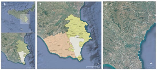
Figure 1.
Territorial framework of the municipality of Noto: (a) the province of Syracuse in the region of Sicily; (b) the municipalities in the provinces of Syracuse and Ragusa; (c) the territory of the municipality of Noto (our processing).
The excessive building production in the rural landscape has several reasons, including the shortcomings of the national legislation. In agricultural areas (defined as Zone—E), Italian Town Planning Legislation allows only developments that are functional to farming, including residential ones. However, this principle lacks detailed rules, except the definition of a maximum Floor Area Ratio (FAR) for residential buildings that allows approximately one dwelling per hectare.
In several cases, regional legislations, i.e., in Tuscany, have introduced more efficacious rules for regulating building activity in rural areas, but this is not the case in Sicily. There, Regional Law no. 71/1978 [57]—amended in 2002, repealed by Law no. 19/2020 [58] and reintroduced by Law no. 2 in 2021 [59]—loosens the limits on building in agricultural areas, triggering a process of progressive colonization of agricultural land. This process has taken place in the most evocative and uncontaminated rural areas, not sheltered by the protection measures that instead affect parks and reserves. Therefore, these areas are more exposed to landscape risk [60,61,62]. Regional law no. 71/1978 was originally intended as a tool for easing the development of agriculture by allowing the construction of the required facilities. However, its broad interpretation and several amendments have progressively allowed the sprawl of industrial buildings not related to agriculture, outside the planned industrial estates. The restriction to agricultural facilities was gradually repealed, even allowing commercial buildings or other activities funded by European and national funds.
The broad disciplinary field explored by this study is in trouble in terms of both its knowledge bases and the tools available for critical observation of the urbanization of rural areas. In fact, although this phenomenon has developed according to individual freedoms and within the limits of property rights, it has reached a vast scale, with redistributive effects of territorial wealth and significant impacts on landscape value [63].
Furthermore, the degree of almost total irreversibility of the building phenomenon, and moreover, attitudes to the obsolescence (physical, technological, functional, economic and typological) of building artifacts should discourage “tactical”—and thus, short-term—territorial policies, in favor of long-term strategies centered on resilient values that provide more support for the inertia than the dynamics of territories that are characterized by rarefied landscape connotations and are therefore easily attacked [64].
The concept of resilience, which has declined in the field of rural landscapes, is the convergence point of the cognitive and operational aspects of this study. Assuming that a landscape represents the shape of a territory, the persistence of it in the face of urban contamination is a factor that can be used to measure its resilience. This capacity can manifest as the aptitude of: maintaining recognizability even in the face of transformations incoherent with the original shape; metabolizing negative impacts by integrating them into the existing shape; and considering these transformations opportunities for the natural evolutionary course of the territorial identity.
According to the three dimensions of risk, “landscapes at risk” are affected by “landscape risk”, the hazard of significant changes in the socio-economic structure, triggering irreversible transformations of the most vulnerable components of the unitary and recognizable shapes of the most exposed (valuable) parts of the territory.
As a consequence, support for the agricultural sector should focus on the conservation of agrarian capital components related to resistant and structural landscape components—the shape of the rural territory—that characterize the uniqueness of the cultural mosaic, and the work forces engaged in it, rather than its real estate contamination [65,66], together with the work forces originating from outside.
According to the aforementioned relationship between assessment and planning, this study interprets this type of landscape risk with reference to the category of territorial capital as the underlying potential of resilient formal landscape units. Spatial planning is responsible for increasing the volume of social capital if the added value, in terms of collective service flows, is integrated in the increase in the landscape value stock [67,68,69,70,71,72,73,74,75,76,77,78,79,80].
In fact, the progressive shift in real estate [81,82] interest from dense urban contexts to the countryside has triggered a phenomenon whose control is based on the representation of the landscape, articulated in successive phases (observation, the construction of information and the evaluation of both the rural landscape and the building phenomenon), carried out on the basis of official databases using methods and tools for turning the data into information and the latter into evaluations [83].
Although the urbanization of rural and/or agricultural areas [84,85,86,87] has taken place in the agricultural territory of Noto in accordance with the regulations in force, the quality of the unconstrained areas has increased their locational advantage, leading to a form of “sprawl” [88,89,90,91,92,93,94,95,96,97,98,99,100] that results in uncontrolled urban expansion with low population density, except in coastal areas [101,102,103,104,105,106,107,108,109,110].
The case of Noto was approached by integrating the interfaces and the capabilities of a spreadsheet and a Geographic Information System (GIS) into a multidimensional analysis and evaluation model in order to organize the mass of available data through an organic and oriented set of queries, interpretations and correlations aimed at understanding and representing the way in which the rural landscape has undergone this drift [111,112,113,114,115,116].
This study is divided into six parts. Section 2 describes some of the characteristics of the agricultural territory of Noto with reference to the provincial- and municipal-scale planning instruments in force; Section 3 presents the method used to approach the representation of the value of the landscape risk due to the combination of the evolution of buildings and the characteristics of the agricultural landscape; Section 4 describes the procedure by which the model was applied and the results in terms of the overall assessment of the resilience of agricultural land affected by building expansion; Section 5 discusses the results, highlighting the limitations of the model, prospects for further research and the possibilities of extending the model; Section 6 outlines the main conclusions.
1.3. Rural Landscape
In 2000, the European Landscape Convention provided a clear and broad definition of a landscape: “Landscape means an area, as perceived by people, whose character is the result of the action and interaction of natural and/or human factors” [14].
UNESCO’s World Heritage Committee already agreed, in 1992, on revised operational guidelines specifying that cultural landscapes can be protected in accordance with the 1972 World Heritage Convention [117,118,119,120]. In 1995, the Committee of Ministers of the Council of Europe adopted the Recommendation on the Integrated Conservation of Cultural Landscape Areas as Part of Landscape Policies [121]. With reference to this, ICOMOS proposed the following definition: “rural landscapes are terrestrial and aquatic areas co-produced by human-nature interaction used for the production of food and other renewable natural resources, via agriculture, animal husbandry and pastoralism, fishing and aquaculture, forestry, wild food gathering, hunting, and extraction of other resources, such as salt [122]. Rural landscapes are multifunctional resources. At the same time, all rural areas have cultural meanings attributed to them by people and communities: all rural areas are landscapes” [122].
A rural landscape, in terms of heritage, includes the tangible and intangible heritage of rural areas. It “encompasses physical attributes (productive land itself, morphology, water, infrastructure, vegetation, settlements, rural buildings and centers, vernacular architecture, transport, and trade networks) and wider physical, cultural, and environmental linkages and settings” [122].
It also includes “associated cultural knowledge, traditions, practices, expressions of local human communities’ identity and belonging, and the cultural values and meanings attributed to those landscapes by past and contemporary people and communities” [122]. Rural landscape heritage encompasses technical, scientific, and practical knowledge related to human–nature relationships [123,124,125].
There are several definitions of rural landscapes in the literature, developed by authors of different disciplines, such as geography, landscape ecology, landscape aesthetics, rural tourism, social economics, and geographic information science.
In geography, the rural landscape is defined by some authors as: “a cultural landscape that transforms nature for agricultural purposes, rather than a natural landscape formed by geological, climatic and biological factors” [126,127]; as a landscape managed through local adaptation and historical traditional agricultural techniques, families and ways of life [128]; and as an area that is closely related to agriculture geographically and functionally [129].
In landscape ecology, Turner defined the rural landscape as a mosaic of a variety of landscape patches, providing species with a variety of broken spatial grid representations of living habitats, including grasslands, woodlands, arable land, roads and hedges [130]. Such an atomistic perspective has been integrated according to the different and somehow opposite perspective of landscape aesthetics, in which Antrop [131,132] defined the rural landscape as a collection of unique and identifiable structures that reflects a clear relationship between the constituent elements; these can be differently appreciated according multiple landscape experiences, which nowadays are mostly recreational, which cultural institutions try to drive toward low-impact practices. In fact, in rural tourism, van Zanten et al. [133] highlighted that the rural landscape offers a wide range of ecosystem services, such as recreation and tourism, connected to the aesthetic functions of cultural heritage.
As for the landscape’s material and immaterial streams, in landscape ecology, Zasada et al. [134] also recognize the rural material and immaterial landscapes services (LS) that directly or indirectly meet human needs, such as food production, pollination, water regulation and recreation. Again, in social economics, Schaller et al. [135] highlight that the rural landscape provides not only private types of goods, but also a wide range of public services, which cumulate, creating the socio-economic asset of the rural economy. Such a complex conceptual, cognitive and operational entity is a representation of of geographic information science; in this field, Statuto et al. [136,137] and Picuno et al. [112] highlight that the rural landscape, as a result of the interaction between natural components and human activities in time and space, is a non-renewable resource that provides information about the overall state of the environment [138].
In Italy, the failure to introduce a legal definition of the concept of a rural landscape, has resulted, over the years, in the progressive exploitation, without limits, of the rural landscape, as well as the depreciation of the dimension of the rural landscape [139]. The prospect of considering the rural landscape as a special category of cultural landscape could promote its protection. Article 142 of the Cultural Heritage and Landscape Code (24/02/2004) [140] lists a number of areas protected by law. They are identified as naturalistic areas, mountain areas, parks and nature reserves, forests and woodlands and other wetlands of geological or archaeological interest. For these areas, the legislature assumes the cultural value of the portion of land and subjects it to a series of constraints that its maintainers must comply with. Providing for the inclusion of rural landscapes of cultural and historical interest within these areas would promote their protection. In this regard, in Italy, the Ministry of Culture has launched calls in all regions for the restoration and enhancement of architecture and rural landscapes, supported by funding under the National Recovery and Resilience Plan: Mission 1—Investment 2.2: “Protection and Enhancement of Architecture and Rural Landscape” (05/05/2021) [141]. A total of EUR 590 million has been earmarked to support nearly 4000 projects that will receive funding in line with the objectives of protecting the cultural heritage and characteristic elements of rural landscapes: rural buildings, water- or windmills, oil mills, cheese factories, rural schools, barns, shelters, stables, dryers, ovens, troughs, bridges, and dry-stone walls.
2. Materials—The Territory of Noto and its Landscape Risk
The province of Syracuse occupies part of the Val di Noto, the eastern administrative district of the three into which the region was divided from the Muslim period (10th century AD) to 1812.
The municipality of Noto is the largest of the 21 into which the provincial territory is divided, occupying just over a quarter of the territory (550 sq.km out of 2124 sq.km).
The province has numerous nature areas and protected reserves of international importance, including Pantalica, Vendicari, the Maddalena Peninsula, the Ciane River and Saline di Siracusa Nature Reserve, and Capo Passero Island.
It is one of the most complex and densely populated areas in the whole of Sicily and, while until the last century it was a predominantly agricultural area, today, the entire province has become an industrial hub specializing in the chemical, electrical and engineering sectors, even though the primary sector remains alive through differentiated cultivation with various and numerous aspects of agricultural excellence.
The urban and planning instruments on various scales, and the studies on the territory of Noto analyzed to support this study, are:
- The Provincial Territorial Plan of Syracuse (21 December 2021) [142].
- The Territorial Landscape Plan of Syracuse (finally approved on 20 October 2017) [143].
- The “Noto Dossier” from the National Atlas of Rural Territory (2010) [144].
- The Masterplan of the Municipality of Noto (28 June 2018) [145,146,147], within which the following are relevant:
- The Implementation Rules;
- The Agricultural Forest Study.
2.1. Provincial Territorial Plan of Syracuse (PTPS)
The PTPS classifies the different areas of the provincial territory according to their vocation, according to the number of denominations (DOC, PDO and PGI) that fall within each of them: PGI—red orange from Sicily; PGI—lemon from Syracuse; PGI—tomato from Pachino; PDO—extra virgin olive oil from Frigintini, Trigona Pancali, Monte Lauro and Valle del Tellaro; and PDO—Moscato di Noto from Eloro.
From the overlapping of the various denomination areas (DOC, DOP and IGP), the provincial agricultural territory is classified into the following categories: Important Agricultural Areas, Agricultural Areas, and Ordinary Agricultural Areas.
The PTPS employs the original criterion of the Sicilian Regional Legislation, according to which municipal master plans may allocate land used for specialized crops, irrigated or equipped with infrastructure and facilities to support agricultural activity, and for non-agricultural uses only in exceptional cases.
2.2. Territorial Landscape Plan of Syracuse (TLPS)
The Landscape Plan of the areas falling within the province of Syracuse takes into account the landscape and environmental values of the territory through:
- -
- The analysis, protection and landscape enhancement of historical, natural and cultural resources;
- -
- Urban and building development in harmony with the different levels of recognized value.
The general objectives of the TLPS concern the ecological stabilization of the soil and the protection of biodiversity for reducing landscape risk in its multiple units and for its sustainable enhancement.
The main measures of the TLPS are generally aimed at the seven fundamental components of the agricultural landscape: herbaceous crops; arboreal crops; vineyards; citrus groves; crop mosaics; and greenhouse crops. In general, the measures include converting and improving the existing cover (except for greenhouse crops); creating renaturation areas and ecological networks; maintaining compatibility with the conservation of historical and landscape heritage, educational–recreational, ecological and testimonial functions and the variety of germplasms; maintaining and restoring traditional soil morphology (dry stone walls and terracing); maintaining plant functionality; restoring historical residences; and mitigating the landscape impact of existing greenhouse crops, especially in areas of greater landscape value [148,149,150].
2.3. National Atlas for Rural Territory
The National Atlas of Rural Territory, drafted by the Ministry of Agriculture, Food and Forestry Policies, is a support tool for rural development policies; it is aimed at investigating and interpreting the different geographies of rural development, using tools to assess the impact of agricultural policies on territories according to the European directives.
The Rural Atlas focuses on development processes within the local dimension by identifying 600 Local Systems within which it identifies the stock of fixed social capital present in the rural space, such as agricultural landscapes and urban resources, accessibility conditions and human resources.
The following local landscapes (LLs) fall within the territory of Noto:
- -
- LL 11: Tellaro River Valley;
- -
- LL 12: Hyblean Plateaus;
- -
- LL 13: Central Coastal Plain;
- -
- LL 14: Plateaus of Rosolini;
- -
- LL 15: Noto Clay Hills;
- -
- LL 16: Tellaro Floodplain;
- -
- LL 17: Lower Hyblean Mountains;
- -
- LL 18: Eloro Coast and Vendicari Marshes;
- -
- LL 19: Southern Marshes.
With reference to the subject of this study, Table 1 shows a summary of the salient features of the relationship between landscape values and the entity of urbanization of the territory, highlighted by the Atlas “Dossier Noto”.

Table 1.
Landscape risk drivers according to the National Rural Land Atlas (our processing).
3. Methods
3.1. Stages
This research crosses three distinguishable and integrated areas of investigation involved in research concerning the critical analysis and representation of the urbanization of rural territory: 1. assessment of the landscape values of the territorial context; 2. description of the urbanization of the rural territory; and 3. synthesis of the two findings, aimed at providing and mapping a landscape risk composite index.
The variety of data collected in the first two survey phases was reduced to comparable information units, sorted by subject and hierarchized by degree of depth. This made it possible to define appropriate evaluation indexes by correlating the results of cross-queries of the Regional Technical Cartography (RTC) [151] and the cadastre [152] databases: the former provided physical and quantitative data, and the latter qualitative and economic information. These phases, typically descriptive and evaluative, provide:
- A landscape assessment of the territorial context, assuming the 420 Cadastral Sheets (CS) as the minimum information land units;
- A critical representation of the phenomenon itself, in its extension and intensity, in space and time and with reference to the different units of information: the building units (BU), the land cadastral parcels (LCP) and the building cadastral parcels (BCP), available from the two above-mentioned sources.
- According to a land use planning prospect, the synthesis of the two above cognitive-valuative findings in terms of the assessment of landscape risk from building development.
The method was developed as follows:
- Creation of cartographic support for joint mapping of the territorial context and the buildings in three periods;
- Organization of the data relating to the different units of information;
- Characterization of the building dynamics in the rural territory;
- Identification and classification of the territorial units, distinguishing the main units (cadastral sheets and sub-sheets) designated for representation, and subordinate units (land cadaster parcels, building cadaster units, buildings in the Regional Technical Map) designated for characterization of the main units;
- Characterization of the main spatial units;
- Construction of the evaluation functions of the spatial unit;
- Construction of the evaluation functions of the building development phenomenon;
- Construction of indices for the overall assessment of the landscape resilience of each main territorial unit against the pressure of building dynamics.
3.2. Data Sources
The two main data sources used for the analyses of landscape context and building dynamics in the rural territory were, respectively, the Cadaster database of the Revenue Agency and the Regional Technical Cartography database supporting the Regional Territorial Information System.
3.2.1. Revenue Agency Database
The data used to represent the many dimensions of the landscape value of the territory of Noto were obtained from the land cadaster (LC) and building cadaster (BC) databases.
The census archive of the LC contains the technical, dimensional, legal and economic information of each cadastral parcel, from which we extracted data on identification, location, surface area, quality of cultivation or use, productivity class and yield.
The census archive of the BC contains dimensional, technical–physical, legal and economic information of each urban property unit (UP) from which we extracted the data on identification, location, type (A—residential and office use, B—public use, C—commercial use, D—industrial and special commercial use, E—collective use), size (number of rooms, surface or volume units depending on the type) and rent class (only for property units in types A, B and C).
3.2.2. Regional Geographic Information System
The representation of the regional territory was organized into four types of interrelated and continuously updated product: technical cartography, thematic cartography, the territorial information system and aero-photogrammetric surveys.
Technical cartography on a 1:10,000 scale was used to record the development of the building stock in the years 2000, 2007 and 2012 in the study area.
Information useful for identifying the evolution of the building stock was included in the vectorial layer “B” of Regional Technical Cartography. The height of the buildings was missing in this representation, so only the area and number of buildings could be reported.
3.3. The Model
3.3.1. Tools
The model developed for the assessment of landscape risk due to diffuse building in rural areas coordinates the functions of a spreadsheet (SpSh) and a Geographic Information System (GIS) to represent the value: 1. of the built stock, in terms of consistency and location; 2. of the landscape, in terms of the qualitative–quantitative value of the territorial units recognized as having attributes of landscape value; and 3. of the landscape risk derived from the landscape contextualization of the building phenomenon.
GIS is a tool designed for the storage, archiving and analysis of land objects and phenomena whose geographic location is the original and primary reference (Aronoff, 1989); it is used for both the spatial calculation and the representation of the consequent cognitive and evaluative dimensions [153,154].
By means of spatial join functions, the characteristics of the building stock dynamics were associated with the landscape qualities of the territorial units analyzed.
SpSh: Through the spreadsheet functions, we made the multiple value attributes of the information-bearing spatial units comparable, and created four interlinked databases:
- The main database consisted of land cadaster (LC) data referring to 410 cadaster sheets (CS, records) delimiting the basic value-bearer land units for the representation of landscape risk; the attributes (fields) were associated with these units by combining the functions of landscape value assessment and building stock evolution indices.
- The second included building cadaster (BC) data extracted for the 95,075 land cadaster parcels (LCPs) and building cadaster parcels (BCPs) of Noto.
- The third included 33,243 real estate properties (REPs) from the BC.
- The fourth included 15,146 building units (Bus) from the Technical Cartography.
3.3.2. Concepts
The evolution of the cognitive potential of spatial information technologies over the past 30 years has also significantly influenced the methods of analysis, evaluation and planning and their synthesis [155,156,157,158].
The explanatory functions of the method adopted here support the organization and control of the process of obtaining critical knowledge of the phenomenon in terms of its internal and external coherence. Internal coherence is an attribute of validity of the functions of the progressive abstraction of knowledge from the denotative to the connotative level, i.e., representation by the values [159,160,161,162] of landscape risk; external coherence is an attribute of the appropriateness of the “representation by value” to its reference, i.e., to the concrete forms of territorial capital in the evolution of its volume and value [163].
This cognitive path consists in the progressive abstraction of the concreteness of data into indices and evaluations, whereby throughout the hierarchic pattern, the denotation, signification, connotation and interpretation functions of the information units are organized at different levels of detail and according to their degree of involvement in the building development process.
In essence, landscape assessment is the representation of the territory by means of value attributes assigned to its elementary units, and is thus made comparable through “signification relations”, which refer to a value paradigm based on the category of territorial capital, and in its general dimension, social capital. Thus, the hierarchical collection and aggregation of information units, such as indices, measuring the multiple values of territorial units based on a unitary metric, are part of the additive utility approach of the Multi-Value Attribute Theory we refer to for the evaluation of both resilience and building pressure.
The latter performs both economic and symbolic functions [164], here represented through the interpretation of spatial information. The economic functions are measured with reference to the functional, productive and real estate characteristics of the different portions of the territory, and the symbolic ones with reference to the system of existing landscape constraints and the complexity of the cultivation mosaic [165].
3.3.3. Functions
The proposed model coordinates a hierarchical set of queries of the aforementioned databases to support the assessment of all landscape risk variables, individual and aggregated, according to two expressions (graphic and numerical) and referring to the territory and building dynamics, and their combination, in both factual and value terms.
Through the formation of specific indices, the ordered interpretation of landscape risk is represented in gradually more abstract form, and thus to a greater critical and evaluative degree. These representations converge in a final aggregate index that measures the resilience of the rural landscape, given by the impact that the driving forces of the building phenomenon exert on the value components of the rural landscape. This index is calculated via progressive reduction in the information spectrum, through which the two components (the building phenomenon and the rural landscape) are described and characterized through the ranks of denotation, connotation, and interpretation in which the different “Information Units” (IU) are placed (Figure 2).
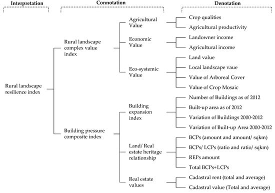
Figure 2.
Dendrogram of the IUs in the denotation, connotation, and interpretation processes. The denotation level of the dendrogram reports the specific criteria for the assessment of the whole Rural Landscape Resilience Index (our processing).
Denotation describes the landscape context and building phenomenon for the purpose of their evaluation and interpretive synthesis in terms of landscape risk.
- The landscape context, described and characterized with reference to the two databases:
- The territorial and regulatory database (in support of the urban planning instrumentation in force) regulates land function and use on the basis of the identification of the forms of territorial capital with regard to their capacity to deliver service flows without eroding this capacity over time; moreover, it indicates constraints, for example, on building, where this may interfere with the extent and quality of intangible (landscape) services that the areas included in the protection strategies primarily and permanently are able to provide.
- The real estate database, Land and Buildings Cadaster—LC and BC—which describes the territories and their purpose: “equalizing”, aimed at transferring part of the land and real estate added value to the public through the tax levy on the “privileges” of land and urban renting, and “informational”, in accordance with the civil functions of the cadaster, whose effectiveness is entrusted to the constant institutional updating process.
- The building phenomenon, also described and characterized with reference to two spatial and real estate databases:
- Regional Technical Cartography, where the consistency and location characteristics of the existing buildings are surveyed; the description includes regulatory references contained in current planning instruments regarding land use and constraints.
- The database of the BC, the register of cadastral parcels of farmland on which buildings of different types and functions exist, which, in turn, consist of real estate properties (REP), some of which are characterized by functional independence and autonomous yield capacity; the REP was assumed as the minimum study unit of the second database.
The general contents of denotation functions are summarized in the last column of Figure 2.
Connotation is the transformation of observations made at the denotation level into value attributes. The elementary IUs were normalized by means of specific valuation functions and converted into dimensionless scores for the application of an additive model. This allowed the territorial units (TUs) to be characterised with gradually more concise scores of landscape quality and building impact.
An additive multi-criteria evaluation model based on the Multi-Attribute Value Theory was used [166,167,168,169,170,171], whereby each territorial unit was assigned a value with reference to the generic evaluation criterion:
under the condition that
where is the evaluation of the landscape value or building pressure attributed to the territorial unit by the weighted sum of the related attributes, denoted as , in relation to the value attributes, whose relative importance with respect to the others of the same set is measured by the weighting factor .
The weighting factor system is the interface between assessments and spatial policy decisions, and as such, represents the perspectives of the stakeholders involved. It should be noted, in this regard, that this study has a methodological and exploratory cognitive perspective and proposes a useful tool for representing and measuring landscape risk on a large scale [172,173]. Accordingly, the weight system applied here was established on the basis of the authors’ expert knowledge, without any normative claim. In doing so, we outlined several hypotheses, choosing the one that best fits the shared knowledge of the area.
Interpretation is the synthesis of the results of the assessment, with the dual objective of combining, in a synthetic index, the connotations of the two risk components (landscape quality and building on agricultural land) and indicating the most significant correlations between the elements that constitute them.
The summary of the results is the degree to which the landscape value system is able to metabolize the impact of urbanization on the rural territory; this is the Landscape Resilience Value, calculated as the product of the Rural Landscape Complex Value Index and the Composite Building Pressure Index.
4. Application and Results
The Total Rural Landscape Resilience Value calculated for the 410 CFs is the result of the descriptive synthesis of 42 observations, the evaluation using 19 attributes, and the interpretation of the two indices measuring the Complex Rural Landscape Value and the Complex Building Pressure Value.
The following are the observation elements used for the subsequent rural landscape and building dynamics assessments with reference to the measures of agricultural value, economic value, and eco-socio-systemic value, respectively.
4.1. Denotations and Connotations
4.1.1. Rural Landscape
The valuations used for the structured connotation of the rural landscape are grouped into agricultural value, economic value and ecosystem value (Figure 2).
- Agricultural Value Index
This is an index of agricultural capital productivity and depends on the crop quality and land productivity class (from first (the best) to fifth (the worst)). Based on the queries of the LC census archive, the Agricultural Value Index is calculated as the average between the scores of the absolute value (in the whole CS) and the relative value (per area unit) of the weighted and normalized average productivity classes of all crop qualities: arable land, irrigated arable land, arboreal arable land, irrigated vegetable garden, vineyard, olive grove, orchard, irrigated orchard, citrus grove, irrigated citrus grove, cane grove, carob grove, almond grove, prickly pear, pasture, arboreal pasture, productive pasture, sterile pasture, ceded forest, tall forest, greenhouse, quarry, salt marsh and fish pond (Figure 3).
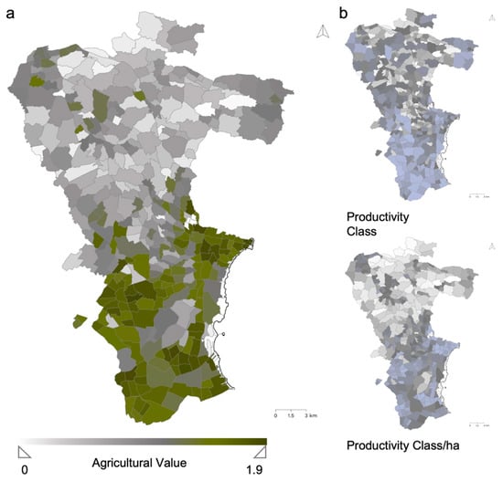
Figure 3.
Maps of agricultural value: (a) connotation; (b) denotations (our processing).
- Economic Value index
This is an index that aggregates: 1. the income streams of the value of agricultural capital, agricultural income and land capital, and dominical income, and 2. the conventional stock land value and the average agricultural value for each quality of crop. Again, the value is the average of the normalized absolute and relative measurements (Figure 4).
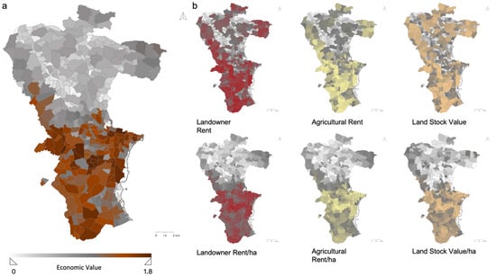
Figure 4.
Maps of economic value: (a) connotation; (b) denotations (our processing).
- Ecosystem value index
This index aggregates local landscape values represented by the presence of typical crops and tree cover and the complexity of the cultivation landscape. The assessment results in an extensive and complex analysis summarized by the sequence of 15 maps, ordered with respect to the prevalent crop in each CS (Figure 5).
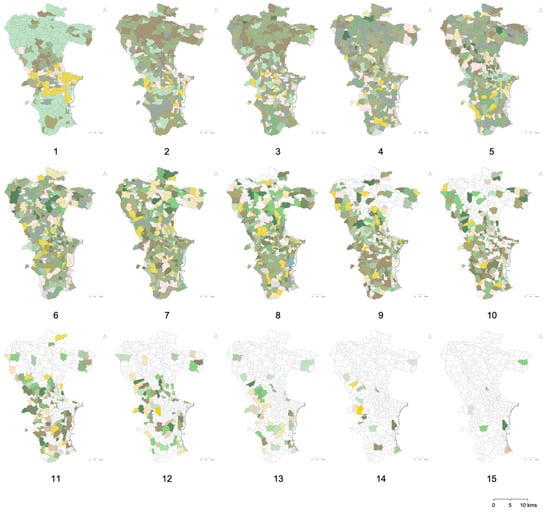
Figure 5.
Denotations: agricultural mosaics in 15 maps by culture prevalence in the cadastral sheets (our processing).
Again, the value is given by the average of the normalized absolute and relative magnitudes (Figure 6).
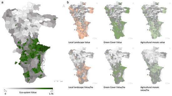
Figure 6.
Maps of ecosystem value: (a) connotation; (b) denotations (our processing).
4.1.2. Building Dynamics
The value representation of the phenomenon of building expansion in rural areas is based on the change in real estate volume (number of buildings and occupied area) and the real estate value of the built heritage with reference to the three observations in 2000, 2007 and 2012. Figure 7 displays the three stages of progressive evolution over the whole municipal territory.
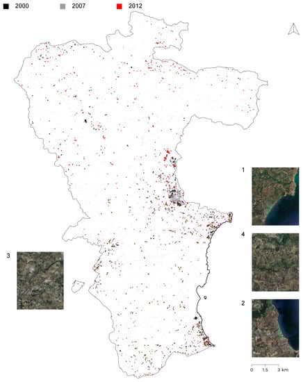
Figure 7.
Visualization of the phenomenon of building expansion in the territory of Noto in 2000, 2007 and 2012 (our processing).
Figure 8 focuses on four sample areas, two inland and two coastal.
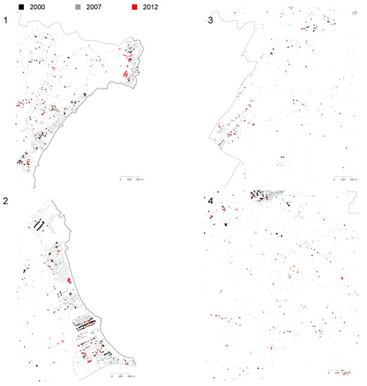
Figure 8.
Observation of the phenomenon of building expansion in the rural area of Noto in four of the most susceptible areas in 2000, 2007 and 2012 (our processing).
As a premise of the following assessments, these observations were mapped with reference to the intensity of the phenomenon, as variations from 2000 to 2007, from 2007 to 2012, and over the entire observation period (from 2000 to 2012), as well as variations in the number of BUs (Figure 9) and in the area occupied by buildings (Figure 10) in each CS.
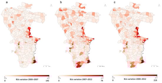
Figure 9.
Mapping of the variation in BUs over the period observed: (a) 2000–2007; (b) 2007–2012; (c) 2000–2012 (our processing).
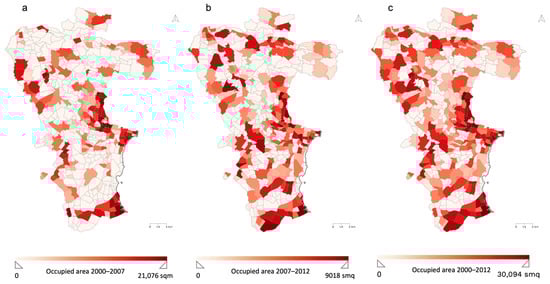
Figure 10.
Mapping of the variation in occupied area over the period observed: (a) 2000–2007; (b) 2007–2012; (c) 2000–2012 (our processing).
- Building development index
Based on the above surveys, building expansion was represented with reference to building stock and its variation between 2000 and 2012 in terms of BUs and area occupied, and in both absolute and relative values, that is, taking into account the number of BUs in each CF and the ratio of the latter to the area of the CF (Figure 11).
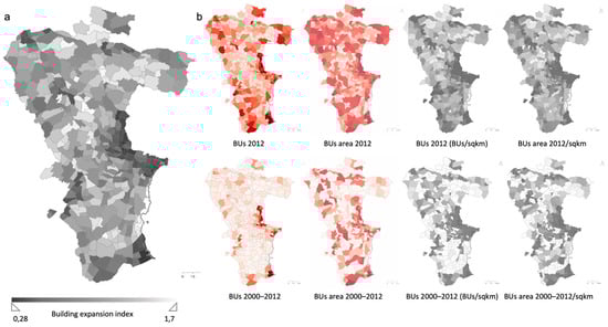
Figure 11.
Mapping of the building expansion Index: (a) connotation; (b) denotation (our processing).
- Index of the ratio of land and real estate assets
The index of the balance between the extent of land and real estate assets was calculated with reference to the size of the two land capital stocks—real estate and land—and with reference to the absolute and relative (per unit area) BCPs (the ratio of BCPs to LCPs in absolute terms and per unit area), with reference to the number of LCPs to total CPs, and the area of BUs in absolute terms and per unit area (Figure 12).
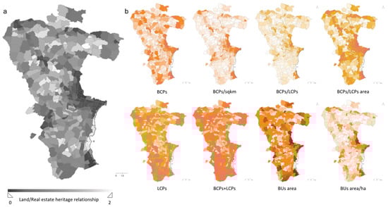
Figure 12.
Mapping of the land/real estate heritage relationship: (a) connotation; (b) denotation (our processing).
- Real estate value index
The property value was represented on the basis of cadastral income and the cadastral value, in both cases in absolute terms and per unit area (Figure 13); the cadastral value was obtained by multiplying the cadastral income by a coefficient established by the Internal Revenue Service for each cadastral category.
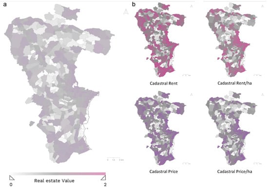
Figure 13.
Mapping of the real estate value index: (a) connotation; (b) denotation (our processing).
4.2. Interpretation
The last level of the evaluation pyramid concerns the interpretation functions. These were conducted by first completing context assessments, and then, phenomenon assessments, via calculation of the Rural Landscape Complex Value Index and the Building Pressure Composite Index, respectively (Figure 14).
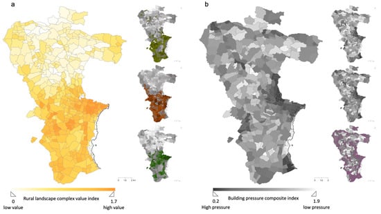
Figure 14.
Interpretations and connotations. Mapping of: (a) Rural Landscape Complex Value Index; (b) Building Pressure Composite Index (our processing).
Finally, at the top of the pyramid of this integrated landscape risk assessment in rural areas, the Rural Landscape Resilience Index was calculated as a synthesis of the overall qualities of the landscape context and the quantitative and qualitative characteristics of the building phenomenon, combining the two previous indices (Figure 15b). In Figure 15a, TUs in the yellow gradations represent areas where building pressure is low and landscape value is high, and vice versa for units in the grey gradations.
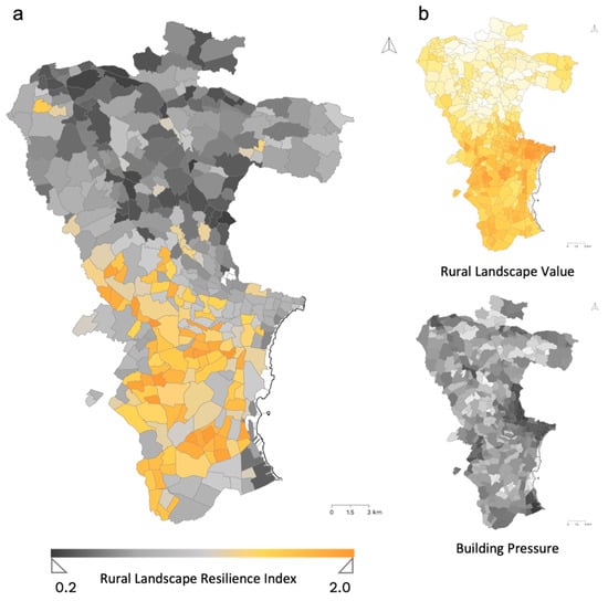
Figure 15.
Mapping of the Rural Landscape Resilience Index: (a) interpretation; (b) connotations (our processing).
The final results of the description and evaluation process developed so far are a test of the consistency and validity of the proposed model, the ultimate purpose of which is to target future land policies, starting with the amendment of the law that currently regulates building in rural areas [174,175,176,177,178,179,180,181,182].
The progressive reduction in the broad information into synthetic assessment units—according to the typical positive/normative approach characterizing the science of valuation—has provided a synoptic and convergent representation of the two components of landscape risk, rural land quality and the extension of building development [183,184].
The latter is concentrated in areas close to the beach area, northwest of the municipality of Noto, toward the wooded areas inland and along the stretch of SS 115 connecting the municipalities of Noto and Rosolini.
In the areas of Lido di Noto and San Lorenzo, where landscape values have not yet been compromised, recreational motivations prevail, which are expressed in the demand for vacation homes.
Particularly exposed to this risk are the buffer areas of the Vendicari Reserve—in the former case, facilitated by the almost total absence of constraints—which allow the expansion of pre-existing buildings.
In the northwest area, in the hamlet of San Corrado di Fuori, there has been a phenomenon that is not very different but somewhat less pronounced, which has also occurred along the SS 115; here, investments in the complementary receptivity sector have been implemented instead, with the transformation of old farmhouses in a state of abandonment, in contexts characterized by the prevalence of typical features of the rural landscape as opposed to naturalistic ones, and thus, where arable crops, citrus and olive groves predominate.
Figure 16 shows a combination of the observation of built development and the assessment of landscape values. In this representation, the differential impact that dense and diffuse building has on the resilience of the landscape context is more evident, even when of significant value.
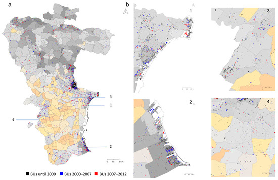
Figure 16.
Visualization of the phenomenon of building expansion in a resilience index map: (a) in the entire municipality; (b) in four of the most sensitive areas in 2000, 2007 and 2012 (our processing).
The last step in this representation concerns the correlation between the variation in some of the most significant drivers of landscape risk and the combination of the two components of the Landscape Resilience Index. Figure 17 shows, on the x-axis, the Complex Landscape Value Index, and on the y-axis, the Composite Building Pressure Index; each CS is represented by a bubble whose size represents the value of the drivers (the title of each graph) correlated with the joint variation of the two components.
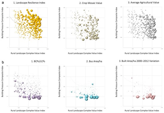
Figure 17.
Correlations between: (a) landscape value drivers and landscape resilience conjoint components; (b) building pressure drivers and landscape resilience conjoint components. The drivers are indicated in the title graphs and their values represented by the bubbles’ size (our processing).
5. Discussion
The results presented suggest several interpretations requiring specification and consolidation of the three main indices by homogeneous areas across the wide and articulated municipal landscape context of Noto.
In this experiment, further synthetic elaboration was carried out in order to discuss the general trends of the two main indices (supporting the calculation of the final one, the Landscape Resilience Index) from the perspective of some significant components: (a) the landscape value and (b) the pressure placed by building on rural territory.
These correlations are displayed by means of the graphs in Figure 17, reporting, on the x-axis, the Complex Landscape Value Index, and on the y-axis, the Composite Building Pressure Index; each territorial unit (CS) is represented by a bubble whose size represents the value of the drivers (the title of each graph) correlated with the joint variation of the two components.
Assuming the axis values as positive measures of appreciation, the generalized decreasing trend confirms that building pressure on land is most intense in areas of higher landscape value. This finding is assumed as the background of multiple possible correlations, including the following.
The graphs in (a) represent correlations related to the landscape context with reference to three of its most relevant dimensions: (a.1) overall resilience, (a.2) crop mosaic value and (a.3) agricultural value. As the two indices—the complex value in the abscissa, and the value of building pressure (taken as a positive value) in the ordinate—increase together:
- a.1
- Since the landscape resilience index (LRI) is calculated as a product of the other two, it increases proportionally along an ideal ‘growth path’ described by the vector exiting the origin of the axes, inclined by 45°; this is true from two complementary points of view, i.e., depending on the combination of the two indices (x and y). The territorial units at the top left and bottom right of the graph have approximately the same LRI, but the former denote low building pressure (appreciation is high) and a low landscape value, and vice versa.
- a.2
- The value of the crop mosaic grows more in line with the landscape value from the point of view of cultivation; this result denotes an understandable tendency for construction to focus on areas with the richest and most varied vegetation. Further investigation could also measure the hedonic price of the value of the crop mosaic, which can be taken as an aesthetic attribute.
- a.3
- Agricultural value is somewhat higher in the areas most affected by construction, consistent with the trend shown in a.2; this trend indicates the convergence of land and property rent.
The graphs in (b) display correlations related to building development with reference to three of the most relevant dimensions: (b.1) the cadastral stock, (b.2) the building volume and (b.3) the variation in building stock from 2000 to 2012. As the two indices increase together:
- b.1
- The property intensity, measured as the BCPs/LCPs ratio (building/land cadaster parcels), also increases as a function of landscape value; the level of attention in this index is important for providing some land policy elements inherent to the appropriateness of transferring land properties to the cadaster of buildings.
- b.2
- The BU area/ha increases according to the landscape value, as well; in this case, again, some landscape policy constraints should be triggered according to equalization tools, which can be used in order to discourage/encourage the worst/best building/landscape practices;
- b.3
- The building dynamics are more intense in the most valuable landscape areas, despite the real estate and economic–financial crisis that started in 2008, confirming the speculative expectations underlying rural landscape exploitation.
6. Conclusions
This contribution explored one of the most widespread aspects of landscape risk—building development in rural areas—through the observation of this phenomenon in the territory of the municipality of Noto, one of the most extensive in the Sicily region.
Through a hierarchical multidimensional analysis and evaluation model, based on the progressive abstraction of data into evaluations, the building phenomenon was represented in relation to landscape values regarding its territorial, economic–agricultural, economic–real estate and landscape components.
This research has shown to what extent and in what forms building development represents the primary driver of 1. economic–territorial imbalance and 2. landscape risk in areas typically characterised by a widespread landscape value, i.e., not depending on the presence of relevant landmarks but linked to the continuity and coherence between forms of production, working and living.
- The attempt by regional policy to address the issue of the intra-generational solidarity arising from territorial imbalance has triggered significant building pressure on the most valuable areas of the rural landscape, putting them at risk of irreversible transformation. The latter consists, in essence, of the progressive abstraction of agricultural value—linked to the concreteness of land work and land rent—into real estate value, transforming a socio-economic model centered on production into one inspired by speculation and treasure. This has led to the progressive prevalence of the recreational dimension (holiday homes), which reduces the rural component in the picturesque frame of “dissipative functions”, which are the exact opposite of the work activities that shaped this territory. The evolution of wealth distribution depends on changes in the origin and destination of added value. In the rural territory, wealth came from the primary sector, from work on the land, from the millennial evolution of widespread knowledge and from the transformation of surplus social product into the forms of the cultivated mosaic, and of a built heritage that consists of tension between natural, technological and economic constraints and the minimal needs of a life dedicated mainly to work in the fields. The current structural decline of the rural territory has disconnected the landscape value from agricultural production, leading to the emergence of the manufacturing, construction, and tertiary sectors (particularly marketing, accommodation, catering and personal services). A radical change in the legislation regarding the extent of the rural area that can be used for production and residential buildings is needed.
- The main sustainability issues concerning inter-generational solidarity are derived from the irreversibility of new buildings and the underlying property rights. The obsolescence of hasty construction, driven by purposes unrelated to the land and its original economic value, represents a profound and permanent modification of this territory and the very essence of its landscape. The resulting territorial scenario thus backfires against the very purpose of the legal framework, which, with the intention of supporting agricultural activity, facilitates building in rural areas; thus, it ends up supporting the real estate sector, which irreversibly impoverishes the territory from a physical–agronomic and cultural point of view. Finally, interpreting this phenomenon in the light of the fundamental dualities between wealth and value and between stock and stream magnitudes, the inversion of causal relationships can be outlined as follows: Agricultural activity has always provided sufficient economic energy to build and maintain towns, infrastructure, rural villages and agricultural complexes; consequently, tthe accumulation of wealth in the shapes of the durable capital has had in agricultural activity its origin, and in its surplus, its destination. Finally, the prospect of fostering agricultural production with a legislative measure that expands building activity reverses the traditional perspective by implying that the production of added value no longer creates capital but, rather, real estate speculation creates added value in terms of capital gains. Additionally, against the background of the new prospects of global climate change, outlined by the pandemic and military crises, rural landscape exploitation for short-term added value creation reflects an inadequate land economics vision that rejects the main and only possible approach to the ecological transition, the recovery of lifestyle moderation and the preservation of resource stock with a high information value cumulation.
This study shows that a radical change in current regional legislation is needed in order to clarify that agricultural land requires a higher level of protection than is currently provided. The study presented herein has the aim of improving the knowledge needed to support the required legislative change with data [185]. Further development could include the issues of hydrological hazards and landscape fragmentation, both relevant in the studied area. Finally, the proposed model, based on the abstraction of occurrences, is projected to be used on a municipal scale in all the municipalities of the province and region; furthermore, it allows us to aggregate the results at the level of the municipality for further critical analyses and assessments on a provincial and regional scale [186].
Author Contributions
Conceptualization, F.M., M.R.T. and S.G.; methodology, C.M., M.R.T. and S.G.; software, C.M., F.M., M.R.T. and S.G.; validation, C.M. and M.R.T.; formal analysis, M.R.T. and S.G.; investigation, C.M.; resources, C.M. and F.M.; data curation, C.M., M.R.T. and S.G.; writing—original draft preparation, C.M., M.R.T. and S.G.; writing—review and editing, M.R.T. and S.G.; visualization, C.M. and M.R.T.; supervision, F.M., M.R.T. and S.G.; project administration, M.R.T. and S.G.; funding acquisition, M.R.T. and S.G. All authors have read and agreed to the published version of the manuscript.
Funding
This work was financed by the University of Catania’s project entitled “Architettura a Rischio: Demolire, Recuperare, Restaurare. Il tema della qualità nel progetto sul patrimonio—ARDeRe, scientific responsible De Medici S.”, which is part of the general project “Piano della Ricerca Dipartimentale 2020–2022 of the Department of Civil Engineering and Architecture”.
Data Availability Statement
Not applicable.
Conflicts of Interest
The authors declare no conflict of interest.
References
- Giuffrida, S.; Gagliano, F.; Giannitrapani, E.; Marisca, C.; Napoli, G.; Trovato, M.R. Promoting Research and Landscape Experience in the Management of the Archaeological Networks. A Project-Valuation Experiment in Italy. Sustainability 2020, 12, 4022. [Google Scholar] [CrossRef]
- La Greca, P.; Martinico, F. Energy and Spatial Planning: A Smart Integrated Approach. In Smart Energy in the Smart City; Papa, R., Fistola, R., Eds.; Springer International Publishing: Basel, Switzerland, 2016; pp. 43–61. ISBN 978-331930203-4. [Google Scholar] [CrossRef]
- Trovato, M.R. Human Capital Approach in the Economic Assessment of Interventions for the Reduction of Seismic Vulnerability in Historic Centres. Sustainability 2020, 12, 8059. [Google Scholar] [CrossRef]
- Irwin, E.G.; Bockstael, N.E. Land use externalities, open space preservation, and urban sprawl. Reg. Sci. Urban Econ. 2004, 34, 705–725. [Google Scholar] [CrossRef]
- Martinuzzi, S.; Gould, W.A.; González, O.M.R. Land development, land use, and urban sprawl in Puerto Rico integrating remote sensing and population census data. Landsc. Urban Plan. 2007, 79, 288–297. [Google Scholar] [CrossRef]
- Cerreta, M.; De Toro, P. Urbanization suitability maps: A dynamic spatial decision support system for sustainable land use. Earth Syst. Dyn. 2012, 3, 157–171. [Google Scholar] [CrossRef]
- Torrieri, F.; Oppio, A.; Mattia, S. The Sustainable Management of Flood-Risk Areas: Criticisms and Future Research Perspectives. In Seminar of the Italian Society of Property Evaluation and Investment Decision; Springer: Cham, Switzerland, 2016; pp. 559–568. [Google Scholar]
- Dell’Ovo, M.; Torrieri, F.; Oppio, A. How to model stakeholder participation for flood management. In International Conference on Decision Support System Technology; Springer: Cham, Switzerland, 2018; pp. 67–75. [Google Scholar]
- Della Spina, L.; Giorno, C.; Casmiro, R.G. An Integrated Decision Support System to Define the Best Scenario for the Adaptive Sustainable Re-Use of Cultural Heritage in Southern Italy. In New Metropolitan Perspectives. NMP 2020. Smart Innovation, Systems and Technologies; Bevilacqua, C., Calabrò, F., Della Spina, L., Eds.; Springer: Cham, Switzerland, 2020; Volume 177. [Google Scholar] [CrossRef]
- Della Spina, L.; Rugolo, A. A Multicriteria Decision Aid Process for Urban Regeneration Process of Abandoned Industrial Areas. In New Metropolitan Perspectives. NMP 2020. Smart Innovation, Systems and Technologies; Bevilacqua, C., Calabrò, F., Della Spina, L., Eds.; Springer: Cham, Switzerland, 2021; Volume 178. [Google Scholar] [CrossRef]
- Della Spina, L. Strategic Planning and Decision Making: A Case Study for the Integrated Management of Cultural Heritage Assets in Southern Italy. In New Metropolitan Perspectives. NMP 2020. Smart Innovation, Systems and Technologies; Bevilacqua, C., Calabrò, F., Della Spina, L., Eds.; Springer: Cham, Switzerland, 2021; Volume 178. [Google Scholar] [CrossRef]
- Coscia, C.; Rubino, I. LA creazione di nuovi valori nei processi di rigenerazione urbana e periurbana: La risposta social impact-oriented della disciplina della valutazione economica die progetti. LaborEst 2021, 22, 50–56. [Google Scholar]
- Giuffrida, S. The True Value. On Understanding Something. In Appraisal: From Theory to Practice. Green Energy and Technology; Stanghellini, S., Morano, P., Bottero, M., Oppio, A., Eds.; Springer: Cham, Switzerland, 2017; pp. 1–14. [Google Scholar] [CrossRef]
- Council of Europe. European Landscape Convention; Council of Europe: Florence, Italy, 2000. [Google Scholar]
- Han, J.; Hayashi, Y.; Cao, X.; Imura, H. Evaluating Land-Use Change in Rapidly Urbanizing China: Case Study of Shanghai. J. Urban Plan. Dev. 2009, 135, 166–171. [Google Scholar] [CrossRef]
- Huang, J.; Lu, X.X.; Sellers, J.M. A global comparative analysis of urban form: Applying spatial metrics and remote sensing. Landsc. Urban Plan. 2007, 82, 184–197. [Google Scholar] [CrossRef]
- DiBari, J.N. Evaluation of five landscape-level metrics for measuring the effects of urbanization on landscape structure: The case of Tucson, Arizona, USA. Landsc. Urban Plan. 2007, 79, 308–313. [Google Scholar] [CrossRef]
- Dong, Q.; Qu, S.; Qin, J.; Yi, D.; Liu, Y.; Zhang, J. A Method to Identify Urban Fringe Area Based on the Industry Density of POI. ISPRS Int. J. Geo-Inf. 2022, 11, 128. [Google Scholar] [CrossRef]
- Garau, C.; Pavan, V.M. Evaluating Urban Quality: Indicators and Assessment Tools for Smart Sustainable Cities. Sustainability 2018, 10, 575. [Google Scholar] [CrossRef]
- Peeling, J.A.; Singh, A.; Judge, J. A Structural Equation Modeling Approach to Disentangling Regional-Scale Landscape Dynamics in Ghana. Front. Environ. Sci. 2022, 9, 668. [Google Scholar] [CrossRef]
- Sas-bojarska, A. Landscape as a potential key concept in urban environmental planning: The case of Poland. Urban Plan. 2021, 6, 295–305. [Google Scholar] [CrossRef]
- Hargis, C.D.; Bissonette, J.A.; David, J.L. The behavior of landscape metrics commonly used in the study of habitat fragmentation. Landsc. Ecol. 1998, 13, 167–186. [Google Scholar] [CrossRef]
- Hulshoff, R.M. Landscape indices describing a Dutch landscape. Landsc. Ecol. 1995, 10, 101–111. [Google Scholar] [CrossRef]
- Jantz, C.A.; Goetz, S.J. Analysis of scale dependencies in an urban land-use-change model. Int. J. Geogr. Inf. Sci. 2005, 19, 217–241. [Google Scholar] [CrossRef]
- Wu, F. Calibration of stochastic cellular automata: The application to rural-urban land conversions. Int. J. Geogr. Inf. Sci. 2002, 16, 795–818. [Google Scholar] [CrossRef]
- Woods, M. Rural geography: Blurring boundaries and making connections. Prog. Hum. Geogr. 2009, 33, 849–858. [Google Scholar] [CrossRef]
- Paquette, S.; Domon, G. Changing ruralities, changing landscapes: Exploring social recomposition using a multi-scale approach. J. Rural. Stud. 2003, 19, 425–444. [Google Scholar] [CrossRef]
- Schwarz, N. Urban form revisited—Selecting indicators for characterising European cities. Landsc. Urban Plan. 2010, 96, 29–47. [Google Scholar] [CrossRef]
- Davoudi, S.; Stead, D. Urban-rural relationships: An introduction and a brief history. Built Environ. 2022, 28, 269–277. [Google Scholar]
- Dymitrow, M.; Stenseke, M. Rural-urban blurring and the subjectivity within. Rural Landsc. Soc. Environ. Hist. 2016, 3, 4. [Google Scholar] [CrossRef]
- Briggs, D.J.; France, J. Landscape evaluation: A comparative study (South Yorkshire, UK). J. Environ. Manag. 1980, 10, 263–275. [Google Scholar]
- Dearden, P. Focus: Landscape aesthetics. Can. Geogr./Le Géographe Canadien. 1985, 29, 263–265. [Google Scholar] [CrossRef]
- Shuttleworth, S. The evaluation of landscape quality. Landsc. Res. 1979, 5, 14–15. [Google Scholar] [CrossRef]
- Trovato, M.R.; Micalizzi, P.; Giuffrida, S. Assessment of Landscape Co-Benefits in Natura 2000 Site Management Plans. Sustainability 2021, 13, 5707. [Google Scholar] [CrossRef]
- Antrop, M. Why landscapes of the past are important for the future. Landsc. Urban Plan. 2005, 70, 21–34. [Google Scholar] [CrossRef]
- Frontuto, V.; Corsi, A.; Novelli, S.; Gullino, P.; Larcher, F. The visual impact of agricultural sheds on rural landscapes: The willingness to pay for mitigation solutions and treatment effects. Land Use Policy 2020, 91, 104337. [Google Scholar] [CrossRef]
- Giuffrida, S.; Trovato, M.R.; Circo, C.; Ventura, V.; Giuffrè, M.; Macca, V. Seismic Vulnerability and Old Towns. A Cost-Based Programming Model. Geosciences 2019, 9, 427. [Google Scholar] [CrossRef]
- Kiran, G.S.; Joshi, U.B. Estimation of variables explaining urbanization concomitant with land-use change: A spatial approach. Int. J. Remote Sens. 2013, 34, 824–847. [Google Scholar] [CrossRef]
- Gerundo, R.; Grimaldi, M. The Measure of Land Consumption Caused by Urban Planning. Procedia Eng. 2011, 21, 1152–1160. [Google Scholar] [CrossRef]
- Giuffrida, S.; Carocci, C.; Circo, C.; Trovato, M.R. Axiological Strategies in the Old Towns Seismic Vulnerability Mitigation Planning. Valori Valutazioni 2020, 25, 99–106. [Google Scholar]
- Bryant, C.R.; Russwurm, L.H.; McLellan, A.G. The City’s Countryside: Land and Its Management in the Rural-Urban Fringe; Longman: London, UK, 1982; ISBN 0582300452/978-058230045-3. [Google Scholar]
- Bajracharya, B.N.; Hastings, P. A Regional, Strategic Growth-Management Approach to Urban and Peri-Urban Development in South East Queensland, Australia. J. Reg. City Plan. 2018, 29, 210. [Google Scholar] [CrossRef]
- Giuffrida, S.; Trovato, M.R. From the Object to Land. Architectural Design and Economic Valuation in the Multiple Dimensions of the Industrial Estates. In Computational Science and Its Applications–ICCSA 2017, Proceedings of the 17th International Conference, Trieste, Italy, 3–6 July 2017; Springer International Publishing: Cham, Germany, 2017; pp. 591–606. [Google Scholar]
- Anelli, D.; Tajani, F.; Ranieri, R. Urban resilience against natural disasters: Mapping the risk with an innovative indicators-based assessment approach. J. Clean. Prod. 2022, 371, 133496. [Google Scholar] [CrossRef]
- Camagni, R. Processi di Utilizzazione e Difesa dei Suoli Nelle Fasce Periurbane: Dal Conflitto alla Cooperazione; Fondazione Cariplo per la Ricerca Scientifica: Milano, Italy, 1994. [Google Scholar]
- Rete Rurale Nazionale, Ministero delle Politiche Agricole, Alimentari, Forestali e del Turismo. Atlante Nazionale del Territorio Rurale. Rete Rurale Nazionale; Ministero delle Politiche Agricole, Alimentari, Forestali e del Turismo: Rome, Italy, 2010. [Google Scholar]
- ISPRA. Consumo di Suolo, Dinamiche Territoriali e Servizi Ecosistemici; ISPRA: Rome, Italy, 2020. Available online: https://www.isprambiente.gov.it/it/banche-dati (accessed on 2 March 2023).
- ISTAT. Forme, Livelli, Dinamiche Dell′Urbanizzazione in Italia; ISTAT: Roma, Italy, 2017. [Google Scholar]
- van Vliet, J.; Verburg, P.H.; Grădinaru, S.R.; Hersperger, A.M. Beyond the urban-rural dichotomy: Towards a more nuanced analysis of changes in built-up land. Comput. Environ. Urban Syst. 2018, 74, 41–49. [Google Scholar] [CrossRef]
- Butt, A.; Fish, B. Amenity, Landscape and Forms of Peri-Urbanisation Around Melbourne, Australia. In Conflict and Change in Australia’s Peri-Urban Landscape; Kennedy, M., Butt, A., Amati, M., Eds.; Routledge: New York, NY, USA; Oxon, UK, 2016; pp. 7–27. [Google Scholar]
- Allen, A. Environmental planning and management of the peri-urban interface: Perspectives on an emerging field. Environ. Urban. 2003, 15, 135–148. [Google Scholar] [CrossRef]
- Benni, S.; Minarelli, F.; Paolinelli, G.; Torreggiani, D.; Tassinari, P. Lettura ed interpretazione dei caratteri dello spazio periurbano. Agribus. Paesaggio Ambiente 2008, 11, 150–158. [Google Scholar]
- Elmqvist, T. Urban Resilience Thinking. Solut. J. 2014, 5, 26–30. [Google Scholar]
- Folke, C. Resilience. In Oxford Research Encyclopedia of Environmental Science; Oxford University Press: Oxford, UK, 2016; pp. 1–63. [Google Scholar] [CrossRef]
- Plieninger, T.; Bieling, C. Connecting cultural landscapes to resilience. In Resilience and the Cultural Landscape: Understanding and Managing Change in Human-Shaped Environments; Plieninger, T., Bieling, C., Eds.; Cambridge University Press: Cambridge, UK, 2012; pp. 3–26. [Google Scholar] [CrossRef]
- Voghera, A. Resilience Through Community Landscape Project. In Proceedings of the UNISCAPE En-Route International Seminar, Ascoli-Piceno, Ascoli-Piceno, Italy, 13–14 April 2015; pp. 103–108. [Google Scholar]
- Sicilian Region. Regional Law 27 December 1978, No. 71 (1). Norme Integrative e Modificative della Legislazione Vigente nel Territorio Della Regione Siciliana in Materia Urbanistica, Palermo. 1978. Available online: https://osservatorio.urbanit.it/wp-content/uploads/2016/06/SICILIA_LR-71_1978.pdf (accessed on 2 March 2023).
- Sicilian Region. Regional Law 13 August 2020, no. 19. Norms for the Goverment of the Territory. Palermo. 2020. Available online: https://w3.ars.sicilia.it/lex/L_2020_019.htm (accessed on 2 March 2023).
- Sicilian Region. Regional Law 3 February 2020, no. 2. Corrective Action to the Regional Law 13 August 2020, n.19 Bearing Norms on the Government of the Territory. Palermo. 2021. Available online: https://w3.ars.sicilia.it/lex/L_2021_002.htm (accessed on 2 March 2023).
- La Rosa, D.; Martinico, F. Assessment of hazards and risks for landscape protection planning in Sicily. J. Environ. Manag. 2013, 127, S155–S167. [Google Scholar] [CrossRef]
- Longo, A.; Martinico, F. The Protection of Agricultural Areas and Urban Legislation. Reflections on Building Uses of Rural Soils; Documenti Geografici: Rome, Germany, 2019; pp. 87–100. ISSN 2281-7549. [Google Scholar] [CrossRef]
- Trovato, M.R.; Giuffrida, S. The Protection of Territory from the Perspective of the Intergenerational Equity. In Green Energy and Technology; Springer: Berlin/Heidelberg, Germany, 2018; Volume Part F8, pp. 469–485. [Google Scholar] [CrossRef]
- Trovato, M.R.; Giuffrida, S.; Collesano, G.; Nasca, L.; Gagliano, F. People, Property and Territory: Valuation Perspectives and Economic Prospects for the Trazzera Regional Property Reuse in Sicily. Land 2023, 12, 789. [Google Scholar] [CrossRef]
- Gordon, A.; Simondson, D.; White, M.; Moilanen, A.; Bekessy, S.A. Integrating conservation planning and landuse planning in urban landscapes. Landsc. Urban Plan. 2009, 91, 183–194. [Google Scholar] [CrossRef]
- Gabrielli, L.; Giuffrida, S.; Trovato, M.R. From Surface to Core: A Multi-Layer Approach for the Real Estate Market Analysis of a Central Area in Catania. In Proceedings of the Computational Science and Its Applications—ICCSA 2015, Banff, AB, Canada, 22–25 June 2015; Gervasi, O., Murgante, B., Misra, S., Gavrilova, M.L., Rocha, A.M.A.C., Torre, C., Taniar, D., Apduhan, B.O., Eds.; Springer International Publishing: Cham, Switzerland, 2015; pp. 284–300. [Google Scholar]
- Gabrielli, L.; Giuffrida, S.; Trovato, M.R. Functions and Perspectives of Public Real Estate in the Urban Policies: The Sustainable Development Plan of Syracuse. In Proceedings of the Computational Science and Its Applications—ICCSA 2016, Santander, Spain, 20–23 June 2011; Gervasi, O., Murgante, B., Misra, S., Rocha, A.M.A.C., Torre, C.M., Taniar, D., Apduhan, B.O., Stankova, E., Wang, S., Eds.; Springer International Publishing: Cham, Switzerland, 2016; pp. 13–28. [Google Scholar]
- Brunetta, G.; Caldarice, O. Spatial Resilience in Planning: Meanings, Challenges, and Perspectives for Urban Transition. In Sustainable Cities and Communities, Encyclopedia of the UN Sustainable Development Goals; Filho, W.L., Azul, A.M., Brandli, L., Gökçin Özuyar, P., Wall, T., Eds.; Springer Nature Switzerland AG: Basel, Switzerland, 2019; pp. 1–12. [Google Scholar] [CrossRef]
- Giuffrida, S.; Casamassima, G.; Trovato, M.R. Le norme EMAS-ISO nella valutazione della qualità del servizio idrico integrato. Aestimum 2017, 70, 109–134. [Google Scholar] [CrossRef]
- Brunetta, G.; Ceravolo, R.; Barbieri, C.A.; Borghini, A.; de Carlo, F.; Mela, A.; Beltramo, S.; Longhi, A.; De Lucia, G.; Ferraris, S.; et al. Territorial Resilience: Toward a Proactive Meaning for Spatial Planning. Sustainability 2019, 11, 2286. [Google Scholar] [CrossRef]
- Butler, A.; Knez, I.; Åkerskog, A.; Herlin, I.S.; Sang, O.; Ångman, E. Foraging for identity: The relationships between landscape activities and landscape identity after catastrophic landscape change. Landsc. Res. 2019, 44, 303–319. [Google Scholar] [CrossRef]
- Folke, C.; Carpenter, S.R.; Walker, B.; Scheffer, M.; Chapin, T.; Rockström, J. Resilience Thinking: Integrating Resilience, Adaptability and Transformability. Ecol. Soc. 2010, 15, 20. [Google Scholar] [CrossRef]
- Fröhlich, K.; Hassink, R. Regional resilience: A stretched concept? Eur. Plan. Stud. 2018, 26, 1763–1778. [Google Scholar] [CrossRef]
- Zebrowski, C. The nature of resilience. Resilience 2013, 1, 159–173. [Google Scholar] [CrossRef]
- Cattivelli, V. Institutional Methods for the Identification of Urban and Rural Areas—A Review for Italy. In Smart and Sustainable Planning for Cities and Regions. SSPCR 2019; Bisello, A., Vettorato, D., Ludlow, D., Baranzelli, C., Eds.; Green Energy and Technology; Springer: Cham, Switzerland, 2021; pp. 187–207. [Google Scholar] [CrossRef]
- Trovato, M.R. An Axiology of Residual Green Urban Areas. Environments 2021, 8, 53. [Google Scholar] [CrossRef]
- Champion, T. Urbanization, suburbanisation, counterurbanisation and reurbanisation. In Handbook of Urban Studies; Paddison, R., Ed.; Sage: London, UK, 2001; pp. 143–161. [Google Scholar]
- EEA. Mapping Europe’s Environmental Future: Understanding the Impacts of Global Megatrends at the National Level; Report n.2/2017; EEA: Copehnagen, Denmark, 2017. [Google Scholar]
- Hersperger, A.M.; Oliveira, E.; Pagliarin, S.; Palka, G.; Verburg, P.; Bolliger, J.; Grădinaru, S. Urban land-use change: The role of strategic spatial planning. Glob. Environ. Chang. 2018, 51, 32–42. [Google Scholar] [CrossRef]
- La Rosa, D.; Geneletti, D.; Spyra, M.; Albert, C.; Fürst, C. Sustainable Planning for Peri-urban Landscapes. In Ecosystem Services from Forest Landscapes: Broadscale Considerations; Springer: Berlin/Heidelberg, Germany, 2018; pp. 89–126. [Google Scholar] [CrossRef]
- Qviström, M.; Saltzman, K. Ambiguous edgelands: Landscape studies beyond rural–urban divides and disciplinary trench-lines. Urban For. Urban Green. 2008, 7, 143–144. [Google Scholar] [CrossRef]
- Gabrielli, L.; Giuffrida, S.; Trovato, M.R. Gaps and Overlaps of Urban Housing Sub-market: Hard Clustering and Fuzzy Clustering Approaches. In Appraisal: From Theory to Practice; Springer: Cham, Switzerland, 2017; pp. 203–219. [Google Scholar] [CrossRef]
- Trovato, M.R.; Clienti, C.; Giuffrida, S. People and the City: Urban Fragility and the Real Estate-Scape in a Neighborhood of Catania, Italy. Sustainability 2020, 12, 5409. [Google Scholar] [CrossRef]
- Giuffrida, S.; Trovato, M.R. A Semiotic Approach to the Landscape Accounting and Assessment. An Application to the Urban-Coastal Areas. In Proceedings of the 8th International Conference on Information and Communication Technologies in Agriculture, Food and Environment, HAICTA 2017, Chania, Greece, 21–24 September 2017; Salampasis, M., Theodoridis, A., Bournaris, T., Eds.; CEUR Workshop Proceedings: Aachen, Germany, 2017; pp. 696–708, ISSN 16130073. [Google Scholar]
- Basso, M.; Vettoretto, L. Reversal sprawl. Land-use regulation, society and institutions in Proseccotown. Land Use Policy 2020, 99, 105016. [Google Scholar] [CrossRef]
- Moroni, S.; Minola, L. Unnatural sprawl: Reconsidering public responsibility for suburban development in Italy, and the desirability and possibility of changing the rules of the game. Land Use Policy 2019, 86, 104–112. [Google Scholar] [CrossRef]
- OECD. Redefining “Urban”: A New Way to Measure Metropolitan Areas; OECD: Paris, France, 2013. [Google Scholar]
- OECD. Rethinking Urban Sprawl: Moving towards Sustainable Cities; OECD: Paris, France, 2018. [Google Scholar]
- La Greca, P.; La Rosa, D.; Martinico, F.; Nigrelli, F.C. Landscape and sprawl. studies and proposals for the landscape protection plan in Sicily. In Archivio di Studi urbani e Regionali; FrancoAngeli: Milano, Italic, 2014; pp. 96–118. [Google Scholar] [CrossRef]
- Jacquin, A.; Misakova, L.; Gay, M. A hybrid object-based classification approach for mapping urban sprawl in periurban environment. Landsc. Urban Plan. 2008, 84, 152–165. [Google Scholar] [CrossRef]
- Feng, L.; Li, H. Spatial Pattern Analysis of Urban Sprawl: Case Study of Jiangning, Nanjing, China. J. Urban Plan. Dev. 2012, 138, 263–269. [Google Scholar] [CrossRef]
- Jaeger, J.A.; Bertiller, R.; Schwick, C.; Cavens, D.; Kienast, F. Urban permeation of landscapes and sprawl per capita: New measures of urban sprawl. Ecol. Indic. 2010, 10, 427–441. [Google Scholar] [CrossRef]
- Bürgi, M.; Hersperger, A.M.; Schneeberger, N. Driving forces of landscape change—Current and new directions. Landsc. Ecol. 2005, 19, 857–868. [Google Scholar] [CrossRef]
- Helming, K.; Perez-Soba, M.; Tabbush, P. (Eds.) Sustainability Impact Assessment of Land Use Changes; Springer: Berlin/Heidelberg, Germany, 2008. [Google Scholar]
- Liu, Y.S. Introduction to land use and rural sustainability in China. Land Use Policy 2018, 74, 1–4. [Google Scholar] [CrossRef]
- Sumari, N.S.; Cobbinah, P.B.; Ujoh, F.; Xu, G. On the absurdity of rapid urbanization: Spatio-temporal analysis of land-use changes in Morogoro, Tanzania. Cities 2020, 107, 102876. [Google Scholar] [CrossRef]
- Cattivelli, V. Planning peri-urban areas at regional level: The experience of Lombardy and Emilia-Romagna (Italy). Land Use Policy 2021, 103, 105282. [Google Scholar] [CrossRef]
- Herold, M.; Scepan, J.; Clarke, K.C. The Use of Remote Sensing and Landscape Metrics to Describe Structures and Changes in Urban Land Uses. Environ. Plan. A Econ. Space 2002, 34, 1443–1458. [Google Scholar] [CrossRef]
- Aguilera, F.; Valenzuela, L.M.; Botequilha-Leitão, A. Landscape metrics in the analysis of urban land use patterns: A case study in a Spanish metropolitan area. Landsc. Urban Plan. 2011, 99, 226–238. [Google Scholar] [CrossRef]
- Deng, J.S.; Wang, K.; Hong, Y.; Qi, J.G. Spatio-temporal dynamics and evolution of land use change and landscape pattern in response to rapid urbanization. Landsc. Urban Plan. 2009, 92, 187–198. [Google Scholar] [CrossRef]
- Díaz-Palacios-Sisternes, S.; Ayuga, F.; García, A.I. A method for detecting and describing land use transformations: An examination of Madrid’s southern urban–rural gradient between 1990 and 2006. Cities 2014, 40, 99–110. [Google Scholar] [CrossRef]
- Weng, Y.-C. Spatiotemporal changes of landscape pattern in response to urbanization. Landsc. Urban Plan. 2007, 81, 341–353. [Google Scholar] [CrossRef]
- White, R.; Uljee, I.; Engelen, G. Integrated modelling of population, employment and land-use change with a multiple activity-based variable grid cellular automaton. Int. J. Geogr. Inf. Sci. 2012, 26, 1251–1280. [Google Scholar] [CrossRef]
- Gustafson, E.J. Minireview: Quantifying Landscape Spatial Pattern: What Is the State of the Art? Ecosystems 1998, 1, 143–156. [Google Scholar] [CrossRef]
- Selman, P. Planning at the Landscape Scale; Routledge: London, UK, 2006; pp. 1–213. ISBN 0203696905/978-020369690-3. [Google Scholar] [CrossRef]
- Jia, Y.; Tang, L.; Xu, M.; Yang, X. Landscape pattern indices for evaluating urban spatial morphology—A case study of Chinese cities. Ecol. Indic. 2018, 99, 27–37. [Google Scholar] [CrossRef]
- Li, H.; Peng, J.; Liu, Y.; Hu, Y. Urbanization impact on landscape patterns in Beijing City, China: A spatial heterogeneity perspective. Ecol. Indic. 2017, 82, 50–60. [Google Scholar] [CrossRef]
- Feng, Y.; Liu, Y.; Tong, X. Spatiotemporal variation of landscape patterns and their spatial determinants in Shanghai, China. Ecol. Indic. 2018, 87, 22–32. [Google Scholar] [CrossRef]
- Meentemeyer, R.K.; Tang, W.; Dorning, M.A.; Vogler, J.B.; Cunniffe, N.J.; Shoemaker, D.A. FUTURES: Multilevel Simulations of Emerging Urban–Rural Landscape Structure Using a Stochastic Patch-Growing Algorithm. Ann. Assoc. Am. Geogr. 2013, 103, 785–807. [Google Scholar] [CrossRef]
- Stahlschmidt, P.; Swaffield, S.; Primdahl, J.; Nellemann, V. Landscape Analysis: Investigating the Potentials of Space and Place; Taylor & Francis: Abingdon, UK, 2017; pp. 1–207. [Google Scholar] [CrossRef]
- Antrop, M. Changing patterns in the urbanized countryside of Western Europe. Landsc. Ecol. 2000, 15, 257–270. [Google Scholar] [CrossRef]
- Wandl, A.; Nadin, V.; Zonneveld, W.; Rooij, R. Beyond urban-rural classifications: Characterising and mapping territories in-between across Europe. Landsc. Urban Plan. 2014, 130, 50–63. [Google Scholar] [CrossRef]
- Picuno, P.; Cillis, G.; Statuto, D. Investigating the time evolution of a rural landscape: How historical maps may provide environmental information when processed using a GIS. Ecol. Eng. 2019, 139, 105580. [Google Scholar] [CrossRef]
- Oppio, A.; Dell’ovo, M. Cultural Heritage Preservation and Territorial Attractiveness: A Spatial Multidimensional Evaluation Approach. In Cycling & Walking for Regional Development; Springer: Cham, Switzerland, 2021; pp. 105–125. [Google Scholar] [CrossRef]
- Giuffrida, S.; Trovato, M.R.; Giannelli, A. Semiotic-Sociological Textures of Landscape Values. Assessments in Urban-Coastal Areas. In Information and Communication Technologies in Modern Agricultural Development, Communications in Computer and Information Science; Salampasis, M., Bournaris, T., Eds.; Springer: Cham, Switzerland, 2019; pp. 35–50. [Google Scholar] [CrossRef]
- Palmer, J.F. The contribution of a GIS-based landscape assessment model to a scientifically rigorous approach to visual impact assessment. Landsc. Urban Plan. 2019, 189, 80–90. [Google Scholar] [CrossRef]
- Di Fazio, S.; Modica, G. Historic Rural Landscapes: Sustainable Planning Strategies and Action Criteria. The Italian Experience in the Global and European Context. Sustainability 2018, 10, 3834. [Google Scholar] [CrossRef]
- Eidsvik, H. Cultural landscapes—The need for a political perspective. In Heritage—Conservation, Interpretation and Enterprise; Papers Presented at the Robert Gordon University Heritage Convention 1993; Fladmark, J.M., Ed.; Donhead: Oxford, UK, 1993; pp. 43–49. [Google Scholar]
- Rössler, M. UNESCO and cultural landscape protection. In Cultural Landscapes of Universal Value—Components of a Global Strategy; von Droste, B., Plachter, H., Rössler, M., Eds.; Gustav Fischer in Cooperation with UNESCO: Jena, Germany, 1995; pp. 42–49. [Google Scholar]
- Aitchison, J. Cultural landscapes in Europe: A geographical perspective. In Cultural Landscapes of Universal Value—Components of a Global Strategy; von Droste, B., Plachter, H., Rössler, M., Eds.; Gustav Fischer in Cooperation with UNESCO: Jena, Germany, 1995; pp. 272–288. [Google Scholar]
- Aitchison, J. The World Heritage Convention: Cultural sites and landscapes. In Landscape Study and Management Dublin: Trinity College Dublin Department of Geography; Aalen, F.H.A., Ed.; The Office of Public Works & Boole Press: Dublin, Ireland, 1996; pp. 183–193. [Google Scholar]
- Darvill, T. European heritage and the recognition of cultural landscapes areas. In Landscape Study and Management Dublin: Trinity College Dublin Department of Geography; The Office of Public Works & Boole Press: Dublin, Ireland, 1996; pp. 173–182. [Google Scholar]
- ICOMOS. ICOMOS-IFLA Principles Concerning Rural Landscapes as Heritage. 2017. Available online: https://www.icomos.org/images/DOCUMENTS/ (accessed on 2 March 2023).
- Wylie, J. Landscape. 2007. p. 1, ISBN: 0203480163/978-020348016-8. Available online: http://www.taylorandfrancis.com/books/details/9780203480168 (accessed on 2 April 2023).
- Olwig, K.R. The practice of landscape ‘Conventions’ and the just landscape: The case of the European landscape convention. Landsc. Res. 2007, 32, 579–594. [Google Scholar] [CrossRef]
- Scazzosi, L. Reading and assessing the landscape as cultural and historical heritage. Landsc. Res. 2004, 29, 335–355. [Google Scholar] [CrossRef]
- Jones, M. Progress in Norwegian cultural landscape studies. Nor. Geogr. Tidsskr. Nor. J. Geogr. 1988, 42, 153–169. [Google Scholar] [CrossRef]
- Jones, M. The elusive reality of landscape. Concepts and approaches in landscape research. Nor. Geogr. Tidsskr. Nor. J. Geogr. 1991, 45, 229–244. [Google Scholar] [CrossRef]
- van Berkel, D.B.; Verburg, P.H. Spatial quantification and valuation of cultural ecosystem services in an agricultural landscape. Ecol. Indic. 2012, 37, 163–174. [Google Scholar] [CrossRef]
- Feng, J.; Xie, S.; Knight, D.W.; Teng, S.; Liu, C. Tourism-induced landscape change along China’s rural-urban fringe: A case study of Zhangjiazha. Asia Pac. J. Tour. Res. 2020, 25, 914–930. [Google Scholar] [CrossRef]
- Turner, G.M. Spatial and temporal analysis of landscape patterns. Landsc. Ecol. 1990, 4, 21–30. [Google Scholar] [CrossRef]
- Antrop, M. The concept of traditional landscapes as a base for landscape evaluation and planning. The example of Flanders region. Landsc. Urban Plan. 1997, 38, 105–117. [Google Scholar] [CrossRef]
- Antrop, M. Landscape change and the urbanization process in Europe. Landsc. Urban Plan. 2004, 67, 9–26. [Google Scholar] [CrossRef]
- van Zanten, B.T.; Verburg, P.H.; Espinosa, M.; Gomez-y-Paloma, S.; Galimberti, G.; Kantelhardt, J.; Kapfer, M.; Lefebvre, M.; Manrique, R.; Piorr, A.; et al. European agricultural landscapes, common agricultural policy and ecosystem services: A review. Agron. Sustain. Dev. 2014, 34, 309–325. [Google Scholar] [CrossRef]
- Zasada, I.; Häfner, K.; Schaller, L.; van Zanten, B.T.; Lefebvre, M.; Malak-Rawlikowska, A.; Nikolov, D.; Rodriguez-Entrena, M.; Manrique, R.; Ungaro, F.; et al. A conceptual model to integrate the regional context in landscape policy, management and contribution to rural development: Literature review and European case study evidence. Geoforum 2017, 82, 1–12. [Google Scholar] [CrossRef]
- Schaller, L.; Targetti, S.; Villanueva, A.J.; Zasada, I.; Kantelhardt, J.; Arriaza, M.; Bal, T.; Fedrigotti, V.B.; Giray, F.H.; Häfner, K.; et al. Agricultural landscapes, ecosystem services and regional competitiveness—Assessing drivers and mechanisms in nine European case study areas. Land Use Policy 2018, 76, 735–745. [Google Scholar] [CrossRef]
- Statuto, D.; Cillis, G.; Picuno, P. Analysis of the effects of agricultural land use change on rural environment and landscape through historical cartography and GIS tools. J. Agric. Eng. 2016, 47, 28. [Google Scholar] [CrossRef]
- Statuto, D.; Cillis, G.; Picuno, P. Using Historical Maps within a GIS to Analyze Two Centuries of Rural Landscape Changes in Southern Italy. Land 2017, 6, 65. [Google Scholar] [CrossRef]
- Statuto, D.; Cillis, G.; Picuno, P. GIS-based analysis of temporal evolution of rural landscape: A case study in Southern Italy. Agric. Nat. Resour. 2018, 28, 61–75. [Google Scholar] [CrossRef]
- Ministry of Agriculture and Forestry. Legal Protection of the Traditional Rural Cultural Landscape, Rome. 2013. Available online: https://www.lentepubblica.it/wp-content/uploads/2014/03/tutela_paesaggio_rurale.pdf (accessed on 2 March 2023).
- Legislative Decree No. 42 of 22 January 2004. Code of Cultural Heritage and Landscape, Official Gazette of the Italian Republic: Rome, Italy, 24 February 2004.
- Ministry of Culture. National Plan for Recovery and Resilience: Architectural Heritage, Rural Landscape. 2021. Available online: https://cultura.gov.it/paesaggirurali (accessed on 2 March 2023).
- AA.VV. Provincial Land Use Plan. Siracuse. 2010. Available online: http://www.provincia.siracusa.it/ (accessed on 2 March 2023).
- AA.VV. General Report of the Landscape Plan of the Regional Scopes 14 and 17 Falling within the Province of Siracuse. 2010. Available online: http://www.provincia.siracusa.it/ (accessed on 2 March 2023).
- AA.VV. National Atlas of Rural Territory—Dossier of the Local System of Noto. 2001. Available online: https://www.reterurale.it/flex/cm/pages/ServeBLOB.php/L/IT/IDPagina/3567. (accessed on 2 March 2023).
- Municipality of Noto. Masterplan of Noto. Building Regulations. (With Amendments Approved by Decree. Administrative No. 634 of 22 November 2001). 2001. Available online: https://www.comune.noto.sr.it/it-it/servizi/abitare-c/sistema-informativo-territoriale-sit-688-191-1-89eec27ef92162b33911bf897c8ca4e0 (accessed on 2 March 2023).
- Municipality of Noto. Masterplan of Noto. Draft. Building Regulations. 2018. Available online: https://comune.noto.sr.it/it-it/download/piano-regolatore-generale (accessed on 2 March 2023).
- Sicilian Region. Regional Department of Land and Environment. Forest Plan. 2011. Available online: https.//pti.regione.sicilia.it/portal/page/portal/PIR_PORTALE/PIR_LaStrutturaRegionale/PIR_AssessoratoregionaledelleRisorseAgricoleeAlimentari/PIR_AzForesteDemaniali/PIR_Areetematiche/PIR_programmazione/PIR_PianiDiGestioneForestale/PIR_gallina/Relazione%20Integrativa%20al%20PGF.pdf (accessed on 2 March 2023).
- Cook, E.A. Landscape structure indices for assessing urban ecological networks. Landsc. Urban Plan. 2002, 58, 269–280. [Google Scholar] [CrossRef]
- O’Neillr, R.V.; Krummel, J.R.; Gardner, R.H.; Sugihara, G.; Jackson, B.; DeAngelist, D.L.; Milne, B.T.; Turner, M.G.; Zygmunt, B.; Christensen, S.W.; et al. Indices of landscape pattern. Landsc. Ecol. 1988, 1, 153–162. [Google Scholar] [CrossRef]
- Gambino, R. Progetto e Conservazione del Paesaggio. Ricerche per la Progettazione del Paesaggio. Anno1-Numero 0-Luglio-Dicembre 2003; Firenze University Press: Firenze, Italy, 2003; Available online: https://oaj.fupress.net/index.php/ri-vista/article/download/2568/2568. (accessed on 4 March 2023).
- Sicilian Region. Regional Technical Cartography. Available online: htpps://www.sitr.regione.sicilia.it/cartografia/carta-tecnica-regionale/ (accessed on 2 March 2023).
- Internal Revenue Service. Cadastral Cartographic Geoportal. Available online: https://geoportale.cartografia.agenziaentrate.gov.it/age-inspire/srv/ita/catalog.search#/home (accessed on 2 March 2023).
- Nasca, L.; Giuffrida, S.; Trovato, M.R. Value and Quality in the Dialectics between Human and Urban Capital of the City Networks on the Land District Scale. Land 2021, 11, 34. [Google Scholar] [CrossRef]
- Cappello, C.; Giuffrida, S.; Trovato, M.R.; Ventura, V. Environmental Identities and the Sustainable City. The Green Roof Prospect for the Ecological Transition. Sustainability 2022, 14, 12005. [Google Scholar] [CrossRef]
- Dezio, C.; Dell’ovo, M.; Oppio, A. The Antifragile Potential of Line Tourism: Towards a Multimethodological Evaluation Model for Italian Inner Areas Cultural Heritage. In International Symposium: New Metropolitan Perspectives; Springer: Cham, Switzerland, 2020; pp. 1819–1829. [Google Scholar] [CrossRef]
- Trovato, M.R.; Nasca, L. An Axiology of Weak Areas: The Estimation of an Index of Abandonment for the Definition of a Cognitive Tool to Support the Enhancement of Inland Areas in Sicily. Land 2022, 11, 2268. [Google Scholar] [CrossRef]
- Micelli, E.; Righetto, E. How do metropolitan cities evolve after the 2008/2012 crisis and the COVID-19 pandemic? An analysis from the real estate market value. Valori Valutazione 2022, 31, 49–67. [Google Scholar] [CrossRef]
- Micelli, E. New Tools for Partnering Urban Transformation: Equalitazion, Development Rights, Public/Private, Agreements. Sci. Reg. 2021, 20, 289–307. [Google Scholar]
- Trovato, M.R.; Cappello, C. Climate Adaptation Heuristic Planning Support System (HPSS): Green-Blue Strategies to Support the Ecological Transition of Historic Centres. Land 2022, 11, 773. [Google Scholar] [CrossRef]
- Keeney, R.L. Value-Focused Thinking. In A Path to Creative Decision Making; Harvard University Press: Cambridge, MA, USA, 1993; Volume 2. [Google Scholar]
- Keeney, R.L. Value-focused thinking: Identifying decision opportunities and creating alternatives. Eur. J. Oper. Res. 1996, 92, 537–549. [Google Scholar] [CrossRef]
- Keeney, R.L. Applying Value-Focused Thinking. Mil. Oper. Res. 2008, 13, 7–17. [Google Scholar] [CrossRef]
- Trovato, M.R.; Giuffrida, S. The Monetary Measurement of Flood Damage and the Valuation of the Proactive Policies in Sicily. Geosciences 2018, 8, 141. [Google Scholar] [CrossRef]
- Giannelli, A.; Giuffrida, S.; Trovato, M.R. Madrid Rio Park. Symbolic Values and Contingent Valuation. Valori Valutazioni 2018, 21, 75–86. [Google Scholar]
- Giuffrida, S.; Ferluga, G.; Trovato, M.R. Natural and urban landscape confronted in the area of the natural reserve of Plemmirio (SR), Italy. In Proceedings of the 18th IPSAPA/ISPALEM International Scientific Conference: The Usefulness of the Useless in the Landscape-Cultural Mosaic: Liveability, Typicality, Biodiversity, Catania, Italy, 1 January 2015; pp. 509–520, WOS:000399691400045. [Google Scholar]
- Keeney, R.L.; Raiffa, H.; Meyer, R.F. Decisions with Multiple Objectives: Preferences and Value Trade-Offs; Wiley: New York, NY, USA, 1976. [Google Scholar]
- Von Winterfeldt, D.; Edwards, W. Decision Analysis and Behavioral Research; Cambridge University Press: Cambridge, UK, 1986. [Google Scholar]
- Belton, V.; Stewart, T.J. Multiple Criteria Decision Analysis: An Integrated Approach; Kluwer Academic Press: Boston, MA, USA, 2002. [Google Scholar]
- Greco, S.; Ehrgott, M.; Figueira, J. Multiple Criteria Decision Analysis: State of the Art Surveys; Springer: Berlin/Heidelberg, Germany, 2005. [Google Scholar] [CrossRef]
- Beinat, E. Value Functions for Environmental Management; Kluwer Academic Publishers: Dordrecht, The Netherlands, 1997. [Google Scholar]
- Trovato, M.R. A Multi-Criteria Approach to Support the Retraining Plan of the Biancavilla’s Old Town. In New Metropolitan Perspectives: Local Knowledge and Innovation Dynamics Towards Territory Attractiveness through the Implementation of Horizon/E2020/Agenda2030–Volume 2; Springer International Publishing: Cham, Switzerland, 2019; pp. 434–441. [Google Scholar]
- Oppio, A.; Dell’ovo, M. Strategic Environmental Assessment (SEA) and Multi-Criteria Analysis: An Integrated Approach. In Strategic Environmental Assessment and Urban Planning; Springer: Cham, Switzerland, 2020; pp. 47–632. [Google Scholar] [CrossRef]
- Tajani, F.; Guarini, M.R.; Sica, F.; Ranieri, R.; Anelli, D. Multi-criteria analysis and sustainable accounting. Defining indices of sustainability under Choquet’s integral. Sustainability 2022, 14, 2782. [Google Scholar] [CrossRef]
- Bengston, D.; Fletcher, J.; Nelson, K. Public policies for managing urban growth and protecting open spaces: Policy instruments and lessons learned in the US. Landsc. Urban Plan 2004, 69, 271–286. [Google Scholar] [CrossRef]
- Caracciolo, A. Some examples of analyzing the process of urbanization: Northern Italy (eighteenth to twentieth century). In Patteners of European Urbanisation Since 1500; Routledge: London, UK, 1981. [Google Scholar] [CrossRef]
- Iaquinta, D.L.; Drescher, A.W. Defining Periurban: Understanding Rural-Urban Linkages and Their Connection to Institutional contexts. Tenth World Congress; IRSA: Río de Janeiro, Brazil, 2000. Available online: http://portal.geographie.uni-freiburg.de/forschungsprojekte/indigenoveg/Background1PeriurbanTypology.pdf (accessed on 2 April 2023).
- Phelps, N.; Wood, A.; Valler, D. A post suburban world? An outline of a research agenda. Environ. Plan. 2010, 42, 366–383. [Google Scholar] [CrossRef]
- van Langevelde, F.; Claassen, F.; Schotman, A. Two strategies for conservation planning in human-dominated landscapes. Landsc. Urban Plan. 2002, 58, 281–295. [Google Scholar] [CrossRef]
- Sowińska-Świerkosz, B.; Soszyński, D. Spatial indicators as a tool to support the decision-making process in relation to different goals of rural planning. Land Use Policy 2022, 119, 106180. [Google Scholar] [CrossRef]
- Baja, S.; Chapman, D.M.; Dragovich, D. Spatial based compromise programming for multiple criteria decision making in land use planning. Environ. Model. Assess. 2006, 12, 171–184. [Google Scholar] [CrossRef]
- Zou, H.; Liu, Y.; Li, B.; Luo, W. Sustainable Development Efficiency of Cultural Landscape Heritage in Urban Fringe Based on GIS-DEA-MI, a Case Study of Wuhan, China. Int. J. Environ. Res. Public Health 2022, 19, 13061. [Google Scholar] [CrossRef]
- Chen, L.D.; Sun, R.H.; Liu, H.L. Progress on the evolution of urban landscape pattern. J. Ecol. 2013, 33, 1042–1050. [Google Scholar]
- Giuffrida, S.; Gagliano, F.; Trovato, M.R. Land as Information. A Multidimensional Valuation Approach for Slow Mobility Planning. In Proceedings of the International Conference on Information and Communication Technologies for Sustainable Agri-Production and Environment, HAICTA, Kavala, Greece, 17–20 September 2015; CEUR Workshop Proceedings: Aachen, Germany, 2015; 1498, pp. 879–891. [Google Scholar]
- Giuffrida, S.; Trovato, M.R.; Falzone, M. The Information Value for Territorial and Economic Sustainability in the Enhancement of the Water Management Process. In Computational Science and Its Applications–ICCSA 2017, Proceedings of the 17th International Conference, Trieste, Italy, 3–6 July 2017; Springer International Publishing: Cham, Switzerland, 2017; pp. 575–590. [Google Scholar]
- Phelps, N.; Wood, A. The new postsuburban politics. Urban Stud. 2011, 48, 2591–2610. [Google Scholar] [CrossRef]
- Žlender, V. Developing a spatially explicit method for delineating peri-urban landscape. Urbani Izziv 2021, 32, 98–110. [Google Scholar] [CrossRef]


Disclaimer/Publisher’s Note: The statements, opinions and data contained in all publications are solely those of the individual author(s) and contributor(s) and not of MDPI and/or the editor(s). MDPI and/or the editor(s) disclaim responsibility for any injury to people or property resulting from any ideas, methods, instructions or products referred to in the content. |
© 2023 by the authors. Licensee MDPI, Basel, Switzerland. This article is an open access article distributed under the terms and conditions of the Creative Commons Attribution (CC BY) license (https://creativecommons.org/licenses/by/4.0/).