Article

Polycentric Spatial Structure Evolution and Influencing Factors of the Kunming–Yuxi Urban Agglomeration: Based on Multisource Big Data Fusion

1
School of Architecture and Planning, Yunnan University, Kunming 650031, China
2
School of Geography and Planning, Sun Yat-sen University, Guangzhou 510275, China
*
Author to whom correspondence should be addressed.
Land 2023, 12(7), 1340; https://doi.org/10.3390/land12071340
Submission received: 8 June 2023 / Revised: 2 July 2023 / Accepted: 3 July 2023 / Published: 4 July 2023
(This article belongs to the Section Urban Contexts and Urban-Rural Interactions)

Abstract

:
The polycentric spatial structure is the most common spatial form of urban agglomerations, so exploring the evolution of this structure and analyzing its influencing factors is of great significance for the optimization of the spatial structure of urban agglomerations. However, there are relatively few studies on the topic that fuse multisource big data analysis, especially in the urban agglomeration of Western China. Therefore, this study uses a fusion of nighttime light (NTL) data, point of interest (POI) data and LandScan data to identify the polycentric spatial structure and its evolution in the Kunming–Yuxi (Kunyu) urban agglomeration and analyzes the factors that have dominated its evolution at different periods using geographic detectors. Results show that the fusion of multisource big data are more in line with the actual development process of the Kunyu urban agglomeration and the factors that have dominated the spatial evolution at different periods vary but the government and sectors have gradually become increasingly important. This study provides a feasible path for exploring urban spatial evolution through the fusion analysis of multisource big data in the Kunyu urban agglomeration and provides a reference for the key directions of urban agglomeration planning and development at different periods.

1. Introduction

The concept of urban agglomerations has a long history. From the development of the concept of urban agglomerations, it can be seen that the earliest concept was proposed by Ebenezer Howard in Garden Cities of Tomorrow, where he introduced the concept of “town clusters”. This concept eventually evolved into the early forms of the “Garden City” model of urban agglomeration [1]. Subsequently, in Patrick Geddes’ work Cities in Evolution, it was believed that the concentration of urbanization and collective human activities was a new form of population development. Patrick Geddes predicted that conurbation/urban clusters would be the trend of future urbanization development [2]. In 1957, Gottmann published Megalopolis: The Urbanization of the Northeastern Seaboard of the United States, creatively using the term “megalopolis” and clearly outlining the characteristics of a megalopolis [3,4,5]. Since then, the study of megalopolis/conurbation/urban agglomeration has gradually gained wide attention. Based on the existing academic studies and the evolution of the concept of urban agglomerations, different scholars have used various terms to refer to urban agglomerations, including urban regions, urban clusters, urban and township clusters, township agglomerations, clustered cities, concentrated urban areas, metropolitan areas, urban economic zones, expanded metropolitan areas, urban–rural integrated regions, metropolitan regions, mega metropolitan regions, megalopolis, MIRs, new urban cluster belts, city assembly, city-region organization, city community, etc. [6]. Although these definitions have some differences, based on a summary of existing studies, we believe that in our study, urban agglomerations refer to a unique comprehensive regional system with natural, economic, social and cultural aspects, formed by a network-like organization in a specific geographical space with a relatively high level of urbanization, consisting of several densely distributed cities of different levels and hinterlands through spatial interactions [7,8,9].
Urban agglomerations have now become a key focus of national and regional resource allocation [10] and urban agglomerations can further improve the efficiency of resource utilization by coordinating different cities within them, which is of great significance for the high-quality development of the current economy [11]. The spatial structure of an urban agglomeration reflects the allocation of different resource elements within the agglomeration. However, with the rapid development of urban agglomerations, highly concentrated populations and other factors within the agglomerations have caused enormous pressure on transportation and ecology, especially in the early stages of urban development in China. Extensive development was the main approach. Cities urgently need to promote industrial upgrading and improve the quality of urban functions to better meet the growing demands for a better life, which is also the necessary path to achieve high-quality urban development. Understanding the current spatial structure and evolution process of cities accurately is crucial for high-quality urban development. Therefore, it is vital to have a precise understanding of the spatial structure and evolution process of urban agglomerations for their high-quality development [12,13].
The polycentric urban form can be used to explain the spatiality of dense cities [14,15,16]. In the rapid development of urban agglomerations, the spatial evolution process generally evolves from monocentric to polycentric and the spatial structures in different periods correspond to the spatial development levels of urban agglomerations in different periods [17]. The monocentric development mode of urban agglomerations refers to a dominant core city in the urban agglomeration that drives the development of all other cities within the agglomeration. On the other hand, the polycentric development mode refers to multiple cities sharing the function of a core city [18,19,20], while other cities are connected by a complex transportation network around several core cities [21,22,23]. Compared to the monocentric spatial structure, the polycentric spatial structure of urban agglomerations theoretically has a better economic structure, a more mature market development, a more obvious agglomeration effect, a superior location effect and a scale effect [24]. Additionally, the polycentric spatial structure can promote the overall balanced distribution of economic factors in urban agglomerations on the basis of giving full play to the radiation-driven role of the core city, forming a rational and orderly spatial structural system of coordinated development of all cities, thus contributing to the overall improvement of the economic performance of urban agglomerations [25,26,27]. In addition, in the process of urban agglomeration development from monocentric to polycentric, the spatial evolution will be influenced by different factors and these factors may differ in different urban agglomerations and at different stages of urban agglomeration development [28,29]. Therefore, accurately analyzing the spatial structure evolution of an urban agglomeration and identifying the main factors that influence different stages is of great significance for the planning and development of the urban agglomeration.
The traditional identification of urban centers takes administrative divisions as the basic unit, but this division easily creates fragmentation in the actual situation of the city since the city center does not have obvious boundaries based on administrative divisions [30]. From a micro perspective, study generally suggests that the internal space of a city is self-arranged according to certain rules and the urban spatial structure system can be formed by the relationships between points and lines, so the use of spatial syntax has emerged to identify the centers within a city. Additionally, since the spatial syntax considers the perspective and connectivity of the urban network, the centrality of different areas can be determined by combining streets, road networks and nodes, making the study results in this field relatively abundant [31,32]. From a macro perspective, there is a significant correlation between urban centers and economic activities, population density and employment relationships. Researchers often identify urban centers based on the strength of economic activities, distribution of population density and employment relationships. In these studies, it is generally believed that economic activities in urban centers are stronger, population density is higher and employment relations are more complex, and these results have been recognized by other researchers. Current urban identification studies involving economy, population and employment also adhere to these results [33,34]. In 2003, McMillen developed a complex but accurate method for identifying the polycentric spatial structure based on census data, defined the urban subcenter as an area far away from the core city but with a population density significantly higher than the average threshold, measured using methods such as locally weighted regression and employment index [35], and this method has been widely recognized and has significantly promoted the study of urban polycentricity [36,37]. However, the center of the urban agglomeration is actually formed by the joint action of multiple elements, which makes different data show some differences in studying the polycentric structure of the urban agglomeration [38,39,40,41]. For example, using population data to identify the center of the urban agglomeration will make the center range concentrate in the core cities [42,43]. Therefore, a single identification of urban centers based solely on economic, population and employment relationships is not comprehensive. On the premise of ensuring the economic and population relationships between urban centers and nonurban centers, the accurate identification and judgment of the evolution process of the polycentric spatial structure of urban agglomerations through the use of multiple data sources has become a current study focus.
As one of the most widely used remote sensing data in urban studies [44], NTL data mainly describe the heterogeneity of urban internal spatial development through the brightness attribute of urban nighttime light [45]. In addition, it is also found that NTL data are significantly correlated with urban economic development and population distribution [46]. On the other hand, POI data are a type of urban big data that reflect different urban functional attributes through the agglomeration effects of different types of POI points in an urban geographic space. Therefore, there is a significant spatial correlation between NTL data and POI data [47]. Currently, there are studies that merge NTL data with POI data to obtain a new type of urban study data [48,49]. Researchers have used the fusion of these two types of data to identify centers of urban agglomeration and study has shown that data fusion has significant advantages, which gradually makes the fusion application of NTL data and POI data relevant [50]. However, different from individual cities, the development and planning of urban agglomerations also need to consider the distribution of population [51], which is mainly because China’s urban agglomerations accommodate more than 80% of the population with less than 20% of the territory. Therefore, in the spatial structure of urban agglomerations, it is inevitable that the impact of population distribution on the urban spatial structure needs to be considered [52]. As the highest resolution population distribution data, LandScan data are one of the most important sources of data for studying urban populations. Compared to census data, LandScan data have better temporal continuity [53,54]. Considering the precise identification of urban spatial structure and population attributes of urban agglomerations after the fusion of NTL and POI data, this study attempts to fuse NTL data, POI data and LandScan data to create a new urban index for identifying the spatial structure of urban agglomerations so as to improve the observation of the spatial structure of urban agglomerations, which is less considered in other studies.
In recent years, the use of data fusion to analyze the polycentric spatial structure of cities is basically a single cross-section [55,56,57] because the application of big data was not gradually emphasized until after 2016, which is mainly due to the method of data acquisition and the timeliness of data storage often resulting in a relatively short time scale for big data study [58]. Therefore, most similar studies on big data currently focus more on exploring spatial characteristics at different scales, for example, from the city scale to the urban agglomeration scale [49], and the limitations of big data itself make the use of data fusion methods to study the spatial evolution of a single urban agglomeration a rare technique [59]. Since the evolution of the polycentric spatial structure is of great value for the development and future planning of urban agglomerations, it is believed that fusion analysis of the spatial structure evolution of urban agglomerations using long time series of big data is the top priority of the current big data application study on urban agglomerations. In particular, it is more valuable to study the spatial structure evolution of the urban agglomerations in central and western regions, which are less economically advanced and have received less attention from Chinese scholars.
The development of different urban agglomerations in different periods may be driven by different driving forces, such as socioeconomic and natural conditions, etc. [60]. Current studies on the influencing factors and driving mechanisms of the evolution of the spatial structure of urban agglomerations mainly explore the differential effects caused by different factors and the use of different quantitative models to quantify the possible influencing factors but generally analyze the influencing factors and driving mechanisms of urban agglomeration within one period of time [61,62], such as the forces that have driven the development of China’s major urban agglomerations in recent decades. These studies provide a good basis for studying the development of urban agglomerations and also explored the significant factors affecting the development of urban agglomerations, which are of great importance for the subsequent construction and planning of urban agglomerations. For urban agglomerations, however, the development tasks and priorities may differ in a short period of time [63]. For example, ten years ago, urban agglomerations in China were formed to agglomerate economic and population resources, thus drove the development of the region as the growth pole. Now, the development task and priority are regional coordination and integration, which is especially evident in faster-growing urban agglomerations [50,64,65]. Similarly, the manifestation and distribution of urban agglomeration centers may also differ at different times. Therefore, during a certain period, the influencing factors that drive the spatial structure development of urban agglomerations may be different, which has often been overlooked in previous studies [7].
Overall, although the current studies on the polycentric spatial structure of urban agglomerations have been in-depth, some areas that may have been overlooked by previous studies have been sorted out; that is, the application of big data fusion in the evolution of urban agglomeration spatial structure, as well as the factors that have dominated the spatial evolution of urban agglomerations in different periods, may vary. Therefore, this study aims to identify the polycentric spatial structure and the evolution of the Kunyu urban agglomeration by fusing NTL data, POI data and LandScan data and to determine whether there are differences in the factors that influence its polycentric spatial structure over a certain period of time. This study is conducted to provide a detailed understanding of the mechanism of the evolution of the polycentric spatial structure of the Kunyu urban agglomeration in order to assist the future planning and development on the one hand and to provide feasible references for other urban agglomerations on the other.

2. Materials and Methods

2.1. Study Area

The Kunyu urban agglomeration includes Kunming and Yuxi, with a total area of 8764.72 square kilometers and a resident population of 10.84 million at the end of 2022. It is one of the urban agglomerations with a strong comprehensive strength in Western China (Figure 1). The internal spatial structure of the Kunyu urban agglomeration is complex and it is a typical mountainous urban agglomeration. During the development of the Kunyu urban agglomeration, the urban centers have changed significantly and this study analyzes the evolution of the polycentric spatial structure of the Kunyu urban agglomeration, which can identify the development pattern of the Kunyu urban agglomeration and serve as a reference for the development and planning of other similar urban agglomerations.

2.2. Study Data

The data used in this study mainly include NTL data, POI data and LandScan data.
The NTL data used in this study are NPP/VIIRS data. NPP/VIIRS data have stronger radiation detection capabilities and more refined numerical characteristics. In addition, NPP/VIIRS data have more complete global coverage and higher time quality, making it more widely used in nighttime light applications compared to other nighttime light data [65]. The NTL data from 2011 to 2023 for the Kunyu urban agglomeration can be obtained by visiting http://www.ngdc.noaa.gov (accessed on 4 May 2023). The NTL data displayed in Figure 2 are the preprocessed result after radiation correction and monthly averaging of the original data (among them, the NTL data of 2023 are taken from the monthly average processing of lighting data from May 2022 to May 2023).
POI data are derived from vector data sets of point-class map features in basic surveying and mapping products, which can be abstracted as objects managed, analyzed and calculated as points in geographic space. These data are a way to represent the spatial differentiation characteristics through different patterns of data aggregation [66,67,68]. With the popularization of Internet electronic map services and location-based service (LBS) applications, map service providers including Baidu Map, Amap and Google Maps have developed and provided application programming interface (API) access services, allowing users to retrieve their open data of various types. In this study, the POI data of the Kunyu urban agglomeration were obtained by accessing the Amap API, including four basic features of name, address, coordinates and category. After removing duplicates and cleaning and filtering the data, the spatial distribution of the POI data from 2011 to 2023 was obtained as shown in Figure 3.
LandScan data are a global population distribution dataset. Compared to other types of population data, LandScan data not only have high-resolution population distribution data, but also have the characteristic of upgrading and updating data annually, making these data quicker to obtain. Therefore, LandScan data can quickly and simply assess and visualize population changes, and have been widely applied in related studies such as population migration, risk assessment, strategic planning and so on [69]. In this study, LandScan data from 2011 to 2023 were obtained and, after processing the data, the spatial distribution of the population in Kunyu urban agglomeration was obtained as shown in Figure 4.

2.3. Methods

2.3.1. Image Fusion Based on Multiscale Transform

As one of the most widely used tools in image processing, WT can partition a given function into different scale components and can identify frequency information through a time observation window that changes with frequency without losing time information. This makes WT an ideal tool for processing data fusion compared to Fourier transform [70]. The formula of WT is:
W T α , τ = f t φ t = 1 α f t + φ t b α d t
where f t is the signal vector of the image, φ t is the wavelet transform function, α is the wavelet transform scale, τ is the translation of the image signal and b is the parameters. Scale α (positive) controls the longitudinal scaling of the wavelet function and τ (which can be positive or negative) controls the translation of the wavelet function; that is, the scale corresponds to the frequency and the translation corresponds to the time. Different α produces different frequency components, while τ enables the wavelet to perform traversal analysis along the time axis. The signal (function) is gradually refined in a multiscale manner by the telescopic translation operation, finally achieving the effect of time subdivision at high frequencies and frequency subdivision at low frequencies.

2.3.2. Anselin Local Moran’s I

Due to the significant spatial differences between the main central area and other areas of an urban agglomeration, Anselin Local Moran’s I serves as a method for reflecting the degree of difference between individual geographic units and others [71]. Therefore, this study used clustering and outlier analysis to identify the main center of the Kunyu urban agglomeration. The formula for clustering and outlier analysis are as follows:
I i = x i x ¯ S 2 i j = 1 ,   j i n w i j   ( x i x ¯ )
where, I i is the number of statistical points of i for clustering and outlier analysis, w i j is the spatial weight matrix, x i is the attribute value of i , x ¯ is the average value of all attribute values and S i 2 is the variance of all samples.

2.3.3. Geographical Detector

The geographical detector was initially used to explore the geographical correlation between different geographic phenomena. By leveraging its advantages in spatial regression, researchers have used it to investigate the spatial heterogeneity of the effects of influencing factors [72]. This study used the geographical detector model to explore the spatially hierarchical heterogeneity of the factors influencing the evolution of the polycentricity of urban agglomerations. The formula for the geographical detector model is as follows:
q = 1 1 N σ 2 m = 1 L N m σ m 2
where q is the explanatory power of regional geographical environmental factors, m equals to 1, 2, …, L is the number of categories, Nm and N are the number of units in layer m and the whole area, respectively, and σ2 is the variance of the indicator. The range of the q value is [0, 1], and the larger the q value, the stronger the explanatory power of its spatial heterogeneity.
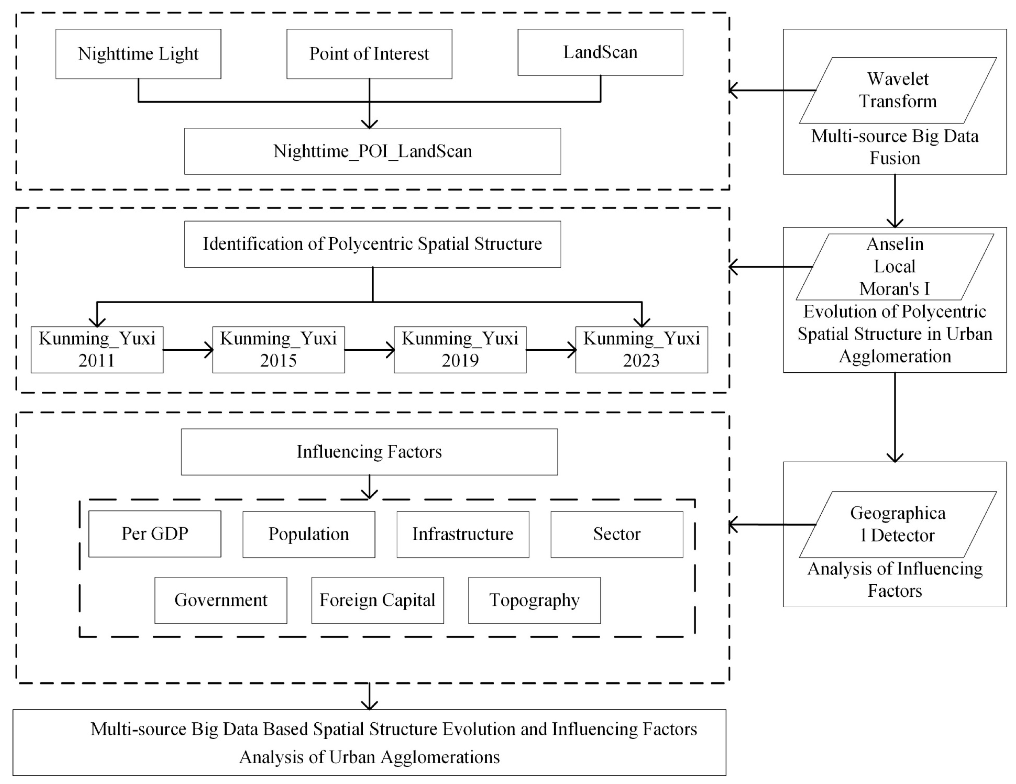
The technical process and study framework of this study are shown in Figure 5.

3. Results

3.1. Multisource Big Data Fusion

In the face of increasingly complex urban systems, individual data can no longer fully reflect the real spatial situation inside the city. Therefore, data fusion has been widely used in the scientific research of urban internal spaces [48,50,51]. Data fusion refers to combining and transforming information from single or multiple information sources obtained from different channels, times or spaces. The information obtained after data fusion not only greatly improves the timeliness and effectiveness of information extraction, but also provides more accurate and complete estimates and judgments than single information, thus reducing prediction errors and improving the reliability of data applications. NTL data, POI data and LandScan data have strong spatial correlations in urban areas. Specifically, the light value gradually decreases from the city center to the city edge, while the number of POIs and the population migration also decrease. Referring to the current fusion studies on NTL data and POI data, based on the spatial correlation of three kinds of data, this study attempted to fuse NTL, POI and LandScan data. After the fusion of NTL data, POI data and LandScan data, the result is shown in Figure 6.
Comparing the data before and after fusion, it can be observed that the NTL data, POI data and LandScan data are significantly spatially correlated after fusion. Furthermore, the noise is reduced after the data fusion and the description of the main urban agglomeration areas is more intuitive. Therefore, in the next step, this study will analyze the polycentric spatial structure evolution process of urban agglomerations based on the fused data.

3.2. The Evolution of the Polycentric Spatial Structure of Urban Agglomeration

In the development and expansion of urban agglomerations, the urban center undergoes the most significant spatial changes. In order to better analyze the spatial evolution of the Kunyu urban agglomeration, we focus on the changes in the urban center, including the number and size of urban centers. To better identify the urban centers of the Kunyu urban agglomeration in different periods, we define the urban center in detail in terms of spatial criteria. Drawing on existing studies, we propose four indicators to determine the range of the urban center and only areas that meet all four indicators based on clustering and outlier analysis can be confirmed as the urban center (Table 1) [51].
According to previous studies, it is generally believed that the center of a first-tier city in China is not less than 15 km. Therefore, this study selected 15 km as the minimum area value for identifying the center of the Kunyu urban agglomeration. The density standard deviation is used to remove some abnormally high values that have been identified as urban centers, such as airports and ports. The smaller the compactness index, the less compact the area shape, the more dispersed the urban area and vice versa for the compactness index of urban centers. Finally, this study also introduced the concept of the extension ratio to eliminate urban centers formed by narrow roads. In summary, the results obtained through clustering and outlier analysis represent potential urban centers. These potential city centers need to satisfy all four city center criteria we have proposed in order to be confirmed as the urban center of the Kunyu urban agglomeration.
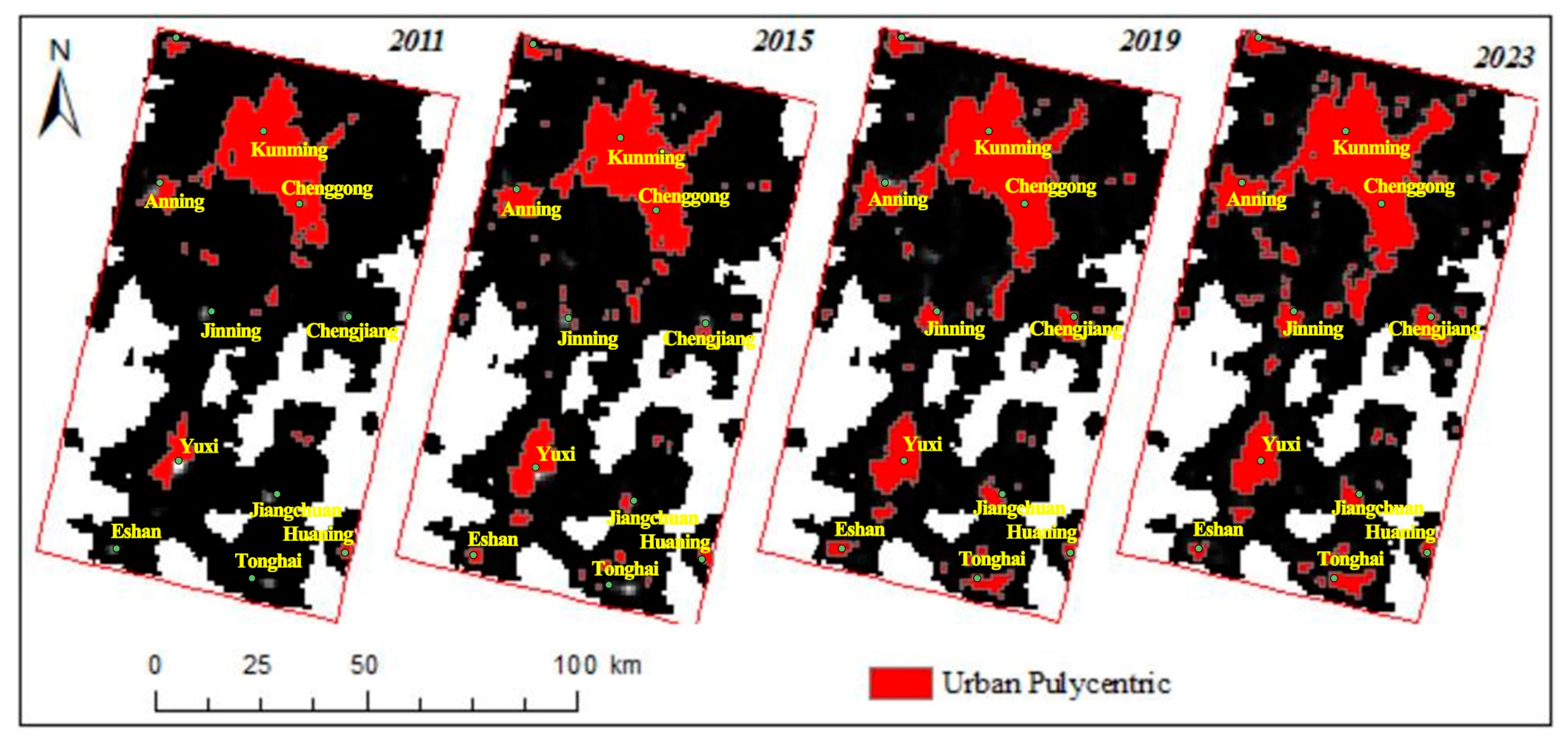
The centers of the Kunyu urban agglomeration identified from 2011 to 2023 are shown in Figure 7. The areas and proportions of the urban agglomeration centers identified from 2011 to 2023 were 747.12 square kilometers (8.52% of the total administrative area), 977.36 square kilometers (11.15% of the total administrative area), 1206.46 square kilometers (13.77% of the total administrative area) and 1234.92 square kilometers (16.25% of the total administrative area), respectively, indicating that the polycentric area of the Kunyu urban agglomeration is gradually increasing. From the perspective of urban spatial structure evolution theory, urban agglomeration development generally goes through the process of agglomeration, diffusion and reagglomeration [73]. That is, in the early stage of urban agglomeration development, the main center will gather a large population and economic development and then these factors will spread to the subcenters. Finally, they will be reagglomerated in the subcenters. As the cost of commuting and the population of the main center increase, the level of the subcenters in the urban agglomeration will also continue to increase, and when the center faces high congestion costs and low agglomeration economy, employment opportunities are likely to spread out, which will ultimately promote the polycentric development of the urban space. Correspondingly, in the early development of the Kunyu urban agglomeration, the economy and population were overly concentrated, so the polycenters were mainly concentrated in Kunming and Yuxi. With the continuous development of the urban agglomeration, the agglomeration cost of the central city also continues to increase and the phenomenon of central decentralization begins to appear in places like Jinning within the urban agglomeration. With the continuous increase in transport and regional connections, the urban centers of Jinning also began to emerge and the polycentric development within the urban agglomeration gradually eased the agglomeration pressure on the center of Kunming and Yuxi. Finally, the polycentric development within the urban agglomeration led to an obvious polycentric spatial structure.

3.3. Analysis of Factors Influencing Polycentric Spatial Structure

As one of the major urban agglomerations in China, the Kunyu urban agglomeration has developed rapidly in recent years. As shown in Figure 7, its spatial evolution is also obvious. In order to accurately evaluate the dominant factors of the polycentric spatial evolution of the Kunyu urban agglomeration in different periods, objective analysis was conducted using geographic detectors to analyze the potential influencing factors during different periods. Based on past urban development, there are many factors that influence urban spatial evolution, and the factors that influence the spatial evolution of different cities vary. Even for the same city, the factors that influence its spatial evolution at different times also differ. However, based on existing studies, there are several factors that are universally recognized by researchers, including the level of economic development, resident population size, industrial structure and transportation infrastructure conditions, as the development of all cities is inevitably influenced by these factors. In addition, we consider the actual development situation of the Kunyu urban agglomeration. Firstly, the Kunyu urban agglomeration is a national urban agglomeration established by the government, especially in recent years, as an important construction city node of the Belt and Road Initiative in China. The local government has provided a large amount of policy support, including both planning and economic development aspects. Secondly, the local government has been actively promoting the development of the Kunyu urban agglomeration at a high level, making it a very special urban agglomeration in China. Additionally, with the development of the Belt and Road Initiative, the Kunyu urban agglomeration, an important urban agglomeration node radiating in Southeast Asia, has a higher degree of openness compared to other urban agglomerations. Finally, the Kunyu urban agglomeration is located in the southwestern region of China with a higher altitude, making the topography play a certain restrictive role in the spatial evolution of the urban agglomeration. Therefore, considering all these factors, we selected indicators such as the level of economic development, resident population size, industrial structure, government intervention, transportation infrastructure, openness and topography as the main influencing factors for changes in the internal spatial structure of the Kunyu urban agglomeration. The specific explanations of the different factors are as follows:
Per GDP: The level of economic development can affect various microsocial and economic behaviors within the region and change their spatial distribution, thus further changing the spatial structure of the urban agglomeration. In the early stages of urban agglomeration development, the regions tend to be more centralized or single-centered, while in the later stages, they will move towards decentralization and polycentric development. The economic development of the urban agglomeration mainly comes from the nonagricultural economy, and this study measures the economic development level of the urban agglomeration by dividing the sum of the production value of the secondary and tertiary industries of the urban agglomeration by the total urban population to obtain the per capita GDP.
Population: The distribution of the permanent urban population within the urban agglomeration is used to examine the impact of the urban agglomeration scale agglomeration effect on its spatial structure. With the increase in the population, the urban area gradually tends to be dispersed due to the uneconomic agglomeration after the initial concentration development.
Infrastructure: The level of transportation facilities can affect the cost of transportation, thus affecting the agglomeration and diffusion of industrial and other economic activities. Due to the limitation of data availability of road traffic facilities between cities within the urban agglomerations, this paper adopts the road area per capita as the influencing variable of the level of traffic facilities on the spatial structure evolution of urban agglomerations, which is obtained by dividing the total road area of all cities in the urban agglomerations by the total population.
Sector: The agglomeration economy represented by manufacturing is generally considered to be able to promote population concentration. Sophisticated manufacturing industries with standardized production derive fewer agglomeration benefits from large cities but pay high land rents and wages, thus tend to spread toward lower-grade urban areas with lower costs. In this study, we use the ratio of secondary and tertiary industries to examine the influence of industrial structure on the evolution of the spatial structure of urban agglomerations.
Government: The government plays an important role in the regional development process, so if it has urban preferences in the policy-making process, it will influence the allocation of various economic factors among cities and thus the spatial structure of urban agglomerations. As a pilot area for urban-agglomeration-related planning in China, government intervention has shown significant effectiveness in the development of the Kunyu urban agglomeration. In this study, the share of fiscal expenditure of the higher level of government in the GDP of urban agglomerations is used.
Foreign capital: If foreign capital has a preference for the core cities of economically developed, it will promote the development of a single-center urban agglomeration. Located in the border area of Southeast Asia, foreign investment has to a certain extent affected the development of the urban agglomeration. This paper uses the proportion of actual foreign capital utilized to GDP in the year to examine the impact of the global economy on the spatial structure of urban agglomerations.
Topography: Different topographies can have an impact on the spread of a city, such as a slope and river system. Different topographical features can also affect land use prices and consequently influence the development of the city center. This study uses DEM to extract land slopes and river systems as variables for topographical influence.
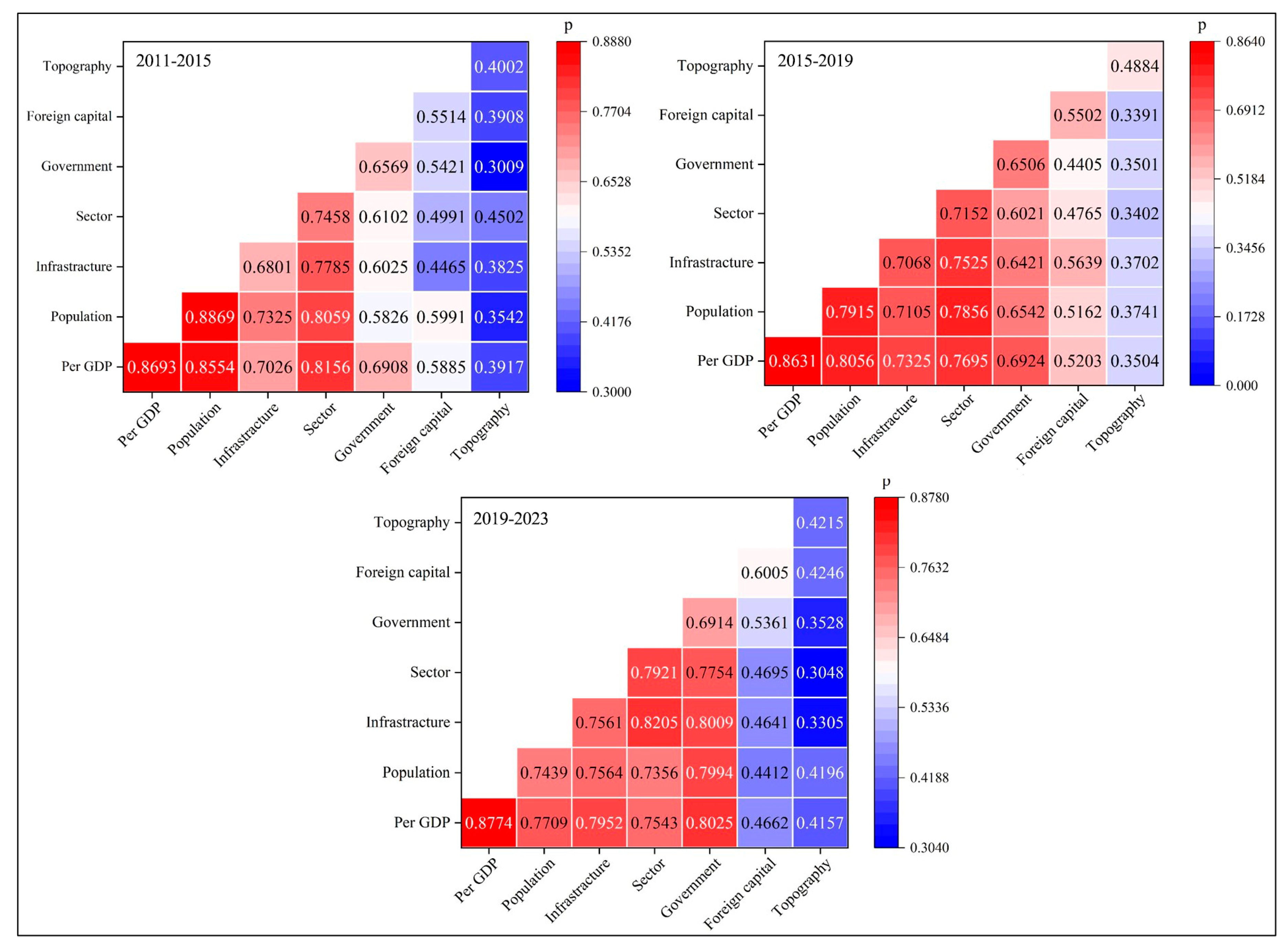
The evolution of the spatial structure in the Kunyu urban agglomeration is influenced by various factors, which are realized through geographical detectors. Firstly, different influencing factors are subjected to a Pearson correlation analysis. The results show that there is a positive correlation between the level of economic development, permanent population size, industrial structure, government intervention, transportation infrastructure, openness and topography, and all of them pass the significance test at a level of 0.01. Then, by using the differentiation and factor detection of geographical detectors, the explanatory power of each influencing factor for the spatial evolution of the urban agglomeration and their significance (p-values) are obtained. The results indicate that all the p-values are less than 0.100, which means that these influencing factors all have significant spatial differentiation and have a significant impact on the spatial evolution of the Kunyu urban agglomeration. The degree of explanation of different influencing factors for the spatial evolution of the Kunyu urban agglomeration in different periods is shown in Figure 8.
According to the results of the geographical detector, the roles of the influencing factors on the polycentric spatial structure of the city during different periods are different. Overall, the main factors driving the evolution of the polycentric spatial structure of the city in the Kunyu urban agglomeration are per GDP, population and government. Among these factors, the main driving forces from 2011 to 2014 were population, per GDP and sector. From 2014 to 2017, the main driving forces became per GDP, population and government. Conversely, from 2017 to 2023, the main driving forces became per GDP, government and infrastructure. Topography played a limited role in the evolution of the polycentric spatial structure of the Kunyu urban agglomeration.
Taking into account the actual development process of the Kunyu urban agglomeration, in the early stages, with a large influx of population, Kunming and Yuxi became the city centers, and after reaching a certain population capacity, they began to evacuate to surrounding areas, accompanied by significant changes in the industrial structure. With the development of the Kunyu urban agglomeration, relevant policies have been continuously introduced at the government level to guide its development. For example, the Yunnan Province’s 14th Five-Year Plan for National Economic and Social Development and the Vision for 2035, as well as the Kunming–Yuxi Twin City Planning, all explicitly propose promoting the coordinated and integrated development of the Kunyu urban agglomeration and creating a networked polycentric city at the regional level. The implementation of these policies has greatly promoted the evolution of the spatial structure of the Kunyu urban agglomeration. In addition, the Kunyu urban agglomeration is a strategic gateway for China to radiate into Southeast Asia, and the Belt and Road initiative also affects the development of the Kunyu urban agglomeration, gradually shifting towards regional coordinated development under government influence. Therefore, during this period, both economic development and the government played a significant role in promoting the polycentric spatial structure of the urban agglomeration. In summary, the process of evolution towards a polycentric spatial structure in the Kunyu urban agglomeration is the result of rapid economic development, led by the government and propelled by multiple factors. The Kunyu urban agglomeration has also shifted from the initial massive aggregation of economy and population to regional coordination under government guidance.

4. Discussion

The study of the traditional spatial structure of urban agglomerations mainly relies on statistical surveys and remote sensing data. However, statistical survey data have a slow update cycle and a short time series, while remote sensing data, such as NTL data, may be affected independently and therefore have errors when identifying the spatial structure of cities [54,55]. Therefore, there is currently a lack of simple and easily promotable methods for studying the spatial structure of urban agglomerations [74]. Based on the spatial characteristics of NTL data, POI data and LandScan data, this study fuses them into a new urban evaluation index and analyzes the evolution process of the polycentric spatial structure of the urban agglomeration. This study explores a simple and reliable system of multisource data fusion for identifying urban agglomeration, which can more comprehensively and objectively evaluate the spatial structure of the urban agglomeration and therefore more accurately reflect its development status. This allows us to obtain more accurate conclusions from the perspective of big data fusion compared to the existing studies on the spatial evolution of urban agglomerations [75,76].
Previous studies on the spatial structure of urban agglomerations tend to stay in a single time period due to data reasons [77]. However, in urban agglomerations, it is often more important to understand how the spatial structure has changed, including changes in city centers and the factors that drive these changes, which is crucial for the future development and planning of urban agglomerations [78,79,80]. Additionally, an urban agglomeration, as a complex system, may be driven by different factors and their changes in the process of development in different periods of time [81]. Many studies have analyzed the evolution process of urban agglomeration spatial structures and generally believe that China’s different urban agglomerations will undergo a spatial evolution process from a monocentric to polycentric evolution. Currently, most of China’s urban agglomerations are also in the stage of developing multiple centers [82], including the Kunyu urban agglomeration studied in this paper, which is consistent with other study results. In the development process of polycentric urban agglomerations, the factors that drive spatial changes may vary greatly due to differences in development backgrounds and opportunities between different urban agglomerations [83]. For example, the drivers of the spatial changes in the Yangtze River Delta urban agglomeration and the Pearl River Delta urban agglomeration are significantly different [84,85]. In the development of the Kunyu urban agglomeration, this study analyzed the driving factors that influenced the spatial evolution of the urban agglomeration in different periods, which is rarely seen in other studies, and the results are consistent with the actual development of the urban agglomeration, further demonstrating the value of this study.
Overall, the evolution and driving mechanisms of polycentric spatial structures in urban agglomerations are not a completely new issue and many studies have analyzed the spatial structure evolution process and driving mechanisms of different urban agglomerations in China [86,87,88]. Building upon previous studies, our study provides a detailed analysis of the spatial structure and driving factors of the Kunyu urban agglomeration. Additionally, our study fuses NTL data, POI data and LandScan data to create a new index for evaluating urban agglomeration spatial structures. Moreover, this study comprehensively analyzes the main influencing factors that drove the spatial evolution of the Kunyu urban agglomeration at different times, which has an important guiding role in the future spatial planning and coordinated high-quality development of the Kunyu urban agglomeration.
This study analyzes the evolution and the influencing factors at different periods of the polycentric spatial structure of the Kunyu urban agglomeration. However, there are still some limitations to our study. On the one hand, the POI data and LandScan data only estimate and simulate different attributes in a geographic space and there are still significant differences from the actual urban construction and population distribution. On the other hand, our analysis of driving mechanisms lacks important policy factors. Although the policy is difficult to quantify and analyze, it plays a critical role in guiding urban development in China, particularly urban master planning and urban coordination planning. The former determines the economic and social development goals of the city for a certain period in the future and determines the scale and direction of urban development. It coordinates the comprehensive layout and specific arrangement of urban space and various constructions. On the other hand, coordination planning and integration planning between different cities can break through the administrative barriers between cities, promote the flow of elements between cities and achieve regional integration. Therefore, the results of our study are more of an ideal state based on mathematical analysis. In future studies, we will attempt to expand the time scale and use longer time series to determine the factors that have influenced the polycentric spatial structure in the Kunyu urban agglomeration and provide a practical and feasible basis for the future development of the Kunyu urban agglomeration.

5. Conclusions

This study analyzes the evolution process and influencing factors of the polycentric spatial structure of the Kunyu urban agglomeration through the fusion of multisource big data. The identified results correspond highly to its actual development, which further highlights the importance of fusing different data for spatial evolution results. Moreover, this study also finds that the factors that dominate the evolution of the polycentric spatial structure of the Kunyu urban agglomerations in different periods vary, mainly showing that the influence of population on the spatial evolution of polycentricity is decreasing while the degree of influence of the government and foreign capital is increasing, and the aim of future development of the Kunyu is no longer to gather a large population but to start promoting synergistic development within the region under the guidance of the government.
The study of the spatial evolution patterns of the Kunyu urban agglomeration, which is a typical urban agglomeration in the central and western regions of China, is helpful for the development of urban agglomerations in the central and western regions of China. From the perspective of the spatial evolution of the Kunyu urban agglomeration, the dominant factors promoting the spatial evolution of the urban agglomeration have shifted from population and economic growth to government intervention. The Chinese government’s intervention policies focus more on regional coordinated development and internal integration within urban agglomerations. Therefore, for the future development of urban agglomerations in Western China, blindly pursuing population and economic growth is no longer suitable for the long-term development of urban agglomerations. Instead, more emphasis should be placed on government policy regulation from a macro perspective to promote regional coordination and integration of urban agglomerations into Central and Western China.
The structure and evolution of urban space is an important part of urban study and this study reflects on its important role in urban space structure and evolution through the integration of multiple data sources, which provides a reference for subsequent urban study. This study also draws the conclusion that the dominant factors are different in different periods based on the development of urban agglomerations, which provides an important reference for the development of urban agglomerations with high quality and refinement and also has some positive significance for the development and planning of other urban agglomerations of the same type.

Author Contributions

Conceptualization, J.Z. and X.Y.; methodology, J.Z. and X.Y.; software, X.Y.; validation, J.Z.; formal analysis, X.Y.; investigation, J.Z. and X.Y.; data curation, X.Y.; writing—original draft, J.Z. and X.Z.; writing—review and editing, R.Z.; X.Y. has contributed equally to this work and shares first authorship. All authors have read and agreed to the published version of the manuscript.

Funding

This research received no external funding.

Data Availability Statement

The data presented in this study are publicly available data sources stated in the citation. Please contact the corresponding author regarding data availability.

Conflicts of Interest

The authors declare no conflict of interest.

References

  1. Howard, E. Garden Cities of Tomorrow; Mit Press: Cambridge, MA, USA, 1965; Volume 23. [Google Scholar]
  2. Geddes, P. Cities in Evolution: An Introduction to the Town Planning Movement and to the Study of Civics; Williams: London, UK, 1915. [Google Scholar]
  3. Gottmann, J. Megalopolis or the Urbanization of the Northeastern Seaboard. Econ. Geogr. 1957, 33, 189. [Google Scholar] [CrossRef]
  4. Gottmann, J. Megalopolitan systems around the world. Ekistics 1976, 41, 109–113. [Google Scholar]
  5. Lang, R.; Knox, P.K. The New Metropolis: Rethinking Megalopolis. Reg. Stud. 2009, 43, 789–802. [Google Scholar] [CrossRef]
  6. Fang, C.; Song, J.; Zhang, Q. The formation, development and spatial heterogeneity patterns for the structures system of urban agglomerations in China. Acta Geogr. Sin. Chin. Ed. 2005, 60, 827. [Google Scholar]
  7. Liu, Y.; Zhang, X.; Pan, X.; Ma, X.; Tang, M. The spatial integration and coordinated industrial development of urban agglomerations in the Yangtze River Economic Belt, China. Cities 2020, 104, 102801. [Google Scholar] [CrossRef]
  8. Meng, Q.; Wang, C.; Wang, C. Examining the Evolution of China’s Urban Interlocking Networks Based on the Spatial Agglomeration of Producer Services. J. Urban Plan. Dev. 2022, 148, 04021063. [Google Scholar] [CrossRef]
  9. Liu, G.; Yao, X.; Luo, Z.; Kang, S.; Long, W.; Fan, Q.; Gao, P. Agglomeration centrality to examine spatial scaling law in cities. Comput. Environ. Urban Syst. 2019, 77, 101357. [Google Scholar] [CrossRef]
  10. Frings, H.; Kamb, R. The relative importance of portable and non-portable agglomeration effects for the urban wage premium. Reg. Sci. Urban Econ. 2022, 95, 103786. [Google Scholar] [CrossRef]
  11. Ma, D.; Zhu, Q. Innovation in emerging economies: Research on the digital economy driving high-quality green development. J. Bus. Res. 2022, 145, 801–813. [Google Scholar] [CrossRef]
  12. Chen, Y.; Zhu, M.; Lu, J.; Zhou, Q.; Ma, W. Evaluation of ecological city and analysis of obstacle factors under the background of high-quality development: Taking cities in the Yellow River Basin as examples. Ecol. Indic. 2020, 118, 106771. [Google Scholar] [CrossRef]
  13. Odell, H.; Navarro-López, E.M.; Pinto, N.; Deas, I. Detecting shifts in metropolitan structure: A spatial network per-spective. Environ. Plan. B Urban Anal. City Sci. 2022, 49, 1912–1928. [Google Scholar] [CrossRef]
  14. Hillier, B.; Hanson, J. The Social Logic of Space; Cambridge University Press: Cambridge, UK, 1989. [Google Scholar]
  15. Zhong, C.; Schläpfer, M.; Arisona, S.M.; Batty, M.; Ratti, C.; Schmitt, G. Revealing centrality in the spatial structure of cities from human activity patterns. Urban Stud. 2017, 54, 437–455. [Google Scholar] [CrossRef] [Green Version]
  16. Shen, Y.; Karimi, K. Urban evolution as a spatio-functional interaction process: The case of central Shanghai. J. Urban Des. 2018, 23, 42–70. [Google Scholar] [CrossRef]
  17. Liu, X.; Huang, J.; Lai, J.; Zhang, J.; Senousi, A.M.; Zhao, P. Analysis of urban agglomeration structure through spatial network and mobile phone data. Trans. GIS 2021, 25, 1949–1969. [Google Scholar] [CrossRef]
  18. Hillier, B.; Penn, A.; Hanson, J.; Grajewski, T.; Xu, J. Natural movement: Or configuration and attraction in urban pedestrian movement. Environ. Plan. B Plan. Des. 1993, 20, 29–66. [Google Scholar] [CrossRef] [Green Version]
  19. Penn, A.; Hillier, B.; Banister, D.; Xu, J. Configurational modelling of urban movement networks. Environ. Plan. B Plan. Des. 1998, 25, 59–84. [Google Scholar] [CrossRef] [Green Version]
  20. Hillier, B. Space is the Machine: A Configurational Theory of Architecture; Cambridge University Press: Cambridge, UK, 1996. [Google Scholar]
  21. Salvati, L. Towards a Polycentric Region? The Socio-economic Trajectory of R ome, an ‘Eternally Mediterranean’ City. Tijdschr. Voor Econ. En Soc. Geogr. 2014, 105, 268–284. [Google Scholar] [CrossRef]
  22. Ma, H.; Xu, X. Knowledge Polycentricity of China’s Urban Agglomerations. J. Urban Plan. Dev. 2022, 148, 04022014. [Google Scholar] [CrossRef]
  23. Sweeney, S.; Steigerwald, D.G.; Davenport, F.; Eakin, H. Mexican maize production: Evolving organizational and spatial structures since 1980. Appl. Geogr. 2013, 39, 78–92. [Google Scholar] [CrossRef]
  24. Li, Y.; Liu, X. How did urban polycentricity and dispersion affect economic productivity? A case study of 306 Chinese cities. Landsc. Urban Plan. 2018, 173, 51–59. [Google Scholar] [CrossRef]
  25. Liu, X.; Wang, M. How polycentric is urban China and why? A case study of 318 cities. Landsc. Urban Plan. 2016, 151, 10–20. [Google Scholar] [CrossRef]
  26. Harrison, J.; Hoyler, M.; Derudder, B.; Liu, X.; Meijers, E. Governing polycentric urban regions. Territ. Politi. Gov. 2022, 11, 213–221. [Google Scholar] [CrossRef]
  27. Li, Y.; Derudder, B. Dynamics in the polycentric development of Chinese cities, 2001–2016. Urban Geogr. 2022, 43, 272–292. [Google Scholar] [CrossRef]
  28. Derudder, B.; Meijers, E.; Harrison, J.; Hoyler, M.; Liu, X. Polycentric urban regions: Conceptualization, identification and implications. Reg. Stud. 2022, 56, 1–6. [Google Scholar] [CrossRef]
  29. Hajrasouliha, A.H.; Hamidi, S. The typology of the American metropolis: Monocentricity, polycentricity, or gener-alized dispersion? Urban Geogr. 2017, 38, 420–444. [Google Scholar] [CrossRef]
  30. McMillen, D.P.; Smith, S.C. The number of subcenters in large urban areas. J. Urban Econ. 2003, 53, 321–338. [Google Scholar] [CrossRef]
  31. Önder, D.E.; Gigi, Y. Reading Urban Spaces by the Space Syntax Method. In The New Realm of Architectural Design; Thames Hudson Ltd.: London, UK, 2009; p. 827. [Google Scholar]
  32. Mohamed, A.A.; Ubarevičienė, R.; van Ham, M. Morphological evaluation and regeneration of informal settlements: An experience-based urban design approach. Cities 2022, 128, 103798. [Google Scholar] [CrossRef]
  33. Özcan, K.; Eren, F. A Study on the Future of Urban Models in the Third Millennium: A Sustainable Urban Model for Kırıkkale, Turkey. The Sustainable City IV: Urban Regeneration and Sustainability; WIT Press: Billerica, MA, USA, 2006; Volume 93. [Google Scholar] [CrossRef] [Green Version]
  34. Wang, T.; Yue, W.; Ye, X.; Liu, Y.; Lu, D. Re-evaluating polycentric urban structure: A functional linkage perspective. Cities 2020, 101, 102672. [Google Scholar] [CrossRef]
  35. Heikkila, E.J.; Xu, Y. Polycentric Urbanization and Sustainable Development in China. Glob. Policy 2022, 13, 69–78. [Google Scholar] [CrossRef]
  36. Buckwalter, D.W. Changing employment subcenters and opportunity in the Pittsburgh metropolitan area. J. Urban Aff. 2021, 1–18. [Google Scholar] [CrossRef]
  37. Yu, L.; Zheng, W.; Yu, T.; Wu, Y. How to identify urban centers/subcenters in metropolises? An analytical review. Habitat. Int. 2021, 115, 102397. [Google Scholar] [CrossRef]
  38. Sun, B.; Yin, C. Relationship between multi-scale urban built environments and body mass index: A study of China. Appl. Geogr. 2018, 94, 230–240. [Google Scholar] [CrossRef]
  39. Lv, Y.; Zhou, L.; Yao, G.; Zheng, X. Detecting the true urban polycentric pattern of Chinese cities in morphological dimensions: A multiscale analysis based on geospatial big data. Cities 2021, 116, 103298. [Google Scholar] [CrossRef]
  40. Vaidyanathan, V.; King, R.A.; de Jong, M. Understanding urban transportation in India as polycentric system. Policy Soc. 2013, 32, 175–185. [Google Scholar] [CrossRef] [Green Version]
  41. Wang, Y.; Niu, Y.; Li, M.; Yu, Q.; Chen, W. Spatial structure and carbon emission of urban agglomerations: Spatio-temporal characteristics and driving forces. Sustain. Cities Soc. 2022, 78, 103600. [Google Scholar] [CrossRef]
  42. Yang, Z.; Chen, Y.; Guo, G.; Zheng, Z.; Wu, Z. Using nighttime light data to identify the structure of polycentric cities and evaluate urban centers. Sci. Total Environ. 2021, 780, 146586. [Google Scholar] [CrossRef]
  43. Lorens, P.; Golędzinowska, A. Developing Polycentricity to Shape Resilient Metropolitan Structures: The Case of the Gdansk–Gdynia–Sopot Metropolitan Area. Urban Plan. 2022, 7, 159–171. [Google Scholar] [CrossRef]
  44. Shi, K.; Yu, B.; Hu, Y.; Huang, C.; Chen, Y.; Huang, Y.; Chen, Z.; Wu, J. Modeling and mapping total freight traffic in China using NPP-VIIRS nighttime light composite data. GIScience Remote Sens. 2015, 52, 274–289. [Google Scholar] [CrossRef]
  45. Shi, K.; Wu, Y.; Liu, S.; Chen, Z.; Huang, C.; Cui, Y. Mapping and evaluating global urban entities (2000–2020): A novel perspective to delineate urban entities based on consistent nighttime light data. GIScience Remote Sens. 2023, 60, 2161199. [Google Scholar] [CrossRef]
  46. Niedomysl, T.; Hall, O.; Bustos, M.F.A.; Ernstson, U. Using Satellite Data on Nighttime Lights Intensity to Estimate Contemporary Human Migration Distances. Ann. Assoc. Am. Geogr. 2017, 107, 591–605. [Google Scholar] [CrossRef]
  47. Bakillah, M.; Liang, S.; Mobasheri, A.; Jokar Arsanjani, J.; Zipf, A. Fine-resolution population mapping using Open-StreetMap points-of-interest. Int. J. Geogr. Inf. Sci. 2014, 28, 1940–1963. [Google Scholar] [CrossRef]
  48. He, X.; Zhou, C.; Zhang, J.; Yuan, X. Using Wavelet Transforms to Fuse Nighttime Light Data and POI Big Data to Extract Urban Built-Up Areas. Remote Sens. 2020, 12, 3887. [Google Scholar] [CrossRef]
  49. He, X.; Cao, Y.; Zhou, C. Evaluation of Polycentric Spatial Structure in the Urban Agglomeration of the Pearl River Delta (PRD) Based on Multi-Source Big Data Fusion. Remote Sens. 2021, 13, 3639. [Google Scholar] [CrossRef]
  50. He, X.; Zhang, R.; Yuan, X.; Cao, Y.; Zhou, C. The role of planning policy in the evolution of the spatial structure of the Guangzhou metropolitan area in China. Cities 2023, 137, 104284. [Google Scholar] [CrossRef]
  51. Zhou, Y.; He, X.; Zhu, Y. Identification and Evaluation of the Polycentric Urban Structure: An Empirical Analysis Based on Multi-Source Big Data Fusion. Remote Sens. 2022, 14, 2705. [Google Scholar] [CrossRef]
  52. Lyu, Y.; Jiang, F. Spatial and temporal distribution of population in urban agglomerations changes in China. Sci. Rep. 2022, 12, 8315. [Google Scholar] [CrossRef]
  53. Mubareka, S.; Ehrlich, D.; Bonn, F.; Kayitakire, F. Settlement location and population density estimation in rugged terrain using information derived from Landsat ETM and SRTM data. Int. J. Remote Sens. 2008, 29, 2339–2357. [Google Scholar] [CrossRef]
  54. Nguyen, L.H.; Nghiem, S.V.; Henebry, G.M. Expansion of major urban areas in the US Great Plains from 2000 to 2009 using satellite scatterometer data. Remote Sens. Environ. 2018, 204, 524–533. [Google Scholar] [CrossRef]
  55. Wu, Y.; Shi, K.; Cui, Y.; Liu, S.; Liu, L. Differentiated effects of morphological and functional polycentric urban spatial structure on carbon emissions in China: An empirical analysis from remotely sensed nighttime light approach. Int. J. Digit. Earth 2023, 16, 532–551. [Google Scholar] [CrossRef]
  56. Hennig, B.D. The growth and decline of urban agglomerations in Germany. Environ. Plan. A Econ. Space 2019, 51, 1209–1212. [Google Scholar] [CrossRef] [Green Version]
  57. He, X.; Zhu, Y.; Chang, P.; Zhou, C. Using Tencent User Location Data to Modify Night-Time Light Data for Delineating Urban Agglomeration Boundaries. Front. Environ. Sci. 2022, 10, 860365. [Google Scholar] [CrossRef]
  58. Wang, C.; Yin, L. Defining Urban Big Data in Urban Planning: Literature Review. J. Urban Plan. Dev. 2023, 149, 04022044. [Google Scholar] [CrossRef]
  59. Priyashani, N.; Kankanamge, N.; Yigitcanlar, T. Multisource Open Geospatial Big Data Fusion: Application of the Method to Demarcate Urban Agglomeration Footprints. Land 2023, 12, 407. [Google Scholar] [CrossRef]
  60. Zheng, S.; Du, R. How does urban agglomeration integration promote entrepreneurship in China? Evidence from regional human capital spillovers and market integration. Cities 2020, 97, 102529. [Google Scholar] [CrossRef]
  61. Kurniati, A.C.; Nitivattananon, V. Factors influencing urban heat island in Surabaya, Indonesia. Sustain. Cities Soc. 2016, 27, 99–105. [Google Scholar] [CrossRef]
  62. Zhuang, Z.; Fu, S.; Lan, S.; Yu, H.; Yang, C.; Huang, G.Q. Research on economic benefits of multi-city logistics de-velopment based on data-driven analysis. Adv. Eng. Inform. 2021, 49, 101322. [Google Scholar] [CrossRef]
  63. Yu, Z.; Xiao, Z.; Liu, X. Characterizing the spatial-functional network of regional industrial agglomerations: A da-ta-driven case study in China’s greater bay area. Appl. Geogr. 2023, 152, 102901. [Google Scholar] [CrossRef]
  64. Li, L.; Ma, S.; Zheng, Y.; Xiao, X. Integrated regional development: Comparison of urban agglomeration policies in China. Land Use Policy 2022, 114, 105939. [Google Scholar] [CrossRef]
  65. Sun, D.; Li, S.; Zheng, W.; Croitoru, A.; Stefanidis, A.; Goldberg, M. Mapping floods due to Hurricane Sandy using NPP VIIRS and ATMS data and geotagged Flickr imagery. Int. J. Digit. Earth 2016, 9, 427–441. [Google Scholar] [CrossRef]
  66. Song, Y.; Long, Y.; Wu, P.; Wang, X. Are all cities with similar urban form or not? Redefining cities with ubiquitous points of interest and evaluating them with indicators at city and block levels in China. Int. J. Geogr. Inf. Sci. 2018, 32, 2447–2476. [Google Scholar] [CrossRef]
  67. Guo, H.; Liu, H.; Wang, S.; Zhang, Y. An Automatic Urban Function District Division Method Based on Big Data Analysis of POI. J. Inf. Process. Syst. 2021, 17, 645–657. [Google Scholar]
  68. Hanberry, B.B. Imposing consistent global definitions of urban populations with gridded population density models: Irreconcilable differences at the national scale. Landsc. Urban Plan. 2022, 226, 104493. [Google Scholar] [CrossRef]
  69. Raju, K.N.P.; Kumar, S.; Mohan, K.; Pandey, M.K. Urban cadastral mapping using very high resolution remote sensing data. J. Indian Soc. Remote Sens. 2008, 36, 283–288. [Google Scholar] [CrossRef]
  70. Lou, G.; Chen, Q.; He, K.; Zhou, Y.; Shi, Z. Using Nighttime Light Data and POI Big Data to Detect the Urban Centers of Hangzhou. Remote Sens. 2019, 11, 1821. [Google Scholar] [CrossRef] [Green Version]
  71. Peng, W.; Fan, Z.; Duan, J.; Gao, W.; Wang, R.; Liu, N.; Li, Y.; Hua, S. Assessment of interactions between influencing factors on city shrinkage based on geographical detector: A case study in Kitakyushu, Japan. Cities 2022, 131, 103958. [Google Scholar] [CrossRef]
  72. Xie, Z.; Yuan, M.; Zhang, F.; Chen, M.; Shan, J.; Sun, L.; Liu, X. Using Remote Sensing Data and Graph Theory to Identify Polycentric Urban Structure. IEEE Geosci. Remote Sens. Lett. 2023, 20, 3235943. [Google Scholar] [CrossRef]
  73. van den Berg, L.; Drewett, R.; Klaassen, L.H.; Rossi, A.; Vijverberg, C.H.T. Urban Europe: A Study of Growth and Decline; Pergamon Press: Oxford, UK, 1982. [Google Scholar]
  74. Ma, M.; Lang, Q.; Yang, H.; Shi, K.; Ge, W. Identification of Polycentric Cities in China Based on NPP-VIIRS Nighttime Light Data. Remote Sens. 2020, 12, 3248. [Google Scholar] [CrossRef]
  75. Zheng, W.; Kuang, A.; Liu, Z.; Wang, X. Analysing the spatial structure of urban growth across the Yangtze River Middle reaches urban agglomeration in China using NPP-VIIRS night-time lights data. Geojournal 2021, 87, 2753–2770. [Google Scholar] [CrossRef]
  76. Wang, C.; Yu, B.; Chen, Z.; Liu, Y.; Song, W.; Li, X.; Wu, J. Evolution of urban spatial clusters in China: A graph-based method using nighttime light data. Ann. Am. Assoc. Geogr. 2022, 112, 56–77. [Google Scholar] [CrossRef]
  77. Zhang, P.; Kohli, D.; Sun, Q.; Zhang, Y.; Liu, S.; Sun, D. Remote sensing modeling of urban density dynamics across 36 major cities in China: Fresh insights from hierarchical urbanized space. Landsc. Urban Plan. 2020, 203, 103896. [Google Scholar] [CrossRef]
  78. Liu, K.; Zhao, P.; Wan, D.; Hai, X.; He, Z.; Liu, Q.; Qu, Y.; Zhang, X.; Li, K.; Yu, L. Using mobile phone big data to discover the spatial patterns of rural migrant workers’ return to work in China’s three urban agglomerations in the post-COVID-19 era. Environ. Plan. B Urban Anal. City Sci. 2022, 50, 878–894. [Google Scholar] [CrossRef]
  79. Hahs, A.K.; McDonnell, M.J. Selecting independent measures to quantify Melbourne’s urban–rural gradient. Landsc. Urban Plan. 2006, 78, 435–448. [Google Scholar] [CrossRef]
  80. Peck, F.; Cabras, I. Impacts of Agglomeration on Call Centre Operations: Evidence from North West England. Reg. Stud. 2009, 43, 923–934. [Google Scholar] [CrossRef] [Green Version]
  81. Yang, T.; Pan, H.; Hewings, G.; Jin, Y. Understanding urban sub-centers with heterogeneity in agglomeration economies—Where do emerging commercial establishments locate? Cities 2019, 86, 25–36. [Google Scholar] [CrossRef]
  82. Wang, H.; Zhang, B.; Liu, Y.; Liu, Y.; Xu, S.; Zhao, Y.; Chen, Y.; Hong, S. Urban expansion patterns and their driving forces based on the center of gravity-GTWR model: A case study of the Beijing-Tianjin-Hebei urban agglomeration. J. Geogr. Sci. 2020, 30, 297–318. [Google Scholar] [CrossRef]
  83. Li, W.; Sun, B.; Zhang, T. Spatial structure and labour productivity: Evidence from prefectures in China. Urban Stud. 2019, 56, 1516–1532. [Google Scholar] [CrossRef]
  84. Andres, L.; Bryson, J.R.; Graves, W.; Warf, B. Urban value chains and re-framing agglomeration-centric conceptions of urban theory. Urban Geogr. 2022, 1–22. [Google Scholar] [CrossRef]
  85. Yu, X.; Wu, Z.; Zheng, H.; Li, M.; Tan, T. How urban agglomeration improve the emission efficiency? A spatial econometric analysis of the Yangtze River Delta urban agglomeration in China. J. Environ. Manag. 2020, 260, 110061. [Google Scholar] [CrossRef]
  86. Zhang, Z.; Wang, B.; Buyantuev, A.; He, X.; Gao, W.; Wang, Y.; Dawazhaxi; Yang, Z. Urban agglomeration of Kunming and Yuxi cities in Yunnan, China: The relative importance of government policy drivers and environmental constraints. Landsc. Ecol. 2019, 34, 663–679. [Google Scholar] [CrossRef]
  87. Anees, M.M.; Mann, D.; Sharma, M.; Banzhaf, E.; Joshi, P.K. Assessment of urban dynamics to understand spatio-temporal differentiation at various scales using remote sensing and geospatial tools. Remote Sens. 2020, 12, 1306. [Google Scholar] [CrossRef] [Green Version]
  88. Huang, J.; Sun, Z.; Du, M. Differences and Drivers of Urban Resilience in Eight Major Urban Agglomerations: Evidence from China. Land 2022, 11, 1470. [Google Scholar] [CrossRef]
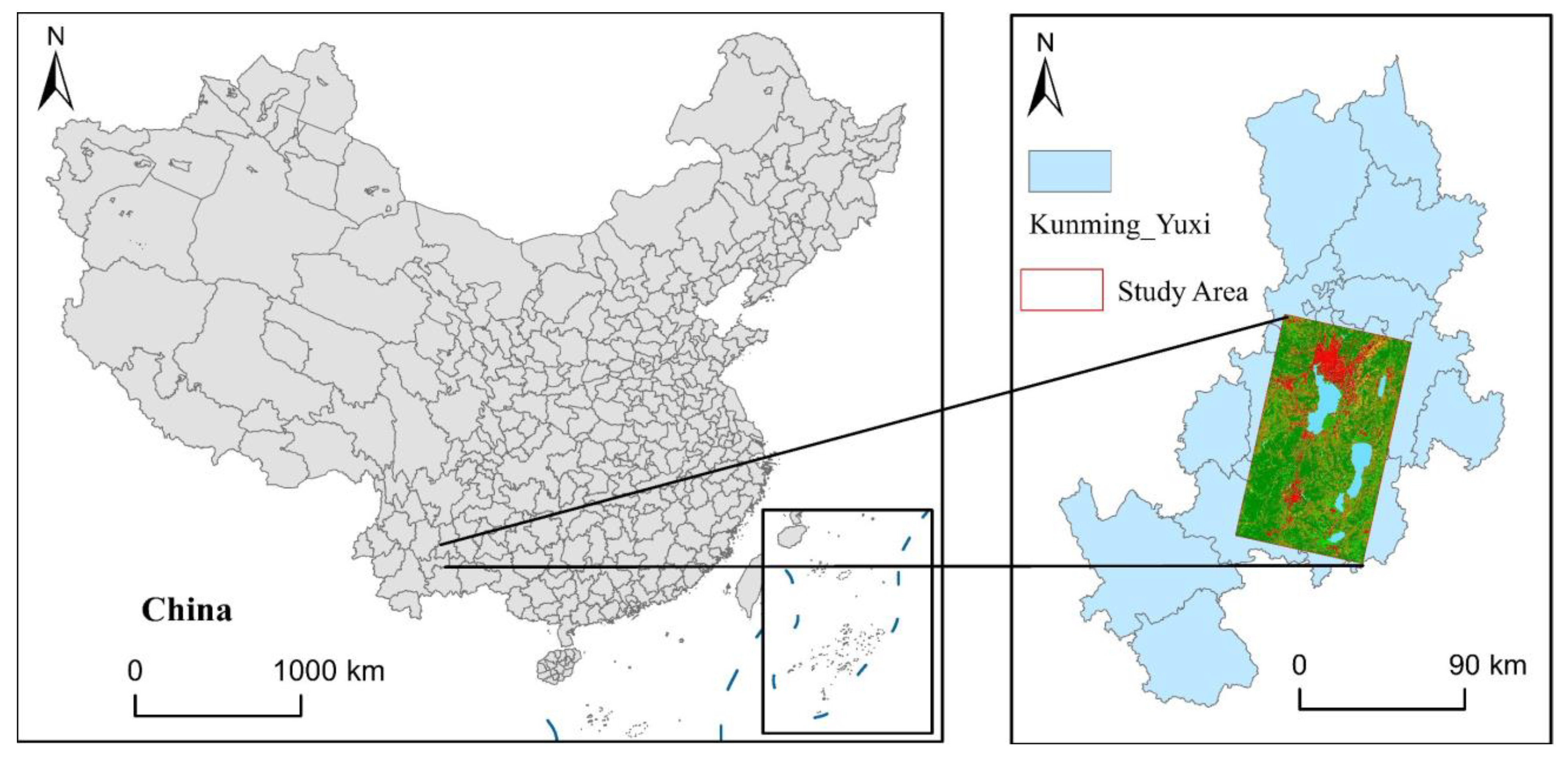
Figure 1. Study area.
Land 12 01340 g001
Figure 2. NTL data from 2011 to 2023.
Land 12 01340 g002
Figure 3. POI data from 2011 to 2023.
Land 12 01340 g003
Figure 4. LandScan data from 2011 to 2023.
Land 12 01340 g004
Figure 5. Study framework.
Land 12 01340 g005
Figure 6. Data fusion result.
Land 12 01340 g006
Figure 7. Polycentric spatial structure evolution of Kunyu urban agglomeration.
Land 12 01340 g007
Figure 8. Geographical detector results of different periods.
Land 12 01340 g008
Table 1. Criteria for judging urban centers in urban agglomerations.
CriteriaFormulaUrban CenterNonurban CenterDefinition
Area S = N × C S 15   km 2 < 15   km 2 N is the number of pixels, CS is the size of the pixel.
Standard Deviation S T D = 1 N i = 1 N   ( x i x ¯ ) 2 >0≈0 x i is the value of the i t h   p i x e l , x ¯ is the average value of the pixels.
Compactness Index C I = 4 π S / P 2 Approaching 1Approaching 0 P is the perimeter of the urban center.
Extension Ratio E L G = L E N / W I D <3 3 L E N   a n d   W I D are, respectively, the length and width of the minimum bounding rectangle of the urban center.
Disclaimer/Publisher’s Note: The statements, opinions and data contained in all publications are solely those of the individual author(s) and contributor(s) and not of MDPI and/or the editor(s). MDPI and/or the editor(s) disclaim responsibility for any injury to people or property resulting from any ideas, methods, instructions or products referred to in the content.