Abstract
Digital cadastral maps with accompanying land-related attributes have become a fundamental dataset for many application fields, e.g., spatial planning and development, protecting state lands, securing of land tenure, facilitating land reforms, agriculture, forestry, land management, taxation, etc. In order to fulfil its main objectives, cadastral data needs to be available and accessible, which is, among the others, emphasized also within the United Nations Framework for Effective Land Administration (FELA). This is not only important on the national level but also beyond, including at the European level where use cases and consequently demand for pan-European data sets have evolved in recent years. In order to satisfy these needs, several initiatives regarding cadastral and other geospatial data have been launched in the last 20 years. It started with the Permanent Committee on Cadastre in the European Union, the European Land Information Service, INSPIRE, UN-GGIM Europe and recent European policies on open data and high-value datasets. Our main question is, did those initiatives result in the possibility of building a cadastral map of Europe or not? Is it possible to create a cadastral map of Europe on the desktop or an open online GIS application? Within the paper, we take the opportunity to reflect on the development and implementation of European spatial data infrastructure (INSPIRE) with the main focus on the availability and accessibility of cadastral data. We also take into consideration other European initiatives related to cadastral data. The overall findings show that there is still work to be carried out. Technological developments and recent policy initiatives will certainly be drivers for future improvement.
1. Introduction
Land is an essential natural resource, both for the survival and prosperity of humanity and for the maintenance of all terrestrial ecosystems [1]. However, land is also a scarce resource that needs to be carefully and efficiently managed through the Land Administration Systems (LAS). A contemporary Land Administration System, with the functionalities of determining, recording and disseminating information about land rights, land value and use of land and its associated resources [2], provides a country with the infrastructure to implement land-related policies and land management strategies [3]. The LAS processes include the determination of land-related rights, restrictions and responsibilities (RRR), and other land attributes, surveying and describing these, their detailed documentation, and the provision of relevant information, as defined also by the ISO standard on Land Administration Domain Model [4]. LAS should ideally guarantee ownership and secure land tenure, support the land and property tax system, constitute security for credit systems, develop and monitor land markets, protect state lands, reduce land disputes, facilitate land reform, support urban planning and infrastructure development, and support land management following the Sustainable Development Goals [5].
Countries have developed different solutions when transferring traditional “paper-based” land administration systems to digital systems in the last decades—dependent also on the historical particularities of land registration systems. Despite the differences in land administration systems, the challenges the countries are meeting with are similar. This is also the reason why there has been an international consensus on the standardisation of the land administration domain model [6]. The ISO standard was published in 2012. However, the standard has not brought a universal solution, as it is more a conceptual scheme that can be adjusted to the needs of the particular land administration system. This is also the reason that many researchers have dealt with the challenges of introducing or upgrading LADM in the country-specific LAS [7,8,9]. Lately, particular attention has been given to the revision of LADM [10], cadastral processes and data dissemination processes, also in relation to LADM [11], and land administration system upgrades challenges [12].
It has to be emphasised that in many jurisdictions, the key LAS component remained the land cadastre—with georeferenced cadastral maps and land-related attributes organised within Land Information Systems (LIS) that became an integral part of National Geospatial Data Infrastructure (NDSI), as also suggested by FIG guidelines “Cadastre 2014” [13,14]. Land cadastre plays an important role in granting access to land information and maintaining land data in accordance with various transactions that occur on land. LASs with land cadastre evolve in response to changes in people-to-land relationships primarily driven by the development of land markets. However, countries are also beginning to make increasing demands on their administrative infrastructure, aiming to improve land management. While land markets remain the major driver, other pressures are now beginning to be absorbed by land administration institutions through the prism of sustainable development [3,15].
By definition [16], a land cadastre is normally a parcel-based, up-to-date land information system containing a record of interests in land, e.g., RRRs. It usually includes a geometric description of land parcels, e.g., maps showing the size and location of land parcels, linked to other records describing the nature of the land and the land-related interests [17]. The cadastral map is generally the most accurate map of an area. With the development of geographic/geospatial information systems (GIS), digital land maps, i.e., cadastral maps, have become a key component of any contemporary LAS. Therefore, cadastral maps play an important role in granting access to land information and maintaining cadastral data in accordance with transactions that occur on land. This is one of the reasons why land cadastre with cadastral maps has been recognised as an important part of geospatial information infrastructure within a country and beyond [18]. Namely, integrated geospatial information with land data are an essential base for an effective and efficient land information system to support the administration of land policy frameworks, customary rights, security of tenure, property rights, sustainable development and overall social, environmental and economic well-being [19].
1.1. Why Do We Need a Cadastral Map of Europe?
Cadastral systems are complex and typically have significant differences in legislation, regulation and survey practices between jurisdictions. However, the objectives of a cadastral system tend to be essentially the same [20]. An important and significant milestone for land administration globally arrived when the United Nations Committee of Experts on Global Geospatial Information Management (UN-GGIM) welcomed and adopted the Framework for Effective Land Administration (FELA) in 2020 [21] since the security of land tenure is a prerequisite for tackling most of the sustainable development challenges. The uptake of the FELA by the various UN Member States, also EU countries, is currently happening, and this is an ideal moment to contribute to and advocate for the contemporary LAS [22].
In order to serve its purpose and assure transparency in LAS, cadastral data, including cadastral maps, should be open and publicly available to all. At the European level, one of the first initiatives in this direction came with the establishment of the Permanent Committee on Cadastre in the European Union (PCC) in 2002 [23]. Another initiative came in 2006 when the European Land Information Service (EULIS) [24] was officially launched with the aim of providing access to land and property information across Europe to meet the needs of professional users: lenders, conveyancers and other professional groups.
In 2007, with the adoption of the INSPIRE Directive [25], cadastral data officially became one of the basic reference spatial data sets in the European Spatial Data Infrastructure (ESDI). INSPIRE scope applies to spatial data held by, or on behalf of, public administration in the performance of public tasks. In total, 34 data themes that fall under INSPIRE, including cadastral parcels, should be available and accessible through the INSPIRE infrastructure. According to the INSPIRE roadmap, the infrastructure should be already fully operational. Since INSPIRE is based on national SDIs operated by EU MS and EFTA countries, ultimately, it should enable the creation of different pan-European datasets. Thus, it would also mean the creation of a cadastral map of Europe. Some questions arise here: Is it really possible? Is the cadastral data available and accessible? Is the data open and free? Are there any other obstacles, e.g., technology, interoperability, semantics, etc.? Is it possible for a user to create a cadastral map of Europe on the desktop or an online GIS application and combine cadastral data from different sources in an interoperable way?
Many ideas and movements have gone recently towards this goal, and there are many possible users, but where are we now?
There is a clear, strong demand for the creation of pan-European data sets including the European cadastral map. The main user here is the European Commission (EC) itself, especially DG JUST, DG AGRI and DG ESTAT regarding the cadastral data. Until a few years ago, the requirements of the EC and EU Agencies for geospatial information were limited in terms of scope and scale. In most cases, they were met by the products delivered by EuroGeographics [26]. However, in recent years, use cases and, consequently, demand have evolved. This requires integrating and processing different types of geospatial data with a wider scope, higher spatial quality, and better resolution. The number of spatial analyses has increased and is now common practice in many services of the Commission. Spatial analyses support policy making in domains such as environment, statistics, agriculture, transport and energy, or other Community data programmes such as Copernicus. In addition, the adoption of the UN 2030 Agenda for Sustainable Development [5] and of the related indicator framework for monitoring the Sustainable Development Goals (SDGs) also resulted in greater demand for various types of data, including geospatial data.
In this paper, we are investigating the current status of the availability and accessibility of cadastral data in Europe, primarily through the INSPIRE infrastructure but also in relation to other initiatives with the main aim answering the above-posted questions. By availability, we aim for the existence of metadata describing spatial data, while by accessibility, we aim for the existence of related services for spatial data viewing and downloading. Since the deadline for the INSPIRE implementation has already passed in 2021, it is the right moment to investigate how much European infrastructure fulfilled the goal and whether it is possible to build a cadastral map of Europe.
In addition to the INSPIRE, the European Commission adopted the Implementing Regulation on a list of High-Value Datasets in December 2022 [27]. This regulation supplements the Open Data Directive [28] and contains a list of high-value data sets that public authorities will have to make available for re-use free of charge. One of them is cadastral parcels as defined under the INSPIRE Directive. It is also worth noting that UN-GGIM: Europe undertakes similar work by defining core spatial datasets to support UN Sustainable Development Goals (SDGs). Again, cadastral parcels are recognised as one of the core datasets.
This paper is organised as follows. Section 2 provides an overview of the legal and organisational context of the INSPIRE Directive with a primary focus on cadastral data in Europe. This section also includes the most substantial part of the work, which is the analysis of the availability and accessibility of cadastral data in Europe through the INSPIRE Geoportal. Other initiatives related to cadastral data on a European scale are presented in Section 3, where we also take into account recent European policies. Finally, our discussion points and concluding remarks are included in Section 4 and Section 5.
1.2. Methodology
The main aim of this research is to investigate if it is possible to create a cadastral map of Europe. And if so, how? Is it possible in a simple way by using Desktop GIS or online GIS software to find, access, download and ideally combine and create a digital cadastral map of Europe by using different data sources in an interoperable way? This is a primary question for any user who would like to see and use a seamless cadastral map of Europe, even for a user who would like just to combine cadastral data between two countries.
Looking at the current EU cadastral data landscape, to address this question, we considered several initiatives: PCC, EULIS, INSPIRE and UN GGIM. All of them aim to provide open cadastral data in Europe and the possibility to share and use them in an interoperable way. We have considered INSPIRE as the most reliable source of information since INSPIRE is a legally driven initiative and as such obligatory in the EU MS.
It started with the desk research (Figure 1-I) of existing papers and studies. Then, we used INSPIRE Geoportal (Figure 1-II) as the relevant, up-to-date and legally binding source of information. We used a search mechanism based on the metadata, services and monitoring indicators to check the availability and accessibility of the cadastral data. Basically, we assumed that in an ideal situation, someone could expect that all EU countries should or shall share their cadastral data through the standardised interoperable web services. This would then enable the creation of the European cadastral map to everyone. In other words, it should be possible by using any GIS application to connect data sources through the available web services (WMS, WFS, APIs) of cadastral data from different countries to create a cadastral map of Europe.
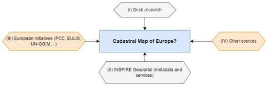
Figure 1.
Research methodology.
2. Cadastral Parcels in INSPIRE
2.1. INSPIRE Overview
The legal framework of INSPIRE has been set by the Directive (2007/2/EC) and interdependent legal acts, which are called implementing rules, in the form of Commission regulations and decisions [25]. By design, the infrastructure itself is built upon the SDIs established and operated by European Union member states that are then made compliant with the implementing rules, covering its core components: metadata, network services, interoperability of spatial datasets and services, data sharing and monitoring and reporting, together with the obligation to establish a national coordination body.
The implementing rules for metadata, the interoperability of data themes, the network services (that help to share the ‘infrastructure’s content online) and the data sharing are complemented by non-legally binding technical guidance documents. These guidelines are in line with well-established international standards, mainly developed by the Open Geospatial Consortium (OGC) [29]. They explain a possible technical approach for implementing the legal requirements and embed additional recommendations that may help data providers in their implementation for a range of use cases [30]. The thematic scope of INSPIRE includes 34 cross-sectoral categories, named data themes (Figure 2), listed in the three annexes of the Directive and reflecting two main types of data: spatial reference data (presented in Annex I and partly in Annex II), which define a location reference that the remaining themes (in Annex III and partly in Annex II) can then refer to.
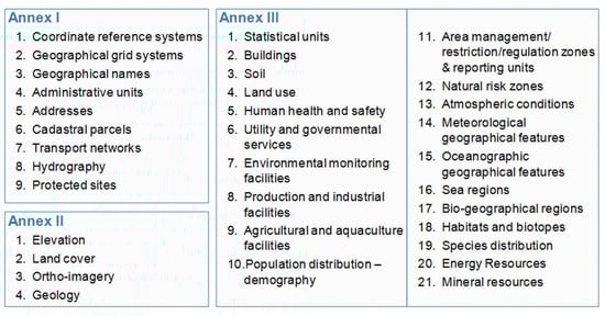
Figure 2.
INSPIRE themes, organised in three annexes. Source: INSPIRE Directive.
Data, functionality and metadata are shared through web-based services, referred to as Network Services [31], based on a Service Oriented Architecture (SOA) approach (Figure 3).
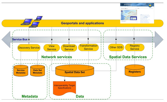
Figure 3.
Distributed Service Oriented Architecture of INSPIRE. Source: European Commission, Joint Research Centre.
The entry point to the INSPIRE infrastructure is the INSPIRE Geoportal [32]. It serves as a central access point to the data and services from public organisations in the EU MS and European Free Trade Association (EFTA) countries, which fall under the scope of INSPIRE. The INSPIRE Geoportal enables cross-border data discovery, access, visualisation and download. It does not store any geospatial data, but it simply acts as the main client application of the whole INSPIRE infrastructure by exposing data through the harvesting of the Catalogue Service for the Web (CSW) endpoints made available by Member States. Alongside the INSPIRE Geoportal, which is operated by the European Commission (EC), there are also national geoportals operated by single countries. Links to national geoportals are available in the INSPIRE Knowledge Base (IKB) section entitled INSPIRE in your country.
INSPIRE implementation is officially monitored through the monitoring and reporting mechanism [33]. It is an annual process whose results are published by 31 March each year, at the latest, with reference to the status of the implementation of the infrastructure on 15 December of the preceding year. Monitoring is performed through a set of indicators that are calculated based on the metadata collected from MS and EFTA countries’ public authorities. These indicators measure the implementation progress of the Directive and are used to evaluate the success against its objectives. The cadastral parcels data theme is included in Annex I, which means that it is considered as reference data, i.e., data that constitute the spatial frame for linking and/or pointing at other information that belongs to specific thematic fields such as environment, soil, land use, and many others. As much as possible, in the INSPIRE context, cadastral parcels should form a partition of the national territory. The cadastral parcel should be considered as a single area of Earth’s surface (land and/or water), national law under homogeneous property rights and unique ownership, property rights and ownership being defined by national law (adapted from UN ECE 2004 and WG-CPI, 2006) [34].
INSPIRE does not aim at harmonising the concepts of ownership and rights related to the parcels, but focuses on the geometrical aspects as presented in the national systems of the countries. Cadastral parcels are considered in the INSPIRE scope if they are available as vector data.
The data relating to the cadastral parcels is of wide use in all the phases of policy making. By enabling the link with the parcel owner, the theme makes it possible to know if the land is public or private: this is key information for deciders, as the means of action may be quite different according to the land ownership status. It also makes it possible for any government to manage its public land (e.g., by acquiring new parcels for a project), organise land consolidation, improve agriculture, find owners for targeted communication (e.g., to encourage them to perform some actions, such as better isolation of buildings located on the parcel in order to save energy and to make the buildings less vulnerable to risk), to check if a permit claimant is the parcel owner or to find the owner of a polluting parcel.
The cadastral parcel data also helps to understand the landscape, e.g., by analysing the size and distribution of land property. It is also quite useful in the European Common Agriculture Policy context, as cadastral parcels may be used to define the eligible area for subventions. A background cadastral map is necessary to prepare land planning and also to display regulated areas and, so, to make everyone aware of the public restrictions that apply to a property.
2.2. Cadastral Parcels Availability and Accessibility
INSPIRE Geoportal provides access to a wide range of geospatial data, including cadastral parcel datasets provided by EU and EFTA countries. It is possible to search cadastral parcel data based on country, theme, or other criteria and access relevant metadata and download links. Geoportal offers a range of data formats and may include INSPIRE conformant and non-conformant datasets. To assess the availability and accessibility of data, we followed the quantitative indicators used in INSPIRE monitoring and reporting. These values refer to the ability to find (metadata), access, view and/or download data directly from the INSPIRE Geoportal. The research was performed for 27 EU MS and 5 EFTA countries (Figure 4) during the week from 17 April to 24 April 2023. The total numbers of metadata records (129), downloadable datasets (47), and viewable datasets (59) found for the cadastral data theme are shown on the right side of Figure 3, while an overview for each MS and EFTA country is provided at the bottom. Clicking on a particular country provides a more detailed overview of that specific country.
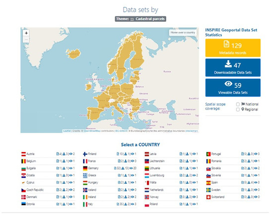
Figure 4.
Available cadastral parcel datasets in EU MS and EFTA countries. Source: INSPIRE Geoportal, European Commission, Joint Research Centre.
A set of indicators (Table 1), calculated based on collected data, address spatial data identification through the metadata. This approach enables documented spatial data to be available through online services for finding, viewing and downloading. For the purpose of our research, we focused on indicators related to the availability and accessibility of spatial datasets through view and download services for cadastral parcel data. Namely, we chose the following indicators [33]:

Table 1.
Indicators of availability and accessibility for cadastral parcels.
- DSi1.1—the number of spatial datasets for which metadata exists. The indicator represents the amount of all dataset metadata records published by MS and EFTA countries through their discovery services;
- DSi1.2—the number of spatial data services for which metadata exists. This is the number of spatial data services published by MS and EFTA countries through their discovery services;
- DSi1.4—the number of spatial datasets that cover the regional territory. This is the number of spatial dataset metadata records that contain the keyword “Regional”;
- DSi1.5—the number of spatial datasets that cover the national territory. This is the number of spatial dataset metadata records that contain the keyword “National”;
- NSi2.1—indicators representing the percentage of spatial data sets available through viewing services. These indicators are calculated using DSi1.1 data and the viewing data set;
- NSi2.2—indicators representing the percentage of spatial data sets available through downloading services. These indicators are calculated using DSi1.1 data and the downloading data set.
For the abbreviated country names, we use standard ISO Alpha 2 codes [35].
The overall number of spatial data sets for which metadata exists (DSi1.1) is 129 records. Although most countries have one or two metadata records, there are significant deviations for some countries. For example, Germany with 32, Finland with 13 and Italy with 35 metadata records. On the other side, Switzerland has no available metadata related to the cadastral parcels. Taking this into account, we see that the three mentioned countries with a total number of 90 metadata records have more than 62% of the total available metadata records (Figure 5). The reason is the provision of more regional data instead of one national data set.
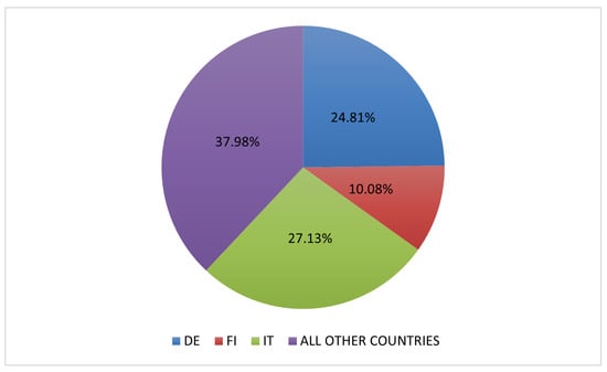
Figure 5.
Metadata records for cadastral data.
If we consider other countries, their total number of metadata is 49 (37.98%), as shown together in Figure 5. Most countries have only one set of metadata (e.g., Belgium, Bulgaria, Cyprus, etc.) or two sets (e.g., Czech Republic, France, Hungary, etc.). A few countries stand out with slightly more sets of metadata: Austria (4), Spain and Portugal (5), and Norway (3). On the other hand, Switzerland is without a single set of data.
It is significantly different when analysing the indicator (DSi1.2), the number of spatial data services for which metadata exists. Here, apart from Germany, with 33 spatial data services, no other country significantly deviates. The only country that does not have any kind of cadastral data available within the INSPIRE is Switzerland. However, despite being an EFTA member, Switzerland is not a member of the EU and, therefore, not bound by the regulations and directives of the EU, including INSPIRE. Each country has its own specific approach to implementing and enforcing spatial regulations related to INSPIRE. While the EFTA countries are not members of the EU, they have adopted and implemented certain aspects of the INSPIRE Directive through bilateral agreements or domestic regulations. Unlike Switzerland, the other three EFTA countries have already displayed available data sets on the Geoportal, although only Norway actually provides access to data via the WFS service.
If we consider the organisation of the data on a country level, it is noticeable that three countries have most of the cadastral data at the regional level, Germany, Finland and Italy (Figure 6). This is in line with the number of metadata records. Germany has 29 spatial data spatial datasets that cover regional territory and zero that cover national territory, Finland has nine datasets that cover regional and one that covers national territory and Italy has thirty-two on the regional and two on the national level. Germany, Finland and Italy have a decentralised approach to cadastral data management. Cadastral information is primarily organised and managed at the regional, state or administrative level rather than at the national level. Each of the 16 federal states in Germany and several administrative regions in Finland and Italy has its own cadastral authorities responsible for maintaining and providing access to cadastral data within their respective jurisdictions. This regional approach allows for greater flexibility and adaptation to local needs and regulations.
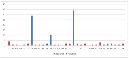
Figure 6.
Relationship between regional and national cadastral data sets.
By analysing spatial data sets covering regional (DSi1.4) and national territory (DSi1.5), we can observe that this is the underlying reason for the variation in the number of data sets among these three countries compared to the others. Almost all other countries have based provision of their cadastral data sets on the national level (Spain, Portugal and Romania have one data set on a national level and one on a regional level). When examining the datasets at the national level, we observe that no country deviates significantly. However, some countries do not provide cadastral data on the national level, as already stated. As for the NSi2.1 and NSi2.2 indicators, Figure 7 shows a high percentage in most of the countries. As for the indicators representing the percentage of spatial data sets available through viewing services (NSi2.1) and downloading services (NSi2.2), Figure 4 shows the high percentage in most of the countries. Two countries that have data at the regional level should be singled out: Finland, with 7.69%, and Italy, with 8.57%. The three countries with indicator values of zero have different starting points. Switzerland does not provide any cadastral data, while Sweden and France only provide metadata.
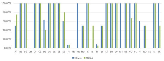
Figure 7.
Indicators representing the percentage of spatial data sets available through viewing services (NSi2.1) and downloading (NSi2.2) services.
During the aforementioned period of data collection, we also investigated for each country whether the data are really accessible. In order to perform it, we used QGIS software to connect to the services or open downloaded data. Figure 8 displays the countries (highlighted in green) for which we were able to access and download the data (Austria, Denmark) or where the data were available through various network services such as OGC WMS (Web Map Service) for view and OGC WFS (Web Feature Service) for download. This group includes Greece, Finland, Bulgaria, etc. INSPIRE data are mostly harmonised at the European level, but the specific implementation and availability of cadastral data as WMS and WFS services can vary depending on the specific countries and regions and also the data provider.
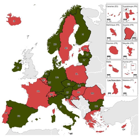
Figure 8.
Countries (green) with access to cadastral data and countries (red) without access.
Countries for which we could not access the data are marked in red. Although Figure 8 shows a significant proportion of countries (15) where data were unavailable, there are considerable variations in the reasons for that. Only five countries declared that they do not have data to download (Switzerland, France, Malta, Portugal and Sweden), while in Croatia, data download is unavailable for the general public. It is important to mention that countries like Belgium, Estonia, Greece, Hungary, Poland, and Romania only allow the download of data for a single cadastral parcel for example. Our assumption is that complete data can be obtained upon request and under certain conditions connected with the registration or the data distributed by non-compliant local government units. For example, in Poland, the SDI implementation is delayed by the economic disparities between Polish regions and the existence of hundreds of county databases that publish cadastral data via network services such as the WMS and the WFS, which are not always fully compliant with EU standards [18]. Some countries, like Cyprus and Iceland, have non-functional services. We assume that the link to services may have been changed in the meantime since the time links were placed on the INSPIRE Geoportal. New updated links have not been inserted. So, when accessing public cadastral parcel data, it is important to check the terms of use, licensing, and any restrictions associated with the data sets.
In general, the availability and accessibility of cadastral data for free use can be influenced by several factors, including national regulations, data licensing and protection. Each country has its own regulations governing the use and dissemination of geospatial data, including cadastral data. These regulations may impose restrictions on the distribution and usage of the data, which can impact its availability for free usage. Also, Cadastral data may be subject to specific licensing agreements, even within the framework of INSPIRE. Licensing conditions can vary between countries, and certain datasets may require users to acquire licenses or pay fees to access or use the data. Data sometimes contain sensitive information about property ownership and boundaries. To comply with data protection and privacy regulations, countries may impose restrictions on the availability or use of certain attributes or datasets, limiting free access to such data. Cadastral data requires ongoing maintenance and updates, which incur costs. In some cases, the costs associated with data collection, management, and maintenance may be recovered through user fees or licensing arrangements. In addition to the irregular maintenance of links, the stated reasons have greatly affected cadastral data unavailability in the EU and EFTA countries.
3. Other Related Initiatives in Europe
3.1. PCC
The Permanent Committee on Cadastre in the European Union (PCC) was established in October 2002 with the main objectives:
- To constitute a network of information on cadastre to facilitate the exchange of information, expertise and best practices among the members of the PCC;
- To represent a privileged link between cadastral institutions and the organs of the European Union and other entities requiring cadastral information to carry out their activities.
The PCC mission is to create an adequate space in which to promote the full awareness of the activities developed by the European Union, and the Member States related to cadastre and, by means of this information, to develop strategies and propose common initiatives with the aim of achieving greater coordination among the different European cadastral systems and their users. The permanent secretariat is currently the responsibility of the cadastre of Romania [23].
3.2. EULIS
The European Land Information Service (EULIS) provides access to land and property information across Europe to meet the needs of professional users—lenders, conveyancers and other professional groups [24]. EULIS is a live service officially launched in November 2006 at the Annual EMF (European Mortgage Federation) conference in Brussels. Since March 2011 EULIS is owned and governed by a European Economic Interest Group (EEIG) with members from different member countries, each responsible for land and property information in its own country.
More than 20 countries (not all EU-member countries) are involved in EULIS. Its aim is to provide easy worldwide access to European land and property information in order to underpin a single European property market. The technical infrastructure of EULIS facilitates the goal of giving users seamless access to land register information across borders if they have the right agreement with their local land register for online access. The main focus of EULIS is on property information, and not so much on the geometry of the cadastral parcel.
3.3. UN-GGIM: Europe
The United Nations Economic and Social Council (ECOSOC) established the United Nations Committee of Experts on Global Geospatial Information Management (UN-GGIM) in 2011, aiming to promote international cooperation in the field of global geospatial information. UN-GGIM was established as the intergovernmental mechanism for making joint decisions and setting directions with regard to the production, availability, and application of geospatial information within national, regional, and global policy frameworks [36]. An important strategic document related to geospatial information management at various levels is the United Nations Integrated Geospatial Information Framework (UN-IGIF), which provides a basis and guide for developing, integrating, strengthening and maximising geospatial information management and related resources in all countries. The IGIF focuses on location information that is integrated with any other meaningful data to contribute to the nation’s development priorities and the SDGs [19]. Particular attention has been given to the land-related geospatial information infrastructure, which is reflected in the Framework for Effective Land Administration (FELA) [21]. FELA seeks to provide the reference and guidance for UN Member States when establishing, strengthening, coordinating and monitoring their land administration. FELA aligns directly with the overarching and strategic Integrated Geospatial Information Framework (IGIF), which implements the IGIF for the land sector.
The UN-GGIM: Europe is one of the regional entities of the global UN-GGIM initiative and was officially established on 1 October 2014 [37]. To achieve its objectives, UN-GGIM: Europe has prepared a work plan that, among other issues, addresses the needs of users of geospatial information for data interoperability and harmonisation. The Executive Committee, therefore, decided to establish the working group on Core Data (Working Group A) with the goal of defining a set of core data themes for Europe that should be harmonised between countries and that are particularly relevant for monitoring and achieving the SDGs. UN-GGIM: Europe Core Data themes are identical to INSPIRE data themes and build on the INSPIRE data specifications. The working group has selected 14 INSPIRE themes as core data. One of them is cadastral parcels. As such, cadastral and land registration systems play a major social and economic role and are necessary to achieve most of the SDGs.
The definition of cadastral parcels has been undertaken from INSPIRE and the recommendation for UN Member States is to provide cadastral parcels in line with INSPIRE principles.
3.4. Recent Policy Initiatives
The European Union was established with the main idea of common market space and free circulation of people and goods as a prerequisite to a larger economy. Today’s numbers show the European Union achieved its plan, being placed as the 3rd strongest economy in the world (by the World Bank list for 2022), after China and USA when being observed as one common body and market, not as separate countries of which it consists.
We are currently living in an accelerated period regarding the digitalisation of data, products and services. Therefore, the European Commission published the Data Strategy and the White Paper on Artificial Intelligence [38] as the fundamental acts of the new digital European strategy. The European Strategy of Data lies on the same course as the idea of the European Union, but regarding data: with a common European data space, a single market for data would be established, enabling data flow within the EU and across different sectors. A greater but unique market for data, bound with clear European rules, values, and mechanisms, would support the creation and innovation process of more available and quicker to achieve high-quality data. The European single market’s advantage is its global reach and competitiveness.
The European Data Strategy was initiated in 2020 with the Data Governance Act adopted in May 2022 (Regulation EU 2022/868), but will be applicable from September 2023 and with the Data Act from February 2022. The Data Governance Act is adopted in order to support the set-up and development of common European data spaces [39] in strategic domains regarding different sectors involving both private and public stakeholders, while the Data Act clarifies who can create value from the data. The most powerful impact of the Data Governance Act is the framework it provides for voluntary data sharing, shielded and regulated with trustworthy mechanisms so the data can be shared for the overall benefit of businesses and citizens, making the economy and society grow based on the new values created from the reuse of the data. Data sharing is not a new concept, but has still not been exploited to the maximum since the trust mechanisms were not clearly set, and society did not have a high level of trust in data sharing, consequently preventing benefiting from the enormous potential of the data. To release the data among all interested parties, strong and truthful mechanisms for the reuse of the protected data must be clearly set and regulated, and the sharing has to be encouraged. That is the fundamental idea of the Data Governance Act, which would enable more data to be available and shared with confidence in order to be re-used with care. It is achieved through the public sector’s data sharing, data intermediation services and data altruism organisation, all sharing data under a trustful framework. The European Data Strategy is closely linked to other EU initiatives, such as the Digital Single Market, the European AI Strategy, and the European Green Deal. It sets out a long-term vision for Europe’s data-driven future, highlighting the potential economic and societal benefits that can be achieved through responsible and innovative use of data. The Data Act, on the other hand, is the document that proposes harmonic rules for fair access and use of data [39].
Furthermore, the Directive of the European Union that sets up common rules for open data and the re-use of public sector information entered into force in 2019 under the name Open Data Directive (EU 2019/1024). The new Directive replaces the former Public Sector Information Directive and puts into priority the release of public sector data in free and open formats. The idea of this Directive corresponds to the European Data Strategy concerning the possibility of re-use of public sector data ensuring fair competition [40] and easy public cross-border sector information and innovations based on such shared data. The main goal of Open Data Directive is that the non-personal data should be open by default and designed in open formats and to open standards, embracing the re-use of publicly funded research data and free reuse as a principle. This Open Data Directive makes a path to all public data being released for every individual request for re-usage making space for the strengthening of the EU’s data economy in all sectors.
A high-value dataset refers to a dataset that is considered particularly valuable due to its potential for driving innovation, public benefits, and economic growth. These datasets typically possess characteristics such as uniqueness, relevance, and potential societal impact. While the specific definition may vary across jurisdictions and organisations, the concept revolves around identifying and making available datasets with substantial value and utility. The European Union’s Open Data Directive encourages Member States to identify and publish high-value datasets as part of their open data initiatives. The Directive suggests that high-value datasets could include data related to geospatial information, earth observation data, statistical data, company and trade registers, and transport data, among others. These datasets have the potential to spur innovation, improve decision-making processes, and create new services and applications. However, it is worth noting that the identification and availability of high-value datasets can vary depending on the data practices and policies of different organisations and governments. Open data initiatives and data portals, both at the national and regional levels, often provide access to such datasets, allowing users to explore, analyse, and utilise them for various purposes.
On 20 January 2023, the European Commission published Commission Implementing Regulation (EU) 2023/138 of 21 December 2022, establishing a list of special high-value data sets and the publication and re-use modalities. This Implementing Regulation contains a list of high-value data sets that public authorities will have to make available for re-use free of charge within 16 months. The Act is an implementation decision following up the Directive on open data, and the re-use of public sector information replaces and enhances the ’PSI Directive’ (2003/98/EC). The high-value data list includes a large number of data sets that are part of INSPIRE topics; that is, certain INSPIRE data sets are also high-value data sets. Out of a total of 34 INSPIRE themes of spatial data, at least 24 of them belong to high-value data sets. The implementing regulation was adopted in accordance with the Open Data Directive, which defines six categories of such high-value datasets:
- Geospatial data;
- Data on observing the Earth and the environment;
- Meteorological data;
- Statistics;
- Trading companies and ownership of trading companies;
- Mobility
Following the European Digital Strategy, the datasets will have to be available in a machine-readable format, via an Application Programming Interface and, where relevant, as a bulk download. For entities whose data sets belong to high-value data sets and are already part of NSDI/INSPIRE, this should mean that the majority of requirements and conditions on data prescribed by Commission Implementing Regulation 2023/138 and Directive 2019/1024 have already been fulfilled: such as describing metadata and developing download services considered as APIs in the context of the aforementioned legislation. For such data sets, requirements on the terms of use through an open license have to be defined. Also, through metadata, there should be placed an indication that the data set is a high-value set.
In Annex I of the Commission Implementing Regulation EU 2023/138, all six categories of high-value datasets mentioned previously are described in detail. In the first dataset, the geospatial thematic category includes datasets within the scope of the INSPIRE data themes Administrative units, Geographical names, Addresses, Buildings and Cadastral parcels as defined in Annex I and Annex III to Directive 2007/2/EC of the European Parliament and of the Council. The direct implication of the Annex of the latest Commission Implementing Regulation EU 2023/138 declares Cadastral Parcels as a dataset of high value.
4. Discussion
There are many initiatives that look for easy and simple access to cadastral data. The reason is the importance of cadastral data in various use cases, e.g., land management and land transactions, risk and disaster management, real property market, taxation, land information system for agricultural subsidies (LPIS), land reforms, infrastructure management, spatial planning, protection of soil and water, statistics, etc. In all these use cases, cadastral data with cadastral maps are necessary and irreplaceable. Incorporating cadastral data into the INSPIRE framework enables the sharing, interoperability and integration of cadastral information in different domains and sectors. It promotes efficient land administration, spatial planning and sustainable practices.
The establishment of the PCC and EULIS triggered discussions about the need for available and accessible cadastral data. This need was clearly recognised and properly tackled by the legally bound INSPIRE Directive. The INSPIRE Roadmap officially finished in 2021, but we found in our analysis that the cadastral data are still not fully available and accessible in the infrastructure. It is also evident for other data themes [41]. Many countries already provide cadastral data, but there is still work to be carried out in some countries. The cadastral map of Europe at the moment is rather a puzzle where still some pieces are missing. The lack of available and/or easy-to-use data sets also impacts the availability of end-user applications that satisfy the information needs of users and offer a low-threshold access for a larger public to this European spatial data infrastructure. The reasons for this state could be found in a number of factors:
- Each country has its own policies and regulations regarding the dissemination of spatial data, including cadastral data,
- Some countries have stricter regulations or legal constraints on making cadastral data of data publicly available,
- Some countries consider that property rights associated with cadastral data necessitate careful sharing of both the cadastral data itself and the data sets associated with it,
- Some countries do not have the necessary infrastructure to ensure data quality and upgrade datasets,
- Cadastral data are often managed by multiple stakeholders, including government agencies, municipalities, or private entities. Ensuring collaboration, data sharing agreements, and obtaining consent from all relevant data custodians and integration can be difficult.
The inclusion of cadastral data in the UN GGIM: Europe core data sets will for sure help in that direction. Also, new policy initiatives, namely, open data directives and regulations on high-value datasets, provide new momentum for the availability and accessibility of cadastral and other spatial data. The political and legislative context in Europe, combined with the pace of technological developments and the diversification of data sources, create excellent conditions for the evolution of SDIs [42].
The importance of cadastres lies in their ability to provide accurate, up-to-date, and accessible information about land ownership, boundaries, and related attributes. They underpin land governance, property rights, economic activities, infrastructure development, and sustainable resource management, contributing to social stability, economic prosperity, and environmental sustainability. So placing the cadastral parcels among the high-value datasets triggers long-term benefits for the socio-economic rate; standardisation and interoperability of pan-European cadastral parcel data would enable the establishment of common standards and formats. It would promote interoperability among different national cadastres, facilitating data integration, exchange, and analysis across borders.
Standardisation would simplify cross-border transactions, investments, and collaborations involving land and property. Furthermore, the establishment of pan-European cadastral parcel dataset would support cross-border land management and planning, with a comprehensive and unified view of land ownership, boundaries, and land use patterns across multiple countries. This would facilitate joint initiatives for transboundary land management, infrastructure development, and environmental conservation. Access to a unified dataset of cadastral parcels would enhance decision-making processes at the European level by supporting policy-makers, urban planners, and researchers with valuable insights into land-related trends, patterns, and challenges. It would also increase investor confidence and support the integration of real estate markets across countries. And finally, within the recent natural disasters more often occurring due to global warming, the common pan-European dataset of cadastral parcels would increase and support the environmental monitoring and conservation efforts at a European scale with the identification and analysis of land use patterns, land degradation, and changes in land cover across borders supporting sustainable land management, biodiversity conservation, and the protection of sensitive ecological areas. The pan-European cadastral dataset would foster standardisation, enhance cross-border land management, support decision-making, boost investor confidence, promote market integration, facilitate infrastructure development, enable environmental monitoring, and foster research and innovation. It would contribute to a more efficient, transparent, and sustainable land governance framework across Europe.
The INSPIRE initiative has played a significant role in supporting cadastral unification at the European level by promoting the harmonisation, integration, and interoperability of spatial data across Member States. While INSPIRE does not specifically focus on cadastral data, its principles and framework have facilitated the exchange and sharing of cadastral information among European countries, making the first steps toward today’s efficient conduction of high-value datasets. And while INSPIRE provides a framework for harmonising and sharing spatial data, including cadastral data, the cadastral unification at the European level also relies on the willingness and efforts of individual countries to align their cadastral systems, policies, and practices. National cadastral agencies and governments play a crucial role in implementing the necessary reforms and initiatives to support the unification process.
Accordingly, regarding recent policies given in Section 3.4, it is important to highlight that while the Open Data Directive sets a common framework for open data practices across the EU, the specific implementation and enforcement may vary between Member States. Therefore, the data shared by each Member State on INSPIRE Geoportal should be continuously updated with respect to the Open Directive’s implementation according to the national level.
While the unification of cadastral datasets on a European level offers numerous benefits, there are also challenges and potential drawbacks to consider. Cadastral systems in different European countries have evolved independently and vary in terms of data structures, legal frameworks, and administrative practices. Unifying these datasets requires addressing the heterogeneity and complexity resulting from these differences. It can be challenging to harmonise cadastral data models, standards, and terminology across countries with diverse systems and historical contexts. Furthermore, each country has its own legal and administrative frameworks governing land ownership, property rights, and cadastral operations. Differences in legislation, privacy regulations, and data protection laws may pose challenges to cross-border sharing and integration of cadastral datasets. Also, cadastral datasets may vary in terms of data quality, accuracy, and completeness. Unifying datasets from different countries may require addressing discrepancies, resolving inconsistencies, and ensuring data integrity. Differences in surveying methods, cadastral maintenance practices, and data updating cycles can affect the accuracy and compatibility of cadastral information. The establishment of pan-European cadastral unification requires strong coordination, governance mechanisms, and policy alignment among participating countries. These cons are not insurmountable obstacles, and many of these challenges are being addressed through initiatives like INSPIRE and ongoing collaborations among European countries. By recognising these challenges and actively working towards their resolution, the unification of cadastral datasets can contribute to improved land governance, cross-border cooperation, and sustainable development across Europe.
5. Conclusions
Cadastral data are among many other different spatial data sets of great importance for our land and land management. The usage of cadastral data is recognised and evident in many use cases on the pan-European scale. In this paper, we provided an overview of different initiatives for cadastral data in Europe. The main focus was on INSPIRE as a main driver for the creation of the European spatial data infrastructure in the last 15 years. We used INSPIRE Geoportal to dive into the infrastructure and analyse cadastral data availability and accessibility in the EU and EFTA countries. The result of the analysis shows that the work is still not finished. Despite INSPIRE and other initiatives, it seems that, at the moment, it is still not possible to quickly and simply create a cadastral map of Europe.
The INSPIRE implementation is a gradual and continuous process. Data on the Geoportal are constantly changing over time as countries update their data sets and harmonise them with INSPIRE requirements.
However, the recognition of cadastral data as a core data set by UN GGIM: Europe and as a high-value data set in the recent European policies awakens hope and optimism that the cadastral data will be open and available in years to come. If all countries implement INSPIRE according to its requirements, it would enable data-sharing services (WMS, WFS, APIs) from all European countries to work together in an interoperable way. In addition, with the FAIR (Findability, Accessibility, Interoperability, Reusability) guiding principles [5], it would be fairly straightforward to produce the necessary European-wide geospatial data sets, including cadastral ones. Ultimately, it would enable the possibility of building a cadastral map of Europe.
Below, we outline several outstanding issues that fall outside the scope of this paper but require further attention.
- Edge Matching; In order to create a seamless cadastral map of Europe, it will be necessary to find corresponding disjoined features along the bordering edges of adjacent line datasets between different countries and properly connect them.
- Semantic Interoperability; It is a requirement not only for cadastral data to be shared between different systems or applications, but for them to be understood. This aspect should be covered through INSPIRE, but needs further investigation.
- Heterogeneity and Complexity; Cadastral systems in different European countries have evolved independently and vary in terms of data structures, legal frameworks, and administrative practices. It can be challenging to harmonise cadastral data models, standards, and terminology across countries with diverse systems and historical contexts.
- Data Quality and Accuracy; Unifying datasets from different countries may require addressing discrepancies, resolving inconsistencies, and ensuring data integrity.
- Technical Harmonisation; Integrating and sharing cadastral datasets at a European level includes establishing interoperability between different cadastral systems, ensuring data compatibility and harmonisation, and addressing issues related to data storage, data transfer, and system compatibility. Technical infrastructure, data governance, and IT capabilities need to be considered and aligned for successful unification.
- Governance and Policy Alignment; Agreement on common standards, data-sharing protocols, and decision-making processes can be time-consuming and require negotiation among multiple stakeholders, potentially resulting in delays and complexities.
- Political and Administrative Will; it may require significant investments in resources, infrastructure, and capacity building. Ensuring consistent long-term support and commitment from all involved parties can be challenging.
While INSPIRE has made significant contributions to the harmonisation and sharing of spatial data, including cadastral information, there are several challenges that it did not fully address in creating a pan-European cadastre. They are mainly related to legal and institutional differences (each country has its own legal framework, administrative structures, and property rights regimes, which can hinder the seamless integration of cadastral datasets across borders), data governance and sharing agreements. INSPIRE promotes data sharing and interoperability but does not establish specific data governance and sharing agreements for cadastral datasets; funding and resources: creating a pan-European cadastre requires significant financial investments in data infrastructure, capacity building, data integration, and system interoperability. While INSPIRE has laid the foundation for the exchange and harmonisation of spatial data, including cadastral information, these additional challenges highlight the complexities involved in creating a pan-European cadastre. Addressing these challenges would require concerted efforts, policy reforms, and sustained collaboration among European countries with the goal of achieving a comprehensive and integrated cadastre system at the European level. This paper reviewed the latest new policies and regulations that have created an additional support for the future pan-European cadastre. However, regarding our comments given in the discussion section, the pan-European cadastre is still not possible to establish at the moment, but we are significantly moving towards it.
6. Suggestions and Future Research
National governance in EU countries should focus on policy alignment and harmonisation, capacity building, data quality assurance, stakeholder engagement, and international collaboration. Governments should prioritise the alignment of land administration policies and legal frameworks to ensure compatibility and harmonisation across EU countries. They should invest in capacity-building initiatives to enhance technical expertise and capabilities in cadastral agencies and land registries. Data quality assurance processes should be established to ensure accurate and reliable cadastral information. Stakeholder engagement strategies should be developed to foster collaboration and inclusivity. Nevertheless, also international collaboration and knowledge exchange should be promoted to share best practices and lessons learned in cadastral development to excel in the development of a unique border-less cadastre.
As for future research in the field of creating a pan-European cadastre it should explore various areas to address existing challenges and advance the development of an integrated system. The following potential research areas warrant investigation of legal and policy framework, sharing models of data governance, data integration and interoperability, quality assurance and data updating, stakeholder engagement, user needs and applications. Regarding legal and policy Frameworks future research should focus on analysing and comparing the legal and policy frameworks associated with land administration, property rights, and cadastral systems across different European countries. Such analysis can identify key legal barriers and challenges pertaining to the harmonisation of cadastral data and provide recommendations for necessary legal reforms that facilitate cross-border integration. As for the data governance and sharing models, research efforts should investigate diverse data governance models and sharing mechanisms applicable to cadastral data at a pan-European level. It should entail examining data access and sharing agreements, privacy protection mechanisms, and data security protocols. Novel approaches balancing the need for data openness and transparency with privacy and security considerations should be explored. Regarding data integration and interoperability subsequent research should concentrate on the technical aspects of data integration and interoperability among cadastral datasets, which would include exploring harmonised data models, standards, and formats that enable seamless data exchange and integration. Additionally, investigating technologies such as distributed ledger technologies (e.g., blockchain) for secure and transparent cross-border data sharing can be beneficial. Furthermore, regarding quality assurance and data updating future research should address challenges associated with data quality, accuracy, and the updating of cadastral datasets, which involves developing methodologies and frameworks for continuous data quality assessment, data validation, and maintenance procedures. Innovative approaches to integrating real-time data updates and feedback mechanisms should be investigated to ensure the timeliness and reliability of cadastral information. Last but not least, future research regarding user needs and applications should focus on comprehending the user needs and requirements for a pan-European cadastre, which entails identifying potential applications and value-added services that can be derived from integrated cadastral data. Engaging stakeholders, including government agencies, businesses, researchers, and citizens, to understand their specific needs and use cases is imperative. By addressing these research areas, valuable future insights can be gained, and practical solutions can be developed to overcome challenges and advance the development of a pan-European cadastre. Such research can inform policy decisions, technological advancements, and collaborative efforts to create an integrated and efficient land administration system across Europe.
Author Contributions
Conceptualization, V.C., S.Š. and O.B.O.; methodology, V.C. and S.Š.; validation, V.C., S.Š., O.B.O. and A.L.; formal analysis, V.C., S.Š. and O.B.O.; data curation, S.Š.; writing—original draft preparation, V.C., S.Š. and O.B.O.; writing—review and editing, V.C., S.Š., O.B.O. and A.L.; visualization, S.Š.; supervision, V.C. All authors have read and agreed to the published version of the manuscript.
Funding
This research received no external funding.
Data Availability Statement
The authors confirm that the data supporting the findings are available within the article and on the INSPIRE Geoportal.
Acknowledgments
This research is supported by the scientific project Digital twins and smart cities from the University North, Croatia.
Conflicts of Interest
The authors declare no conflict of interest.
References
- FAO/UNEP. The Future of Our Land: Facing the Challenge. In Guidelines for Integrated Planning for Sustainable Management of Land Resources; Publishing House: Rome, Italy, 1999. [Google Scholar]
- UN/ECE. Land Administration Guidelines With Special Reference to Countries in Transition; Publishing House: New York, NY, USA; UN: Geneva, Switzerland, 1996. [Google Scholar]
- Williamson, I.; Enemark, S.; Wallace, J.; Rajabifard, A. Land Administration for Sustainable Development; ESRI Press Academic: Redlands, CA, USA, 2010; 488p. [Google Scholar]
- ISO 19152:2012; Geographic Information–Land Administration Domain Model, Edition 1. ISO: Geneva, Switzerland, 2012; 118p.
- Transforming Our World: The 2030 Agenda for Sustainable Development. UN. Available online: https://sdgs.un.org/2030agenda (accessed on 15 June 2023).
- Lemmen, C.; Van Oosterom, P.; Bennett, R. The land administration domain model. Land Use Policy 2015, 49, 535. [Google Scholar] [CrossRef]
- Paulsson, J.; Paasch, J.M. The Land Administration Domain Model—A literature survey. Land Use Policy 2015, 49, 546–551. [Google Scholar] [CrossRef]
- Kalogianni, E.; Janečka, K.; Kalantari, M.; Dimopoulou, E.; Bydłosz, J.; Radulović, A.; Vučić, N.; Sladić, D.; Govedarica, M.; Lemmen, C.H.J.; et al. Methodology for the development of LADM country profiles. Land Use Policy 2021, 105, 105380. [Google Scholar] [CrossRef]
- Polat, Z.A.; Alkan, M.; Paulsson, J.; Paasch, J.M.; Kalogianni, E. Global scientific production on LADM-based research: A bibliometric analysis from 2012 to 2020. Land Use Policy 2022, 112, 105847. [Google Scholar] [CrossRef]
- Van Oosterom, P.; Unger, E.M.; Lemmen, C. The second themed article collection on the land administration domain model (LADM). Land Use Policy 2022, 120, 106287. [Google Scholar] [CrossRef]
- Križanović, J.; Roić, M. Development of a Methodology and Model for Land Administration Data Dissemination Processes. Land 2023, 12, 7120231. [Google Scholar] [CrossRef]
- Bennett, R.M.; Donovan, J.; Masli, E.; Riekkinen, K. Land Administration As-A-Service: Relevance, Applications, and Models. Land 2023, 12, 241. [Google Scholar] [CrossRef]
- Kaufmann, J.; Steudler, D. Cadastre 2014—A Vision for a Future Cadastral System. FIG Publication (1998). Available online: https://www.fig.net/resources/publications/figpub/cadastre2014/translation/c2014-english.pdf (accessed on 15 March 2023).
- Steudler, D. Cadastre 2014 and Beyond. FIG Publication No 61 (2014). Available online: https://www.fig.net/resources/publications/figpub/pub61/Figpub61.pdf (accessed on 15 June 2023).
- Van Oosterom, P.; Lemmen, C. The Land Administration Domain Model (LADM): Motivation, standardisation, application and further development. Land Use Policy 2015, 49, 527–534. [Google Scholar] [CrossRef]
- FIG. FIG Statement on the Cadastre. In FIG Publication No. 11; FIG: Copenhagen, Denmark, 1995. [Google Scholar]
- Pivac, D.; Roić, M.; Križanović, J.; Paar, R. Availability of Historical Cadastral Data. Land 2021, 10, 917. [Google Scholar] [CrossRef]
- Trystula, A.; Dudzińska, M.; Źróbek, R. Evaluation of the Completeness of Spatial Data Infrastructure in the Context of Cadastral Data Sharin. Land 2020, 9, 272. [Google Scholar] [CrossRef]
- United Nations Integrated Geospatial Information Framework (UN-IGIF). Available online: https://ggim.un.org/IGIF/overview/ (accessed on 11 May 2023).
- Grant, D.; Enemark, S.; Zevenbergen, J.; Mitchell, D.; McCamley, G. The Cadastral triangular model. Land Use Policy 2020, 97, 104758. [Google Scholar] [CrossRef]
- FELA. Framework for Effective Land Administration. UN-GGIM. 2020. Available online: https://ggim.un.org/meetings/GGIM-committee/10th-Session/documents/E-C.20-2020-29-Add_2-Framework-for-Effective-Land-Administration.pdf (accessed on 15 May 2023).
- Unger, E.M.; Benett, R.; Crompvoets, J.; Lisec, A.; Cantat, F. Advancing FELA—The framework for effective land administration. In Proceedings of the Volunteering for the Future-Geospatial Excellence for a Better Living: XXVII FIG Congress, Warsaw, Polandv, 11–15 September 2022; Available online: https://www.fig.net/resources/proceedings/fig_proceedings/fig2022/papers/ts02a/TS02A_unger_crompvoets_et_al_11446.pdf (accessed on 15 May 2023).
- Permanent Committee on Cadastre in the European Union. Available online: http://www.eurocadastre.org/ (accessed on 25 April 2023).
- European Land Information Service-EULIS. Available online: https://joinup.ec.europa.eu/collection/egovernment/solution/european-land-information-service-eulis/about (accessed on 2 May 2023).
- Directive 2007/2/EC of the European Parliament and of the Council of 14 March 2007 Establishing an Infrastructure for Spatial Information in the European Community (INSPIRE). Available online: http://eur-lex.europa.eu/legal-content/EN/ALL/?uri=CELEX:32007L0002 (accessed on 5 February 2023).
- Eurogeographics. Available online: https://eurogeographics.org/ (accessed on 26 April 2023).
- European Commission Implementing Regulation (EU) 2023/138 of December 21, 2022, Establishing a List of Special High-Value Data Sets and the Modalities of Their Publication and Re-Use. Available online: https://eur-lex.europa.eu/legal-content/EN/TXT/PDF/?uri=CELEX:32023R0138&qid=1675321692908&from=en (accessed on 6 February 2023).
- European Commission. Directive (EU) 2019/1024 of the European Parliament and of the Council of June 20, 2019 on Open Data and Re-Use of Public Sector Information. 2019. Available online: https://eur-lex.europa.eu/legal-content/EN/TXT/PDF/?uri=CELEX:32019L1024&from=EN (accessed on 6 February 2023).
- Open Geospatial Consortium. Available online: https://www.ogc.org/ (accessed on 25 April 2023).
- Cetl, V.; Tomas, R.; Kotsev, A.; de Lima, V.N.; Smith, R.S.; Jobst, M. Establishing Common Ground Through INSPIRE: The Legally-Driven European Spatial Data Infrastructure. In Service-Oriented Mapping. Lecture Notes in Geoinformation and Cartography; Döllner, J., Jobst, M., Schmitz, P., Eds.; Springer: Cham, Switzerland, 2019. [Google Scholar]
- Commission Regulation No 976/2009 of 19 October 2009 implementing Directive 2007/2/EC of the European Parliament and of the Council as regards the Network Services. Available online: https://eur-lex.europa.eu/legal-content/EN/ALL/?uri=CELEX%3A32009R0976 (accessed on 5 March 2023).
- Minghini, M.; Cetl, V.; Kotsev, A.; Tomas, R.; Lutz, M. INSPIRE: The Entry Point to Europe’s Big Geospatial Data Infrastructure. In Handbook of Big Geospatial Data; Werner, M., Chiang, Y.-Y., Eds.; Springer: Cham, Switzerland, 2021; pp. 619–641. [Google Scholar]
- 2007/2/EC of the European Parliament and of the Council as Regards Monitoring and Reporting. 2019. Available online: https://eur-lex.europa.eu/eli/dec_impl/2019/1372/oj (accessed on 7 March 2023).
- INSPIRE Data Specification on Cadastral Parcels–Technical Guidelines. Available online: https://inspire.ec.europa.eu/id/document/tg/cp (accessed on 6 March 2023).
- ISO–International Organization for Standardization. Available online: https://www.iso.org/ (accessed on 2 May 2023).
- UN-GGIM Mandates. Available online: https://ggim.un.org/Mandates/ (accessed on 11 May 2023).
- UN-GGIM: Europe. Available online: https://un-ggim-europe.org/ (accessed on 2 May 2023).
- European Strategy for Data. Available online: https://eur-lex.europa.eu/legal-content/EN/TXT/?uri=CELEX%3A52020DC0066 (accessed on 19 April 2023).
- Regulation (EU) 2022/868 of the European Parliament and of the Council of 30 May 2022 on European Data Governance and Amending Regulation (EU) 2018/1724 (Data Governance Act). Available online: https://eur-lex.europa.eu/legal-content/EN/TXT/?uri=CELEX%3A32022R0868 (accessed on 19 April 2023).
- Open Data Directive. Available online: https://eur-lex.europa.eu/legal-content/EN/TXT/?uri=CELEX%3A32019L1024 (accessed on 19 April 2023).
- Markovinović, D.; Cetl, V.; Šamanović, S.; Bjelotomić Oršulić, O. Availability and Accessibility of Hydrography and Hydrogeology Spatial Data in Europe through INSPIRE. Water 2022, 14, 1499. [Google Scholar] [CrossRef]
- Kotsev, A.; Minghini, M.; Tomas, R.; Cetl, V.; Lutz, M. From Spatial Data Infrastructures to Data Spaces—A Technological Perspective on the Evolution of European SDIs. ISPRS Int. J. Geo-Inf. 2020, 9, 176. [Google Scholar] [CrossRef]


Disclaimer/Publisher’s Note: The statements, opinions and data contained in all publications are solely those of the individual author(s) and contributor(s) and not of MDPI and/or the editor(s). MDPI and/or the editor(s) disclaim responsibility for any injury to people or property resulting from any ideas, methods, instructions or products referred to in the content. |
© 2023 by the authors. Licensee MDPI, Basel, Switzerland. This article is an open access article distributed under the terms and conditions of the Creative Commons Attribution (CC BY) license (https://creativecommons.org/licenses/by/4.0/).