Abstract
The coronavirus disease (COVID-19) pandemic has led to a surge in rural tourism, catering to consumers during the pandemic. However, rural tourism faces severe issues of homogeneity and environmental degradation owing to excessive development. Sustainable development of rural tourism is an urgent problem. This study, based on the average variable cost (AVC) theory, aims to explore the sustainable development of rural tourism landscapes with a focus on the Shijing area. A landscape evaluation system was established through factor analysis and weight calculations, with ten principal components contributing to a cumulative contribution rate of 77.196%. The weighted values for attractiveness, vitality, and resilience were 0.539, 0.297, and 0.164, respectively. The findings indicate that Caijiapo Village had the highest comprehensive score of 88.79 (good level of performance), whereas Laoyukou Village had the lowest comprehensive score of 80.25 (average level of performance). Caijiapo and Liyukou exhibited the strongest overall strength, whereas Liyuanpo and Xiazhuang had moderate overall strength, and Laoyukou had the weakest overall strength. The results reveal that all five villages possess rich natural landscapes and favorable geographical conditions, demonstrating the potential and attractiveness of rural tourism development. However, the overall carrying capacity was moderate and vitality was relatively weak. This supports the AVC theory application in rural tourism research and emphasizes the importance of rural landscape quality and economic vitality. The main contributions of this study are as follows: (1) the establishment of a rural tourism landscape evaluation system based on the AVC theory, providing a scientific assessment method for sustainable development; (2) the case evaluation in the Shiying area provides decision-makers with reference for development strategies; (3) emphasis on the importance of ecological conservation in rural tourism and providing recommendations to address issues of homogenization and environmental degradation.
1. Introduction
As one of the world’s most representative agricultural nations, China attaches great importance to the relationship between rural tourism and sustainable development [1,2]. Rural development is vital for national social stability and economic prosperity and is closely intertwined with the improvement of people’s living standards and the overall development of the national economy [3,4]. With social and economic advancement, rural construction has surpassed infrastructure development [5,6,7]. Rural landscapes, as crucial components of rural development, are receiving increasing attention and recognition and are accompanied by continuous development in related practices and research [8,9].
Extensive research has been conducted on the historical evolution of rural landscapes. Hannes et al. conducted a study on landscape changes in various regions of Estonia using satellite imagery and geographic information system (GIS) data to establish an index system. Over time, significant changes have occurred in the patterns of these regions, but landscape features remain largely unchanged [10,11]. However, the use of satellite imagery and GIS data alone does not accurately capture the landscape evolution process. This method is more suitable for macrolevel spatial research, whereas landscape evolution consists of microlevel changes driven primarily by small-scale spaces and forms [12,13]. A study suggested that the evolution of rural landscapes was primarily influenced by urban development, with the level of connectivity in terms of transportation, information, and economic ties between urban and rural areas being the main drivers of changes in rural landscape patterns [14]. The modernization of rural agriculture has led to the concentration of the population in certain regions and the phasing out of slower-developing agricultural villages. The rapid development of modernized rural areas has caused a decline in some small-scale villages, becoming a major factor shaping rural landscape patterns [15]. Furthermore, studies have concluded that the main factors contributing to changes in rural landscape patterns include the development of urban modernization, changes in rural economic industries, and the implementation of relevant planning policies [16,17].
Research on rural landscape planning has primarily focused on ecological conservation and recreational landscape planning. The proposed landscape planning systems have adequately incorporated ecological considerations, but it is necessary to establish management and monitoring mechanisms in the future to achieve the organic integration of landscape preservation and rural development [18,19]. Furthermore, studies have suggested classifying land based on its utility and employing different development patterns and management approaches to coordinate landscape ecological conservation with agricultural development [20,21,22,23]. Additionally, the “combination of concentration and dispersion” landscape design model emphasizes ecological integrity, advocates for multiscale landscape planning, emphasizes the synergy of different factors, and encourages public participation [24]. Some scholars argue that to enhance the quality of rural landscapes and improve the rural environment, it is necessary to go beyond individual villages and undertake comprehensive planning and protection on a larger scale to achieve sustainable rural development [25,26,27]. The evaluation system for rural landscapes has become more refined and mature, with research selecting three project levels and six indicator levels to assess aspects such as aesthetic effects, landscape integrity, and ecological carrying capacity [28]. Some scholars have used the analytic hierarchy process (AHP) in their research to evaluate the development of rural tourism in Xiangshan County, China. The research findings indicate that government support is the most important factor, followed by tourism resources and infrastructure, and finally, the tourism market [29,30].
Currently, sustainable development of rural tourism has attracted significant attention. Scholars and research institutions have been devoted to studying the sustainability of rural tourism in order to achieve a balance between the development of the tourism industry and rural communities [31,32]. Key research areas include rural tourism planning and management, community participation and cooperation, cultural preservation and heritage, resource conservation, and sustainable utilization. In terms of planning and management, research focuses on formulating development strategies and policies as well as establishing management systems to ensure sustainability [32,33]. Community participation and cooperation emphasize the involvement of local communities in decision making and resource management to enhance their sense of belonging and responsibility [34]. Cultural preservation and heritage highlight the protection of cultural heritage in rural areas to enhance tourism attractiveness and foster cultural identity among residents [35,36]. Resource conservation and sustainable utilization address the impact of rural tourism on natural resources and advocate sustainable practices to ensure long-term resource sustainability [37].
At present, rural tourism faces significant challenges, such as homogeneous competition, conservation of the natural environment, and resource utilization, demanding the formulation of plans and measures to address these issues. This study adopts average variable cost (AVC) theory to investigate the sustainable development trajectory of rural tourism landscapes, with a specific case evaluation and analysis conducted in the Shijing area. Application of this theoretical framework provides a fresh perspective and methodology for rural tourism research, breaking away from traditional research paradigms. Moreover, this study establishes a comprehensive evaluation system for assessing rural landscapes and employs weight calculations, enabling a comprehensive assessment of various elements of rural tourism landscapes. This study fills theoretical gaps in rural tourism research by adopting the AVC theory to explore the sustainable development path of rural tourism landscapes. It contributes to the field by establishing a comprehensive evaluation system and weighting calculation method for rural landscapes, providing a scientific basis for the sustainable development of rural tourism. Additionally, through a specific case evaluation analysis conducted in the Shijing area, this research addresses the lack of case studies in rural tourism sustainable development research, offering valuable insights and references for other regions.
2. Study Area and Methods
2.1. Study Area
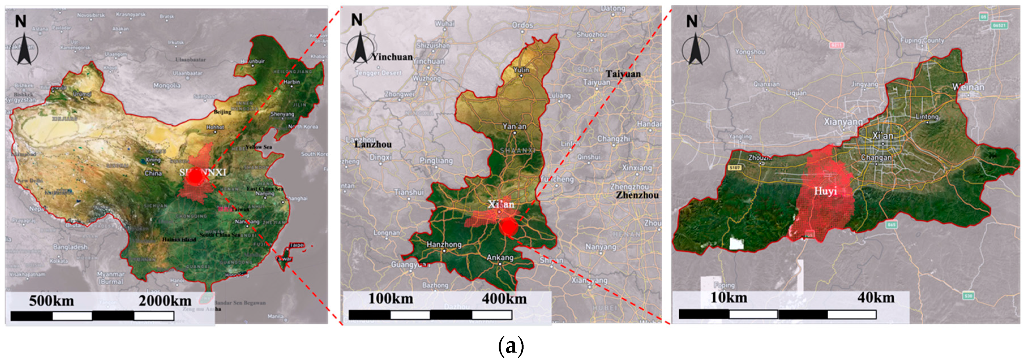
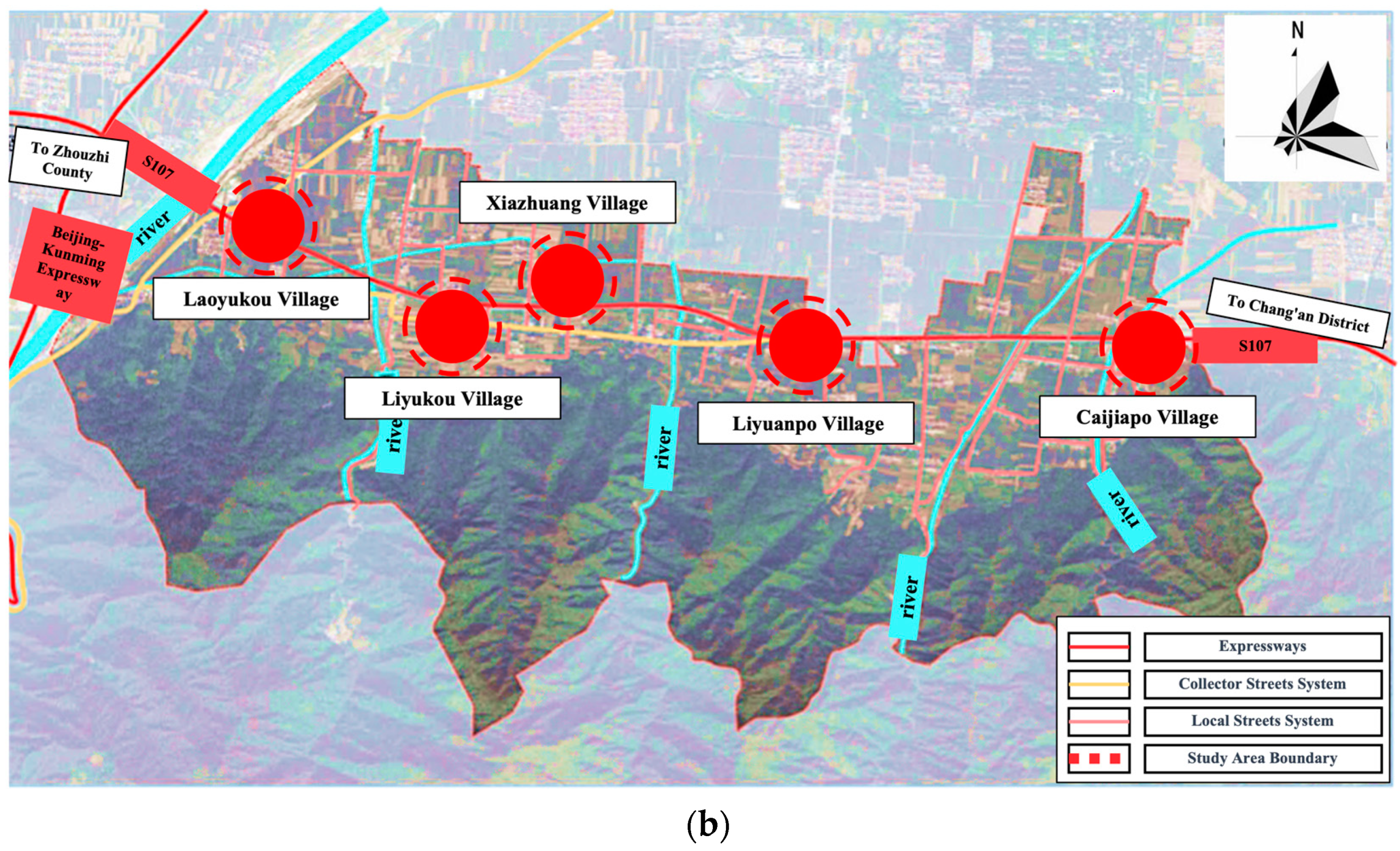
Shijing is located on Shijing Street, Huyi District, Xi’an City, Shaanxi Province, China. It is adjacent to the Qinling Mountains and bordered by the Wei River, approximately 30 km from the city center of Xi’an. The total area of this region is 1282 km2, and it is one of the three sub-centers of Xi’an, occupying a core position in Xi’an’s “one-hour economic circle” and the Guanzhong Urban Cluster. The terrain comprises three natural regions: mountainous areas, foothills, and plains. The southern Qinling Mountains area is covered with dense forest vegetation, with the highest peak, Bingjingding (Jingyu Nao), reaching an elevation of 3015.1 m and a ridge at an elevation of 680 m, whereas the lowest point in the Wei River floodplain is at an elevation of 388 m (Figure 1).

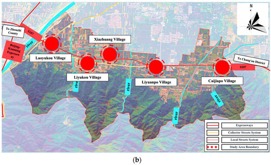
Figure 1.
Location of the Study Area. (a) The macro location of Huyi District; (b) The specific scope and location of the study area.
The climate belongs to the warm temperate continental monsoon climate zone, characterized by distinct seasons with hot summers and cold winters. The frost-free period averages 220 d/y, with an average annual precipitation of 800 mm and an average annual temperature of 13.4 °C. The Shijing Street, where the area is located, is situated 9 km southwest of the main urban area of Huyi District, covering an area of 417.63 km2. Within the Shijing area, five villages along the Huan Shan Tourist Road were selected: Caijiapo, Liyuanpo, Xiazhuang, Liyukou, and Laoyukou, with planned areas of approximately 29.84 km².
2.2. Research Framework
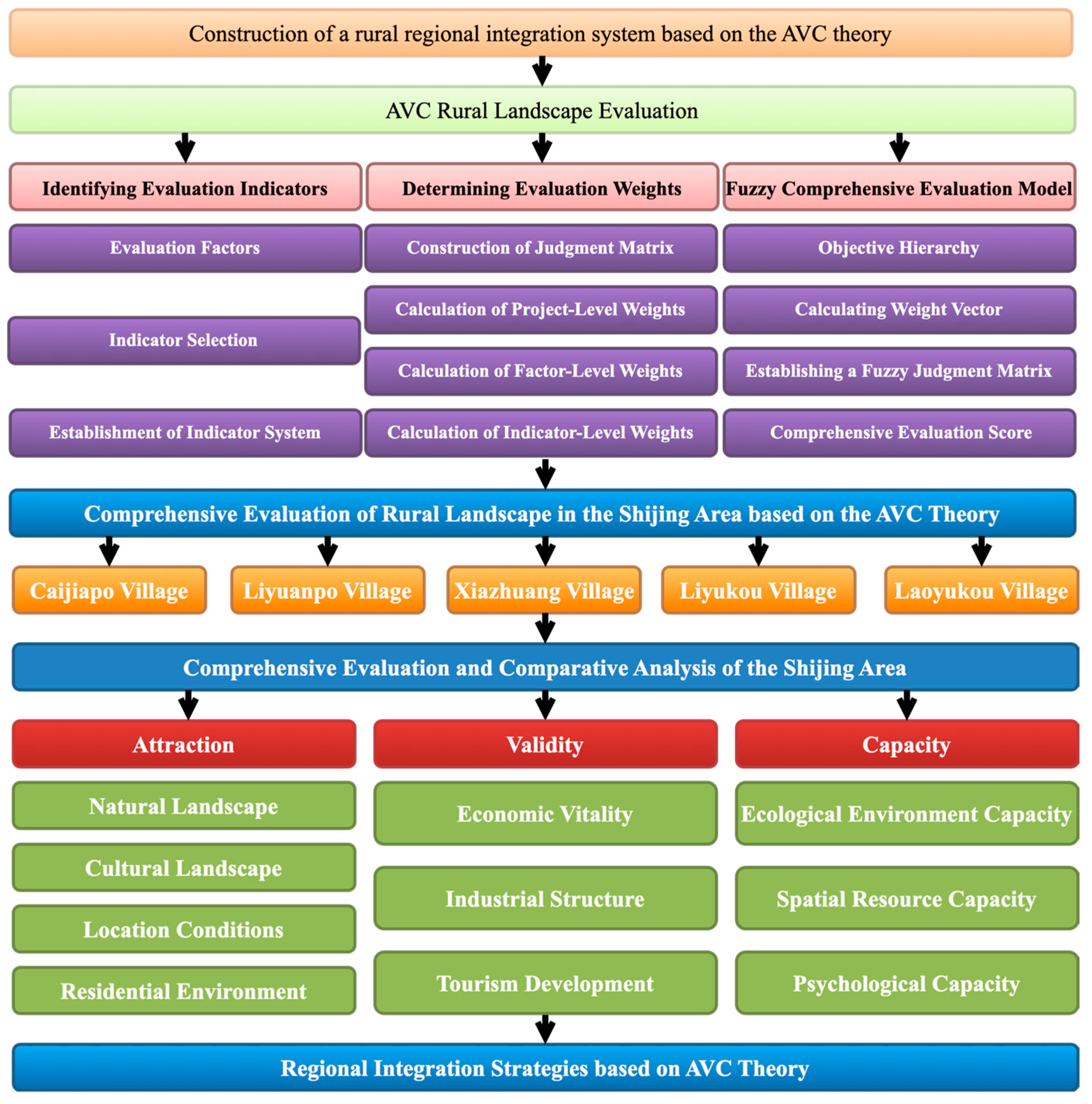
To apply the fuzzy comprehensive evaluation method, the indicators determined by the AHP were considered the target hierarchy. AHP is a multicriteria decision analysis method that helps decision makers make accurate and consistent decisions by decomposing complex problems into hierarchical structures and conducting comparisons and weight assignments. It is applicable to various domains and provides a structured approach to assess and compare the relative importance of multiple factors and criteria. Subsequently, a set of evaluation factors, denoted as Z, is constructed to describe the indicators. For subjective indicators, survey questionnaire data were used, whereas for objective indicators, judgment matrices were constructed based on the corresponding evaluation criteria [38]. Next, the weight vector was calculated using the AHP method, and an appropriate synthesis operator was selected to compute the comprehensive index [39,40].
Next, a fuzzy judgment matrix was established. The fuzzy judgment matrix R is composed of the membership degrees of the indicator set U with respect to the evaluation-level set V, representing the fuzzy relationship between U and V. Based on the weights of the indicators and the fuzzy judgment matrix, each level of the evaluation-level set V is assigned a weighted score (Figure 2).
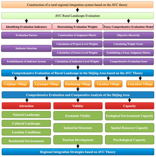
Figure 2.
Research Framework.
Finally, a fuzzy algorithm was used to conduct a comprehensive evaluation of the indicator system and obtain a comprehensive score. Referring to the membership degree function, the rural landscapes of various villages in the Shijing area of Xi’an City were evaluated and rated.
2.3. Model Construction
2.3.1. AVC Rural Landscape Comprehensive Evaluation Index Determination
- Preliminary Construction of Evaluation Factors
Based on the rural tourism landscape theory and AVC three-force theory mentioned earlier, the division of rural landscape evaluation indicators based on the attractiveness, vitality, and carrying capacity of the AVC theory was organized in recent years. According to the theoretical foundation of the rural tourism landscape design mentioned earlier and the AVC three-force theory, a preliminary AVC rural landscape comprehensive evaluation system was established, as shown in the Supplementary File.
- 2.
- Index Selection
Based on the selected set of indicators, this study evaluates their importance. A questionnaire survey was conducted with experts and scholars in landscape planning and rural tourism development using a five-point Likert scale (see Supplementary File). The questionnaires were collected, and the data were input into SPSS Statistics software (version 26.0) for factor analysis. Because this study involved 34 factors and required a sample size of no less than 170, 200 importance assessment questionnaires were distributed, with 100 distributed offline and 100 distributed online. Ultimately, 193 questionnaires were collected, with a response rate of 96.5%.
- Reliability Test
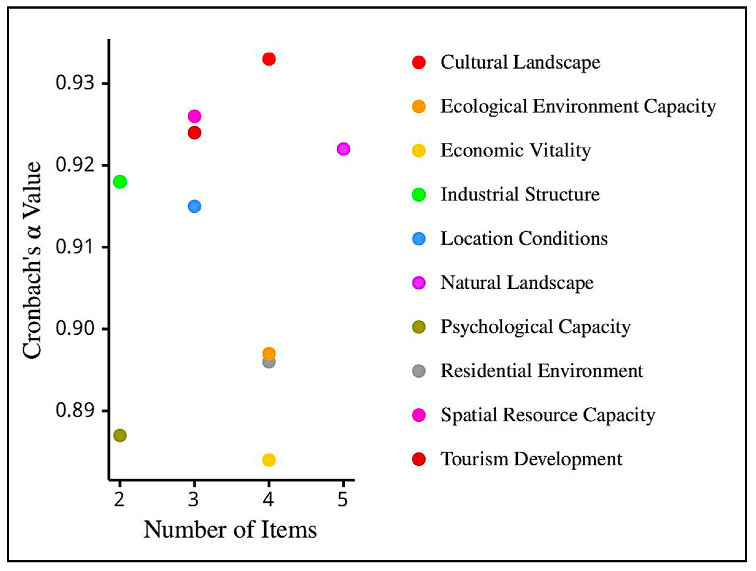
The collected survey data were subjected to reliability analysis using the SPSS software, and the results are shown in Figure 3. The results indicated that the overall Cronbach’s α value for the survey questionnaire was 0.913, which is >0.9, and the α values for the individual indicators were all >0.8. This indicates that the scale used in this study is highly reliable and provides a solid foundation for further research.
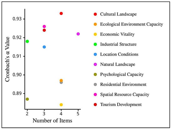
Figure 3.
Reliability Analysis of Sample Factor Layer and Total Sample Size.
- Factor Analysis
The data were entered into SPSS Statistics software (version 26.0) for the Kaiser–Meyer–Olkin (KMO) test, and the results showed a KMO value of 0.850, which falls within the significant range of 0.8–0.9. This confirmed that the collected data were suitable for factor analysis. Bartlett’s test of sphericity yielded a significance level of 0.000 < 0.05, indicating that the survey questionnaire had good validity. Table 1 presents the results of the study.

Table 1.
Sample KMO and Bartlett’s Test Results.
This study utilized correlation and principal component analysis (PCA) for index selection. All data were imported into SPSS Statistics software (version 26.0), and indicators with correlation coefficients >0.7 were removed. The remaining indicators were subjected to PCA; the results are provided in the Supplementary File. Based on communalities and factor loadings, indicators with communalities <0.7 were eliminated.
- 3.
- Establishment of Indicator System
The indicators were reorganized, resulting in the formation of an evaluation indicator system. In this system, the principal component factors were selected based on eigenvalues >1. Typically, a cumulative contribution rate of 70% or higher is desirable, indicating a reasonable indicator system. In this study, a total of 10 principal component factors were extracted as primary indicators, with a cumulative contribution rate of 77.2%. This indicates that the system can effectively summarize the information contained within it. The final rural landscape evaluation indicators generated using PCA are presented in Table 2.

Table 2.
Comprehensive Evaluation Indicators of AVC Rural Landscape.
2.3.2. Establishment of Weights for AVC Rural Landscape Indicators
- 1.
- Constructing Judgment Matrix
Thirty questionnaires were distributed to scholars in relevant fields. Using a pairwise comparison method, each the two indicators were compared to assess their importance. The correlation coefficients between the current and previous indicators were also compared to establish a judgment matrix for that indicator. When comparing a certain factor at the previous level with another factor at the current level, the relative weight, Tij, was used for quantification. For a comprehensive evaluation of AVC rural landscapes, which is the overall objective (A), the relative importance relationships between the sublevels (B) were constructed using the expert questionnaire survey results to form the judgment matrix. The results are summarized in Table 3.

Table 3.
Relative Importance Judgment Matrix of Rural Landscape Comprehensive Evaluation (A).
- 2.
- Calculation of Sub-level Weights
- Calculate the product of each row in the judgment matrix:
- Calculate the nth root of :
- Normalize the vector to obtain the weight vector:
Based on this, the weight values for the sub-levels of the AVC rural landscape evaluation system were obtained: the weight values for attractiveness, vitality, and resilience were 0.539, 0.297, and 0.164, respectively.
- Consistency Check
Owing to the complexity of objective phenomena and the subjectivity of decision makers’ perceptions, it is essential to conduct a consistency check on the judgment matrix following the AHP methodology.
First, the maximum eigenvalue of the judgment matrix is calculated:
Next, the consistency index is calculated:
when the consistency of the judgment matrix is high, the CI is low. Comparing the CI with the average random index (RI) value, the consistency ratio (CR) is obtained. If CR = CI/RI < 0.1, the matrix has a high level of consistency. If the result is opposite, it indicates insufficient consistency, and the calculation must be repeated (Table 4).

Table 4.
Average Random Index (RI) Values.
Through calculations, it was determined that the maximum eigenvalue λmax = 3.009, CI = 0.005, and the matrix order was three. By referring to the Table 4, the RI is found to be 0.52. The calculated CR = 0.009 < 0.1. Therefore, the judgment matrix satisfies the consistency check.
- 3.
- Calculation of Weights for the Factor and Indicator Levels
The judgment matrix, weights, and results of the consistency check for the factor and indicator levels calculated following the aforementioned method, can be found in the Supplementary File.
3. Results
3.1. Differential Analysis
3.1.1. Analysis of the Differences in Weighted Values of AVC Forces
Based on the previous section, the weighted values of the three AVC forces for rural landscapes were as follows: attractiveness (A), with a weight of 0.539, accounts for 54%; vitality (V), with a weight of 0.297, accounts for 30%; and carrying capacity (C), with a weight of 0.164, accounts for 16% of the total AVC. Therefore, the importance ranking of AVC forces for rural landscapes is as follows: A > V > C.
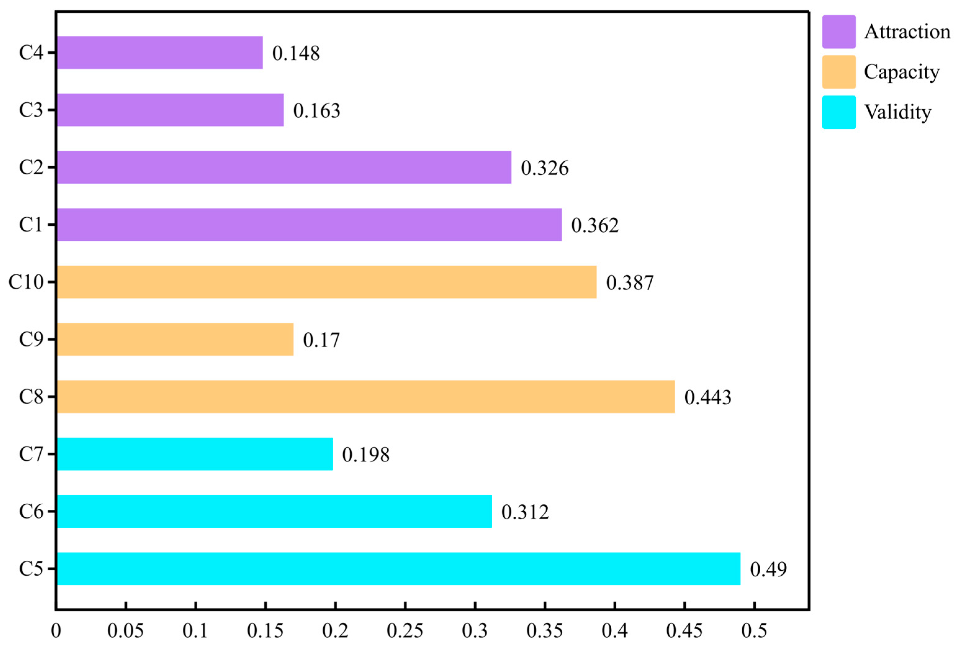
Based on the aforementioned weighted values of the factors, the distribution of the weight values is divided into five intervals as follows: general: 0–0.04, important: 0.04–0.08, relatively important: 0.08–0.12, very important: 0.12–0.16, and absolutely important: 0.16–0.20. As can be observed from Figure 4, natural and cultural landscapes are in the category of absolutely important, economic vitality is in the category of very important, industrial structure, location conditions, and settlement environment are in the category of relatively important, ecological environmental carrying capacity, psychological carrying capacity, and tourism development are in the category of important, and resource spatial carrying capacity is in the category of general (Figure 4).
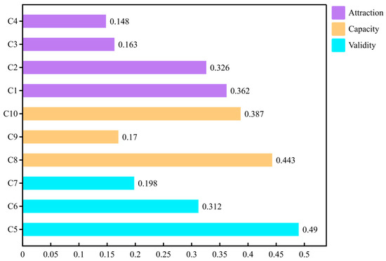
Figure 4.
Distribution of weights for the factor layer in AVC rural landscape evaluation. (C1 to C10 represent Natural Landscape, Cultural Landscape, Location Conditions, Residential Environment, Economic Vitality, Industrial Structure, Tourism Development, Ecological Environment Capacity, Spatial Resource Capacity, and Psychological Carrying Capacity, respectively).
3.1.2. Analysis of Weighted Differences in Attractiveness Indicators
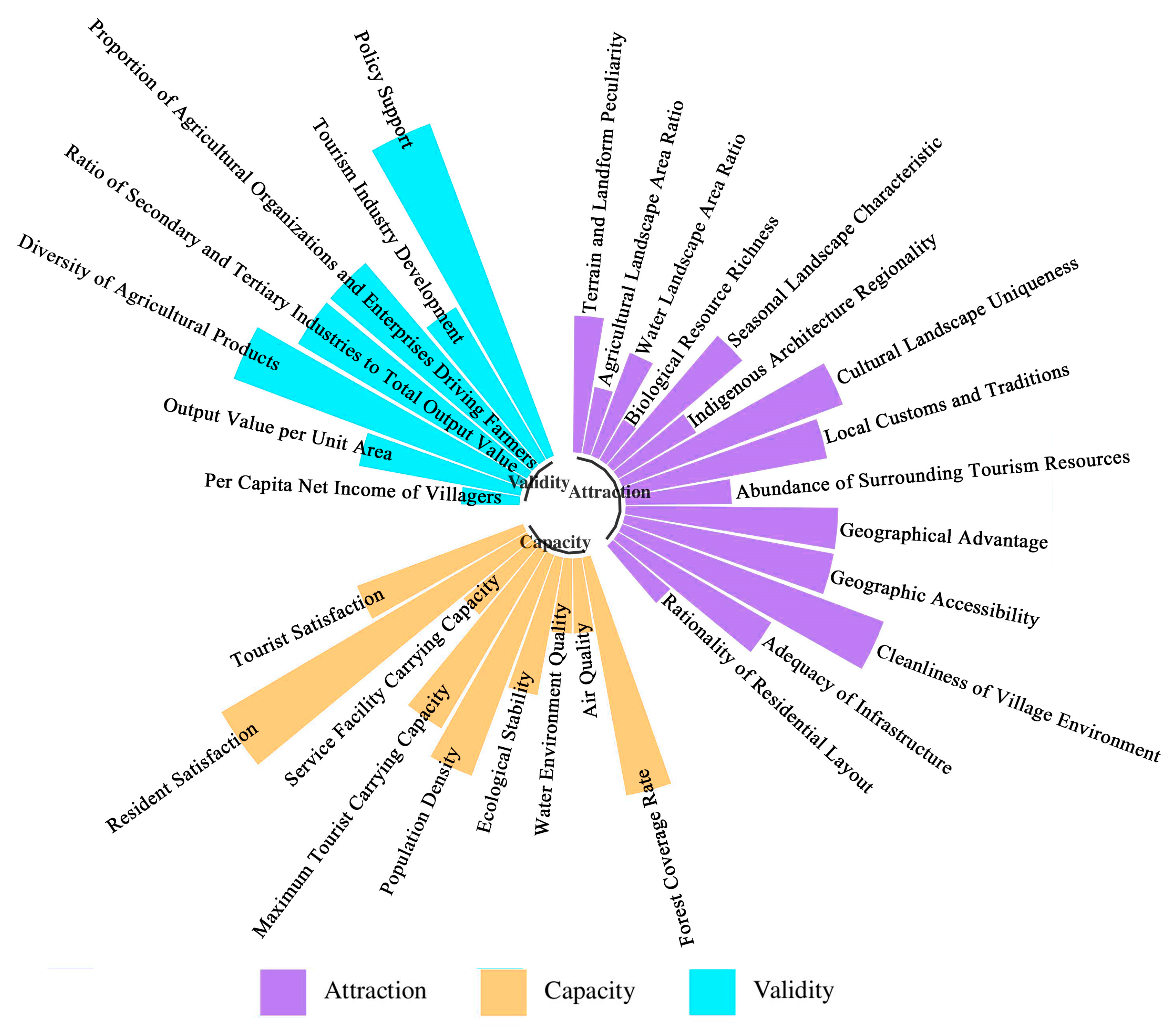
Figure 5 shows that natural and cultural landscapes have the highest proportions, while the settlement environment and location conditions have relatively lower proportions. The weights of natural landscapes, cultural landscapes, location conditions, and settlement environments were 0.362, 0.326, 0.163, and 0.148, respectively.
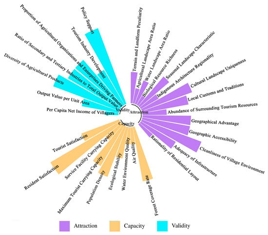
Figure 5.
Distribution of weights for the indicator layer.
The distribution of weighted values at the attractiveness indicator level was divided into five intervals as follows: general: 0–0.03, important: 0.03–0.06, relatively important: 0.06–0.09, very important: 0.09–0.12, and absolutely important: 0.12–0.15. The uniqueness of cultural landscapes, distinctiveness of local customs and traditions, seasonal landscape characteristics, and uniqueness of landforms all had relatively high importance levels above 0.09. In the planning and design processes, these aspects should be fully explored and utilized.
3.1.3. Analysis of Weighted Differences in Vitality Indicators
Economic vitality and industrial structure have the highest proportions in this group, whereas tourism development has a relatively lower proportion. The weight rankings of economic vitality, industrial structure, and tourism development were 0.362, 0.326, and 0.163, respectively.
The distribution of weighted values at the vitality indicator level was divided into five intervals as follows: general: 0–0.06, important: 0.06–0.12, relatively important: 0.12–0.18, very important: 0.18–0.24, and absolutely important: 0.24–0.30. Figure 5 shows that the importance level of agricultural product diversity is the highest.
3.1.4. Analysis of Weighted Differences in Carrying Capacity Indicators
Ecological and psychological carrying capacities had relatively higher proportions here, whereas resource spatial carrying capacities had a relatively lower proportion. The weight rankings of ecological carrying capacity, psychological carrying capacity, and spatial resource carrying capacity were 0.443, 0.387, and 0.170, respectively.
Based on the distribution of weighted values at the carrying capacity indicator level, it was divided into five intervals as follows: general: 0–0.06, important: 0.06–0.12, relatively important: 0.12–0.18, very important: 0.18–0.24, and absolutely important: 0.24–0.30. Figure 5 shows that resident satisfaction, forest coverage rate, and tourist satisfaction had high importance levels at >0.12.
3.2. Rural Landscape Evaluation Analysis
3.2.1. Evaluation Data Processing
- 1.
- Reliability and Validity Test
The survey was conducted offline using a questionnaire. A total of 400 questionnaires were distributed, 80 to each of the five villages. After excluding 11 incomplete or maliciously completed questionnaires, 389 valid questionnaires were collected, resulting in a response rate of 97.25%. Valid questionnaires were distributed as follows: 79 from Caijiapo Village, 77 from Liyuanpo Village, 79 from Xiazhuang Village, 78 from Liyukou Village, and 76 from Laoyukou Village. The collected survey questionnaire data were entered into the SPSS software for reliability and validity testing, and the following results were obtained.
Table 5 shows that the Cronbach’s alpha coefficients for all five sets of questionnaires were >0.8, indicating a high level of reliability of the survey questionnaire. The KMO values are all within the range of 0.8–0.7, indicating a high level of validity and enabling further analysis of the indicator factors. Through comprehensive testing, the reliability and validity of the questionnaire were determined to be high.

Table 5.
Research Data Validity Test.
- 2.
- AVC Rural Landscape Comprehensive Evaluation
By organizing and summarizing the rural landscape information data and calculating the weight values of the evaluation results for all factors, a fuzzy comprehensive judgment matrix was established. Based on the questionnaire data, the fuzzy comprehensive evaluation matrix RC of factor layer C was established.
3.2.2. Comprehensive Evaluation Results
- 1.
- Comprehensive Analysis
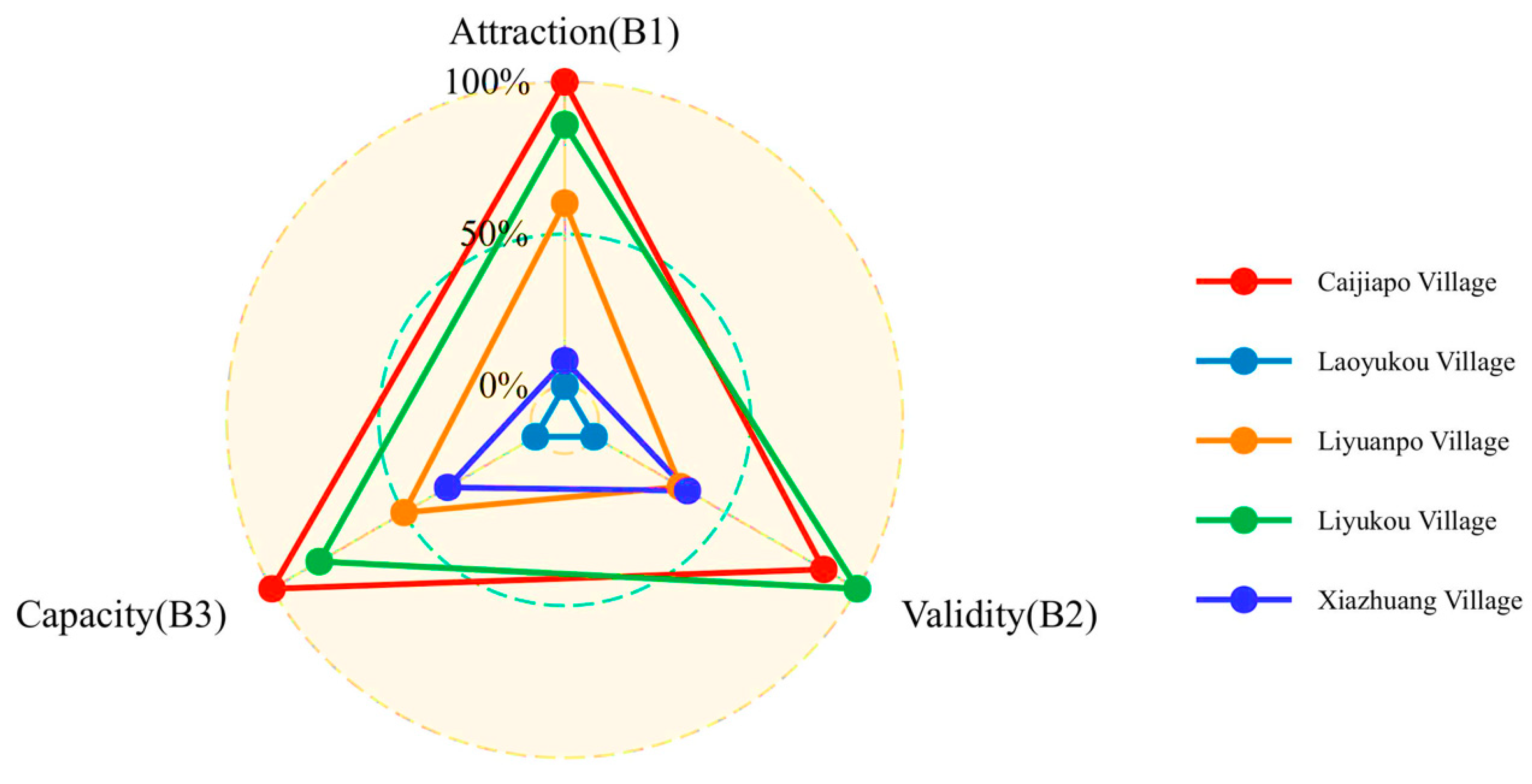
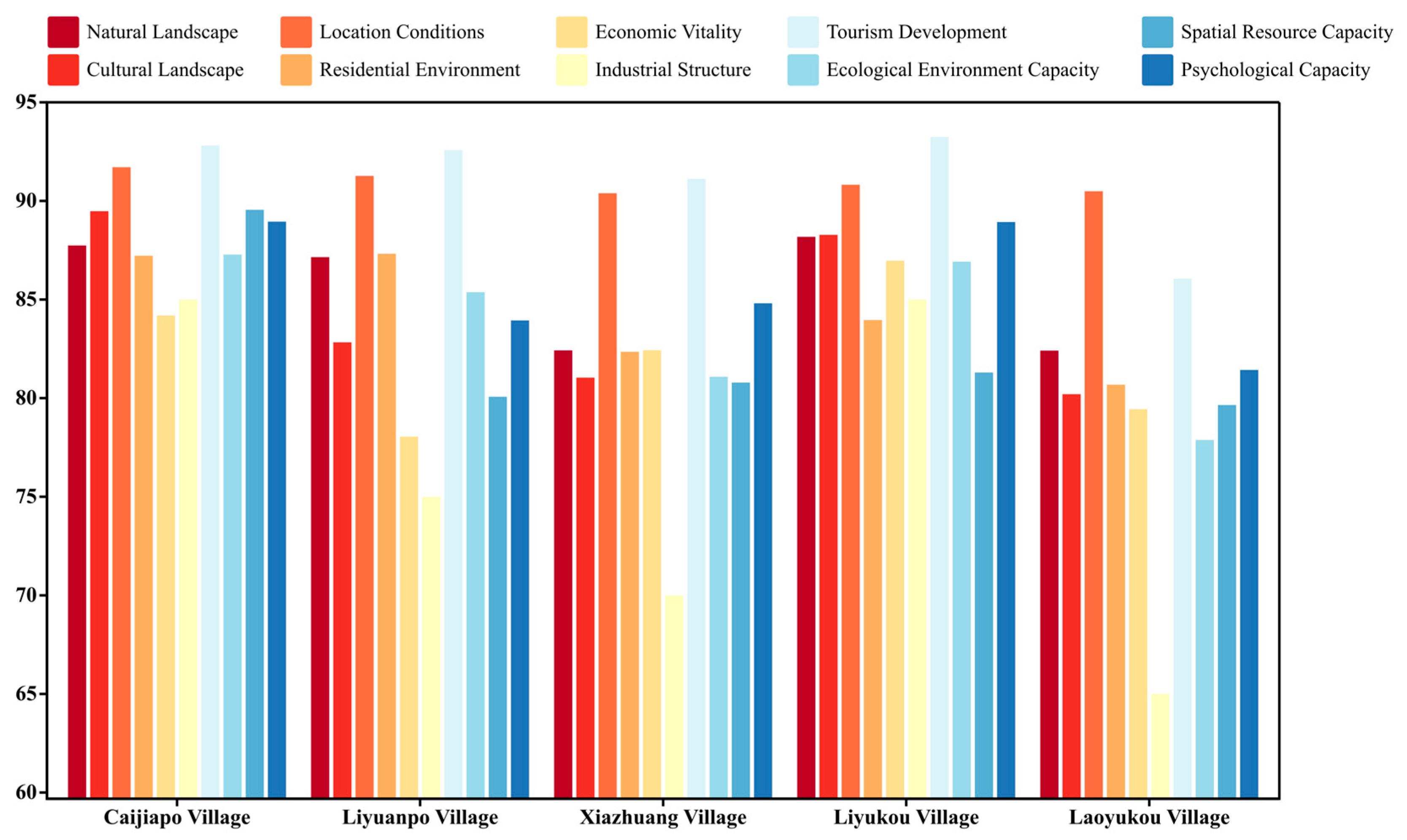
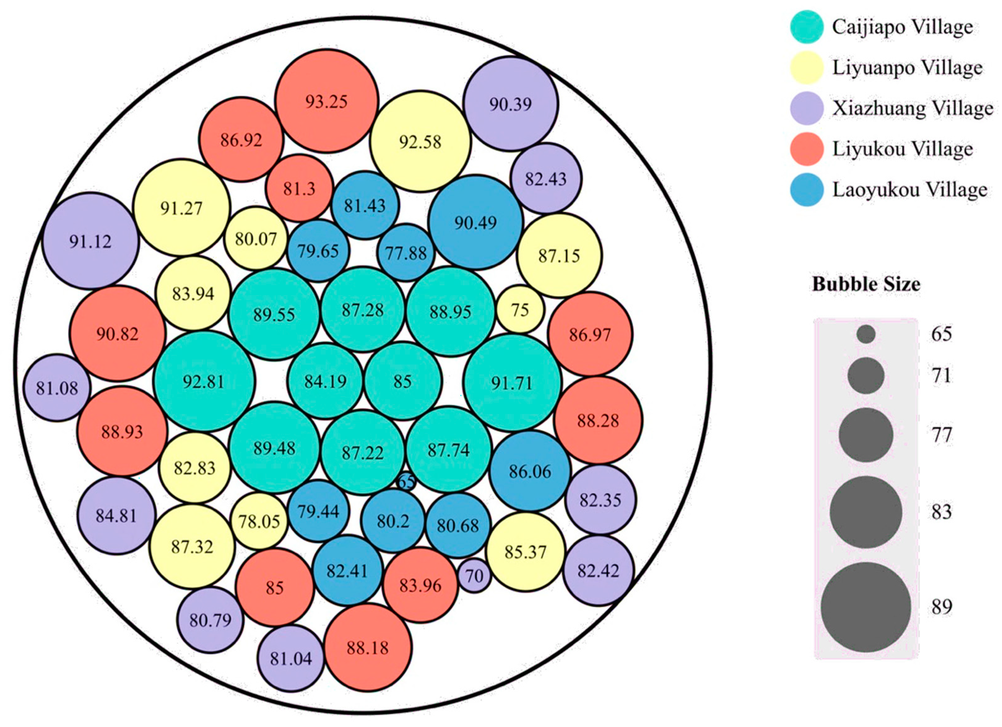
According to the comprehensive landscape evaluation of Caijiapo, Liyuanpo, Xiazhuang, Liyukou, and Laoyukou Villages, Caijiapo Village had a comprehensive evaluation score of 87.93, which was classified as F2 (good). Liyuanpo Village has a comprehensive evaluation score of 84.06, classified as F3 (fair). Xiazhuang Village had a comprehensive evaluation score of 82.19, also classified as F3 (fair). Liyukou Village had a comprehensive evaluation score of 87.64, classified as F2 (good). Laoyukou Village had a comprehensive evaluation score of 80.25, classified as F3 (fair). The comprehensive evaluation results show that Caijiapo and Liyukou Villages are generally in good condition, while Liyuanpo, Xiazhuang, and Laoyukou Villages are in fair condition. There are differences in the current development status of each village in various aspects, and each village has the potential for rural tourism development; however, the overall carrying capacity and vitality are relatively weak. In future integrated planning and development, efforts should be made to enhance economic vitality, resource space, and ecological carrying capacity; fully leverage landscape resources; and achieve sustainable development (Figure 6 and Figure 7).
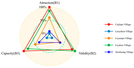
Figure 6.
Evaluation results of indicators at the project level.
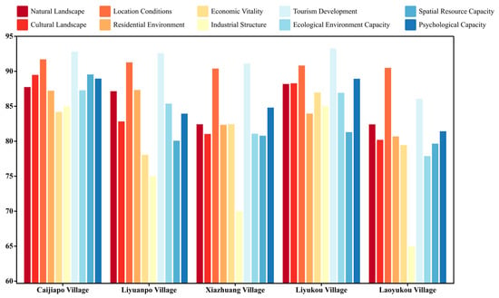
Figure 7.
Evaluation results of indicators at the factor level.
- 2.
- Analysis of Three Forces
- Caijiapo Village
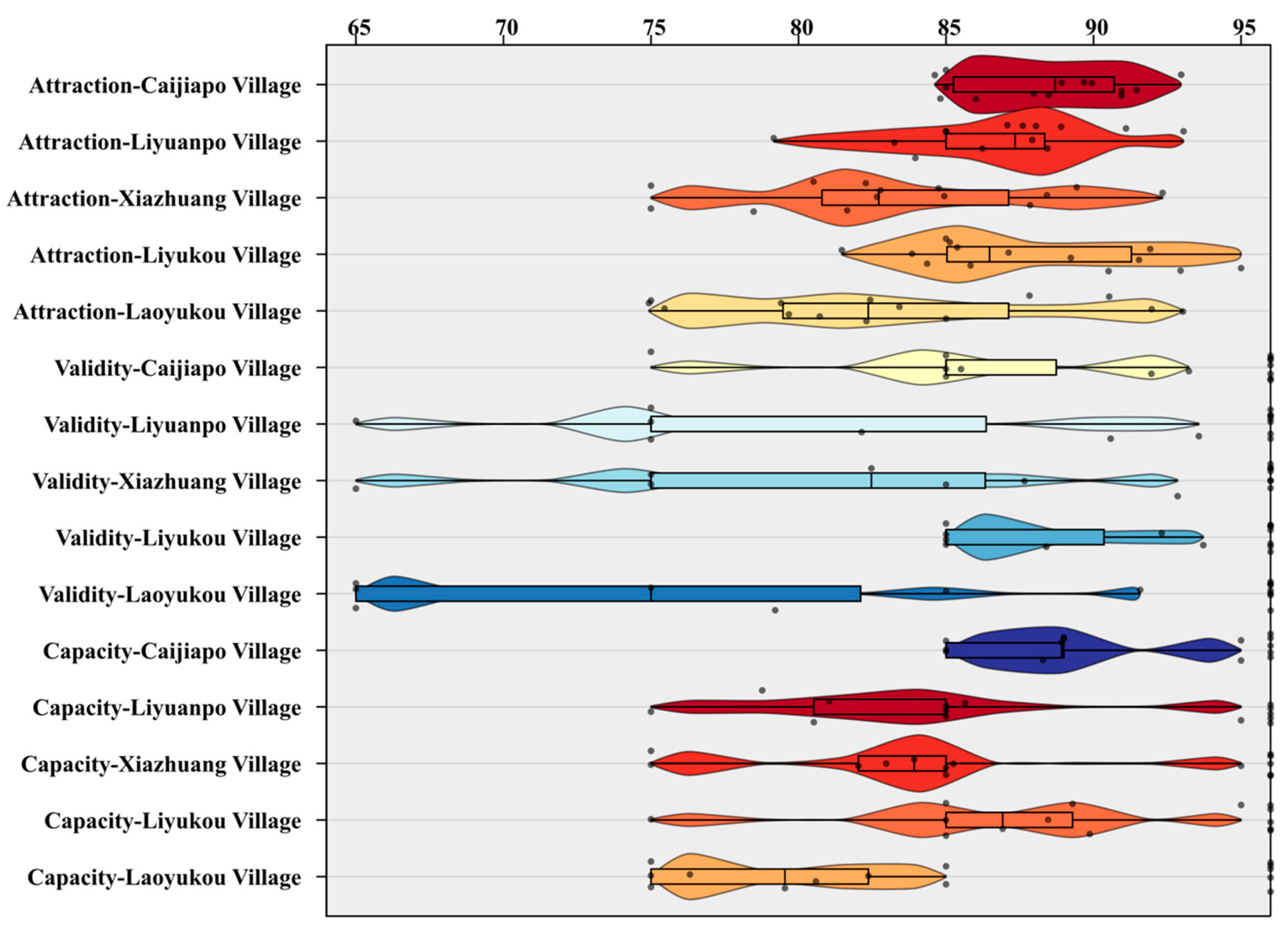
Attractiveness Evaluation: There were ten indicators with scores in the F2 (good) level and four indicators with scores in the F3 (average) level. Among all indicators, the scores for geographic accessibility, geographical advantage, unique landforms, and cultural landscape uniqueness were relatively high at >90 points.
Vitality Evaluation: There were three indicators with scores at the F2 (good) level, three indicators with scores at the F3 (average) level, and one indicator with a score at the F4 (poor) level. Among all indicators, the scores for policy support and tourism industry development were relatively high at >90 points.
Carrying Capacity Evaluation: There were six indicators with scores at the F2 (good) level and three indicators with scores at the F3 (average) level. Among all indicators, air quality and maximum tourist carrying capacity had the highest scores, both at 95 points.
- Liyuanpo Village
Attractiveness Evaluation: There were nine indicators with scores at the F2 (good) level and five indicators with scores at the F3 (average) level. Among all the indicators, the scores for geographic accessibility, geographical advantage, unique landforms, rich biological resources, and abundant surrounding tourist resources were relatively high (above 88 points).
Vitality Evaluation: Policy support and development of the tourism industry were at the F2 (good) level. However, agricultural diversity, per unit area output value, the proportion of secondary and tertiary industries in the total output value, and the proportion of agricultural organizations and enterprises driven by farmers were at the F4 (poor) level. The score for villagers per capita net income was 65, the lowest among the vitality indicators, indicating a very poor level (F5).
Carrying Capacity Evaluation: There were two indicators with scores at the F2 (good) level, six indicators with scores at the F3 (average) level, and one indicator with a score at the F4 (poor) level. Among all the indicators, air quality and resident satisfaction had the highest scores (95 and 85.65 points, respectively), whereas maximum tourist carrying capacity had the lowest score (75 points).
- Xiazhuang Village
Attractiveness Evaluation: There were four indicators with scores at the F2 (good) level, eight indicators with scores at the F3 (average) level, and two indicators with scores at the F4 (poor) level. Among all indicators, the scores for geographic accessibility, geographical advantage, abundance of surrounding tourist resources, and seasonal landscape characteristics were relatively high at >85 points.
Vitality Evaluation: Policy support and development of the tourism industry were at the F2 (good) level. The per-unit area output value and agricultural diversity were at the F3 (average) level. However, the per-capita income of villagers and the proportion of secondary and tertiary industries in the total output value were at the F4 (poor) level. The score for the proportion of agricultural organizations and enterprises driven by farmers was 65, the lowest among the vitality indicators, indicating a very poor level (F5).
Carrying Capacity Evaluation: There were two indicators with scores at the F2 (good) level, five indicators with scores at the F3 (average) level, and two indicators with scores at the F4 (poor) level. Among all the indicators, air quality and resident satisfaction had the highest scores of 95 and 85.25 points, respectively, whereas maximum tourist carrying capacity and forest coverage had the lowest scores of 75 points.
- Liyukou Village
Attractiveness Evaluation: There were ten indicators with scores in the F2 (good) level and four indicators with scores in the F3 (average) level. Among all indicators, the scores for the ratio of agricultural landscape area, geographic accessibility, unique cultural landscape, geographical advantage, and unique landform were relatively high at >90 points.
Vitality Evaluation: It consisted of three factors and seven indicators. Policy support, tourism development, and agricultural diversity were at the F2 (good) level, ranging from 85 to 95 points. The per unit area output value, agricultural diversity, per capita income of villagers, and proportion of secondary and tertiary industries in the total output value were at the F3 (average) level, all at 85 points.
Carrying Capacity Evaluation: It consisted of three factors and nine indicators. Five indicators scored at the F2 (good) level, three indicators at the F3 (average) level, and one indicator at the F4 (poor) level. Among all indicators, air quality, tourist satisfaction, service facility capacity, resident satisfaction, and ecological stability had relatively high scores, ranging from 85 to 95 points.
- Laoyukou Village
Attractiveness Evaluation: There were four indicators with scores at the F2 (good) level, eight indicators with scores at the F3 (average) level, and two indicators with scores at the F4 (poor) level. Among all indicators, the scores for geographic accessibility, geographical advantage, seasonal landscape characteristics, and rich biological resources were relatively good, all above 85 points.
Vitality Evaluation: Policy support was at the F2 (good) level, with a score of 91.58 points. The per-unit area output value and agricultural diversity were at the F3 (average) level, whereas tourism industry development was at the F4 (poor) level. The proportion of agricultural organizations and enterprises driving farmers, the per capita income of villagers, and the proportion of secondary and tertiary industries in the total output value were very poor (F5).
Carrying Capacity Evaluation: There were six indicators with scores at the F3 (average) level and three indicators with scores at the F4 (poor) level. Among all indicators, air quality and population density had relatively high scores, both at 85 points. However, forest coverage, water quality, and maximum tourist carrying capacity had relatively low scores (75) (Figure 8).
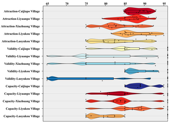
Figure 8.
The distribution of three-force analysis results of five village groups. (Different colors represent the three-force analysis of different villages, the curve represents the distribution of scoring values, and the black dots represent specific numerical values).
3.3. Analysis of Comprehensive Evaluation of Rural Landscape in Shijing Area
3.3.1. Comparative Analysis of Comprehensive Rural Landscape in Shijing Area
By analyzing the comprehensive scores of rural landscapes in the Shijing area, the ranking of the five villages in the area was as follows: Caijiapo Village > Liyukou Village > Liyuanpo Village > Xiazhuang Village > Laoyukou Village. It can be seen that among the villages in the study area, Caijiapo and Liyukou Villages have the strongest overall strength, with Caijiapo Village being the most prominent. Liyuanpo and Xiazhuang had moderate overall strength, whereas Laoyukou had the weakest overall strength. Therefore, in planning the area, Caijiapo Village can be considered as the core village, with Liyukou Village as the secondary core village, to drive the overall development of the entire area. All five villages have abundant natural landscapes and favorable location conditions, possessing the potential for rural tourism development and strong attractiveness.
3.3.2. Comprehensive Analysis of Three Forces in Rural Landscape of Shijing Area
- 1.
- Attraction
According to the comprehensive score of attractiveness indicators in the Shijing area, in terms of natural landscape indicators, Liyukou, Liyupo, and Caijiapo Villages had relatively high scores, whereas Laoyukou and Xiazhuang Villages had lower scores. In terms of cultural landscape indicators, Liyukou and Caijiapo had the highest scores, Xiazhuang and Liyuanpo were in the middle, and Laoyukou had the lowest score. Regarding location condition indicators, the score differences were not significant; overall, they were relatively high. In terms of the settlement environment, Liyuanpo and Caijiapo had the highest scores, followed by Liyukou and Xiazhuang, while Laoyukou had the lowest score (Figure 9).
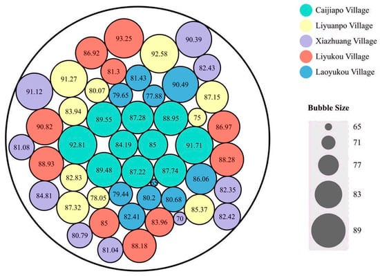
Figure 9.
Comparative Analysis of Three Forces in Shijing Area.
- 2.
- Vitality
According to the comprehensive score of vitality indicators in the Shijing area, it can be observed that in terms of economic vitality indicators, Liyukou and Caijiapo Villages have the highest scores, Xiazhuang and Laoyukou Villages have moderate scores, and Liyuanpo Village has the lowest score. In terms of industrial structure indicators, Liyukou and Caijiapo Villages had the highest scores, whereas Laoyukou Village had the lowest, showing significant differences among the five villages. In terms of tourism development indicators, all five villages had relatively high scores, with small differences between them (Figure 9).
- 3.
- Capacity
From the comprehensive score of carrying capacity, it can be seen that, in terms of ecological environment carrying capacity indicators, Liyukou, Liyuanpo, and Caijiapo Villages had the highest scores, while Laoyukou Village had the lowest. In terms of resource spatial carrying capacity indicators, Caijiapo had the highest score, while the other villages had lower scores, with significant differences compared to Caijiapo. In terms of psychological carrying capacity indicators, Liyukou and Caijiapo had higher scores, Xiazhuang and Liyuanpo had moderate scores, and Laoyukou had the lowest score (Figure 9).
4. Discussion
AVC theory has not been fully applied or explored in regional integration planning. Therefore, applying this theory to the study of regional integration can provide new perspectives and ideas for theoretical research in this field, expanding the depth and breadth of research. This study incorporated the evaluation model of AVC theory into regional integration planning, fully explored the potential of villages within the region, comprehensively assessed the feasibility and necessity of regional landscape integration, provided a scientific basis for strategy formulation, and achieved better protection and sustainable utilization of rural landscapes. This study provides new insights into rural tourism development. Currently, research on rural tourism landscapes mostly focuses on individual village planning and lacks synergy between local and regional development [41,42]. Integration planning is more beneficial for exploring rural characteristics, coordinating and organizing at the macro level, maximizing overall benefits through complementarity and coordinated development, enhancing regional influence, and driving overall economic development [43].
The results of this study are consistent with those of previous studies. Some scholars have used the AVC theory framework to assess the sustainable development of rural tourism landscapes, and their research has emphasized the importance of landscape quality and economic vitality. This is consistent with the conclusions of this study, further supporting the application of AVC theory to rural tourism research [31,44,45]. Other scholars have explored landscape evaluation methods in rural tourism development and proposed a comprehensive evaluation model that aligns with the landscape evaluation system in this study, supporting the use of factor analysis and weight calculation methods [26,46].
Furthermore, several studies have supported the results of the present study. Some scholars have extensively discussed the interaction and impact of tourism and water resources in their work, which are important for the sustainable development of rural tourism landscapes addressed in this study [47,48,49,50]. Other scholars have conducted in-depth research on the relationship between the environment and tourism, providing theoretical support for the ecological carrying capacity emphasized in this article [51,52,53]. Additionally, some studies present integrated and sustainable tourism planning approaches, providing insights into the integrated planning and development of rural tourism landscapes.
However, other studies have also yielded results different from the findings of this study. Some scholars have found that the economic vitality of rural tourism landscapes has a relatively small impact on sustainable development, while ecological carrying capacity and sociocultural factors have greater importance [54,55,56,57,58]. This differs from the conclusions of this study, which emphasize the varying roles of multiple factors in the sustainable development of rural tourism [45]. Other scholars have focused on the issue of social equity in the evaluation of rural tourism landscapes, they have found that social equity and spatial data for natural resources has a significant influence on the sustainable development of rural tourism [59]. In contrast to the findings of this study, their research considered social equity an important dimension, highlighting its importance in the sustainable development of rural tourism [31,60]. In summary, based on the AVC theory, this study constructed an evaluation system for rural tourism landscapes through factor analysis and weight calculation and assessed the villages in the Shijing area. This aligns with the results of related studies, supporting the conclusions of the present study. However, this study also differs from other studies, further highlighting its contribution and uniqueness to the field of rural tourism research.
Owing to disciplinary limitations, this study primarily relies on theories and methods from the field of landscape architecture. Although relevant theories from other disciplines, such as tourism, ecology, and economics, have been referenced and studied, some biases and shortcomings may still exist. Therefore, in future research, more attention should be paid to interdisciplinary inte-gration to understand and apply relevant theories and methods comprehensively and deeply. Additional research is necessary to delve into the interactions and influence mechanisms among different elements in rural areas, aiming to accomplish the objective of achieving coordinated development across society, economy, and ecology. In addition, there is a need for strengthened research on institutional safeguards and policy guidance to provide robust support for sustainable development in rural areas.
5. Conclusions
This study is based on the AVC theory to explore the sustainable development path of rural tourism, the economy, and ecology. Through theoretical research and exploration of the correlations between key factors, an AVC rural regional integration framework was established. Based on the study, the rural landscape evaluation system based on AVC theory was established through correlation analysis and PCA using factor analysis to select indicators. The weights of each indicator factor were determined through expert scoring, construction of judgment matrices, and consistency testing.
The scoring data corresponding to the subjective and objective indicators in the integrated survey questionnaire were organized and calculated using SPSS and Excel, resulting in scores and rankings for each village. The Caijiapo, Liyuanpo, Xiazhuang, Liyukou, and Laoyukou Villages had comprehensive scores of 88.79 (good level), 84.06 (average level), 82.19 (average level), 87.64 (good level), and 80.25 (average level), respectively. Caijiapo and Liyukou had the strongest overall strength, Liyuanpo and Xiazhuang had moderate overall strength, and Laoyukou had the weakest overall strength. The overall evaluation results show that all five villages have abundant natural landscapes and favorable location conditions, possessing the potential for rural tourism development and strong attractiveness. However, the overall carrying capacity was moderate and the overall vitality was weak. In future programs involving integrated planning and development, it is necessary to fully leverage the advantages of regional landscape resources, enhance landscape quality and economic vitality, and increase the resource space-carrying capacity and ecological carrying capacity to achieve sustainable development in the area.
Owing to limitations of the discipline, this study predominantly draws on landscape architecture theories and methods, while referencing theories from disciplines such as tourism, ecology, and economics. Despite this, biases and shortcomings may persist. To address this, future research should prioritize interdisciplinary integration for a comprehensive application of these theories. Moreover, further investigations are warranted to explore the interactions among rural elements, fostering coordinated development of society, economy, and ecology. Additionally, robust research on institutional safeguards and policy guidance is crucial to support sustainable rural development.
Supplementary Materials
The following supporting information can be downloaded at: https://www.mdpi.com/article/10.3390/land12071473/s1.
Author Contributions
Conceptualization, L.L. and P.L.; methodology, R.W.; validation, R.W., Y.L. and Y.S.; formal analysis, R.W.; data curation, R.W.; writing—original draft preparation, B.H.; writing—review and editing, L.L., M.H. and S.H. All authors have read and agreed to the published version of the manuscript.
Funding
This research was funded by China Scholarship Council (Grant No.: Liujinmei [2022] No. 45; Liujinxuan [2022] No. 133; Liujinou [2023] No. 22), International Education Research Program of Chang’an University (300108221102), Project of Ningxia Natural Science Foundation (2022AAC03700; 2022BEG03059), 2022 Guangdong University Youth Innovation Talent Program (2022KQNCX143), the GDAS Special Project of Science and Technology Development (2021GDASYL-20210103046) and Asia–Pacific Network for Global Change Research (CRRP2020-03MY-He), the Guangdong Foundation for Program of Science and Technology Research (2021A1313030057), Yinshanbeilu Grassland Eco-hydrology National Observation and Research Station, China Institute of Water Resources and Hydropower Research, Beijing 100038, China, (Grant No. YSS2022004).
Data Availability Statement
Not applicable.
Acknowledgments
The authors gratefully thank the editors and anonymous reviewers for their valuable advice in improving this manuscript.
Conflicts of Interest
The authors declare no conflict of interest.
References
- Haibo, C.; Ayamba, E.C.; Udimal, T.B.; Agyemang, A.O.; Ruth, A. Tourism and sustainable development in China: A review. Environ. Sci. Pollut. Res. 2020, 27, 39077–39093. [Google Scholar] [CrossRef]
- Liu, Y.; Zang, Y.; Yang, Y. China’s rural revitalization and development: Theory, technology and management. J. Geogr. Sci. 2020, 30, 1923–1942. [Google Scholar] [CrossRef]
- Kapur, R. Significance of Rural Development. Acta Sci. Agric. 2019, 3, 167–173. [Google Scholar] [CrossRef]
- Scoones, I. Livelihoods perspectives and rural development. J. Peasant Stud. 2009, 36, 171–196. [Google Scholar] [CrossRef]
- Cook, P. Infrastructure, rural electrification and development. Energy Sustain. Dev. 2011, 15, 304–313. [Google Scholar] [CrossRef]
- Gansauer, G.; Haggerty, J. Beyond city limits: Infrastructural regionalism in rural Montana, USA. Territ. Politics Gov. 2021, 9, 1–19. [Google Scholar] [CrossRef]
- Gutierrez-Velez, V.H.; Gilbert, M.R.; Kinsey, D.; Behm, J.E. Beyond the ‘urban’ and the ‘rural’: Conceptualizing a new generation of infrastructure systems to enable rural–urban sustainability. Curr. Opin. Environ. Sustain. 2022, 56, 101177. [Google Scholar] [CrossRef]
- Agnoletti, M.; Emanueli, F.; Corrieri, F.; Venturi, M.; Santoro, A. Monitoring Traditional Rural Landscapes. The Case of Italy. Sustainability 2019, 11, 6107. [Google Scholar] [CrossRef]
- Wang, D.; Ji, X.; Jiang, D.; Liu, P. Importance assessment and conservation strategy for rural landscape patches in Huang-Huai plain based on network robustness analysis. Ecol. Inform. 2022, 69, 101630. [Google Scholar] [CrossRef]
- Palang, H.; Mander, Ü.; Luud, A. Landscape diversity changes in Estonia. Landsc. Urban Plan. 1998, 41, 163–169. [Google Scholar] [CrossRef]
- Wang, X.; Luo, P.; Zheng, Y.; Duan, W.; Wang, S.; Zhu, W.; Zhang, Y.; Nover, D. Drought Disasters in China from 1991 to 2018: Analysis of Spatiotemporal Trends and Characteristics. Remote Sens. 2023, 15, 1708. [Google Scholar] [CrossRef]
- Lipsky, Z. The changing face of the Czech rural landscape. Landsc. Urban Plan. 1995, 31, 39–45. [Google Scholar] [CrossRef]
- Lin, L.; Wei, X.; Luo, P.; Wang, S.; Kong, D.; Yang, J. Ecological Security Patterns at Different Spatial Scales on the Loess Plateau. Remote Sens. 2023, 15, 1011. [Google Scholar] [CrossRef]
- Antrop, M. Landscape change and the urbanization process in Europe. Landsc. Urban Plan. 2004, 67, 9–26. [Google Scholar] [CrossRef]
- Ruda, G. Rural buildings and environment. Landsc. Urban Plan. 1998, 41, 93–97. [Google Scholar] [CrossRef]
- Poudevigne, I.; van Rooij, S.; Morin, P.; Alard, D. Dynamics of rural landscapes and their main driving factors: A case study in the Seine Valley, Normandy, France. Landsc. Urban Plan. 1997, 38, 93–103. [Google Scholar] [CrossRef][Green Version]
- Guo, B.; Wu, H.; Pei, L.; Zhu, X.; Zhang, D.; Wang, Y.; Luo, P. Study on the spatiotemporal dynamic of ground-level ozone concentrations on multiple scales across China during the blue sky protection campaign. Environ. Int. 2022, 170, 107606. [Google Scholar] [CrossRef]
- Cook, E.A.; Van Lier, H.N. Landscape planning and ecological networks. In Landscape Planning and Ecological Networks; Developments in Landscape Management & Urban Planning, 6F; Elsevier: Amsterdam, The Netherlands, 1994. [Google Scholar]
- Yang, Q. Research on the Changes in Cultural Landscape of Tourist-Type Traditional Chinese Villages from the Perspective of Cultural Memory: Taking Anzhen Village in Chongqing as an Example. Land 2023, 12, 816. [Google Scholar] [CrossRef]
- Campos-Taberner, M.; García-Haro, F.J.; Martínez, B.; Izquierdo-Verdiguier, E.; Atzberger, C.; Camps-Valls, G.; Gilabert, M.A. Understanding deep learning in land use classification based on Sentinel-2 time series. Sci. Rep. 2020, 10, 17188. [Google Scholar] [CrossRef] [PubMed]
- Moharram, M.A.; Sundaram, D.M. Land use and land cover classification with hyperspectral data: A comprehensive review of methods, challenges and future directions. Neurocomputing 2023, 536, 90–113. [Google Scholar] [CrossRef]
- Zhang, R.; Zhang, X. Spatial Pattern Evolution and Driving Mechanism of Rural Settlements in Rapidly Urbanized Areas: A Case Study of Jiangning District in Nanjing City, China. Land 2023, 12, 749. [Google Scholar] [CrossRef]
- Wang, S.; Luo, P.; Xu, C.; Zhu, W.; Cao, Z.; Ly, S. Reconstruction of Historical Land Use and Urban Flood Simulation in Xi‘an, Shannxi, China. Remote Sens. 2022, 14, 6067. [Google Scholar] [CrossRef]
- Forman, R.T.T. Some general principles of landscape and regional ecology. Landsc. Ecol. 1995, 10, 133–142. [Google Scholar] [CrossRef]
- Arriaza, M.; Cañas-Ortega, J.F.; Cañas-Madueño, J.A.; Ruiz-Aviles, P. Assessing the visual quality of rural landscapes. Landsc. Urban Plan. 2004, 69, 115–125. [Google Scholar] [CrossRef]
- Xie, H.; Zhu, Z.; He, Y.; Zeng, X.; Wen, Y. Integrated framework of rural landscape research: Based on the global perspective. Landsc. Ecol. 2022, 37, 1161–1184. [Google Scholar] [CrossRef]
- Zasada, I.; Häfner, K.; Schaller, L.; van Zanten, B.T.; Lefebvre, M.; Malak-Rawlikowska, A.; Nikolov, D.; Rodríguez-Entrena, M.; Manrique, R.; Ungaro, F.; et al. A conceptual model to integrate the regional context in landscape policy, management and contribution to rural development: Literature review and European case study evidence. Geoforum 2017, 82, 1–12. [Google Scholar] [CrossRef]
- Meeus, S.J.; Gulinck, H. Semi-urban areas in landscape research: A review. Living Rev. Landsc. Res. 2008, 2, 1–45. [Google Scholar] [CrossRef]
- Zhang, H.; Duan, Y.; Han, Z. Research on Spatial Patterns and Sustainable Development of Rural Tourism Destinations in the Yellow River Basin of China. Land 2021, 10, 849. [Google Scholar] [CrossRef]
- Tian, Q.; Li, B.Y. Study on spatial characteristics and optimization of rural tourism spots in great wuyi tourism circle. J. Fujian Norm. Univ. 2020, 2, 91–99. [Google Scholar]
- Liu, Y.-L.; Chiang, J.-T.; Ko, P.-F. The benefits of tourism for rural community development. Humanit. Soc. Sci. Commun. 2023, 10, 137. [Google Scholar] [CrossRef]
- Rosalina, P.D.; Dupre, K.; Wang, Y. Rural tourism: A systematic literature review on definitions and challenges. J. Hosp. Tour. Manag. 2021, 47, 134–149. [Google Scholar] [CrossRef]
- Gao, J.; Wu, B. Revitalizing traditional villages through rural tourism: A case study of Yuanjia Village, Shaanxi Province, China. Tour. Manag. 2017, 63, 223–233. [Google Scholar] [CrossRef]
- Prabhakaran, S.; Nair, V.; Ramachandran, S. Community Participation in Rural Tourism: Towards a Conceptual Framework. Procedia Soc. Behav. Sci. 2014, 144, 290–295. [Google Scholar] [CrossRef]
- Giliberto, F.; Labadi, S. Harnessing cultural heritage for sustainable development: An analysis of three internationally funded projects in MENA Countries. Int. J. Herit. Stud. 2022, 28, 133–146. [Google Scholar] [CrossRef]
- Sardaro, R.; La Sala, P.; De Pascale, G.; Faccilongo, N. The conservation of cultural heritage in rural areas: Stakeholder preferences regarding historical rural buildings in Apulia, southern Italy. Land Use Policy 2021, 109, 105662. [Google Scholar] [CrossRef]
- Madanaguli, A.; Dhir, A.; Joseph, R.P.; Albishri, N.A.; Srivastava, S. Environmental sustainability practices and strategies in the rural tourism and hospitality sector: A systematic literature review and suggestions for future research. Scand. J. Hosp. Tour. 2023, 23, 1–28. [Google Scholar] [CrossRef]
- Qin, J.; Duan, W.; Chen, Y.; Dukhovny, V.A.; Sorokin, D.; Li, Y.; Wang, X. Comprehensive evaluation and sustainable development of water–energy–food–ecology systems in Central Asia. Renew. Sustain. Energy Rev. 2022, 157, 112061. [Google Scholar] [CrossRef]
- Zhang, P.; Feng, G. Application of fuzzy comprehensive evaluation to evaluate the effect of water flooding development. J. Pet. Explor. Prod. Technol. 2018, 8, 1455–1463. [Google Scholar] [CrossRef]
- Huang, Z.; Gardoni, M. Concept Evaluation Based on Fuzzy Analytic Hierarchy Process. In Proceedings of the 2020 IEEE International Systems Conference (SysCon), Toronto, ON, Canada, 24 August–20 September 2020; pp. 1–5. [Google Scholar]
- Terkenli, T.S. Research Advances in Tourism-Landscape Interrelations: An Editorial. Land 2021, 10, 944. [Google Scholar] [CrossRef]
- Li, W.; Zhou, Y.; Zhang, Z. Strategies of Landscape Planning in Peri-Urban Rural Tourism: A Comparison between Two Villages in China. Land 2021, 10, 277. [Google Scholar] [CrossRef]
- Jiménez-García, M.; Ruiz-Chico, J.; Peña-Sánchez, A.R. Landscape and Tourism: Evolution of Research Topics. Land 2020, 9, 488. [Google Scholar] [CrossRef]
- Hashemkhani Zolfani, S.; Sedaghat, M.; Maknoon, R.; Zavadskas, E.K. Sustainable tourism: A comprehensive literature review on frameworks and applications. Econ. Res. Ekon. Istraživanja 2015, 28, 1–30. [Google Scholar] [CrossRef]
- López-Sanz, J.M.; Penelas-Leguía, A.; Gutiérrez-Rodríguez, P.; Cuesta-Valiño, P. Rural Tourism and the Sustainable Development Goals. A Study of the Variables That Most Influence the Behavior of the Tourist. Front. Psychol. 2021, 12, 722973. [Google Scholar] [CrossRef]
- Li, W.; Zhou, Y.; Dai, X.; Hu, F. Evaluation of Rural Tourism Landscape Resources in Terms of Carbon Neutrality and Rural Revitalization. Sustainability 2022, 14, 2863. [Google Scholar] [CrossRef]
- Cavagnaro, D.E. Tourism and Water. J. Tour. Futures 2017, 3, 81–82. [Google Scholar] [CrossRef]
- Meo, M.S.; Sabir, S.A.; Arain, H.; Nazar, R. Water resources and tourism development in South Asia: An application of dynamic common correlated effect (DCCE) model. Environ. Sci. Pollut. Res. 2020, 27, 19678–19687. [Google Scholar] [CrossRef] [PubMed]
- Luo, P.; Luo, M.; Li, F.; Qi, X.; Huo, A.; Wang, Z.; He, B.; Takara, K.; Nover, D.; Wang, Y. Urban flood numerical simulation: Research, methods and future perspectives. Environ. Model. Softw. 2022, 156, 105478. [Google Scholar] [CrossRef]
- Wang, Z.; Luo, P.; Zha, X.; Xu, C.; Kang, S.; Zhou, M.; Nover, D.; Wang, Y. Overview assessment of risk evaluation and treatment technologies for heavy metal pollution of water and soil. J. Clean. Prod. 2022, 379, 134043. [Google Scholar] [CrossRef]
- Buckley, R. Tourism and Environment. Annu. Rev. Environ. Resour. 2011, 36, 397–416. [Google Scholar] [CrossRef]
- Xu, L.; Ao, C.; Liu, B.; Cai, Z. Ecotourism and sustainable development: A scientometric review of global research trends. Environ. Dev. Sustain. 2023, 25, 2977–3003. [Google Scholar] [CrossRef] [PubMed]
- Qiao, Q.; Zhen, Z.; Liu, L.; Luo, P. The Construction of Ecological Security Pattern under Rapid Urbanization in the Loess Plateau: A Case Study of Taiyuan City. Remote Sens. 2023, 15, 1523. [Google Scholar] [CrossRef]
- Zhu, W.; Cao, Z.; Luo, P.; Tang, Z.; Zhang, Y.; Hu, M.; He, B. Urban Flood-Related Remote Sensing: Research Trends, Gaps and Opportunities. Remote Sens. 2022, 14, 5505. [Google Scholar] [CrossRef]
- Deng, H.; Pepin, N.C.; Chen, Y.; Guo, B.; Zhang, S.; Zhang, Y.; Chen, X.; Gao, L.; Meibing, L.; Ying, C. Dynamics of Diurnal Precipitation Differences and Their Spatial Variations in China. J. Appl. Meteorol. Climatol. 2022, 61, 1015–1027. [Google Scholar] [CrossRef]
- Duan, W.; Zou, S.; Christidis, N.; Schaller, N.; Chen, Y.; Sahu, N.; Li, Z.; Fang, G.; Zhou, B. Changes in temporal inequality of precipitation extremes over China due to anthropogenic forcings. Npj Clim. Atmos. Sci. 2022, 5, 33. [Google Scholar] [CrossRef]
- Hu, Y.; Duan, W.; Chen, Y.; Zou, S.; Kayumba, P.M.; Qin, J. Exploring the changes and driving forces of water footprint in Central Asia: A global trade assessment. J. Clean. Prod. 2022, 375, 134062. [Google Scholar] [CrossRef]
- Wang, S.; Zhang, K.; Chao, L.; Chen, G.; Xia, Y.; Zhang, C. Investigating the Feasibility of Using Satellite Rainfall for the Integrated Prediction of Flood and Landslide Hazards over Shaanxi Province in Northwest China. Remote Sens. 2023, 15, 2457. [Google Scholar] [CrossRef]
- Kong, W.; Wang, T.; Liu, L.; Luo, P.; Cui, J.; Wang, L.; Hua, X.; Duan, W.; Su, F. A novel design and application of spatial data management platform for natural resources. J. Clean. Prod. 2023, 411, 137183. [Google Scholar] [CrossRef]
- Luo, P.; Zheng, Y.; Wang, Y.; Zhang, S.; Yu, W.; Zhu, X.; Huo, A.; Wang, Z.; He, B.; Nover, D. Comparative Assessment of Sponge City Constructing in Public Awareness, Xi′an, China. Sustainability 2022, 14, 11653. [Google Scholar] [CrossRef]
Disclaimer/Publisher’s Note: The statements, opinions and data contained in all publications are solely those of the individual author(s) and contributor(s) and not of MDPI and/or the editor(s). MDPI and/or the editor(s) disclaim responsibility for any injury to people or property resulting from any ideas, methods, instructions or products referred to in the content. |
© 2023 by the authors. Licensee MDPI, Basel, Switzerland. This article is an open access article distributed under the terms and conditions of the Creative Commons Attribution (CC BY) license (https://creativecommons.org/licenses/by/4.0/).

