Abstract
Historical cartography continues to be an essential resource in developing strategies for the analysis of anthropised landscapes. In recent years, the digitisation and conversion of a large number of pre-20th-century maps to modern geographic coordinate systems and data hierarchisation in GIS-integrated databases have opened up huge possibilities. In this paper, we highlight some of the advantages and issues that we observed in using historical cartography in the Iberian Peninsula heartlands by comparing archaeological data, textual sources and maps and various levels of information obtained for our area of study: the southeast of the present-day province of Guadalajara, Spain. Using the longue durée approach conceptualised by Fernand Braudel (1976), historical cartography enabled us to delve deeper into two essential aspects, land use and the road network, while providing elements of diachrony that suggest changes in the landscape in specific and disruptive periods.
1. Introduction
Over the past decade, landscape archaeology has made considerable efforts to take the paradigm to the next level. As a result, there can now be no doubt that landscape archaeology is much more than archaeology, including, for example, geography, environmental studies, anthropology, history and cultural heritage management. However, it also combines methodologies and techniques such as archaeobiology, archaeometry, spatial analysis and isotope studies. Moreover, cutting-edge technologies, such as deep learning, are contributing to a new means of approaching research, although more ‘traditional’ tools, such as archaeological prospection, soil sampling and archival data (including maps and census data), are still crucial elements of analysis.
This paper provides an overview of the most recent results from spatial analysis based on one of landscape archaeology’s traditional tools, namely historical cartography [1,2,3]. The aim is to assess its limits and potential as a viable tool for the 21st century. In the case of Spain, the data available for consultation and analysis have increased immeasurably over the last two decades [4,5,6], which increases the possibilities of designing more complex sampling strategies in relation to the area. From this perspective, we would like to reflect on the limits of such vast amounts of data by reconstructing a specific historical landscape from the Middle Ages to the present: the southeast of the present-day province of Guadalajara. Taking into account our proposal, our approach does not involve a closed model of analysis but the possibility of incorporating modifications, given that there is an emphasis on some aspects that may be key to the development of the methodology. The analysis also has a strong microspatial component. The study framework comprises an approximation to an area of ca. 10 km2, which is a representative area of a historical space marked by important historical transformations.
Our territory of analysis is one of the most significant ones of the Early Medieval Ages of Ancient Hispania. It focuses on an area controlled by the city of Reccopolis (Figure 1), the only archaeologically attested city founded by the Visigoths in the Iberian Peninsula. Consequently, it is one of the most important locations for the study of the Visigothic and Early Islamic periods. Named by King Liuvigild in AD 578, the city played an important role in the landscape and remained the central hub of the area throughout the 8th and 9th centuries AD. Although the cartographical data for the period are limited and sometimes even absent (if we compare them with subsequent periods), our archaeological research over the past few years has enabled us to gain a clear picture of the area from its very beginnings. Hence, we have been able to trace the area’s landscape evolution from then until now.
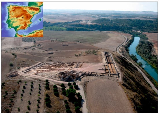
Figure 1.
An image of Reccopolis and its surrounding area and a map of its location.
This study was made possible by gathering and processing important historical cartography data from the 17th century using geographical apps. Moreover, if we add the written sources that we obtained for the medieval period to the data, the dialogue between them is key to analysing road networks, settlement patterns and vegetation, including agriculture and water resources, as well as change processes versus a long duration in the formation dynamics of historical landscapes. The aim of this study, then, was to assess which natural and/or anthropic elements have been maintained in this landscape, and since when, and which features were distorted and/or transformed, if any.
2. Theoretical and Analytical Framework for an Early Middle Ages Landscape
With the fall of the Roman Empire, most of the Iberian Peninsula’s rural area was once again restructured between the 6th and 7th centuries through various levels of settlement: villages and farms, intermediate centres of power such as the so-called hilltop sites, together with churches, monasteries and a limited number of aristocratic residences [7]. However, our case study is different given that it focuses on the foundation of a new settlement in an almost empty landscape or, at best, with no significant Roman habitats. There are three processes that clearly indicate the new organisation of the area: the transformation of the road network, the emergence of new settlements and, lastly, the modification of the agri-system [8,9].
The new road network is intrinsically linked to the other two elements, namely settlements and agriculture, given that it is a consequence of the foundation of new settlements dedicated to the exploitation and new organisation of the productive space for agriculture. However, the process involved two organisational levels. The first was the location of Reccopolis as a central hub of communication between the centre of the Iberian Peninsula and Levante, connecting the capital, Toledo, with the coast by following the left bank of the River Tagus. Second, in parallel to this reorganisation, the immediate area around Reccopolis was restructured through a series of radial pattern secondary roads that connected the main urban centre with secondary agglomerations and their associated land parcels, similar to other areas in Europe in the Early Middle Ages.
The organisation of the land was perhaps not only affected by the new road and settlement network but also by the need for a strategy to mitigate environmental difficulties, especially the aridity associated with the Dark Ages Cold Period [10]. The vegetation in the dry Mediterranean-style landscape was adapted to the steppe-like open spaces, similar to that described in nearby areas such as the Tablas de Daimiel (Ciudad Real) [11], the Castro de Peña Moñuz (Olmeda de Cobeta, Guadalajara) [12] and the Taravilla lagoon (Taravilla, Guadalajara) [13,14]. A shortage of water would have been a problem and must necessarily have affected agricultural production, which is attested to in the region by the transformation of Lake Somolinos (Guadalajara) into a wetland sometime between the 6th and 8th centuries [15] (p. 49).
The data obtained from the sampling performed in the area indicate that the Reccopolis landscape was characterised by being eminently open, given that the arboreal pollen did not exceed 40%. In addition to pines and conifers, which were the most represented taxa in the arboreal group, there was also the important presence of olive trees and trees belonging to the Quercus family (oaks, holm oaks, cork oaks), predominantly the evergreen varieties. A small number of hazelnut and walnut taxa were also documented, not exceeding 3% of the vegetation, which indicates the existence of species that had important productive and economic interest. There was also a riparian forest (ash and elm trees), representing 7% of the vegetation [9].
In relation to the steppe-like open landscape, of particular importance is the existence of the herbaceous group of the Aster family and grasses, especially Artemisia and Ephedra, which highlights the presence of pastures, as well as ruderal plants, which are also associated with cultivated fields. However, there is currently an evident absence of taxa associated with cereal crops, which is unsurprising if we consider that crops are self-pollinating species and that, in all likelihood, the fields were far from where the samples were taken.
Moreover, in connection with the foundation of the new settlement, it is highly likely that an organised process of deforestation was undertaken—possibly in large part due to the action of fires—precisely to favour the opening of new fields for agricultural and pastoral activity involving domestic livestock, with a clear predominance of ovicaprines (domestic sheep and goats). This would explain the development stage reached by the nitrophilous taxa (Plantago, Rumex, Urtica, Chenopodiaceae, Geraniaceae, Rubiaceae and Polygonaceae).
In addition to the area’s agrarian characterisation, the use of remote sensing technologies (LiDAR, thermal photography), together with infrared aerial photography, has also been key in the study of the agri-systems around Reccopolis. LiDAR technology enabled us to identify various levels of data and design a specific digital surface model (DSM). This has been especially useful in areas where the microspatial parcel division is linked to the topographical organisation by means of terraces (near the settlement of Arroyo Badujo). Traditional aerial photography is not capable of providing precise visualisation of the structure of this type of space. However, microspatial research on the Arroyo Badujo valley, combining intensive prospecting with a specific DTM-LiDAR survey of the area, has identified the outline of an aqueduct and traces of three terraced curvilinear morphological units located between Reccopolis and La Paeriza (Figure 2), in an environment where the rectangular organisation of the landscape dominates. This curvilinear morphology was already evident in the Iron Age in areas of Central and Southern France [16] (p. 22), [17] (pp. 109, 384, 523). However, in the area between Reccopolis and La Paeriza, there is no evidence of habitation prior to the 6th century, which is when the new landscape structure appeared. As a result, the relationship between the curvilinear morphological units and the new road network created when the city was founded, with the characteristic crossroads as also seen in La Paeriza, and the new settlement structure constitute the elements that support the discussion of this hypothesis.
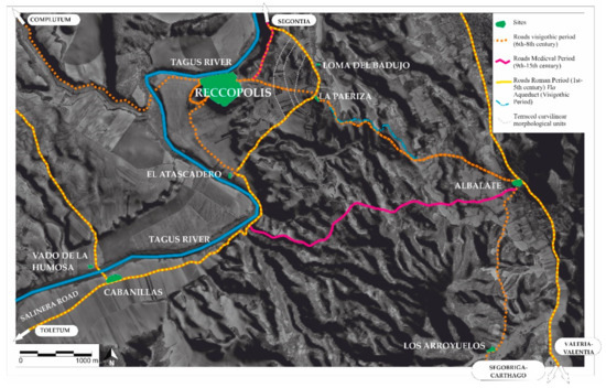
Figure 2.
Reccopolis road reorganisation around the site, 6th-century settlement pattern.
3. Methodology
The longue durée analysis [18,19] was paramount to our approach, given that our aim was to examine transformations in a specific landscape in an extended period of time—from the Early Middle Ages to the present—and to draw conclusions in two ways. The first was in reference to historical trends and patterns, which usually occur slowly and are only perceived after a few generations but define the present-day landscape of the area. The second was whether it was possible to relate the information obtained from maps to our current knowledge of the landscape during the Visigothic period using landscape archaeology.
As noted in the Introduction, historical maps were the main source of interpretation used in this study. This enabled us to analyse historical processes from multiple perspectives [20]. We considered the area’s landscape in the centre of the Iberian Peninsula with two clear parameters in mind: the present-day landscape and that created during the Visigothic period. The latter has already been reconstructed through archaeological prospection and excavation, remote sensing, archaeobiology, palynology and environmental analysis.
3.1. Study Area
Our basic unit of analysis is the so-called “Alfoz de Zorita” (Figure 3), an administrative district created in the 10th century. Although its etymology is clearly Arabic in origin, it remained in use throughout the Middle Ages and Modern Era. An “alfoz” is the rural area that surrounds a city or town and can comprise various population units, one of which acts as the capital, in this case Zorita, the nucleus that replaced Reccopolis from the 9th century onwards. The new al-Andalus settlement is in fact 800 m east of the Visigothic city. It should be noted that while we are familiar with the “alfoz” of the High Middle Ages (13th–14th century), we have to assume that it would be similar to that founded between the 9th and 10th centuries, given that Zorita maintained its undisputed status as the region’s capital from its foundation until the 15th century.
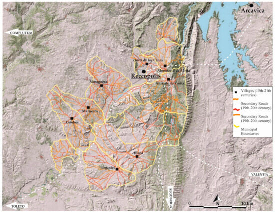
Figure 3.
Alfoz de Zorita central area: territory and historical road network.
The first time that the Alfoz de Zorita demarcation was documented in written sources was in 1124 [21], which included the villages and settlements of the present-day towns of Zorita, Illana, Aldovera, La Bujeda, Albalate, Almonacid, Yebra, Sayatón, Pastrana, Escariche, Escopete, Loranca, Hontova, Hueva, Moratilla, Valdeconcha, Fuentelaencina, Alhóndiga, Auñón and Berninches.
3.2. Sources of Information and Regression Map Analysis
To approach a study of these characteristics, it is important to highlight that historical cartography offers very diverse information that is not only found on the map itself. On numerous occasions, as will be seen, the written information attached to maps is also very valuable for the interpretation and assessment of the map’s extracted data. For this study, we performed a map regression analysis ranging from the 21st century to the medieval period. As already mentioned, although we did not use contemporary cartography and/or topographical data, we were familiar with the landscape due to previous studies. We worked backwards from more modern maps to earlier maps of the area to determine change and/or continuity and to locate former features. The entire data and indicator set was uploaded to an open-source GIS program (QGIS).
The cartographic data were processed in various ways. The data from 19th and 20th century maps were transformed from rasters into vectors. Priority was given to the construction of historical parcels, starting with the introduction of roads, including the footpath network. The 19th-century agricultural parcels were transformed into CAD format. The information provided by modern and medieval land registers was added to the cartographic base and supported with archaeological studies on specific areas, including abundant toponymic and parcel information. In some cases, however, it was not possible to perform a complete topographical reconstruction to reduce the data to the geographical locations of specific productive elements. The geographic dataset was linked to a specific MySql database. In fact, various data analysis models were designed in an ad hoc MySql structure. One of the most complex elements was managing non-quantitative data. In this regard, a first approximation was to construct a regression map model in which the data were contrasted with extensive archaeoenvironmental analyses. This enabled us to resolve questions relating to settlement patterns and the influence of the natural environment in a much broader sense.
We divided the information into six main data groups (Table 1): (1) 21st–20th century; (2) 19th century—mainly based on the “Diccionario geográfico-estadístico-histórico de España y sus posesiones de Ultramar”/Geographical-Statistical-Historical Dictionary of Spain and its overseas possessions [22]; (3) 18th century, based on the Catastro of Ensenada1 [23], which is the first microspatial representation of the geography of Spain; (4) 16–17th century, using the Relaciones topográficas de los pueblos de España, hechas de orden de Felipe II/Topographic Relations of the Towns of Spain, commissioned by Philip II [24]; (5) the medieval period (11th–13th century), based on the Diplomática Arriacense [25]; and (6) Visigothic and Islamic written sources, which provide various levels of information.

Table 1.
Documents and data used for the archaeogeographical analysis.
As explained, we decided to use a map regression analysis based on present-day landscape features to see whether it was possible to recreate the landscape of the Early Middle Ages and whether this type of analysis continues to be highly efficient in the 21st century or, in contrast, whether it has been completely superseded by more modern techniques and approaches.
The contemporary data were extracted from data available at the Spanish Geographic Institute, which reports to the Spanish Ministry of Public Works and Transport (www.cnig.es) (accessed on 13 June 2023). The advantages of using these data are numerous, including the availability of data collections and the fact that they are georeferenced in ETRS89 [26]. Freely accessible data have been available on a specific platform since 2010, which adheres to the EU INSPIRE directive, and can be combined to produce interoperable geographic information systems (GIS) and spatial data infrastructures (SDI) to provide a GIS node and geoportal and directly generate historical data with links to specific cartography from the 15th century.
The Diccionario geográfico-estadístico-histórico de España y sus posesiones de Ultramar is a geographical handbook of Spain, frequently referred to as “el Madoz”, because it was edited by Pascual Madoz [22], a Spanish politician and statistician who held various senior political positions, such as Minister of Finance, during the “Bienio Progresista” (Progressive Biennium) during the reign of Queen Isabel II of Spain. Originally published in 16 volumes between 1845 and 1850, this reference work is outstanding for its sheer amount of data, its systematic organisation and for covering the entire area of Spain. In this study, we used Volume 7, which focusses on Faba in the province of Guadalajara. The handbook proves to be an interesting basis for the identification of ancient population centres, which have subsequently been identified as archaeological sites. It also highlights abandoned buildings and spaces for social use, which provides important information for the identification of cultural heritage.
However, the use of cartography to obtain cadastral information did not emerge until the late 19th century. In addition to “el Madoz”, also particularly useful from the perspective of landscape reconstruction are the so-called “Minutas”, which include a varied set of topologies: kilometre sheets, urban plots, altimetries and boundary drawings. Together with an initial survey of population centres, most of the “Minutas” for the study area were drawn up between 1870 and 1890 prior to industrialisation. The specific treatment of this data set, in which a spatial rather than a quantitative value predominates, as in the case of the so-called ‘Bourbon cadastres’, made it necessary to design a second database to include data on the administrative geographical boundaries, water resources and constructions relating to water and land use, and other structures, some linked to religious or even heritage buildings. In addition, one of the more unusual aspects is the inclusion of so-called production buildings (bee farms, mills, warehouses, etc.) in the database, as well as the articulation of the road network based on a distinction between primary and secondary roads.
In reference to the road network and based on the “Minutas” drafted in the late 19th century, we were able to analyse the area’s road network. The development of roads enabled us to establish temporal superposition criteria closely linked to specific archaeological sites. From the analysis of the relationship between roads and sites, we observed a close relationship between medieval occupation and the organisation of the area, especially in the locations of settlements, which is particularly useful in the design of field sampling strategies. From the analysis of the relationship between roads and sites, based on the radial and linear configuration that was one of the central elements in the definition of Archaeogeography defended by the French School in the 1980s and the important work of various research groups in Spain, under the definition of Archaeomorphology [27], we were able to determine the structure of the area. In this regard, roads become a diachronic reality that can be defined as ‘[…] today’s road systems are composed of an accumulation of strata that contain indications of their history’ [28] (p. 69) within a model that operates ‘at various spatial and temporal scales’ [29,30] that have gradually been integrated into a reflection on the evolution of parcels of land as a reflection of archaeological materiality.
The analysis of the road network was neither simple nor homogeneous. A large part of the toponymic or cadastral references during the early Modern and Middle Ages lack specific spatiality. Moreover, we have data that are even more ephemeral for earlier periods.
For the 18th century, we used a large-scale census and statistical investigation from 1749 until 1756, commissioned by King Ferdinand VI of Spain and his minister the Marquis of Ensenada—known as the “Catastro de Ensenada” (Cadastre of Ensenada). It was conducted in the Crown of Castile, excluding the Basque Country, Navarre and the Crown of Aragon (fortunately, our study falls under the Crown of Castile). It includes not only geographical data, but also information about the population, territorial properties, buildings, cattle and all manner of revenue and trades. As a result, it is considered the best statistical register from the pre-statistical age of the Old Regime in Europe. This set of initiatives was maintained by successive Bourbon regimes throughout the 18th century, to which others were added, such as the “Censo del Conde de Aranda” (1768–1769) and the later “Censo de Floridablanca” (1787) [31]. Both primarily focus on demographic questions and provide fewer fiscal and cartographic data than the “Catastro de Ensenada”. One of the key aspects of the latter was the design of a specific cartography, which included “agrimensores y geómetras” (surveyors and geometers) to draft individualised maps of each of the municipalities where the data were collected. However, the results are clearly heterogeneous. The lack of an extensive corps of geographers in the mid-18th century was a major obstacle to the development of the proposed objectives. In many cases, local surveyors had to be used to gather schematic data on municipal boundaries. Fortunately, the data are detailed enough to identify their representations as roads, toponyms and urban spaces.
It should be noted that this level of information was extremely important for our study given that we organised the data on the study area in a database based on the structure of 18th-century land registers. They primarily provide economic, land use and productivity data. Toponymic data are limited and primarily refer to geographical elements; therefore, they have limited capacity to provide information on human settlements. However, the wealth of data on agricultural use, geographical characteristics and landscape development provide an evolutionary nuance that is impossible to observe in other cartographies.
For example, we were unable to obtain this type of information for the 17th century and did not find a quality data record until the 16th century, such as the “Relaciones topográficas de los pueblos de España, hechas de orden de Felipe II” [24], which provides a detailed description of the settlements in Spain during the reign of Philip II, as well as the main characteristics of the ecosystem of the Crown’s territories in the Iberian Peninsula in the 1570s. The “Relaciones topográficas” is perhaps one of the richest sources available for toponymic reconstruction, especially the “Aumentos” (a review and expansion of 16th-century data), which also undertakes minimal historical reconstruction, proposes hypotheses and mentions depopulated areas and even social and religious practices around certain spaces. It also indirectly mentions epigraphic elements, ancient roads and bridges. However, this work cannot be considered true cartography, given that it does not provide a representation of the geo/spatial reality.
However, in addition to the “Relaciones topográficas”, one of the most interesting aspects of the medieval period is how various geographers, commissioned under the Habsburg dynasty, began to represent the Iberian Peninsula. In the first representations of Castile from 1606 to 16322 [32], Alfoz de Zorita is conspicuous by its absence, or has a very limited presence. Its absence is quite significant as it underlines a fundamental issue in the area: the loss of the region’s importance during the transition to the Modern State as a result of the diminishing political and economic weight of the Order of Calatrava3 [33,34], which, until then, had been the principal political body. As a result, the area was relegated to a mere transit zone between two large areas of the southern Iberian sub-plateau, crossing the Sierra de Altomira.
The “Diplomática Arriacense” [25] is a medieval document that provides important information on the toponymy and boundaries of the Alfoz de Zorita in the late 12th century. In certain cases, some of the population centres mentioned are considered uninhabited in “el Madoz” (19th century), which leads us to defend a model of occupation that was consolidated in the High Middle Ages and maintained until the Modern Era. These elements have been cross-referenced with the results of archaeological surveys and documentation on the Alfoz de Zorita as part of the Order of Calatrava in the second half of the 16th century over an area of 800 km2. Although it can be a useful tool, direct toponymic identification entails its risks. Examples are the potential duplication of names throughout the same area and spatial ambiguity, reflected in the displacement of ‘sites’.
4. Results and Discussion
The aim of this study was not to perform a detailed analysis of the evolution of a landscape from the Middle Ages to the present day, but rather to take a methodological approach to highlight some of the key elements in its constitution. As mentioned above, our study area is located in the southeast of the present-day province of Guadalajara and is characterised by its tabular relief, which is traversed by the River Tagus and some of its tributaries. The moorland is interspersed with watercourses, opened precisely by the action of water, whose substratum was formed fundamentally by a prolonged process of endorheic sedimentation of materials eroded from the Central System Mountain Range in the northwest and the Iberian System Mountain Range in the southeast [35]. This section of the “Meseta” or plateau is relatively high, ranging from 600 MASL in the valley bottoms to 1000 MASL in the highest foothills, such as the Sierra de Altomira.
Our study area is largely defined by the presence of the middle course of the River Tagus (Figure 4), which was dammed in the early 20th century. This has affected the sedimentation process and changes in the riverbed, as well as navigability. The analysis of the 19th-century documentation gives us a glimpse of small natural modifications in the course and structure of the meanders. The level of detail in the cartography prior to the Middle Ages does not allow us to accurately measure the oscillations. However, we know that this process must have been very intense, given that the geomorphological studies that we performed in the river’s palaeo-course, in the west of the area immediately surrounding the Reccopolis site, showed that the course of the river has shifted by around 500 m (Figure 4) from the Early Middle Ages to the present day.
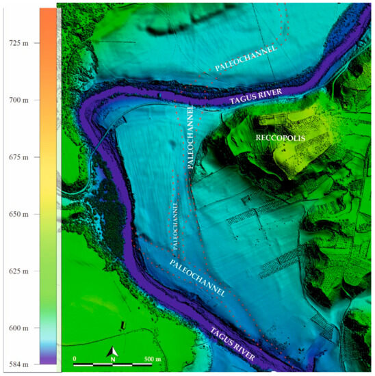
Figure 4.
Modification of the course of the River Tagus as it passes through Reccopolis.
According to the Geological Map of Spain (1:50,000, IGME), it is important to note that the area is characterised by the presence of fluvial sediments composed of gravel, sand and silt. This fact, plus the absence of evident linearity in its modification, suggests that it is not an anthropic diversion or channelling (Figure 5). There is no defined pattern, so it seems evident that it would be a natural modification of the palaeochannel, which we were able to verify by comparing LiDAR data with earlier cartography.
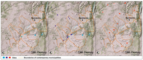
Figure 5.
Evolution of settlement patterns (12th–15th century).
Several data sources were combined for the study. On the one hand, a geomagnetic survey confirmed the fluvial origin of the palaeochannels, which was extended using geological sampling. The data were processed in QGIS, combined with a LiDAR flight specific to the area of study. Historical maps from the 19th century were also used to analyse the changes in the course of the River Tagus, which confirmed the frequent alteration of the channel as a result of floods.
One of the key elements in the study was the reconstruction of parcels and land use. In this regard, 19th-century maps made it possible to identify agricultural uses such as the traditional Mediterranean style of cultivation. In parallel, they also made it possible to determine exploitation strategies by identifying areas of wasteland and fallow land, allowing us to determine the rotation of crops. Although the medieval documentation is very generic, it did allow us to reconstruct a landscape composed of vineyards, olive trees and cereals for flour production, based on the mills on the River Tagus.
The reshaping of the landscape around the year 1880 was subsequently studied in a comparative analysis of cultivation and parcel dimensions using a panorama of land use provided by the first extensive aerial photography flights in the region, which started in 1956. In this brief window of time, less than 100 years, it is significant that a very intense process of deforestation can be observed, which suggests that the anthropogenic transformation of the ecosystem may have occurred relatively quickly and must have been very disruptive. Earlier, between 1790 and 1880, intense changes in the landscape were also evidenced through the decrease in forest cover, which was probably linked to the disentailment process. This was the auctioning of the lands belonging to the Order of Calatrava to other landowners. However, with the exception of the logical transformation of land parcels and their ownership, even today, the predominant style of agriculture is still traditional Mediterranean cultivation.
The continuity of land use, excluding forest cover, was not extended to those settlements that underwent various stages of restructuring from the Visigothic period until the 15th century. However, from the 15th century onwards, as can be seen from historical maps and contemporary sources, most of the settlements were already established and have continued to the present day.
As already highlighted, the foundation of Reccopolis had an important impact both on the creation of new nuclei and on the new road network. The rural areas linked to the city were maintained until around the 8th–10th century, when they were abandoned, and the new “medina” of Zorita was founded. It is likely that this new city led to the creation of new rural settlements in the area, which are, however, currently undetectable in archaeological records.
From the 12th century onwards, a new social landscape was constructed as a consequence of the Castilian occupation of al-Andalus. New settlements arose that played a decisive role in the control of the area and its spatial hierarchy in opposition to pressure from the Islamic state, which turned the study area into a frontier zone until the 13th century. From then on, the area was predominantly used for agriculture, which lasted until the late 14th and early 15th centuries, when a significant decline in the number of settlements saw the disappearance of around 20–30% (Figure 5).
The evolution of settlement patterns analysis was the result of developing an extensive archaeological survey programme, reviewing textual sources and processing historical maps. The latter gave rise to high-resolution model designs up to the mid-19th century. From then on, cartographic construction, in which toponymy also played a prominent role, had to be supplemented with archaeological work in the field. This consisted of archaeological surveys and, occasionally, magnetometry research. As already mentioned, all the data were processed in QGIS, which included various levels of information—for example, land use.
One of the key elements in the organisation of settlement patterns is road networks. The reconstruction of the road network, at both a micro- and macrospatial level, formed part of the reorganisation of the area during the Visigothic period. However, the process had two organisational levels. The first was the location of Reccopolis as a central hub of communication between the centre of the Iberian Peninsula and Levante, connecting the capital, Toledo, with the coast by following the left bank of the River Tagus (Figure 6). Prospecting work in the area around Reccopolis has led to the discovery of a connection between Reccopolis-Complutum (an important nucleus in Roman times) and Toledo via a well-known Iron Age II road [36], which is still visible in 19th-century cartography. At that time, it was known as the Vía Salinera, an important communication intersection between the provinces of Cuenca, through the municipality of Illana (Guadalajara), to the present-day region of Madrid [36,37,38]. Second, in parallel to the general reorganisation process, the immediate area around Reccopolis was restructured (Figure 4 and Figure 6) through a series of radial pattern secondary roads that connected the main urban centre with secondary agglomerations and their associated land parcels, similar to other areas in Europe in the High Middle Ages.
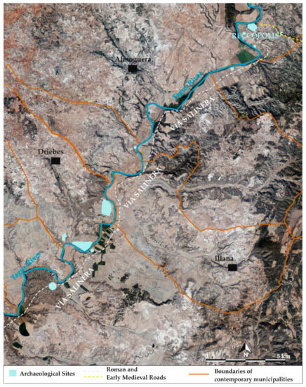
Figure 6.
The Vía Salinera, the backbone of the medieval and Visigothic territory.
The road network endured over a long period of time, from the 13th century onwards. However, although the main roads were maintained, the network also became more complex as a result of the increase in the number of settlements. The structure was modified from the 16th century onwards, as a consequence of Madrid becoming the capital city and the fact that the area was becoming more marginalised, which can be seen in the cartography of the 19th and 20th centuries.
These are some of the main results of our investigation. As we have seen throughout the study, historical cartography has proven to be an extremely useful tool for the analysis of landscape archaeology. Indeed, it provides an invaluable source of geospatial information on what the landscape looked like in the past and how human groups were distributed, allowing us to better understand the distribution of settlements, infrastructure, communication routes and other relevant cultural and natural features. In fact, several elements have been identified that provide a significant improvement when carrying out an analysis within the discipline of landscape archaeology.
- Temporal context: Historical maps show how the region was perceived in earlier times. By comparing modern maps or current satellite images with ancient ones, we have detected changes in the landscape, suggesting the presence of archaeological sites and socio-cultural changes.
- Detection of missing features: Some structures and settlements may have disappeared over time due to erosion, abandonment or new urbanisation processes. Historical maps can reveal the locations of features that are no longer visible in today’s landscape, which helps to direct archaeological investigations.
- Identification of patterns and trends: By examining historical maps from different periods, we have been able to identify settlement patterns, areas of cultivation and other relevant data. These patterns have provided valuable information on how societies interacted with the landscape and with each other.
- Planning archaeological research: Historical mapping can help archaeologists to identify areas potentially rich in archaeological remains, allowing them to plan excavations and field surveys more efficiently.
- Cultural contextualisation: Historical maps can also provide information on toponymy, historical boundaries and other cultural aspects that may be essential in understanding the historical evolution of a territory.
All these elements show that historical cartography serves as a valuable form of documentation. By preserving the maps properly and combining them with remote sensing and georeferencing technologies, accurate records of the past landscape and its relationship with archaeological sites can be analysed and preserved.
5. Conclusions
This study emphasises the usefulness, even today, of historical cartography for landscape analysis, which, in recent years, has gradually been superseded by new remote sensing technologies and other cutting-edge predictive approaches. As we have seen, historical cartography is essential in performing a longue durée analysis, which enables us to have a global perspective to detect transformations and continuities in a specific historical space. However, it is difficult to obtain a precise temporal picture given that, in general, we move in broad chronological arcs. Notwithstanding, this type of analysis, in combination with other methods, is an essential basic step in performing a landscape archaeology study. In fact, the results obtained raise new questions about the importance of the earlier ecological substratum and historical heritage as indissoluble elements in the construction of a landscape.
In our case study, we were able to verify that specific socio-political actions, such as the foundation of new settlements, led to the new organisation of the productive space and the road network that connected them. The latter, in fact, has remained practically unchanged from the Middle Ages to the present day. We also observed that, due to rotation, the types of crops grown remained practically the same. The greatest fluctuations were found in relation to population centres before the 15th century, which varied in number and location as a result of social conflicts, epidemics and moments of growth and economic stability.
In summary, historical cartography, and especially the exponential growth of digitisation, is a significant starting point in identifying and analysing anthropised landscapes and, more specifically, the perception or continuity of long-term processes in the construction of historical landscapes.
Author Contributions
Conceptualization, P.D.-B. and M.C.-P.; methodology, P.D.-B. and M.C.-P.; software, M.C.-P. and P.D.-B.; validation, P.D.-B. and M.C.-P.; formal analysis, P.D.-B. and M.C.-P.; investigation, P.D.-B. and M.C.-P.; resources, M.C.-P. and P.D.-B.; data curation, M.C.-P.; writing—original draft preparation, P.D.-B. and M.C.-P.; writing—review and editing, P.D.-B. and M.C.-P.; visualization, M.C.-P. All authors have read and agreed to the published version of the manuscript.
Funding
This research was supported by the SUBRECC project (PID2022-136708NA-I00) and the Research Group Archaeology: Landscapes, Colonialism and Cultural Heritage, at the Universidad de Alcalá (Madrid, Spain).
Institutional Review Board Statement
Not applicable.
Informed Consent Statement
Not applicable.
Data Availability Statement
Not applicable.
Acknowledgments
Pilar Diarte-Blasco is currently a Ramón y Cajal Research Fellow (RYC2018-025646-I) at Spanish National Research Council in the Department of Archaeology and Social Processes (Instituto of History, Madrid), funded by the Ministry of Science and Innovation of Spain (MICINN). This research was supported by the SUBRECC project (PID2022-136708NA-I00) Manuel Castro Priego belongs to the Research Group Archaeology: Landscapes, Colonialism and Cultural Heritage, at the Universidad de Alcalá (Madrid, Spain), which has also contributed to this research. We are grateful for the collaboration of Professor Lauro Olmo-Enciso who initiated a first approach to the study area within the Spanish Ministry of Science and Innovation project HAR2009-11627 Dynamics and Construction of the Medieval Landscape.
Conflicts of Interest
The authors declare no conflict of interest.
Notes
| 1 | |
| 2 | |
| 3 | The Order of Calatrava was a military and religious order founded in the 12th century in the Kingdom of Castile, with the initial objective of protecting the town of Calatrava, Ciudad Real. In a relatively short time, its immense human and economic resources gave the Order sweeping political and military power, which lasted until the end of the Reconquista. The order owned lands and castles all along the border between Castile and Aragon and exercised feudal lordship over thousands of vassals [33,34]. |
References
- Gillespie, S.D. Archaeological Drawing as Re-Presentations: The Maps of Complex A, La Venta, Mexico. Lat. Am. Antiq. 2011, 22, 3–36. [Google Scholar] [CrossRef]
- Sobala, M. Do historical maps show the maximal anthropopressure in the Carpathians? J. Mt. Sci. 2021, 18, 2184–2200. [Google Scholar] [CrossRef]
- Sánchez-Pinto, I. Historical Mapping vs. Archaeology: Rethinking Fort Sancti Spiritus (1527–1529). Hist. Archaeol. 2023, 57, 220–251. [Google Scholar] [CrossRef]
- Quirós Castillo, J.A. Early medieval landscapes in north-wet Spain: Local power and communities, fifth-centuries. Early Mediev. Eur. 2011, 19, 285–311. [Google Scholar] [CrossRef]
- Sánchez Pardo, J.C. Power and rural landscapes in early medieval Galicia (400–900 AD): Towards a re-incorporation of the archaeology into the historical narrative. Early Mediev. Eur. 2013, 21, 140–168. [Google Scholar] [CrossRef]
- Fernández Mier, M. Peasant Communities and Landscape Change in North-West Iberia. In Polity and Neighbourhood in Early Medieval Europe; Escalona, J., Vésteinsson, O., Stuart Brookes, S., Eds.; Brepols: Turnhout, Belgium, 2019; pp. 57–82. [Google Scholar]
- Diarte-Blasco, P. Late Antique and Early Medieval Hispania: Landscapes without Strategy? Oxbow Books: Oxford, UK, 2018. [Google Scholar]
- Olmo-Enciso, L.; Castro Priego, M.; Diarte Blasco, P. Transformación social y agrosistema en el interior peninsular durante la Alta Edad Media (s. VI-VIII d. C.): Nuevas evidencias desde Recópolis (Zorita de los Canes, Guadalajara). Lucentum 2019, 38, 355–377. [Google Scholar] [CrossRef]
- Olmo-Enciso, L.; Castro-Priego, M.; Ruiz-Zapata, B.; Gil-García, M.J.; Galindo-Pellicena, M.; Checa-Herráiz, J.; Gómez de la Torre-Verdejo, A. The Construction and Dynamics of Early Medieval Landscapes in Central Iberia. In Mediterranean Landscapes in Post Antiquity: New Frontiers and New Perspectives; Gelichi, S., Olmo-Enciso, L., Eds.; Archeopress: Oxford, UK, 2019; pp. 104–128. ISBN 978-1789691900. [Google Scholar]
- Helama, S.; Jones, P.D.; Briffa, K.R. Dark Ages Cold Period: A literature review and directions for future research. Holocene 2017, 27, 1600–1606. [Google Scholar] [CrossRef]
- Gil García, M.J.; Ruiz Zapata, M.B.; Santisteban, J.I.; Mediavilla, R.; Lopez-Parno, E.; Dabrio, C.J. Late holocene environments in Las Tablas de Daimiel (south central Iberian peninsula, Spain). Veg. Hist. Archaeobot. 2007, 16, 241–250. [Google Scholar] [CrossRef]
- Ruiz Zapata, M.B.; Gil García, M.J.; Arenas Esteban, J.; Martín Arroyo, T. El impacto del asentamiento celtibérico de Peña Moñuz (cuenca superior del Tajo) sobre el paisaje vegetal: Análisis polínico. Geogaceta 2014, 55, 83–86. [Google Scholar]
- Moreno, A.; Valero-Garcés, B.; González-Sampériz, P.; Rico, M. Flood response to rainfall variability during the last 2000 years inferred from the Taravilla Lake record (Central Iberian Range, Spain). J. Paleolimnol. 2008, 40, 943–961. [Google Scholar] [CrossRef]
- Moreno, A.; Pérez, A.; Frigola, J.; Nieto-Moreno, V.; Rodrigo-Gámiz, M.; Martrat, B.; González-Sampériz, P.; Morellón, M.; Martín-Puertas, C.; Corella, J.P.; et al. Medieval Climate Anomaly in the Iberian Peninsula reconstructed from marine and lake records. Quat. Sci. Rev. 2012, 43, 16–32. [Google Scholar] [CrossRef]
- Currás, A.; Zamora, L.; Reed, J.M.; García-Soto, E.; Ferrero, S.; Armengol, X.; Mezquita-Joanes, F.; Marqués, M.A.; Riera, S.; Julià, R. Climate change and human impact in central Spain during Roman times: High-Resolution multi-proxy analysis of a tufa lake record (Somolinos, 1280 m asl). Catena 2012, 89, 31–53. [Google Scholar] [CrossRef]
- Chouquer, G. Transmissions et transformations dans les formes parcellaires en France. Esquisse d’un schéma général d’interprétation. In Actes du Colloque “Forêt, Archéologie et Environnement” 14–16 Décembre 2004; Dupouey, J.L., Dambrine, E., Dardignac, C., Georges-Leroy, M., Eds.; l’Office National des Forêts, l’Institut National de la Recherche Agronomique et la Direction Regionale des Affaires Culturelles de Lorraine: Nancy, France, 2007; pp. 21–33. [Google Scholar]
- Watteaux, M. La Dynamique de la Planimétrie Parcellaire et des Réseaux Routiers en Vendée Méridionale. Études Historiographiques et Recherches Archéogéographiques; Université Panthéon-Sorbonne: Paris, France, 2009; p. 571. [Google Scholar]
- Braudel, F. Histoire et sciences sociales: La longue durée. Ann. Hist. Sci. Soc. 1958, 13, 725–753. [Google Scholar] [CrossRef]
- Braudel, F. El Mediterráneo y el Mundo Mediterráneo en la Época de Felipe II, 2nd ed.; Monteforte Toledo, M.; Roces, W.; Simón, V., Translators; Fondo de Cultura Económica: Madrid, Spain, 1976. [Google Scholar]
- Porro, J.M. La defensa y consolidación de las fronteras en el Septentrión novohispano: Geografía y desarrollos cartográficos (1759–1788). Anu. Estud. Am. 2011, 68, 19–50. [Google Scholar] [CrossRef]
- Ballesteros-San José, P. Hermandades en Zorita, Almoguera y sus tierras. España Mediev. 1985, 7, 973–990. [Google Scholar]
- Madoz, P.; Sánchez Zurro, D.; Sánchez Sánchez, I. Diccionario Geográfico-Estadístico-Histórico de España y sus Posesiones de Ultramar; Ámbito: Valladolid, Spain, 1985; ISBN 84-8604-790-0. [Google Scholar]
- Camarero Bullón, C. Madrid y su Provincia en el Catastro de Ensenada. Los Pueblos de Madrid 1750–1759; Ediciones del Umbral: Madrid, Spain, 2001; ISBN 978-8495-457-56-1. [Google Scholar]
- Catalina-García, J. Relaciones Topográficas de los Pueblos de España, Hechas de Orden de Felipe II, Guadalajara; Aache Ediciones: Guadalajara, Spain, 2002; ISBN 8495179792. [Google Scholar]
- Pareja Serrada, A. Diplomática Arriacense. Colección de Algunos Documentos, Publicados unos, Inéditos otros, que Pueden Servir para Planear o Ilustrar una “Historia de Guadalajara y su Provincia”; Taller Tipográfico de la Casa de Expósitos: Guadalajara, Spain, 1921. [Google Scholar]
- Potti Manjavacas, H.; Sevilla Sánchez, C.; Villalón Esquinas, M.; Sánchez Fanjul, J. SignA, el geoportal del IGN de España: Explotando lo mejor de las IDE y los SIG. Rev. Cart. 2017, 95, 111–128. Available online: https://www.revistasipgh.org/index.php/rcar/article/view/278/275 (accessed on 13 June 2023). [CrossRef]
- Palet Martínez, J.M.; Arnau, G.M.; Hèctor, A.O.R.; Alamino, T.P. Els espais altimontans pirenaics orientals a l’Antiguitat: 10 anys d’estudis en arqueologia del paisatge del GIAP-ICAC/The high mountain areas in the Eastern Pyrenees in Antiquity: 10 years of studies in landscape archaeology from GIAP-ICAC. Treb. D’arqueologia 2017, 21, 77–97. [Google Scholar] [CrossRef]
- Vion, É. L’analyse archéologique des réseaux routiers: Une rupture méthodologique, des réponses nouvelles. Paysages Découverts 1989, 1, 67–99. Available online: https://www.formesdufoncier.org/pdfs/vion.pdf (accessed on 26 April 2016).
- Watteaux, M. The Road Network in the Longue Durée: A Reading Key of the History of Territories. Open Archaeol. 2017, 3, 149–174. [Google Scholar] [CrossRef]
- Watteaux, M. Medieval Agrarian Landscapes seen by French School of Archaeogeography. In People and Agrarian Landscapes. Approaches and Methods for an Archaeology of Peasantry in the Western Mediterranean; Quirós Castillo, J.A., Narbarte Hernández, J., Eds.; Archeopress: Oxford, UK, 2022; pp. 15–51. ISBN 978-1803-274-386. [Google Scholar]
- Instituto Nacional de Estadística (INE). Censo de 1787. “Floridablanca”. Tomo II Comunidades Autónomas de la Submeseta sur; I.N.E. Artes Gráficas: Madrid, Spain, 1987; NIPO WEB: 729-16-002-2. [Google Scholar]
- Hernando, A. El mapa en España. Siglos XV–XVIII; Centro Nacional de Información Geográfica: Madrid, Spain, 1995; ISBN 84-7819-067-8. [Google Scholar]
- Ayala Martínez, C. La Orden de Calatrava, problemas de organización territorial y militar (Siglos XII-XIII). Arqueol. Territ. Mediev. 2003, 10, 157–179. [Google Scholar] [CrossRef][Green Version]
- Madrid Medina, A.; Villegas Díaz, L.R. El Nacimiento de la Orden de Calatrava. Primeros Tiempos de Expansión (Siglos XII y XIII); Instituto de Estudios Manchegos: Granada, Spain, 2009; ISBN 978-84-9915-121-2. [Google Scholar]
- González-Martín, J.A.; Vázquez González, A. Guía de los Espacios Naturales de Castilla-La Mancha; Junta de Comunidades de Castilla-La Mancha: Toledo, Spain, 1991; ISBN 84-7788-181-2. [Google Scholar]
- Abascal-Palazón, J.M. Vías de Comunicación Romanas de la Provincia de Guadalajara; Diputación de Guadalajara: Guadalajara, Spain, 1982; ISBN 843-006-3781. [Google Scholar]
- Palomero Plaza, S. Las Vías Romanas En La Provincia De Cuenca; Diputación Provincial de Cuenca: Cuenca, Spain, 1987; ISBN 84-505-6258-9. [Google Scholar]
- Álvarez González, Y.; Palomero Plaza, S. Las vías de comunicación en Madrid desde época romana hasta la caída del reino de Toledo. In Madrid del siglo IX al XI; Real Academia de Bellas Artes de San Fernando: Madrid, Spain, 1990; pp. 41–64. ISBN 84-451-0243-5. [Google Scholar]


Disclaimer/Publisher’s Note: The statements, opinions and data contained in all publications are solely those of the individual author(s) and contributor(s) and not of MDPI and/or the editor(s). MDPI and/or the editor(s) disclaim responsibility for any injury to people or property resulting from any ideas, methods, instructions or products referred to in the content. |
© 2023 by the authors. Licensee MDPI, Basel, Switzerland. This article is an open access article distributed under the terms and conditions of the Creative Commons Attribution (CC BY) license (https://creativecommons.org/licenses/by/4.0/).