Abstract
Analysis of spatial patterns and driving factors of different ethnic villages under regional integration is important for the conservation and development of ethnic villages. This article takes seven multi-ethnic villages in the Dadu River Basin of Ganzi Prefecture as an example; we employ a quantitative model of spatial syntax based on the theory of figure–ground relationship to link the tangible and intangible spaces. The results reveal the logical context and formation mechanism among the overall layout, residential architecture, and public space of the villages. The findings of this study are as follows: (1) The site of different ethnic villages reflects commonality. (2) The spatial configurations of the villages are significantly influenced by the surrounding natural environment, with significant differences. Cluster-concentrated villages exhibit the smallest expansion trend, rich spatial levels, and strong ethnic territoriality; strip-intensive villages have the largest scale and the strongest permeability; and radiation-dispersion villages have variable expansion directions and architectural relationships among residents. (3) Both of the participants’ selection behaviors and residential spaces constitute the internal structure for the ethnic culture, which is driven by the humanistic spirit and force of social order, making the spatial morphology a diversified and multi-layered characteristic. (4) The rural space has gradually changed from a single residential unit to a complex unit with multiple functions. The findings extend the scope of research to ethnic villages in watersheds and provide a theoretical and practical basis for the development of other similar rural villages.
1. Introduction
China has considerable villages and diverse nationalities with great differences in their external spatial layout, internal spatial order, architectural and structural features, social organizational structure, and religions. These villages have ethnic identities, which is meaningful for multi-ethnic preservation and cultural transmission [1]. The term “morphology” is derived from the Greek “Morphe (shape)” and “Logos (logic)”, referring to the logic of formation. The spatial morphology of ethnic villages is a combination of material, spiritual, and social space, as well as social connections and order. It is a highly integrated natural environment and a historical and humanistic setting [2,3]. However, with the continuous advancement of globalization and urbanization, these places with historical value are facing many issues, such as ecological environment disruption, traditional architecture destruction, regional culture fault, loss of spatial vitality, and fading of local identity. How to study the geographical characteristics of unique regions and preserve historical treasures and local culture has received significant attention from scholars [4,5,6]. Notably, there are very few studies on the spatial patterns of Sino-Tibetan multi-ethnic areas.
The study of spatial morphology includes urban and rural spaces. The German geographer Christaller (1933) proposed the well-known “central geography theory” based on the Center land of Southern Germany. His approach utilized hexagonal and triangular patterns to analyze settlement hierarchy and scale, laying the theoretical foundation for the advancement of the study of spatial patterns [7]. Based on this, scholars have extracted features from various regions, types, and sizes of habitation spaces seen in natural settings [8] and investigated the internal and external core factors that affect changes to these features [9]. From the 1920s to the 1960s, there were more and more studies on villages, mainly focusing on village formation, development, and planning, while the study of their spatial morphology also made great progress. A. Demangeon classified villages into two forms of aggregation and dispersion [10,11]. Tu Shuangshuang studied the settlement space by categorizing it into three types: regions, groups, and individualities [12]. Over time, some scholars have also carried out research on human social activities and localized characteristics, which enriched the study of village space. Scholars considered the impact of unique human factors on the spatial layout, morphology, and structure of villages, and human subjective perceptions have received increased attention in influencing village distribution [13,14,15]. As an agricultural country with thousands of years of civilization, China has the natural advantages of village generation and the ethnic space established over time. Breaking down administrative boundaries under the influence of multi-ethnic patterns and cultural exchange has gradually become a hot topic, and the research concept has changed to a combination of “geographic environment” and “ethnic cultural integration.” At present, scholars are mainly focused on areas with special value in the Qinghai–Tibet Plateau [16], the Western Sichuan Plain [17], the Gannan area [18], the mountainous region of southeastern Guizhou [19,20], and the Yellow River Basin [21]. More scholars analyze the internal organizational structure and functional form of settlements from the perspective of folk public space [22].
With the rise of new social and economic factors and new technologies, scholars have carried out a wealth of theoretical discussions and empirical research on rural settlement space, using multi-disciplinary theories and methods including geography, ecology, and sociology [23,24], improving the functions of rural settlements such as public service systems, production, life, ecology, and transportation, and reconstructing reasonable production, life, and ecological spaces of rural villages [25]. Moreover, cultural factors have been applied to evaluate the degree of development of villages [26], and scholars have adopted techniques such as ArcGIS element vectorization [27], virtual reality (VR) scene construction [28], and spatial genetic maps [29], to express the spatial structure of villages more intuitively.
The “figure–base relationship” as a form of spatial cognition originated in the context of Gestalt psychology and was first employed by Arnheim in Art and Visual Perception to explain the upper figure and lower base of an artwork [30]. This concept was later invoked by Norrie in his 1748 analysis of urban space in Rome, where he proposed Norrie’s map by considering buildings as “figures” and environments such as streets and open spaces as “ground” [31]. Bill Hillier and Julienne Hanson first introduced the concept of spatial syntax, which abstracts the elements of a settlement as axes, while they analyzed the logical relationships between their internal spatial organization [32]. Throughout the existing results, foreign research on spatial syntax mainly focused on the cognition of the spatial environment, morphology shaping, and wayfinding behavior in virtual complex environments [33,34]. In many studies that took towns as the case study, the combination of group structure analysis and intention map was widely used. Turner concluded through a large number of empirical studies that there was a connection between intention maps and axial maps, which can be used for the study of spatial cognition from a spatial syntactic perspective [35,36]. Bendjedidi Souhaila pointed out through the syntactic and intentional map analysis of urban public space that the visibility, characteristics, and connectivity of public space with the surrounding environment are the key factors affecting its use frequency [37]. There were fewer foreign studies on villages using spatial syntax, which was related to the specific situation of its town development. However, from the point of view of the degree of applicability of the theory and the studies that have been carried out in China, it is worth exploring the application of spatial syntax to carry out cognitive research on village spaces.
Therefore, based on the diversity of ethnic village morphology, combining the figure–ground relationship and the spatial syntax, this study takes seven typical Sino-Tibetan villages in the Dadu River Basin as examples, establishes the axial model and applies the parameters of “Integration Value”, “Connection Value”, and “Intelligibility Value” to quantify the spatial morphology. Through the analysis of the value, the villages are classified within the “Nature–Village–People” system, including the cluster, linear, and radiation-concentrated villages, encompassing a variety of economic functions, including villages dominated by traditional agricultural, diverse functions, and non-agricultural economic activities. Additionally, studying the influence of national characteristics of these villages is in order to preserve the natural features of the countryside, enhance living conditions, and enrich the study of ethnic villages in the Dadu River Basin.
2. Study Area and Method
2.1. Study Area
The Ganzi Tibetan Autonomous Prefecture (Ganzi Prefecture) is located in the southeastern part of the Tibetan Plateau between 97°22′ and 102°29′ E and 27°58′ and 34°20′ N. It is a transition zone from the Sichuan Basin to the Tibetan Plateau, with complex topography and landforms. The Dadu River is the largest tributary of the Minjiang River system in the Yangtze River Basin, with a 232.20 km long main stream in Ganzi Prefecture and a basin area of 20,000 square kilometers, including 0.62 square kilometers in Kangding and Luding (Figure 1), with a complex topography and longitudinal river valleys in the basin; hence, the spatial morphology is varied. In addition, it is a place where minority nations live together and includes ethnic culture, Tibetan Buddhism, regional belief in mountain gods, red culture, etc., which has derived custom activities with regional characteristics [38,39]. Key information on the seven ethnic villages is presented in Table 1.
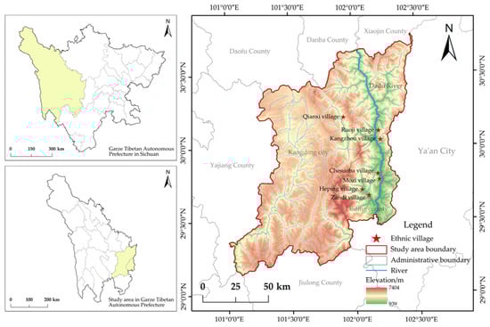
Figure 1.
Location and topography of selected ethnic villages.

Table 1.
Key information on typical ethnic villages.
To understand the demographic composition, the current state of the architecture, ethnic culture, and residents’ awareness of village space, the field research was conducted in October 2021 and March 2022, and obtained 381 questionnaires, 379 of which were valid. Analysis of the impact of the space layout of the villages on the distribution of population vitality reveals obvious differences. Combined with methods such as drone photography, the actual status information, such as the spatial layout of villages, was obtained; correct information was obtained according to image discrimination and field research, and an axis model was established.
2.2. Research Method
Spatial syntax is relatively widely used in the study of village space, and its rationality has been generally recognized through different case studies and conclusion verification [40,41]. The spatial characteristics of architectural space and public space within the village are expressed. Following the establishment of a shaft model in ArcGIS, a comprehensive analysis was conducted by Depthmap. The spatial patterns of various ethnic villages were extracted using four quantitative indexes [42,43,44,45]: global integration, local integration, connection, and intelligibility values, establishing a comprehensive framework for comprehending the relationships between elements. The integration evaluates spatial centrality via global and local values; the connection values reflect spatial connectivity, emphasizing how spatial elements link; and the intelligibility values reveal the collective impact of spatial arrangements. These indicators complement each other and focus on different aspects of spatial elements, enhancing our understanding of the spatial structure. The syntactic interpretation of the relationship between the architectural and public spaces of different ethnic villages is combined with field research, qualitative description, and quantitative data processing analysis to summarize the natural and human factors that produce their similarities and differences.
The integration value is a pivotal metric within spatial syntax, indicating the aggregation of a unit spatial element . It includes the global and local integration values. Global integration refers to the degree of centrality of the unit space from a macro perspective; this calculation indicates that the spatial element occupies a central position within the spatial configuration. The local integration quantifies the closeness between the spatial element and its neighboring spaces within a defined topological step form a localized and microscopic perspective. In summary, both the global integration and local integration present the tightness between spatial elements (integration is indicated from red to blue, from high to low in the map). Equations (1) and (2) present the calculation formulae:
where is the number of spatial nodes in the spatial system, represents the distance between and , and is the average depth value of node .
The connectivity value represents the number of node spaces in a spatial system and the number of other node spaces connected to it, which measures how interconnected a specific spatial unit is with others, revealing the mutual interactions within the spatial network. The higher the value of the space, the better the accessibility. On the contrary, the lower the value, the worse the permeability of the space, and the space is more difficult to reach. The calculation formula is shown in Equation (3):
where refers to the number of spatial units directly connected to the given spatial unit .
The intelligibility value is represented by , which reflects the consistent degree of the global and local integration values. Generally, the higher the intelligibility value, the better it is for people to establish the overall spatial structure based on the local space. The calculation formula is presented in Equation (4):
, are low, moderate, and high spatial intelligibility values, respectively [46].
3. Results
3.1. Figure–Ground Relationship Analysis
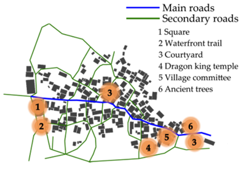
The selected villages are similar in scale, and the spatial axes and parameters of various typical village forms have similarities and differences; these are reasonably analyzed by combining the interpretation of field conditions and feature generation mechanisms. Taking the residential building space as the figure and the public space such as road space as the base, Table 2 indicates an extremely strong logical relationship between the figure and the bottom. Questionnaire analysis of the survey results reveals that these bottom spaces mainly undertake farming and business as production activities, leisure and recreational activities, and religious and cultural activities with ethnic characteristics. In Ruoji, 91% of the villagers choose the entrance of the village for leisure activities, 85% think that the construction of the village space integrates ethnic characteristics and meets the needs of daily habits, and most are willing to go to the public space in the village for activities. In Zandi and Heping, the road space along the street and the field dam become the most frequent places for villagers’ activities, and there is a plaza at the end of the road extension for villagers’ activities. In Chesuoba, the road and dam spaces become the focus of 78% of the villagers’ social activities, and the village committee is set up in Mozi, which supports the villagers’ daily business and leisure activities and has good aggregation.
Table 2.
Figure–ground relationship of typical ethnic villages.
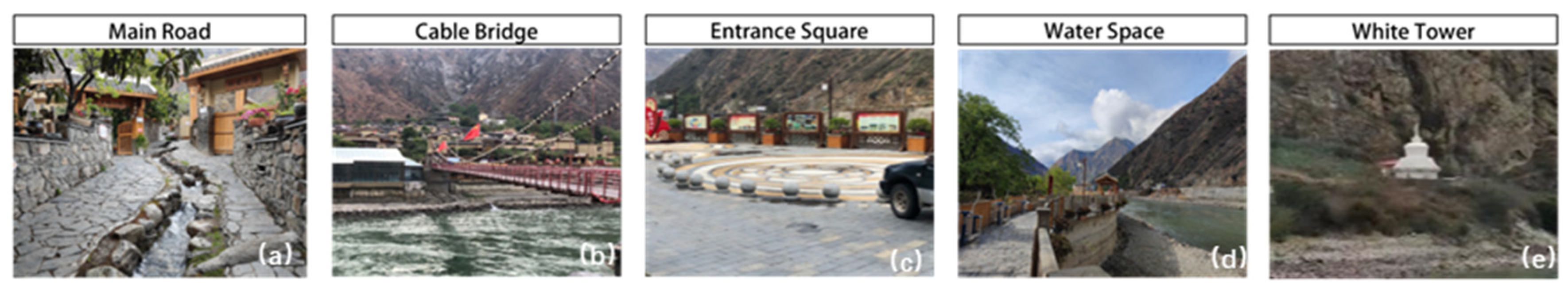
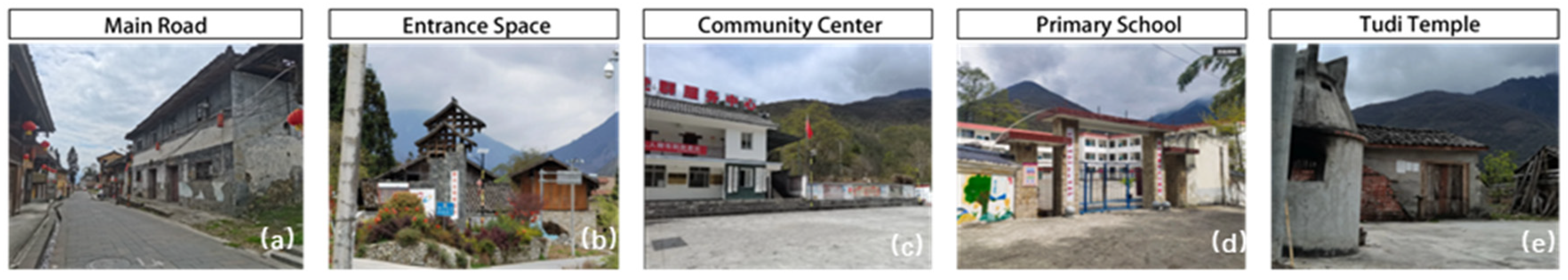
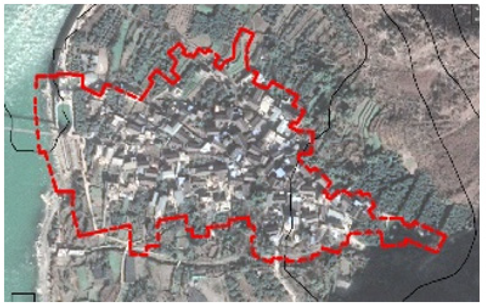
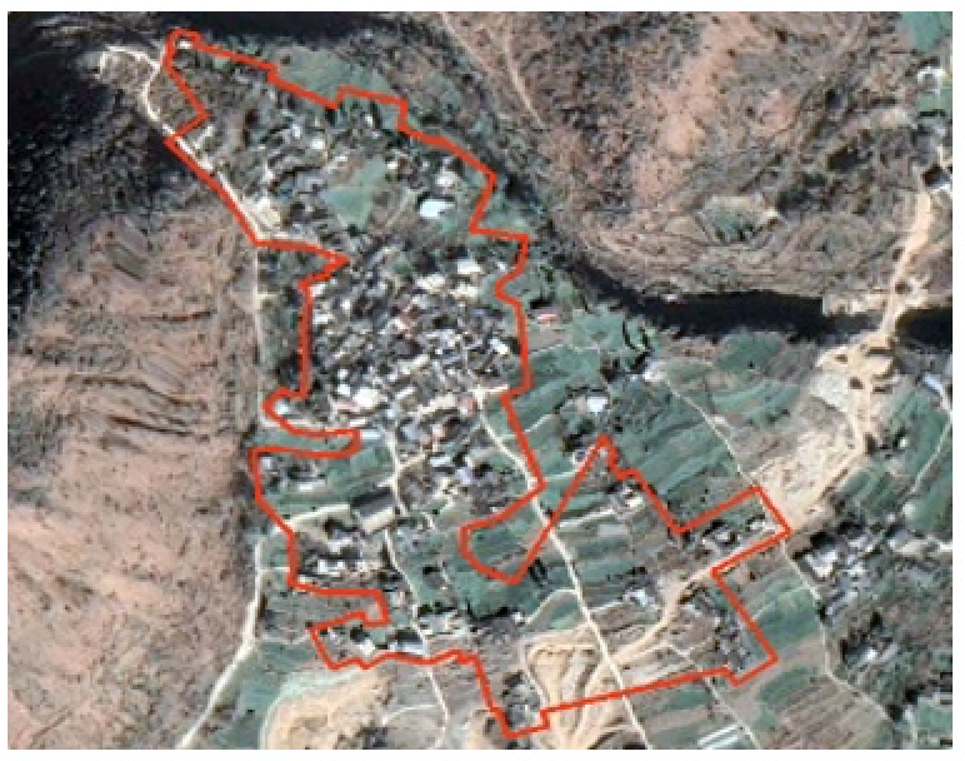
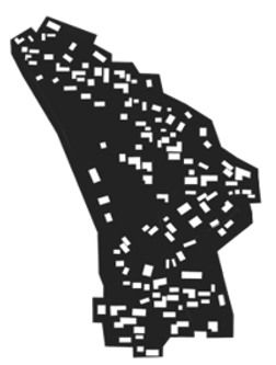
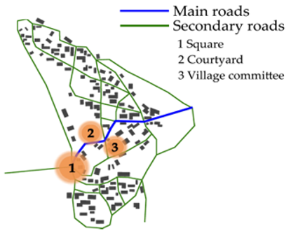
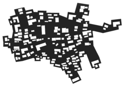
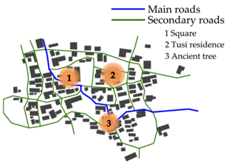
Among them, the map bases of Ruoji, Qianxi, and Kangzhou display hierarchical and identifiable characteristics. The inhabitants of this group of villages are mainly Tibetan, the form of village space is most restricted by topography, the expansion trend is the smallest, the layout is compact, residential and other spaces are closely connected, and division on the village spatial figure–ground relationship is obvious, presents the group shape, and has a certain orderliness. The residential space is concentrated in the central area, the building material is mainly stone, and square space is arranged at the entrance of the village. The production space is the “bottom”, surrounded by the “figure”, and the waterfront space is distributed along the central road and around the outermost side. All three villages have only one road into them, forming a good use of the natural environment and defense. There is a clear central space inside this type of village, and the road space is distributed from primary to secondary; the central road is about 5 m wide, and the vertical contour lines run through the whole village. The point space carrying settlement activities is along both sides of the central road, and the secondary roads are parallel to the contour line to connect the residential buildings. The important activity square is arranged in the most obvious position at the village entrance, where villagers often enter and exit, with areas and facilities that meet residents’ requirements, attracting the vitality of the crowd and enhancing residents’ sense of belonging. Owing to its special geographical environment, landscape belief is a unique regional culture preserved and inherited in the village. However, its religious space breaks the rules of other traditional villages with built-in temples and is based on the natural environment of the region, combined with the belief in Tibetan Buddhism, mountain religion, water spirits, and the principles of feng shui in nearby mountains or the more secluded places facing the water. Additionally, they have built white pagodas, the mountain cow king temples, and dragon king temples to worship and pray for blessings on specific festivals, demonstrating the nation’s respect for nature and reverence for nature; such villages spatially present certain regional characteristics (Figure 2, Figure 3 and Figure 4).
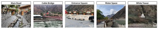
Figure 2.
Spatial elements of Ruoji.
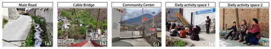
Figure 3.
Spatial elements of Kangzhou.
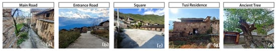
Figure 4.
Spatial elements of Qianxi.
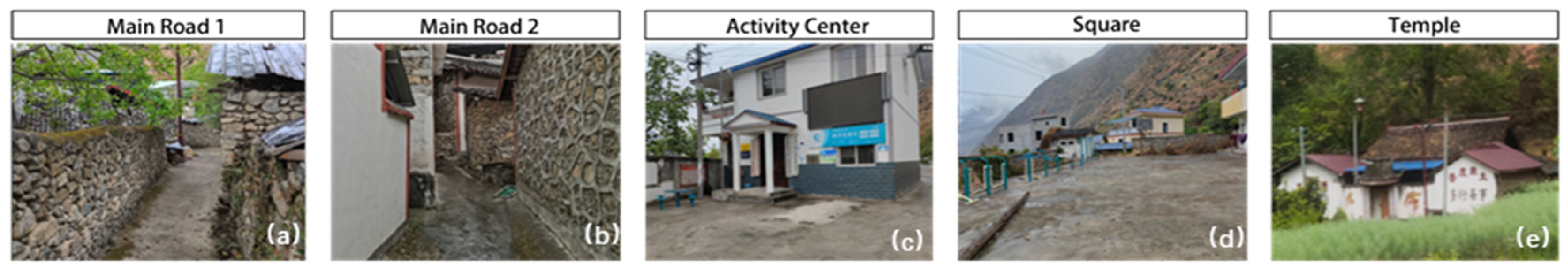
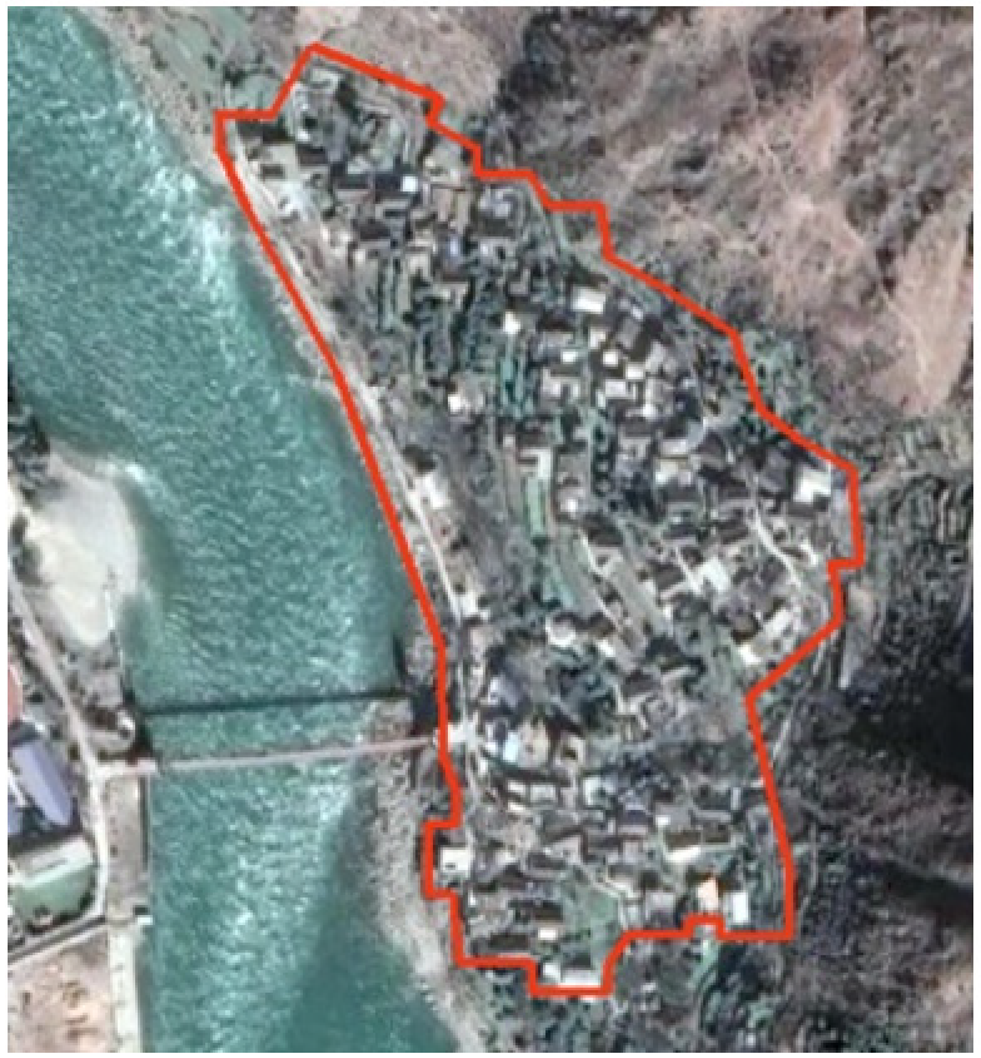
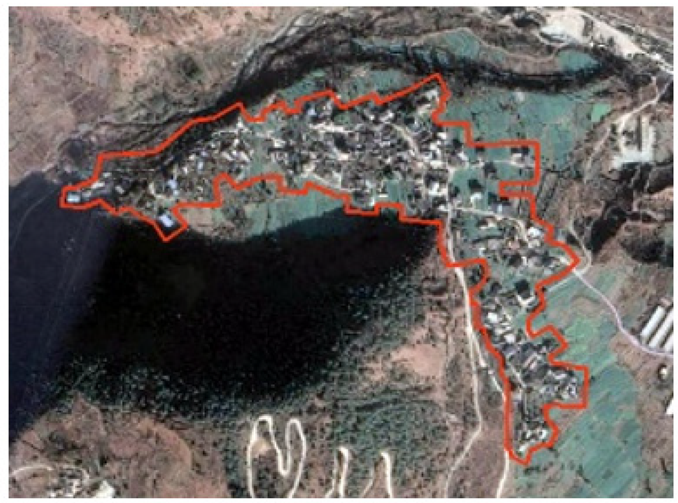
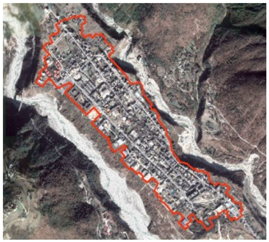
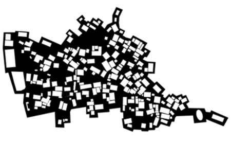
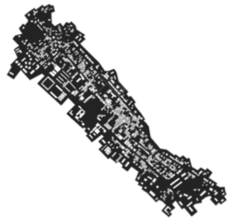
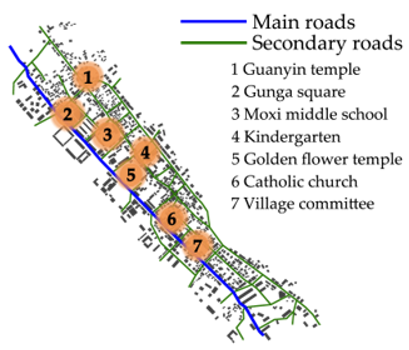
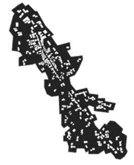
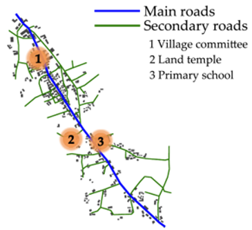
The map of Zandi and Heping shows block transitions or longitudinal extensions, with more frequent contact with the outside world and more obvious ethnic integration. Spaces like activity centers, schools, small shops, field dams, production spaces, religious spaces, and square spaces are generated in addition to the fundamental living spaces; their interactions change, exhibiting two patterns. Zandi, which has no arable land and primarily has a concentration of small businesses, comprises residential buildings, and the “bottom” is made up of other spaces. Buildings and public spaces are arranged in parallel rows on both sides of the main road, and roads are arranged in a grid-like layout with well-established facilities. Every year, there is a centralized temple fair on the 15th day of the lunar calendar and a Yi bonfire held in the main square of Gonga on the Yi New Year’s Day. On special Tibetan festivals, there is a pot-trout dance, and the sutra streamers hung by the residents can be seen everywhere on the nearby hills, which are called “Lunda” in Tibetan; each fluttering with the wind means chanting once to pray for the blessing of God. Heping village has agriculture and business industries, and its road is fishbone shaped. The block or continuous production space is the main “figure” of the village, while the residential buildings are the “bottom”, scattered in a star shape on both sides of the main and secondary roads, as well as schools, village committees, religious temples, squares, village councils, religious temples, squares, and other functional spaces, are arranged in a linear order. The east–west axis of these villages is restricted, which further strengthens the functions carried by the north–south axis and has a tendency to expand in the latter. Compared with the cluster-concentrated village of Ruoji, the carrier of the multi-ethnic characteristics of these villages has shifted from the village as the basic unit to the residential buildings, with a richer type of interface, that is, “L-shaped”, “concave”, and “Hui-shaped” forms and a blend of Tibetan rammed earth, masonry, and western Sichuan wooden structures. In terms of structure, Tibetan rammed earth, masonry, and western Sichuan wood structures are integrated, and the boundaries between the great open roads, squares, and production spaces and the very private residential buildings are clearly defined by walls and road networks or residential courtyards. Although different ethnic groups have different historical and cultural backgrounds and life patterns, they gradually form similar regional consensus and psychological behaviors, and villagers will spontaneously choose a field and dam near their residence to form a place for daily activities (Figure 5 and Figure 6).
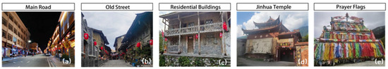
Figure 5.
Spatial elements of Zandi.
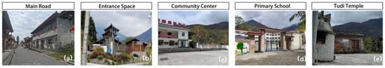
Figure 6.
Spatial elements of Heping.
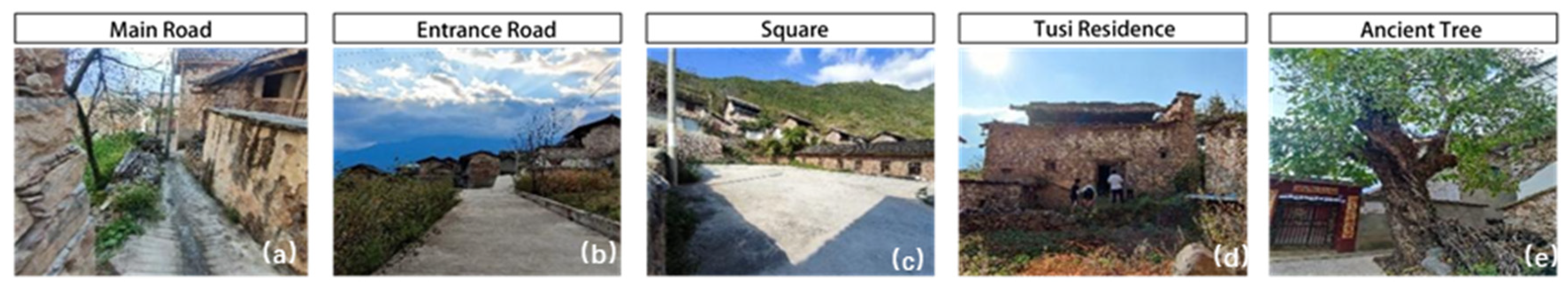
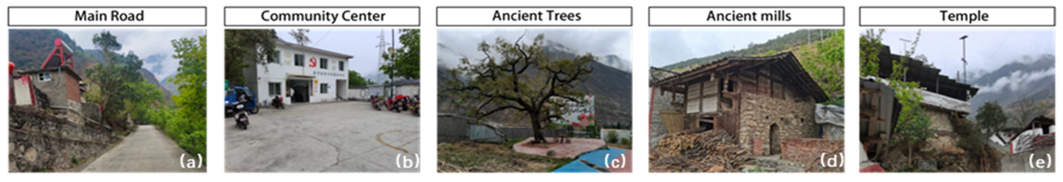
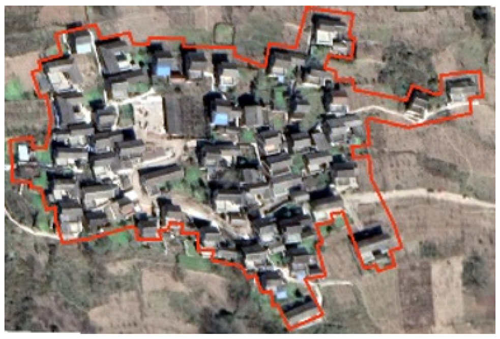
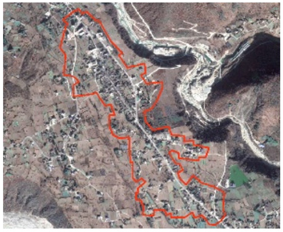
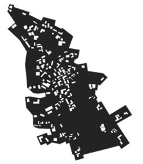
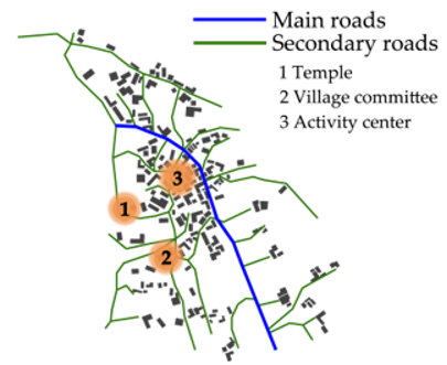
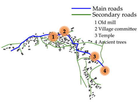
The map of Chesuoba and Mozi reveals continuity and flexible and changeable characteristics. The villages are arranged around the mountains, with a free internal spatial structure and winding roads. Moreover, the spatial morphology tends to expand outward in an indeterminate direction, influenced by the environment or by clan lineage. The map displays the relationship between the production and public spaces as the “bottom” and the residential buildings as the “figure”. The contour lines between the “bottom” and “figure” are flexible and changeable, demonstrating the characteristics of environmental adaptability and freedom. In the physical space, the new houses expanded outward by clan descendants are close to the original old village; there is no large separation phenomenon. The main buildings in Chesuoba and Mozi are connected with semi-enclosed or open courtyards, roofless vegetable gardens, or road network spaces outside to form a whole. In terms of imaginary consciousness space, residents have a sense of collective identity and self-cognitive awareness of the village spatial environment, and the village space carries the common history of local residents. For example, the living space is still closely connected to the original interior of the village. The newly built mill is adjacent to the original mill, and the stone mill from 70 years ago is preserved as a historical memorial, which gives the village its name. The spatial layout contains the spiritual thoughts of the traditional inhabitants of this land for generations (Figure 7 and Figure 8).
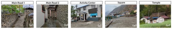
Figure 7.
Spatial Elements of Chesuoba.
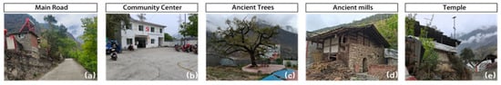
Figure 8.
Spatial elements of Mozi.
3.2. Space Syntax Analysis
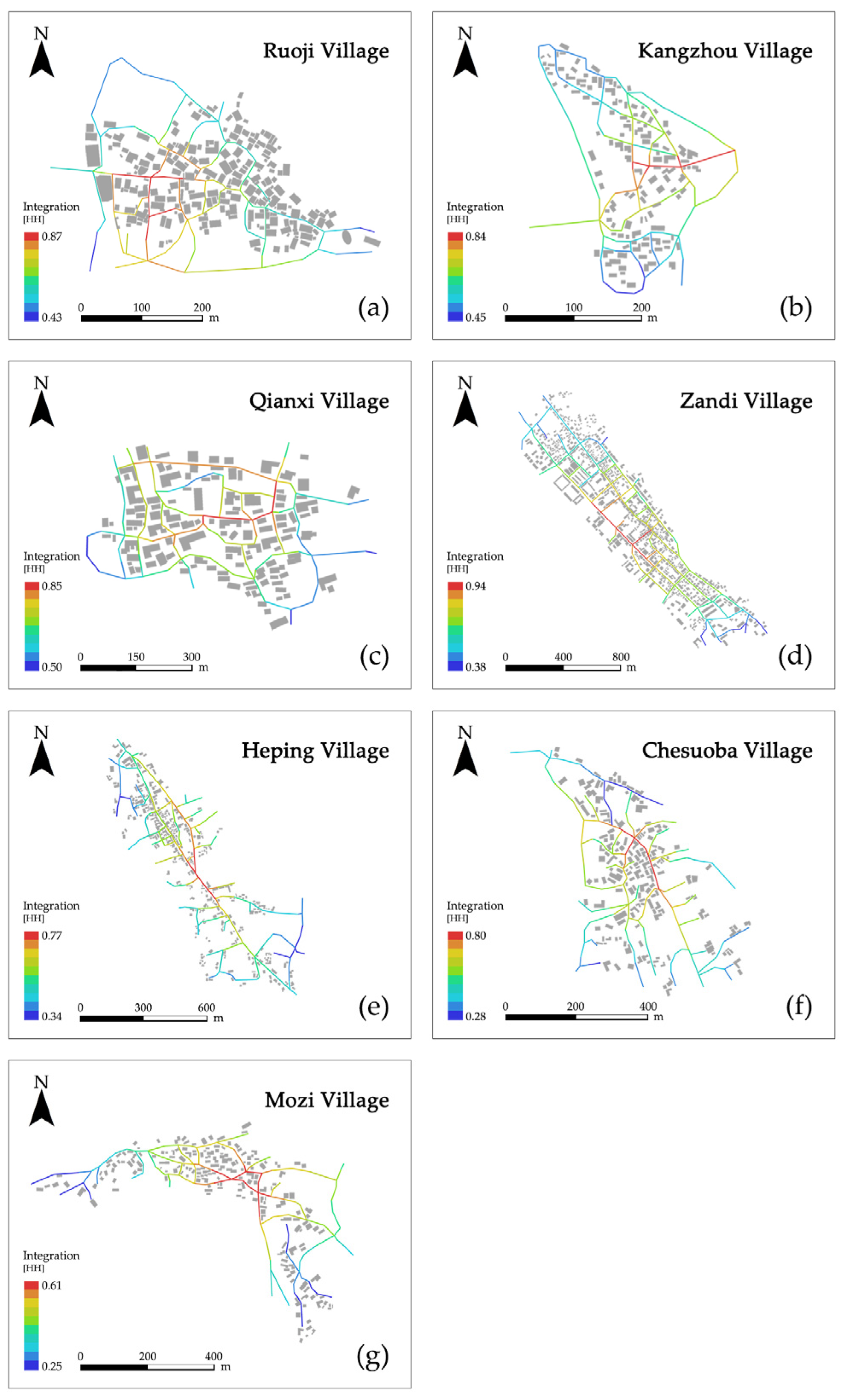
Abstracting each road as an axis and analyzing the value of integration, the results reveal that the values of the seven villages range from 0.44 to 0.68, among which the integration degree of clustered villages such as Ruoji, Kangzhou, Qianxi, and Zandi with complete road networks is higher than 0.60. The lowest value is 0.44 for Mozi, and the highest is 0.68 for Qianxi, consistent with the relationship description in the figure–ground relationship according to the field research. The highest value of node integration is 0.94 for Main Street in Zandi, where the buildings are arranged regularly, and there are several core areas along the street. Field research and syntactic analysis indicate that the areas where villagers concentrate on actual activities can have high space integration overlap values. Ruoji, Kangzhou, and Qianxi, with Tibetan characteristics as the main theme, feature local charm and attract tourists. Their residential buildings are aggregated, and the road network is distributed in layers. The highest global integration value is 0.87, all main elements are on the central through the village, high accessibility, important spatial nodes are also arranged in the vicinity, and the central road carries a variety of social, economic, and cultural functions. The village entrance is particularly important for this type of village and is usually set up as an open square, with characteristic ethnic signs, bulletin boards, and fitness equipment to enhance the resident’s sense of belonging. Mozi village is a traditional agricultural village, and its spatial arrangement is more fragmented, far from the central axis, with irregular extension and change according to the terrain, and the facilities in the village are simple, with the village committee, old mill, and temple all scattered (Figure 9, Table 3).
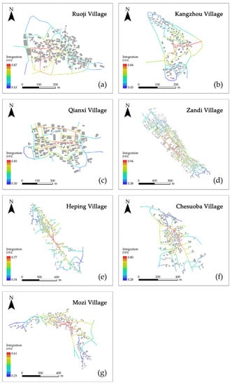
Figure 9.
Global integration values of typical ethnic villages.
Table 3.
Space syntax of typical ethnic villages.
The average connectivity values range from 2.66 to 3.59. Zandi, the largest village, exhibits the highest value of 3.59, and its road structure is a regular mesh structure with the best connection between spaces, while Chesuoba has the lowest connection value of 2.66, indicating poor connectivity. Regarding the main and secondary roads in Zandi, not only is the road network connected, but the planning is also reasonable and can carry a high volume of traffic. At both ends of the road, corresponding activity places are also set up, with complete facilities to attract residents. However, the roads in Chesuoba are mostly household roads, with a road width of 3 m, narrow, randomly arranged, poor connectivity, and can only meet the basic walking function. Additionally, the activity center along the road has not been repaired for many years, resulting in abandonment, most residents are not willing to go out, engaging in social activities mainly in their courtyards, vitality is low, and the use of road and public space is poor.
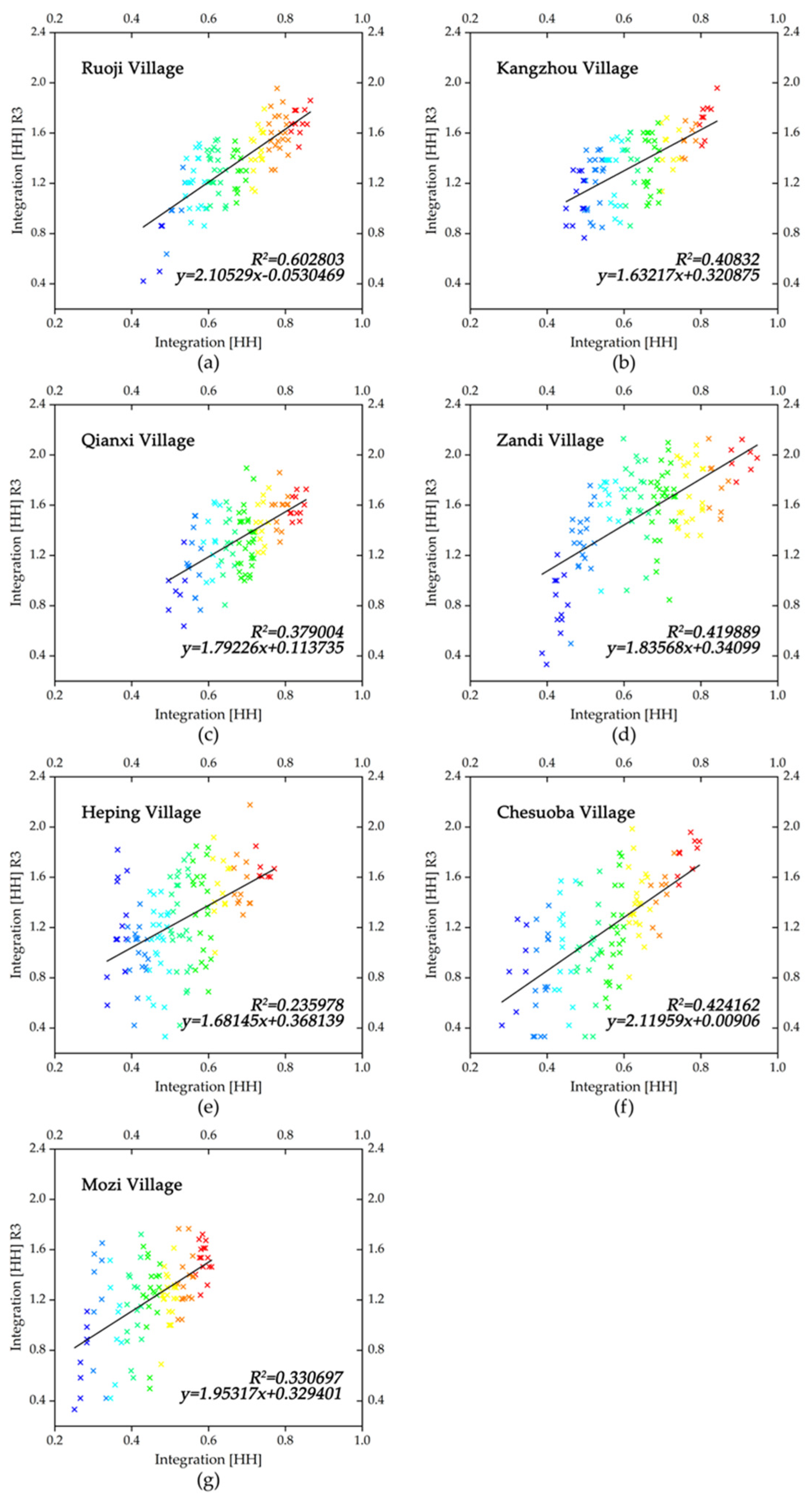
The intelligibility is measured using the coefficient of R2, represented by the correlation between global integration [HH] on the x-axis and local integration [HH] (R3) on the y-axis (“HH” signifies integration and “R3” signifies a topological radius of 3). Through the abstraction of individual road nodes as scatter points and using algorithmic analysis, a two-dimensional scatter plot is obtained, a regression line is fitted to indicate the trend of intelligibility, and scatter point colors transition from blue to red, indicating the global integration from low to high (Figure 10). The highest intelligibility value is 0.60 for Ruoji, indicating that the horizontal and vertical axes are strongly correlated, and it is easy to perceive the overall space from the local space within the village. According to the field research, the spatial integrity of Ruoji is robust, with a plunge-like stream on both sides of a steep cobbled ramp running through the village and distributed along the central road to the vicinity, which is consistent with the relationship at the bottom of the figure. The residential buildings are the most core area, showing the “main road–auxiliary road–lane” hierarchical road system and a unified architectural style. Materials are mainly Tibetan stone masonry, and decorative colors are also based on traditional Tibetan red, white, and yellow, with obvious originality and ethnic characteristics. The lowest intelligibility is 0.2 in Heping. Because of the largest village scale, the road network is irregularly herringbone shaped. The star distribution of architectural space is poorly connected, and the construction and demolition of the local residential buildings occupy more private space. The original village space changes so that residents can perceive the overall situation of space, and the global and local synchronization is low.
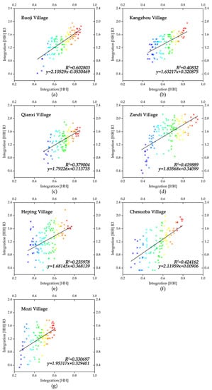
Figure 10.
Intelligibility values of typical ethnic villages.
4. Discussion
The spatial morphology of ethnic villages is fundamentally an issue of economic development and cultural inheritance. The human background and the development model have a certain influence on its morphology. Ethnic villages are often in sparsely populated areas with complex terrain, difficult to reach, and lagging in economy. The existing spatial research mainly utilizes ArcGIS technology for large-scale analysis and direct classification of objective village morphology or focuses on the relationship between the spatial distribution of villages and the thermal distribution of the population [47,48]. However, less attention is paid to the close connection between the spatial ontology of villages and the native inhabitants. Research ignores villagers’ actual use, and the cultural transmission of ethnic minorities is also disconnected. Additionally, the spatial syntax can quantitatively analyze the internal relationship of village space and present it in a parametric mode, but it remains relatively weak in studying economic functionality and temporal evolution, both of which are also crucial for the development of villages [49]. Therefore, it is necessary to combine it with others to build a more complete quantitative system and consider the relationship between nature, culture, and economic development with spatial morphology. This study further verifies the characteristics of different ethnic villages in terms of spatial morphology through spatial syntax based on the figure–ground relationship. The combination of theoretical methods and qualitative and quantitative analysis can reveal not only the relationship between village architecture and the environment but also the spatial variability of different ethnic villages from the axial model and parameter quantification. This can be combined with field research to better reflect the actual space of ethnic villages so that the spatial characteristics of villages can be analyzed more accurately and have practical significance. In the Dadu River Basin, the spatial morphology of villages has a linear correlation with the degree of ethnic integration, and the economic functions of villages also vary under different spatial morphologies, showing three types: dominance of agricultural production function, coexistence of agricultural and non-agricultural production functions, and dominance of non-agricultural production function. However, this study does not cover the development processes of the culture of villages in this region [50] and how to balance the relationship between local characteristics and the integration of multi-ethnic characteristics, which can be studied in the future.
5. Conclusions
The syntactic interpretation of ethnic village space is based on the figure–ground relationship analysis of the relationship between architectural space and spatial elements. The spatial relationships of ethnic villages of different types have large differences, which are of certain value and significance to complement the study of ethnic village spaces. Through case analysis, this study finds the following:
(1) Regional peculiarities make the different morphology of villages reflect commonality in the selection of resident sites; they prefer to follow the principle of adapting to local conditions, situating villages in locations near or around water and mountains. Moreover, the humanistic background has a profound influence on the morphology and spatial composition of villages. Additionally, there is a corresponding logical relationship between spatial elements.
(2) Due to the location of villages being mainly based on complex natural conditions, the topography plays a decisive role in the spatial morphology, and the group villages are mainly Tibetan villages with obvious hierarchical relationships at the bottom of the graph. Therefore, the road network space has a significant influence on the overall layout of the village. Reasonable road network planning can promote residents’ communication and enhance spatial vitality. The radiation-dispersion villages are dominated by Han Chinese, and the old and new villages are separated from each other and kept continuous. The preservation of traditional spiritual and cultural symbols in the construction of the new village will help form a collective self-perception and promote the sustainable construction and development of the village.
(3) Culture and religious beliefs within ethnic groups implicitly influence the village morphology. For example, a group of ethnic minorities such as Ruoji, Qianxi, and Kangzhou, the cluster village, which is dominant, has a strong ethnic consensus and a strong sense of territoriality. Compared with the other villages, the integration of multiple ethnic groups is better in the linear villages; the ethnic identity is gradually lost, but a territorial consensus is spontaneously formed as a supplement to the collective spiritual space in long-term life. Unlike the traditional villages built with clan temples, those along the Dadu River are based on the principle of respect for nature, and temples related to mountain and water gods are built in the space outside the village near the mountains or water. Although not a daily activity, worship before specific important festivals is used to show reverence.
(4) Along with the continuous development of the economy and society, the rural space has gradually changed from a single residential unit to a complex unit with multiple functions. Under the evolution of the economic functions and spatial morphology, the village pattern shows a trend of “domination of agricultural production functions to the co-existence of composite functions, and to the domination of non-agricultural production functions finally”. Traditional agrarian villages, such as Mozi and Chesuoba, are linked by blood with small spatial changes and slow economic growth. Tibetan villages, such as the Ruoji, Kangzhou, and Qianxi villages, form a core–periphery spatial change due to land constraints, utilizing local resources to develop tourism to drive the economy. Multicultural villages, such as the Zandi and Heping villages, display stronger openness and inclusiveness and expand along north–south axes, fostering diverse industries and driving economic growth.
In summary, the Han, Tibetan, and multi-ethnic villages in the Dadu River Basin all embody the fundamental belief of selecting sites near water and mountains. These villages present cluster, linear, and radiation-dispersion shapes, with the degree of ethnic integration and regional economic development directly linked to the expansion of spatial morphology, resulting in significant spatial variations in rural development patterns. Nonetheless, the exploration of morphology dynamics and economic functions is insufficient. We will gather additional data and undertake specialized research in the future. Additionally, the quantification of the internal spatial syntax of village space and the spontaneous behavior of villagers shows some deviations, which will be the space for future optimization of village construction to achieve the goal of sustainable development.
Author Contributions
Conceptualization, H.X., G.P., C.X., J.Y. and C.Y.; methodology, H.X. and C.X.; software, J.Y. and C.Y.; validation, J.Y. and C.Y.; formal analysis, H.X., C.X., J.Y. and C.Y.; investigation, H.X., C.X. and C.Y.; resources, H.X., C.X. and C.Y.; data curation, C.X. and J.Y.; writing—original draft preparation, C.X. and C.Y.; writing—review and editing, H.X. and G.P.; project administration, H.X.; funding acquisition, G.P. All authors have read and agreed to the published version of the manuscript.
Funding
This research was funded by the National Natural Science Foundation of China (grant number 42201517), Natural Science Basic Research Program of Shaanxi (Program No. 2021JQ-312).
Data Availability Statement
Data are available with the corresponding author and can be shared upon reasonable request.
Acknowledgments
The authors would like to thank the anonymous reviewers for their constructive comments on improving this research.
Conflicts of Interest
The authors declare no conflict of interest.
References
- Wang, Z. The Protection and Inheritance of the Village Culture with Chinese Minorities’ Characteristics from the Perspective of Cultural Ecology. In Proceedings of the 4th International Conference on Culture, Education and Economic Development of Modern Society (ICCESE 2020), Moscow, Russia, 19 March 2020. [Google Scholar] [CrossRef]
- Collins, J.; Nisbet, A. Theatre and Performance Design, 1st ed.; Routledge: London, UK, 2020; pp. 105–108. [Google Scholar]
- Aronoff, M.; Fudeman, K. What Is Morphology? 3rd ed.; John Wiley & Sons: Oxford, UK, 2023; pp. 1–26. [Google Scholar]
- Tan, M.; Li, X. The Changing Settlements in Rural Areas under Urban Pressure in China: Patterns, Driving Forces and Policy Implications. Urban Plan. 2013, 120, 170–177. [Google Scholar] [CrossRef]
- Qin, R.J.; Leung, H.H. Becoming a Traditional Village: Heritage Protection and Livelihood Transformation of a Chinese Village. Sustainability 2021, 13, 2331. [Google Scholar] [CrossRef]
- Mu, Q.; Aimar, F. How Are Historical Villages Changed? A Systematic Literature Review on European and Chinese Cultural Heritage Preservation Practices in Rural Areas. Land 2022, 11, 982. [Google Scholar] [CrossRef]
- Agarwal, P. Walter, Christaller: Hierarchical patterns of urbanization. Cent. Spat. Integr. Soc. Sci. 2007, 36. Available online: http://www-personal.umich.edu/~copyrght/image/books/Spatial%20Synthesis2/CSISS%20Classics%20-%20Walter%20Christaller%20Hierarchical%20Patterns%20of%20Urbanization.htm (accessed on 24 July 2023).
- Shuang, W.; Hao, J. Zoning and Mode of Rural Residential Land Consoli-Dation Based on Location Potential Theory. Trans. Chin. Soc. Agric. Eng. 2013, 29, 251–261. [Google Scholar]
- Tamás, C.; Tibor, L. Settlement Morphology of Budapest, 1st ed.; Springer: Cham, Switzerland, 2016; pp. 3–11. [Google Scholar]
- Johnston, R.; Sidaway, J.D. Geography and Geographers: Anglo-American Human Geography since 1945, 7th ed.; Routledge: London, UK, 2015; pp. 37–98. [Google Scholar]
- Dovring, F. Land and Labor in Europe 1900–1950: A Comparative Survey of Recent Agrarian History, 2nd ed.; Springer: Berlin/Heidelberg, Germany, 2013; pp. 37–131. [Google Scholar]
- Tu, S.S.; Zhou, X.Y. Research Progress and Prospect of Spatial Evolution and Optimization of Rural Settlements. Econ. Geogr. 2019, 39, 142–149. [Google Scholar] [CrossRef]
- Zhou, G.; He, Y. Dynamic Mechanism and Present Situation of Rural Settlement Evolution in China. J. Geogr. Sci. 2013, 23, 513–524. [Google Scholar] [CrossRef]
- Li, Y.; Long, Y. Spatio-temporal pattern of China’s rural development: A rurality index perspective. J. Rural. Stud. 2015, 38, 12–26. [Google Scholar] [CrossRef]
- Li, X. The Change of Rural Settlements and Their Future Development Patterns. Econ. Geogr. 2017, 37, 1–8. [Google Scholar] [CrossRef]
- Li, G.; Jiang, G. Differentiation of Spatial Morphology of Rural Settlements from an Ethnic Cultural Perspective on the Northeast Tibetan Plateau, China. Habitat Int. 2018, 79, 1–9. [Google Scholar] [CrossRef]
- Liu, W.; Henneberry, S. Socio-Cultural Roots of Rural Settlement Dispersion in Sichuan Basin: The Perspective of Chinese Lineage. Land Use Policy 2019, 88, 104162. [Google Scholar] [CrossRef]
- Li, W.; Yang, Z. Quantitative Research on the Boundary Pattern of the Rural Settlement in the High and Cold Minority Area—A Case Study of Xiahe County in Gannan Prefecture. J. Northwest Norm. Univ. (Nat. Sci.) 2019, 55, 102–108. [Google Scholar] [CrossRef]
- Lei, Y.; Zhou, H. Analysis on Spatial Characteristics and the Adaptation Mechanism of Miao Traditional Settlement in Qiandongnan, China. Math. Probl. Eng. 2022, 2022, 11. [Google Scholar] [CrossRef]
- Zhou, Z.; Jia, Z. Sustainable Mountain Village Construction Adapted to Livelihood, Topography, and Hydrology: A Case of Dong Villages in Southeast Guizhou, China. Sustainability 2018, 10, 4619. [Google Scholar] [CrossRef]
- Liu, J.; Song, Q. Spatial Morphology Evolution of Rural Settlements in the Lower Yellow River Plain: The Case of Menggang Town in Changyuan City, China. Land 2023, 12, 1122. [Google Scholar] [CrossRef]
- Liu, Z.; Zhang, F. The Causes and the Spatial Morphological Characteristics of Traditional Villages of Qiannan Shui Ethnic Group. Huazhong Archit. 2023, 41, 6. [Google Scholar] [CrossRef]
- Bhanu-Rizfa, H.; Amos, S. Bali Traditional Settlement Morphology Analysis Penglipuran, Kubu Village, Bangli Regency, Bali Province. J. Archit. Built Environ. 2016, 43, 47–54. [Google Scholar] [CrossRef]
- Cheng, J.; Yan, Y. Construction of Spatial Gene Map of Traditional Villages, Anhui Province. Planners 2022, 38, 65–71. [Google Scholar]
- Elzeni, M.M.; ELMokadem, A.A. Impact of Urban Morphology on Pedestrians: A Review of Urban Approaches. Cities 2022, 129, 103840. [Google Scholar] [CrossRef]
- He, S.; Tang, C. Research on The Relationship between The Settlement Built Environment for Rural and The Villagers’ Behavior of Spatial—A Case Study in Hunan. Archit. J. 2017, S2, 19–23. [Google Scholar]
- Ren, D.; Cao, A. Analysis of the Heterogeneity of Landscape Risk Evolution and Driving Factors Based on a Combined GeoDa and Geodetector Model. Ecol. Indic. 2022, 144, 109568. [Google Scholar] [CrossRef]
- Li, M. Protection of Ethnic Cultural Value: A Case Study of VR Scene Construction in Basha Village. Math. Probl. Eng. 2022, 2022, 9. [Google Scholar] [CrossRef]
- Liu, P.; Zeng, C. Environmental Adaptation of Traditional Chinese Settlement Patterns and Its Landscape Gene Mapping. Habitat Int. 2023, 2013, 135. [Google Scholar] [CrossRef]
- Rudolf, A. Art and Visual Perception: A Psychology of the Creative Eye, 3rd ed.; University of California Press: Berkeley, CA, USA, 1960; pp. 27–65. [Google Scholar]
- Eizenberg, E.; Sasson, O. Urban Morphology and Qualitative Topology: Open Green Spaces in High-Rise Residential Developments. Urban Plan. 2019, 4, 73–85. [Google Scholar] [CrossRef]
- Hillier, B.; Leaman, A. Space Syntax. Environ. Plan. B Plan. Des. 1976, 3, 147–185. [Google Scholar] [CrossRef]
- Hölscher, C.; Brösamle, M. Challenges in Multilevel Wayfinding: A Case Study with the Space Syntax Technique. Environ. Plan. B Plan. Des. 2012, 39, 63–82. [Google Scholar] [CrossRef]
- Farr, A.; Kleinschmidt, T. Wayfinding: A simple concept, a complex process. Transp. Rev. 2012, 32, 715–743. [Google Scholar] [CrossRef]
- Turner, A. The ingredients of an exosomatic cognitive map: Isovists, agents and axial lines? Univ. Brem. 2007, 2007, 163–180. [Google Scholar]
- Ariza-Villaverde, A.B.; Jiménez-Hornero, F.J. Multifractal analysis of axial maps applied to the study of urban morphology. Comput. Environ. Urban Syst. 2013, 38, 1–10. [Google Scholar] [CrossRef]
- Bendjedidi, S.; Bada, Y. International Review for Spatial Planning and Sustainable Development. Spat. Distrib. Pedestr. Space Cent. Tokyo 2019, 7, 108–124. [Google Scholar]
- Lang, W.; Zhou, Y.J. The Religious Culture about Jiarong Tibetan Nationality of Village Community: From Shen Village of Dadu River. Tibet. Stud. 2015, 3, 74–80. [Google Scholar]
- Zheng, L. Feasibility Study on Poverty Alleviation and Development through Tourism in the Dadu River Basin. J. Leshan Teach. Coll. 2015, 30, 42–47. [Google Scholar] [CrossRef]
- Wu, D. Introduction of Related Theories to Space Syntax. J. World Archit. 2015, 11, 18–23. [Google Scholar]
- Dettlaff, W. Space Syntax Analysis–Methodology of Understanding the Space. PhD Interdiscip. J. 2014, 1, 283–291. [Google Scholar]
- Qin, X.; Du, X. Spatial Evolution Analysis and Spatial Optimization Strategy of Rural Tourism Based on Spatial Syntax Model. A Case Study of Matao Village in Shandong Province, China. Land 2023, 12, 317. [Google Scholar] [CrossRef]
- Kelkou, L.R.; Chougui, A. Structural qualities of urban space revealed by spatial representation and intelligibility readings: The case of Setif City, Algeria. Rev. Bras. Gest. Urbana 2022, 2022, 14. [Google Scholar] [CrossRef]
- Safizadeh, M.; Maghsoodi-Tilaki, M.J. Smart city and spatial configuration: Assessing accessibility and intelligibility to increase mobility in the George Town heritage site, Malaysia. Open House Intern. 2022. [Google Scholar] [CrossRef]
- Xia, X.; Lu, X. Spatial Distribution Characteristics and Influencing Factors of Traditional Villages in Northern Guangxi Based on Spatiotemporal Big Data and Spatial Syntax. J. Landsc. Res. 2022, 14, 59–62. [Google Scholar]
- Huang, Y.; Zhang, Z. Optimization Strategies of Commercial Layout of Traditional Villages Based on Space Syntax and Space. Resistance Model: A Case Study of Anhui Longchuan Village in China. Buildings 2023, 13, 1016. [Google Scholar] [CrossRef]
- Bian, J.; Chen, W. Spatial Distribution Characteristics and Influencing Factors of Traditional Villages in China. Int. J. Environ. Res. Pub. Health 2022, 19, 4627. [Google Scholar] [CrossRef]
- Yang, R.; Xu, Q. Spatial Distribution Characteristics and Optimized Reconstruction Analysis of China’s Rural Settlements during the Process of Rapid Urbanization. J. Rural Stud. 2016, 47, 413–424. [Google Scholar] [CrossRef]
- Yang, X.; Kong, Z. Research on the Spatial Pattern of Traditional Villages Based on Spatial Syntax: A Case Study of Baishe Village. In Proceedings of the IOP Conference Serie: Earth Environment Science, Kuala Lumpur, Malaysia, 12 April 2019. [Google Scholar] [CrossRef]
- Chen, W.; Yang, L. Spatio-Temporal Characteristics and Influencing Factors of Traditional Villages in the Yangtze River Basin: A Geodetector Model. Herit. Sci. 2023, 11, 111. [Google Scholar] [CrossRef]


Disclaimer/Publisher’s Note: The statements, opinions and data contained in all publications are solely those of the individual author(s) and contributor(s) and not of MDPI and/or the editor(s). MDPI and/or the editor(s) disclaim responsibility for any injury to people or property resulting from any ideas, methods, instructions or products referred to in the content. |
© 2023 by the authors. Licensee MDPI, Basel, Switzerland. This article is an open access article distributed under the terms and conditions of the Creative Commons Attribution (CC BY) license (https://creativecommons.org/licenses/by/4.0/).