
Grounded in the Landscape—Climate Action, Well-Being and Public Space in a Small Town in the Lisbon Metropolitan Area


Abstract
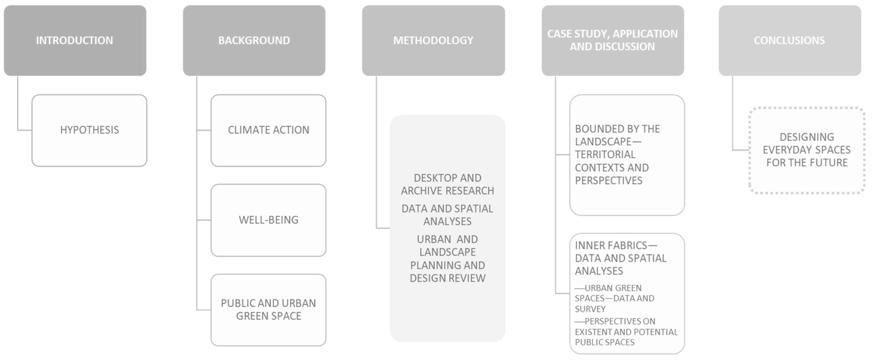
:1. Introduction
“The discourse and practices of landscape urbanism builds directly upon the canon of regional environmental planning, from the work of Patrick Geddes and Benton MacKaye to Lewis Mumford to Ian McHarg, yet remains distinct from that genealogy through the synthesis of design culture, ecology, and urbanisation” [5].
2. Background: Climate Action, Well-Being and Public Space
Heat is a rapidly growing health risk due to burgeoning urbanisation, an increase in high-temperature extremes and demographic changes in countries with ageing populations [11].
A.2.7 In urban areas, observed climate change has caused adverse impacts on human health, livelihoods and key infrastructure. Hot extremes have intensified in cities. Urban infrastructure, including transportation, water, sanitation and energy systems, have been compromised by extreme and slow-onset events, with resulting economic losses, disruptions of services and negative impacts to well-being. Observed adverse impacts are concentrated amongst economically and socially marginalised urban residents. (high confidence) {2.1.2} (Summary for Policymakers [15]).
3. Methods and Materials
- —
- —
- —
- Long-term observation and documentation make it possible to fill gaps from an ethnomethodological perspective [6,7,8,9,10,11,12,13,14,15,16,17,18,19,20,21,22,23,24,25,26,27,28,29,30,31,32,33,34,35,36,37,38,39,40,41]—(6) empirical identification and mapping of “existing and potential public spaces—typologies, continuities and management”; (7) photography and diary/personal notebook (see Section 1, Section 2, Section 4 and Section 5).
4. Case Study, Application and Discussion
4.1. Bounded by the Landscape—Territorial Contexts and Perspectives
4.2. Inner Fabrics—Data and Spatial Analyses
4.2.1. Urban Green Spaces—Data and Survey
4.2.2. Perspectives on Existent and Potential Public Spaces—Typologies, Continuities and Management
5. Conclusions: Designing Everyday Spaces for the Future
Author Contributions
Funding
Data Availability Statement
Acknowledgments
Conflicts of Interest
References
- Rybczynski, W. A Clearing in the Distance: Frederick Law Olmsted and America in the 19th Century; Scribner: New York, NY, USA, 2003; ISBN 978-0-684-86575-1. [Google Scholar]
- McHarg, I.L. Design with Nature, 25th ed.; John Wiley & Sons, Inc.: New York, NY, USA; Chichester, UK; Brisbane, Australia; Toronto, ON, Canada; Singapore, 1992; ISBN 978-0-471-11460-4. [Google Scholar]
- Forman, R.T.T. Land Mosaics: The Ecology of Landscapes and Regions; Cambridge University Press: Cambridge, UK; New York, NY, USA, 1995; ISBN 978-0-521-47462-7. [Google Scholar]
- Waldheim, C. The Landscape Urbanism Reader; Princeton Architectural Press: New York, NY, USA, 2012; ISBN 978-1-56898-439-1. [Google Scholar]
- Waldheim, C. Landscape as Urbanism: A General Theory; Princeton University Press: Princeton, NJ, USA, 2016; ISBN 978-0-691-16790-9. [Google Scholar]
- de Solà-Morales i Rubió, M. Las Formas de Crecimiento Urbano; Universitat Politècnica de Catalunya: Barcelona, Spain, 1997. [Google Scholar]
- Busquets, J. La Urbanización Marginal; Universitat Politècnica de Catalunya, Edicions UPC: Barcelona, Spain, 1999; ISBN 84-8301-325-8. [Google Scholar]
- Font, A. L’explosión de la Ciudad: Transformaciones Territoriales en las Regiones Urbanas de la Europa Meridional; Ministerio de Vivienda: Madrid, Spain, 2007; ISBN 978-84-96387-25-6.
- Morgado, C.S.A.P. Protagonismo de la Ausencia Interpretación Urbanística de la Formación Metropolitana de Lisboa Desde lo Desocupado; Universitat Politècnica de Catalunya: Barcelona, Spain, 2005; ISBN 978-84-689-3468-6. [Google Scholar]
- Powers, R. The Overstory, 1st ed.; W. W. Norton & Company: New York, NY, USA, 2018; ISBN 978-0-393-63552-2. [Google Scholar]
- WMO. Heatwaves Show Importance of Health Early Warnings and Action Plans. Available online: https://public.wmo.int/en/media/news/heatwaves-show-importance-of-health-early-warnings-and-action-plans (accessed on 19 July 2023).
- Keith, L.; Meerow, S.; Berke, P.; DeAngelis, J.; Jensen, L.; Trego, S.; Schmidt, E.; Smith, S. American Planning Association Plan Integration for Resilience Scorecard (PIRS) for Heat. Available online: https://ghhin.org/resources/plan-integration-for-resilience-scorecard-pirs-for-heat/ (accessed on 19 July 2023).
- Lancet Countdown 2022 Global Report of the Lancet Countdown. Available online: https://www.lancetcountdown.org/2022-report/ (accessed on 19 July 2023).
- The Lancet Countdown 2.2.3 Urban Green Space. 2022. Available online: https://www.lancetcountdown.org/data-platform/adaptation-planning-and-resilience-for-health/2-2-climate-information-services-for-health/2-2-3-urban-green-space (accessed on 19 July 2023).
- Calvin, K.; Dasgupta, D.; Krinner, G.; Mukherji, A.; Thorne, P.W.; Trisos, C.; Romero, J.; Aldunce, P.; Barrett, K.; Blanco, G.; et al. IPCC, 2023: Climate Change 2023: Synthesis Report. Contribution of Working Groups I, II and III to the Sixth Assessment Report of the Intergovernmental Panel on Climate Change, 1st ed.; Core Writing Team, Lee, H., Romero, J., Eds.; Intergovernmental Panel on Climate Change (IPCC): Geneva, Switzerland, 2023. [Google Scholar]
- European Union. Territorial Agenda 2030: A Future for All Places, a Future for Rural Areas. Available online: https://territorialagenda.eu/ (accessed on 27 July 2023).
- Direção-Geral do Território (DGT) Programa da Iniciativa Nacional Cidades Circulares. 2020. Available online: https://cidadescirculares.dgterritorio.gov.pt/pages/os-plai (accessed on 27 July 2023).
- Direção-Geral Do Território (DGT) InC2 Iniciativa Nacional Cidades Circulares. Available online: https://cidadescirculares.dgterritorio.gov.pt/pages/os-plai (accessed on 27 July 2023).
- INE. Objetivos de Desenvolvimento Sustentável—Agenda 2030 Indicadores Para Portugal—2015–2022; Instituto Nacional de Estatística, I.P.: Lisboa, Portugal, 2023; ISBN 978-989-25-0642-5. [Google Scholar]
- CNADS, OBSERVA, MARE, Objetivos de Desenvolvimento Sustentável—Plataforma Municipal (LocalSDG-Municipal Platform on Sustainable Development Goals). Available online: https://odslocal.pt/?lang=EN&municipality_code=oeiras&tblang=default&x=y%3Flang%3DPT (accessed on 28 July 2023).
- Divisão de Gestão Ambiental, Departamento de Ambiente e Qualidade de; Rodrigues, S.; Leitão, D.; Breu, S.; Grupo de Planeamento de Ação Local. Plano Local de Ação Integrada (PLAI) do Projeto CApt2—Circularidade da Água—Por Todos e Para Todos (Oeiras); Redes Cidades Circulares: Oeiras, Portugal, 2023; p. 48. [Google Scholar]
- Lefebvre, H.; Nicholson-Smith, D. The Production of Space, 33rd ed.; Blackwell Publishing: Malden, MA, USA, 2013; ISBN 978-0-631-18177-4. [Google Scholar]
- Saito, Y. Aesthetics of the Everyday. In The Stanford Encyclopedia of Philosophy; Zalta, E.N., Ed.; Metaphysics Research Lab, Stanford University: Stanford, CA, USA, 2021. [Google Scholar]
- Relph, E.C. Place and Placelessness; Research in Planning and Design, Réimpression Datée de 2008 Avec une Nouvelle Préface par L’auteur; Pion: London, UK, 2008; ISBN 978-0-85086-176-1. [Google Scholar]
- Carmona, M. The “Public-Isation” of Private Space—Towards a Charter of Public Space Rights and Responsibilities. J. Urban. Int. Res. Placemak. Urban Sustain. 2021, 15, 133–164. [Google Scholar] [CrossRef]
- Gehl, J. Life between Buildings: Using Public Space; Island Press: Washington, DC, USA, 2011; ISBN 978-1-59726-827-1. [Google Scholar]
- Low, S. Why Public Space Matters, 1st ed.; Oxford University Press: New York, NY, USA, 2023; ISBN 978-0-19-754373-3. [Google Scholar]
- Madanipour, A. Rethinking Public Space; Rethinking Urban and Regional Studies Series; Edward Elgar Publishing: Cheltenham, UK, 2023; ISBN 978-1-80088-457-1. [Google Scholar]
- Mehta, V. The New Proxemics: COVID-19, Social Distancing, and Sociable Space. J. Urban Des. 2020, 25, 669–674. [Google Scholar] [CrossRef]
- ThankCunha, J.d.C.; Morgado, S.; da Costa, E.M. Towards Healthier Cities. Urban Green Spaces (UGS) in the Neighbourhood of Benfica, Lisbon. In Proceedings of the 57th ISOCARP World Planning Congress Planning Unlocked: New Times, Better Places, Stronger Communities, Doha, Qatar, 28–29 October 2021; Piotr Lorens, N.B., Magidimisha, H.H., Eds.; ISOCARP—International Society of City and Regional Planners: Haia, The Netherlands, 2021; pp. 670–680. [Google Scholar]
- De Haas, W.; Hassink, J.; Stuiver, M. The Role of Urban Green Space in Promoting Inclusion: Experiences From the Netherlands. Front. Environ. Sci. 2021, 9, 618198. [Google Scholar] [CrossRef]
- Marques da Costa, E.; Kállay, T. Impacts of Green Spaces on Physical and Mental Health; EU, URBACT: Paris, France, 2020. [Google Scholar]
- Andersen, D. Narrative Ethnography; Routledge Handbooks Online: London, UK, 2020; ISBN 978-0-367-33634-9. [Google Scholar]
- Harvey, D. The Right to the City. Int. J. Urban Reg. Res. 2003, 27, 939–941. [Google Scholar] [CrossRef]
- Brenner, N.; Marcuse, P.; Mayer, M. (Eds.) Cities for People, Not for Profit: Critical Urban Theory and the Right to the City; Routledge: London, UK, 2011; ISBN 978-0-203-80218-2. [Google Scholar]
- Mousie, J. Henri Lefebvre’s “Right to the City”: Key Elements and Objections. In The Palgrave Handbook of Environmental Politics and Theory; Jay Kassiola, J., Luke, T.W., Eds.; Environmental Politics and Theory; Springer International Publishing: Cham, Switzerland, 2023; pp. 407–426. ISBN 978-3-031-14346-5. [Google Scholar]
- Garfinkel, H. Ethnomethodology’s Program. Soc. Psychol. Q. 1996, 59, 5–21. [Google Scholar] [CrossRef]
- Günel, G.; Varma, S.; Watanabe, C. A Manifesto for Patchwork Ethnography. Available online: https://culanth.org/fieldsights/a-manifesto-for-patchwork-ethnography (accessed on 5 December 2022).
- Mlynář, J. Harold Garfinkel and Edward Rose in the Early Years of Ethnomethodology. J. Hist. Behav. Sci. 2023, 59, 171–192. [Google Scholar] [CrossRef] [PubMed]
- Saint Arnault, D.; Sinko, L. Comparative Ethnographic Narrative Analysis Method: Comparing Culture in Narratives. Glob. Qual. Nurs. Res. 2021, 8, 23333936211020720. [Google Scholar] [CrossRef]
- Whittle, A.; Wilson, J. Ethnomethodology and the Production of History: Studying ‘History-in-Action’. Bus. Hist. 2015, 57, 41–63. [Google Scholar] [CrossRef]
- Ribeiro, O. Portugal, o Mediterrâneo e o Atlântico; Letra Livre: Lisbon, Portugal, 2021; ISBN 978-989-8268-50-1. [Google Scholar]
- George, P.; Morgado, S. Area Metropolitana de Lisboa 1970–2001: De La Monopolaridad a La Matricialidad Emergente. In L’explosión [sic] de la Ciudad: Transformaciones Territoriales en las Regiones Urbanas de la Europa Meridional = The Explosion of the City: Territorial Transformations in the South Europe Urban Regions; Font Arellano, A., Ed.; Ministerio de Vivienda: Madrid, Spain, 2007; pp. 62–85. ISBN 84-96387-25-9. [Google Scholar]
- Willett, J.; Lang, T. Peripheralisation: A Politics of Place, Affect, Perception and Representation. Sociol. Rural. 2018, 58, 258–275. [Google Scholar] [CrossRef]
- Font, A.; Llop, C.; Vilanova, J.M. La Construcció del Territori Metropolità: Morfogènesi de la Regió Urbana de Barcelona; Mancomunitat de Municipis, Àrea Metropolitana de Barcelona: Barcelona, Spain, 1999; ISBN 978-84-930080-5-5. [Google Scholar]
- Font, A. Design and Governance for the Barcelona City Region. In The Routledge Handbook of Regional Design; Routledge Taylor & Francis Group: New York, NY, USA, 2021; pp. 226–227. ISBN 978-0-429-29026-8. [Google Scholar]
- CMO. Oeiras Interativa Portal de Dados Abertos de Oeiras. Available online: https://oeirasinterativa.oeiras.pt/dadosabertos/ (accessed on 11 July 2023).
- INE/Statistics Portugal Censos. 2021. Available online: https://censos.ine.pt/xportal/xmain?xpgid=censos21_main&xpid=CENSOS21&xlang=pt (accessed on 11 July 2023).
- Pereira, M. O Processo de Decisão na Política Urbana. O Exemplo da Costa do Sol. Ph.D. Thesis, FCSH-UNL, Lisbon, Portugal, 1994. [Google Scholar]
- André, P.; Marat-Mendes, T.; Rodrigues, P. Alfred-Donat Agache Urban Proposal For Costa Do Sol. From the Territory to the City. In Proceedings of the 15th International Planning History Society Conference, Sao Paulo, Brazil, 15–18 July 2012. [Google Scholar]
- Marat-Mendes, T.; Mourão, J.; d’Almeida, P.B. Access to Water in the Lisbon Region in 1900. Water Hist. 2016, 8, 159–189. [Google Scholar] [CrossRef]
- Tostões, A. Monsanto, Parque Eduardo VII, Campo Grande: Keil Do Amaral, Arquitecto Dos Espaços Verdes de Lisboa; Edições Salamandra: Lisboa, Portugal, 1992; ISBN 978-972-689-044-7. [Google Scholar]
- Morgado, S. Lisboa: Um Território Em Formação; Caleidoscópio: Casal de Cambra, Portugal, 2015; ISBN 978-989-658-164-0. [Google Scholar]
- IFLA SGJA Winner—Gonçalo Ribeiro Telles. 2013. Available online: https://www.iflaworld.com/sgja-2013-winner (accessed on 29 July 2023).
- CML/Lisbon City Council Relatório Da Proposta De Plano do Plano Diretor Municipal De Lisboa. 2012. Available online: https://www.lisboa.pt/fileadmin/download_center/normativas/regulamentos/urbanismo/Regulamento_PDM.pdf (accessed on 3 July 2023).
- Barreto, A.V.; Ramos, M.S. Queijas, Estudo de Aptidão, 1962; Biblioteca de Arte Gulbenkian, Lisboa, Catalogue references: CFT169.235; CFT169.236; CFT169.237; CFT169.238; CFT169.239; CFT169.240; CFT169.241; CFT169.242; CFT169.243; CFT169.244; CFT169.245; CFT169.246; CFT169.870; CFT169.871; CFT169.872; CFT169.873; CFT169.235; CFT169.236; CFT169.237; CFT169.238; CFT169.239; CFT169.240; CFT169.241; CFT169.242; CFT169.243; CFT169.244; CFT169.245; CFT169.246; CFT169.870; CFT169.871; CFT169.872; CFT169.873. Available online: https://www.biblartepac.gulbenkian.pt/ipac20/ipac.jsp?uri=full=3100024~!190566~!172&profile=ba (accessed on 22 May 2023).
- Andresen, T.; Tostões, A.; Ramos, M.S.; Martins, A.A.; Leitão, A.A. Do Estádio Nacional ao Jardim Gulbenkian: Francisco Caldeira Cabral e a Primeira Geração de Arquitectos Paisagistas, 1940–1970; Fundação Calouste Gulbenkian, Serviço de Belas Artes: Lisboa, Portugal, 2003; ISBN 978-972-678-034-2. [Google Scholar]
- DPGU-Departamento de Planeamento e Gestão Urbanística/CMO; Sector do Património Construído/CMO. Plano de Salvaguarda Do Património Construído e Ambiental Do Concelho de Oeiras; Câmara Municipal de Oeiras: Oeiras, Portugal, 1999; ISBN 972-9145-92-X. [Google Scholar]
- Crispim, M.N.; Lobo, P.V. (Eds.) Retratos de Oeiras; Publicações DSA: Oeiras, Portugal, 1994. [Google Scholar]
- Rocha, F.I.L.C.S.; Câmara Municipal de Oeiras, Departamento de Planeamento e Gestão Urbanística—Sector de Património Construído; Equipa que elaborou o Plano de Salvaguarda do Património Contruído e Ambiental do Concelho de Oeiras. Oeiras. O Património—A História; Câmara Municipal de Oeiras: Oeiras, Portugal, 1996; ISBN 972-9145-87-3. [Google Scholar]
- de Ferreira, M.M.R. História de Oeiras: Uma Monografia, 1147–2003; Câmara Municipal de Oeiras: Lisboa, Portugal, 2003; ISBN 978-972-8490-30-0. [Google Scholar]
- Arquivo Municipal de Oeiras (Catalogue Reference) Processo DM 605: Antiga Estrada Militat Sacavém/Caxias (Título Manuscrito) 1974 a 1982 (Collection of Documents, Some of Which Hand-Written).
- Salvado, S. (Ed.) Memorial Histórico ou Colecção de Memórias Sobre Oeiras. Desde seu Princípio, Como Lugar e Cabeça de Julgado, e Depois Vila. Com o Título de Condado e Cabeça de Concelho; Edição da Câmara Municipal de Oeiras: Oeiras, Portugal, 1982; Volume II. [Google Scholar]
- A Quinta Real de Caxias. Available online: https://www.oeiras.pt/-/a-quinta-real-de-caxias (accessed on 9 May 2023).
- Planta Da Minas e Encanamentos Daagua Do Almoxarifado de Caxias, [Lisboa], 1901—Biblioteca Nacional Digital. Available online: https://purl.pt/1752 (accessed on 9 May 2023).
- Rodrigues, A.D. Quinta Real de Caxias: História, Conservação e Restauro; Beloto, C., Ed.; Câmara Municipal: Oeiras, Portugal, 2009; ISBN 978-989-608-098-3. [Google Scholar]
- Leitão, D. Os Impactos dos Fenómenos Naturais nos Aglomerados Urbanos—As Cheias e as Vagas de Calor. Available online: https://cidadescirculares.dgterritorio.gov.pt/pages/artigo-info-26 (accessed on 27 July 2023).
- Gabinete do Desenvolvimento Municipal/CMO. Oeiras, Factos e Números; Município de Oeiras: Oeiras, Portugal, 2009; ISBN 978-989-608-096-9. [Google Scholar]
- Municípia, S.A.; Gabinete de Desenvolvimento Municipal/CMO; Gabinete de Sistemas de Informação Geográfica, CMO. Oeiras, Factos e Números. Edição Especial; Edição do Município de Oeiras: Oeiras, Portugal, 2013; ISBN 978-989-608-163-8. [Google Scholar]
- Morgado, S.; de Cunha, J.C. Viver em Queijas. Narrativas da Vida Numa Vila; (Dataset and Report). Available online: https://zenodo.org/record/8061376 (accessed on 5 July 2023).
- Buhayar, N. How ‘Work from Home’ Became ‘Work from Anywhere’. 2021. Available online: https://www.bloomberg.com/news/storythreads/2021-02-04/how-work-from-home-became-work-from-anywhere (accessed on 5 July 2023).
- Long, J.; Reuschke, D. Daily Mobility Patterns of Small Business Owners and Homeworkers in Post-Industrial Cities. Comput. Environ. Urban Syst. 2021, 85, 101564. [Google Scholar] [CrossRef]
- Reuschke, D.; Clifton, N.; Fisher, M. Coworking in Homes—Mitigating the Tensions of the Freelance Economy. Geoforum 2021, 119, 122–132. [Google Scholar] [CrossRef]
- Morais, I.; Martins, N.; Correia, S.; Santos, C.; Montanha, C.; Domingos, M.M.; Neto, P. Oeiras, Vida Com Mais Verde. Edição Especial Espaços Verdes; Câmara Munic: De Oeiras, Oeiras, Portugal, 2021. [Google Scholar]
- Van Herzele, A.; Wiedemann, T. A Monitoring Tool for the Provision of Accessible and Attractive Urban Green Spaces. Landsc. Urban Plan. 2003, 63, 109–126. [Google Scholar] [CrossRef]
- Jennings, V.; Bamkole, O. The Relationship between Social Cohesion and Urban Green Space: An Avenue for Health Promotion. Int. J. Environ. Res. Public Health 2019, 16, 452. [Google Scholar] [CrossRef]
- Bedimo-Rung, A.L.; Mowen, A.J.; Cohen, D.A. The Significance of Parks to Physical Activity and Public Health. Am. J. Prev. Med. 2005, 28, 159–168. [Google Scholar] [CrossRef] [PubMed]
- Whitford, V. “City Form and Natural Process”—Indicators for the Ecological Performance of Urban Areas and Their Application to Merseyside, UK. Landsc. Urban Plan. 2001, 57, 91–103. [Google Scholar] [CrossRef]
- Santana, P.; Nogueira, H.; Santos, R.; Costa, C. Avaliação Da Qualidade Ambiental Dos Espaços Verdes No Bem-Estar e Na Saúde. In A Cidade e a Saúde; Santana, P., Ed.; Edições Almedina: Coimbra, Portugal, 2007; pp. 219–237. [Google Scholar]
- Cunha, J.d.C. Espaços Verdes Urbanos de Proximidade e Cidade Saudável: Uma Leitura a Partir da Freguesia de Benfica—Lisboa. Master Thesis, Universidade de Lisboa, IGOT, Lisboa, Portugal, 2022. [Google Scholar]
- Allen, C.D.; Macalady, A.K.; Chenchouni, H.; Bachelet, D.; McDowell, N.; Vennetier, M.; Kitzberger, T.; Rigling, A.; Breshears, D.D.; Hogg, E.H.; et al. A Global Overview of Drought and Heat-Induced Tree Mortality Reveals Emerging Climate Change Risks for Forests. For. Ecol. Manag. 2010, 259, 660–684. [Google Scholar] [CrossRef]
- Pretzsch, H.; Schütze, G.; Uhl, E. Resistance of European Tree Species to Drought Stress in Mixed versus Pure Forests: Evidence of Stress Release by Inter-Specific Facilitation. Plant Biol. 2013, 15, 483–495. [Google Scholar] [CrossRef]
- Nowak, M.J. Is the Pandemic a Hope for Planning? Two Doubt. Plan. Theory 2022, 21, 14730952221131872. [Google Scholar] [CrossRef]
- Servillo, L.; Atkinson, R.; Smith, I.; Russo, A.; Sýkora, L.; Demaziere, C.; Hamdouch, A. TOWN—Small and Medium-Sized Towns. Available online: https://www.espon.eu/programme/projects/espon-2013/applied-research/town-%E2%80%93-small-and-medium-sized-towns (accessed on 28 August 2022).
- Pultrone, G. Urban Regeneration as an Opportunity of Social Innovation and Creative Planning in Urban Peripheries. Techne 2017, 14, 139–146. [Google Scholar] [CrossRef]
- Durrant, D.; Lamker, C.; Rydin, Y. The Potential of Post-Growth Planning: Re-Tooling the Planning Profession for Moving beyond Growth. Plan. Theory Pract. 2023, 24, 287–295. [Google Scholar] [CrossRef]
- Departamento de Ordenamento do Território e Planeamento Urbano—Divisão de Ordenamento do Território Instrumentos de Gestão do Território: Plano Diretor Municipal (PDM) 2022: Planta de Ordenamento—2023 (Urban Planning Document) Oeiras. Município de Oeiras. Available online: https://oeirasinterativa.oeiras.pt/dadosabertos/dataset/?tags=Planta+de+Ordenamento-documentos (accessed on 14 July 2023).
- CMO. Instrumentos de Gestão do Território: Plano Diretor Municipal (PDM) 2022: Documentos. Oeiras. Available online: https://oeirasinterativa.oeiras.pt/dadosabertos/dataset/plano-diretor-municipal-pdm-2022-documentos (accessed on 14 July 2023).
- UIA Union Internationale Des Architectes—International Union of Architects. Available online: https://www.uia-architectes.org/en/ (accessed on 20 August 2023).
- National Center for Environmental Health; Widerynski, S.; Schramm, P.; Conlon, K.; Noe, R.; Grossman, E.; Hawkins, M.; Nayak, S.; Roach, M.; Hilts, A.S. The Use of Cooling Centers to Prevent Heat-Related Illness: Summary of Evidence and Strategies for Implementation; National Center for Environmental Health; p. 36. Available online: https://www.cdc.gov/climateandhealth/docs/UseOfCoolingCenters.pdf (accessed on 20 July 2023).
- WE ACT for Environmental Justice NYC Cooling Centers. Available online: https://www.weact.org/campaigns/nyc-cooling-centers/ (accessed on 20 August 2023).
- Apur, Atelier Parisien D’urbanisme Parcours et Îlots de Fraîcheur à Paris. Available online: https://www.apur.org/fr/nos-travaux/parcours-ilots-fraicheur-paris (accessed on 20 August 2023).
- Ajuntament Barcelona Superilles/Supermanzana. Available online: https://ajuntament.barcelona.cat/superilles/es/ (accessed on 20 August 2023).
- Ajuntament de Barcelona Xarxa de Refugis Climàtics, Barcelona Pel Clima. Available online: https://www.barcelona.cat/barcelona-pel-clima/ca/barcelona-respon/accions-concretes/xarxa-de-refugis-climatics (accessed on 8 August 2023).
- Magrinyà, F.; Mercadé-Aloy, J.; Ruiz-Apilánez, B. Merging Green and Active Transportation Infrastructure towards an Equitable Accessibility to Green Areas: Barcelona Green Axes. Land 2023, 12, 919. [Google Scholar] [CrossRef]
- Ayuntamiento de Sevilla El Cartuja Qanat. Available online: https://www.sevilla.org/actualidad/noticias/2022/el-ayuntamiento-inaugura-cartuja-qanat-un-proyecto-de-transformacion-urbana-basado-en-tecnologias-bioclimaticas-innovadoras-con-un-modelo-que-se-enmarca-en-la-estrategia-municipal-de-lucha-contra-el-cambio-climatico-y-que-aspira-a-ser-replicado-en-otros (accessed on 20 August 2023).
- DR Resolução Da Assembleia Da República n.o 100/2023, de 4 de Agosto|DR. Available online: https://diariodarepublica.pt/dr/detalhe/resolucao-assembleia-republica/100-2023-216714699 (accessed on 14 August 2023).
- De Castro Mazarro, A.; George Kaliaden, R.; Wende, W.; Egermann, M. Beyond Urban Ecomodernism: How Can Degrowth-Aligned Spatial Practices Enhance Urban Sustainability Transformations. Urban Stud. 2023, 60, 1304–1315. [Google Scholar] [CrossRef]
- Regime Jurídico dos Instrumentos de Gestão Territorial. Available online: https://dre.pt/legislacao-consolidada/-/lc/105297982/view?p_p_state=maximized (accessed on 21 April 2021).
- Tree Canopy and Forest Management|Portland.Gov. Available online: https://www.portland.gov/trees/tree-canopy-forest-management (accessed on 30 July 2023).


| Data Reference Period | Place of Residence | Total Resident Population | Rate of Change of Resident Population | Population Density | Youth Dependency Ratio | Elderly Dependency Ratio |
|---|---|---|---|---|---|---|
| N. | (%) | (Inhab./km2) | N. | N. | ||
| 2011 | Portugal (1) | 10,562,178 | 1.99 | 114.5 | 22.53 | 28.80 |
| Oeiras (2) | 172,120 | 6.16 | 3751.3 | 23.59 | 29.30 | |
| Queijas (3) | 36,288 | 18.31 | 4512.5 | 26.39 | 30.70 | |
| 2021 | Portugal (1) | 10,343,066 | −2.07 | 112.15 | 20.21 | 36.79 |
| Oeiras (2) | 171,658 | −0.27 | 3742.27 | 22.92 | 38.88 | |
| Carnaxide and Queijas (3) | 36,079 | −0.58 | 4095.23 | 25.76 | 35.88 |
| Data Reference Period | Age Groups | Number of Residents | Proportion | ||||
|---|---|---|---|---|---|---|---|
| Resident Individuals | Gender | Resident Individuals | Gender | ||||
| Male | Female | Male | Female | ||||
| 2011 | 0 to 14 years | 26,559 | 13,683 | 12,876 | 15% | 7.95% | 7.48% |
| 15 to 24 years | 16,533 | 8463 | 8070 | 10% | 4.92% | 4.69% | |
| 25 to 64 years | 96,059 | 44,269 | 51,790 | 56% | 25.72% | 30.09% | |
| 65 and older | 32,969 | 13,722 | 19,247 | 19% | 7.97% | 11.18% | |
| Total | 172,120 | 80,137 | 91,983 | 100% | 46.56% | 53.44% | |
| 2021 | 0 to 14 years | 24,317 | 12,577 | 11,740 | 14% | 7.33% | 6.84% |
| 15 to 24 years | 17,864 | 9167 | 8697 | 10% | 5.34% | 5.07% | |
| 25 to 64 years | 88,229 | 40,971 | 47,258 | 51% | 23.87% | 27.53% | |
| 65 and older | 41,248 | 16,866 | 24,382 | 24% | 9.83% | 14.20% | |
| Total | 171,658 | 79,581 | 92,077 | 100% | 46.36% | 53.64% | |
Disclaimer/Publisher’s Note: The statements, opinions and data contained in all publications are solely those of the individual author(s) and contributor(s) and not of MDPI and/or the editor(s). MDPI and/or the editor(s) disclaim responsibility for any injury to people or property resulting from any ideas, methods, instructions or products referred to in the content. |
© 2023 by the authors. Licensee MDPI, Basel, Switzerland. This article is an open access article distributed under the terms and conditions of the Creative Commons Attribution (CC BY) license (https://creativecommons.org/licenses/by/4.0/).
Share and Cite
Morgado, S.; Cunha, J.d.C. Grounded in the Landscape—Climate Action, Well-Being and Public Space in a Small Town in the Lisbon Metropolitan Area. Land 2023, 12, 1687. https://doi.org/10.3390/land12091687
Morgado S, Cunha JdC. Grounded in the Landscape—Climate Action, Well-Being and Public Space in a Small Town in the Lisbon Metropolitan Area. Land. 2023; 12(9):1687. https://doi.org/10.3390/land12091687
Chicago/Turabian StyleMorgado, Sofia, and Jeanna de Campos Cunha. 2023. "Grounded in the Landscape—Climate Action, Well-Being and Public Space in a Small Town in the Lisbon Metropolitan Area" Land 12, no. 9: 1687. https://doi.org/10.3390/land12091687
APA StyleMorgado, S., & Cunha, J. d. C. (2023). Grounded in the Landscape—Climate Action, Well-Being and Public Space in a Small Town in the Lisbon Metropolitan Area. Land, 12(9), 1687. https://doi.org/10.3390/land12091687