1. Introduction
Chile’s historical trajectory, shaped by territorial conquests and nation-building, has left a profound mark on the collective identity and geography of the nation. Following Chile’s victory in the War of the Pacific against Peru and Bolivia (1878–1883) [
1], the nation annexed territories in southern Peru and southwestern Bolivia. This territorial expansion culminated in Chile’s formal claim to the Atacama Desert in 1929. This process entailed the imposition of a homogeneous Chilean identity (known as the Chileanization process) on the local population and triggered radical changes within Andean communities [
2,
3]. As a result, along with a process of proletarianization, there was a substantial uptick in migration from the Andean highlands to Chilean coastal cities such as Iquique and Arica as people sought improved life opportunities [
2,
4]. In turn, these processes altered the socio-ecological dynamics within the highlands, a region used for pastoralism, which has long played an integral role in facilitating the diversification of production spaces across various ecological strata (the coast, central valleys, and highlands) [
5].
One of the consequences of these transformations has been the gradual and ongoing depopulation of the highlands. Historical censuses in 1883, 1892, and 1943 suggested that the Aymara population remained stable until the mid-20th century [
6]. Other sources show that between 1650 and 1850, the Aymara population in the semiarid Andes of Tarapacá experienced a considerable increase, followed by a notable decline from 1850 to 1960 [
7,
8]. This decrease was primarily attributed to mass migration to the Atacama lowlands, driven by the flourishing nitrate industry, which required a large labor force. Additionally, this period coincided with the Chileanization process.
The depopulation trend escalated further in the 1970s due to a complex interplay of geopolitical, social, economic, and environmental factors [
9,
10,
11]. These factors encompassed the intensification of the Chileanization process during the military dictatorship, a shift from traditional livelihoods to wage-based employment, and the emergence of new trade and transportation sectors. Furthermore, social pressures and the pursuit of opportunities, influenced by changing land tenure, unfavorable economic conditions, and inadequate basic services in the highlands [
12], further exacerbated depopulation trends, substantially affecting long-established Andean communities in the region [
13,
14,
15].
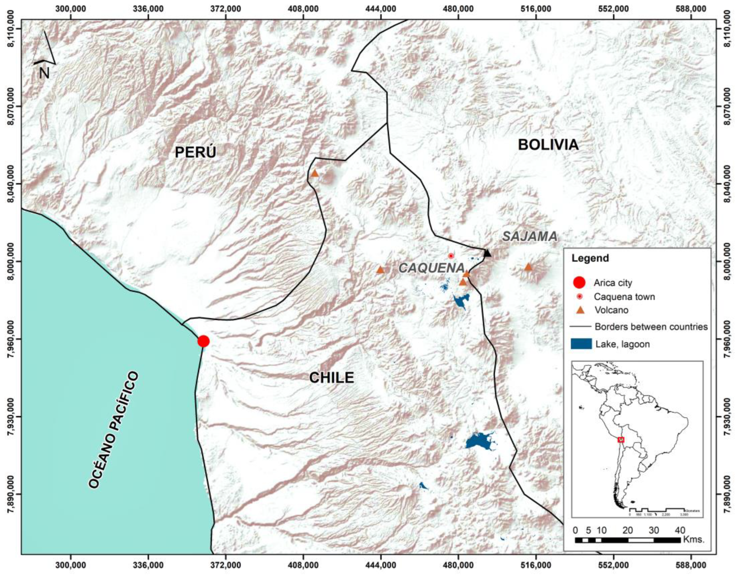
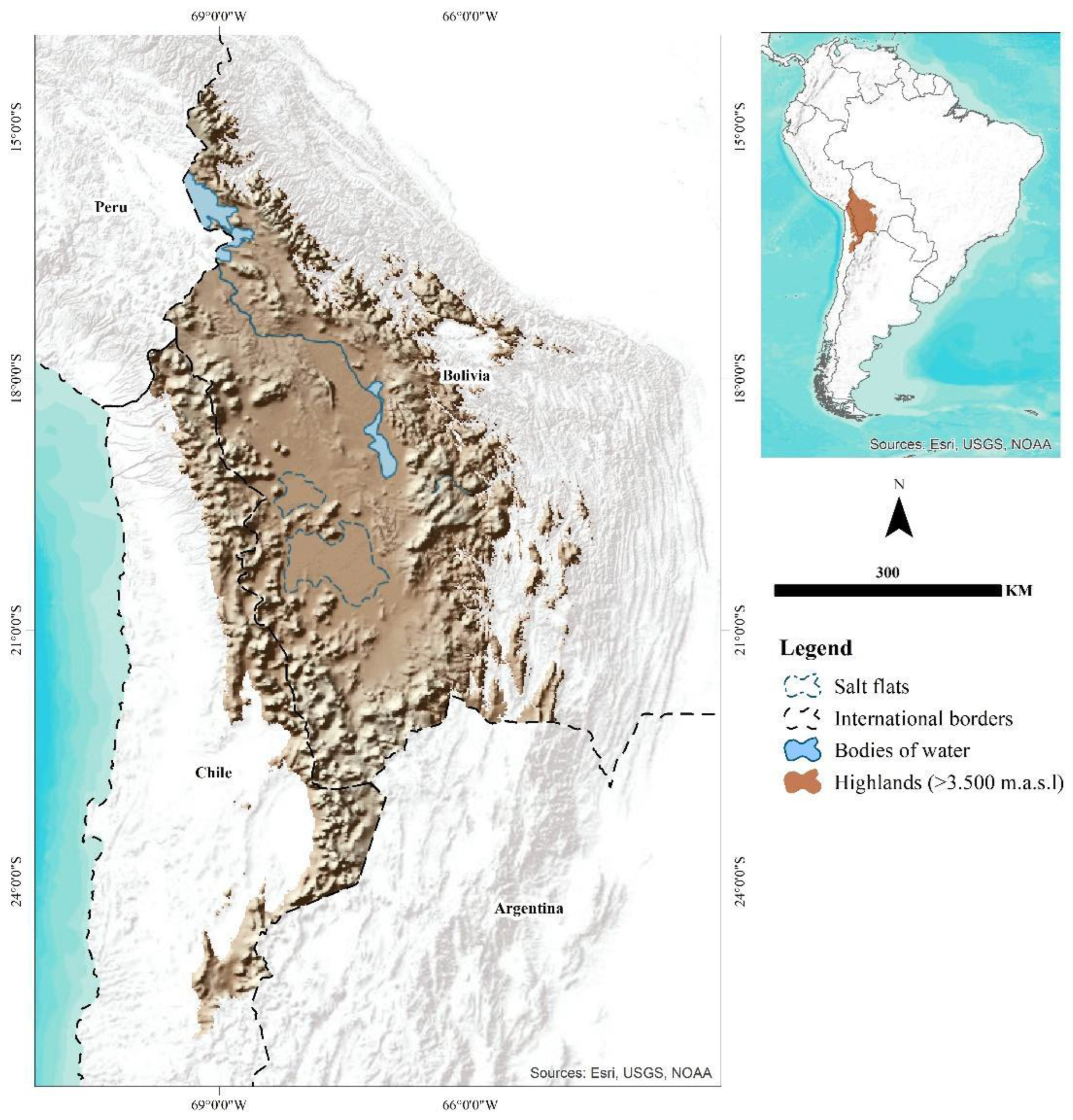
Beyond the factors traditionally studied as drivers of depopulation, the representations and imaginaries of the geography of the south-central Andean highlands (
Figure 1) have also played a crucial role. It is essential to recognize that the term “unpopulated” is not a static category nor a natural condition; rather, it is a relational phenomenon historically contextualized and perpetuated through images, representations, and discourses [
16]. These elements, in turn, materialize in the creation of the notion of abandonment, imbuing meaning in both individual and collective perspectives and becoming deeply ingrained, legitimized, and perpetuated within the geographical characteristics of specific places.
The portrayal of the highlands as a harsh and desolate desert [
17], akin to terra nullius [
18], has had a lasting impact. These perceptions have played a crucial role in facilitating their conquest, consequently perpetuating colonial dynamics and reinforcing capital through state intervention.
The term “unpopulated” has historically been employed in Chile to characterize the highlands, emphasizing both the demographic and physiographic aspects of the desert landscape. In fact, since the time of the first Constitution of Chile (1833), the northern border was referred to as the “unpopulated area of Atacama” (despoblado de Atacama) when defining national boundaries (Article 3), implying a perceived condition of emptiness. Furthermore, the “unpopulated” highland area coincides with what is known as the “cordillera”, referring to a series of mountains found in that region [
19].
Despite these perceptions, the highlands hold great strategic importance from both biophysical and climate change perspectives [
20]. This region functions much like a “water tower”, playing a crucial role in conserving semi-arid mountain ecosystems and the hyperarid zone located next to the Pacific Ocean [
21,
22]. This region maintains water availability for biodiversity, influences local and global climate patterns, and satisfies human and industrial water consumption needs. Essentially, it serves as a reservoir for water resources, exerting far-reaching effects on ecological and climatic processes.
Nevertheless, the trans-local nature of Aymara communities in the foothills and highlands of Chile’s northern regions [
23], combined with the concentration of the population in the main coastal cities such as Antofagasta, Iquique, and Arica, creates a dynamic in which Andean towns experience sporadic fluctuations in population during communal activities (primarily religious festivities and carnivals) [
24]. This phenomenon is critical for understanding the construction of the Andean geographical space from the concept of emptiness and for recognizing the emergence of power asymmetries.
While various researchers have explored representations of Chile’s Andes Mountains [
25,
26,
27], their primary focus has typically centered on the country’s central and southern regions. The northern zone, on the other hand, has garnered considerable attention from geocultural, anthropological, archaeological, historiographical, and international relations perspectives [
28,
29], as well as through the lenses of geohistorical [
30] and socioenvironmental studies [
31,
32].
However, the Arica and Parinacota Region—Chile’s northernmost area—has been overlooked by most researchers, particularly those that delve into geographical imaginaries. Hence, the current study aimed to fill this gap, enabling us to delve into notions of emptiness, depopulation, periphery, terra nullius, and desolated deserts within the context of the south-central Andes, with the Arica and Parinacota Region serving as a representative spatial unit.
The primary goal of this article was to conduct a critical examination of the prevailing portrayals of the south-central Andean highlands of Chile, often depicted as a peripheral and uninhabited desert region. Employing a geohistorical perspective that embraces geographical imaginaries, our study sought to address the following inquiries: what imaginaries, representations, narratives, or discourses concerning the notion of emptiness are prevalent in the context of the south-central Andean highlands? Furthermore, how do the narratives about this region relate to the ongoing depopulation of the Arica highlands? Our research sought to elucidate the complex connection between historical concepts, perspectives, and the socio-ecological changes occurring in mountainous regions. This study encourages us to envision the highlands as a lively and indispensable element of both cultural and ecological heritage, emphasizing their crucial role in addressing environmental issues.
Here, we employed a multifaceted methodology (comprising a review of secondary sources, analysis of cultural artifacts, examination of narratives from digital search engines, reference cartography, and surface area calculations) to investigate representations of the south-central Andean highlands and their connection to depopulation.
The article progresses through six sections. Following this introduction,
Section 2 details our research methodology. We then transition to
Section 3, where we develop the concept of imaginaries as an analytical tool for interrogating the production of space in Chile’s highlands. This foundational analysis lays the groundwork for
Section 4, where we delve into the representation of the mountains and the Atacama Desert. In
Section 5, the Discussion challenges conventional views that present these territories as empty, peripheral, enigmatic, and desolate, portraying the highlands as terra nullius open to appropriation. In
Section 6, Conclusions call to disrupt these misleading representations of the highlands and reimagine them as vibrant and indispensable facets of our cultural and ecological inheritance.
2. Materials and Methods
This research adopted a qualitative approach, employing a case study methodology to explore the imagery and perceptions associated with the south-central Andean highlands. To gain insights into this subject, we conducted a comprehensive review of secondary data sources, including historical and contemporary newspapers, cultural artifacts, and narratives found in major digital search engines such as Google, Yahoo, and Bing. Our investigation encompassed the period from the early 20th century—when Chilean sovereignty over the study area began—to the present day. We also grappled with the intricate relationship between the mountains and the Atacama Desert, which often appeared intertwined and confused in various depictions. Additionally, we created reference cartography and performed surface area calculations to facilitate meaningful comparisons.
The data collected underwent a process of organization and analysis. Initially, we prepared hermeneutic units to ensure a comprehensive understanding of the materials. Subsequently, we performed open coding and coding by list to categorize the data. This allowed us to identify emerging categories and patterns within the information. To consolidate our findings, we integrated and triangulated the content from various data sources. This approach enabled us to identify key ideas and generate descriptive syntheses of the diverse imaginaries, representations, narratives, and discourses related to the concept of emptiness in the south-central Andean highlands.
To present our results, we selected two specific media outlets (Pacífico Magazine and the Concordia newspaper) as illustrative examples because of their relevance and pertinence. Given the limited presence of a regional press in the study area, these two sources were chosen. Moreover, they represent distinct viewpoints, with Concordia being a locally circulated popular newspaper and Pacífico Magazine having a broader readership primarily comprising affluent and male audiences. This selection enabled us to compare and contrast varying perspectives and served as a valuable lens through which to examine our research objectives.
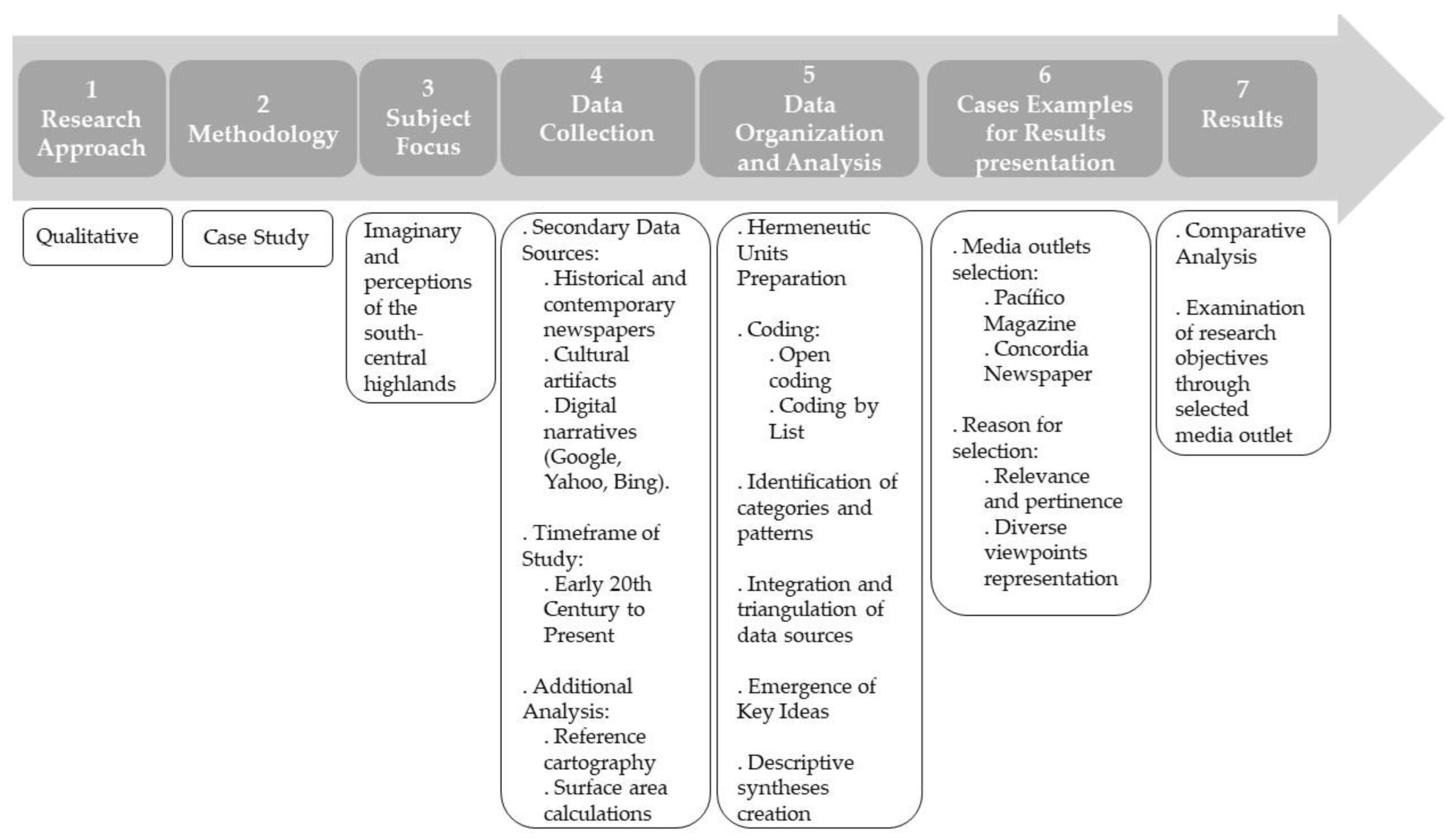
The methodological procedure described is illustrated in
Figure 2.
3. Production of Space through Imaginaries
Here, we used the concept of “imaginaries” as an analytical tool to delve into the social construction of Chile’s highlands [
33]. The utilization of geographical imaginaries to decipher spatial phenomena has been a noteworthy focus in Euro and Anglo-American geography since the mid-20th century [
34,
35], as highlighted by Yi-Fu Tuan in 1977 [
36]. By contrast, Latin American literature has only begun to extensively explore these perspectives since the 1990s [
37].
Within this context, the concept of geographical imaginaries encompasses the various ways in which spaces are represented and perceived, coexisting alongside spatial depictions and the portrayal of geography [
38]. In cultural studies, “representation” encompasses the essential elements of a culture, serving as symbolic patterns that guide the organization of discourses and societal activities. Representation constitutes the framework through which individuals perceive and interpret the world [
39]. This approach goes beyond the mere representation of space; it also facilitates an exploration of the “production of space” [
40]. By examining how these geographical imaginaries contribute to the construction and understanding of spatial reality, we gain a deeper understanding of the intricate dynamics underlying the formation and transformation of physical and conceptual spaces.
From this perspective, space transcends being a mere cognitive structure for the physical and visible world; it becomes a complex representation infused with valuations. As articulated by Bailly, individuals craft their own realities by integrating the structural, functional, and symbolic dimensions [
38]. The structural dimension pertains to how individuals interact with environmental structures in their spatial practices. The functional dimension encompasses considerations of space, time, access, and economic potential within a place. Meanwhile, the symbolic aspect, often situated within the geography of representations, unveils the manifold spatial connotations and intricate webs of connections linking individuals, society, and place [
38]. These three facets, with a particular emphasis on the symbolic, play pivotal roles in the construction of reality and serve as the foundational matrices of meaning, often referred to as “imaginaries” that shape representations [
41].
In recent years, notable theoretical advancements in the formation of geographical imaginaries have been instrumental in elucidating social and spatial interactions within specific contexts [
42]. Numerous scholars have intertwined the social imaginary with the spatial realm to explore both geographical imaginations and imaginary geographies [
43,
44]. Examining geographical imaginaries is useful because of the fundamental nature of the mental images individuals construct as they engage with the world. These mental constructs are inherently intertwined with both social and spatial dimensions [
45].
To imagine is the process of creating mental images or conceptualizing what is not yet perceptible to the senses [
46]. In this context, the imaginary depends on the imagination of a specific social subject [
47,
48]. Therefore, the concept of imagination delves into an intrinsic aspect of the social world, which, although immaterial in nature, bears material consequences. Consequently, the imaginary is intertwined with both social and spatial dimensions [
45]
The concept of the geographical imaginary refers to the metaphorical ways through which individuals conceptualize and render space visible [
49]; it encompasses perceptions of space that arise from various sources, including images, texts, maps, symbols, and narratives [
46]. These images are perpetuated through numerous references drawn from sources such as the media, cinema [
50], literature [
51], visual arts [
52], and music [
53]. In this article, we employ the term “geographical imaginary” rather than “geographical imagination” as it denotes a contextual and socially grounded approach [
54]. Beyond being comprehended solely through the experiences and perceptions of individuals, geographical imaginaries are viewed as instruments for the exercise of power, appropriation, and control [
33]. They serve as valuable tools for governmental and business entities within a commercial context, enabling the creation of representations, symbols, and identities to delve into people’s motivations and, in turn, assert control.
Following Gramsci’s notion of hegemony, Angenot posits that by conducting a comprehensive analysis of the social discourse, it becomes possible to discern the interdiscursive dominances, the ways of knowing, and signifying what is known, which are typical of a society and which regulate and transcend the division of social discourses [
55]. Discursive hegemony thus emerges as the result of a constellation of forces that impose a framework for what can be articulated within a given society, profoundly influenced by the ruling class.
If we consider that images serve as a means of addressing human relationships with the environment, effectively acting as a condensed representation of the connections between individuals and space, then the narratives that mediate and convey these images become vehicles for shared individual and collective meanings. Consequently, this process internalizes spatial forms.
In this manner, images and words collectively shape the thoughts that configure reality and, as a result, are inseparable [
45] from the formation of representations, whether they pertain to the tangible geography of lived experiences or extend into the realms beyond human reach [
56].
According to Hiernaux and Lindón, the fabric of everyday life vividly illustrates that the utilization and reliance on visual representations have assumed a central role as intermediaries between the world and human activities [
45]. Consequently, the manipulation of visual imagery becomes a nuanced strategy entwined with authority and influence over individuals.
Engaging with these discursive images, especially in geography, challenges dominant narratives and prompts critical examination of how representations shape our understanding, resisting established power structures.
3.1. Colonial Geographical Imaginaries in the Construction of the Nation
Representations constitute an object of study for cultural and subaltern studies [
57], contributing to the critical disciplinary arrangement of critiques of hegemonic discourses that, in turn, articulate representational practice [
58,
59].
Representations play a central role in the cultural fabric and, consequently, in the perpetuation of power [
60]. At its most basic level, representation involves the reconstruction of reality through the use of signs, whether they are iconic, linguistic, or symbolic. However, it is important to recognize that these signs do not exist in a vacuum but must be carefully contextualized within their historical framework to fully appreciate their meaning and relevance.
This historical contextualization entails consideration of the power relations that govern what can be expressed or perceived at any given moment; its purpose is to maintain an established social order, allocate specific social roles and positions, and construct shared concepts that are often accepted without critical questioning. Nevertheless, it is essential to unravel these concepts to expose their inherently ideological nature [
61,
62,
63]. This critical analysis is crucial for understanding how representations contribute to shaping social reality and how they influence the dynamics of power within a society.
The recurrence of certain images, symbols, or metaphors plays a role in this discourse that can hardly be questioned, and this vocabulary of metaphors becomes validated despite its lack of precision because it circulates in the sphere of the imaginary to influence how people view the elements or phenomena that it is intended to represent [
64]. Thus, examples of these phenomena can be noticed in the scientific–political expeditions of the Age of Enlightenment and European colonial expansion, in which, for example:
“[…] The territories that were especially inhospitable for travelers were conceptualized as deserts, whether they were moors, steppes, or waterless crossings, or whether they were jungles or impenetrable swamps”.
A further example is the link between cartography and nationalism in Latin America [
65]. Maps were used as a tool for social cohesion and contributed to identity formation through the creation of geographical imaginaries that transcended individual interpretations to unify an official reading of a territory.
During the process of national expansion, a discursive legitimation was produced, which consisted of “the generation of a symbolic emptiness that allows for the conception of these territories from the perspective of their necessary appropriation” [
66] (p. 150). In this discourse, “the Western European cultural paradigm assigned the category of desert not to uninhabited or barren territories but to those not appropriated or cultivated according to capitalist patterns” [
16] (p. 140).
For Tomé, “The deserts constitute the last ‘wild’ spaces on Earth that remain unexplored and yet to be conquered by civilization” [
66] (p. 148). This is because deserts are spaces without vegetation, fauna, or water and, above all, without people.
The identification with and assignment of desert characteristics to a given territory inevitably invalidates and conceals its inhabitants. In the discourses that legitimized conquest, for example, inhabitants were frequently perceived as nonexistent or as savages who could be eradicated [
66].
Furthermore, in the configuration of nation-states, territories expanded toward unknown places where Indigenous communities lived, and military campaigns to conquer them were sanctioned “in the name of progress and civilisation, considered the only and indisputable moral and national values” [
67].
Ascribing desert characteristics to a territory is not a benign act; rather, it carries serious consequences. As one source notes, the seemingly impartial and objective labeling of a region as a desert evokes a sense of “horror and emptiness”, which, in turn, necessitates the immediate infusion of “civilization” [
66] (p. 150). By framing a territory as desolate and inhospitable, it lays the groundwork for subsequent intervention and development. Margarita Serje created a collection of images and discourses that underscore the fusion of the modern world with various groups, cultures, and societies portrayed as subalterns, positioning them on the fringes of progress and opening up new frontiers for expansion [
68].
By the final decades of the 19th century, the concept of Western modernity in its Eurocentric capitalist and bourgeoisie form had gained hegemonic status among the Latin American ruling elite. Positioned advantageously, they implemented a “scientific–technical” strategy aimed at enabling economies that exported raw materials to integrate into the global capitalist system. This involved enhancing productive structures’ efficiency without altering the social relations of production that contradicted modernity [
69].
The onset of modernity in Latin America was a project initiated by local oligarchies to solidify their political and economic dominance. However, for most of the subordinate population, mainly the Indigenous and popular sectors, it entailed uprooting their traditional ways of life and the violent imposition of new lifestyles.
The experience of capitalism made market relations the universal mode of interaction between individual and collective actors [
69]. This shift toward market-based relations reshaped not only the economic landscape but also the societal dynamics in Latin America.
In this context, a spatial dimension emerged, closely linked to the consolidation of national projects and their imperative expansion into peripheral or remote territories where sovereignty remained undefined. This spatiality envisioned “uninhabited” regions and untamed landscapes where, much like an empty canvas, the dimensions of their expanse, their boundaries, and even their potential or preordained paths of progress, were etched and recorded through their toponymy [
27].
This spatiality imagines “empty” spaces and wild territories in which, as on a blank sheet, the measures of their extension, limits, and even possible futures, or their predestined progress, are inscribed and written out of their toponomy [
27].
3.2. Imaginaries of the Periphery in the South-Central Andes
Spatial references for terms such as unpopulated, empty, hostile lands, border, and periphery point to a condition of terra nullius, which is an empty territory without an owner and, therefore, available for appropriation. In this way, conceptual foundations are laid that allow primitive accumulation through actions typical of the coloniality of power [
70]. This power seeks to incorporate territories into processes of capitalist accumulation under the veil of civilization, development, and progress. The inhabitants of these territories are thus made invisible or presented as constraining the modernization project and must be civilized [
71,
72].
The peripheral condition of the south-central Andes is therefore attributable to historical and social processes that are legacies of the consolidation of the nation-state in the 19th century [
69]. The peripheries constitute spaces that express the forms of appropriation and imagination to which territories and subjects have been exposed by the nation, as “[…] The very production of ‘peripheries’, that is, what is excluded, is one of its necessary conditions. The consolidation of the identity of the center implies the reification of its margins”. [
68] (p. 20).
A substantial portion of what is now northern Chile was legally incorporated into the state in 1929 through a treaty between Peru and Chile as part of the negotiations following the War of the Pacific. However, the city of Arica (
Figure 1) was under Chilean occupation and political administration during the war. During this event, the process of Chileanization began, consequently leading to the imposition of a single national identity [
73]. This involved an ethnic clean-up that included Bolivians and the Indigenous population in particular, with the purpose of imposing a single Chilean identity or, failing that, of forcing their expulsion from the new national borders.
The process of Chileanization was accompanied by the construction of images of the recently annexed territory, and the geography of the Andes Mountains came to embody a space of representational disputes. The nation-state used these images of territorial representation to ideologically reproduce its own image in articulation with the imaginary of a single national identity [
25,
74].
In this context, images of the border regions play a leading role in the processes of state territorialization. They impose internal territorial delimitations to demarcate the country in line with an ideal type of national identity, making the border “other” or different from other territories and their inhabitants. The border thus “evokes and ratifies the existence of others, who in essence occupy a territory of a different nation and are therefore different” [
72] (p. 141). The idea of borders is consistent with Said’s notion of imagined geographies [
59]. It involves the widespread practice of mentally distinguishing between a familiar “our” space and an unfamiliar “their” space, which can often be arbitrary. This means that the concept of an imagined geography, which serves to differentiate between “our territory” and that of “the barbarians”, does not require acknowledgment or recognition from the barbarians themselves.
The lack of formal documentation confirming Indigenous land ownership has reinforced the concept of terra nullius. This situation has given rise to dynamics that disregard their land rights. Particularly significant was the 1911 decree by the Chilean government that expropriated communal lands, resulting in the loss of communal control over the territory. Since then, the Aymara people have devised various strategies to obtain formal recognition of their land ownership, which they had freely inhabited for countless generations. While some lands in the region have been registered as private property belonging to Aymara families and others have been registered under collective property arrangements, the persistent notion that the highlands constitute an empty or uninhabited territory has led to the dispossession of natural resources and the imposition of laws that frequently disregard the rights of Indigenous communities [
75].
Consequently, both geographic imaginaries and their representations are developed within concrete cultural practices that involve processes of production, circulation, and consumption, through which these practices are then reproduced. In border contexts, they are often accepted uncritically, which reinforces negative stereotypes regarding the “other”, their culture, and their territory.
4. Representations of Mountains and Deserts in Northern Chile
In this section, we employ a review of periodicals and secondary sources to delve into the evolution of collective perceptions regarding the region encompassing the Atacama Desert (an area annexed by Chile) and the Andes Mountains. Our investigation sheds light on how this territory has been conceptualized as an unfamiliar and enigmatic expanse open to appropriation. Drawing from these data, we uncover inherent contradictions and paradoxes within the narratives surrounding both the desert and the mountains. These contradictions contribute to the formulation of an “otherness” deeply rooted in imaginaries that are shaped by the portrayal of these distinct geographies. To untangle and examine these contradictions, we proceed to trace the narratives and depictions of the highlands during the early and mid-20th centuries, as they are presented in the various sources we have scrutinized, following a chronological sequence.
4.1. Pacífico Magazine: The Mining Wealth of Bolivia (1913)
Pacífico Magazine, published by the Zig-Zag publishing house, was part of the periodical landscape from 1913 to 1921. As a symbol of modern Chilean journalism, it catered primarily to a readership characterized by its whiteness, upper-class status, education, cosmopolitan outlook, and considerable purchasing power [
76]. This magazine held a prominent place as a platform for discussion and dissemination of ideas among the early generations of republican intellectuals, who are now recognized as pioneers of national culture.
Within the pages of its 1913 edition, an article titled “Riqueza minera de Bolivia” (The mining wealth of Bolivia) made reference to a town named Caquena (
Figure 1). The magazine’s cover featured a captivating photograph of the Caquena Pampa in the Bolivian highlands, cleverly emphasizing the shared physical and natural features on both sides of the imposing Andean massif. The article took a deep dive into the profitability of silver and gold production from the perspective of European investors. Bolivia was designated as one of three globally significant locations brimming with abundant mineral resources. The narrative not only outlined points of interest for mining but also delved into the extraction of other valuable minerals including tin, bismuth, and zinc. However, it is in a section titled “economic conditions of the mining industry in Bolivia” that we find a portrayal of the highlands that warrants closer examination:
Undoubtedly, when considering a country’s natural mineral wealth, the conditions that have the greatest influence on the success of exploitation are its climate and its transportation routes.
There are climates that the white race, dominant in the world and in its businesses, rejects or only approaches with extraordinary compensations, such as tropical climates or those near the poles. The climate of the Bolivian highlands does not involve these inconveniences of excessive heat or cold […].
The climate of the high plateau is like a continuous winter in temperate regions, with some strong cold in the early mornings during the months that correspond to our winter, easily bearable with warm clothing. Then, shortly thereafter, the splendid sun arrives to make us forget our discomfort, uplifting both our physical and moral spirits.
People born in the cold northern European countries have nothing to find strange in Bolivia and easily adapt to the high-altitude climate. The Scots live there comfortably, reminiscent of the highlands of their own country
Furthermore, sources and water currents, nourished by the rainy season, which corresponds to summer, ensure an abundance of the primary element for both animal and industrial life is readily available everywhere”.
In this passage, the highlands emerge as a land ripe for development, remarkably adaptable for Europeans and their business ventures. Its geography and climate, often likened to the temperate zones of northern Europe, pose no substantial hindrance to daily life. Foreigners might even find themselves feeling quite at home amidst this familiar landscape.
4.2. Concordia Newspaper: Caquena Is also Chile! (1960)
Half a century after the publication of Pacífico Magazine’s article, the Chilean newspaper Concordia (a locally influential periodical that held sway in local circles) emerged during the 1960s and featured its own captivating piece centered on Caquena, titled “¡Caquena también es Chile!” (Caquena is also Chile!). In this article, the author made the following assertion, shedding light on the remote town and its connection to Chile:
There are localities so far from densely populated centers in our territory that often people hold a contrary opinion about them. A tangible demonstration of the Chilean spirit that prevails within the Arica department was the inauguration ceremony of the new school building in the Caquena locality, located more than 200 km from Arica and just six kilometers from the border that separates Chile from Bolivia […].
A bass drum [bombo] and four panpipes [zampoñas] that sound and resonate in the inhospitable places of the mountain range mark the starting point of the annual religious celebration in the remote little village of Caquena […].
An elderly woman with a weather-beaten face from the sun and cold of the mountain range carries a pot to burn incense, enhancing the tribute to the religious figure.
The attire of the men, women, and children in this hidden and forgotten village in the mountains, just 6 km away from a neighboring country, is vibrant. Garments made in Chile blend with those manufactured in the Bolivian highlands.
This compelling portrayal not only illustrates the unique character of Caquena but also underscores its affiliation with Chile. The article emphasizes the enduring Chilean spirit that thrives in the remote corners of the Arica Department.
The comparison between the two articles highlights the striking differences in their portrayals and perspectives of the same geographical space. These differences influence the point of view of the readers, their interests, and the predominant narratives of their respective eras.
In Pacífico Magazine, the highlands are depicted as an accessible and promising territory, primarily due to their climate similarity to northern Europe and the abundance of valuable mineral and water resources. This representation aligns with the prevailing racial discourse of Western supremacy that permeated the media during that era. The portrayal underscores the region’s potential for European investors and settlers, painting a picture of a profitable environment.
Conversely, the Concordia article offers a different lens through which Caquena is viewed. Despite its intention to make the town relatable to urban readers through the description of a school inauguration, the article portrays Caquena as remote and unfamiliar. It uses phrases like “the inhospitable landscape of the mountain range” and describes an old woman with a face “tanned by the sun and the cold”, conjuring an image of a challenging living environment. This portrayal emphasizes the geographical and climatic challenges of the region, suggesting a rugged and unforgiving terrain.
The character of the Indigenous inhabitants is subtly implied through their described “impenetrable attitude”, reinforcing the stereotype of these territories and their native populations as potential obstacles to development. Caquena is presented as closer in affinity to Bolivia than to Chile, primarily due to its mountainous condition, which situates it on the periphery or outside of the national domain. Caquena is portrayed as “other” territory, distinct and distant, evoking an image of backwardness that must be overcome for “civility” to take root. While the inauguration of the school is celebrated as a step toward progress, Caquena is simultaneously depicted as a place rich in tradition and folklore from a Chilean perspective, setting it apart from “our border city” of Arica.
These differing perspectives serve as valuable insights into the evolving narratives and perceptions of this unique region over time, shedding light on how geography, climate, and cultural factors contributed to varying depictions of the same geographical space.
4.3. The Inhospitable and Unpopulated Atacama Desert
Historical sources shed light on how the Atacama Desert gained notoriety as the world’s most arid place in the early 20th century, drawing the interest of various scientists and explorers, including Rodulfo Amando Philippi, San Román, Lorenzo Sundt, Alejandro Chadwick, Santiago Muñoz, and Abelardo Pizarro. This fame can be attributed, at least in part, to its geographical location.
The Atacama Desert and the Tamarugal Pampa experience a condition of hyperaridity, lacking in rain and vegetation, usually characterized by their inhospitable nature and “[…] the difficulty of its connections due to the absence of nearby towns, except for the concentrations in the cantons of nitrate offices until the crisis of the 1930s” [
78] (p. 220).
For González [
78], the Atacama Desert was presented in opposition to the humid central and southern areas of Chile. The natural and geographical characteristics and attributes of the Atacama Desert were not emphasized, although a large percentage of the country’s geological and mineral wealth was located in the territory, as evidenced by the rise of the saltpeter industry between 1880 and 1930 and the subsequent boom in copper mining (see also [
30]). González highlights the stereotyped image of the area that was presented in popular texts, such as Baedeker’s Travel Guide for the Republic of Chile (1910) or Twentieth Century Impressions of Chile (1915). These publications both reveal and hide certain features of the north. The first surveyed the city of Iquique and its coastline, and the second considered that, in northern Chile, only the saltpeter-producing cities of Antofagasta and Iquique were habitable for capitalist development because of their railway and port infrastructure.
If the coastal cities of Antofagasta and Iquique were the only “habitable” ones, it follows that the rest of the northern territory had a wild landscape and a harsh climate, among other stereotypes—characteristics that were extended to its inhabitants. The territory was, in short, an unfavorable landscape for development as it was located outside of the latitudes of what was considered “Chilean” and constituted a space that was “inhospitable, established as a synonym for the desert” [
78] (p. 222).
The conceptualization of the periphery, whether it be desert or mountain, often overlooks the actual ecosystem of the territory, leading to the prevalence of representations, discourses, and arguments of emptiness. Consequently, political and governmental actions aimed at appropriating these regions find justification through the establishment of a geographical imaginary that persists to this day.
One emblematic case is the diversion of the waters of the Lauca River in the 1960s [
79]. These waters continue to be redirected to support semi-industrial agriculture development in Arica. Furthermore, the imposition of legislation such as the Water Code and the Mining Code during the military dictatorship in the 1980s exacerbated this situation. While the former has allowed mining companies to assert extraction rights in territories historically claimed by Indigenous communities [
80], the latter has enabled industries to extract water from the highlands for mining facilities [
81]. More recently, the lithium boom has further worsened this situation by initiating and designing projects to extract lithium brines from salt flats located within Indigenous lands [
82]. Furthermore, environmental conservation policies through protected areas have contributed to this process [
83] by treating the region as virgin land and perpetuating the myth of pristine wilderness [
84], while ignoring how many of the highlands, instead of being wild, have also been shaped through practices rooted in traditional ecological knowledge [
85]. However, even the environmental value of the highlands cannot withstand the constant threat of extractive industries. To illustrate this, in 2010, then-President Piñera announced the decommissioning of 31,500 hectares of Lauca National Park to allow for private mining in the area, with the aim of producing 240,000 t of fine copper per year. Subsequently, in 2014, the government attempted to designate 5% of Lauca National Park’s highland area in the Arica and Parinacota Region for mining purposes [
86]. These examples demonstrate how the erroneous perception of emptiness and underdevelopment continues to shape policies and actions affecting the region, leading to substantial consequences for both the environment and Indigenous communities.
4.4. Extrapolation of the Desert and the Unpopulated area of Atacama toward the Andes
Representations of the desert and mountains in northern Chile have contributed to the creation and perpetuation of a seamless connection between these two distinct spaces. The desert’s portrayal has extended and amplified its spatial distribution and geographical characteristics, projecting a uniformity of arid conditions across a larger area than it actually occupies.
A simple search for the “Atacama Desert” on major digital search engines (Google, Yahoo, and Bing) yields representations similar to the one depicted in
Figure 3. In this representation, the desert appears to possess consistent features from the coastal region to the Chilean and Bolivian Andes Mountains. This generalized depiction has become prevalent, especially in Chile’s northern regions that lack urban centers, and fails to recognize the topographic variations within the Andean landscape.
Northern Chile has evolved into an imagined space characterized by limited resources and challenging living conditions, primarily due to restricted access to water. This perception transforms the region into what appears to be an uninhabited expanse, giving rise to a geographical imagination closely tied to the notion of Atacama as hyperarid and desolated. For instance, explorers have labeled this area as the “unpopulated area of Atacama”, [
87,
88] likening it to a “lunar landscape” [
89]. More recently, National Geographic described Atacama as “sterile” [
90] and NASA called it “the most Mars-like environment on Earth” [
91]. Furthermore, the Chilean government and tour agencies actively promote tourism in the region, using metaphorical names for places such as “Moon Valley”, “Death Valley”, and “Mars Valley” [
92].
The notion of the desert to which northern Chile has been subjected (
Figure 3) represents an assumption that has no foundations in any geography or ecosystem that would classify it as such. This is seen in studies such as Sarricolea’s [
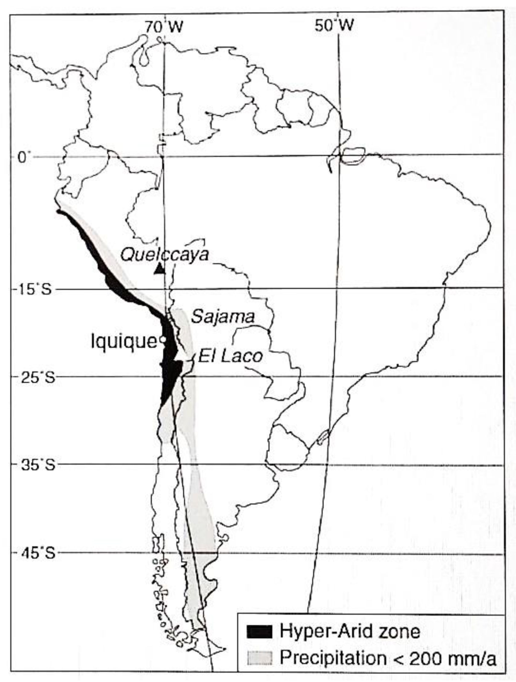
93], where the highlands are classified as a polar zone with a tundra climate and dry winter, or Houston, Hartley, and Clarke’s [
21] (
Figure 4), where the region is described as semiarid.
Figure 3.
Representation of the Atacama Desert in popular search engines. Source: Google Images [
94].
Figure 3.
Representation of the Atacama Desert in popular search engines. Source: Google Images [
94].
Hence, representations of northern Chile respond to common understandings and ideological perceptions from a space in which certain characteristics are validated. The notion of desert, in general, is therefore conceived as a sign or watchword.
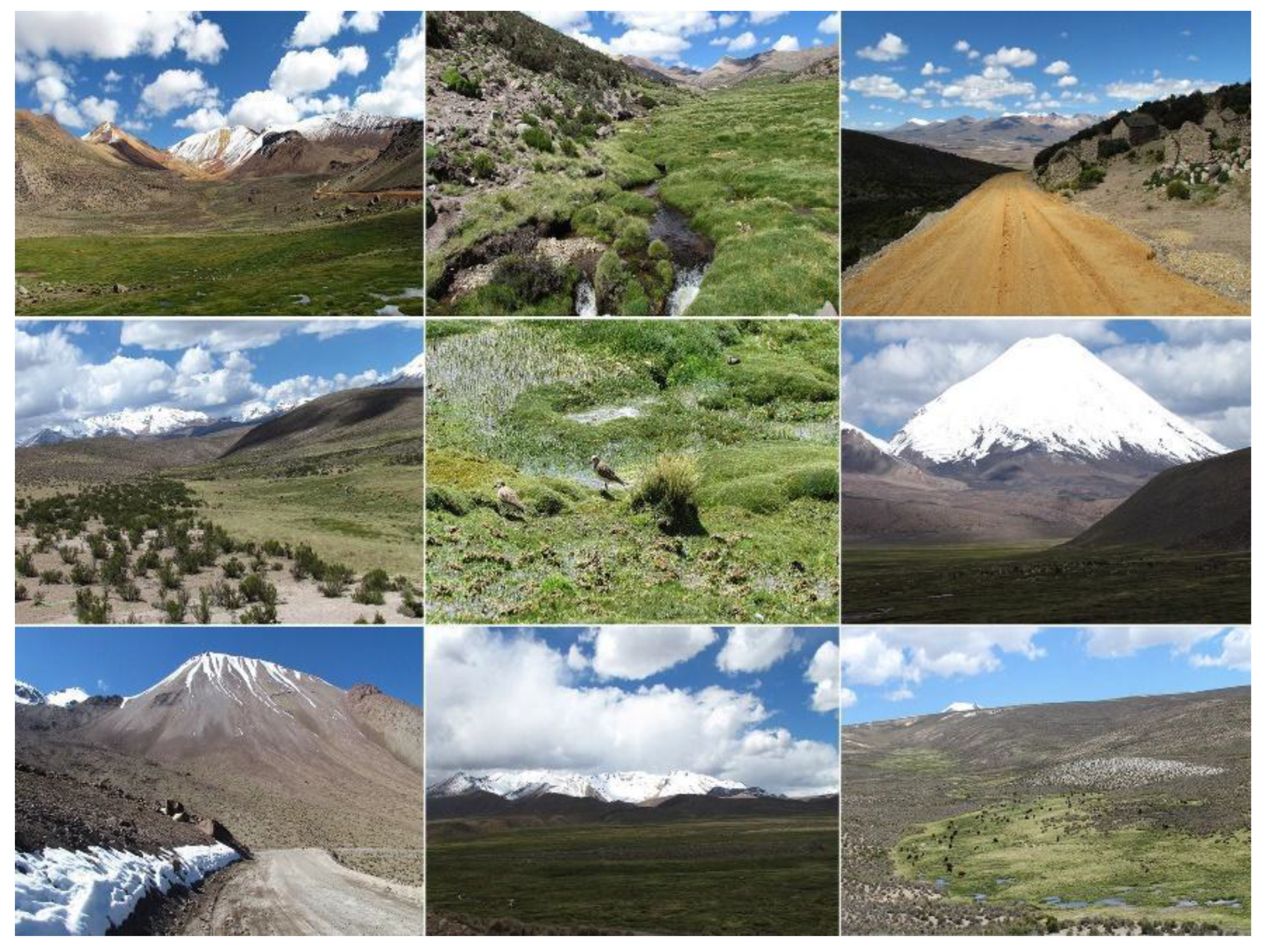
Figure 5 presents a set of photographs taken during light snowfalls between August and September 2018 in the Chilean-Bolivian highlands. These photographs demonstrate that the desert is not the same as the mountains, but quite the opposite. In essence, the representations of northern Chile align with prevailing common understandings, and these ideological perceptions create a space in which specific characteristics are endorsed. The concept of a desert, in general, is thus conceived as a sign or catchphrase.
4.5. The Highland Country?
The cultural elements under examination reveal a profound connection between the highlands of northern Chile and the Bolivian territory. These cultural elements highlight striking similarities in physical attributes and natural characteristics, as well as in the characteristics of their respective populations. Notably, these shared characteristics do not conform to national borders but rather serve as mechanisms that emphasize their interconnectedness while distinguishing them from other regions.
In the contemporary Chilean press [
95,
96], there is a tendency to emphasize the uniqueness of the Bolivian highlands by frequently referring to Bolivia as “the highland country”. This casual description subtly suggests a geographical distinction, making it seem as if Bolivia is the sole nation with high-altitude areas, neglecting the fact that similar high-altitude regions also exist in Chile. However, this portrayal oversimplifies the intricate geography of the Andes, as it fails to acknowledge that not all of Bolivia is located on the highland plateau. However, how much larger is the highland area in Bolivia compared to that in Chile? To address this question, we conducted an analysis of highland areas (situated at 3500 masl or higher) in both countries.
For Chile, our calculations encompassed the entire national territory. To facilitate a meaningful comparison, we only considered the Andes in the Norte Grande region. In the case of Bolivia, we considered its national territory to determine the proportion classified as highlands.
Table 1 presents the outcomes of these calculations. Of the total national land area, 11.6% consists of terrain exceeding 3500 masl in Chile, whereas in Bolivia, this figure stands at 19.5%. Therefore, Bolivia has a mere 7.9% more highland area than Chile. The remaining portion of Bolivia’s territory comprises the tropical and subtropical Yungas Forest and lower-altitude valleys extending toward the Amazon (see
Figure 6).
5. Discussion
In this article, we ventured through the intricate tapestry of imaginaries and representations that have come to define the northern Chilean highlands in the Atacama Region. These lands are inscribed with the marks of historical processes, bound up with notions of emptiness, periphery, terra nullius, and desolation.
Our geohistorical analysis has enabled us to probe into the historical context and the contemporary significance of these imaginaries. We dissected the notion of “unpopulated” and revealed its nature as a dynamic, historically situated construct that has been perpetuated through images, representations, and discourses. This constructed sense of abandonment has seeped into both individual and collective consciousness, becoming naturalized, legitimized, and sustained within the specific geographical characteristics of particular places.
We scrutinized how the depiction of the highlands as an arid and inhospitable desert has been pivotal not only for facilitating conquest but also for perpetuating colonial dynamics and bolstering capital through state intervention. The desert has become embodied in the mountains as an extension of a void [
66], which has contributed to the depopulation phenomena in the Chilean highlands of the Arica and Parinacota Region. These perceptions have significantly influenced the identity and occupation of the region from the inception of the first Chilean Constitution in 1833 to the present.
The spatial object has emerged as a tool to maintain exclusion and alterity [
44,
58,
68] through discursive strategies that designate spaces with arbitrary characteristics, with the ulterior motive of leveraging this constructed image to argue for state intervention. The “highland country” has become a mechanism for exclusion and the production of hostile subjectivities, generating peripheries and a sense of premodernity, and framing the Bolivian as an emblematic “other”.
Beneath these persistent misconceptions lies a region of vast cultural and biogeophysical wealth. The highlands are embroiled in the complex challenge of depopulation, driven by a web of geopolitical, social, economic, and environmental factors. Representations and imaginaries of the geographical landscape have significantly influenced the destiny of the highlands. The depiction of emptiness and desolation has fueled the marginalization of this region and the continuation of colonial dynamics.
6. Conclusions
Our research brings to light the pressing issue of depopulation, exacerbated by representations that paint the highlands as a desolate wasteland. The mountains are portrayed as empty, fostering a narrative that justifies state intervention over a perceived peripheral space. The concentration of the population in the main cities of northern Chile serves as a representation of the modern space where people are expected to live, positioned in opposition to the highlands and facilitating their domination.
While the idea of desolation has indeed precipitated colonial interventions, it also generates geopolitical contradictions, especially in contested territories such as those disputed with Bolivia. The narrative of abandonment suggests a relinquishment of these contested spaces, an issue that has garnered recent attention in the press and governmental efforts.
The government’s initiatives, such as the Parinacota Plan [
97], aim to tackle the complexities of repopulation and development. This work continues to be explored in ongoing projects where we anticipate further development and engagement with these intricate dynamics.
This study is a clarion call to challenge and deconstruct the misleading representations of the highlands. We endeavored to illuminate the complex interplay between historical constructs, perceptions, and the socio-ecological dynamics of the highlands. It is an invitation to reimagine the highlands not as barren outposts but as vibrant and indispensable facets of our cultural and ecological inheritance, pivotal in confronting environmental challenges.


