Abstract
Urban parks, as major components of green infrastructure, have contributed to natural landscape preservation, ecosystem service provision, residents’ physical and mental health enhancement, and social cohesion intensification, under the emphasis on the need for sustainable urban development. However, urban parks have been insufficiently and inappropriately created in the process of the urban space expansion and population density increase, necessitating their equitable distribution and access. This study aimed to analyze the distribution characteristics of a total of 354 urban parks in Seoul, South Korea, utilizing the estimates of floating population derived from big data and the urban park catchment areas, in the context of the 15-minute city. Its 25 districts were classified into the following four types based on the relationship between the area and the population ratios for the 600 m and 900 m catchment areas: Type 1 parks were equitably distributed with well-matched supply and demand; Type 2 parks had an uneven distribution due to insufficient supply and excessive demand; Type 3 parks were inadequately distributed with both supply and demand below average; and Type 4 parks had a mismatch between sufficient supply and unfulfilled demand. This study suggested strategies to improve the spatial equity of urban parks for each type, including qualitative improvement, quantitative increase, redistribution, and accessibility optimization tactics.
1. Introduction
The need for sustainable urban development has been highlighted following major issues such as the increase in population and residential density, the exacerbation of urban shrinkage and spatial-social inequalities, the occurrence of urban heat islands and urban floods, and the rise in carbon emissions in cities. Considering that sustainable development aims to find and maintain a balance between economic development, environmental protection, and social well-being, green spaces in cities are important for manifesting such goals [1]. The way of securing, utilizing, and managing green spaces can ultimately contribute to the progress toward sustainable cities by enabling the securing of new stimuli for growth based on green economy, preserving biodiversity and responding to climate change, and improving the quality of life for urban residents. As public facilities and major components of green infrastructure, urban parks not only preserve natural landscapes and provide ecosystem services but also promote the physical and mental health of residents and strengthen social cohesion through exercise, leisure, recreation, and social activities [2,3,4,5,6,7,8,9,10].
However, as the issue of spatial imbalances in cities, which reflect unsustainable physical, social, and economic features, rises to further prominence, the need for equitable distribution and access to urban parks, which are representative of urban planning facilities, has grown [11]. Equity aims to distribute resources and services evenly among individuals as well as fairly and appropriately within society [12]. Social sustainability achieved as such ensures equal access to various benefits and opportunities, regardless of social categories such as income or class [13]. Equity in relation to urban parks refers to social or political consensus on the fairness or justness of their spatial distribution [8,9]. Urban parks may be deemed equitably accessible when available in accordance with the current spatial distribution and demands of the population using the service [4].
Along with urban space expansions and population density increases, the supply of parks in cities heretofore is known to have been insufficient and unevenly and improperly distributed [5,8,14]. It has been assessed in numerous cases that traditional park models have created unequal, underutilized, dangerous, and low-quality urban public spaces [3,15]. Related studies have revealed that vulnerable classes of low socioeconomic status, such as the elderly, the less-educated, immigrants, ethnic minorities, low-income classes, and households with living areas of less than 50 m2, experience inequality in terms of access to urban parks and green spaces as well as the quantity and quality thereof [5,7,9,16,17,18,19]. The urban planner Jane Jacobs critiqued that open space had been treated in an astonishingly uncritical way in canonical urban planning, questioning “Why are there so often no people where the parks are and no parks where the people are?” [20].
Meanwhile, the concept of the 15-minute city has recently garnered attention as a measure to realize sustainable and equitable urban development. The plan for this, which emerged in tandem with the contraction of living radii due to the COVID-19 pandemic and the activation of personal mobility, redefines human activity and quality of life, with a focus on proximity to the urban space. Its objective is to ensure equal access to facilities and services related to education, business, commerce, medicine, and culture for all people by creating a small living-zone in which urban infrastructure and functions are distributed in a balanced manner within a 15-minute radius [10]. Considering that one of the principles defined by Professor Carlos Moreno, who advocated for the 15-minute city, was providing sufficient green spaces for all citizens to enjoy clean air, the concept of this kind of city is aligned with the need for spatial equity of urban parks asserted by urban academia and civil society.
In Seoul, South Korea, the “10-minute Neighborhood Life-enhancing SOC Project”, which is similar to the concept of the 15-minute city, has been implemented since 2019, along with the related ordinances. The Seoul Metropolitan Government aimed to create tighter-knit life-oriented social infrastructure, including pocket parks, in decrepit low-rise residential areas that are physically more dilapidated relative to large apartment complexes, thereby enabling residents to enjoy convenience facilities within a 5 to 10-minute walking distance (250–500 m). This suggests that a consensus has been formed on the necessity of planning and creating facilities that conform to the characteristics of each neighborhood and its residents’ demands, departing from the supply of infrastructure hitherto centered on large-scale anchor facilities.
Seoul is one among the typical high-density cities characterized by mixed land use, high road connectivity, and favorable access to services and facilities such as public transportation and urban parks [9]. According to data from the Korea National Statistical Office, as of 2022, the population density in Seoul ranked first in the country with 15,560.7 people/km2, far exceeding the national average of 514.6 people/km2, while the number of urban park facilities took second place at 2157, following 6408 in Gyeonggi Province. However, as demonstrated by the uneven distribution of the living infrastructure between large apartment complexes and decrepit low-rise residential areas in Seoul, the numerical superiority of urban facilities, including parks, does not signify the equitable distribution thereof within the city. As of 2022, the number of urban park facilities in 25 autonomous districts under the jurisdiction of the Seoul Metropolitan Government ranged from 39 to 160, and their areas ranged from 0.4 to 4.5 km2. As such, significant gaps between the autonomous districts were found. Furthermore, in such high-density cities, the demand for urban parks continues to rise, due to the concentration of population, increase in building footprint, and urban disasters such as heat islands and floods.
Therefore, this study seeks to analyze the distribution characteristics of urban parks using big data of floating population in the context of the 15-minute city in Seoul, South Korea, and present measures to create spatially equitable urban parks from the perspective of a sustainable society.
2. Data and Methods
2.1. Data
2.1.1. Urban Park
As a core component of green infrastructure, public spaces, and urban landscapes, urban parks provide environmental, ecological, and cultural benefits through functions such as improving air quality, regulating the climate, strengthening the conservation of biodiversity, promoting social interaction, and enhancing physical and mental health [4,8,10]. According to the “Act on Urban Parks and Green Areas in South Korea”, urban parks are facilities established or designated to protect natural landscapes and promote citizens’ health, recreation, and emotional well-being. Under the Act, they are largely classified according to their functions and purposes into “national”, “living-zone”, and “theme” parks, where the living-zone ones are further divided into “small”, “children’s”, and “neighborhood” parks. Neighborhood parks are established to benefit residents of the neighborhood living-zone, the most basic community of the city.
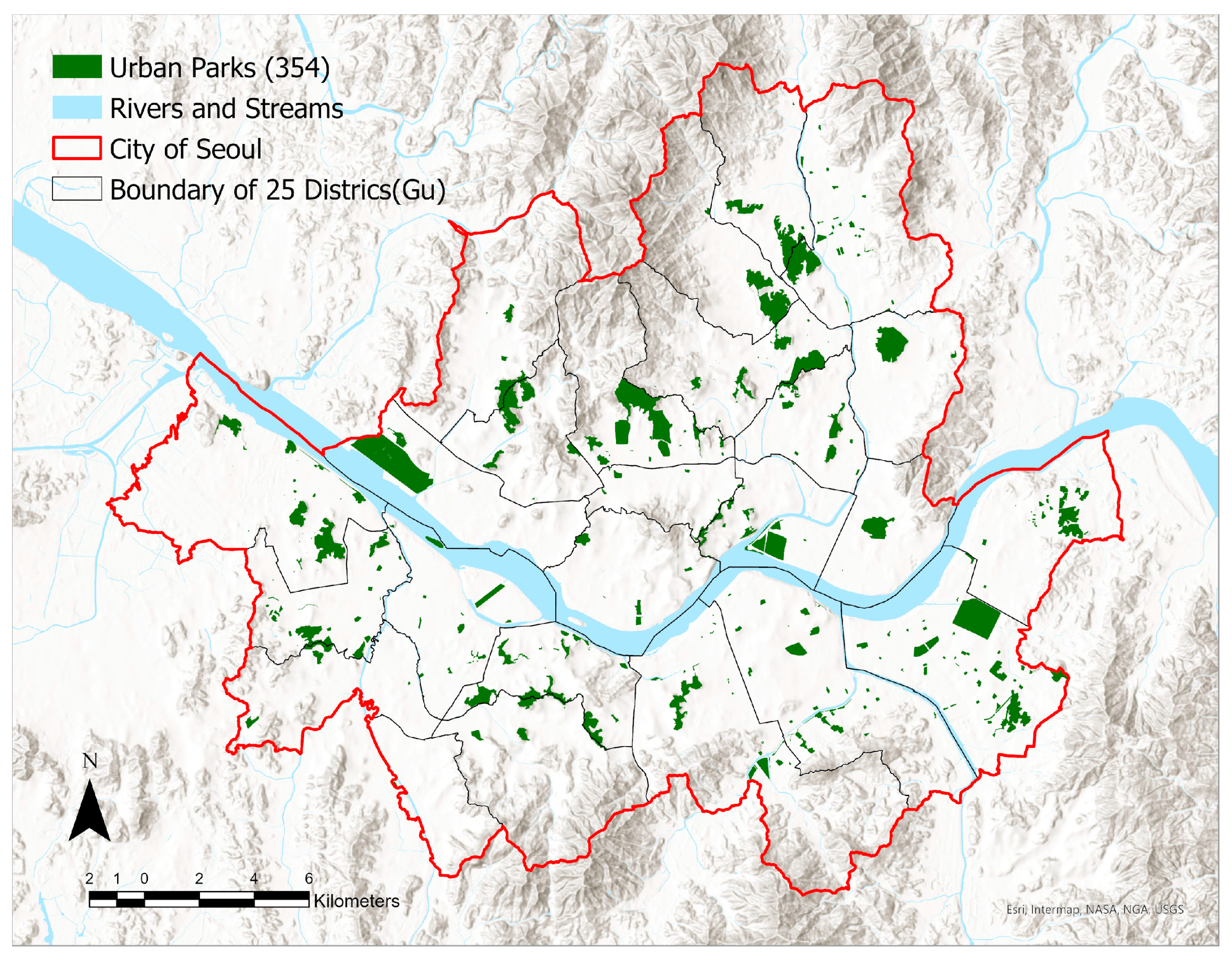
This study analyzed neighborhood parks in Seoul—with consideration of their size, availability, and accessibility—as well as “other parks” that serve similar roles. We examined the adequacy of the spatial distribution of a total of 354 urban parks in Seoul (Figure 1) and anticipated that the characteristics of their distribution would differ among the 25 autonomous districts of Seoul due to geographical, environmental, and social differences.
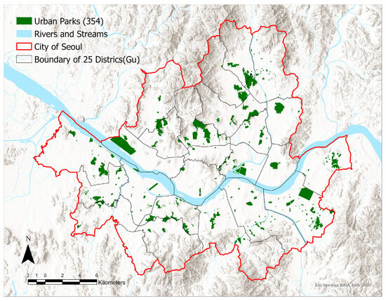
Figure 1.
Urban parks distribution in the 25 autonomous districts of Seoul.
2.1.2. Floating Population
To assess the demand for urban parks, the population census has thus far primarily been utilized. In South Korea, when establishing the “City and County Master Plan”—which presents the direction for the long-term development of each city regarding population, spatial structure, urban facilities, etc.—the total population had been calculated as the sum of the settled and the daytime population, which would then be distributed for each living-zone. The demand for facilities including urban parks had been analyzed based on such population. However, there was a limit to reflecting the population actually active or using facilities in the city, because the total number of registered residents was used in estimating the total population. There were inconsistencies between the resident-registered address and the actual living area, and disparities occurred between the costs and benefits of public service supply. In order to accurately reflect the real situation, it was suggested to expand the scope of the demand for spatial accessibility from residents to everyone within the space [21,22]. Thereafter, to overcome the limitations of resident-registered population data, a method of estimating the floating population based on big data produced mainly by telecommunication, credit card, and transportation card companies has been sought [23]. Floating population refers to those people carrying out daily life activities for a certain period of time in a certain spatial unit.
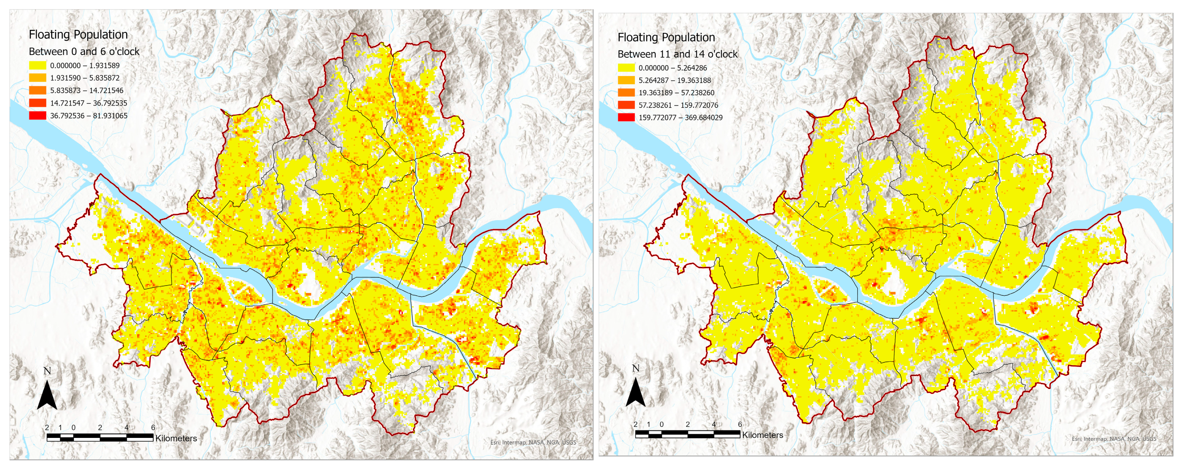
This study used big data about the floating population from Korea Telecom (KT)—a major telecommunications company in South Korea—provided by the Seoul Metropolitan Government. The data presented the average number of people estimated for weekdays, weekends, and time zones in grid units of 50 m × 50 m throughout the entirety of Seoul, based on the number of communications registered, such as calls and text messages. The floating population data were calculated per grid units of 100 m × 100 m with an allocation algorithm utilizing the total floor area and the number of floors of buildings. The average values for the floating population on weekdays and weekends in the grid units were divided into time zones of 00:00 to 05:59, 06:00 to 10:59, 11:00 to 13:59, 14:00 to 16:59, 17:00 to 20:59, and 21:00 to 23:59 (Figure 2). We used the big data of the floating population rather than those of the resident-registered population to more accurately reflect the population using urban parks and consequently derive more reliable analysis results on the distribution of and the usage characteristics of urban parks.
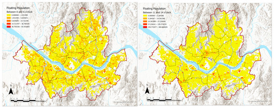
Figure 2.
Floating population at night (00:00~06:00) and during the day (11:00~14:00) in 100 m × 100 m.
2.2. Methods
2.2.1. Park Catchment Area and Walking Network
This study analyzed the adequacy of the spatial locations of urban parks by calculating urban park catchment areas within walking distances of 600 m and 900 m, in the context of the 15-minute city. The park catchment area is the space between points that can be reached by walking either 600 m or 900 m departing from each park. It may include potential users of the urban park as well as buildings and other urban spaces. We classified reasonable periods of walking to urban parks in everyday life as 10 and 15 min and assumed the average walking speed of a person to be 1 m per second. Each was then converted into the walking distances of 600 m and 900 m.
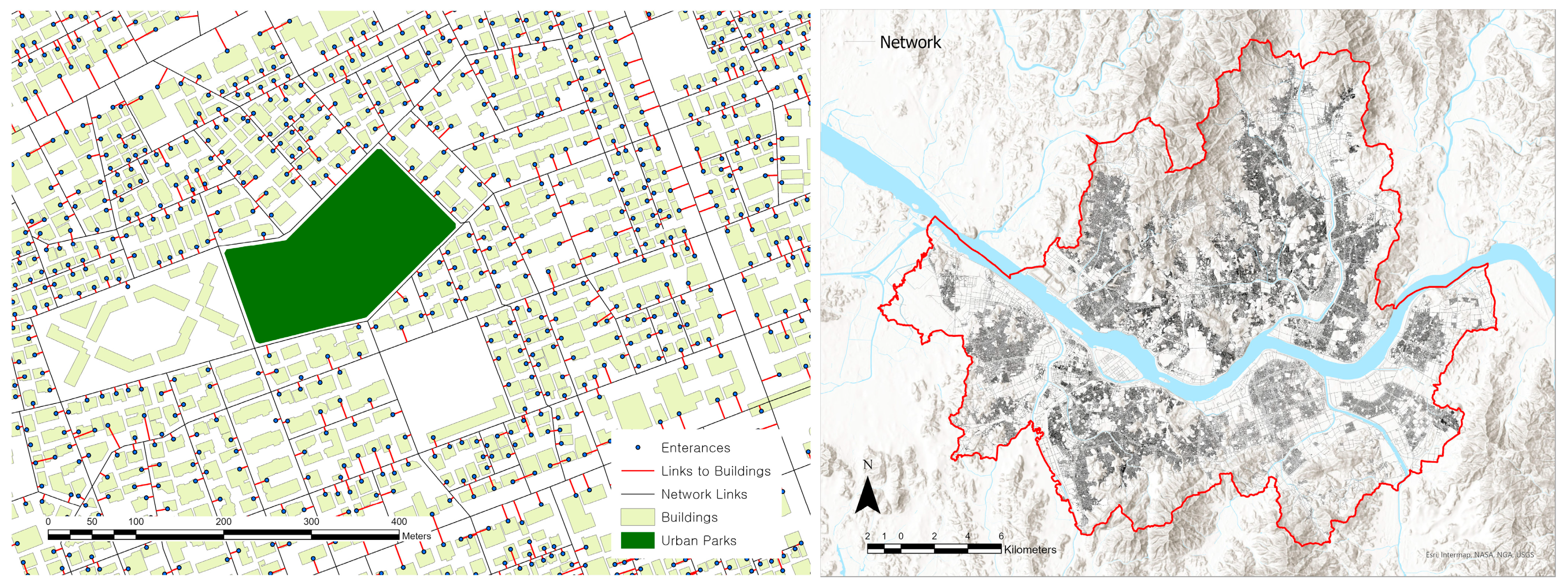
The catchment areas were calculated through actual distances traveled based on road networks rather than simple radii distances from the central point of each park. The road centerlines from the road name address system were utilized in constituting the networks. The road network information for accessing any building is organized as geographic information system (GIS) data because South Korea operates an address system based on road names and building numbers in order to resolve issues of the previous lot number address system. The road name address map reflects this new system and provides information such as legal districts, buildings, and entrances [24]. Connecting lines are established between the entrance of any building and roads in the network formed, enabling the precise calculation of the distances traveled (Figure 3). In the new system, each road section is classified into “-daero” for roads with eight or more lanes, “-ro” for those with two to seven lanes, and “-gil” for narrower roads. We reckoned that the latter represent the paths traveled by pedestrians and derived urban park catchment areas utilizing the network analysis function in the GIS (ArcGIS Pro 3.1) after establishing a walking network for Seoul as a whole [25].
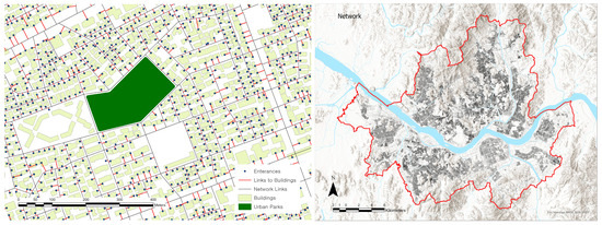
Figure 3.
Road network based on the road name address system.
2.2.2. Urban Park Distribution Evaluation Index
Based on the derived catchment areas, their area ratios and the population ratios within them, which represent the supply and demand of urban parks, respectively, were established as evaluation indices for the adequacy of urban parks’ distribution. The area ratio is that of the catchment area to the total surface of the respective administrative district. The population ratio is the proportion of the floating population in the catchment area in the total floating population of an administrative district. Since the urban park catchment areas were organically formed across grids of 100 m × 100 m, the center point of each building was used as a reference for allocating the floating population inside and outside a catchment area.
: Area ratio of urban park catchment area by administrative district.
: Area of each urban park catchment area by administrative district.
: Total area by administrative district.
: Population ratio within urban park catchment area by administrative district.
: Floating population included in each urban park catchment area by administrative district.
: Total floating population by administrative district.
3. Results
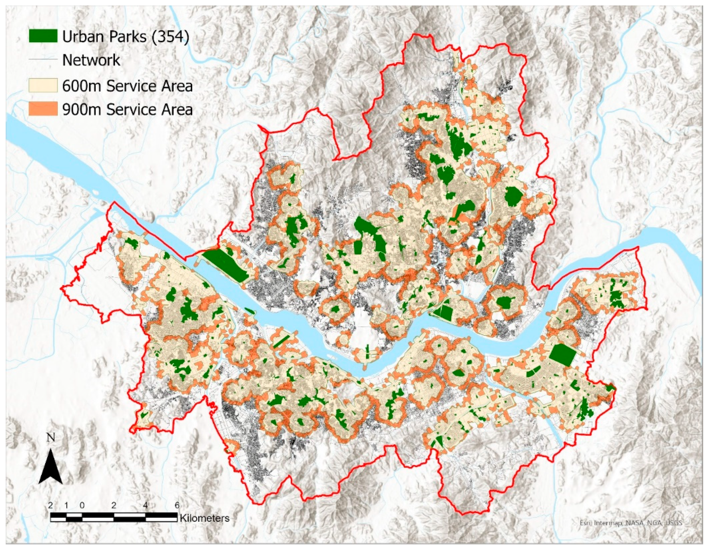
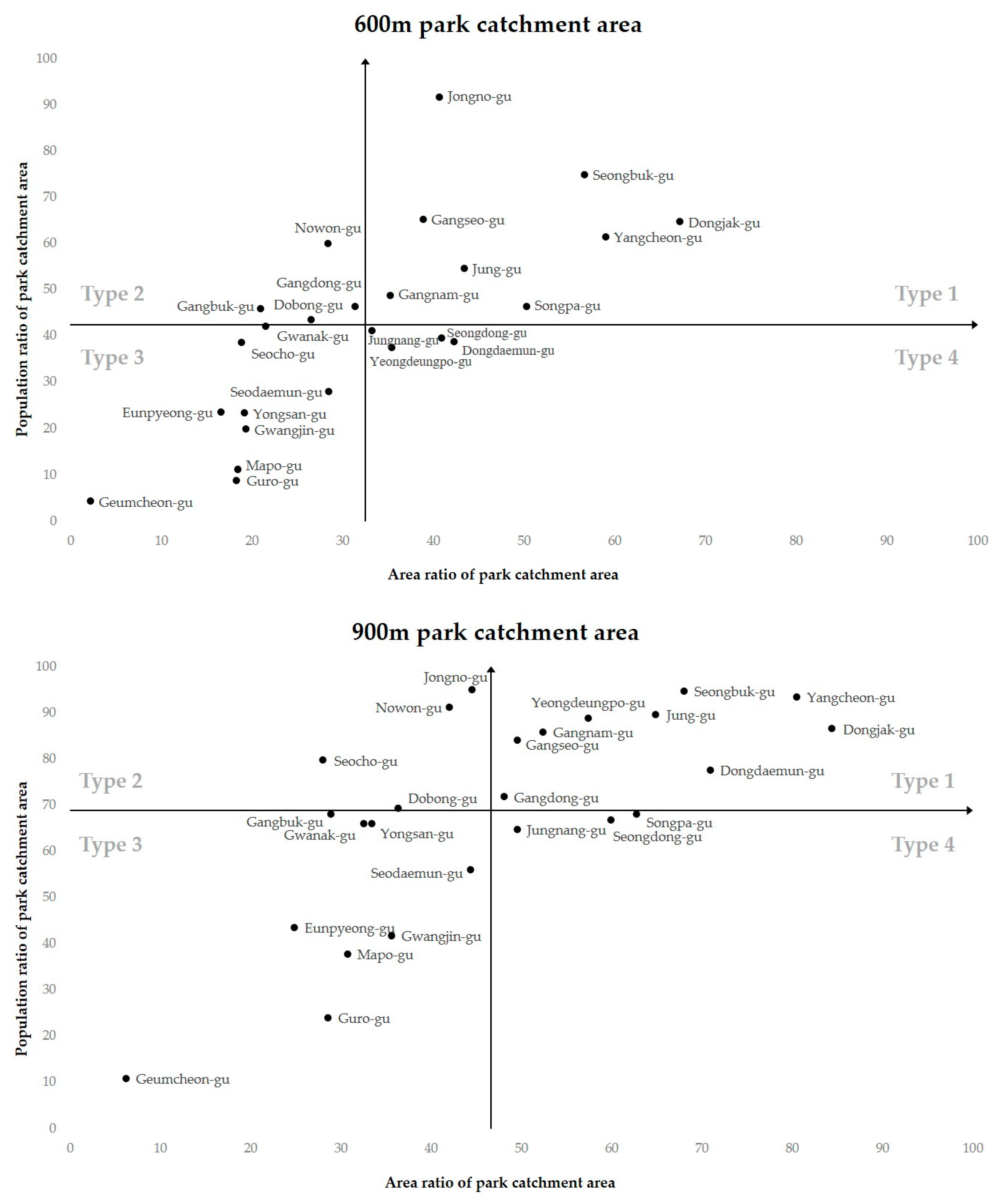
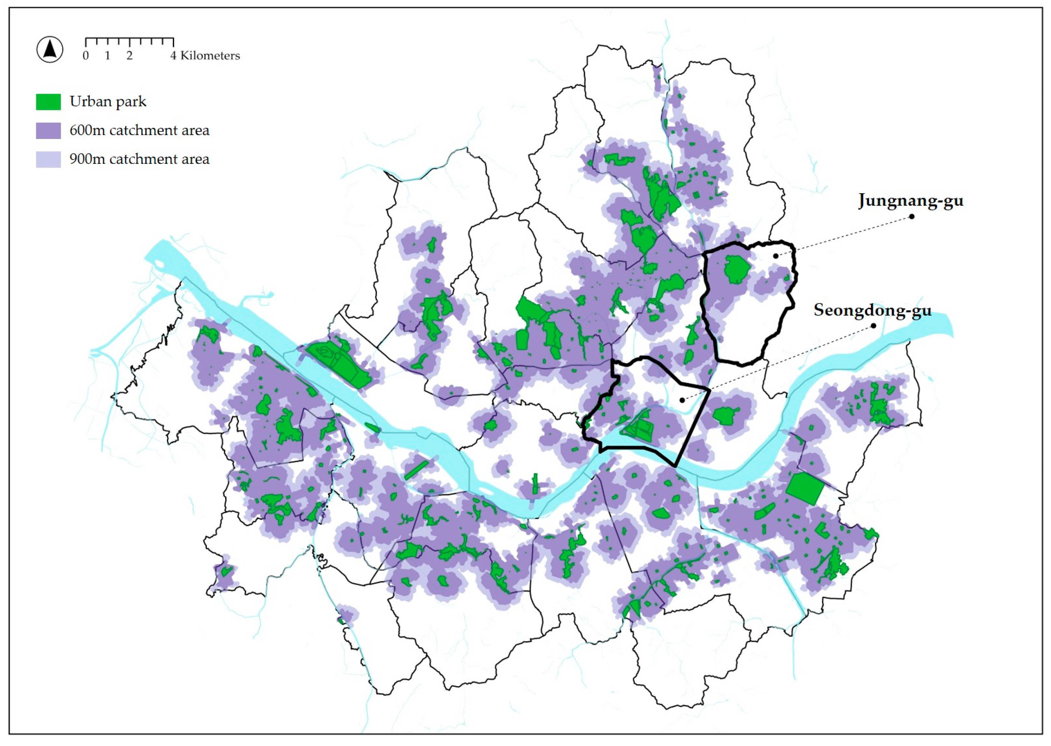
The spatial equity of urban parks was analyzed by examining the relationship between the area and population ratios for the 600 m and 900 m catchment areas, respectively, for each of the 25 autonomous districts (Figure 4). After constructing a quadrant graph with the average values of the urban park area ratio and population ratio arranged along the X- and Y-axis, respectively, the 25 local governments were classified into the following four types according to their location within the quadrants (Figure 5, Table 1). Type 1, found in the first quadrant, indicates cases where both ratios are high. Type 2, placed in the second quadrant, represents cases where the area ratio is low but the population one is high. Type 3, located in the third quadrant, comprises cases where both ratios are low. Type 4, in the fourth quadrant, indicates a high area ratio but a low population one.
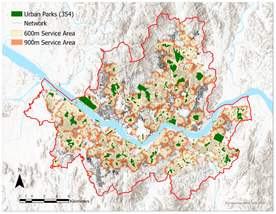
Figure 4.
Urban parks and their 600 m and 900 m catchment areas in Seoul.
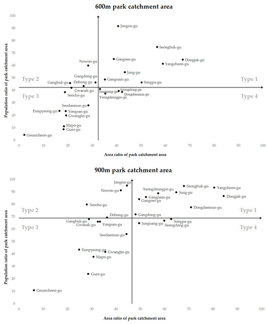
Figure 5.
Relationship between the area and population ratios for the 600 m and 900 m catchment areas for 25 districts.

Table 1.
Four types of 25 districts for urban park distribution by 600 m and 900 m park catchment areas.
3.1. Type 1: Equitably Distributed Urban Parks with Well-Matched Supply and Demand
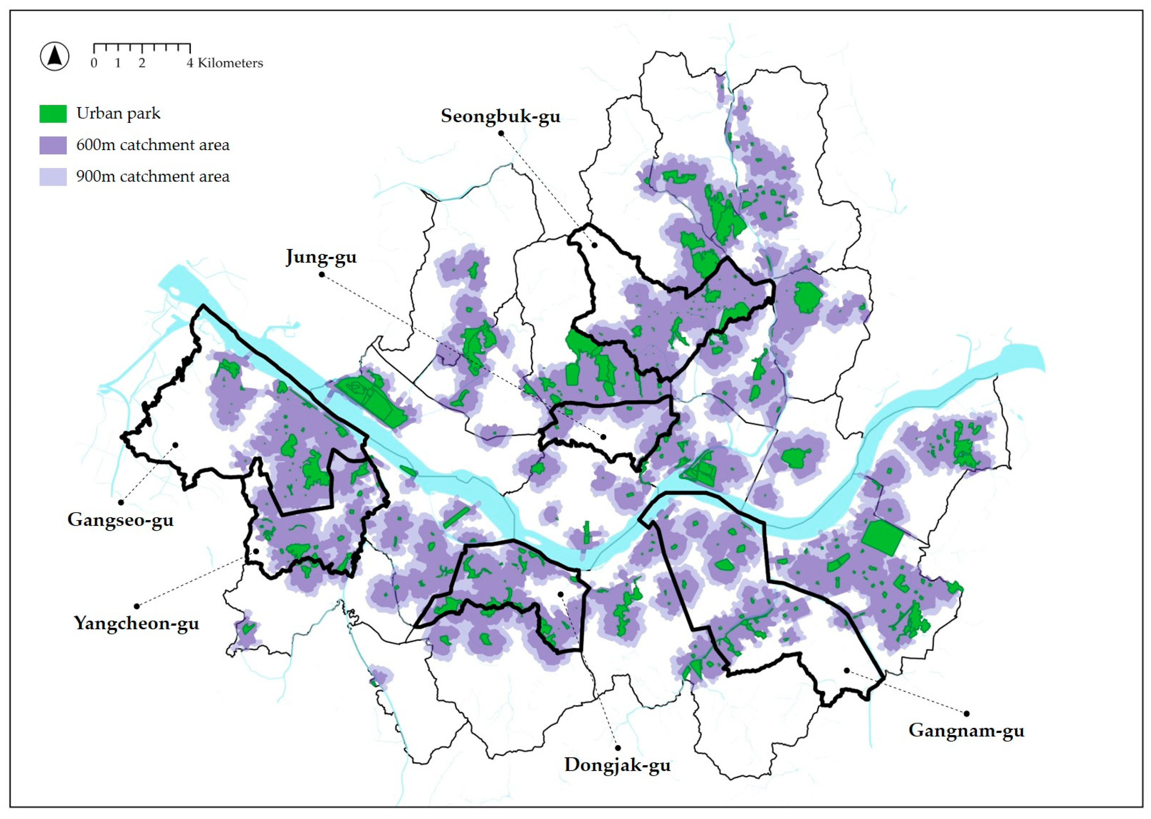
Autonomous districts belonging to Type 1 were characterized by an adequate and efficient distribution of urban parks and included eight local governments for the 600 m catchment area and nine local governments for the 900 m one. The six autonomous districts included in Type 1 for catchment areas of both distances were Gangnam-gu, Gangseo-gu, Dongjak-gu, Seongbuk-gu, Yangcheon-gu, and Jung-gu (Figure 6). Among them, Seongbuk-gu and Jung-gu were located in Gangbuk, to the north of the Han River, and the remaining four in Gangnam, to the south of the same river. Considering that the region of Seoul northern of this river is an old downtown area that has long served as a political, economic, and cultural hub while the southern region begun to be developed in the 1970s and carries two of Seoul’s three central business districts, namely the Yeouido Business District (YBD) and Gangnam Business District (GBD), there was a gap between Gangbuk and Gangnam in terms of the adequacy of urban parks’ distribution. Furthermore, Type 1 included Jung-gu and Jongno-gu, which belong to the Central Business District (CBD), Yeongdeungpo-gu, belonging to the YBD, and Gangnam-gu and Songpa-gu, belonging to the GBD. It was thereby confirmed that urban parks were evenly distributed along with a large floating population in areas where central managerial functions of the city, such as commerce, business, and transportation, were concentrated. In Dongjak-gu, the area ratios of each of the 600 m and 900 m catchment areas to the total area were 67.2% and 84.3%, respectively, the highest among the 25 autonomous districts. Hence, most of the region was located within catchment areas where urban parks are accessible within 15 min, with the exception of the Seoul National Cemetery site, which was not included in this analysis.
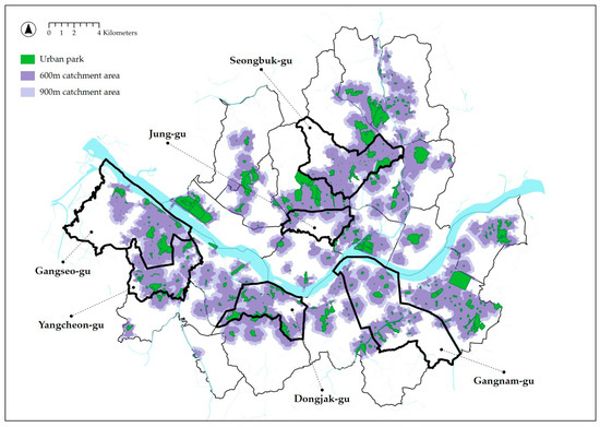
Figure 6.
Six districts belonging to Type 1 for catchment areas of both distances and their urban park distribution.
3.2. Type 2: Urban Parks with Suitable Locations but Abundant Demand
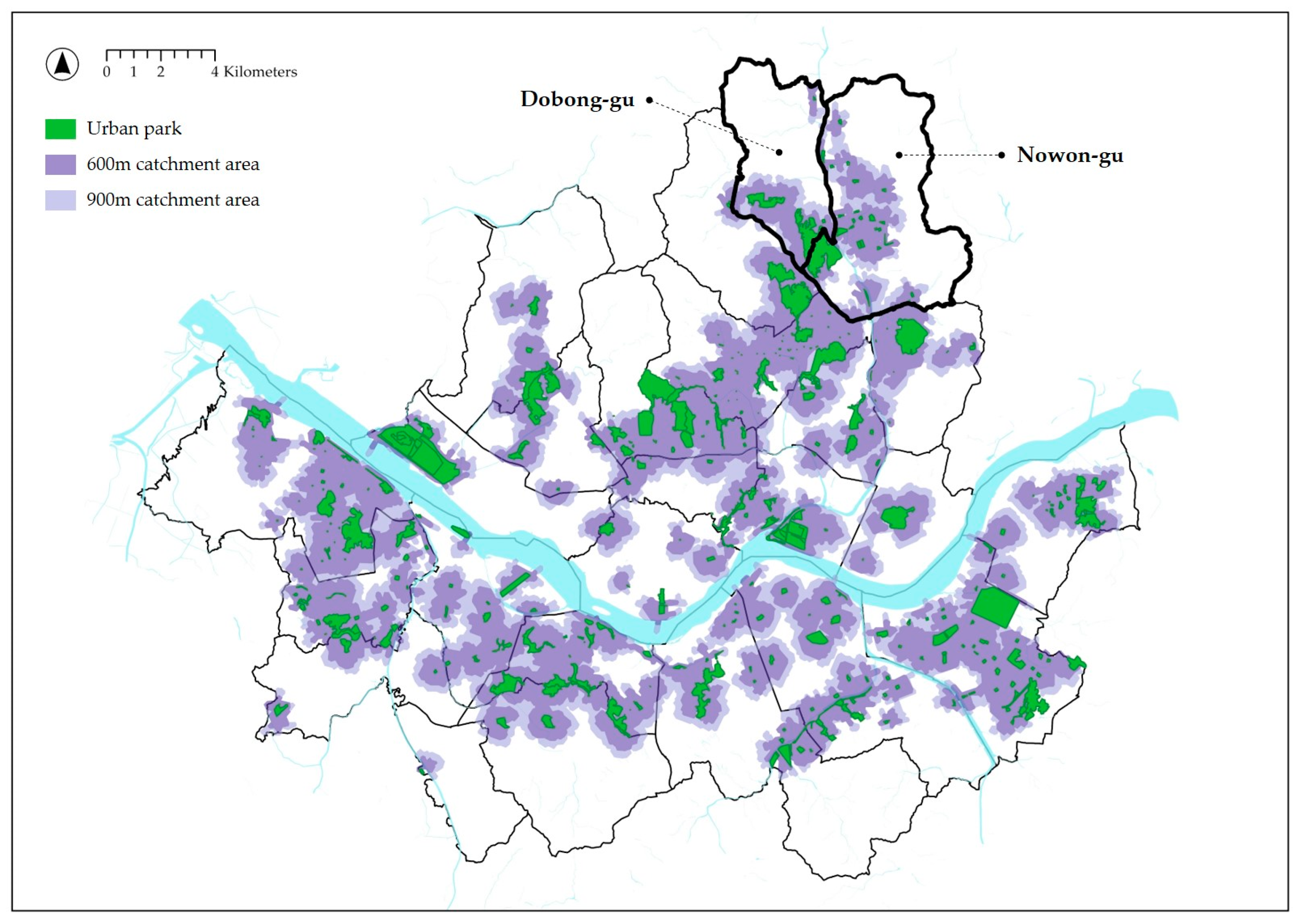
Autonomous districts belonging to Type 2 had an above-average population ratio relative to the below-average area ratio of urban park catchment areas. This indicated that, although urban parks are adequately distributed in locations where potential users are concentrated, a response is needed to address the excessive demand. Type 2 included four local governments for the 600 m catchment area and four local governments for the 900 m one. Two local governments, Nowon-gu and Dobong-gu, located in northeastern Seoul, were included in Type 2 for catchment areas of both distances (Figure 7). According to statistics from the Seoul Metropolitan Government, Dobong-gu and Nowon-gu were ranked the bottom fourth and fifth, respectively, among the twenty-five autonomous districts with per capita “walking-distance living-zone park” areas of 3.6 m2 and 3.7 m2, respectively, referring to easily accessible-on-foot and frequently used parks. This may be considered to align with the results of this study where the area ratio of the 900 m or the 15-minute urban park catchment area is below average, while the population ratio is above average in the aforementioned two districts. Furthermore, as for the geographical location of the six districts which belong to both catchment areas, four of them are part of Gangbuk and two of Gangnam. Thus, we found that, even within Seoul, the unfulfilled demand for urban parks is higher in Gangbuk than in Gangnam. For Jongno-gu, the ratio of the floating population in the 600 m and 900 m catchment areas relative to the total floating population was 91.6% and 95.0%, respectively, ranking highest among the 25 districts. However, as urban parks were concentrated in the south due to Mount Bukak located to the north, the area ratio of the 900 m catchment area in Jongno-gu was below average and was included in Type 2, characterized by a high demand relative to the low supply.
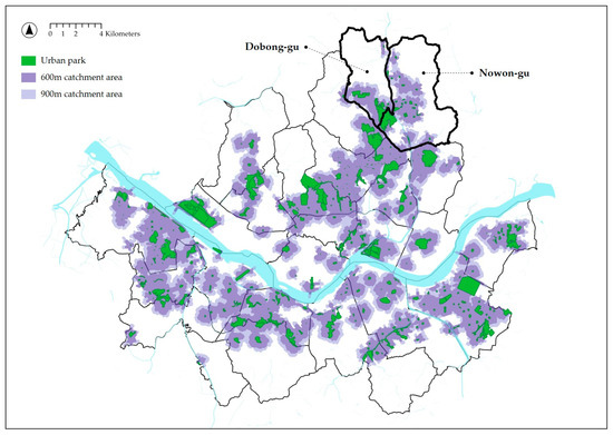
Figure 7.
Two districts belonging to Type 2 for catchment areas of both distances and their urban park distribution.
3.3. Type 3: Inappropriate Supply of and Inadequate Potential Demand for Urban Parks
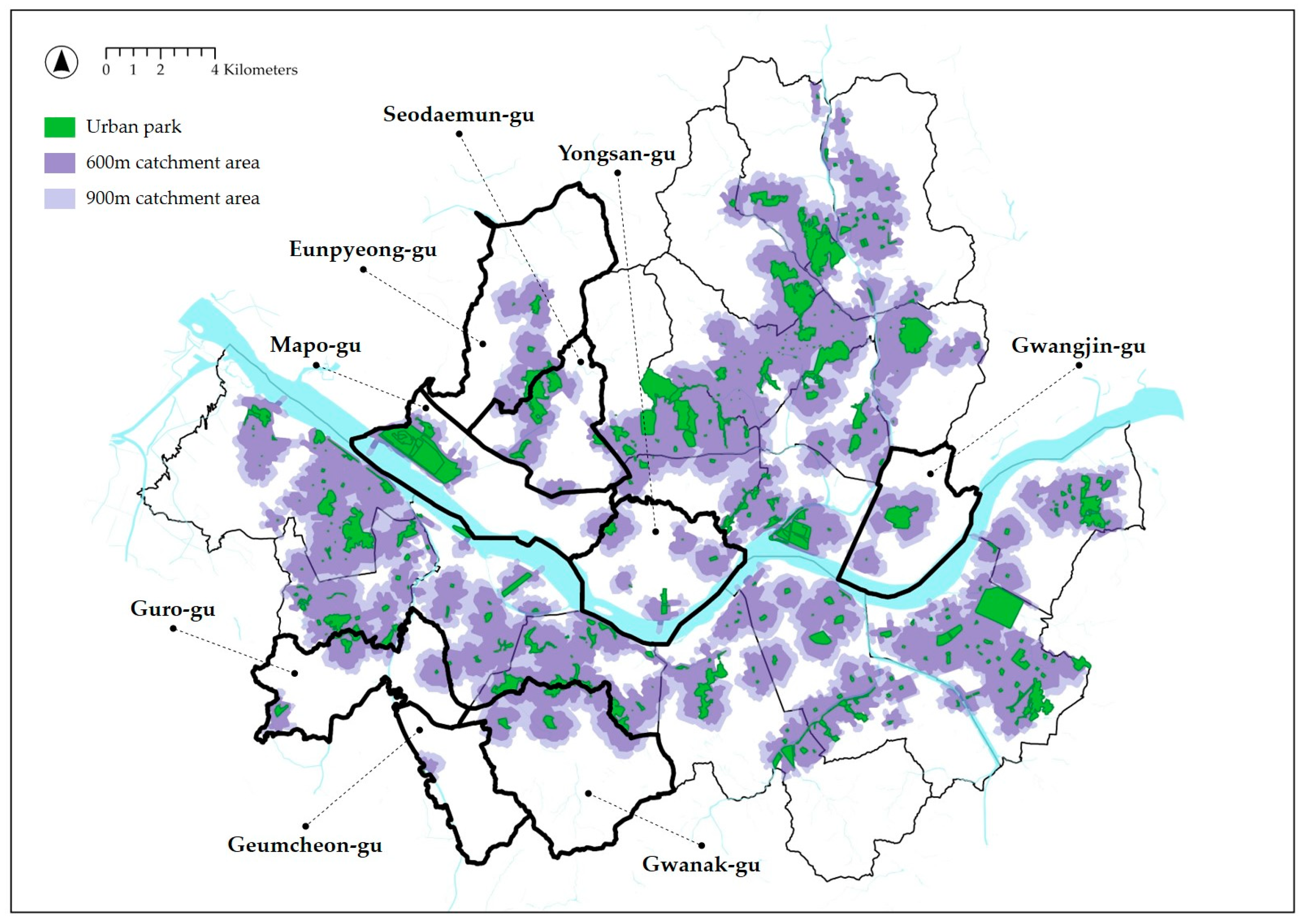
Autonomous districts belonging to Type 3 were characterized by an uneven and inadequate distribution of urban parks, with both the area and population ratios below average. Type 3 included nine local governments for the 600 m catchment area and nine local governments for the 900 m one. The eight autonomous districts included in Type 3 for both types of catchment areas were Gwanak-gu, Gwangjin-gu, Guro-gu, Geumcheon-gu, Mapo-gu, Seodaemun-gu, Yongsan-gu, and Eunpyeong-gu (Figure 8). This was the largest number of districts among the four types. With five of these districts belonging to Gangbuk and the other three to Gangnam, the regions characterized by a non-equal distribution of urban parks accounted for a larger proportion of Gangbuk relative to Gangnam. Autonomous districts belonging to Type 3 were adjacent to or included either the Han River, which crosses through the center of Seoul, or mountains inside and outside the city. Hence, the urban parks in these districts tended to be concentrated in certain regions rather than evenly distributed across the regions as a whole. Although these geospatial characteristics allow for many natural elements in the region, it may be assumed that they also limited everyday access to urban parks on foot. Furthermore, urban parks located in a spatially disproportionate manner in each district accommodated a low percentage of potential users within the 600 m and 900 m catchment areas, thereby revealing the inequality of the distribution and inefficiency of the urban park usage. In Geumcheon-gu, the area ratios of the 600 m and 900 m catchment areas to the total area were 2.2% and 6.2%, respectively, the lowest among the 25 autonomous districts. Moreover, the floating population ratios in the two types of catchment area were 4.2% and 10.8%, respectively, also the lowest among the 25 autonomous districts. There was one urban park in Geumcheon-gu within the research data, which demonstrated a clear spatial disparity in opportunities to walk to urban parks as well as their uneven distribution not only within the city but also within smaller units such as in autonomous districts and in neighborhoods.
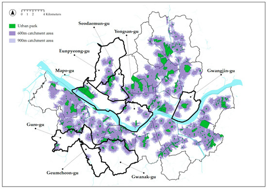
Figure 8.
Eight districts belonging to Type 3 for catchment areas of both distances and their urban park distribution.
3.4. Type 4: Urban Parks with Sufficient Supply but Insufficient Potential Users
Autonomous districts belonging to Type 4 had a below-average population ratio relative to an above-average area ratio of urban park catchment areas. This revealed a mismatch between the sufficient supply of urban parks and the demand unfulfilling expectations. Type 4 included four local governments for the 600 m catchment area and three local governments for the 900 m one. Two local governments located in northeastern Seoul, Seongdong-gu and Jungnang-gu, were included in Type 4 in catchment areas of both distances (Figure 9). To examine the locations of urban parks in the five districts in both catchment areas, the largest urban parks were Seoul Forest in Seongdong-gu, Mount Bonghwa Neighborhood Park in Jungnang-gu, Mount Baebong Neighborhood Park in Dongdaemun-gu, Yeouido Park in Yeongdeungpo-gu, and Olympic Park in Songpa-gu, while small parks were distributed around them, indicating that both types of catchment areas covered considerably large domains in each district. In fact, according to statistics from the Seoul Metropolitan Government, the walking-distance living-zone park area per capita was 10.1 m2 for Seongdong-gu, where Seoul Forest is located, ranking fourth among the 25 districts. However, it may be deemed that the urban parks in the autonomous districts belonging to Type 4 are not being used efficiently enough compared to regions in other types, as they accommodate a below-average number of potential users in an above-average urban park catchment area.
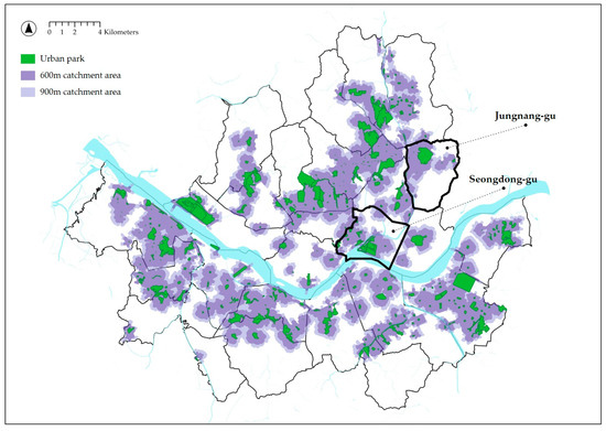
Figure 9.
Two districts belonging to Type 4 for catchment areas of both distances and their urban park distribution.
4. Discussion
Upon analyzing the relationship between the area and the population ratios of 600 m and 900 m urban park catchment areas in the 25 autonomous districts under the jurisdiction of the Seoul Metropolitan Government, the urban park distribution was classified into four types. Each type indicated whether urban parks were adequately distributed, based on the geographical location of the respective district and the urban parks therein, as well as the match or mismatch between the area ratio of the urban park catchment area representing the supply side and the population ratio of the urban park catchment area representing the demand side. The inequity in urban park distribution was noticeable not just between Seoul’s autonomous districts but even within them, at a smaller spatial scale [26]. Based on the characteristics of each type, the following implications for urban planning and policy were derived to facilitate the more equitable provision of urban parks (Table 2).

Table 2.
Characteristics of spatial equity for four types of urban park distribution and its implications.
The autonomous districts belonging to Type 1 had above-average values for both the area and population ratios of urban park catchment areas and were characterized by a balanced distribution based on the well-matched supply of and demand for urban parks. Within these districts, a high proportion of the floating population was included in a high proportion of the urban park catchment area. A significant number of potential park users had the opportunity to access adjacent urban parks on foot within 10 or 15 min. For Type 1, which demonstrated sufficient supply and demand, it was deemed that the efficiency of urban park usage could be enhanced by improving qualitative aspects, such as those of the facilities offered, rather than the quantitative aspects of urban parks. Meanwhile, in terms of the geographical location of Type 1 autonomous districts in Seoul, there was a gap between the Gangnam and Gangbuk regions: the proportion of autonomous districts exhibiting an even distribution of urban parks was found to be relatively higher in Gangnam, a planned city developed starting in the 1970s. Such geospatial gaps may be taken into consideration when calculating the number and area of urban parks and choosing their locations in the future.
The autonomous districts belonging to Type 2 demonstrated an above-average population ratio in the urban park catchment area, relative to their below-average area ratio. The insufficient supply of urban parks there failed to fulfill the excessive demand. Within these districts, a high proportion of the floating population was included in a low proportion of the urban park catchment area. Many potential users had the opportunity to access urban parks within a 10 or 15 min walking distance, but the size of the parks that could be actually enjoyed per capita was considerably small due to their insufficient supply and concentrated distribution. For Type 2, the increase in the number of urban parks could be considered in order to resolve the mismatch between supply and demand. Strategies to encourage securing sufficient urban park areas could be devised when implementing urban development or redevelopment projects.
The Type 3 districts had below-average values for both the area and population ratios of urban park catchment areas and were characterized by an uneven and inadequate distribution of urban parks. A low proportion of the floating population was included in a low proportion of the urban park catchment area. Not only was the area of urban parks accessible within a 10 to 15 min walking distance small, but the number of potential users with opportunities to access the parks was also limited. An insufficient number of urban parks was unevenly distributed in improper locations that were unable to accommodate numerous potential users. For Type 3, a redistribution of urban parks, including an increase in the area and the selection of additional locations, would be necessary to improve the below-average supply and demand. Creating urban parks in adequate locations by utilizing either long-term unexecuted urban park sites or rapidly increasing vacant dwellings or lots in the city could also help resolve the low supply and demand simultaneously. As a case in point, the Seoul Metropolitan Government is promoting “The Life-oriented Park Project”, which aims to transform existing unlicensed houses, places where waste is left unattended, and locations where disasters and safety accidents are a concern into urban parks.
The autonomous districts belonging to Type 4 had a below-average population ratio relative to the above-average area ratio of the urban park catchment area, and were characterized by an inefficient distribution of urban parks due to the mismatch between sufficient supply and insufficient demand. A low proportion of the floating population was included in a high proportion of urban park catchment area. The area of urban parks that were accessible within a 10 to 15 min walking distance was sufficient, but the number of potential users with opportunities to access the parks was limited. Considering that more than one huge park existed in most autonomous districts belonging to Type 4, supply and demand could be better matched by enhancing their walking accessibility, such as by increasing the number of entrances and physically improving access routes. The latter can involve landscaping the streets adjacent to the park, installing crosswalks and speed bumps, and creating gentle slopes for the elderly or mobility handicapped.
Meanwhile, for the seven autonomous districts belonging to different types depending on the 600 m or 900 m urban park catchment area, a change of type may have occurred due to the geospatial location of the parks and the density of floating populations, as follows: Songpa-gu (Type 1 to Type 4); Jongno-gu (Type 1 to Type 2); Gangdong-gu (Type 2 to Type 1); Gangbuk-gu (Type 2 to Type 3); Seocho-gu (Type 3 to Type 2); and Dongdaemun-gu and Yeongdeungpo-gu (Type 4 to Type 1). For Jongno-gu, when the reference value for the walking distance increased from 600 m to 900 m, the area ratio of the urban park catchment area slightly increased by approximately 3.4% from 91.6% to 95.0%, which may have been because the area of large urban parks, including Gyeongbokgung Palace, was included in an adjacent autonomous district beyond Jongno-gu. In contrast, for Gangdong-gu, the area ratio of the catchment area increased considerably by approximately 25.5% from 46.3% to 71.8% when the reference value for the walking distance changed, which may have been because small- and medium-sized urban parks were densely distributed around the center of the administrative district, and, hence, the catchment area only exerted influence within Gangdong-gu.
5. Conclusions
This study analyzed the distribution adequacy of a total of 354 urban parks in Seoul for each autonomous district based on area and population ratios for 600 m and 900 m catchment areas calculated using big data of floating population and network analysis in the context of the 15-minute city. The four types of distribution indicated that an uneven presence of urban parks was seen not only in Seoul but also in spatial units within its autonomous districts. Type 1 parks were distributed in a balanced manner based on well-matched supply and demand. Type 2 parks were distributed in an uneven manner due to insufficient supply and excessive demand. In the Type 3 distribution, both the supply and demand aspects were inadequate, while the Type 4 distribution was inefficient due to a mismatch between a sufficient supply and an insufficient demand. Implications for urban planning and policy were presented for each type, such as qualitative improvement, quantitative increase, redistribution, and optimization of accessibility.
This study is significant in that it recognizes that the resident-registered population data, which had been utilized in previous studies to assess the accessibility of urban facilities, are limited in reflecting the actual number of users. Conversely, the study conducted a detailed analysis of the adequacy of urban parks’ distribution by employing big data about the floating population. We believe that the results regarding the spatial equity of such a distribution will aid policymakers and local authorities in assessing the efficiency of the current supply and preparing appropriate measures for the disadvantaged areas. Furthermore, this study can be used as basic research for selecting the optimal location of urban facilities, including parks, through the elaboration of data and methodology. Meanwhile, its limitation is that it used data from 354 urban parks along a single hierarchy and data from average weekday and weekend values of the floating population within the spatial units of 25 autonomous districts under the jurisdiction of the Seoul Metropolitan Government. We anticipate that research contents may be further advanced by categorizing urban parks, subdividing floating populations according to days and time zones, and accounting for users’ socio-demographic characteristics such as being elderly or children. Ultimately, by reflecting on the characteristics of a specific group in the process of planning, creating, and managing urban parks, it may be possible to realize spatial equity that appropriately fulfills the needs of each group rather than providing the same facilities and services to everyone in the same manner.
Author Contributions
Conceptualization, Y.J. and S.J.; methodology, S.J.; software, Y.J. and S.J.; formal analysis, Y.J. and S.J.; data curation, S.J.; writing—original draft preparation, Y.J.; writing—review and editing, Y.J.; supervision, S.J. All authors have read and agreed to the published version of the manuscript.
Funding
This work is supported by the Korea Agency for Infrastructure Technology Advancement (KAIA) grant funded by the Ministry of Land, Infrastructure and Transport (RS-2022-00143404).
Data Availability Statement
The data presented in this study are available on request from the corresponding author. The data are not publicly available due to the use of 3rd Party Data. This study used the dataset delivered by Big Value Co., Ltd. after processing and treating the floating population big data from Korea Telecom, provided by the Seoul Metropolitan Government.
Conflicts of Interest
The authors declare no conflicts of interest.
References
- Jalkanen, J.; Fabritius, H.; Vierikko, K.; Moilanen, A.; Toivonen, T. Analyzing fair access to urban green areas using multimodal accessibility measures and spatial prioritization. Appl. Geogr. 2020, 124, 102320. [Google Scholar] [CrossRef]
- Dony, C.C.; Delmelle, E.M.; Delmelle, E.C. Re-conceptualizing accessibility to parks in multi-modal cities: A variable-width floating catchment area (VFCA) method. Landsc. Urban Plan. 2015, 143, 90–99. [Google Scholar] [CrossRef]
- Ibes, D.C. A multi-dimensional classification and equity analysis of an urban park system: A novel methodology and case study application. Landsc. Urban Plan. 2015, 137, 122–137. [Google Scholar] [CrossRef]
- Lee, G.; Hong, I. Measuring spatial accessibility in the context of spatial disparity between demand and supply of urban park service. Landsc. Urban Plan. 2013, 119, 85–90. [Google Scholar] [CrossRef]
- Liu, B.; Tian, Y.; Guo, M.; Tran, D.; Alwah, A.A.Q.; Xu, D. Evaluating the disparity between supply and demand of park green space using a multi-dimensional spatial equity evaluation framework. Cities 2022, 121, 103484. [Google Scholar] [CrossRef]
- Reyes, M.; Páez, A.; Morency, C. Walking accessibility to urban parks by children: A case study of Montreal. Landsc. Urban Plan. 2014, 125, 38–47. [Google Scholar] [CrossRef]
- Yang, W.; Yang, R.; Zhou, S. The spatial heterogeneity of urban green space inequity from a perspective of the vulnerable: A case study of Guangzhou, China. Cities 2022, 130, 103855. [Google Scholar] [CrossRef]
- Zhang, J.; Tan, P.Y. Assessment of spatial equity of urban park distribution from the perspective of supply-demand interactions. Urban For. Urban Green. 2023, 80, 127827. [Google Scholar] [CrossRef]
- Zhang, R.; Zhang, C.Q.; Cheng, W.; Lai, P.C.; Schüz, B. The neighborhood socioeconomic inequalities in urban parks in a high-density city: An environmental justice perspective. Landsc. Urban Plan. 2021, 211, 104099. [Google Scholar] [CrossRef]
- Zhang, D.; Ma, S.; Fan, J.; Xie, D.; Jiang, H.; Wang, G. Assessing spatial equity in urban park accessibility: An improve two-step catchment area method from the perspective of 15-minute city concept. Sustain. Cities Soc. 2023, 98, 104824. [Google Scholar] [CrossRef]
- Yang, Y.; He, R.; Tian, G.; Shi, Z.; Wang, X.; Fekete, A. Equity Study on Urban Park Accessibility Based on Improved 2SFCA Method in Zhengzhou, China. Land 2022, 11, 2045. [Google Scholar] [CrossRef]
- Cao, Y.; Guo, Y.; Zhang, M. Research on the Equity of Urban Green Park Space Layout Based on Ga2SFCA Optimization Method—Taking the Core Area of Beijing as an Example. Land 2022, 11, 1323. [Google Scholar] [CrossRef]
- Tahmasbi, B.; Mansourianfar, M.H.; Haghshenas, H.; Kim, I. Multimodal accessibility-based equity assessment of urban public facilities distribution. Sustain. Cities Soc. 2019, 49, 101633. [Google Scholar] [CrossRef]
- Bahrini, F.; Bell, S.; Mokhtarzadeh, S. The relationship between the distribution and use patterns of parks and their spatial accessibility at the city level: A case study from Tehran, Iran. Urban For. Urban Green. 2017, 27, 332–342. [Google Scholar] [CrossRef]
- Boone, C.G.; Buckley, G.L.; Grove, J.M.; Sister, C. Parks and people: An environmental justice inquiry in Baltimore, Maryland. Ann. Assoc. Am. Geogr. 2009, 99, 767–787. [Google Scholar] [CrossRef]
- Hu, S.; Song, W.; Li, C.; Lu, J. A multi-mode Gaussian-based two-step floating catchment area method for measuring accessibility of urban parks. Cities 2020, 105, 102815. [Google Scholar] [CrossRef]
- Rigolon, A. A complex landscape of inequity in access to urban parks: A literature review. Landsc. Urban Plan. 2016, 153, 160–169. [Google Scholar] [CrossRef]
- Xing, L.; Liu, Y.; Liu, X.; Wei, X.; Mao, Y. Spatio-temporal disparity between demand and supply of park green space service in urban area of Wuhan from 2000 to 2014. Habitat Int. 2018, 71, 49–59. [Google Scholar] [CrossRef]
- Zhang, R.; Peng, S.; Sun, F.; Deng, L.; Che, Y. Assessing the social equity of urban parks: An improved index integrating multiple quality dimensions and service accessibility. Cities 2022, 129, 103839. [Google Scholar] [CrossRef]
- Jacobs, J. The Death and Life of Great American Cities; Random House: New York, NY, USA, 1961. [Google Scholar]
- Lee, W.; Sohn, S.; Heo, J. Utilizing mobile phone-based floating population data to measure the spatial accessibility to public transit. Appl. Geogr. 2018, 92, 123–130. [Google Scholar] [CrossRef]
- Ryan, R.L. The social landscape of planning: Integrating social and perceptual research with spatial planning information. Landsc. Urban Plan. 2011, 100, 361–363. [Google Scholar] [CrossRef]
- Xiao, Y.; Wang, D.; Fang, J. Exploring the disparities in park access through mobile phone data: Evidence from Shanghai, China. Landsc. Urban Plan. 2019, 181, 80–91. [Google Scholar] [CrossRef]
- Je, M.; Jung, S. Development of methodology to precisely evaluate the distribution of urban parks: Using the map of Road Name Address System and GIS network analysis. Korea Inst. Ecol. Archit. Environ. 2020, 20, 73–80. (In Korean) [Google Scholar]
- Oh, K.; Jeong, S. Assessing the spatial distribution of urban parks using GIS. Landsc. Urban Plan. 2007, 82, 25–32. [Google Scholar] [CrossRef]
- Tan, P.Y.; Samsudin, R. Effects of spatial scale on assessment of spatial equity of urban park provision. Landsc. Urban Plan. 2017, 158, 139–154. [Google Scholar] [CrossRef]
Disclaimer/Publisher’s Note: The statements, opinions and data contained in all publications are solely those of the individual author(s) and contributor(s) and not of MDPI and/or the editor(s). MDPI and/or the editor(s) disclaim responsibility for any injury to people or property resulting from any ideas, methods, instructions or products referred to in the content. |
© 2023 by the authors. Licensee MDPI, Basel, Switzerland. This article is an open access article distributed under the terms and conditions of the Creative Commons Attribution (CC BY) license (https://creativecommons.org/licenses/by/4.0/).

