Abstract
Agroecosystems represent one of the largest managed systems in the world and are also considered to be the largest surface polluters. This is particularly evident in highly vulnerable areas such as the model area assessed in our study, the Protected Water Management Area Žitný Ostrov, which contains the most productive soils in the Slovak Republic. At the same time, the Žitný Ostrov represents the largest groundwater reserves in Central Europe. We based this study on the information system of valued soil ecological units (VSEUs) and their spatial extension to the agricultural soils of Slovakia. We used the synthetic–parametric method for a summary (aggregated) evaluation of the production potential of provisioning soil services, which we have classified into 10 categories (1—very low potential; 10—very high potential). Overall, there were 3000 individual VSEUs identified in the area of interest. By eliminating repetitive VSEUs, we evaluated 72 subtypes and, based on similarity parameters, they were further aggregated into 40 soil subtypes. The result is a spatial representation of the proposed zones within the model area (zones for sustainable economic use of soils with the support for ecologization of agricultural technologies, non-productive land use, cultural and social development of rural areas, and the protection and revitalization of the landscape and its components). The approach is also suitable for use in other areas.
1. Introduction
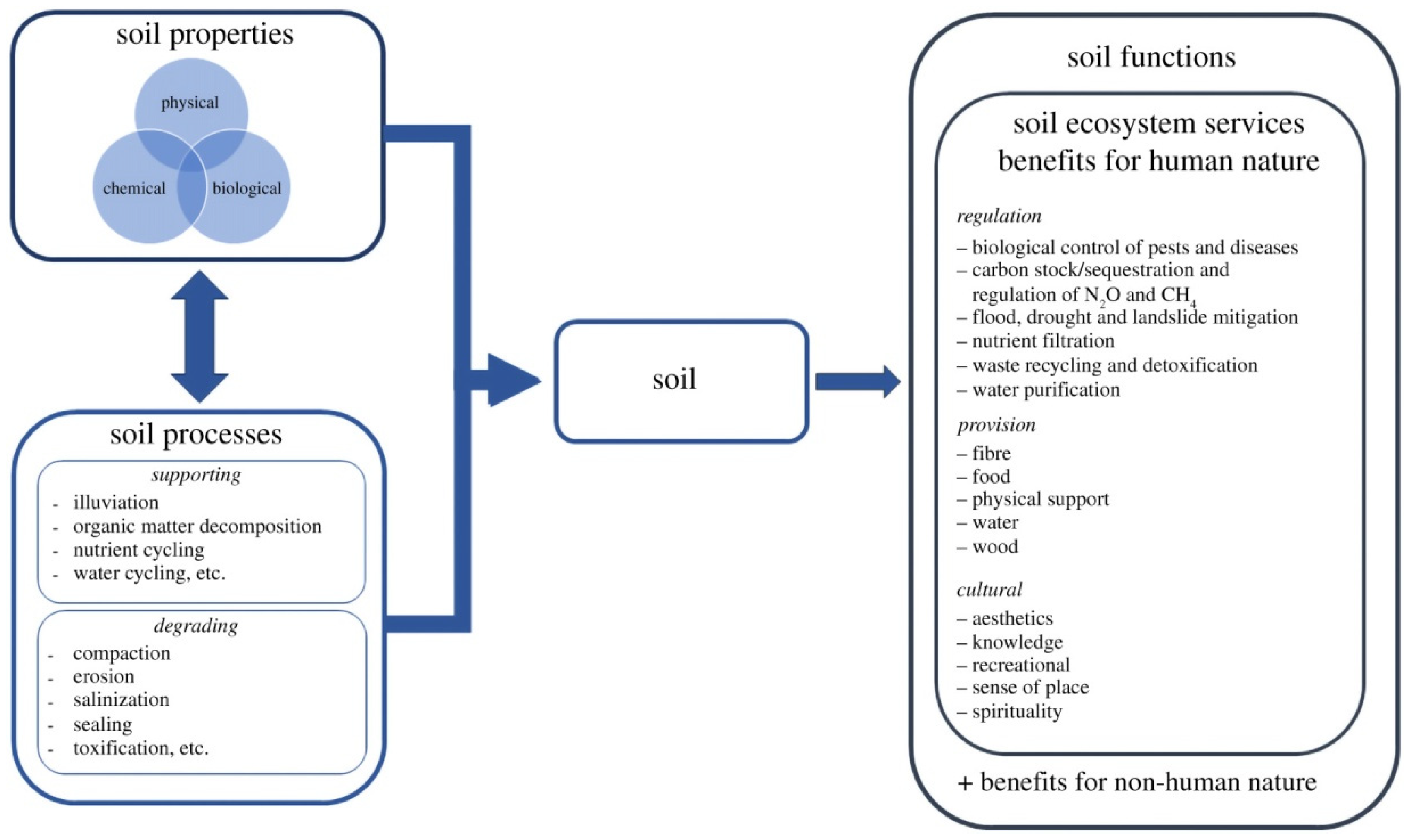
Soils that are a part of the natural capital provide a number of ecosystem services that go way beyond agricultural production [1]. Soil ecosystem services (SES) are varied, valuable, and underappreciated. They are classified as regulating, provisioning, and cultural services (Figure 1). The value of SES exceeds the value of other parts of the ecosystem, but their scope and value are still insufficiently understood [2]. Taking soil ecosystem services into consideration is crucial to improve agricultural production systems in order to reduce yield gaps [3]. The increasing demand for agricultural products puts pressure on the further intensification of crop production. Sustainable intensification means the ecological substitution of anthropogenic inputs and/or an increase in crop productivity by incorporating the regulation and support of ecosystem services management into agricultural practices [4].
The ability of soil to maintain any of its functions and sustain the provision of its ecosystem services depends on its physical, biological, and chemical characteristics (i.e., “internal” characteristics). The actualization of the performance is constrained by natural (such as parent material and slope inclination) and/or anthropogenic factors (i.e., “external” controls) [5].

Figure 1.
Illustrative framework of SES and their associated concepts—soil properties, soil processes, and soil functions. This framework has been adapted based on the hypothesis provided by [6].
Figure 1.
Illustrative framework of SES and their associated concepts—soil properties, soil processes, and soil functions. This framework has been adapted based on the hypothesis provided by [6].
Detailed knowledge of soil properties and climatological data plays a significant role in the optimization of agricultural practices and agroecosystem management. Meanwhile, the spatial distribution of physical–chemical soil properties is considered to serve as the basis for any sustainable agricultural planning [7].
The issue of the expanding population and declining soil production has persisted for a long time. The requirement to increase production per unit of land is rising quickly [8]. This poses a threat to food security and the sustainable development of agriculture and the environment [9]. Soil fertility is affected by numerous factors. The diverse utilization of soil within a municipality, district, or zone is influenced by its heterogeneity within those areas. In order to make the most of the limited soil resources, thorough knowledge of their characteristics, typology, and distribution within the landscape is necessary. This increases the need for geospatial soil data delineating unique production zones suited for the provision of selected SES [10].
The maintenance of ecosystems and also high crop yields depends on the availability of soil macronutrients. When the available macronutrients in soils are excessive, imbalanced fertilization can potentially be harmful to water resources because it degrades the soil’s fertility and decreases productivity. The available macronutrients can also be transported off-site by runoff from irrigation or rain, which further reduces soil productivity. Numerous studies have shown a high within-field variability of soil characteristics resulting in the variability of crop yields [11]. Therefore, farmers must be encouraged to balance the use of fertilizers and manure, special soil amendments (if any), and correctly adopt optimal cropping patterns in order to meet the need for high agricultural output without harming the environment [7,12]. Soil health must therefore be maintained by assessing the soil’s fertility and promoting the recommendations of soil tests for balanced nutrition to maintain soil health.
A significant fertility factor that influences a number of soil characteristics and, in turn, the quality of the soil and ecological processes is soil organic carbon [13,14]. Soils are large sources of terrestrial carbon and contribute significantly to both the global carbon cycle and climate change [15,16]. However, anthropogenic disturbances have been a major factor in soil loss and carbon stock degradation. Due to desertification, salinization, wind and water erosion, and improper agricultural practices, soils have degraded unabatedly and at an alarming rate [14].
Organic carbon pools and carbon lability have a direct impact on the physical, chemical, and biological characteristics of soil as well as its ability to self-organize [17,18]. Because of this, their inclusion in the carbon management index may be a crucial parameter for determining how well management systems may improve soil quality [19,20,21,22].
The depletion of soil organic carbon reserves has created a soil carbon deficit, which represents an opportunity for carbon sequestration in the soil via various soil management approaches. Potential change in soil carbon in the future is, however, influenced by various factors, including climate change, historical models of soil use, current soil management strategies, and topographic heterogeneity [23].
Agricultural landscapes vary greatly in terms of their structure and purpose. This diversity is shaped and preserved in large part by traditional farming practices that have developed as a result of prolonged interactions between humans and the natural world [24]. Due to the fact that these land use systems produce integrated social–ecological benefits, the special values of traditional agriculture have been studied in relation to biodiversity and cultural features. In regions dominated by intensive agricultural practices, traditional agricultural landscapes represent hotspots, in particular for regulating and cultural ecosystem services and biodiversity [25].
When selecting suitable sites for implementing technologically soft ecological agriculture, it is crucial to respect the soil site attributes and climate conditions for sustainable agriculture. The most suitable application of ecological farming practices is in areas with special ecological regimes, such as national parks, protected landscape areas, sanitary protection zones of water sources, and zones of alpine and sub-alpine areas [26].
Ecologically oriented management favors “soft” technologically non-demanding regenerative solutions. It directs and controls precipitation and runoff at the place of its occurrence through vegetation and terrain adjustments. The aim is to retain water to support a hydrological regime using techniques that will enable water infiltration and its storage in deeper soil layers and enable its natural evaporation as well [27,28]. To establish organic agriculture as an important tool in sustainable food production, the factors limiting organic yields need to be more fully understood, along with assessments of the many social, environmental, and economic benefits of organic farming systems [28].
Soils, which are managed using organic methods, show better water retention capabilities and have a higher rate of water infiltration. This is also one of the reasons why soft forms of organic systems are often considered more resilient and have a higher yield stability, even in drought conditions [29,30]. On the other hand, organic systems are sometimes more susceptible to pest outbreaks, which can lead to yield losses and higher yield variability [31]. This is especially relevant in highly vulnerable areas of the Slovak Republic, such as the Protected Water Management Area Žitný Ostrov. Here, we can find the most productive soil types: chernozem, cutanic luvisol, and mollic fluvisol, and at the same time, the biggest groundwater reserves in Central Europe.
In 2023, the government of the Slovak Republic approved the Action Plan for Water Protection in the Žitný Ostrov Protected Water Management Area. The vision is to ensure that the public interest of water protection in the area is prioritised so that the use of drinking water resources for public supply takes priority in landscape and spatial planning over economic and other uses of the area.
This study has an applied aspect that presents a proposal for sustainable management of highly vulnerable landscapes, and it is a basis for further environmental analyses of the area. The aim of this study is to demarcate zones of optimal multifunctional use of agricultural landscapes based on the determination of provisioning ecosystem services (soil productivity), taking into account the climate conditions in the model area for the following:
- -
- Sustainable economic use of soils with the support for ecologization of agricultural technologies.
- -
- Non-productive land use and the cultural and social development of rural areas.
- -
- Protection and revitalization of the landscape and its components.
2. Methodology
2.1. Model Area
The entire area of Žitný Ostrov is a vast groundwater reserve and one of the most fertile agricultural areas in Slovakia. It is located in the southwest of Slovakia. It creates a terrestrial “island” between the Danube River and its branch, the Little Danube. It has a mild to moderately warm climate, and the most fertile soils of Slovakia are located here.
The Protected Water Management Area Žitný Ostrov covers 1550 km2, which accounts for 2.86% of the total land area of the Slovak Republic; agricultural land covers 1500 km2; and forests cover 50 km2 [32]. The main towns on the island are Komárno, Dunajská Streda, and Šamorín, and the suburbs of Bratislava (Vrakuňa and Podunajské Biskupice) are also located on the island. The main industrial factory located here is the Slovnaft refinery. In the area, the Gabčíkovo Hydrological Dam was built in 1977–1992, mainly for flood protection, improvements in water transportation, drinking water provision, and electricity production.
The predominant land use in the area is agriculture, which represents as much as 77.8% of its total area (compared to 48% of agricultural land in Slovakia). The largest proportion (71.4%) represents non-irrigated arable land. Urbanized and industrial areas cover 10.2%, of which 8.3% are discontinuous built-up areas and 1.9% are industrial and other small sites. These land use forms, together with agriculturally used areas, represent potential sources of diffuse pollution and account for 88% of the area [32]. The remaining 12% are land use types, which are not potential sources of diffuse pollution, including landfills, ports, and mining (Figure 2).
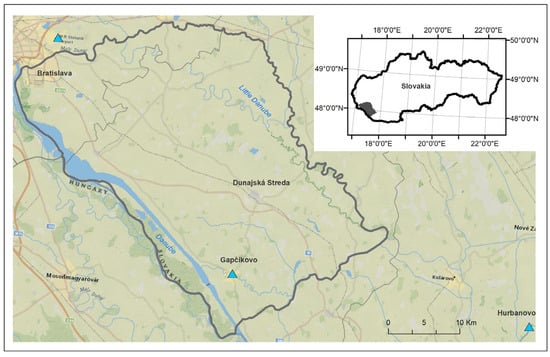
Figure 2.
The model area of the Protected Water Management Area Žitný Ostrov. Blue triangles show locations of meteorological stations.
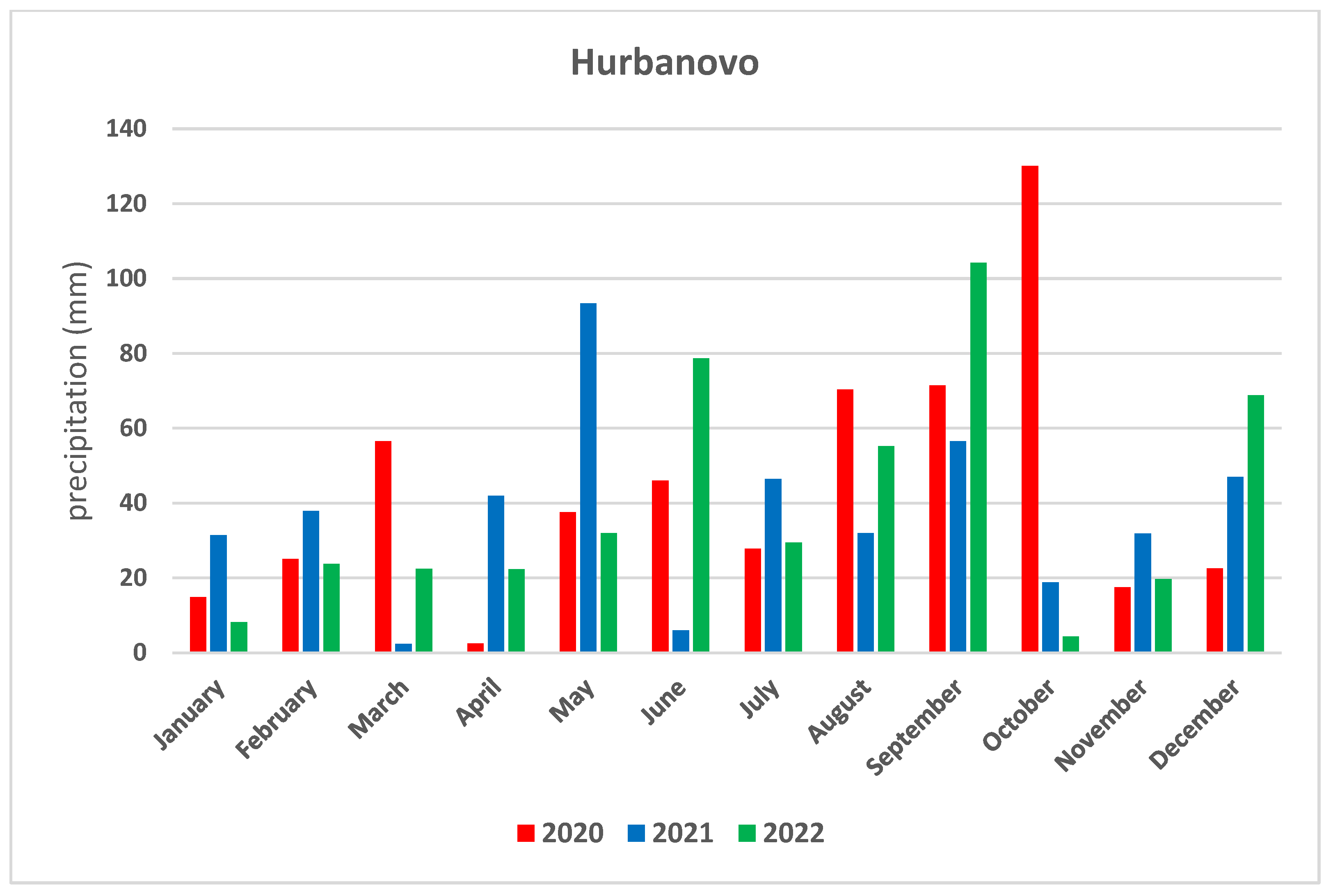
The amount of precipitation in the past 3 years (2020, 2021, and 2022) is given from the meteorological stations located at Gabčíkovo Hydrological Dam, Hurbanovo, and Bratislava airport [33]. In the spring of 2020, all three stations experienced very dry to exceptionally dry conditions. During the summer, there was a significant variation in the atmospheric precipitation in these stations, with Hurbanovo ending up as very dry, while the other two stations had a normal, exceptionally humid summer. The autumn was very, even exceptionally, humid in the given area. The year as a whole was considered normal, with Gabčíkovo being the most humid.
The spring of 2021 was normal to very dry in the given area. The summer was characterized by uneven precipitation distribution, and it was extremely dry in Hurbanovo, while Gabčíkovo experienced a normal summer. The amount of precipitation distribution in the locations was again uneven in autumn, with autumn being normal at Bratislava airport, but it was very dry in Hurbanovo. The end of the year was characterized as normal in Gabčíkovo and very dry in Hurbanovo [33].
The spring of 2022 was dry to exceptionally dry in the given area. There was once again an uneven distribution of atmospheric precipitation during the summer, with Hurbanovo having a dry summer, Bratislava airport received slightly above-average precipitation, and Gabčíkovo received below-average precipitation. The autumn was dry to exceptionally dry. The year as a whole in the given area was dry to very dry [33] (Figure 3, Figure 4 and Figure 5).
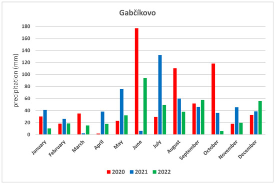
Figure 3.
Atmospheric precipitation in the Gabčíkovo location (2020–2022).
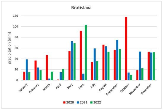
Figure 4.
Atmospheric precipitation in Bratislava airport location (2020–2022).

Figure 5.
Atmospheric precipitation in Hurbanovo location (2020–2022).
More than 16% of Slovakia’s population lives in areas with the highest degree of risk from extreme heat events. Threatened regions are concentrated in the southwest of the country around the capital and Žitný Ostrov but also in the south of central Slovakia. At the same time, the districts of Bratislava I, Komárno, and Nové Zámky are currently among the places with the highest average number of tropical days per year. In the town of Hurbanovo in the district of Komárno, the highest temperature in Slovakia (40.3 °C) was measured in 2007.
2.2. Methods
As the basis for evaluation of supporting SES, we used the soil information system of Valued Soil Ecological Units (VSEUs), operated by the Soil Science and Conservation Research Institute (VUPOP) in Bratislava [34]. The VSEU (Figure 6) represents homogenous, well-defined spatial units. These units were created as a result of the spatial interpolation of the whole complex of the environmental components such as soil, climate, and topography, which represent specific ecological characteristic influencing soil production potential [35].
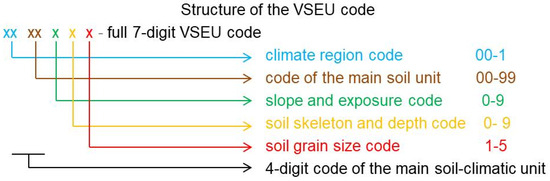
Figure 6.
The structure of the VSEU code [35].
Our approach was based on synthetic–parametric method [35], which was developed on the basis of a separate evaluation of the influence of seven soil ecological factors on crop yields and subsequent calculation according to the following formula:
where the soil fertility is expressed as a soil production potential (SPP) that is a function of the main soil unit (SJ), slope steepness and aspect (SA), skeletal content and depth (SD), grain size distribution (G) and climate factor (K) on a scale ranging from 0 to 100 (0 for non-productive soils, and 100 for the most fertile soils) that we have adjusted and rescaled into 10 categories (1—very low potential; 10—very high potential). Overall, there were 3000 individual VSEUs identified in the area of interest. By eliminating repetitive VSEUs, we evaluated 72 subtypes and, based on similarity parameters, they were further aggregated into 40 soil subtypes (Figure 7). All data were processes using the ESRI ArcGIS software 10.3.
SPP = K (SJ + SA + SD + G),
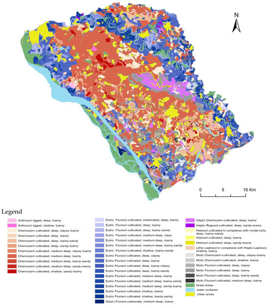
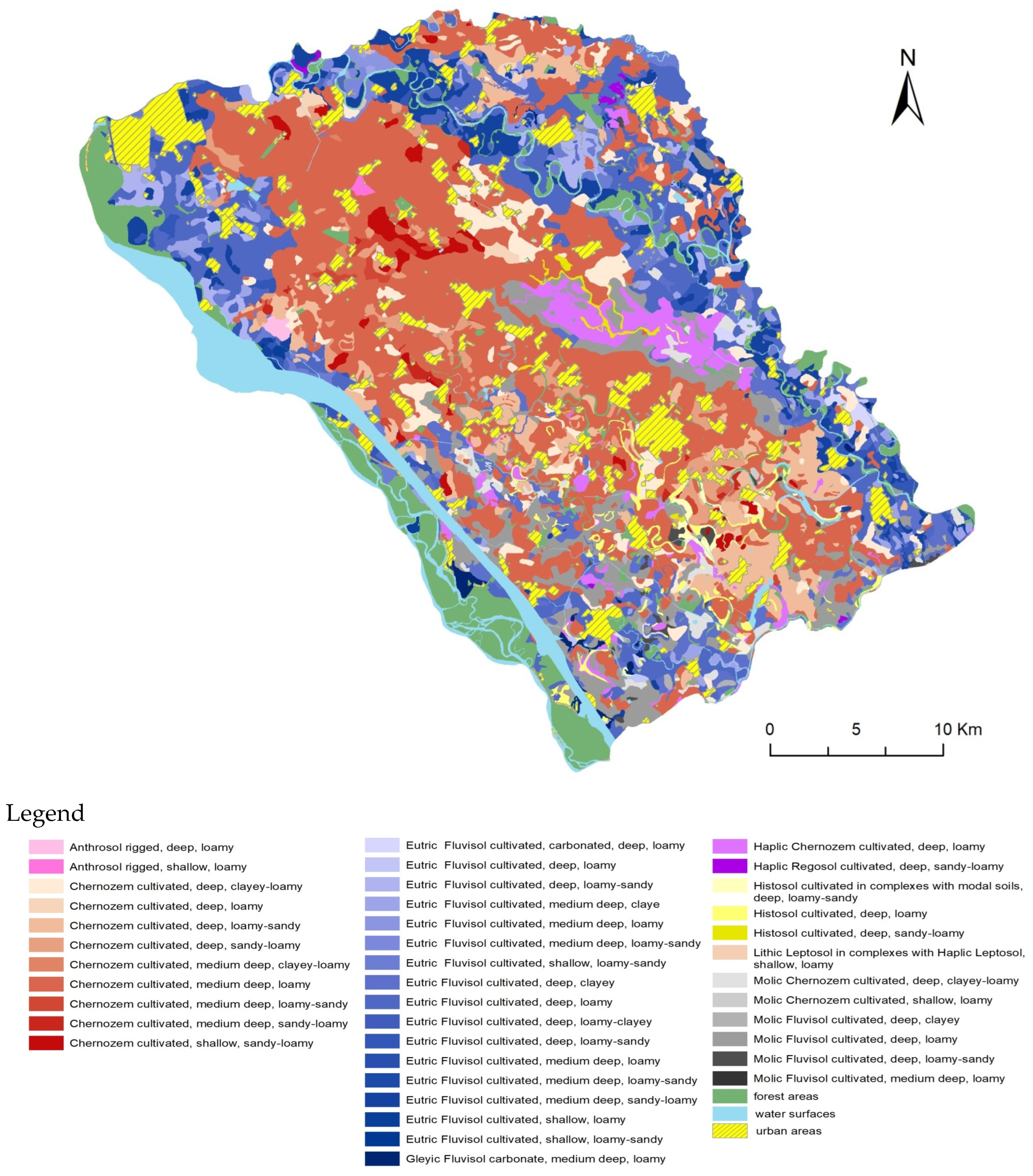
Figure 7.
Soil subtypes of the Protected Water Management Area Žitný Ostrov.
As a result, a map of soil subtypes of the Protected Water Management Area Žitný Ostrov (Figure 7) and a map of the spatial representation of the provision of SES (Figure 8) were processed.
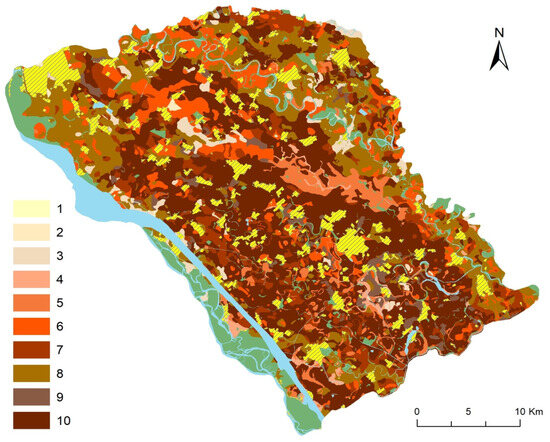
Figure 8.
Spatial representation of the potential for provision of supply (production) SES. Legend: 1—very low potential; 10—very high potential.
On the basis of the adapted procedures and methodologies described above, we then defined zones for landscape protection and revitalization, economic use, and non-productive land use on the basis of the selected supporting (productive) SES. The resulting map of proposals for the use of soil habitats in the Protected Water Management Area Žitný Ostrov was processed.
Selected SES can be measured directly, or we can derive their potential via modeling. We are aware that there are numerous other (and equally important) functions, which we did not include in our analyses. Their evaluation can be the subject of further research, after standardizing the methodological approaches.
3. Results and Discussion
3.1. Characteristics of Soil Conditions
Žitný Ostrov is characterized by a vast alluvial plain with the prevalence of semihydromorphic and hydromorphic soils. Based on the hydrological–morphological criteria, this area can be divided into two sub-regions. The first, larger sub-region covers the eastern part of the Podunajská rovina lowland, and it is characterized by three types of soils that have been formed here under the influence of groundwater and floods. Various subtypes of fluvisols are prevalent. In some places, they were transformed into mollic fluvisols. In the lower parts of the alluvial plain, between aggradation embankments, where the groundwater is closer to the surface, we can find gleyic mollic fluvisols. Along the edges of aggradation embankments, where the groundwater is deeper, mollic fluvisols occur. The ridges of aggradation embankments, where the groundwater is the deepest, are characterized by the presence of mollic fluvisols and carbonated mollic fluvisols. On the floodplains along the rivers, wide strips of carbonated mollic fluvisols are also present. Žitný Ostrov between Bratislava and Dunajská Streda is also covered by mollic fluvisols and carbonated mollic fluvisols. The remaining parts of Žitný Ostrov are covered by mollic fluvisols with accompanying patches of gleyic mollic fluvisols. The formations ofeolian sands is characterized by the presence of haplic regosols [36]. Despite the fact that in the past, saline soils covered a relatively large proportion of the Podunajská nížina lowland (approximately 8300 ha) [37], the present remnants cover an area of 500 ha [36], more or less, which is negatively impacted by human activity. Over the decades, the extent of all plant communities bound to saline soils has been lowered by human activity.
The representation of soil subtypes that can be found in the model area of the Protected Water Management Area Žitný Ostrov is shown on Figure 7.
In Table 1, we provide an example of a detailed breakdown of VSEU parameters and the value of the selected supply (production) SES, which served as a basis for elaborating the map of spatial representation of the potential for the provision of selected supply SES (Figure 8).

Table 1.
Example of the evaluation of VSEU parameters of the selected supple (production) soil ecosystem service.
3.2. Proposal for Spatial Representation of Multifunctional Use of the Model Area
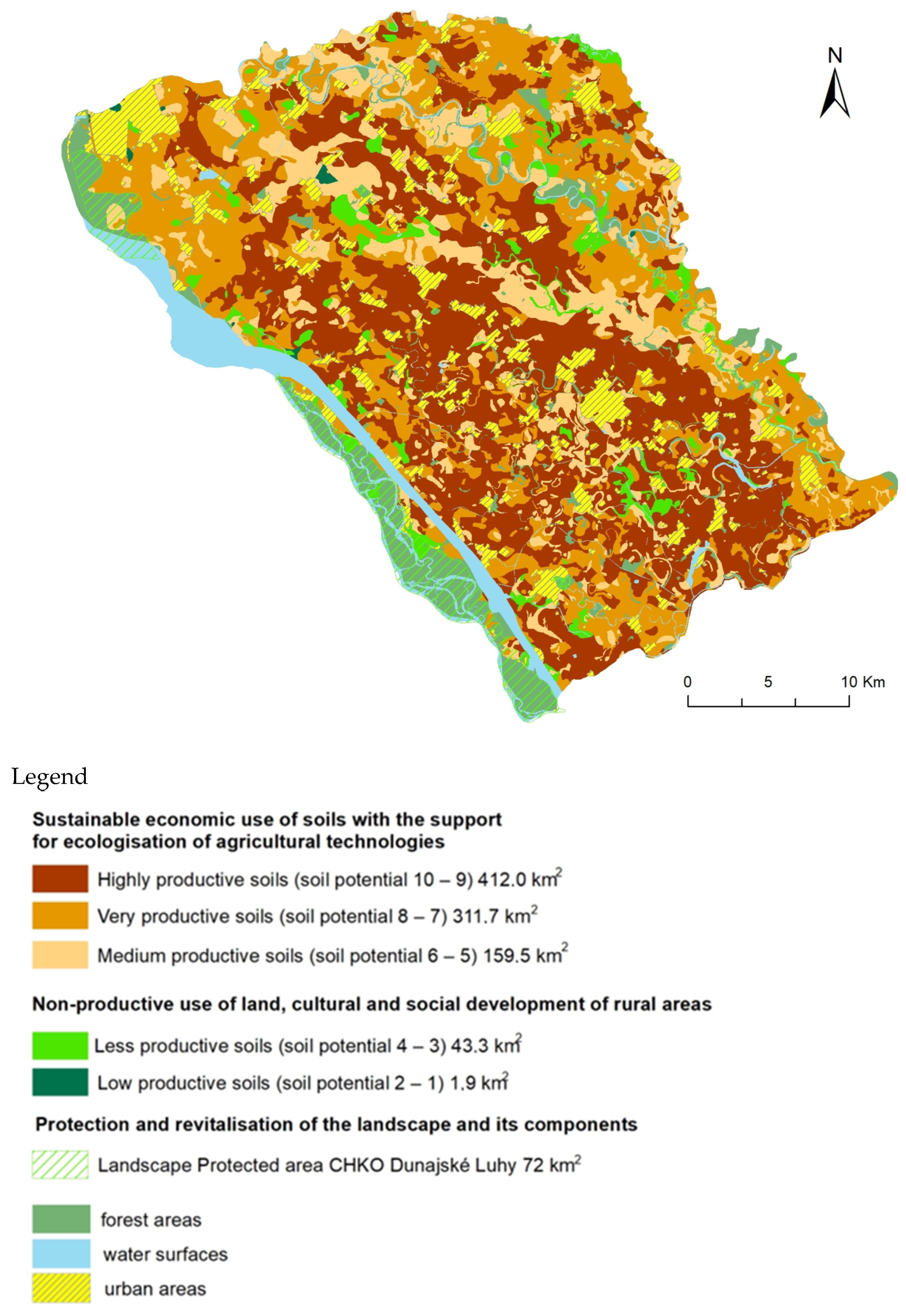
From the perspective of addressing the practical issues of soil protection, it is important to emphasize that the priority in the Protected Water Management Area Žitný Ostrov is the protection of groundwater that is superior to the economic efficiency of crop cultivation. According to soil potential and taking into account the climate data, we propose multifunctional use of the model area that includes the sustainable economic use of soils with the support for the ecologization of agricultural technologies, non-productive use of land, cultural and social development of rural areas, and protection and revitalization of the landscape and its components (Figure 9).

Figure 9.
Proposal for the use of soil habitats in the Protected Water Management Area Žitný Ostrov.
3.2.1. Sustainable Economic Use of Soils with Support for the Ecologization of Agricultural Technologies
In recent decades, Slovakia has been affected several times by extreme local climate changes (drought, floods, and windstorms), which have had a negative impact on the stability of the natural ecosystems [38].
The adapting measures that can bring stable and high crop yields are as follows: proper crop rotation, cropping practice, suitably selected regenerative (no-till) soil cultivation techniques, minimal inputs, suitable fertilization, and suitably selected management, which takes into consideration regulation, disease, weed, and pests’ control, which are aimed at the preservation and regeneration of the SOC amount in the soil [39,40]. Organic fertilization or the use of organic mulch (e.g., straw mulch) have the same result as reducing inputs for soil cultivation. Irrigation can be used as well; however, it often represents a significantly costly aspect of agriculture [41,42].
It is important to state that the agroecosystems in the model area represent large-scale fields, where it is essential to reduce the size of field parcels and implement the linear elements of woody vegetation within the regional territorial system of ecological stability (RTSES).
- Highly productive soils (soil potential 10–9) 412 km2.
The area of the Podunajská nížina lowland, with highly productive soils, is suitable for grain cultivation, mainly winter wheat (Triticum aestivum L.), corn (Zea mays L.), sunflower (Helianthus annuus L.), and more [43]. However, it is technologically demanding and requires high energy inputs. The solution is to leave as much of the crop biomass as possible without subsequent autumn ploughing and to leave the crop residue to decompose naturally. In the system of regenerative agriculture, no-till cultivation and strip-still cultivations are used, which are suitable for row crops (corn, sunflower, and others). Sunflower cultivation is always developing hand in hand with the development of new cultivation technology, the development of new varieties, and processing of this promising oil crop.
Growing fruit and leafy vegetables is a suitable choice. For the sustainable development of vegetable farming, we prefer the use of organic fertilizers (farmyard manure, compost, green fertilizer, Lignofert, Perlit, substrates based on soil and sand, bark and wood products, fallen leaves, and many others) with good granularity (mildly heavy). It is crucial to know which vegetables do not require or do not tolerate direct farmyard manure application.
A certain solution in the context of global warming is the construction of large-capacity greenhouses, where a suitable microclimate and irrigation could be maintained using the latest eco-friendly technology with the supply of the necessary nutrients.
- Very productive soils (soil potential 8–7) 311.7 km2.
Fruit orchards, mainly apple (Malus domestica Borkh.), apricot (Prunus armeniaca L.), and peach (Prunus persica (L.) Batsch) trees are suitable, as they belong to very tolerant fruit species with the highest number of varieties, which is taken into consideration when determining their suitability for cultivation within the agricultural soils of Slovakia. Modern cultivars are more demanding in terms of soil quality, which is connected to earlier fruiting and high annual fruit yields. As far as soil types are concerned, the most suitable are chernozems, cutanic luvisols, haplic cambisols, and haplic fluvisols.
The ban on chemical pesticides and GMOs in organic farming restricts the tools available to farmers for effective weed, insect pests, and plant disease control. That is why in the environments with high pest pressure and in places with pests and diseases that are difficult to control using biological methods, yield gaps in organic farming are higher than in environments with low pest pressure.
- Medium productive soils (soil potential 6–5) 159.5 km2.
A suitable use of less productive soils with good moisture conditions is the cultivation of warm-season legume species such as common bean (Phaseolus vulgaris L., soybean (Glycine max (L.) Merrill.), which is, however, very demanding in terms of moisture conditions. When determining the suitability of a species based on the ecological conditions of the site, we also take into consideration the production area, the soil type, moisture conditions, and the nutrient content of the soil. That is why the moderately heavy types of haplic fluvisols are suitable.
From the perspective of Slovak agriculture, it is important to consider biomass as a crucial means that enables an increase in the competitiveness of agricultural sector products, while it synergically addresses the important areas of the national economy, such as reducing unemployment, countryside revitalization, sustainable development, or improving the quality of the environment [44].
Another possibility to increase and improve production is the use of intergeneric hybrids in the grass assortment. Together with tetraploid clover varieties (Trifolium pratense L.), they contribute to more reliable fodder plant production with a higher carbohydrate content compared to the predominant production of fodder from grasslands. Grasses and clover grasses of this type can fully replace traditional pure clover crops; they will ameliorate the protein-to-carbohydrate ratio in animal feed ratios during the winter, and while dealing with weeding without herbicides the best, they significantly reduce the erosion processes [45]. Another example is reforestation or the restoration of grassy covers on a former field, which can reduce the carbon deficit caused by years of agricultural production and help carbon sequestration through higher root productivity when compared to crops [27].
3.2.2. Non-Productive Use of Land, and Cultural and Social Development of Rural Areas
- Less productive soils (soil potential 4–3) 43.3 km2.
Soil that is not used for growing crops for food purposes should be prioritized for growing crops for energy purposes. In accordance with the impoverishment of our agriculture, it is recommended not only to reforest the less suitable soils for crop cultivation, or those currently used only as lower-quality meadows and pastures [46], but also to plant and cultivate fast-growing woody plants, which can at the same time serve as biocentres and biocorridors for eco-stabilization land effects [47]. These soils should be used to improve the overall ecosystem stability around watercourses and water bodies, around fields, along roads, and near settlements in the form of the following:
- -
- Grass cover, which will help water retention in the landscape, increase biodiversity and overall soil amelioration, surface water, and groundwater quality in this area.
- -
- Planting groves, which will contribute to slope stabilization, a reduction in the risk of erosion by water or wind, mitigation of transport emissions effect, protection from wind and dust, improving the quality of water and soil, improvement to the microclimate, increased biodiversity, and, last but not least, aesthetic function.
In areas with waterlogged soils, various species of native willows can be planted: Salix alba L., Salix fragilis L., or Salix caprea L. Woody plants are best suited for pseudogleyic and gleyic soil types and subtypes: pseudogleyic, gleyic, gleyic mollic fluvisol, mainly haplic gleyic fluvisol, as they can be planted in river basins of streams and rivers. For fast-growing woody plants, moisture-tolerant trees are suitable [48]. Native species of Populus alba L., or Populus deltoids L., but mostly cultivated species of Euro-American poplars, such as Populus canadensis MOENCH are more suitable for lowland areas. This way, we expect to reduce pressure on the landscape and increase its biodiversity [49].
Benefits of fast-growing woody plants are as follows:
- -
- The use of lower-quality soils (preserving or improving soil quality through strengthening the humus layer via extensive soil management).
- -
- Improvement to the air quality thanks to dust filtration by leaves (positive impact on climate by storing additional carbon in trunks, roots, leaves, and soil).
- -
- Reduction in burden using machinery (entering the new area, which has a future thanks to economic advantages and environment protection).
- -
- Safe and reliable income, which does not depend on the weather.
- -
- Reduction in greenhouse gasses through carbon sequestration, which positively affects the regulatory ecosystem service of the environment [50,51,52].
An effective tool for diversifying agricultural activities and promoting non-productive functions is agro-tourism, which can become an important source of income in addition to that generated by the farmer’s productive activities. Changing and enriching the landscape structure in the areas farmed (planting new tree plantations, alleys, dividing strips, flowering plant strips, the maintenance of existing, and the creation of new hiking, cycling, and hippo paths, etc.), as well as demonstrations of traditional landscape management (hand mowing competitions and working with old agricultural machinery—steam engines, tractors, and threshing machines), the cultivation of old and regional varieties of agricultural crops, breeding of traditional breeds of livestock, or the organization of traditional festivals linked to land management (spring grazing, harvest festivals), can increase the attractiveness of the region for tourists and create jobs in local areas.
- Low productive soils (soil potential 1–2) 1.9 km2.
Soils with low production potential are predominantly gleyic subtype soils and Histosol that have been ploughed and used as arable land in the past. We propose to leave these to natural regeneration in order to start revitalization in the region and thus help restore the original ecosystems in the area, with an emphasis on those that are critical in mitigating the negative effects of climate change—wetlands and aquatic ecosystems. Another possible action aimed at restoring the original state of ecosystems in the area of Žitný Ostrov is the revitalization of watercourses using historical mapping data, which is a relevant basis for planning and decision-making processes in the agrarian landscape. On this basis, a relatively precise and detailed comparative analysis is possible to identify ecologically valuable and stable elements (biotopes) in the landscape (wetlands, periodic puddles, meanders of watercourses, riparian vegetation, etc.) in the past and the subsequent use of this knowledge in the creation of the local/regional territorial system of ecological stability.
3.2.3. Protection and Revitalization of the Landscape and Its Components
Agriculture does not only fulfill a primary (productive) function but also a number of non-productive functions, including nature conservation, landscape protection, and biodiversity conservation in the cultural landscape. From the existing and practically verified measures, we have selected those that are possible to implement in the study area and through which it is possible to achieve the maximum environmental effect and biodiversity protection.
A mixed agricultural–forest landscape composed of mosaics of arable land, meadows, orchards, pastures, and forest vegetation in various site conditions should create transitional zones between agricultural and forest landscapes [53]. It is a buffer zone between agroecosystems, natural ecosystems, and protected areas.
Within the model area, the largest protected area is the PLA (Protected Landscape Area) Dunajské Luhy (72 km2), which is located along the Slovak and Slovak–Hungarian part of the river Danube from Bratislava to Island Veľký Lél in the Komárno district. The channel system has been partly preserved in the section from Dobrohošť to Sap, and it belongs to the largest inland river deltas in Europe. The PLA Dunajské Luhy is also a significant international bird area (IBA). Depending on the hydrological conditions along the river Danube, there are various forest, aquatic, wetland, meadow, and psammophile communities present in a relatively small area. These sites also serve as biocenters and biocorridors of the local territorial system of ecological stability (LTSES) in the Protected Water Management Area Žitný Ostrov [54].
They represent biocenters (ecosystems) or groups of ecosystems that create permanent conditions for the reproduction, shelter, and nourishment of living organisms and the preservation and natural development of their communities. Biocorridors (channel systems of the river Danube and other river systems) represent a spatially connected set of ecosystems that connect biocenters and facilitate the migration and exchange of genetic information among living organisms and their communities, to which interactive elements connect. The whole area of the PLA is on the List of Wetlands of International Importance (Ramsar Convention on Wetlands).
The construction of the Gapčíkovo dam destroyed or negatively affected most of the 230 km2 of wetlands and directly disrupted the original and unique ecosystem along a 37 km long river stretch [55]. It has led to changes in the original composition of plants and animal communities and slow degradation of the riparian floodplain forests due to the reduced amount of floodwater entering the channel systems of wetland ecosystems. The current artificial flooding system cannot fully replace previous natural floods in the Danube inland delta, and it is also insufficient for the restoration and preservation of the optimal moisture conditions in the softwood floodplain forests, which would be similar to the pre-operation period of the Gabčíkovo Waterworks [56]. Currently, research, restoration, and management of biotopes are being addressed by several research institutions and conservation associations, for example, through LIFE Restoration and Management of Biotopes projects.
4. Conclusions
In our study, we selected a model area to be a very vulnerable type of landscape, where highly productive soils are present together with large groundwater resources, the preservation of which is economically superior to the provisioning soil ecosystem services. In the presented study, based on a detailed soil information database (VSEU), we were able to evaluate and quantify the selected SES. Based on the knowledge of the detailed spatial variability of soil parameters in the study area, we proposed three zones of multifunctional use with the use of soft forms of ecological and regenerative management.
Author Contributions
Conceptualization, Z.K.; methodology, Z.K.; software and validation, Z.K.; investigation, Z.K., P.K. and Z.B.; formal analysis, Z.K., P.K. and Z.B.; resources, Z.K., P.K., Z.B. and M.B.; data curation, P.K. and Z.K.; writing—original draft preparation, Z.K., Z.B. and M.L.; writing—review and editing, Z.K., Z.B. and M.B.; visualization, P.K.; supervision, Z.K., Z.B. and M.B. All authors have read and agreed to the published version of the manuscript.
Funding
The case study was prepared within solving the project VEGA No. 2/0015/24 Multi-criteria approach of sustainable multifunctional use of highly vulnerable area determination and VEGA No. 2/0135/22 Research of specific landscape elements of bio-cultural landscape in Slovakia, funded by the Scientific Grant Agency of the Slovak Ministry of Education, Science, and Sport and the Slovak Academy of Sciences (SAV).
Institutional Review Board Statement
Not applicable.
Informed Consent Statement
Not applicable.
Data Availability Statement
All data included in the main text.
Conflicts of Interest
The authors declare no conflicts of interest.
References
- Rodrigues, A.F.; Latawiec, B.J.; Reid, B.J.; Solórzano, A.; Schuler, A.E.; Lacerda, C.; Fidalgo, E.C.C.; Scarano, F.R.; Tubenchlak, F.; Pena, I.; et al. Systematic review of soil ecosystem services in tropical regions. R. Soc. Open Sci. 2021, 8, 201584. [Google Scholar] [CrossRef] [PubMed]
- AbdelRahman, M.A.E.; Shalaby, A.; Aboelsoud, M.H.; Moghanm, F.S. GIS spatial model based for determining actual land degradation status in Kafr El-Sheikh Governorate, North Nile Delta. Model. Earth Syst. Environ. 2018, 4, 359–372. [Google Scholar] [CrossRef]
- Bennett, E.M.; Peterson, G.D.; Gordon, L.J. Understanding relationships among multiple ecosystem services. Ecol. Lett. 2009, 12, 1394–1404. [Google Scholar] [CrossRef] [PubMed]
- Bommarco, R.; Kleijn, D.; Potts, S.G. Ecological intensification: Harnessing ecosystem services for food security. Trends Ecol. Evol. 2013, 8, 230–238. [Google Scholar] [CrossRef] [PubMed]
- Tóth, G.; Gardi, C.; Bódis, K.; Ivits, É.; Aksoy, E.; Jones, A.; Jeffrey, S.; Petursdottir, T.; Montanarellaet, L. Continental-scale assessment of provisioning soil functions in Europe. Ecol. Process. 2013, 2, 32. [Google Scholar] [CrossRef]
- Dominati, E.; Patterson, M.; Mackay, A. A framework for classifying and quantifying the natural capital and ecosystem services of soils. Ecol. Econ. 2010, 69, 1858–1868. [Google Scholar] [CrossRef]
- Ramzan, S.; Wani, M.; Bhat, M. Assessment of Spatial Variability of Soil Fertility Parameters Using Geospatial Techniques in Temperate Himalayas. Int. J. Geosci. 2017, 8, 1251–1263. [Google Scholar] [CrossRef]
- Malla, R.; Shrestha, S.; Khadka, D. Soil Fertility Mapping and Assessment of the Spatial Distribution of Sarlahi District, Nepal. Am. J. Agric. Sci. 2020, 7, 8–16. [Google Scholar]
- Lelago, A.; Mamo, T.; Haile, W.; Shiferaw, H. Assessment and mapping of status and spatial distribution of soil macronutrients in kambata tembaro zone, southern Ethiopia. Adv. Plants Agric. Res. 2016, 4, 305–317. [Google Scholar] [CrossRef]
- Panday, D.; Ojha, R.B.; Chalise, D.; Das, S.; Twanabasu, B. Spatial variability of soil properties under different land use in the Dang district of Nepal. Cogent Food Agric. 2019, 5, 1600460. [Google Scholar] [CrossRef]
- Tagore, G.S.; Bairagi, G.D.; Sharma, R.; Verma, P.K. Spatial variability of soil nutrients using geospatial techniques: A case study in soils of sanwer tehsil of indore district of Madhya Pradesh. Int. Arch. Photogramm. Remote Sens. Spat. Inf. Sci. 2014, 40, 1353–1363. [Google Scholar] [CrossRef]
- Çakmakçı, R.; Salik, M.A.; Çakmakçı, S. Assessment and Principles of Environmentally Sustainable Food and Agriculture Systems. Agriculture 2023, 13, 1073. [Google Scholar] [CrossRef]
- Benbi, D.K.; Brar, K.; Toor, A.S.; Singh, P. Total and labile pools of soil organic carbon in cultivated and undisturbed soils in northern India. Goederma 2015, 237, 149–158. [Google Scholar] [CrossRef]
- Yadav, G.S.; Das, A.; Lal, R.; Babu, S.; Meena, R.S.; Saha, P.; Singh, R.; Datta, M. Energy budget and carbon footprint in a no-till and mulch-based rice–mustard cropping system. J. Clean. Prod. 2018, 191, 144–157. [Google Scholar] [CrossRef]
- Lal, R. Digging deeper: A holistic perspective of factors affecting soil organic carbon sequestration in agroecosystems. Glob. Chang. Boil. 2018, 24, 3285–3301. [Google Scholar] [CrossRef]
- Zhang, X.W.; Han, X.Z.; Yu, W.T.; Wang, P.; Cheng, W.X. Priming effects on labile and stable soil organic carbon decomposition: Pulse dynamics over two years. PLoS ONE 2017, 12, e0184978. [Google Scholar] [CrossRef]
- Addiscott, T. Entropy and sustainability. Eur. J. Soil Sci. 1995, 46, 161–168. [Google Scholar] [CrossRef]
- Blair, N.; Crocker, G.J. Crop rotation effects on soil carbon and physical fertility of two Australian soils. Aust. J. Soil Res. 2000, 38, 71–84. [Google Scholar] [CrossRef]
- Blair, G.J.; Lefroy, R.D.B.; Lisle, L. Soil carbon fractions and their degree of oxidation and the development of a carbon management index for agricultural systems. Aust. J. Agric. Res. 1995, 46, 1459–1466. [Google Scholar] [CrossRef]
- Blair, N.; Faulkner, R.D.; Till, A.R.; Korschens, M.; Schulz, E. Long-term management impacts on soil C, N and physical fertility. Part II. Bad Lauchstadt static and extreme FYM experiments. Soil Tillage Res. 2006, 91, 39–47. [Google Scholar] [CrossRef]
- Blair, N.; Faulkner, R.D.; Till, A.R.; Crocker, G.J. Long-term management impacts on soil C, N and physical fertility. Part III. Tamworth crop rotation experiment. Soil Tillage Res. 2006, 91, 48–56. [Google Scholar] [CrossRef]
- Diekow, J.; Mielniczuk, J.; Knicker, H.; Bayer, C.; Dick, D.P.; Kogel-Knaber, I. Carbon and nitrogen stocks in physical fractions of a subtropical Acrisol as influenced by long-term no-till cropping systems and N fertilization. Plant Soil 2005, 268, 319–328. [Google Scholar] [CrossRef]
- Ontl, T.A.; Schulte, L.A. Soil Carbon Storage. Nat. Educ. Knowl. 2012, 3, 35. [Google Scholar]
- Sasaki, K.; Hotes, S.; Ichinose, T.; Doko, T.; Wolters, V. Hotspots of Agricultural Ecosystem Services and Farmland Biodiversity Overlap with Areas at Risk of Land Abandonment in Japan. Land 2021, 10, 1031. [Google Scholar] [CrossRef]
- Früh-Müller, A.; Hotes, S.; Breuer, L.; Wolters, V.; Koellner, T. Regional patterns of ecosystem services in cultural landscapes. Land 2016, 5, 17. [Google Scholar] [CrossRef]
- Konvalina, P.; Moudrý, J.; Moudrý, J.J.; Kalinová, J. Pěstování Rostlin v Ekologickém Zemědělství; Jihočeská univerzita v Českých Budějovicích Zemědělská Fakulta: České Budějovice, Czech Republic, 2007; 132p. (In Czech)
- Oelkers, E.H.; Cole, D.R. Carbon Dioxide Sequestration A Solution to a Global Problem. Elements 2008, 4, 305–310. [Google Scholar] [CrossRef]
- Seufert, V.; Ramankutty, N.; Foley, J. Comparing the yields of organic and conventional agriculture. Nature 2012, 485, 229–232. [Google Scholar] [CrossRef]
- Gomiero, T.; Pimentel, D.; Paoletti, M.G. Environmental Impact of Different Agricultural Management Practices: Conventional vs. Organic Agriculture. Crit. Rev. Plant Sci. 2011, 30, 95–124. [Google Scholar] [CrossRef]
- Niggli, U. Sustainability of organic food production: Challenges and innovations. Proc. Nutr. Soc. 2015, 74, 83–88. [Google Scholar] [CrossRef]
- Seufert, V.; Ramankutty, N. Many shades of gray—The context-dependent performance of organic agriculture. Sci. Adv. 2017, 3, e1602638. [Google Scholar] [CrossRef]
- MŽP SR (Ministry of Environment of the Slovak Republic). Správa o Hodnotení Strategického Dokumentu Program Rozvoja Vidieka SR na Programovacie Obdobie 2014–2020; MŽP SR (Ministry of Environment of the Slovak Republic): Bratislava, Slovakia, 2022. (In Slovak)
- SHMI (Slovak Hydrometeorological Institute). Klimatologické Dáta z Lokalít VD Gabčíkovo, Hurbanovo, Bratislava—Letisko; SHMI (Slovak Hydrometeorological Institute): Bratislava, Slovakia, 2023. (In Slovak)
- NPPC (National Agriculture and Food Centre). Database of Soil-Ecological Units (QSEU) Slovakia. Scale 1:10,000; NPPC: Lužianky, Slovakia, 2021. (In Slovak) [Google Scholar]
- Džatko, M.; Sobocká, J.; Granec, M.; Bezák, P. Inovovaná Príručka pre Používanie Máp Pôdnoekologických Jednotiek; VÚPOP: Bratislava, Slovakia, 2009. (In Slovak)
- Sádovský, M.; Eliáš, P.J.; Dítě, D. Historické a súčasné rozšírenie slaniskových spoločenstiev na juhozápadnom Slovensku. Bull. Slov. Bot. Spoločn. 2004, 26, 127–129. (In Slovak) [Google Scholar]
- Osvačilová, V.; Svobodová, Z. Floristicko-Fytocenologický Prieskum Nitrianskeho Kraja (Tématická Mapa); VŠP: Nitra, Slovakia, 1961; 10p. (In Slovak) [Google Scholar]
- Špánik, F.; Šiška, B.; Tomlain, J.; Repa, Š. Ukazovatele Agroklimatickej Rajonizácie Poľnohospodárskej Výroby na Slovensku v Podmienkach Klimatickej Zmeny; Štúdia SBKS SAV XVII; roč.15; Slovenská poľnohospodárska univerzita: Nitra, Slovakia, 2001; 54p. (In Slovak)
- Freibauer, A.; Rounsevell, M.D.A.; Smith, P.; Verhagen, J. Carbon sequestration in the agricultural soils of Europe. Geoderma 2004, 122, 1–23. [Google Scholar] [CrossRef]
- Thompson, J.A.; Kolka, R.K. Soil carbon storage estimation in central hardwood forest watersheds using quantitative soil-landscape modeling. Soil Sci. Soc. Am. J. 2005, 69, 1086–1093. [Google Scholar] [CrossRef]
- Plentinger, M.C.; de Vries, F.P. Rotation Models for Ecological Farming; CAMASE/PE Workshop Report (No. 10); Research Institute for Agrobiology and Soil Fertility: Wageningen, The Netherlands, 1997; AB-DLO.
- Garbach, K.; Lubell, M.; DeClerck, F.A. Payment for ecosystem services: The roles of positive incentives and information sharing in stimulating adoption of silvopastoral conservation practices. Agric. Ecosyst. Environ. 2012, 156, 27–36. [Google Scholar] [CrossRef]
- Vilček, F. Potenciál pôd agrárnej krajiny na pestovanie obilnín. Geogr. Časopis 2009, 61, 153–163. (In Slovak) [Google Scholar]
- Kološta, S.; Flaška, F. Biomass local production systems and their managing: Alternative to rural development in Slovakia. Folia Oeconomica 2016, 2, 23–40. [Google Scholar] [CrossRef]
- Ilavská, Z.I.; Hanzes, Ľ.; Bitaňák, N. Udržiavanie revitalizovaných TTP v krmovinárskom prijateľnom stave. Naše Pole 2023, 8, 26–29. (In Slovak) [Google Scholar]
- Smith, P.; Martino, D.; Cai, Z.; Gwary, D.; Janzen, H.; Kumar, P.; McCarl, B.; Ogle, S.; McCarl, B.; O’Mara, F.; et al. Greenhouse gas mitigation in agriculture. Phil. Trans. R. Soc. B Biol. Sci. 2007, 363, 789–813. [Google Scholar] [CrossRef]
- Vilček, J.; Hronec, O.; Huttmanová, E.; Haviar, L. Bioenergetický potenciál poľnohospodárskych pôd Slovenska. In Multiplikačný Efekt Využitia Biomasy v Regionálnom Rozvoji; VVICB: Kapušany pri Prešove, Slovakia, 2012; pp. 5–11. (In Slovak) [Google Scholar]
- Khadka, D.; Lamichhane, S.; Bhantana, P.R.; Bhantana, P.; Ansari, A.R.; Joshi, S.; Baruwal, P. Soil fertility assessment and mapping of chungbang farm, Pakhribas, Dhankuta, Nepal. Adv. Plants Agric. Res. 2018, 8, 219–227. [Google Scholar] [CrossRef]
- Vilček, J. Možnosti a riziká zhodnocovania potenciálu poľnohospodárskej pôdy pomocou energetických plodín. In Obnoviteľné Zdroje Surovín—Šanca Pre Znevýhodnené Regióny; EU v Bratislave: Bratislava, Slovakia, 2006; pp. 46–57. (In Slovak) [Google Scholar]
- Burkhard, B.; Kroll, F.; Nedkov, S.; Müller, F. Mapping ecosystem service supply, demand and budgets. Ecol. Indic. 2012, 21, 17–29. [Google Scholar] [CrossRef]
- Makovníková, J.; Pálka, B.; Kološta, S.; Flaška, F. Potenciál pre pestovanie energetických plodín—Obnoviteľného zdroja energie vo vybraných regiónoch Slovenska. In Medzinárodné Kolokvium o Regionálních Vědách; Sborník Příspevku: Brno, Czech Republic, 2020; (In Slovak). [Google Scholar] [CrossRef]
- Kanianska, R.; Jaďuďová, J.; Makovníková, J.; Kizeková, M. Assessment of Relationships between Earthworms and Soil Abiotic and Biotic Factors as a Tool in Sustainable Agricultural. Sustainability 2016, 8, 906. [Google Scholar] [CrossRef]
- Bezák, P.; Izakovičová, Z.; Miklós, L. Reprezentatívne Typy Krajiny Slovenska; ÚKE SAV: Bratislava, Slovakia, 2010; 179p. (In Slovak)
- Enviroportál. Správa o Hodnotení Strategického Dokumentu Program Rozvoja Vidieka SR na Programovacie Obdobie 2014—2020, III. Základné Údaje o Súčasnom Stave Životného Prostredia Dotknutého Územia. 2021. Available online: https://www.enviroportal.sk/sk/eia/detail/program-rozvoja-vidieka-sr-na-programovacie-obdobie-2014-2020 (accessed on 15 September 2023). (In Slovak)
- Čejka, T.; Beracko, P.; Matečný, I. The impact of the Gabčíkovo hydroelectric power barrier on the Danube floodplain environment—The results of long-term monitoring of land snail fauna. Environ. Monit. Assess. 2020, 192, 30. [Google Scholar] [CrossRef] [PubMed]
- Šibíková, M.; Matečný, I.; Uherčíková, E.; Pišút, P.; Kubalova, S.; Valachovič, M.; Hodálová, I.; Mereďa, P.; Bisbing, S.; Medvecká, J. Effect of the Gabčíkovo Waterworks (Slovakia) on riparian floodplain forest ecosystems in the Danube inland delta: Vegetation dynamics and trends. Biologia 2017, 72, 722–734. [Google Scholar] [CrossRef]


Disclaimer/Publisher’s Note: The statements, opinions and data contained in all publications are solely those of the individual author(s) and contributor(s) and not of MDPI and/or the editor(s). MDPI and/or the editor(s) disclaim responsibility for any injury to people or property resulting from any ideas, methods, instructions or products referred to in the content. |
© 2023 by the authors. Licensee MDPI, Basel, Switzerland. This article is an open access article distributed under the terms and conditions of the Creative Commons Attribution (CC BY) license (https://creativecommons.org/licenses/by/4.0/).