Abstract
Greening the unused or inefficient land surface is of vital importance to increase the carbon pool in environmentally fragile but depopulated rural areas. A proactive land-use strategy, rural residential land decrement (RRLD), is triggered by rural land abandonment and can contribute to greening the land surface. A RRLD can be designed and implemented according to the specific regulations and rules and linked to regional environmental change. However, the carbon consequences of implementing multi-scenario RRLDs remain unknown. Thus, this study exemplifies a rural county of China, proposes a framework that illustrates how spatial zoning, decision model, and prediction techniques jointly determine the RRLD, and accounts for the associated carbon emissions under three scenarios. The results demonstrate that half of the 2012.23 hectares of RRLs were recommended for conversion to farming or gardening use. Under the scenarios of agricultural priority, compact ecological priority, and complete ecological priority, the change of carbon emission capacity in one township could be up to 77.41 tCO2 yr−1, −172.32 tCO2 yr−1, and −209.07 tCO2 yr−1. The total change of Fang’s carbon budget ranged from −1179.91 tCO2 yr−1 (sequestration) to 461.53 tCO2 yr−1 (emission). The findings provide a practical paradigm for utilizing land-use strategies to improve the carbon-related environment.
1. Introduction
During the past century, both the intensified urbanization and considerable land use and cover changes (LUCCs) have led to the imbalance of global CO2 cycles, causing an increase of 0.74 °C in the average global temperature, and probably an additional 1.5 °C in the next five years [1]. Human activities and consequent LUCCs become essential determinants of global environmental issues [2]. Land use impacts not only the terrestrial carbon sequestration by altering the ecosystem, but also the energy-related carbon emissions via LUCCs [3]. With a focus on carbon emissions as a connecting factor, recent studies have investigated the impacts of land use on terrestrial ecosystems [4,5,6]. Several studies have also estimated the LUCC-induced carbon emission budget using models that calculate the carbon density or emission (sequestration) capacity [7,8,9,10,11]. Apart from the efforts to control or reduce fossil energy consumption, both scholars and officials have begun to explore the ways to reach carbon emission mitigation goals from the perspective of land use [12,13].
An exploitation or encroachment of natural lands would result in a large amount of CO2 flow from terrestrial ecosystems to atmospheric ones; and conversely, encouraging the greening or CO2 fertilization activities on originally developed lands can reverse the flow of CO2 [14]. Due to the fact that an urban area is a main carbon emitter, and these keep expanding across the world, current policies favoring urbanization has forced policymakers to pay more attention to the tremendous carbon pool in rural areas [15]. Greening the rural land surface can offset the decline in local carbon sequestration [16].
Proximate causes linked to land use and its changes have altered the biogeochemical cycles in rural areas. Most rural virgin lands have once been severely disturbed by human activities, such as the expansion of rural residential land (RRL), resulting in a vegetation degeneration and the loss of carbon sink [17,18,19]. RRL plays a crucial role in the daily lives of rural residents and functions as a net carbon emitter [20]. In recent decades, most developing countries have undergone a tremendous rural change, witnessing the increasingly fierce RRL abandonment followed by continuous rural depopulation [21,22]. In response, rural areas require an adaptive allocation of vital natural resources, such as RRLs [23,24]. Theoretically, abandoned and inefficient RRL can be converted to other land types friendly to carbon sink, improving the total carbon budget in rural areas. However, the existing literature seldom links surplus RRL repurposing with the carbon budget.
Studies on identifying the RRLs vulnerable to inefficiency or abandonment have put forward various methods that evaluate the quantity of the specific RRLs [25,26]. However, none of them proposed the repurposing cases of those vulnerable lands. Meanwhile, an estimation of the effects of RRL repurposing on the carbon budget is based on the analyses of surplus RRL conversion, which should be arranged on the premise of mature land-use management, policies, and strategies. Rural residential land decrement (RRLD) is an anthropogenic process and a proactive strategy that determines which RRL parcels should convert from its original use to a more productive or ecological one, and which RRLs should retain their status quo. Processing the RRLD helps to coordinate the development and conservation [27,28,29,30].
In light of the literature review, the purposes of this study can be summarized into three aspects: First, it attempts to provide a conceptual framework that links the specific land use, namely surplus RRL repurposing, to the change in local carbon budgets. Second, it designs the principles and regulations of how a proactive RRLD should be processed, and exemplifies the process with the case study of a rural county in China. Third, it calculates and clarifies, under a complex regional context, how a typical environmental consequence (specifically pointing to the carbon emission change) could be like due to different RRLD scenarios. To be specific, a basic RRLD process was connected with spatial zoning and land-use planning, and the county’s carbon emission changes embodied in RRLD scenarios were analyzed. The case study on the changes in rural carbon budgets that resulted from different RRLD scenarios can provide references for the following: (1) the explorations to enhance the carbon pool in most depopulation areas, (2) the efforts to improve the carbon sequestration capacity by adjusting land-use structures in any corner of the world, and (3) similar studies on specific land decrement and its environmental consequence.
2. Materials and Methods
2.1. Study Area and Context
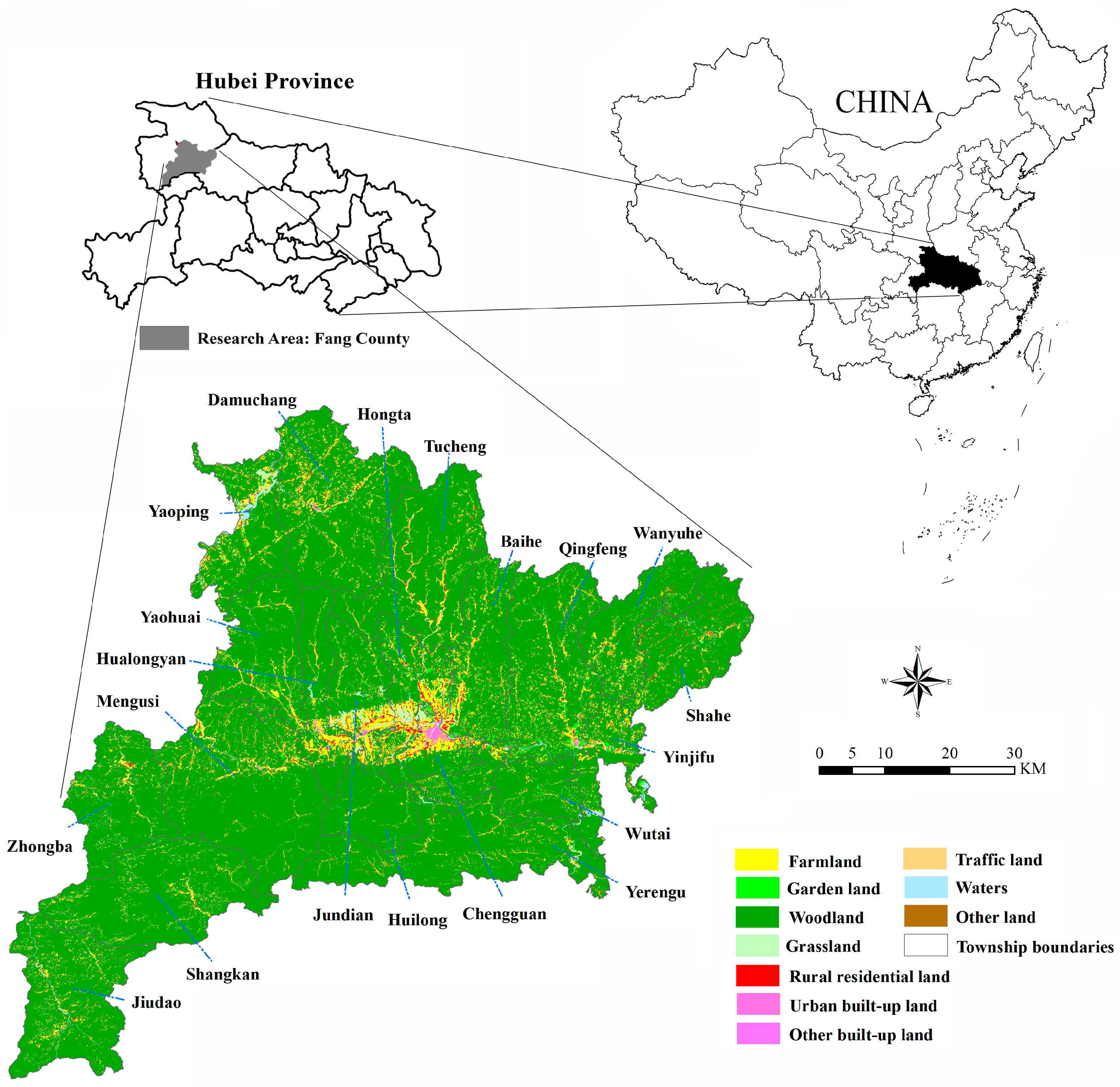
Fang County, a typical mountainous area, is situated in the southeastern corner of Shiyan City, Hubei Province, Central China (Figure 1). It has extreme geographical conditions and an elevation that rises more than 2200 m from the lowest point to the highest, with the slopes in the south being generally steeper than those in the north [31]. Adjacent to the northern urbanized area of Shiyan, Fang County experiences the spillover effects of social and economic changes of its neighbors. The desires to convert local rural lands to urban use are strong, and rural areas become more depopulated with time. Both natural and economic vulnerabilities limit the development of rural areas. Affected by the outbreak of COVID-19, a national lockdown, and economic fluctuations, the urbanization rate of Fang County in 2022 was less than 44%, an initial goal in land-use planning [32].
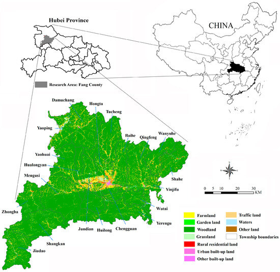
Figure 1.
Location and land-use map of Fang County.
In China, any land-use strategies should follow upper-level planning and policies, in which functional zone planning directs the territorial development, protection, and restoration process [33]. In fact, multiple land-use benefits derived from land-use planning and guidelines are well documented by Chinese scholars [34,35,36]. Relevant studies have also made significant progress in connecting the land-use reallocation with a spatial planning [37]. Therefore, the focuses of the case study should clarify how a RRLD coordinates with spatial planning and land-use limitations, and how different RRLD schemes achieve both agricultural and ecological goals.
2.2. Analytic Framework
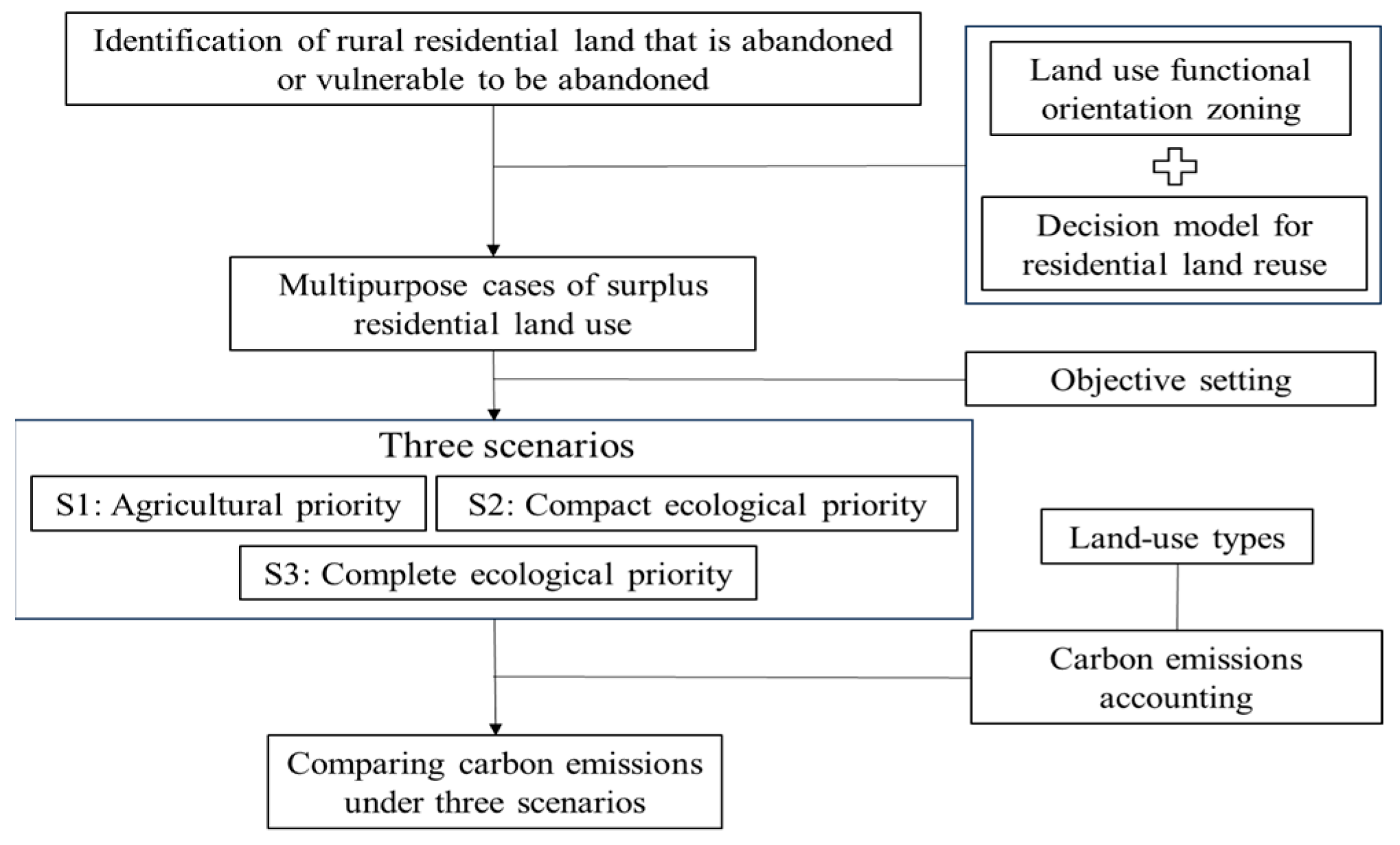
The RRLD and its carbon emission response were linked by proposing an analytic framework (Figure 2). First, RRLs that were abandoned or vulnerable to abandonment were identified. Second, a land-use function orientated zoning technique and a decision model were used to design the repurposing cases for RRLD. Third, a scenario analysis was used to predict the RRLD by setting up three different scenarios by 2025. Last, the changes in carbon emissions or the sequestration capacity under three scenarios were accounted for based on the carbon emission coefficient of different land-use types. Specifically, the three scenarios of RRLD include the following: S1 was defined as the agricultural priority, S2 was defined as a compact ecological priority, and S3 was defined as the complete ecological priority.
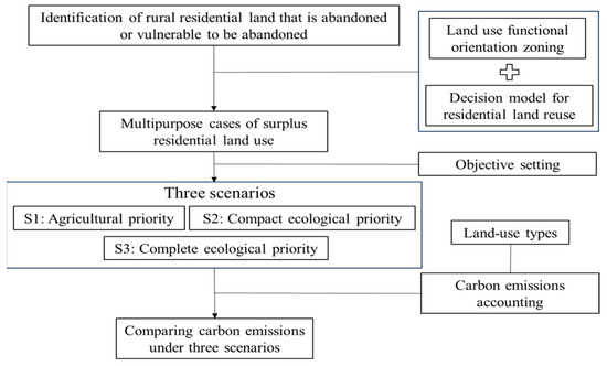
Figure 2.
A general framework that links RRLD to its carbon emission responses.
It should be noted that three criteria were proposed for a practical RRLD: First, the decisions about retaining and transferring how many and which RRL parcels are restricted by total quantity control and predictive preferences. Second, the repurposing case for each RRL parcel is determined by both land-use priorities and limitations. Third, a margin can be provided to accommodate the constructive expansion in the future. Thus, the use or repurposing cases of all original RRLs can be categorized into four situations: (1) to stabilize original residential use, (2) reserve as potential resources for future reuse, (3) convert to other ecological uses, and (4) replace other built-up lands spatially. The set scenarios were based on the different arrangements of the RRL repurposing.
2.3. Methods
2.3.1. Land-Use Function Orientated Zoning
- Indicator selection:
As a component of territorial spatial planning, main functional zoning identifies a range of existing and improved activities and guides the associated land use by determining which area or administrative unit has the greatest need for preserving its natural habitats, as well as where human activities should be more encouraged [38]. In each functional zone, land-use priority including the repurposing cases of RRLD should be guided by the corresponding land-use function orientation. A spatial zoning technique was used to identify the functional orientation of the land use within each basic administrative unit. Referring to the existing literature, indicators of three dimensions including natural resources, economic performance, and future development potential assist in distinguishing whether, and to what extent, a locality is developed or protected [39,40,41].
- Indicator weight calculation:
Analytic hierarchy process (AHP): AHP is one of the well-known multiple-criteria decision making (MCDM) methods, and it conducts pairwise comparisons to represent the relative importance of indicators. The classification system is impartial and logical, and it is flexible to obtain the indicator’s weight by integrating various assessment factors [42]. The AHP divides a complex problem into a multilayer structure including the object, criterion, and indicator layers. In this study, the function orientated zone is treated as the object layer. Numbers ranging from 1 to 9 and their reciprocals represent the relative importance of the indicators in a pairwise comparison. If indicator A is significantly more important than indicator B, the relative importance degree of A to B can be reflected using number 9, and conversely, using the reciprocal number 1/9. The degrees of relative importance are adopted to establish a consistent judgment matrix, and the vector corresponding to the largest eigenvalue is obtained to represent the weights of indicators.
Entropy method (EM): The entropy method based on the diversity of attribute data (DAD) was also used. EM is another typical MCDM method that calculates the indicator’s weight [43]. The EM represents the actual importance of selected assessment indicators due to its sensitivity to the DAD. In the EM, indicators and samples are set in the assessment, and the entropy value of each indicator is defined as a second calculation of the standardization of measured value. The range of entropy values is between 0 and 1. The larger the entropy value is, the greater the differentiation degree of the indicator is. Thus, if more information can be derived, a higher weight should be given to that indicator.
The subjective judgements make the results of the AHP method somehow biased. To reduce the AHP’s subjectivities and bolster the results’ credibility, a composite weight of each indicator was obtained by calculating and combining the weight from the AHP method and entropy method at a ratio of 6 to 4. In this way, the uncertainties brought on by any single method are mitigated. Thus, the assessment framework with layers, indicators, and corresponding weight sets are presented in Table 1.

Table 1.
A framework for land-use function orientated zoning.
- Multi-dimensional grading and classification model for zoning:
Recognizing a functional zone should consider three dimensions of indicators, referring to the criterion layers. Each criterion layer is scored based on the multiple indicators and their respective weights. The score is further divided into three grades—A, B, and C—from high to low. In this way, a “trinity” template comprises a case containing three criterion layers, forming a grading combination. The grading interval of each layer is shown in Table 2. In total, a composite zoning scheme contains 27 potential cases. Based on the grading interval, 27 trinity cases can be classified into 4 types of functional zones. Each case corresponds to a unique functional zone, and multiple cases can be associated with the same zone. Every functional zone has specific restrictions and incentives for land use and repurposing.
Table 2.
Grading interval of three classes in each criterion layer.
2.3.2. Decision Model for Repurposing Cases of RRL
Based on the specific criteria, a decision-making model is introduced. This model enables the identification of discriminative features for the best repurposing case of RRL, as shown in Figure 3. The top objective is considered to achieve the RRLD. The first level consists of land-use function zoning groups. Level 2 to N correspond to other N-1 decision objectives, which can be further subdivided into more detailed attributes. For example, land slope, a prominent feature in mountains, is widely used as the representative of land-use characteristics [44]. The attribute ‘slope’ could be decomposed into the extent of gentle and steep ones. Finally, J options, namely J land purposing cases, can be determined. It should be noted that pairwise comparisons of too many attributes might be excessive, and hence, it is better to consider the most key attributes only.
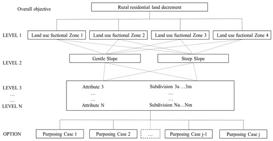
Figure 3.
Decision model for repurposing cases of RRL.
2.3.3. Prediction Methodologies
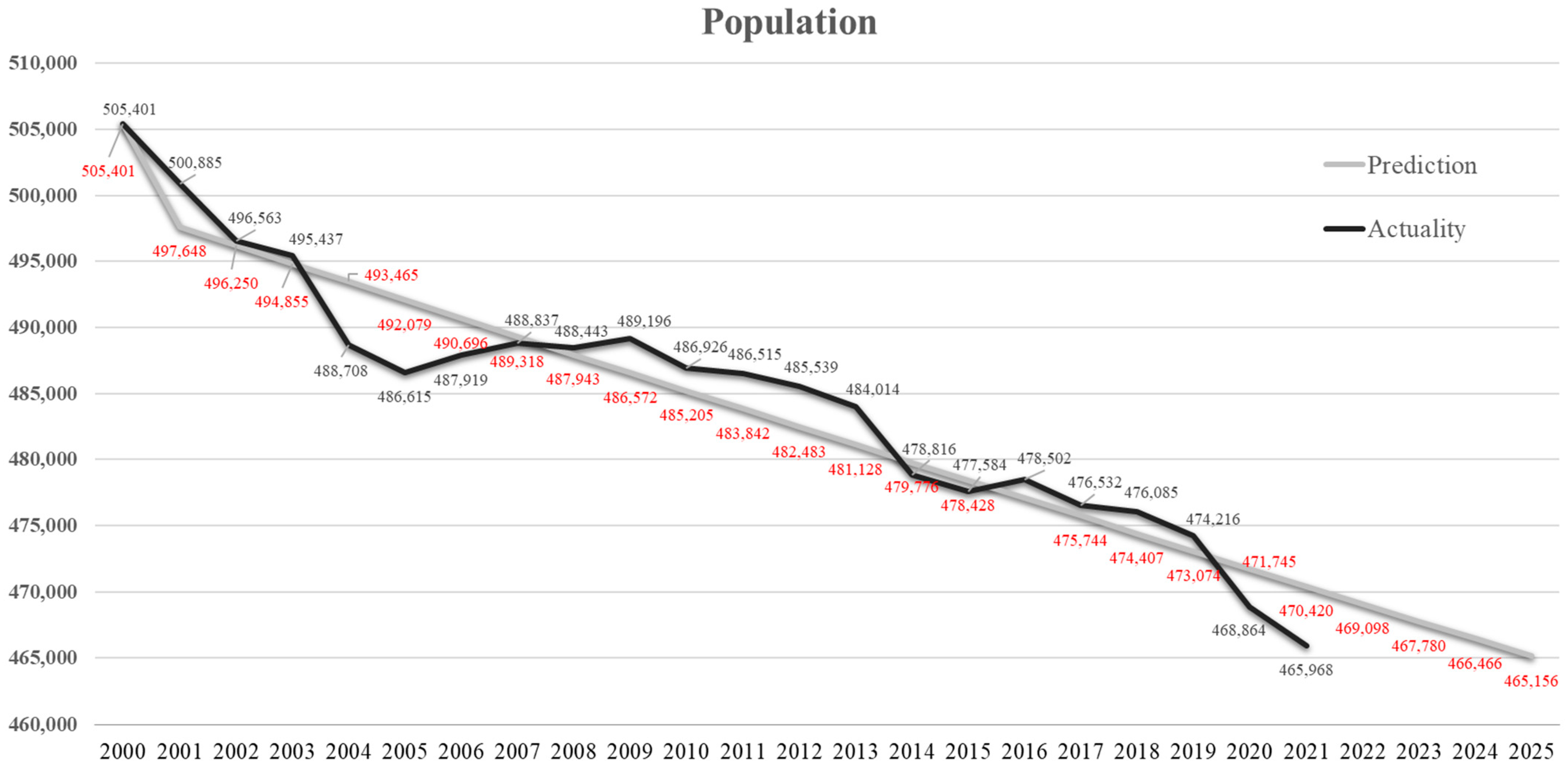
Grey forecasting model: In practice, the total number of stable rural residential lands is limited and determined by the expected total amount of population. Thus, the first-order, one-variable grey model is used to forecast the rural population in the target year. The grey forecasting model is expressed as GM (1, 1), which examines variations within a system to discover a relationship between the sequence and data; a valid forecast is then made [45]. This study applied the GM (1, 1) to forecast the population of Fang County in 2025 using census data from 2000 through 2021.
Three machine learning techniques: Prediction techniques assist in land-use decision making by identifying which lands should be retained or transferred [46]. Three machine learning techniques, including random forest, supported vector machine, and naïve Bayes, were applied by following the analytic paradigm in a previous study that identified residential lands vulnerable to abandonment [47]. This study also follows the framework proposed in the study of Xu et al. [47] that includes the predicting variables covering location, soil, and living conditions. The analytic parameters and descriptions were omitted due to the new focuses of this study rather than the mature repetitive work.
2.3.4. Carbon Emission Assessment Model Based on Land Use
A land-based carbon emission assessment model was used to calculate the quantity of carbon emissions (sequestration) according to the coefficients of different land-use types. In the practice of China’s land-based carbon emission accounting, woodland, garden land, and grassland were considered the main sources of carbon sinks; farmland and construction (e.g., residential) land were regarded as the contributors of carbon emissions [4,48]. The Intergovernmental Panel on Climate Change (IPCC) and the existing literature on China’s land-use carbon emissions (sequestration) have clarified the typical carbon emission (sequestration) coefficient of land-use types. The coefficients of farmland, woodland, garden land, and grassland and their literature sources are shown in Table 3.
Table 3.
Carbon emission (sequestration) coefficients of different land-use types (kg/m2·y).
The formula presents the change in carbon emission (sequestration) capacity as follows:
where ΔEL is the total change in carbon emission (sequestration) capacity according to land-use change; a positive value indicates net carbon emission, while negative one indicates net carbon sequestration. Δei is the carbon emissions from the change in land-use type i, and αi denotes the carbon emission (sequestration) coefficient of land-use type i.
2.4. Data Sources
The dataset used in this study came from two primary sources: (1) spatial data retrieved from a land-use dataset, agricultural thematic dataset, and specialized terrain dataset (with most of the data undergoing secondary processing using the ArcGIS toolset); and (2) statistical data gathered directly or through intermediate calculations from the statistical yearbook of Fang County. In the base year 2020, Fang County had 53,245 land parcels in total, with 52,997 classified as rural land parcels. Of those rural lands, 14,013 parcels were designated for residential use. A new round of field investigations allowed us to randomly collect 973 RRL samples of which 364 were confirmed abandoned and 609 were in active use. Using these investigation samples and building on the concepts of Xu et al. [47], we updated the prediction results of residential land suitable for retention, and accordingly, for decrement.
3. Results
3.1. Land-Use Function Orientated Zone
The classification trinity cases and corresponding four function orientated zones are shown in Figure 4. As described previously, A, B, and C indicate three grades of each criterion layer from high to low.
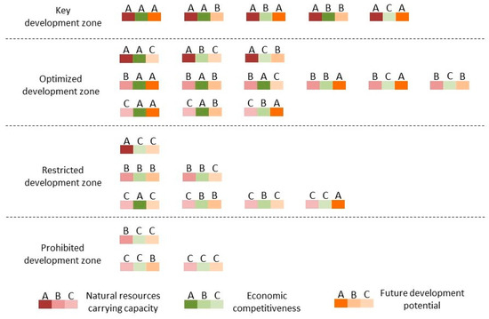
Figure 4.
Classification of trinity cases and corresponding function zones.
The brief descriptions of each function zone are as follows:
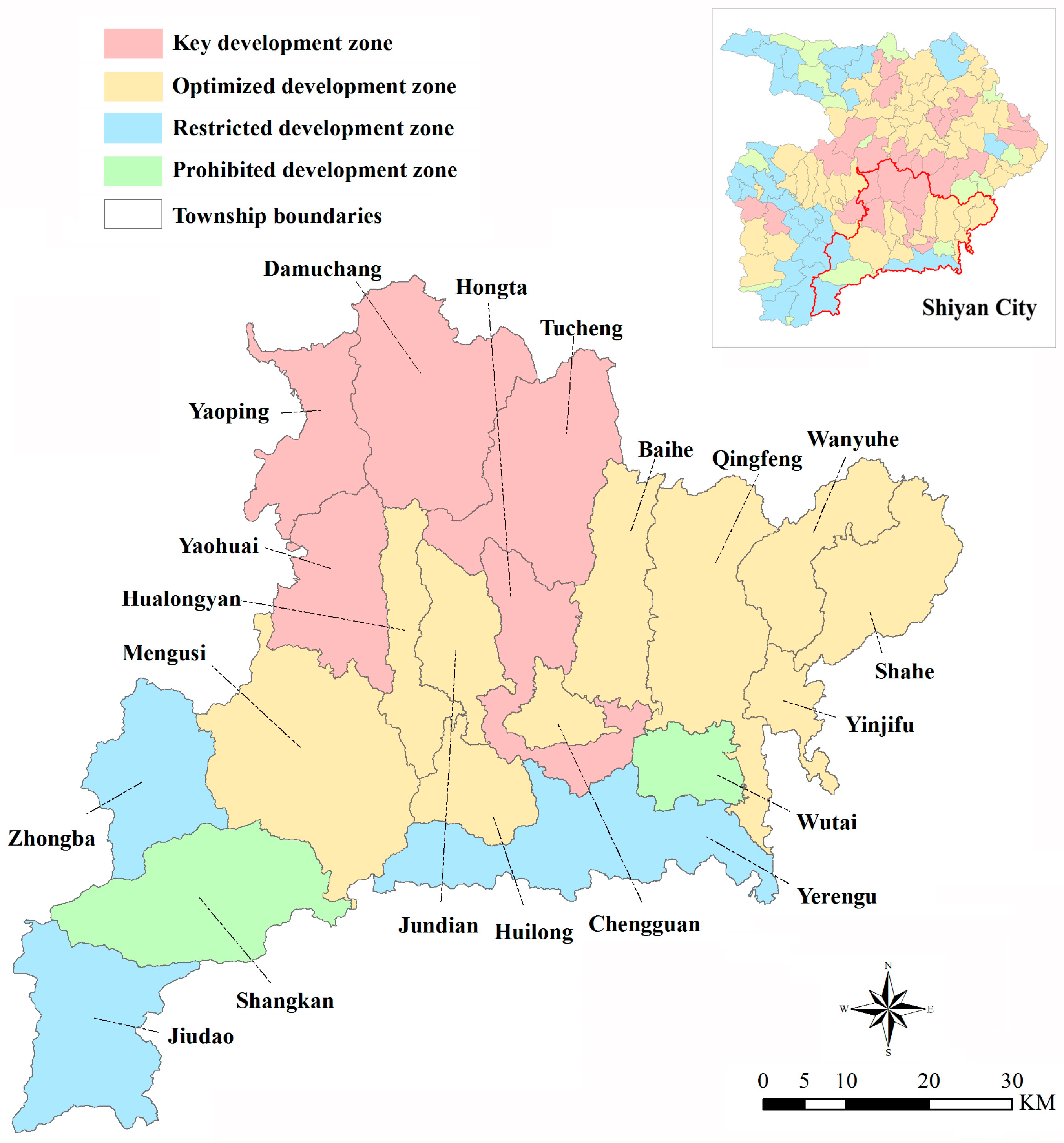
Key development zone: In this zone, the carrying capacity of natural resources is robust, and the potential for future development is significant. Economic growth is the primary objective. Large-scale exploitation activities are accepted and encouraged. Land use can be optimized to accommodate a larger population and more economic activities. Local land repurposing aims to facilitate further development activities.
Optimized development zone: This zone has one of two primary characteristics: either a strong carrying capacity of natural resources but poor potential for future development, or strong competitiveness with good potential for land development but a low carrying capacity of resources and environment. The purpose of local land-use optimization is to adjust land use spatially for coordinated development.
Restricted development zone: This zone has a high carrying capacity of natural resources, but its development potential is weak, and vice versa. To alleviate the conflict between conservation and development, expanded land development should be limited. Local RRLD aims to control the total quantity by promoting the conversion of surplus built-up lands to other purposes.
Prohibited development zone: In these areas, the carrying capacity of natural resources is relatively poor, and both economic development and potential are low. Expanded development is not an option at any time. Ecological conservation strategies should be prioritized. The RRLD should aim to transfer as many built-up lands as possible to support the ecological accumulations.
The spatial distributions of land-use function orientated zoning of Fang County are displayed in Figure 5. The northern portion of the county was designated a key development zone. Optimized development zones were in the central region, including Chengguan and its surrounding towns (except for Hongta), running from east to west. Three southern towns—Zhongba, Jiudao, and Yerengu—were classified as restricted development zones. Prohibited development zones covered Shangkan Town and the Wutai Mountain Forest Farm.
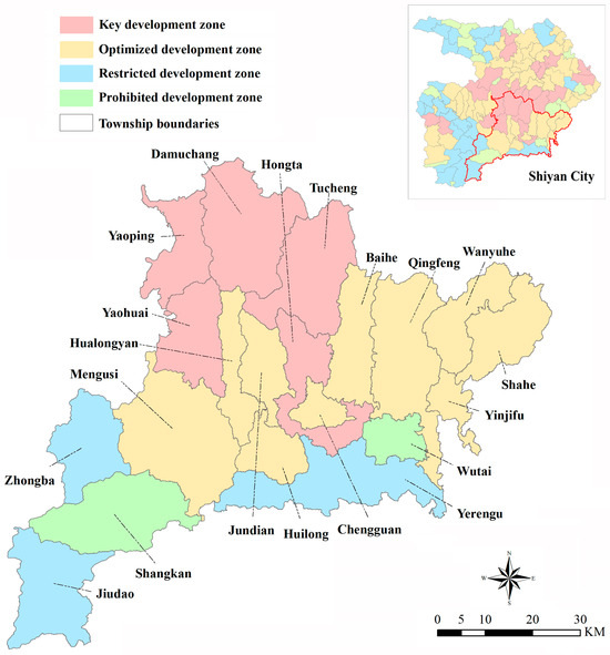
Figure 5.
Land-use function orientated zoning of Fang County.
The zoning results ensure the completeness of land-use function within the entire county and allow us to identify and distinguish where ecological conservation should be prioritized and new development could be encouraged. Land-use preferences, including RRL repurposing cases, should be determined by following the restrictions and incentives of each zone, in which the status of socioeconomic development and that of resources and the environment are clearly stated.
3.2. Criteria of RRLD
For a place like Fang County with strained human–land relationships, ensuring sufficient agricultural space to feed the population and curing the environmental vulnerability are equally important [34]. Therefore, the primary criteria for assisting decision-making were to prioritize agricultural production and ecological conservation. The second priority was to address the demand and spatial optimization of built-up land. Extreme undulating surfaces are better suited for ecological conservation than for living and production. Thus, we determined the best repurposing case for each vulnerable RRL parcel by following the criteria shown in Table 4.
Table 4.
Decision criteria of RRL repurposing.
3.3. RRL for Stable Use and Reserve
The quantity of RRL retained or repurposed is closely tied to the population. To predict the population of Fang County in 2025, the population data from 2000 through 2021 were the initial inputs for the GM (1, 1) model. The results shown in Appendix A illustrate that the population will decrease to 465,156 by 2025. Two indicators—post-error ratio C (0.16) and the probability of a small error P (0.99)—demonstrate an excellent accuracy of the prediction, with a deviation rate of 0.45% [52]. Furthermore, the uncertainty analysis was incorporated to check the stability of the prediction. By gradually removing the earliest input data from the GM (1, 1) model, it showed that the deviation rate was no more than 0.2%, proving the reliability of the initial prediction. Referring to the demographic structure from 2018 to 2022, we projected that the urbanization rate in 2025 would increase slightly to 25%, indicating that the rural population would not exceed 348,867. Since rural planning requires the RRL per capita to not exceed 120 m2, it is concluded that the total RRL area in use in 2025 should be no more than 4186.40 hectares.
The identifications of suitable and unsuitable RRLs were updated and are shown in Appendix B. To improve the robustness of the findings, a series of sensitive tests were considered and used. First, the stepwise removals of feature variables considering their relative importance degrees were introduced to reorganize the training models. Second, a 10-times cross-validation method, parameter tuning, and accuracy testing embedded in model training were used to reduce the overfitting issues. Results showed that suitable RRLs comprised approximately 4535.59 hectares: significantly more than the planned quantity (4186.40 hectares). Hence, it became necessary to identify a portion of suitable RRLs for transfer to a new status. In response, the predicted suitable RRLs are separated into two types: (1) stable utilization, and (2) transfer-out reserves. Less than 0.5% of suitable RRL parcel was larger than 100,000 m2. Moreover, 73.42% of the total number was in communities with areas less than 5000 m2 and no more than 30 residents but comprising only 27.2% of the total area. To reduce the residential dispersion, the long-term use of larger RRL parcels should be prioritized and smaller ones be excluded. In this way, the total area of retained RRL could be reduced to the planned quantity in 2025. Excluded RRLs could be reserved as potential resources for future reuse. The identified stable and reserve RRLs are also shown in Appendix B.
3.4. Multiple Scenarios of RRLD and Its Carbon Emission Response
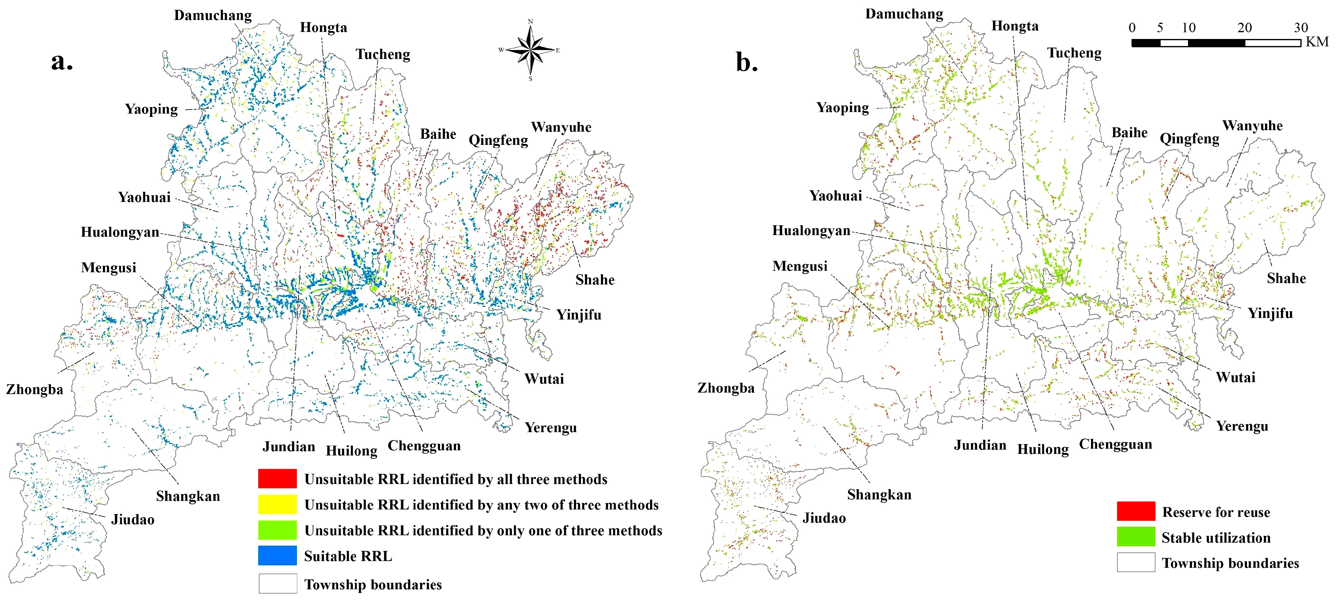
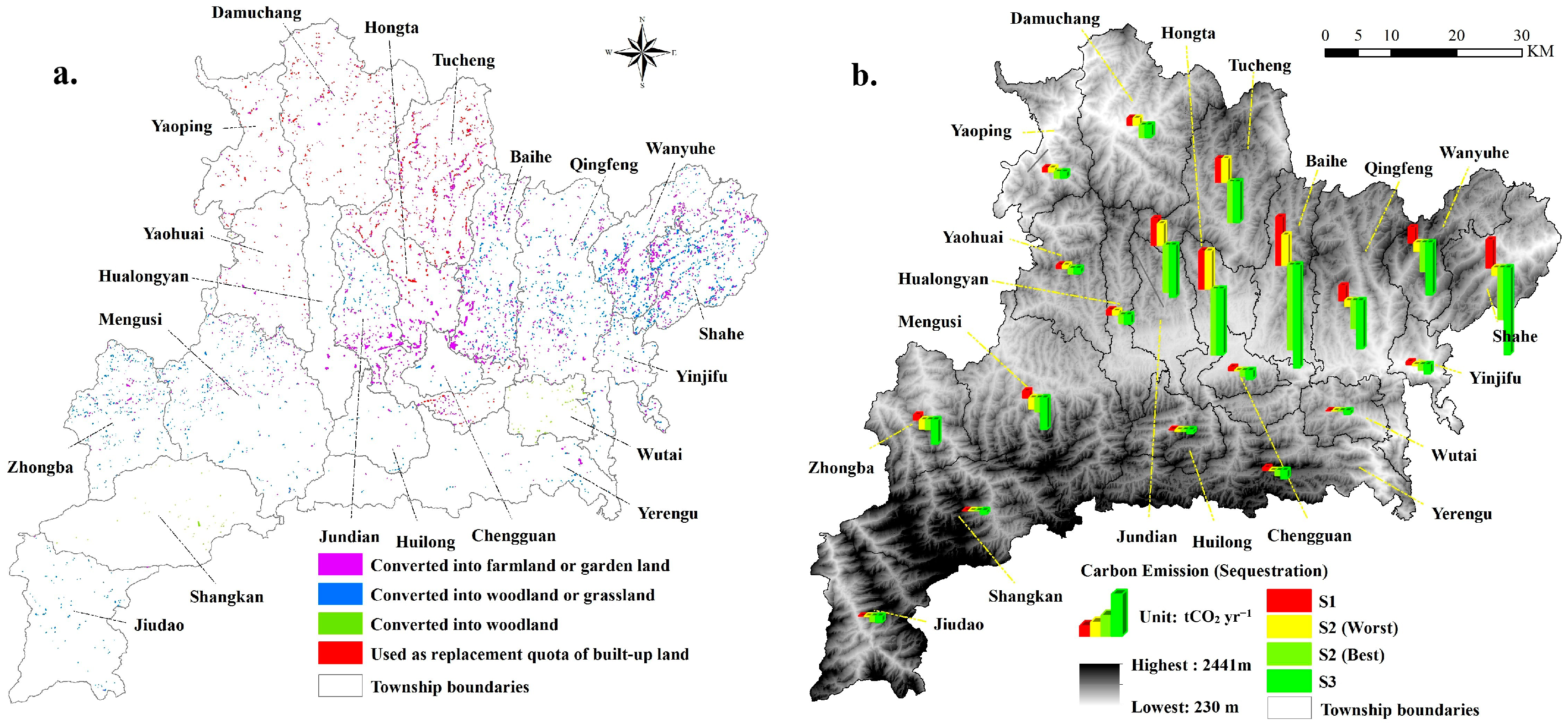
There exist spatial variations when observing the repurposing cases of surplus RRL across Fang County (Figure 6a). The RRLs recommended for conversion to farming or gardening use are located primarily in the central region of the county. Some are located on both sides of the boundary line connecting Wanyuhe and Shahe Township, while others are in the north–central townships. The RRLs designated to replace newly urban, built-up lands are scattered and situated mostly in four northern townships. The RRLs identified for conversion to woodland or grassland are predominantly in Zhongba, Mengusi, Jiudao, and two townships in the northeast corner. Wutai and Shangkan Township, both of which belong to prohibited development zone, have the largest potentials in their net increase of woodland. Based on the decision criteria of RRL repurposing and the preference settings of multiple RRLD scenarios, the quantity of each converted land-use type are shown in Table 5.

Figure 6.
(a) Location of different types of new transferred-in land; (b) carbon emissions (sequestration) under three scenarios.
Table 5.
Quantity of each converted land-use type from RRL under different scenarios (hectares).
Accordingly, the potential carbon emissions or sequestrations in each township under S1, S2, and S3 were calculated and are displayed in Figure 6b.
Under scenario S1, encouraging the productive use, like planting and stockbreeding, should be a priority, which means that the unsuitable RRLs should be reused to increase farmland or grassland as much as possible. Altogether, 20 townships will contribute up to 461.53 tCO2 yr−1 emissions since they convert 1155.34 hectares of RRLs to farmland. Among the townships, Baihe can become the largest carbon emitter (97.43 tCO2 yr−1), since 234.16 hectares of unsuitable RRL are recommended to supplement agricultural resources.
Under scenario S2, improving the agriculture and ecology are equally important. The RRL repurposing should focus on adding “productive” and “green” resources. Either converting to farmland/woodland, or garden land/grassland are optional. The emission (sequestration) change will range from −869.14 tCO2 yr−1 to 150.76 tCO2 yr−1 in total. When farmland and woodland are the main supplements, Hongta will emit the most CO2 (77.41 tCO2 yr−1), and conversely, Menggusi can increase to 77.41 tCO2 yr−1 in their carbon sequestration capacity. When all RRLs convert to garden land and grassland, the maximum and minimum contributors in promoting carbon sequestration capacity are Baihe (172.32 tCO2 yr−1) and Huilong (3.11 tCO2 yr−1), separately.
Under scenario S3, prioritizing eco-environment protection and converting the RRLs into the one that has a relatively high capacity of carbon sequestration are the main targets. By doing so, RRLD will result in the annual carbon sequestration of approximately 1179.91 tCO2 across the county. Baihe and Wutai can provide the highest and lowest capacity of new carbon stock (209.07 tCO2 yr−1 and 7.01 tCO2 yr−1) because they separately own the most and least RRLs to be repurposed.
Since a portion of RRLs are already abandoned or inefficient, there is a risk of underestimating the carbon emission reduction via RRLD. Thus, we calculate this part of the emission change according to the expected population by 2025 and the rural residential carbon emission coefficient proposed by Wu et al. [53]. The carbon emissions in Fang County can additionally decrease by 68.80 tCO2 yr−1 due to the population loss by 2025.
4. Discussion
4.1. Policy Implications
A proactive RRLD is of regional importance, with major implications to reduce land waste, green the land surface, and improve the carbon budget [28,53]. This strategy can serve as a positive catalyst in any places of the world that face challenges from resources and the environment. Our study aligns with existing ones that recommend land-use planning to regulate and reorganize activities in rural areas, especially those with vulnerable environments but depopulation trends [29,54].
First, targeted policies should be developed to assist with the RRLD strategy to improve community equity, promote the eco-environment, and thus increase the farmers’ welfare [18,34]. The amount of retained RRL should be controlled, and RRL expansion that does not comply with the planning should be strictly restricted in physically fragile but depopulated areas. More importantly, any RRLD or land-use planning that looks good initially could end up a failure. A land decrement strategy is not a one-dimensional decision-making process and cannot be implemented without considering background and policies. It is essential to ensure an all-way household engagement when seeking a systematic land-use reallocation [55]. An engagement process that fails to address the power imbalances among stakeholders (for example, the government rather than households determining the land uses) or fails to maximize household engagement may result in negative outcomes, such as impractical or unsustainable RRLD practices. The aims of negotiation on measures to assist RRLD between local government and rural community should involve the consensus on both agricultural and environmental goals, joint protection of the land converted for ecological conservation, equitable allocation of new farmland, and sharing of potential carbon reduction monetization values.
Second, RRLD can result in an increase in the carbon sequestration capacity of the local ecosystem, and free up the space for agriculture and other industries, which are particularly crucial for land-limited areas [20,26]. It should be noted that supplementing farmland as much as possible may always be the primary choice, with an exception being in areas with harsh geographical conditions, such as high altitude or steep slopes, where improving ecological adaptability is more important. This requires us to be more cautious in balancing the relationship between increasing production and reducing carbon emissions, even though anthropogenic emissions occur on top of a natural carbon cycle, threatening the carbon circulation between the atmosphere and terrestrial biosphere. Thus, effective but low-carbon activities rely heavily on the transformation of greening development in rural areas [56]. From the perspectives of both land use and space, the introduction of green technologies and low-carbon lifestyles can both reduce the carbon emissions per unit of land in rural areas. One example is the deployment of solar energy storage equipment in vertical spaces such as rooftops. Additional beneficial measures would include an improved land-use management to reduce carbon emissions associated with management failures, particularly forest fires, illegal deforestation, and disorderly residential expansion in environmentally vulnerable areas.
Third, land-use policy reform should emphasize motivating the behaviors of greening the vacant or inefficient rural land surface with no legal risks. For example, it is necessary to clarify the legitimacy of transferring the development rights of the stock RRL parcels [57]. This enables the user of an abandoned RRL to sell, lease, or even abandon his assets, making it possible to redevelop the terrestrial ecosystems by using the currently unused land resources. On a voluntary basis, the property rights of the land and houses of farmers involved in the RRLD projects should be legally protected, and the monetary compensation of their withdrawals is essential. Similarly, the interests of any public sectors or private enterprises in investing in the repurposing projects of the surplus RRLs should be guaranteed to ensure the sustainability of their investment. Other supporting laws, regulations, or monetary means should be utilized to ensure the abandoned RRLs are repurposed for agricultural and ecological use through engineering projects, which is in strict accordance with functional zoning.
4.2. Limitations and Future Directions
Although this study provides a new and proactive RRL use strategy that improves the associated carbon emission capacity regionally, it does have certain limitations. First, determining the RRLD is contextual because the influential factors vary so much due to the specific targets and restrictions. Second, this study inevitably oversimplifies the changes in carbon emissions and assumes the carbon emissions or sequestration of a region as constant values without temporal changes. Third, the CO2 changes resulting from the conversion between various land-use types (non-RRLs) are deliberately ignored. Besides, the absence of spatial correlation analyses and hotspot identifications of RRLD, and the investigation of other localized impacts of land-induced carbon emissions would influence the refinement of land-use and carbon-reduction policies. Future research should focus on a more grounded and refined understanding of RRLD, and more reasonable estimates of carbon emissions via rural land-use change.
5. Conclusions
Aiming at assessing the environmental consequence of a proactive land-use strategy in an environmentally fragile but depopulated area, this study proposed a framework for designing the RRLD and estimating the associated carbon emission changes. The framework combines land-use function orientated zoning techniques, decision models, and scenario analyses. A case study of Fang County in China provides some findings that can be the reference for similar regional or relevant land-use carbon studies, in which policymakers attempt to pursue a better mitigation of carbon emissions via adjusting the land-use structures and innovating land-use management.
The RRLD illustrates and determines which RRLs are retained, which are converted to other purposes, and how they are repurposed. Up to 4186.40 of the 4535.59 hectares suitable RRL should be retained and the reminder can be treated as transfer-out reserves. More than 2012.23 hectares of RRLs were identified as unsuitable and vulnerable to abandonment. The RRLs recommended for conversion to farming or gardening use (more than half of the total amount) were in the central part of the county, and for conversion to woodland or grassland, were predominantly in Zhongba, Mengusi, Jiudao, and two northeastern townships. Two prohibited development zones, Wutai and Shangkan, had the largest potentials to increase their woodlands.
The carbon emission consequences of RRLD depend on the scenario setting. When putting agriculture as a priority, most townships will increase their net carbon emissions (ranging from 16.80 kgCO2 yr−1 to 77.41 tCO2 yr−1) because their new added farmlands are net carbon positive. For S2, which balances agriculture and ecology, it reveals distinct differences in the direction and magnitude of carbon emission changes among the townships. The largest contributors of increased carbon emissions and sequestration will be Hongta (77.41 tCO2 yr−1) and Baihe (172.32 tCO2 yr−1). Under S3, all the townships will significantly increase their capacities of carbon sequestration (between 7.01 tCO2 yr−1 and 209.07 tCO2 yr−1). These findings suggest that if land-use structures and management can be effectively optimized by implementing the RRLD, the carbon sequestration capacity of local terrestrial ecosystems would be promoted.
Author Contributions
Conceptualization, F.X. and G.C.; methodology, F.X.; software, H.W.; formal analysis, F.X. and H.W.; investigation, F.X.; data curation, F.X.; writing—original draft preparation, F.X. and G.C.; writing—review and editing, G.C.; visualization, F.X.; supervision, G.C.; funding acquisition, F.X. and H.W. All authors have read and agreed to the published version of the manuscript.
Funding
This research was funded by the National Natural Science Foundation of China, grant numbers 42001206 and 42371286; the National Social Science Foundation of China, grant number 22CJY041; the Key Laboratory for Law and Governance of the Ministry of Natural Resources, grant number CUGFP–1904; the School of Public Administration at China University of Geosciences, grant number CUGGG–2002; and the “CUG Scholar” Scientific Research Funds at China University of Geosciences (Wuhan), grant number 2022186.
Data Availability Statement
The data presented in this study are partially available on request from the corresponding author. These data are not all publicly available due to confidential information that requires government approval for release.
Acknowledgments
The authors thank Hongwei Zhang, Desheng Li, and other members in Zhanqi Wang’s lab for their assistance in the field investigation and data acquisition.
Conflicts of Interest
The authors declare no conflicts of interest.
Appendix A

Figure A1.
Prediction of registered population in Fang County based on the census data from 2000 to 2021. Note: The red number indicates that the prediction value that was rounded to the nearest whole number.
Figure A1.
Prediction of registered population in Fang County based on the census data from 2000 to 2021. Note: The red number indicates that the prediction value that was rounded to the nearest whole number.
Appendix B
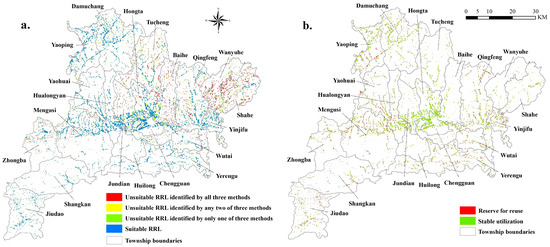
Figure A2.
(a) Locations of suitable and unsuitable rural residential lands using three machine learning methods; (b) Locations of residential land for stable use and transferred-out reserves.
Figure A2.
(a) Locations of suitable and unsuitable rural residential lands using three machine learning methods; (b) Locations of residential land for stable use and transferred-out reserves.
References
- Intergovernmental Panel on Climate Change (IPCC). Climate Change 2007: The Physical Science Basis; Contribution of working group I to the fourth assessment report of the Intergovernmental Panel on Climate Change; Cambridge University Press: Cambridge, UK, 2007. [Google Scholar]
- Sleeter, B.M.; Sohl, T.L.; Bouchard, M.A.; Reker, R.R.; Soulard, C.E.; Acevedo, W.; Griffith, G.E.; Sleeter, R.R.; Auch, R.F.; Sayler, K.L.; et al. Scenarios of land use and land cover change in the conterminous United States: Utilizing the special report on emission scenarios at ecoregional scales. Glob. Environ. Change 2012, 22, 896–914. [Google Scholar] [CrossRef]
- Arneth, A. Historical carbon dioxide emissions caused by land-use changes are possibly larger than assumed. Nat. Geosci. 2017, 10, 79–84. [Google Scholar] [CrossRef]
- Chang, X.; Xing, Y.; Wang, J.; Yang, H.; Gong, W. Effects of land use and cover change (LUCC) on terrestrial carbon stocks in China between 2000 and 2018. Resour. Conservat. Recycl. 2022, 182, 106333. [Google Scholar] [CrossRef]
- Gray, C.L. Environment, land, and rural out-migration in the southern Ecuadorian Andes. World Dev. 2009, 37, 457–468. [Google Scholar] [CrossRef]
- Xia, C.; Zhang, J.; Zhao, J.; Xue, F.; Li, Q.; Fang, K.; Shao, Z.; Zhang, J.; Li, S.; Zhou, J. Exploring potential of urban land-use management on carbon emissions— A case of Hangzhou, China. Ecol. Indic. 2023, 146, 109902. [Google Scholar] [CrossRef]
- Gasser, T.; Crepin, L.; Quilcaille, Y.; Houghton, R.A.; Ciais, P.; Obersteiner, M. Historical CO2 emissions from land use and land cover change and their uncertainty. Biogeosciences 2020, 17, 4075–4101. [Google Scholar] [CrossRef]
- Levy, P.E.; Friend, A.D.; White, A.; Cannell, M.G.R. The influence of land use change on global-scale fluxes of carbon from terrestrial ecosystems. Clim. Chang. 2004, 67, 185–209. [Google Scholar] [CrossRef]
- Li, L.; Huang, X.; Yang, H.; Chuai, X.; Zhang, M.; Zhong, T.; Chen, Z.; Chen, Y.; Wang, X.; Thompson, J.R. Carbon emissions from land-use change and management in China between 1990 and 2010. Sci. Adv. 2016, 2, e1601063. [Google Scholar] [CrossRef]
- Tang, X.; Zhao, X.; Bai, Y.; Zhou, G. Carbon pools in China’s terrestrial ecosystems: New estimates based on an intensive field survey. Proc. Natl. Acad. Sci. USA 2018, 115, 4021–4026. [Google Scholar] [CrossRef]
- Yuan, Y.; Chuai, X.; Xiang, C.; Gao, R. Carbon emissions from land use in Jiangsu, China, and analysis of the regional interactions. Environ. Sci. Pollut. Res. 2022, 29, 44523–44539. [Google Scholar] [CrossRef]
- Fan, L.; Cai, T.; Wen, Q.; Han, J.; Wang, S.; Wang, J.; Yin, C. Scenario simulation of land use change and carbon storage response in Henan Province, China: 1990–2050. Ecol. Indic. 2023, 154, 110660. [Google Scholar] [CrossRef]
- Shu, H.; Xiong, P. Reallocation planning of urban industrial land for structure optimization and emission reduction: A practical analysis of urban agglomeration in China’s Yangtze River Delta. Land Use Pol. 2019, 81, 604–623. [Google Scholar] [CrossRef]
- Gao, J.; Wang, L. Embedding spatiotemporal changes in carbon storage into urban agglomeration ecosystem management—A case study of the Yangtze River Delta, China. J. Clean. Prod. 2019, 237, 117764. [Google Scholar] [CrossRef]
- Zhang, X.; Brandt, M.; Tong, X.; Ciais, P.; Yue, Y.; Xiao, X.; Zhang, W.; Wang, K.; Fensholt, R. A large but transient carbon sink from urbanization and rural depopulation in China. Nat. Sustain. 2022, 5, 321–328. [Google Scholar] [CrossRef]
- Wu, Q.; Wang, X.; Chen, S.; Wang, L.; Jiang, J. Land surface greening and CO2 fertilization more than offset the gross carbon sequestration decline caused by land cover change and the enhanced vapour pressure deficit in Europe. Remote Sens. 2023, 15, 1372. [Google Scholar] [CrossRef]
- de Chazal, J.; Rounsevell, M.D.A. Land-use and climate change within assessments of biodiversity change: A review. Glob. Environ. Chang. 2009, 19, 306–315. [Google Scholar] [CrossRef]
- Li, B.V.; Jenkins, C.N.; Xu, W. Strategic protection of landslide vulnerable mountains for biodiversity conservation under land-cover and climate change impacts. Proc. Natl. Acad. Sci. USA 2022, 119, e2113416118. [Google Scholar] [CrossRef]
- Zhou, L.; Dickinson, R.E.; Tian, Y.; Fang, J.; Li, Q.; Kaufmann, R.K.; Tucker, C.J.; Myneni, R.B. Evidence for a significant urbanization effect on climate in China. Proc. Natl. Acad. Sci. USA 2004, 101, 9540–9544. [Google Scholar] [CrossRef]
- Ye, X.; Chuai, X. Have rural settlement changes harmed ecosystem carbon in China? Appl. Geogr. 2023, 153, 102917. [Google Scholar] [CrossRef]
- Gao, X.; Xu, A.; Liu, L.; Deng, O.; Zeng, M.; Ling, J.; Wei, Y. Understanding rural housing abandonment in China’s rapid urbanization. Habitat Int. 2017, 67, 13–21. [Google Scholar] [CrossRef]
- Ravallion, M.; Jalan, J. China’s lagging poor areas. Am. Econ. Rev. 1999, 89, 301–305. [Google Scholar] [CrossRef]
- Siciliano, G. Urbanization strategies, rural development and land use changes in China: A multiple-level integrated assessment. Land Use Pol. 2012, 29, 165–178. [Google Scholar] [CrossRef]
- Long, H.; Tu, S.; Ge, D.; Li, T.; Liu, Y. The allocation and management of critical resources in rural China under restructuring: Problems and prospects. J. Rural Stud. 2016, 47, 392–412. [Google Scholar] [CrossRef]
- Weissteiner, C.J.; Boschetti, M.; Böttcher, K.; Carrara, P.; Bordogna, G.; Brivio, P.A. Spatial explicit assessment of rural land abandonment in the Mediterranean area. Glob. Planet. Chang. 2011, 79, 20–36. [Google Scholar] [CrossRef]
- Yao, G.; Xie, H. Rural spatial restructuring in ecologically fragile mountainous areas of southern China: A case study of Changgang Town, Jiangxi Province. J. Rural Stud. 2016, 47, 435–446. [Google Scholar] [CrossRef]
- Lambin, E.F.; Meyfroidt, P. Land use transition: Socio-ecological feedback versus socio-economic change. Land Use Pol. 2010, 27, 108–118. [Google Scholar] [CrossRef]
- Long, H.; Li, Y.; Liu, Y.; Woods, M.; Zou, J. Accelerated restructuring in rural China fueled by’ increasing vs. decreasing balance’ land-use policy for dealing with hollowed villages. Land Use Pol. 2012, 29, 11–22. [Google Scholar] [CrossRef]
- Qu, Y.; Jiang, G.; Li, Z.; Tian, Y.; Wei, S. Understanding rural land use transition and regional consolidation implications in China. Land Use Pol. 2019, 82, 742–753. [Google Scholar] [CrossRef]
- Vidal-Legaz, B.; Martínez-Fernández, J.; Picón, A.S.; Pugnaire, F.I. Trade-offs between maintenance of ecosystem services and socio-economic development in rural mountainous communities in southern Spain: A dynamic simulation approach. J. Environ. Manag. 2013, 131, 280–297. [Google Scholar] [CrossRef]
- An Overview of Fang County. Available online: http://www.fangxian.gov.cn/fyfx/fxgk/qhrk/202308/t20230816_4294641.shtml (accessed on 28 August 2023). (In Chinese)
- Land Use Planning of Fang County (2010–2020). Available online: http://www.fangxian.gov.cn/xxgk/fdzdgknr/ghxx/201707/t20170726_1153629.shtml (accessed on 28 August 2023). (In Chinese)
- Zhang, J.; Li, S.; Lin, N.; Lin, Y.; Yuan, S.; Zhang, L.; Zhu, J.; Wang, K.; Gan, M.; Zhu, C. Spatial identification and trade-off analysis of land use functions improve spatial zoning management in rapid urbanized areas, China. Land Use Pol. 2022, 116, 106058. [Google Scholar] [CrossRef]
- Liu, Y. Introduction to land use and rural sustainability in China. Land Use Pol. 2018, 74, 1–4. [Google Scholar] [CrossRef]
- Long, H.; Qu, Y. Land use transitions and land management: A mutual feedback perspective. Land Use Pol. 2018, 74, 111–120. [Google Scholar] [CrossRef]
- Zhou, J.; Cao, X. What is the policy improvement of China’s land consolidation? Evidence from completed land consolidation projects in Shaanxi Province. Land Use Pol. 2020, 99, 104847. [Google Scholar] [CrossRef]
- Xu, D.; Guo, S.; Xie, F.; Liu, S.; Cao, S. The impact of rural laborer migration and household structure on household land use arrangements in mountainous areas of Sichuan Province, China. Habitat Int. 2017, 70, 72–80. [Google Scholar] [CrossRef]
- Fan, J.; Wang, Y.; Wang, C.; Chen, T.; Jin, F.; Zhang, W.; Li, L.; Xu, Y.; Dai, E.; Tao, A.; et al. Reshaping the sustainable geographical pattern: A major function zoning model and its applications in China. Earth Future 2019, 7, 25–42. [Google Scholar] [CrossRef]
- Fang, C.; Liu, X. Comprehensive measurement for carrying capacity of resources and environment of city clusters in Central China. Chin. Geogr. Sci. 2010, 20, 281–288. [Google Scholar] [CrossRef]
- Shen, L.; Cheng, G.; Du, X.; Meng, C.; Ren, Y.; Wang, J. Can urban agglomeration bring “1 + 1 > 2Effect”? A perspective of land resource carrying capacity. Land Use Pol. 2022, 117, 106094. [Google Scholar] [CrossRef]
- Zhang, F.; Wang, Y.; Ma, X.; Wang, Y.; Yang, G.; Zhu, L. Evaluation of resources and environmental carrying capacity of 36 large cities in China based on a support-pressure coupling mechanism. Sci. Total Environ. 2019, 688, 838–854. [Google Scholar] [CrossRef]
- Satty, T.L. A scaling method for priorities in hierarchical structures. J. Math. Psychol. 1977, 15, 234–281. [Google Scholar] [CrossRef]
- Hwang, C.L.; Yoon, K.P. Multiple Attribute Decision Making: Methods and Applications; Springer: New York, NY, USA, 1981. [Google Scholar]
- Tian, G.; Qiao, Z.; Zhang, Y. The investigation of relationship between rural settlement density, size, spatial distribution and its geophysical parameters of China using Landsat TM images. Ecol. Model. 2012, 231, 25–36. [Google Scholar] [CrossRef]
- Tan, G. The structure method and application of background value in grey system GM(1,1) Model (I). J. Theor. Pract. Syst. Eng. 2000, 20, 98–103. [Google Scholar]
- Chen, L.; Sun, Y.; Saeed, S. Monitoring and predicting land use and land cover changes using remote sensing and GIS techniques—A case study of a hilly area, Jiangle, China. PloS ONE 2018, 13, e0200493. [Google Scholar]
- Xu, F.; Ho, H.C.; Chi, G.; Wang, Z. Abandoned rural residential land: Using machine learning techniques to identify rural residential land vulnerable to be abandoned in mountainous areas. Habitat Int. 2019, 84, 43–56. [Google Scholar] [CrossRef]
- Zhu, E.; Deng, J.; Zhou, M.; Gan, M.; Jiang, R.; Wang, K.; Shahtahmassebi, A. Carbon emissions induced by land-use and land-cover change from 1970 to 2010 in Zhejiang, China. Sci. Total Environ. 2019, 646, 930–939. [Google Scholar] [CrossRef] [PubMed]
- Sun, X. Effects of carbon emission by land use patterns in Hefei’s economic circle of Anhui Province. J. Nat. Resour. 2012, 27, 394–401. (In Chinese) [Google Scholar]
- Zhao, R.; Huang, X.; Zhong, T.; Chuai, X. Carbon effect evaluation and low-carbon optimization of regional land use. Trans. Chin. Soc. Agric. Eng. 2013, 29, 220–229. (In Chinese) [Google Scholar]
- Fang, J.; Guo, Z.; Piao, S. Terrestrial vegetation carbon sinks in China, 1981 to 2000. Sci. China Ser. D 2007, 50, 1341–1350. (In Chinese) [Google Scholar] [CrossRef]
- Deng, J. Grey Forecasting and Decision; Huazhong University of Science and Technology Press: Wuhan, China, 1986. [Google Scholar]
- Wu, S.; Hu, S.; Frazier, A.E.; Hu, Z. China’s urban and rural residential carbon emissions: Past and future scenarios. Resour. Conservat. Recycl. 2023, 190, 106802. [Google Scholar] [CrossRef]
- Smith, M.D.; Giraud, D. Traditional land-use planning regulation and agricultural land conservation: A case study from the USA. Plan. Pract. Res. 2006, 21, 407–421. [Google Scholar] [CrossRef]
- Ma, S.; Mu, R. Forced off the farm? Farmers’ labor allocation response to land requisition in China. World Dev. 2020, 132, 104980. [Google Scholar] [CrossRef]
- Barbier, E.B. Is green rural transformation possible in developing countries? World Dev. 2020, 131, 104955. [Google Scholar] [CrossRef]
- Kong, X.; Liu, Y.; Jiang, P.; Tian, Y.; Zou, Y. A novel framework for rural homestead land transfer under collective ownership in China. Land Use Pol. 2018, 78, 138–146. [Google Scholar] [CrossRef]


Disclaimer/Publisher’s Note: The statements, opinions and data contained in all publications are solely those of the individual author(s) and contributor(s) and not of MDPI and/or the editor(s). MDPI and/or the editor(s) disclaim responsibility for any injury to people or property resulting from any ideas, methods, instructions or products referred to in the content. |
© 2024 by the authors. Licensee MDPI, Basel, Switzerland. This article is an open access article distributed under the terms and conditions of the Creative Commons Attribution (CC BY) license (https://creativecommons.org/licenses/by/4.0/).