1. Introduction
Sprawl areas constitute an increasing part of urban and metropolitan areas. This type of urbanization, characterized by low densities and discontinuity of built space, has a significant social and environmental impact. Negative consequences include increased pollution, decreased accessibility to employment, increased social isolation and segregation, and excessive conversion of farmland and natural spaces to urban uses [
1]. Evidence has also been found that it decreases people’s satisfaction with livability [
2]. This is why the management of such spaces is a major challenge for urban planning, especially when these spaces, as is the case in metropolitan areas, go beyond municipal administrative boundaries, which is the usual framework for planning in Spain. As was noted in [
3], the metropolitan reality in the Valencian Region has been present for decades, but local governments show resistance to the cooperation and coordination with other forms of governance that could affect their competences, included the urban planning competences. This may imply not only a lack of coordination of urban strategies, but also competition between administrations to attract investment, which can trigger a negative dynamic for the sustainable use of the territory [
4,
5]. It can be said that this type of space is an example of the mismatch between the sphere in which economic agents act, and the sphere in which the administration acts, anchored at the local level and, therefore, inadequate to control the dynamics of urbanization [
6].
Alternative policies include the reinforcement of the compact city and the strengthening of metropolitan sub-centers, the mixing of functions, the improvement in access to housing, and the articulation of an efficient public transport system. In this sense, territorial policies aimed at articulating the metropolitan region as a polycentric network of cities, each of which is characterized by its physical compactness and the wealth of uses within it, are considered necessary. In [
6], four possible strategies for dispersed suburban spaces are identified: selective densification, i.e., taking advantage of typological differences to complete the spaces of dispersed urbanization; typological reformulation, through changes in urban planning regulations that modify the system of open spaces and structuring elements such as volumetrics, heights, and general organization of collective spaces; the enhancement of suburban centrality, through the location of uses that generate urban attractiveness in strategic locations between urbanizations, i.e., creating proximity centrality; and, finally, a comprehensive intervention that considers not only the physical aspect, but also the social, environmental, and cultural aspects, for the social construction of a collective perception of the territory and an urban identity. Other authors point to the need to combine redensification strategies with planning that incorporates urban green infrastructure to avoid the loss of green spaces and contribute to the sustainability of the compact city [
7].
However, specific studies have shown that urban sprawl is not a univocal phenomenon, but can take different forms in terms of density and spatial pattern, with different territorial consequences. Specialized literature identifies different dimensions of both the intensity and the spatial pattern of urban sprawl that can be found simultaneously within the same urban space, even if there is a predominant pattern. Therefore, the efficient and effective implementation of these strategies requires an accurate knowledge of the characteristics of the process of suburban sprawl, as well as a temporal monitoring of its evolution in order to evaluate its results. Consequently, it is necessary to use different indicators to measure and characterize urban sprawl. In many cases, studies use the urban or metropolitan set as a scale, defining urban space either by prior administrative delimitations (as in the case of the US metropolitan areas), on the basis of morphological criteria such as the European Metropolitan Urban Areas [
8], or—which is generally considered more appropriate—on the basis of functional criteria, usually on the basis of residential residential–work mobility [
9,
10,
11]. This consideration of the metropolitan whole is very useful for comparing metropolitan areas, but it does not allow the identification of the different spatial patterns that occur within them, preventing the adaptation of planning strategies to the specific characteristics of each space.
When the analysis is applied at the intra-metropolitan scale, the preferred territorial unit of choice is the municipality, which, as the territorial scope of planning, is particularly relevant [
12]. However, empirical analyses have shown that within metropolitan areas it is possible to find different processes of urban growth that give rise to distinct urban sprawl patterns, thus requiring the application of specific policies for each case. The municipal division is insufficient to characterize these processes internal to the metropolitan area, since one of the specific characteristics of urban sprawl is that its growth gives rise to large and unconnected areas that can extend over contiguous municipalities, requiring specific planning measures that go beyond the local planning framework. It is therefore considered that the use of municipal administrative boundaries for the calculation of indicators distorts and blurs the characteristics of these intra-metropolitan supra-municipal areas, preventing their characterization, the definition of their problems, and the monitoring of their evolution over time.
To overcome this difficulty, in this article we use a delimitation of territorial units based on fractal methodology, which makes it possible to avoid administrative boundaries, identifying areas of dispersed supra- and infra-municipal urbanization based on the morphology of the area [
13]. The fractal methodology makes it possible to identify the spatial limits of an urban pattern from the data itself, without the need to use a prior threshold, making it ideal for identifying the “natural” spatial units defined by the spatial pattern of the built space itself. The morphological units serve as a basis for the measurement of the different dimensions of urban sprawl, and the elaboration of a typology that allows us to characterize the phenomenon in a specific way, as well as to monitor its intensity and characteristics in the future. It could be used as a guide for the design of specific policies on a supra-municipal scale. The indicators are selected in such a way that they reflect the main dimensions of urban sprawl, are easy to obtain, and allow their application in different geographic and planning contexts.
This methodology is applied in the metropolitan area of Valencia, a Spanish metropolitan area of 1,994,565 inhabitants (792,492 in the central municipality) located on the Mediterranean coast. The area has experienced intense urban sprawl, especially in the period 1990–2013, under the real estate bubble process. From 1987 to 2005, the increase in artificial land in the Valencian region was 76,25%, much higher than the average for Spain (51.87%) and Europe (9.62%) [
14].
Our objective is therefore twofold: (1) to identify the most suitable morphological units of analysis to identify urbanization processes, based on fractal methodology; and (2) to perform a morphometric analysis that allows us to characterize these morphological units in terms of the basic dimensions of urban sprawl.
The article is structured as follows: firstly, the study area is presented (
Section 2); secondly, the state of the art concerning the processes of dispersion and delimitation of urban areas, as well as the dimensions and indicators, are presented (
Section 3). This is followed by the section on materials and methods, which specifies the sources of data used in this work and the methodology to be used (
Section 4). Finally, the sections on results, discussions, and conclusions are presented (
Section 5,
Section 6 and
Section 7).
2. Area of Study
Since the beginning of the 20th century, the Spanish Mediterranean has been characterized by a disproportionate expansion of urbanization processes. As in other countries, in Spain, there have been territorial processes in recent years that have led to a change in the city model. Improvements in communication and transport systems, new residential preferences, and, in some cases, private interests that public policies have been unable or unwilling to control, have led to the spread of suburbanization processes, giving rise to what has been called the “dispersed city” or “diffuse city” [
15,
16,
17].
This has been the case in the metropolitan area of Valencia, where there is currently a large metropolitan area where the suburbanization processes mentioned above can be observed. According to a study on the formation of this metropolitan area and the main means of transport [
18], it was the railway network that modeled the expansion of the population and residential location until 1981, while from that time onwards the automobile was the means with the greatest capacity for territorial transformation and location of the population. Taking into account Corine Land Cover data, between 2000 and 2006 almost 46 million m
2 of metropolitan land was transformed into urbanized land, with a clear predominance of low-density models [
19,
20,
21]. This process has continued until very recently, since, despite the impact of the economic crisis of 2008, the rate of growth of developable land continued to exceed that of urbanized land until 2013, due to the maintenance of the expectations of municipalities, which hoped to recover the pre-crisis rate of construction [
22]. Consequently, the growth of built-up space during the period 1991–2015 has been three times higher than population growth, contributing to the reduction in highly productive agricultural space, the fragmentation of the territory, and the conurbation of municipalities [
23].
As a result, a space of strong urban continuity has been configured in which it is not easy to identify elements of discontinuity or morphological rupture that allow the definition of the limits of the urban units, with the consequent problems of management and planning. This model of high consumption of resources, linked to mobility by private transport, generates significant negative externalities. As an example, the cost of maintaining the services induced by urban sprawl has been evaluated in the Valencia region to have increased 20%, although in some municipalities these percentages exceed 40% with respect to the average costs of providing basic services [
12].
In response, the Territorial Strategy of the Valencian Community, the framework document for land-use planning in the region, as well as the Territorial Plan for the Metropolitan Area of Valencia (PATEVAL), the main instrument for sub-regional planning, have set, as one of their objectives, defining the areas of low density and remoteness from the compact urban fabrics, as non-sustainable, to be extinguished or restructured. One of the following strategies is established for each of these urban areas [
23]: (a) enhancement of elements of urban centrality through the implementation of basic facilities and public and private services; (b) articulation of these spaces with consolidated urban centers; (c) creation of new centralities on the structuring elements of these fabrics, with pieces of higher density and urban intensity; (d) articulation of public transport on these structuring elements; and/or (e) densification of this type of land in the vicinity of access points to the sustainable transport network.
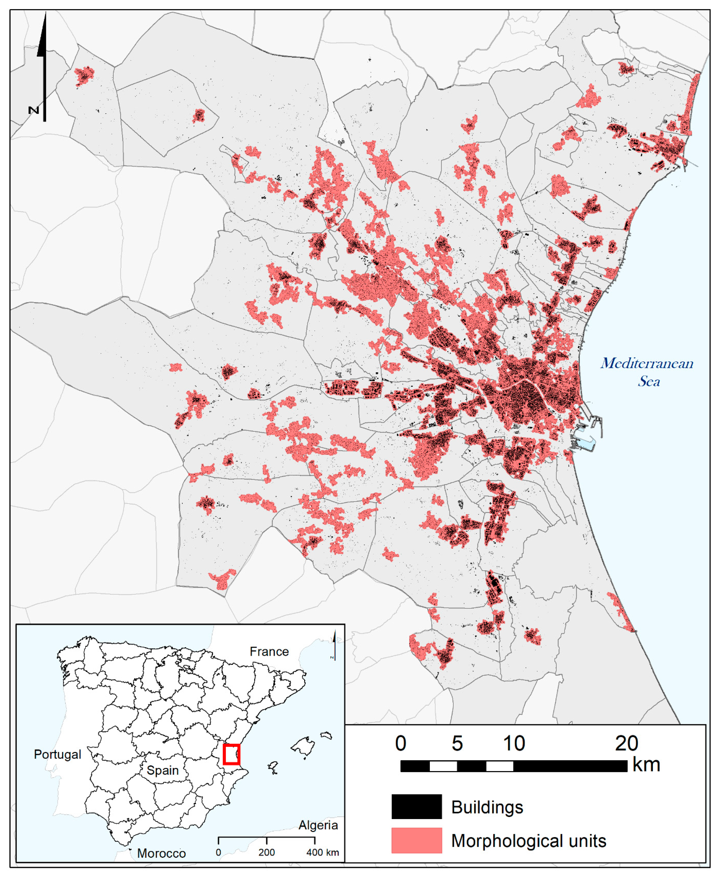
The study area considered is the one defined on the basis of functional criteria by [
24]. As recommended by different authors [
10,
11,
12], the main criterion applied for its delimitation is the existence of residence–work mobility flows, although corrected by some demographic criteria. This area includes 80 municipalities, and totaled 1,994,565 inhabitants in 2022, occupying an area of 2212.57 km
2 (
Figure 1).
6. Discussion
The technique of delimitating urbanized spaces based on fractal methodology allows the identification of morphological units that can be analyzed from the point of view of their urban sprawl characteristics. The results obtained are considered to be relevant, especially on three levels.
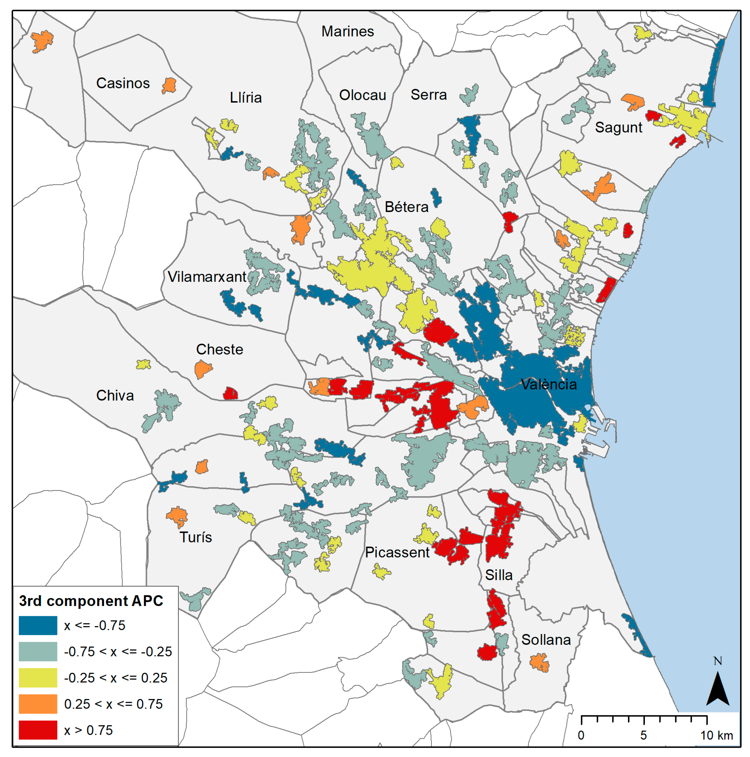
The first is related to the identification of intra-metropolitan morphological units. It should be noted that the area is characterized by a high degree of urban dispersion, with 131 discontinuous morphological units of more than 50 hectares having been identified on the basis of the existing breaks in the fractal pattern of the footprint of built space. Most of these correspond to mixed spaces with a predominance of residential uses, although there are also several areas, some of a certain extension, of an exclusively industrial, commercial, or tertiary nature.
The identification of these morphological units has allowed the focus of analysis to be lowered to the intra-metropolitan scale, also escaping the local administrative boundaries which, although relevant for planning purposes, prevents the joint analysis of spaces that go far beyond these limits. The number of municipalities over which the morphological areas extend are shown in
Table 6. Thus, of the areas analyzed, 47% extend over more than one municipality, and 21% over three or more, which poses a major problem for the coordination of planning policies. Leaving aside the central metropolitan core, the cases included in group 2 are particularly striking, where we find discontinuous suburban areas that extend over up to 10 municipalities, which makes it necessary to abandon the municipal perspective in order to find joint planning solutions. To the multiple administrative dependence of these areas, in some cases the discontinuity and/or distance from the main population centers are added, which generates higher planning and infrastructure management costs, as well as greater mobility in the event of excessive residential specialization resulting in a deficit of jobs and/or services and facilities.
The existence of different territorial models and processes in metropolitan spaces is an aspect that has been pointed out by different authors and that is overlooked in studies that analyze metropolitan areas as a unit. On the other hand, municipal-based analyses such as those carried out by [
12], although they provide, as a positive element, the possibility of relating the characteristics of the territorial model with municipal management, do not allow us to identify these supra-municipal agglomeration processes that require specific planning interventions based on the cooperation of local administrations. This supra-municipal intra-metropolitan perspective is not contemplated in most of the published works, so we consider that this work constitutes a contribution in this sense.
The application of the methodology developed by [
50] makes it possible to identify these supra-municipal spaces from the discontinuities of the spatial pattern of urbanized space, using a digital cartographic base available in most countries, which can be completed in countries that do not have it from collaborative mapping such as Open Street Map, and with greater detail and simpler treatment than satellite images, an alternative source for the study of urban sprawl.
The second key issue is the indicators of urban sprawl. In our case, we have selected eight indicators, corresponding to the main components of this phenomenon identified in the literature: density, pattern, centrality, and mix of uses. In this respect, it is worth noting the low level of correlation between most of the indicators and the distance to the metropolitan center (Centr1), which points to the existence of a complex spatial pattern far removed from the center–periphery scheme.
Correlation analysis between the indicators has shown that the three density indicators are positively related to each other, while they are also related to compactness. On the other hand, the indicators of continuity and mix of uses are poorly correlated with the previous indicators and with each other, indicating, as mentioned above, the existence of different components of urban sprawl that are not associated with each other.
Principal component analysis has identified three distinct dimensions of urban sprawl, associated respectively with the dimensions of density, continuity, and mix of uses. These three dimensions show distinct spatial patterns resulting from complex metropolitan growth processes.
Although the number of indicators selected is significantly lower than those used in other estimates, these results coincide with those obtained by other authors. Thus, [
72], using 14 indicators for U.S. MAs, obtained four components related to (1) intensity: the intensity of residential and nonresidential land use overall; (2) compactness: the degree to which development is concentrated and more intensively developed near the historical core compared to the periphery; (3) mixing: the degree to which residential and nonresidential uses are integrated at a fine scale; and (4) core-dominance: the degree to which jobs are distributed in a monocentric pattern. Leaving aside the latter, which makes sense only at the scale of the metropolitan whole, the results are consistent with ours. Ref. [
56], in their analysis of Israeli cities, also identified three dimensions of sprawl, which they call density, scatter (or fragmentation), and mix of land uses. Finally, analysis of American cities [
65], although less comparable to the present analysis since it included dynamic variables, also identified the components of density (which the authors called urban) and pattern. Therefore, we can conclude that the selection of indicators has been appropriate, and that the use of a smaller number of indicators has not prevented us from finding the right dimensions for the dimensions of the urban density component.
The third issue to highlight is the typology of cases obtained, which has allowed us to characterize different intra-metropolitan urban sprawl processes, which result in different problems and therefore require specific policies.
The first case is the central metropolitan agglomeration, included in group 1, which is characterized by high building and population densities, high continuity, and a mix of uses.
On the other hand, axial growth processes generate suburban areas of relatively high density, with a low level of discontinuity and a mixture of residential, industrial, and tertiary uses (group 2). In these cases, the main planning problems lie in the absence of supra-municipal planning to organize the area as a whole, dealing with the scarcity of open spaces, the environmental impact, and the coordination of facilities and infrastructures. In this context, the low level of compactness of these areas is an added problem for the planning and management of infrastructures.
In addition, type 3 areas, which are the product of urban residential dispersion in the intermediate area, have as their main problem the remoteness from the central nuclei of the municipalities, aggravated by their low levels of population density. As noted above, low density puts pressure on the economic efficiency of technical infrastructures and increases the demand for transport, increases car dependency, and leads to less efficient public transport and higher infrastructure development costs, especially in cases where the distance to the municipal center is often significant.
These problems are aggravated in type 4 areas, very numerous in our case, which, in addition to low density, have a high level of discontinuity and little or no presence of uses other than residential. The fragmentation of the urban mosaic has as its main negative consequences the loss of efficiency of urban services, longer distances to travel, and the fragmentation of the landscape, with the consequent separation and isolation of habitat areas and natural or semi-natural ecosystems. In these cases, measures such as the promotion of elements of urban centrality through the implementation of basic facilities and public and private services, and the articulation of these spaces with the consolidated urban centers, are particularly recommendable.
Finally, discontinuous industrial zones (type 5 and 6) require specific management strategies related to sustainable mobility of workers, especially in the case of those located at a greater distance from residential areas and the metropolitan center. In these cases, the separation of different land uses increases commuting time and distance to work, leading to traffic congestion, increased journey length, and increased travel time.
Previous studies have detected a similar complex typology at the metropolitan scale. Thus, ref. [
65] identified four groups of cities, differentiated not only by intensity, but also by urban sprawl typologies: (1) deconcentrated and dense areas developed intensively and continuously; (2) leapfrog areas, with low density and discontinuous development, in low-density pockets; (3) compact areas with developments close to the central core but moderate density and contiguity; and (4) dispersed areas, with developments far from the center without secondary concentrations. On the other hand, this typology of cases is common to other urban growth processes, such as those detected in the south of France by [
73], who, typified new urban growth developments in the following categories: “clustered infill urban densification”, “scattered infill urban densification”, “low-density edge-expansion”, “compact edge-expansion”, “low-density scattered urban development”, and “leapfrog urban development”, thus showing that new residential buildings are not contributing to urban sprawl and development in a similar fashion, which generates a complex landscape with different planning implications.
In all cases, the authors’ conclusion is that the diversity of cases and the lack of homogeneous characteristics in relation to urban sprawl make it inappropriate to consider sprawl as a measurable phenomenon on a unidimensional scale. Metropolitan areas manifest spatial patterns resulting from a combination of four different combinations of urban sprawl, which leads to the need to develop specific policies according to the concrete characteristics of the urban sprawl process in each section of the metropolitan area.
To conclude, we point out some limitations of this study. In relation to data sources, it should be noted that in this study we did not have detailed information on the location of employment, so it was not possible to calculate employment density indicators or to draw conclusions on the dispersion processes of economic activities. Another limitation is related to methodology. We used a fractal approach exclusively for the delimitation of morphological units, but the indicators and the mathematical methods used, as principal component analysis and cluster analysis rely on the concept of characteristic scale [
74,
75]. In works such as [
50,
68,
76], indicators based on fractal methodology, such as the fractional dimension, have been used in some cases together with other non-fractal indicators in the characterization of urban spaces. It is considered that fractal indicators can be relevant when comparing different urban areas between them, but they do not seem to provide special information in the context of the comparison of morphological units within an urban area. In addition, we have to keep in mind that the purpose of this analysis is for planning necessities and that, as [
28] (p. 738) states, “
While developing new tools and metrics, one should remember that the end users of these metrics are the city administrators and planners who are not essentially a scientist. Therefore, the tools and metrics should be simple, less demanding (in terms of data and computation), reliable, and robust”. In this applied research, it was decided to use a methodology that could be understandable and replicable for urban planners.


