
Establishing a Landslide Traces Inventory for the Baota District, Yan’an City, China, Using High-Resolution Satellite Images

 ,
,  , , , , , , ,
Abstract
:1. Introduction
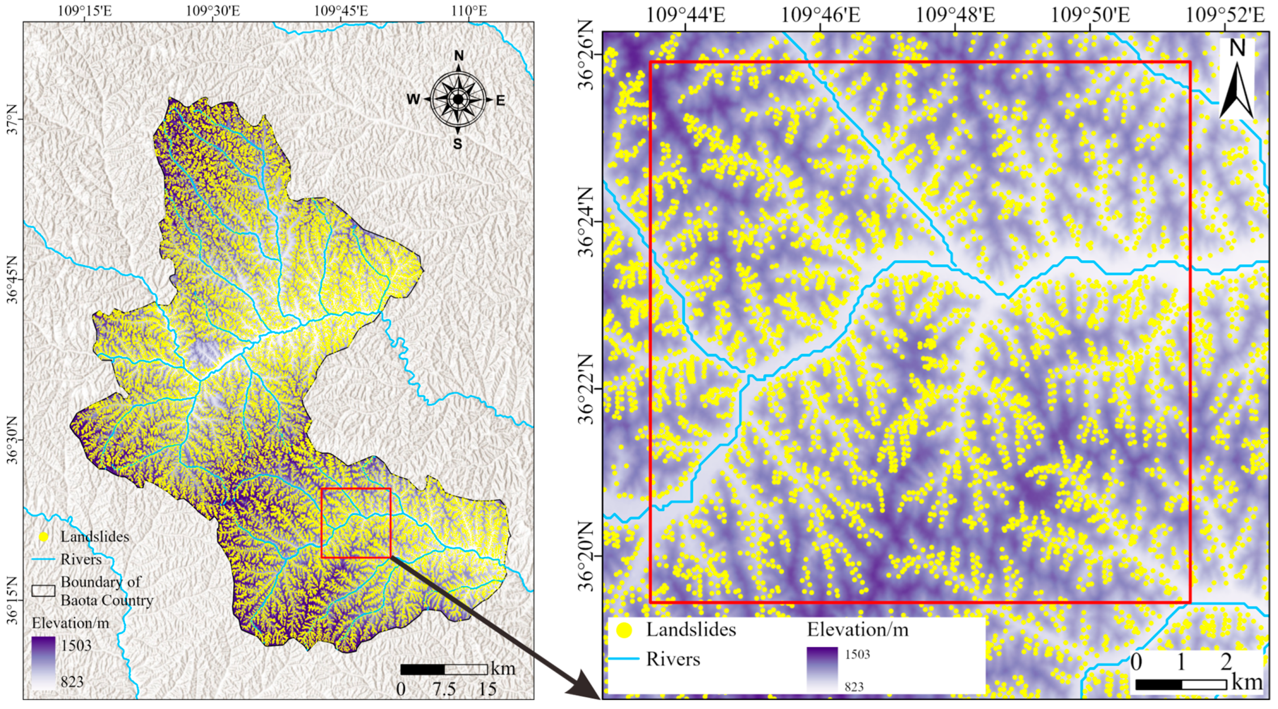
2. Study Area
3. Data and Methods
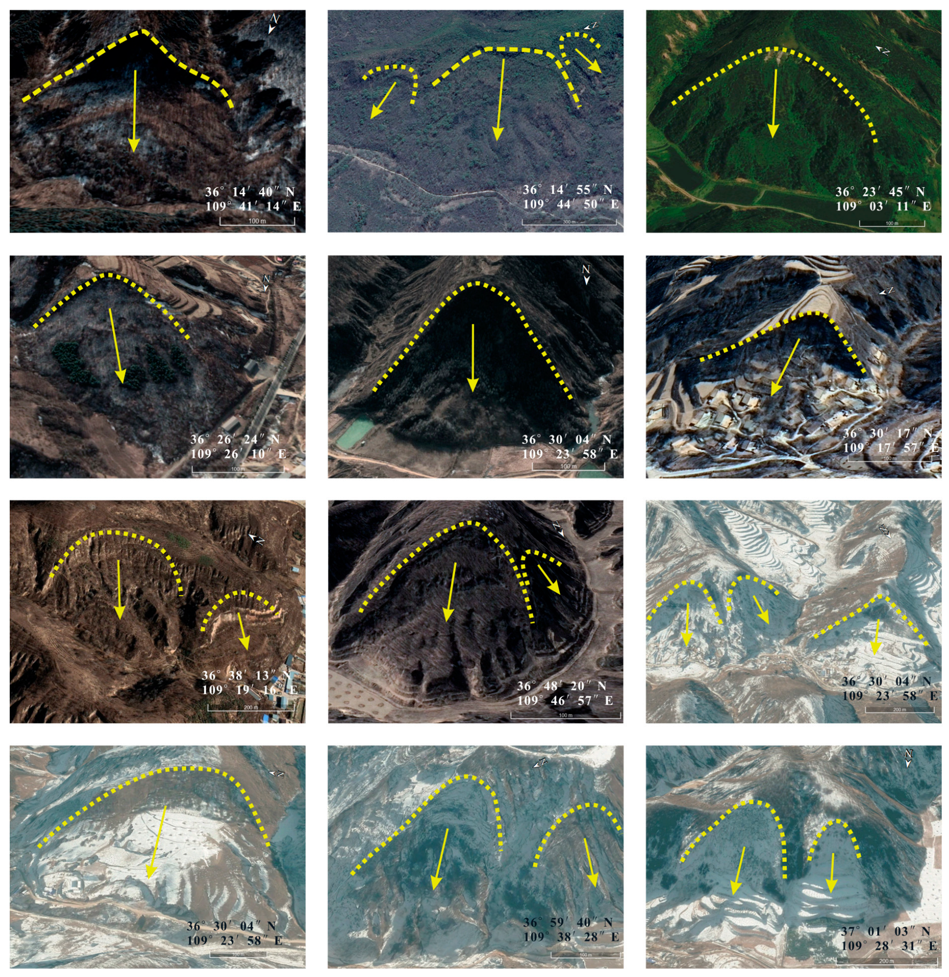
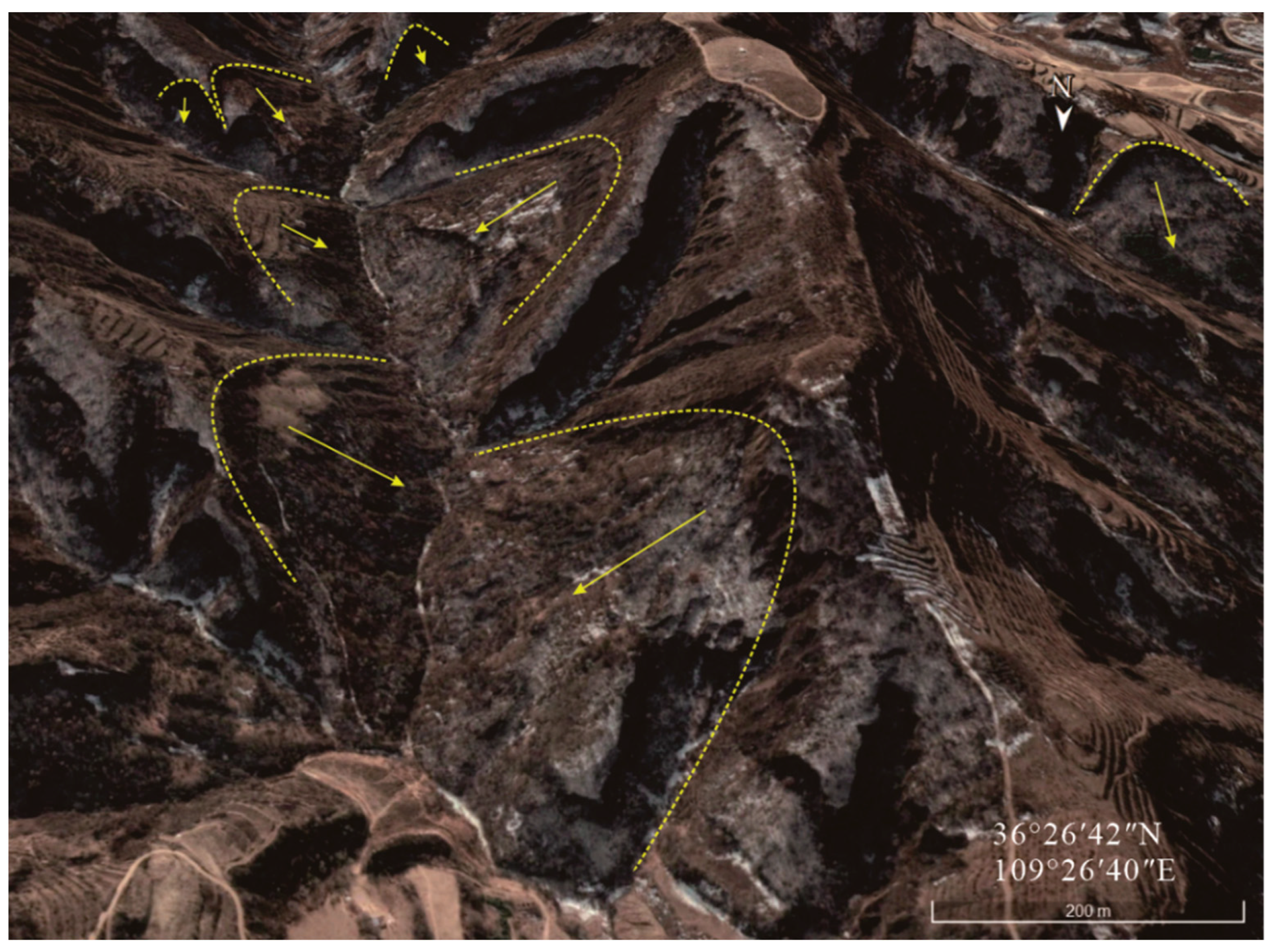
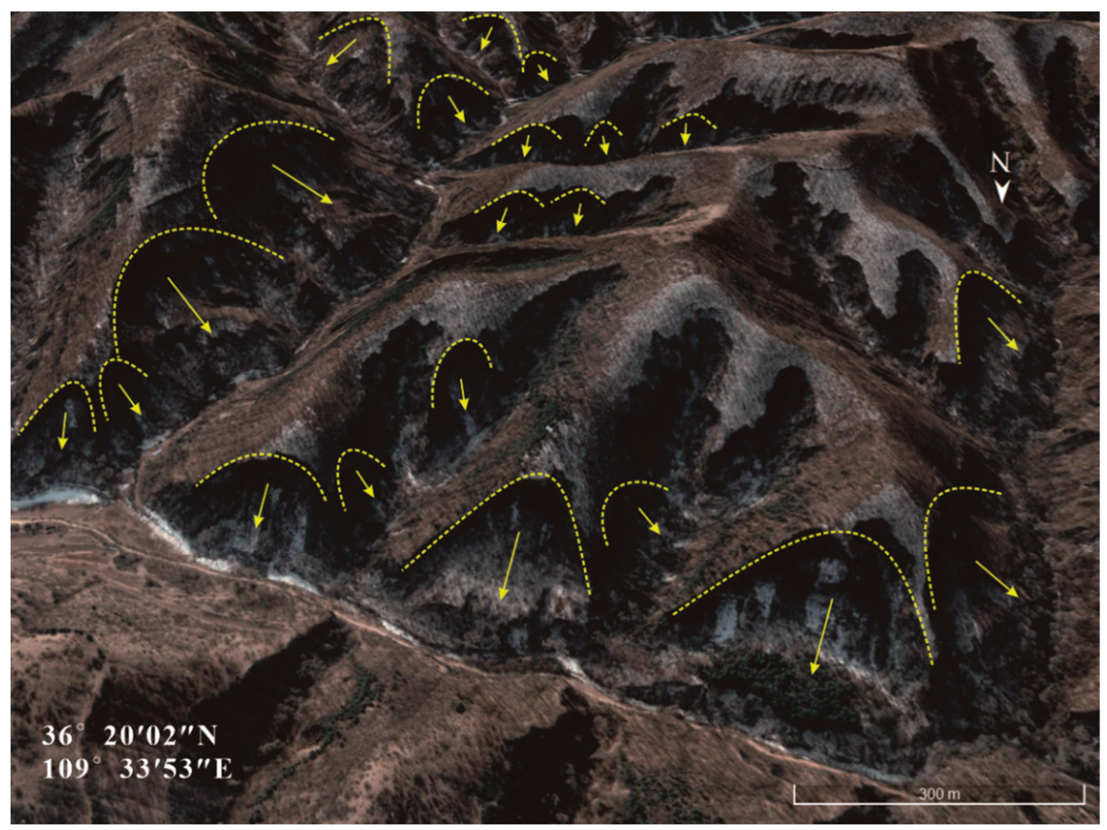
- Morphological characteristics: The landslide’s rear wall appears chair-shaped, the source area is concave, the accumulation area is convex, and cracks develop at the front of the accumulation area. The landslide body appears terraced and may be altered into farmland or residential areas.
- Vegetation cover: Landslides cause changes in vegetation cover, which can be accurately identified by comparing historical images. Additionally, densely vegetated areas may show features like “knife-shaped trees” and “drunken forests”.
- Fresh exposure: Landslide-affected slopes expose relatively fresh soil or rock at the landslide’s rear wall, displaying colors different from the surrounding undisturbed areas.
- Surface water diversion: Landslide debris near river systems may block channels, causing river diversions or forming dammed lakes.
4. Results and Analysis
4.1. Landslide Traces Inventory
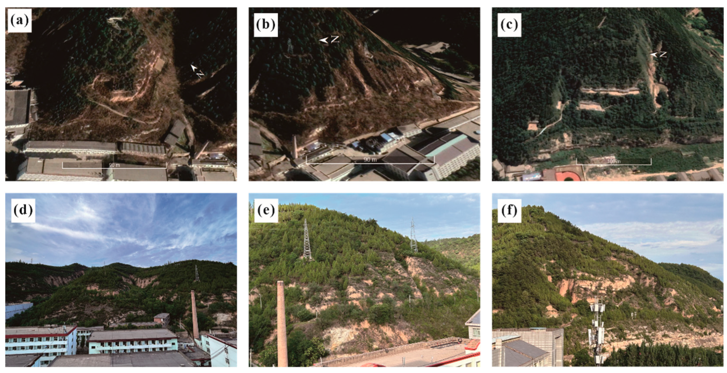
4.2. Display of Typical Landslides and Field Survey Verification
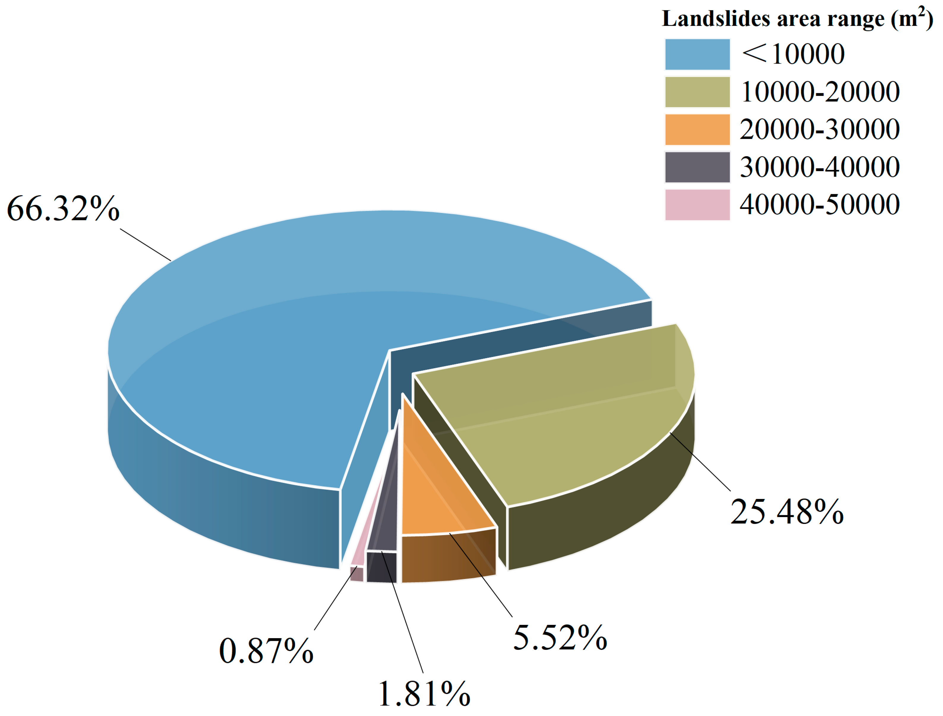
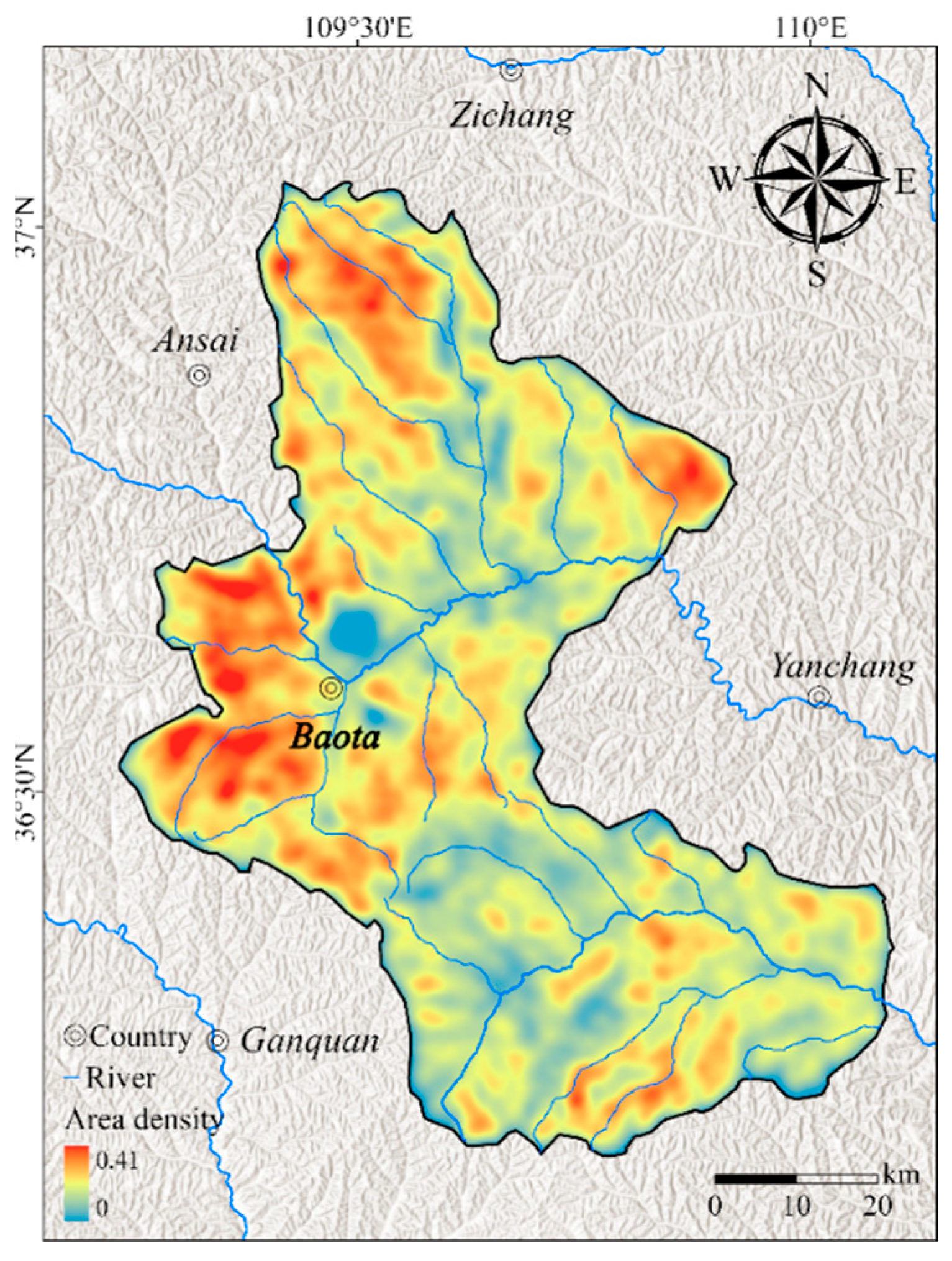
4.3. Landslide Density Statistics
5. Discussion
5.1. Characteristics of the Landslide Inventory in the Baota District and Analysis of the Importance of Establishing a Landslide Inventory in the Loess Plateau Region
5.2. Comparison with Landslide Inventories from Other Regions of the Loess Plateau
5.3. Prospects
6. Conclusions
Author Contributions
Funding
Data Availability Statement
Conflicts of Interest
References
- Mantovani, J.; Alcântara, E.; Pampuch, L.A.; Praga Baião, C.F.; Park, E.; Souza Custódio, M.; Gozzo, L.F.; Bortolozo, C.A. Assessing flood risks in the Taquari-Antas Basin (Southeast Brazil) during the September 2023 extreme rainfall surge. Npj Nat. Hazards 2024, 1, 9. [Google Scholar] [CrossRef]
- Han, Z.; Wu, G. Why do people not prepare for disasters? A national survey from China. Npj Nat. Hazards 2024, 1, 1. [Google Scholar] [CrossRef]
- Yu, X.; Hu, X.; Song, Y.; Xu, S.; Li, X.; Song, X.; Fan, X.; Wang, F. Intelligent assessment of building damage of 2023 Turkey-Syria Earthquake by multiple remote sensing approaches. Npj Nat. Hazards 2024, 1, 3. [Google Scholar] [CrossRef]
- Gariano, S.L.; Guzzetti, F. Landslides in a changing climate. Earth-Sci. Rev. 2016, 162, 227–252. [Google Scholar] [CrossRef]
- Geertsema, M.; Highland, L.; Vaugeouis, L. Environmental impact of landslides. In Landslides—Disaster Risk Reduction; Sassa, K., Canuti, P., Eds.; Springer: Berlin/Heidelberg, Germany, 2009; pp. 589–607. [Google Scholar]
- Gao, H.; Xu, C.; Xie, C.; Ma, J.; Xiao, Z. Landslides triggered by the July 2023 extreme rainstorm in the Haihe River Basin, China. Landslides 2024. [Google Scholar] [CrossRef]
- Huang, Y.; Xu, C.; He, X.; Cheng, J.; Huang, Y.; Wu, L.; Xu, X. Distribution characteristics and cumulative effects of landslides triggered by multiple moderate-magnitude earthquakes: A case study of the comprehensive seismic impact area in Yibin, Sichuan, China. Landslides 2024, 1–17. [Google Scholar] [CrossRef]
- Keefer, D.K. Investigating landslides caused by earthquakes–a historical review. Surv. Geophys. 2002, 23, 473–510. [Google Scholar] [CrossRef]
- Zhang, L.; Zhang, J.; Zhang, L.; Tang, W.H. Stability analysis of rainfall-induced slope failure: A review. Geotech. Eng. 2011, 164, 299–316. [Google Scholar] [CrossRef]
- Pardeshi, S.D.; Autade, S.E.; Pardeshi, S.S. Landslide hazard assessment: Recent trends and techniques. SpringerPlus 2013, 2, 523. [Google Scholar] [CrossRef]
- Korup, O.; Densmore, A.L.; Schlunegger, F. The role of landslides in mountain range evolution. Geomorphology 2010, 120, 77–90. [Google Scholar] [CrossRef]
- Zaruba, Q.; Mencl, V. Landslides and Their Control; Elsevier: Amsterdam, The Netherlands, 1969. [Google Scholar]
- Cruden, D. A simple definition of a landslide. Bull. Eng. Geol. Environ. 1991, 43. [Google Scholar] [CrossRef]
- Malamud, B.D.; Turcotte, D.L.; Guzzetti, F.; Reichenbach, P. Landslides, earthquakes, and erosion. Earth Planet. Sci. Lett. 2004, 229, 45–59. [Google Scholar] [CrossRef]
- Tiranti, D.; Cremonini, R. Landslide hazard in a changing environment. Front. Earth Sci. 2019, 7, 3. [Google Scholar] [CrossRef]
- Kjekstad, O.; Highland, L. Economic and social impacts of landslides. In Landslides—Disaster Risk Reduction; Sassa, K., Canuti, P., Eds.; Springer: Berlin/Heidelberg, Germany, 2009; pp. 573–587. [Google Scholar]
- Malamud, B.D.; Turcotte, D.L.; Guzzetti, F.; Reichenbach, P. Landslide inventories and their statistical properties. Earth Surf. Process. Landf. 2004, 29, 687–711. [Google Scholar] [CrossRef]
- Guzzetti, F.; Mondini, A.C.; Cardinali, M.; Fiorucci, F.; Santangelo, M.; Chang, K.T. Landslide inventory maps: New tools for an old problem. Earth-Sci. Rev. 2012, 112, 42–66. [Google Scholar] [CrossRef]
- Chigira, M.; Wu, X.; Inokuchi, T.; Wang, G. Landslides induced by the 2008 Wenchuan earthquake, Sichuan, China. Geomorphology 2010, 118, 225–238. [Google Scholar] [CrossRef]
- Emberson, R.; Kirschbaum, D.B.; Amatya, P.; Tanyas, H.; Marc, O. Insights from the topographic characteristics of a large global catalog of rainfall-induced landslide event inventories. Nat. Hazards Earth Syst. Sci. 2022, 22, 1129–1149. [Google Scholar] [CrossRef]
- Mandal, B.; Mondal, S.; Mandal, S. Modelling and mapping landslide susceptibility of Darjeeling Himalaya using geospatial technology. In Applied Geomorphology and Contemporary Issues; Mandal, S., Maiti, R., Nones, M., Beckedahl, H.R., Eds.; Springer: Berlin/Heidelberg, Germany, 2022; pp. 565–585. [Google Scholar]
- Galli, M.; Ardizzone, F.; Cardinali, M.; Guzzetti, F.; Reichenbach, P. Comparing landslide inventory maps. Geomorphology 2008, 94, 268–289. [Google Scholar] [CrossRef]
- Wieczorek, G.F. Preparing a detailed landslide-inventory map for hazard evaluation and reduction. Bull. Assoc. Eng. Geol. 1984, 21, 337–342. [Google Scholar] [CrossRef]
- Harp, E.L.; Keefer, D.K.; Sato, H.P.; Yagi, H. Landslide inventories: The essential part of seismic landslide hazard analyses. Eng. Geol. 2011, 122, 9–21. [Google Scholar] [CrossRef]
- Pennington, C.; Freeborough, K.; Dashwood, C.; Dijkstra, T.; Lawrie, K. The National Landslide Database of Great Britain: Acquisition, communication and the role of social media. Geomorphology 2015, 249, 44–51. [Google Scholar] [CrossRef]
- Rabby, Y.W.; Li, Y. Landslide inventory (2001–2017) of Chittagong hilly areas, Bangladesh. Data 2019, 5, 4. [Google Scholar] [CrossRef]
- Van Den Eeckhaut, M.; Hervás, J. State of the art of national landslide databases in Europe and their potential for assessing landslide susceptibility, hazard and risk. Geomorphology 2012, 139, 545–558. [Google Scholar] [CrossRef]
- Bentivenga, M.; Gizzi, F.T.; Palladino, G.; Piccarreta, M.; Potenza, M.R.; Perrone, A.; Bellanova, J.; Calamita, G.; Piscitelli, S. Multisource and multilevel investigations on a historical landslide: The 1907 Servigliano earth flow in Montemurro (Basilicata, Southern Italy). Land 2022, 11, 408. [Google Scholar] [CrossRef]
- Owen, L.A.; Kamp, U.; Khattak, G.A.; Harp, E.L.; Keefer, D.K.; Bauer, M.A. Landslides triggered by the 8 October 2005 Kashmir earthquake. Geomorphology 2008, 94, 1–9. [Google Scholar] [CrossRef]
- Lin, Q.; Wang, Y. Spatial and temporal analysis of a fatal landslide inventory in China from 1950 to 2016. Landslides 2018, 15, 2357–2372. [Google Scholar] [CrossRef]
- Lan, H.; Zhou, C.; Wang, L.; Zhang, H.; Li, R. Landslide hazard spatial analysis and prediction using GIS in the Xiaojiang watershed, Yunnan, China. Eng. Geol. 2004, 76, 109–128. [Google Scholar] [CrossRef]
- Shao, X.; Xu, C.; Li, L.; Yang, Z.; Yao, X.; Shao, B.; Liang, C.; Xue, Z.; Xu, X. Spatial analysis and hazard assessment of Large-scale ancient landslides around the reservoir area of Wudongde Hydropower Station, China. Nat. Hazards 2024, 120, 87–105. [Google Scholar] [CrossRef]
- Li, T.; Xu, C.; Li, L.; Xu, J. The landslide traces inventory in the transition zone between the Qinghai-Tibet Plateau and the Loess Plateau: A case study of Jianzha County, China. Front. Earth Sci. 2024, 12, 1370992. [Google Scholar] [CrossRef]
- Wang, W.; Huang, Y.; Xu, C.; Shao, X.; Li, L.; Feng, L.; Gao, H.; Cui, Y.; Wu, S.; Yang, Z. Identification and distribution of 13,003 landslides in the northwest margin of Qinghai-Tibet Plateau based on human-computer interaction remote sensing interpretation. China Geol. 2024, 7, 171–187. [Google Scholar] [CrossRef]
- Feng, L.; Xu, C.; Tian, Y.; Li, L.; Sun, J.; Huang, Y.; Wang, P.; Zhang, X.; Li, T.; Yang, W. Landslides of China’s Qinling. Geosci. Data J. 2024. [Google Scholar] [CrossRef]
- Li, Y. A review of shear and tensile strengths of the Malan Loess in China. Eng. Geol. 2018, 236, 4–10. [Google Scholar] [CrossRef]
- Peng, J.; Lin, H.; Wang, Q.; Zhuang, J.; Cheng, Y.; Zhu, X. The critical issues and creative concepts in mitigation research of loess geological hazards. J. Eng. Geol. 2014, 22, 684–691. [Google Scholar]
- Huo, A.; Yang, L.; Peng, J.; Cheng, Y.; Jiang, C. Spatial characteristics of the rainfall induced landslides in the Chinese Loess Plateau. Hum. Ecol. Risk Assess. Int. J. 2020, 26, 2462–2477. [Google Scholar] [CrossRef]
- Zhuang, J.; Peng, J.; Wang, G.; Javed, I.; Wang, Y.; Li, W. Distribution and characteristics of landslide in Loess Plateau: A case study in Shaanxi province. Eng. Geol. 2018, 236, 89–96. [Google Scholar] [CrossRef]
- Derbyshire, E. Geological hazards in loess terrain, with particular reference to the loess regions of China. Earth-Sci. Rev. 2001, 54, 231–260. [Google Scholar] [CrossRef]
- Xu, X.; Guo, W.; Liu, Y.; Ma, J.; Wang, W.; Zhang, H.; Gao, H. Landslides on the Loess Plateau of China: A latest statistics together with a close look. Nat. Hazards 2017, 86, 1393–1403. [Google Scholar] [CrossRef]
- Li, T.; Wang, C.; Li, P. Loess Deposit and Loess Landslides on the Chinese Loess Plateau. Progress of Geo-Disaster Mitigation Technology in Asia; Wang, F., Miyajima, M., Li, T., Shan, W., Fathani, T.F., Eds.; Springer: Berlin/Heidelberg, Germany, 2013; pp. 235–261. [Google Scholar]
- Zhang, M.; Li, T. Triggering factors and forming mechanism of loess landslides. J. Eng. Geol. 2011, 19, 530–540. [Google Scholar]
- Meng, Z.; Ma, P.; Peng, J. Characteristics of loess landslides triggered by different factors in the Chinese Loess Plateau. J. Mt. Sci. 2021, 18, 3218–3229. [Google Scholar] [CrossRef]
- Zhang, J.; Gao, G.; Fu, B.; Wang, C.; Gupta, H.V.; Zhang, X.; Li, R. A universal multifractal approach to assessment of spatiotemporal extreme precipitation over the Loess Plateau of China. Hydrol. Earth Syst. Sci. 2020, 24, 809–826. [Google Scholar] [CrossRef]
- Peng, D.; Xu, Q.; Qi, X.; Fan, X.; Dong, X.; Li, S.; Ju, Y. Study on early recognition of loess landslides based on field investigation. Int. J. Georesources Environ. 2016, 2, 35–52. [Google Scholar] [CrossRef]
- Xu, Y.; Allen, M.B.; Zhang, W.; Li, W.; He, H. Landslide characteristics in the Loess Plateau, northern China. Geomorphology 2020, 359, 107150. [Google Scholar] [CrossRef]
- Zhu, J.; Chen, Z.; Zhu, Y. Distribution regularity and development characteristic of landslides in Yan’an. Geol. Sci. Techology Inf. 2017, 36, 236–243. [Google Scholar] [CrossRef]
- Li, L.; Xu, C.; Xu, X.; Zhang, Z.; Cheng, J. Inventory and distribution characteristics of large-scale landslides in Baoji city, Shaanxi province, China. ISPRS Int. J. Geo-Inf. 2021, 11, 10. [Google Scholar] [CrossRef]
- Chen, J.; Li, L.; Xu, C.; Huang, Y.; Luo, Z.; Xu, X.; Lyu, Y. Freely accessible inventory and spatial distribution of large-scale landslides in Xianyang City, Shaanxi Province, China. Earthq. Res. Adv. 2023, 3, 100217. [Google Scholar] [CrossRef]
- Zhao, J.; Xu, C.; Huang, X. Detailed landslide traces database of Hancheng County, China, based on high-resolution satellite images available on the Google Earth Platform. Data 2024, 9, 63. [Google Scholar] [CrossRef]
- Wang, H.; Zhou, B.; Wu, S.; Shi, J.; Li, B. Characteristic analysis of large-scale loess landslides: A case study in Baoji City of Loess Plateau of Northwest China. Nat. Hazards Earth Syst. Sci. 2011, 11, 1829–1837. [Google Scholar] [CrossRef]
- Liu, F.; Deng, Y.; Zhang, T.; Qian, F.; Yang, N.; Teng, H.; Shi, W.; Han, X. Landslide distribution and development characteristics in the Beiluo River Basin. Land 2024, 13, 1038. [Google Scholar] [CrossRef]
- Zhang, M.; Xiao, P.; Wei, X. Geological Disasters of Landslides and Failures in Baota Country, Yan’an; Geology Press: Beijing, China, 2008. [Google Scholar]
- Sun, J. Loessology; Hong Kong Archaeological Society Press: Hong Kong, China, 2005. [Google Scholar]
- Wang, G.; Li, T.; Xing, X.; Zou, Y. Research on loess flow-slides induced by rainfall in July 2013 in Yan’an, NW China. Environ. Earth Sci. 2015, 73, 7933–7944. [Google Scholar] [CrossRef]
- Wang, T.; Zhao, X.; Qi, J. Impact of continued heavy rainfall on loess land slide hazard areas: A case study on Yan’an. Geol. Surv. Res. 2014, 37, 224–229. [Google Scholar]
- Fan, Z. Study on the Formation Mechanism of Loess Landslide Triggered by Excavated Slope-Case of Yan’an Liu Wanjiagou Landslide; Chang’an University: Xi’an, China, 2013. [Google Scholar]
- Zhang, F. Experimental Study on Deformation and Damage of Loess Slope under Excavation and Unloading Effect; Chang’an University: Xi’an, China, 2023. [Google Scholar]
- Brunsden, D. Landslide types, mechanisms, recognition, identification. In Proceedings of the Landslides in the South Wales coalfield Symposium, Treforest, Wales, 1–3 April 1985; pp. 1–3. [Google Scholar]
- Martha, T.R.; van Westen, C.J.; Kerle, N.; Jetten, V.; Kumar, K.V. Landslide hazard and risk assessment using semi-automatically created landslide inventories. Geomorphology 2013, 184, 139–150. [Google Scholar] [CrossRef]
- Lei, T.; Zhang, Y.; Lv, Z.; Li, S.; Liu, S.; Nandi, A.K. Landslide inventory mapping from bitemporal images using deep convolutional neural networks. IEEE Geosci. Remote Sens. Lett. 2019, 16, 982–986. [Google Scholar] [CrossRef]
- Ju, Y.; Xu, Q.; Jin, S.; Li, W.; Dong, X.; Guo, Q. Automatic object detection of loess landslide based on deep learning. Geomat. Inf. Sci. Wuhan Univ. 2020, 45, 1747–1755. [Google Scholar]
- Fayne, J.V.; Ahamed, A.; Roberts-Pierel, J.; Rumsey, A.C.; Kirschbaum, D. Automated satellite-based landslide identification product for Nepal. Earth Interact. 2019, 23, 1–21. [Google Scholar] [CrossRef]
- Milledge, D.G.; Bellugi, D.G.; Watt, J.; Densmore, A.L. Automated determination of landslide locations after large trigger events: Advantages and disadvantages compared to manual mapping. Nat. Hazards Earth Syst. Sci. 2022, 22, 481–508. [Google Scholar] [CrossRef]
- Meena, S.R.; Soares, L.P.; Grohmann, C.H.; Van Westen, C.; Bhuyan, K.; Singh, R.P.; Floris, M.; Catani, F. Landslide detection in the Himalayas using machine learning algorithms and U-Net. Landslides 2022, 19, 1209–1229. [Google Scholar] [CrossRef]
- Xu, C. Preparation of earthquake-triggered landslide inventory maps using remote sensing and GIS technologies: Principles and case studies. Geosci. Front. 2015, 6, 825–836. [Google Scholar] [CrossRef]
- Delgado, F.; Zerathe, S.; Schwartz, S.; Mathieux, B.; Benavente, C. Inventory of large landslides along the Central Western Andes (ca. 15–20 S): Landslide distribution patterns and insights on controlling factors. J. South Am. Earth Sci. 2022, 116, 103824. [Google Scholar] [CrossRef]
- Litoseliti, A.; Koukouvelas, I.K.; Nikolakopoulos, K.G.; Zygouri, V. An event-based inventory approach in landslide hazard assessment: The case of the Skolis Mountain, Northwest Peloponnese, Greece. ISPRS Int. J. Geo-Inf. 2020, 9, 457. [Google Scholar] [CrossRef]
- Tanyaş, H.; Görüm, T.; Fadel, I.; Yıldırım, C.; Lombardo, L. An open dataset for landslides triggered by the 2016 Mw 7.8 Kaikōura earthquake, New Zealand. Landslides 2022, 19, 1405–1420. [Google Scholar] [CrossRef]
- Ge, R.; Chen, J.; Ma, S.; Tan, H. Inventory and Spatial Distribution of Landslides on the Eastern Slope of Gongga Mountain, Southwest China. Remote Sens. 2024, 16, 3360. [Google Scholar] [CrossRef]
- Tang, C.; Zhu, J.; Qi, X.; Ding, J. Landslides induced by the Wenchuan earthquake and the subsequent strong rainfall event: A case study in the Beichuan area of China. Eng. Geol. 2011, 122, 22–33. [Google Scholar] [CrossRef]
- Fan, X.; Scaringi, G.; Xu, Q.; Zhan, W.; Dai, L.; Li, Y.; Pei, X.; Yang, Q.; Huang, R. Coseismic landslides triggered by the 8th August 2017 M s 7.0 Jiuzhaigou earthquake (Sichuan, China): Factors controlling their spatial distribution and implications for the seismogenic blind fault identification. Landslides 2018, 15, 967–983. [Google Scholar] [CrossRef]
- Rabby, Y.W.; Li, Y. An integrated approach to map landslides in Chittagong Hilly Areas, Bangladesh, using Google Earth and field mapping. Landslides 2019, 16, 633–645. [Google Scholar] [CrossRef]
- Tang, C.; Van Westen, C.J.; Tanyas, H.; Jetten, V.G. Analysing post-earthquake landslide activity using multi-temporal landslide inventories near the epicentral area of the 2008 Wenchuan earthquake. Nat. Hazards Earth Syst. Sci. 2016, 16, 2641–2655. [Google Scholar] [CrossRef]
- Fisher, G.B.; Amos, C.B.; Bookhagen, B.; Burbank, D.W.; Godard, V.; Whitmeyer, S.J. Channel widths, landslides, faults, and beyond: The new world order of high-spatial resolution Google Earth imagery in the study of earth surface processes. Geol. Soc. Am. Spec. Pap. 2012, 492, 1–22. [Google Scholar]
- Ding, H.; Zhang, M.; Li, L. Interpreting landslides in the northwestern Loess Plateau using remote sesing images. Quat. Sci. 2011, 31, 1077–1085. [Google Scholar]
- Sato, H.; Harp, E. Interpretation of earthquake-induced landslides triggered by the 12 May 2008, M7. 9 Wenchuan earthquake in the Beichuan area, Sichuan Province, China using satellite imagery and Google Earth. Landslides 2009, 6, 153–159. [Google Scholar] [CrossRef]
- Korup, O.; Clague, J.J.; Hermanns, R.L.; Hewitt, K.; Strom, A.L.; Weidinger, J.T. Giant landslides, topography, and erosion. Earth Planet. Sci. Lett. 2007, 261, 578–589. [Google Scholar] [CrossRef]
- Schuster, R.L.; Fleming, R.W. Economic losses and fatalities due to landslides. Bull. Assoc. Eng. Geol. 1986, 23, 11–28. [Google Scholar] [CrossRef]
- Huang, Y.; Xu, C.; Zhang, X.; Li, L.; Xu, X. Research in the field of natural hazards based on bibliometric analysis. Nat. Hazards Rev. 2023, 24, 04023012. [Google Scholar] [CrossRef]
- Wu, X.; Chen, X.; Zhan, F.B.; Hong, S. Global research trends in landslides during 1991–2014: A bibliometric analysis. Landslides 2015, 12, 1215–1226. [Google Scholar] [CrossRef]
- Cohen, D.; Schwarz, M. Tree-root control of shallow landslides. Earth Surf. Dyn. 2017, 5, 451–477. [Google Scholar] [CrossRef]
- Huang, X.; Wei, Z.; Yi, W.; Guo, F.; Huang, H.; Xiao, Y. Mechanism of fracture preferential flow infiltration-induced shallow damage of colluvial landslides. Chin. J. Geotech. Eng. 2024, 46, 1136–1145. [Google Scholar]
- Varnes, D.J. Landslide types and processes. Landslides Eng. Pract. 1958, 24, 20–47. [Google Scholar]
- Varnes, D.J. Slope movement types and processes. Landslides: Anal. Control. 1978, 176, 11–33. [Google Scholar]
- Hungr, O.; Leroueil, S.; Picarelli, L. The Varnes classification of landslide types, an update. Landslides 2014, 11, 167–194. [Google Scholar] [CrossRef]
- Chen, Z.; Huang, Y.; He, X.; Shao, X.; Li, L.; Xu, C.; Wang, S.; Xu, X.; Xiao, Z. Landslides triggered by the 10 June 2022 Maerkang earthquake swarm, Sichuan, China: Spatial distribution and tectonic significance. Landslides 2023, 20, 2155–2169. [Google Scholar] [CrossRef]
- Xiao, Z.; Xu, C.; Huang, Y.; He, X.; Shao, X.; Chen, Z.; Xie, C.; Li, T.; Xu, X. Analysis of spatial distribution of landslides triggered by the Ms 6.8 Luding earthquake in China on September 5, 2022. Geoenviron. Disasters 2023, 10, 3. [Google Scholar] [CrossRef]
- Chang, C.; Bo, J.; Qi, W.; Qiao, F.; Peng, D. Distribution of large-and medium-scale loess landslides induced by the Haiyuan Earthquake in 1920 based on field investigation and interpretation of satellite images. Open Geosci. 2022, 14, 995–1019. [Google Scholar] [CrossRef]
- Zhou, C.; Lee, C.F.; Li, J.; Xu, Z. On the spatial relationship between landslides and causative factors on Lantau Island, Hong Kong. Geomorphology 2002, 43, 197–207. [Google Scholar] [CrossRef]


Disclaimer/Publisher’s Note: The statements, opinions and data contained in all publications are solely those of the individual author(s) and contributor(s) and not of MDPI and/or the editor(s). MDPI and/or the editor(s) disclaim responsibility for any injury to people or property resulting from any ideas, methods, instructions or products referred to in the content. |
© 2024 by the authors. Licensee MDPI, Basel, Switzerland. This article is an open access article distributed under the terms and conditions of the Creative Commons Attribution (CC BY) license (https://creativecommons.org/licenses/by/4.0/).
Share and Cite
Zhang, S.; Xu, C.; Meng, Z.; Li, T.; Li, C.; Huang, Y.; Shao, X.; Feng, L.; Luo, P.; Luo, C. Establishing a Landslide Traces Inventory for the Baota District, Yan’an City, China, Using High-Resolution Satellite Images. Land 2024, 13, 1580. https://doi.org/10.3390/land13101580
Zhang S, Xu C, Meng Z, Li T, Li C, Huang Y, Shao X, Feng L, Luo P, Luo C. Establishing a Landslide Traces Inventory for the Baota District, Yan’an City, China, Using High-Resolution Satellite Images. Land. 2024; 13(10):1580. https://doi.org/10.3390/land13101580
Chicago/Turabian StyleZhang, Sen, Chong Xu, Zhenjiang Meng, Tao Li, Chao Li, Yuandong Huang, Xiaoyi Shao, Liye Feng, Penghan Luo, and Changyou Luo. 2024. "Establishing a Landslide Traces Inventory for the Baota District, Yan’an City, China, Using High-Resolution Satellite Images" Land 13, no. 10: 1580. https://doi.org/10.3390/land13101580